


![]()

zprávy
zdroje zpráv:Interview with Jeff Dawley, Director of Intelligence Programs, Esri
21.10.2021 9:00 GISCafe.com Webcasts-WebinarsHLEDÁME DO TÝMU: Operátorka GIS s ArcGIS QGIS (HPP)
20.10.2021 17:42 TopGis Hledáme novou posilu do našeho týmu. Jsme společnost s dlouholetou praxí v oboru geoinformačních technologií. Provozujeme vlastní datové centrum s jedinečnými mapovými podklady ČR a mapovou aplikaci GisOnline.cz. Co musíte umět? Co Vám nabízíme: Zaujala Vás naše nabídka? Ozvěte se nám! Pošlete prosím svůj životopis na kariera@topgis.cz nebo dejte vědět Vašim známým. Pro umožnění výběrového řízení naAlpine 4 Holdings (ALPP) Debuts on the Nasdaq and Announces the Acquisition of Identified Technologies, a Drone Mapping Software Company
20.10.2021 17:21 GISCafe.com Webcasts-Webinars PHOENIX, Oct. 20, 2021 — (PRNewswire) — Alpine 4 Holdings, Inc. (Nasdaq: ALPP), a leading operator and owner of small market …Esri Partners with The Ray to Map Solar Energy Hot Spots
20.10.2021 17:15 GISCafe.com Webcasts-Webinars New Tool Enables Departments of Transportation to Analyze Rights-of-Way for Zero-Carbon Electric Grid ExpansionREDLANDS, Calif. — (BUSINESS …
Swift Navigation Honored As “Fleet Management Technology Company of the Year”
20.10.2021 17:15 GISCafe.com Webcasts-Webinars SAN FRANCISCO, Oct. 20, 2021 (GLOBE NEWSWIRE) -- Swift Navigation, a San Francisco-based tech firm redefining GNSS (Global Navigation Satellite …DGT Associates Launches Owned Subsurface Mobile Mapping System
20.10.2021 17:15 GISCafe.com Webcasts-Webinars Solution Enables Safer, Faster, More Accurate Capture of Underground EnvironmentBOSTON — (BUSINESS WIRE) — October 20, 2021 —
DGT …
Lumotive Names Dr. Sam Heidari as CEO to Lead Lidar Innovator’s Next Stage of Growth
20.10.2021 17:15 GISCafe.com Webcasts-Webinars SEATTLE, Oct. 20, 2021 (GLOBE NEWSWIRE) -- Lumotive, a leading developer of solid-state lidar systems for automotive, industrial and consumer …Movitý majetek - PC, notebook a monitory
20.10.2021 14:26 ČÚZK /Urady/Katastralni-urady/Katastralni-urady/Katastralni-urad-pro-Pardubicky-kraj/Nabidky-majetku/Movity-majetek-PC,-notebook-a-monitoryMovitý majetek - PC, notebook a monitory
20.10.2021 14:26 ČÚZK - předpisy a opatřeníKatastrální úřad pro Pardubický kraj nabízí nepotřebný majetek k odkupu. Jedná se o PC notebook a monitory
Movitý majetek - PC, notebook a monitory
Geodet/ka
20.10.2021 12:52 ČÚZK - předpisy a opatření Zeměměřický úřadvypisuje výběrové řízení na místo
Geodet/ka
Geodet/ka
20.10.2021 12:52 ČÚZK - volná místa Zeměměřický úřad vypisuje výběrové řízení na místo Geodet/kaGeodet/ka
20.10.2021 12:52 Zeměměřický úřad Zeměměřický úřadvypisuje výběrové řízení na místo
Geodet/ka
Geodet/ka
20.10.2021 12:52 ČÚZK /Urady/Zememericky-urad/Uredni-deska/Oznameni-a-jina-uredni-sdeleni/Volna-mista/Geodet-ka20211020 - zrušení distribuční skupiny VFK k 1.11.2021
20.10.2021 12:02 ČÚZK - předpisy a opatření Katastrální úřad pro Ústecký kraj - Katastrální pracoviště Žatec zveřejnil novou aktualitu: Dne 1.11.2021 bude zrušena mailová distribuční adresa vfk.zatec@cuzk.cz sloužící pro součinnost katastrálního pracoviště při vyhotovování geometrických plánů.20211020 - zrušení distribuční skupiny VFK k 1.11.2021
20.10.2021 12:02 ČÚZK /Urady/Katastralni-urady/Katastralni-urady/Katastralni-urad-pro-Ustecky-kraj/Katastralni-pracoviste/KP-Zatec/O-uradu/Aktuality/20211020-zruseni-distribucni-skupiny-VFK-k-1-1120211020 - zrušení distribuční skupiny VFK k 1.11.2021
20.10.2021 12:02 ČÚZK - předpisy a opatření Katastrální úřad pro Ústecký kraj - Katastrální pracoviště Teplice zveřejnil novou aktualitu: Dne 1.11.2021 bude zrušena mailová distribuční adresa vfk.teplice@cuzk.cz sloužící pro součinnost katastrálního pracoviště při vyhotovování geometrických plánů.20211020 - zrušení distribuční skupiny VFK k 1.11.2021
20.10.2021 12:02 ČÚZK /Urady/Katastralni-urady/Katastralni-urady/Katastralni-urad-pro-Ustecky-kraj/Katastralni-pracoviste/KP-Teplice/O-uradu/Aktuality/20211020-zruseni-distribucni-skupiny-VFK-k-1-1120211020 - zrušení distribuční skupiny VFK k 1.11.2021
20.10.2021 12:01 ČÚZK /Urady/Katastralni-urady/Katastralni-urady/Katastralni-urad-pro-Ustecky-kraj/Katastralni-pracoviste/KP-Rumburk/O-uradu/Aktuality/20211020-zruseni-distribucni-skupiny-VFK-k-1-1120211020 - zrušení distribuční skupiny VFK k 1.11.2021
20.10.2021 12:01 ČÚZK - předpisy a opatření Katastrální úřad pro Ústecký kraj - Katastrální pracoviště Rumburk zveřejnil novou aktualitu: Dne 1.11.2021 bude zrušena mailová distribuční adresa vfk.rumburk@cuzk.cz sloužící pro součinnost katastrálního pracoviště při vyhotovování geometrických plánů.20211020 - zrušení distribuční skupiny VFK k 1.11.2021
20.10.2021 12:00 ČÚZK /Urady/Katastralni-urady/Katastralni-urady/Katastralni-urad-pro-Ustecky-kraj/Katastralni-pracoviste/KP-Most/O-uradu/Aktuality/20211020-zruseni-distribucni-skupiny-VFK-k-1-1120211020 - zrušení distribuční skupiny VFK k 1.11.2021
20.10.2021 12:00 ČÚZK - předpisy a opatření Katastrální úřad pro Ústecký kraj - Katastrální pracoviště Most zveřejnil novou aktualitu: Dne 1.11.2021 bude zrušena mailová distribuční adresa vfk.most@cuzk.cz sloužící pro součinnost katastrálního pracoviště při vyhotovování geometrických plánů.20211020 - zrušení distribuční skupiny VFK k 1.11.2021
20.10.2021 11:59 ČÚZK /Urady/Katastralni-urady/Katastralni-urady/Katastralni-urad-pro-Ustecky-kraj/Katastralni-pracoviste/KP-Louny/O-uradu/Aktuality/20211020-zruseni-distribucni-skupiny-VFK-k-1-1120211020 - zrušení distribuční skupiny VFK k 1.11.2021
20.10.2021 11:59 ČÚZK - předpisy a opatření Katastrální úřad pro Ústecký kraj - Katastrální pracoviště Louny zveřejnil novou aktualitu: Dne 1.11.2021 bude zrušena mailová distribuční adresa vfk.louny@cuzk.cz sloužící pro součinnost katastrálního pracoviště při vyhotovování geometrických plánů.20211020 - zrušení distribuční skupiny VFK k 1.11.2021
20.10.2021 11:59 ČÚZK /Urady/Katastralni-urady/Katastralni-urady/Katastralni-urad-pro-Ustecky-kraj/Katastralni-pracoviste/KP-Litomerice/O-uradu/Aktuality/20211020-zruseni-distribucni-skupiny-VFK-k-1-1120211020 - zrušení distribuční skupiny VFK k 1.11.2021
20.10.2021 11:59 ČÚZK - předpisy a opatření Katastrální úřad pro Ústecký kraj - Katastrální pracoviště Litoměřice zveřejnil novou aktualitu: Dne 1.11.2021 bude zrušena mailová distribuční adresa vfk.litomerice@cuzk.cz sloužící pro součinnost katastrálního pracoviště při vyhotovování geometrických plánů.20211020 - zrušení distribuční skupiny VFK k 1.11.2021
20.10.2021 11:57 ČÚZK /Urady/Katastralni-urady/Katastralni-urady/Katastralni-urad-pro-Ustecky-kraj/Katastralni-pracoviste/KP-Chomutov/O-uradu/Aktuality/20211020-zruseni-distribucni-skupiny-VFK-k-1-1120211020 - zrušení distribuční skupiny VFK k 1.11.2021
20.10.2021 11:57 ČÚZK - předpisy a opatření Katastrální úřad pro Ústecký kraj - Katastrální pracoviště Chomutov zveřejnil novou aktualitu: Dne 1.11.2021 bude zrušena mailová distribuční adresa vfk.chomutov@cuzk.cz sloužící pro součinnost katastrálního pracoviště při vyhotovování geometrických plánů.20211020 - zrušení distribuční skupiny VFK k 1.11.2021
20.10.2021 11:56 ČÚZK /Urady/Katastralni-urady/Katastralni-urady/Katastralni-urad-pro-Ustecky-kraj/Katastralni-pracoviste/KP-Decin/O-uradu/Aktuality/20211020-zruseni-distribucni-skupiny-VFK-k-1-1120211020 - zrušení distribuční skupiny VFK k 1.11.2021
20.10.2021 11:56 ČÚZK - předpisy a opatření Katastrální úřad pro Ústecký kraj - Katastrální pracoviště Děčín zveřejnil novou aktualitu: Dne 1.11.2021 bude zrušena mailová distribuční adresa vfk.decin@cuzk.cz sloužící pro součinnost katastrálního pracoviště při vyhotovování geometrických plánů.20210120 - Statistické údaje
20.10.2021 8:35 ČÚZK - aktuality v resortu Zveřejněny statistické údaje za 3. čtvrtletí roku 2021 o vybraných transakcích s nemovitostmi evidovanými v KN.20210120 - Statistické údaje
20.10.2021 8:35 ČÚZK /Aktuality-resort/2021/20210120-Statisticke-udaje-(1)20210120 - Statistické údaje
20.10.2021 8:35 ČÚZK - předpisy a opatření Český úřad zeměměřický a katastrální zveřejnil novou aktualitu: Zveřejněny statistické údaje za 3. čtvrtletí roku 2021 o vybraných transakcích s nemovitostmi evidovanými v KN.SatLab New Product | Freyja Launch Meeting on Facebook
20.10.2021 3:49 Satlab GeosolutionsSatLab Freyja, The Compact RTK with Advanced IMU Sensor. SatLab Freyja is an innovative GNSS RTK Receiver that promises a new RTK experience for land survey users. Meet our New Product | Freyja Launch Meeting We are very proud to announce the launch of Freyja. With an advanced IMU sensor, the Freyja GNSS RTK offers […]
The post SatLab New Product | Freyja Launch Meeting on Facebook appeared first on SatLab – Global Satellite Positioning Solutions.
9. Mezinárodní geografické kolokvium - Danišovce 2021
20.10.2021 0:00 Geografický ústav MUZveme Vás na 9. Mezinárodní geografické kolokvium, které se koná ve dnech 20.-22. října 2021 v obci Danišovce u Spišské Nové Vsi.
Bližší informace naleznete ZDE.
Bentley Systems to Announce Third Quarter 2021 Operating Results Presenting at Upcoming Conferences
19.10.2021 22:59 Bentley SystemsPress Announcements
Geo Week Conference Program and Speaker Lineup Announced
19.10.2021 20:27 GISCafe.com Webcasts-Webinars 125+ speakers and 50+ sessions confirmed for the 2022 edition of Geo Week in Denver, COPORTLAND, Maine, Oct. 19, 2021 — (PRNewswire) — …
AgEagle to Acquire senseFly from Parrot
19.10.2021 17:23 GISCafe.com Webcasts-Webinars WICHITA, Kan. and PARIS and LAUSANNE, Switzerland, Oct. 18, 2021 (GLOBE NEWSWIRE) -- AgEagle Aerial Systems Inc. (NYSE American: UAVS) …Trimble Releases Turnkey Autonomous Robotic Scanning Solution
19.10.2021 17:22 GISCafe.com Webcasts-Webinars Boston Dynamics' Spot Robot Fully Integrated with the Trimble X7 3D Laser Scanner and Trimble FieldLink Software Now Available as a Complete Solution …Spire Global Launches Maritime 2.0 - a Milestone Data Services Update Supported by GraphQL
19.10.2021 17:22 GISCafe.com Webcasts-Webinars Space-based data addresses port congestion, saves fuel for maritime vessels and streamlines today’s strained global supply chainsVIENNA, Va. …
Wejo Integrates With Microsoft Mapping Services to Provide Real-Time Transportation Data
19.10.2021 17:22 GISCafe.com Webcasts-Webinars Wejo’s Proprietary Data to Create Real-Time Mapping SolutionsMANCHESTER, England — (BUSINESS WIRE) — October 19, 2021 —
Wejo, a …
Bad Elf Bundles ProStar's PointMan Data Collection Software with the Bad Elf Flex™ GNSS Receiver
19.10.2021 17:22 GISCafe.com Webcasts-Webinars WEST HARTFORD, Conn., Oct. 19, 2021 — (PRNewswire) — Bad Elf, LLC announces that all current and future Bad Elf Flex purchases …Woolpert Awarded 2 Michigan Statewide Imagery Contracts, Partnering with Planet, EagleView
19.10.2021 17:22 GISCafe.com Webcasts-Webinars The three-year contracts will procure satellite and oblique imagery for multiple infrastructure applications.LANSING, Mich., Oct. 19, 2021 — …
Cartegraph Celebrates 2020-21 High-Performance Operations, Flag Forward Award Winners
19.10.2021 17:22 GISCafe.com Webcasts-Webinars DUBUQUE, Iowa — (BUSINESS WIRE) — October 19, 2021 —Cartegraph, a leader in infrastructure management software, is pleased to …
Fortem DroneHunter Successfully Takes Down Target Drone at Norway's Avinor Oslo Airport in Landmark Test Event
19.10.2021 17:22 GISCafe.com Webcasts-Webinars For the first time globally, international police intercepted drones at an airport without stopping trafficPLEASANT GROVE, Utah, Oct. 19, 2021 …
Septentrio partners with ArduSimple, bringing reliable GPS/GNSS to emerging applications
19.10.2021 16:47 GISCafe.com Webcasts-Webinars The mosaic-X5 and mosaic-H modules are being integrated into ArduSimple’s new evaluation kits, making resilient cm-level positioning easily …Humans to blame for warming lakes
19.10.2021 16:20 ESA Observing the Earth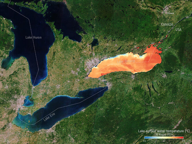
While the climate crisis is, unfortunately, a reality, it is all too easy to assume that every aspect of our changing world is a consequence of climate change. Assumptions play no role in key environmental assessments and mitigation strategies such as we will see in the upcoming UN climate change COP-26 conference – it’s the science and hard facts that are critical. New research published this week is a prime example of facts that matter. Using model projections combined with satellite data from ESA’s Climate Change Initiative, this latest research shows that the global rise in the temperature of lake water and dwindling lake-ice cover can only be explained by the increase in greenhouse gas emissions since the industrial revolution – in other words, humans are clearly to blame.
20211019 - VŘ Podpora uživatelů
19.10.2021 15:21 ČÚZK - předpisy a opatření Český úřad zeměměřický a katastrální zveřejnil novou aktualitu: Oznámení o vyhlášení výběrového řízení na obsazení služebního místa odborný referent/vrchní referent - Podpora uživatelů.20211019 - VŘ Podpora uživatelů
19.10.2021 15:21 ČÚZK /Aktuality-resort/2021/20211019-VR-Podpora-uzivatelu20211019 - VŘ Podpora uživatelů
19.10.2021 15:21 ČÚZK - aktuality v resortu Oznámení o vyhlášení výběrového řízení na obsazení služebního místa odborný referent/vrchní referent - Podpora uživatelů.20211019 - VŘ Správce DMVS
19.10.2021 15:19 ČÚZK - předpisy a opatření Český úřad zeměměřický a katastrální zveřejnil novou aktualitu: Oznámení o vyhlášení výběrového řízení na obsazení služebního místa rada/odborný rada - Správce DMVS.20211019 - VŘ Správce DMVS
19.10.2021 15:19 ČÚZK - aktuality v resortu Oznámení o vyhlášení výběrového řízení na obsazení služebního místa rada/odborný rada - Správce DMVS.Odborný referent/vrchní referent - Podpora uživatelů
19.10.2021 15:05 ČÚZK - volná místa Český úřad zeměměřický a katastrální vypisuje výběrové řízení na místo Odborný referent/vrchní referent - Podpora uživatelůOdborný referent/vrchní referent - Podpora uživatelů
19.10.2021 15:05 ČÚZK - předpisy a opatření Český úřad zeměměřický a katastrálnívypisuje výběrové řízení na místo
Odborný referent/vrchní referent - Podpora uživatelů
Odborný referent/vrchní referent - Podpora uživatelů
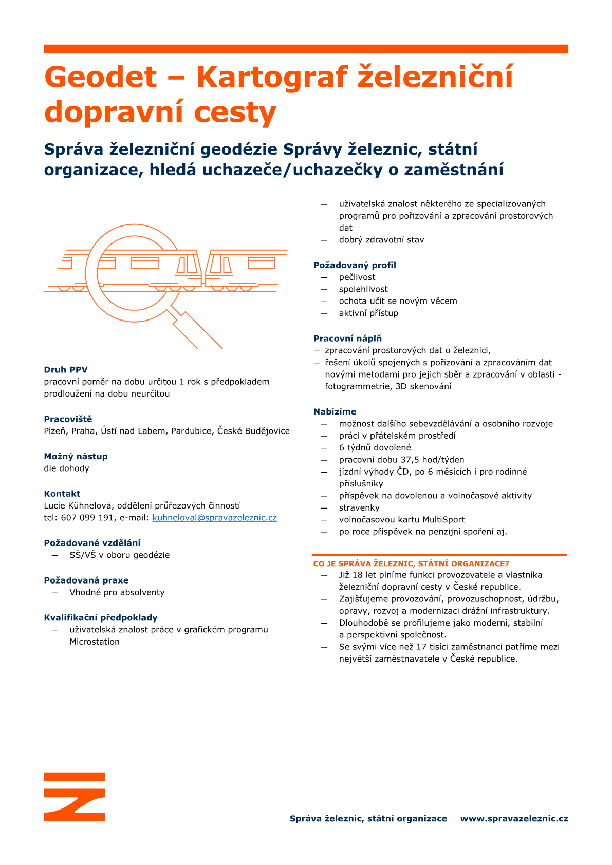
19.10.2021 15:05 ČÚZK /Urady/Cesky-urad-zememericky-a-katastralni/Uredni-deska/Oznameni-a-jina-uredni-sdeleni/Volna-mista/DMS/Odborny-referent-vrchni-referent-Podpora-uzivatePříležitost k zaměstnání: Geodet – Kartograf železniční dopravní cesty
19.10.2021 14:04 Blogující geomatici - FAV ZČUPodrobné informace v přiloženém obrázku.
Kontaktní osoba:
Lucie Kühnelová, oddělení průřezových činností
tel: 607 099 191, e-mail: kuhneloval@spravazeleznic.cz
Vyhlášení výběrového řízení: Referent/ka zeměměřictví a katastru nemovitostí
19.10.2021 14:01 Blogující geomatici - FAV ZČUDetailní popis tohoto výběrového řízení pro místo Referent/ka zeměměřictví a katastru nemovitostí v rámci Zeměměřického úřadu v Praze najdete na: https://www.cuzk.cz/getattachment/7536c59f-3bc8-4a37-9136-ddd08ce23cbe/Referent-ka-zememerictvi-a-katastru-nemovitosti-(1.aspx
Územní plánování v Česku je zdlouhavé. S pochopením návrhů pomůže veřejnosti využití mapových aplikací a 3D technologií (TZ)
19.10.2021 8:11 GISportal.cz
Územní plány jsou pro města a obce v Česku zásadními dokumenty, které ovlivňují budoucí směřování sídel na mnoho let dopředu. Jejich schvalování je zdlouhavým a náročným procesem a zejména laická veřejnost v množství různých dokumentů často tápe. S pochopením návrhů nových územních plánů a lepší orientaci v nich by mělo pomoci zapojení moderních technologií – využití mapových aplikací a […]
The post Územní plánování v Česku je zdlouhavé. S pochopením návrhů pomůže veřejnosti využití mapových aplikací a 3D technologií (TZ) appeared first on GISportal.cz.
Územní plánování v Česku je zdlouhavé. S pochopením návrhů pomůže veřejnosti využití mapových aplikací a 3D technologií (TZ)
19.10.2021 8:11 GISportal.czÚzemní plány jsou pro města a obce v Česku zásadními dokumenty, které ovlivňují budoucí směřování sídel na mnoho let dopředu. Jejich schvalování je zdlouhavým a náročným procesem a zejména laická veřejnost v množství různých dokumentů často tápe. S pochopením návrhů nových územních plánů a lepší orientaci v nich by mělo pomoci zapojení moderních technologií – využití mapových aplikací a […]
The post Územní plánování v Česku je zdlouhavé. S pochopením návrhů pomůže veřejnosti využití mapových aplikací a 3D technologií (TZ) appeared first on GISportal.cz.
Proven Drone-Based Automatic Dent Inspection Maps an Entire Rafale Fighter Jet in Just One Hour
18.10.2021 17:16 GISCafe.com Webcasts-Webinars Experience the flying dentCHECK at this year's MRO Europe in Amsterdam, booth #3080C and #9059.CONSTANCE, Germany and RANCHO CUCAMONGA, Calif., Oct. …
GeoComm Earns Esri Partner Network Release Ready Specialty Designation
18.10.2021 17:16 GISCafe.com Webcasts-Webinars GeoComm is pleased to announce their recognition by Esri as a Release Ready Specialty Esri Partner Network partner which is awarded to partners who …Aktualizovaný dokument Co přinesou digitální technické mapy obcím
18.10.2021 14:48 ČÚZK - předpisy a opatření Na stránce Informace pro obce byl zveřejněn aktualizovaný dokument "Co přinesou digitální technické mapy obcím a jaké jsou jejich povinnosti?"Volná místa v ZÚ – správa ZABAGED
18.10.2021 11:09 Česká kartografická společnost Zeměměřičský úřad hledá dva vysokoškoláky geografického/geodetického zaměření pro aktualizaci a rozvoj dat Základní báze geografických dat. Obě služební místa naleznete na vývěsce ZÚ pod názvem Referent zeměměřictví a katastru nemovitosti.Volná místa v ZÚ – správa ZABAGED
18.10.2021 11:09 Česká kartografická společnost Zeměměřičský úřad hledá dva vysokoškoláky geografického/geodetického zaměření pro aktualizaci a rozvoj dat Základní báze geografických dat. Více informací zde. Oficiální informace k obou místech a přihlášky naleznete na vývěsce ZÚ pod názvem Referent zeměměřictví a katastru nemovitosti.Nedostupné produkční prostředí ISÚI
18.10.2021 11:02 ČÚZK /ruian/Editacni-agendovy-system-ISUI/Provozni-informace-a-odstavky/Archiv-PROD/Nedostupne-produkcni-prostredi-ISUI-(24)Pracovní místa na Zeměměřickém úřadě
18.10.2021 10:41 Česká kartografická společnost Na Zeměměřickém úřadě hledají nové kolegy, a to konkrétně dva vysokoškoláky geografického/geodetického zaměření pro aktualizaci a rozvoj dat Základní báze geografických dat. Obě jsou služební místa pod názvem Referent zeměměřictví a katastru nemovitosti. Další volná pozice je také pro geografa/geografku s požadavkem na středoškolské vzdělání. Podrobnosti na webových stránkách.Volby 2021 v mapách
18.10.2021 9:38 ARCDATAVe spolupráci s politology Univerzity Palackého v Olomouci – Jakubem Lyskem a Tomášem Lebedou – jsme vytvořili soubor map shrnujících některá zajímavá fakta z letošních parlamentních voleb, a to zejména v porovnání s minulými volbami do poslanecké sněmovny v roce 2017. Můžete si tak například prohlédnout, jaká byla volební účast a jak výsledky voleb ovlivnila, nebo si porovnat zisky tří nejsilnějších stran (respektive koalic) s rokem 2017.
Volební analýzu najdete na adrese https://www.arcdata.cz/volby2021

"TCarta Dives Underwater to Provide Satellite-Derived Bathymetry" by Susan Smith
16.10.2021 15:05 GISCafe.com Webcasts-WebinarsDrone Nerds Is Now Offering the Emesent Hovermap Autonomous Mapper
15.10.2021 21:24 GISCafe.com Webcasts-Webinars Dania Beach, FLA., Oct. 15, 2021 (GLOBE NEWSWIRE) -- Drone Nerds, one of the largest North American drone solutions providers, has announced the …Fare gates on North South East West and Circle MRT lines to be replaced by July 2026
15.10.2021 20:37 Bentley SystemsPressCoverage
The Straits Times, Singapore
Read the articleAdvancing bridge inspection and asset management trough digital twin technology
15.10.2021 20:15 Bentley SystemsPressCoverage
ASPIRE Magazine, USA
Read the articleSpecialista GIS pro ZABAGED
15.10.2021 19:30 Katedra geoinformatiky UP OlomoucVolné pozice pro dva vysokoškoláky geografického/geodetického zaměření pro aktualizaci a rozvoj dat Základní báze geografických dat. Obě jsou služební místa pod názvem Referent zeměměřictví a katastru nemovitosti. Podrobnější informace naleznete na: https://www.cuzk.cz/Urady/Zememericky-urad/Volna-mista.aspx
The post Specialista GIS pro ZABAGED appeared first on Katedra geoinformatiky.
EUSPA-funded SIA project is nearing its completion with promising results for intelligent railway asset management
15.10.2021 14:23 European GNSS Agency providing prognostic information on the health status of the railway’s most demanding assets in terms of maintenance costs.")
Space based services will help reduce 15% of railway maintenance costs, 25% of maintenance unscheduled events and 15% of derailments associated with the rail-wheel interface. To tackle this challenge, the SIA consortium brings together multidisciplinary and cross sector partners (EGNSS technology providers, research centres, IT companies and railway stakeholders) that will co-design EGNSS solutions truly adapted to the needs of the rail sector.
Railway infrastructure and vehicle maintenance are estimated to cost over 25 billion Euros per year in Europe, and this figure is rising1 . The distribution of maintenance expenses varies in different countries and organizations. However, in relation to the railway infrastructure, track expenses represent between 40%-70% of the operational expenses, where the defects associated with the rails and catenary are the most significant (30% and 50% respectively). Other major maintenance costs relate to vehicle equipment such as the wheelset and pantograph (typically between 30%-50% and 5%-10% of the overall vehicle’s maintenance cost respectively). These figures are similar for all the infrastructure managers (IMs) and train operating companies (TOCs), which in total accounts for 330 organizations in the EU and 1500 organisations worldwide, therefore incurring over 8 billion Euros in recurrent expenses in the EU.
SIA project (System for vehicle-infrastructure Interaction Assets health status monitoring) has been funded by EUSPA since 2018 with the objective of developing four ready-to-use new services, to provide prognostic information about the health status of railways’ most demanding assets in terms of maintenance costs, at the points of the interaction between the vehicle and the infrastructure (wheelset, pantograph, rail, and catenary).
iCatMon is a service oriented towards IMs and maintenance subcontractors. The service provides information about the status of the overhead line (e.g. geometry of the Overhead Contact Wire - OCW).
iPantMon is intended for TOCs, providing information about the status of the pantograph during its interaction with the OCW (e.g. contact dynamics).
iWheelMon is also intended for TOCs, this service provides information about the health status of the wheelset (e.g. wheel diameter, out-of-roundness).
iRailMon is a service oriented towards IMs and maintenance subcontractors, the service provides information about defects on the rails (e.g. short-wave irregularities).
To enable these services, a modular system with all of the required components from vehicle sensor networks to KPI visualization for the end user has been developed. The value proposition of SIA is to develop these components in the most cost-effective way, i.e. with the use of cost-effective sensors and systems.
The SIA components include a sub-system for the recording of axle-box acceleration (ABA) data that can be related to defects in the track and wheelset. Another sub-system includes sensors that provide signals to characterize the interaction between the pantograph and catenary. EGNSS- based localization is performed, with real time processing of GNSS signals in multiple frequency bands including Galileo and map-supported refinement using Kalman filter methods in the back-office. A central datahub provides the onboard data management and communicates with the back-office part of SIA, for instance, to send events or detections in the monitoring data. The axle-box acceleration and pantograph data enriched with position information are further processed using component degradation models and analysis algorithms in the back-office. Finally, relevant asset key performance indicators (KPI) are displayed to the user in the visualization platform, with a rich functionality to illustrate the asset status and its evolution using different capabilities.
To validate the results, pilot tests have been carried out since October 2020 in three different scenarios: one of them coordinated by OBB (Österreichische Bundesbahnen), the Austrian operator, using both inspection vehicles and regular in-service trains throughout Austrian rail network; another scenario coordinated by VIAS, a Spanish maintenance subcontractor, using for the installation of the system a maintenance vehicle circulating over Madrid-Córdoba high-speed line; and the third scenario was coordinated by FGC (Ferrocarrils de la Generalitat de Catalunya), a Spanish regional TOC, using regular in-service trains throughout its whole network.
The results obtained so far are very promising. The aim is to validate the use of low-cost on-board systems to assess the health status of infrastructure and vehicle assets using the four developed services. Part of this success is due to the use of digital twins and AI technologies to extract health related KPIs. Some of the activities within the project contributed to the creation of a tech startup (MainRail Solutions), dedicated to the management of railway infrastructure. This start-up, created by Ceit and Inycom (linked third party of INGECONTROL) in 2020, has initiated its activities by deploying its first commercial references, e.g. tranvía Zaragoza (Spain) and SFM (Mallorca Railways, Spain) and PoC (Proof of Concept) pilots with other TOCs and IMs in Spain.
The implementation of the SIA system in regular service trains will enable a reduction in the costs associated with maintenance, while keeping the required levels of safety and service availability. The low-cost nature of the on-board equipment and the capabilities brought by the new services can potentially lead to reductions of 10% in the cost of the maintenance associated to the infrastructure’s assets, thanks to a reduction of unscheduled actions and MTTR (Mean Time To React).
Media note: This feature can be republished without charge provided the European Union Agency for the Space Programme (EUSPA) is acknowledged as the source at the top or the bottom of the story. You must request permission before you use any of the photographs on the site. If you republish, we would be grateful if you could link back to the EUSPA website (http://www.euspa.europa.eu).
- 1. Using analytics to get European rail maintenance on track, McKinsey & Company, 2020
EUSPA-funded SIA project is nearing its completion with promising results for intelligent railway asset management
15.10.2021 14:23 European GNSS AgencySpace based services will help reduce 15% of railway maintenance costs, 25% of maintenance unscheduled events and 15% of derailments associated with the rail-wheel interface. To tackle this challenge, the SIA consortium brings together multidisciplinary and cross sector partners (EGNSS technology providers, research centres, IT companies and railway stakeholders) that will co-design EGNSS solutions truly adapted to the needs of the rail sector.
Railway infrastructure and vehicle maintenance are estimated to cost over 25 billion Euros per year in Europe, and this figure is rising1 . The distribution of maintenance expenses varies in different countries and organizations. However, in relation to the railway infrastructure, track expenses represent between 40%-70% of the operational expenses, where the defects associated with the rails and catenary are the most significant (30% and 50% respectively). Other major maintenance costs relate to vehicle equipment such as the wheelset and pantograph (typically between 30%-50% and 5%-10% of the overall vehicle’s maintenance cost respectively). These figures are similar for all the infrastructure managers (IMs) and train operating companies (TOCs), which in total accounts for 330 organizations in the EU and 1500 organisations worldwide, therefore incurring over 8 billion Euros in recurrent expenses in the EU.
SIA project (System for vehicle-infrastructure Interaction Assets health status monitoring) has been funded by EUSPA since 2018 with the objective of developing four ready-to-use new services, to provide prognostic information about the health status of railways’ most demanding assets in terms of maintenance costs, at the points of the interaction between the vehicle and the infrastructure (wheelset, pantograph, rail, and catenary).
iCatMon is a service oriented towards IMs and maintenance subcontractors. The service provides information about the status of the overhead line (e.g. geometry of the Overhead Contact Wire - OCW).
iPantMon is intended for TOCs, providing information about the status of the pantograph during its interaction with the OCW (e.g. contact dynamics).
iWheelMon is also intended for TOCs, this service provides information about the health status of the wheelset (e.g. wheel diameter, out-of-roundness).
iRailMon is a service oriented towards IMs and maintenance subcontractors, the service provides information about defects on the rails (e.g. short-wave irregularities).
To enable these services, a modular system with all of the required components from vehicle sensor networks to KPI visualization for the end user has been developed. The value proposition of SIA is to develop these components in the most cost-effective way, i.e. with the use of cost-effective sensors and systems.
The SIA components include a sub-system for the recording of axle-box acceleration (ABA) data that can be related to defects in the track and wheelset. Another sub-system includes sensors that provide signals to characterize the interaction between the pantograph and catenary. EGNSS- based localization is performed, with real time processing of GNSS signals in multiple frequency bands including Galileo and map-supported refinement using Kalman filter methods in the back-office. A central datahub provides the onboard data management and communicates with the back-office part of SIA, for instance, to send events or detections in the monitoring data. The axle-box acceleration and pantograph data enriched with position information are further processed using component degradation models and analysis algorithms in the back-office. Finally, relevant asset key performance indicators (KPI) are displayed to the user in the visualization platform, with a rich functionality to illustrate the asset status and its evolution using different capabilities.
To validate the results, pilot tests have been carried out since October 2020 in three different scenarios: one of them coordinated by OBB (Österreichische Bundesbahnen), the Austrian operator, using both inspection vehicles and regular in-service trains throughout Austrian rail network; another scenario coordinated by VIAS, a Spanish maintenance subcontractor, using for the installation of the system a maintenance vehicle circulating over Madrid-Córdoba high-speed line; and the third scenario was coordinated by FGC (Ferrocarrils de la Generalitat de Catalunya), a Spanish regional TOC, using regular in-service trains throughout its whole network.
The results obtained so far are very promising. The aim is to validate the use of low-cost on-board systems to assess the health status of infrastructure and vehicle assets using the four developed services. Part of this success is due to the use of digital twins and AI technologies to extract health related KPIs. Some of the activities within the project contributed to the creation of a tech startup (MainRail Solutions), dedicated to the management of railway infrastructure. This start-up, created by Ceit and Inycom (linked third party of INGECONTROL) in 2020, has initiated its activities by deploying its first commercial references, e.g. tranvía Zaragoza (Spain) and SFM (Mallorca Railways, Spain) and PoC (Proof of Concept) pilots with other TOCs and IMs in Spain.
The implementation of the SIA system in regular service trains will enable a reduction in the costs associated with maintenance, while keeping the required levels of safety and service availability. The low-cost nature of the on-board equipment and the capabilities brought by the new services can potentially lead to reductions of 10% in the cost of the maintenance associated to the infrastructure’s assets, thanks to a reduction of unscheduled actions and MTTR (Mean Time To React).
Media note: This feature can be republished without charge provided the European Union Agency for the Space Programme (EUSPA) is acknowledged as the source at the top or the bottom of the story. You must request permission before you use any of the photographs on the site. If you republish, we would be grateful if you could link back to the EUSPA website (http://www.euspa.europa.eu).
- 1. Using analytics to get European rail maintenance on track, McKinsey & Company, 2020