


![]()

zprávy
zdroje zpráv:20210106 - Standard pro kontroly přenesené působnosti
10.6.2021 14:27 ČÚZK /ruian/Novinky-RUIAN/Archiv-novinek-RUIAN/2021/20210106-Standard-pro-kontroly-prenesene-pusobno20210106 - Standard pro kontroly přenesené působnosti
10.6.2021 14:27 ČÚZK - předpisy a opatření V sekci 5. Metodika/Kontroly přenesené působnosti byl zveřejněn nový soubor dokumentů Standard pro oblast kontroly zápisu údajů do ISÚI/RÚIAN, který je určen krajským úřadům, Magistrátu hlavního města Prahy a magistrátům územně členěných statutárních měst při provádění kontrol přenesené působnosti na úseku RÚIAN, a který nahrazuje dosavadní "Metodické doporučení v oblasti kontroly přenesené působnosti".20201130 - Nová verze Aplikace pro kontroly dat RÚIAN
10.6.2021 14:15 ČÚZK - předpisy a opatření Dne 30. 11. 2020 byla vystavena nová verze Aplikace pro kontroly dat RÚIAN, rozšířená o statistiky za kraj. V případě problémů se zobrazením stránky použijte Ctrl+F5 pro aktualizaci stránky.20201130 - Nová verze Aplikace pro kontroly dat RÚIAN
10.6.2021 14:15 ČÚZK /ruian/Novinky-RUIAN/Archiv-novinek-RUIAN/2020/20201130-Nova-verze-Aplikace-pro-kontroly-dat-RU20210119 - opatření proti vytěžování VDP
10.6.2021 14:12 ČÚZK /ruian/Novinky-RUIAN/Archiv-novinek-RUIAN/2021/20210119-opatreni-proti-vytezovani-VDP20210119 - opatření proti vytěžování VDP
10.6.2021 14:12 ČÚZK - předpisy a opatřeníVzhledem k opakovanému vytěžování VDP, které je v rozporu s podmínkami užívání aplikace, pro získání přístupu do Nahlížení do KN jsme byli nuceni upravit rozhraní aplikací. Ve VDP je nyní možné zobrazit údaje o vlastnictví až po potvrzení akce v dialogovém okně.
Nedostupnost Národního geoportálu INSPIRE
10.6.2021 13:40 CENIA - národní geoportál INSPIRE Z důvodu plánované údržby síťové infrastruktury Ministerstva životního prostředí budou ve středu 16. 6. 2021 od 17:00 do 21:00 dočasně nedostupné webové stránky Národního geoportálu INSPIRE. Děkujeme za pochopení.Děčín spouští elektronický stavební deník STAVEE
10.6.2021 13:30 Hrdlička Stavební firmy budou muset u všech městských staveb vést elektronický deník.Geodeti z firmy Grid měřili dno Vltavy
10.6.2021 13:18 ZeměměřičŘeditelství vodních cest ČR a Státní fond dopravní infrastruktury se rozhodly pro zvýšení ponorů na Vltavské vodní cestě. V současné době se na úseku Mělník – Praha Radotín nachází pouze několik míst s lokálním výskytem mělčin, které omezují využitelný ponor plavidel jen na 1,80 m. Pro dosažení ponoru srovnatelného s Labskou vodní cestou, tj. 2,20 m, není nutné souvislé prohloubení celé […]
The post Geodeti z firmy Grid měřili dno Vltavy appeared first on Zeměměřič.
Four mission ideas to compete for Earth Explorer 11
10.6.2021 12:20 ESA Observing the Earth
As part of ESA’s commitment to develop and build satellite missions that push the boundaries of satellite technology and Earth science, four new mission ideas – Cairt, Nitrosat, Seastar and Wivern – have been selected to enter pre-feasibility study and compete to be the eleventh Earth Explorer mission.
Forest degradation primary driver of carbon loss in the Brazilian Amazon
10.6.2021 11:00 ESA Observing the Earth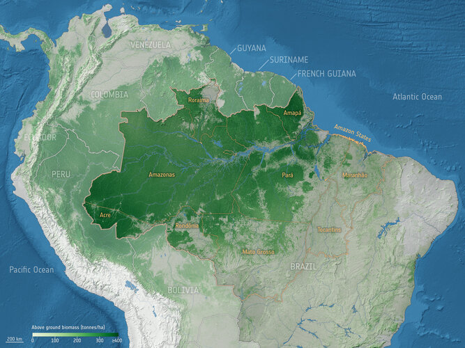
Forest degradation has become the largest process driving carbon loss in the Brazilian Amazon, according to a recent study using ESA satellite data.
Kniha Aretinova mapa Českého království [Katedra aplikované geoinformatiky a kartografie, byTopic]
10.6.2021 10:25 Katedra aplikované geoinformatiky a kartografie Přf UK V těchto dnech vychází v rámci edice Monumenta Cartographica Bohemiae kolektivní monografie věnovaná životu a dílu Pavla Aretina z Ehrenfeldu, jehož mapa Českého království byla poprvé publikována roku 1619.Chytré zemědělství. Konference o příležitostech pro spolupráci
10.6.2021 9:59 GeoBusinessAkce chce seznámit české a bulharské výzkumné organizace, společnosti a také veřejnost, které se zabývají problematikou chytrého zemědělství, s příležitostmi pro spolupráci na úseku výzkumu a vývoje nových technologií a produktů pro chytré zemědělství a pro položení základů komunikace mezi českými a bulharskými výzkumnými organizacemi a firmami, jež se zabývají chytrým zemědělstvím. Jedná se o […]
The post Chytré zemědělství. Konference o příležitostech pro spolupráci appeared first on GeoBusiness.
Arctic coastal sea ice thinning twice as fast than thought
10.6.2021 9:10 ESA Observing the Earth
Research based on ice-thickness data from ESA’s CryoSat and Envisat missions along with a new model of snow has revealed that sea ice in the coastal regions of the Arctic may be thinning twice as fast as thought.
20210610 - Navýšení počtu vrcholů ohrady pro export VFK
10.6.2021 9:09 ČÚZK - Výměnný formát ISKN V souvislosti s květnovou instalací nové verze ISKN 9.1.1 byl navýšen počet vrcholů ohrady pro zadání exportu VFK. Nově je možné zadávat polygon s maximálně 4000 vrcholy. Rozšíření maximálního počtu vrcholů se netýká exportů zadaných prostřednictvím WSGP.20210610 - Navýšení počtu vrcholů ohrady pro export VFK
10.6.2021 9:09 ČÚZK - předpisy a opatřeníV souvislosti s květnovou instalací nové verze ISKN 9.1.1 byl navýšen počet vrcholů ohrady pro zadání exportu VFK. Nově je možné zadávat polygon s maximálně 4000 vrcholy. Rozšíření maximálního počtu vrcholů se netýká exportů zadaných prostřednictvím WSGP.
20210610 - Navýšení počtu vrcholů ohrady pro export VFK
10.6.2021 9:09 ČÚZK - Výměnný formát ISKN V souvislosti s květnovou instalací nové verze ISKN 9.1.1 byl navýšen počet vrcholů ohrady pro zadání exportu VFK. Nově je možné zadávat polygon s maximálně 4000 vrcholy. Rozšíření maximálního počtu vrcholů se netýká exportů zadaných prostřednictvím WSGP.Česko-bulharská konference o zavádění chytrého zemědělství (TZ)
10.6.2021 8:54 GISportal.czCílem akce bude seznámit české a bulharské výzkumné organizace, společnosti a také veřejnost, které se zabývají problematikou chytrého zemědělství, s příležitostmi pro spolupráci na úseku výzkumu a vývoje nových technologií a produktů pro chytré zemědělství a pro položení základů komunikace mezi českými a bulharskými výzkumnými organizacemi a firmami, jež se zabývají chytrým zemědělstvím. Jedná se […]
The post Česko-bulharská konference o zavádění chytrého zemědělství (TZ) appeared first on GISportal.cz.
20210611 - volné místo - Rada/odborný rada v OMaK kanceláře ředitele KÚ na KÚ pro Ústecký kraj
10.6.2021 8:35 ČÚZK /Urady/Katastralni-urady/Katastralni-urady/Katastralni-urad-pro-Ustecky-kraj/O-uradu/Aktuality/20210611-volne-misto-Rada-odborny-rada-v-OMaK-(1)20210611 - volné místo - Rada/odborný rada v OMaK kanceláře ředitele KÚ na KÚ pro Ústecký kraj
10.6.2021 8:35 ČÚZK - předpisy a opatření Katastrální úřad pro Ústecký kraj zveřejnil novou aktualitu: Nabídka volného místa - Rada / odborný rada v oddělení metodiky a kontroly v kanceláři ředitele katastrálního úřadu na Katastrálním úřadu pro Ústecký kraj20210611 - volné místo - Rada/odborný rada v OMaK kanceláře ředitele KÚ na KÚ pro Ústecký kraj
10.6.2021 8:35 ČÚZK - předpisy a opatření Katastrální úřad pro Ústecký kraj zveřejnil novou aktualitu: Nabídka volného pracovníého místa - Rada / odborný rada v oddělení metodiky a kontroly v kanceláři ředitele katastrálního úřadu na Katastrálním úřadu pro Ústecký krajRada / odborný rada v oddělení metodiky a kontroly v kanceláři ředitele katastrálního úřadu na Katas
10.6.2021 8:32 ČÚZK /Urady/Katastralni-urady/Katastralni-urady/Katastralni-urad-pro-Ustecky-kraj/Uredni-deska/Oznameni-a-jina-uredni-sdeleni/Volna-mista/DMS/Rada-odborny-rada-v-oddeleni-metodiky-a-kontro-(1)Rada / odborný rada v oddělení metodiky a kontroly v kanceláři ředitele katastrálního úřadu na Katas
10.6.2021 8:32 ČÚZK - předpisy a opatření Katastrální úřad pro Ústecký kraj kancelář ředitelevypisuje výběrové řízení na místo
Rada / odborný rada v oddělení metodiky a kontroly v kanceláři ředitele katastrálního úřadu na Katastrálním úřadu pro Ústecký kraj
Rada / odborný rada v oddělení metodiky a kontroly v kanceláři ředitele katastrálního úřadu na Katas
10.6.2021 8:32 ČÚZK - volná místa Katastrální úřad pro Ústecký kraj kancelář ředitele vypisuje výběrové řízení na místo Rada / odborný rada v oddělení metodiky a kontroly v kanceláři ředitele katastrálního úřadu na Katas20210611 - volné místo - Rada/odborný rada v OMaK kanceláře ředitele KÚ na KÚ pro Ústecký kraj
10.6.2021 8:09 ČÚZK - předpisy a opatření Katastrální úřad pro Ústecký kraj zveřejnil novou aktualitu: Nabídka volného místa - Rada / odborný rada v oddělení metodiky a kontroly kanceláře ředitele katastrálního úřadu na Katastrálním úřadu pro Ústecký kraj20210611 - volné místo - Rada/odborný rada v OMaK kanceláře ředitele KÚ na KÚ pro Ústecký kraj
10.6.2021 8:09 ČÚZK /Urady/Katastralni-urady/Katastralni-urady/Katastralni-urad-pro-Ustecky-kraj/O-uradu/Aktuality/20210611-volne-misto-Rada-odborny-rada-v-OMaKRada / odborný rada v oddělení metodiky a kontroly v kanceláři ředitele katastrálního úřadu na Katas
10.6.2021 8:04 ČÚZK /Urady/Katastralni-urady/Katastralni-urady/Katastralni-urad-pro-Ustecky-kraj/Uredni-deska/Oznameni-a-jina-uredni-sdeleni/Volna-mista/DMS/Rada-odborny-rada-v-oddeleni-metodiky-a-kontrolyRada / odborný rada v oddělení metodiky a kontroly v kanceláři ředitele katastrálního úřadu na Katas
10.6.2021 8:04 ČÚZK - předpisy a opatření Katastrální úřad pro Ústecký krajvypisuje výběrové řízení na místo
Rada / odborný rada v oddělení metodiky a kontroly v kanceláři ředitele katastrálního úřadu na Katastrálním úřadu pro Ústecký kraj
Rada / odborný rada v oddělení metodiky a kontroly v kanceláři ředitele katastrálního úřadu na Katas
10.6.2021 8:04 ČÚZK - volná místa Katastrální úřad pro Ústecký kraj vypisuje výběrové řízení na místo Rada / odborný rada v oddělení metodiky a kontroly v kanceláři ředitele katastrálního úřadu na Katas20210611 - volné místo - Vedoucí OMaK v kanceláři ředitele KÚ na KÚ pro Ústecký kraj
10.6.2021 7:55 ČÚZK - předpisy a opatření Katastrální úřad pro Ústecký kraj zveřejnil novou aktualitu: Nabídka volného místa - Vedoucí oddělení metodiky a kontroly v kanceláři ředitele katastrálního úřadu na Katastrálním úřadu pro Ústecký kraj20210611 - volné místo - Vedoucí OMaK v kanceláři ředitele KÚ na KÚ pro Ústecký kraj
10.6.2021 7:55 ČÚZK /Urady/Katastralni-urady/Katastralni-urady/Katastralni-urad-pro-Ustecky-kraj/O-uradu/Aktuality/20210611-volne-misto-Vedouci-OMaK-v kancelariVedoucí oddělení metodiky a kontroly v kanceláři ředitele katastrálního úřadu na Katastrálním úřadu
10.6.2021 7:43 ČÚZK - předpisy a opatření Katastrální úřad pro Ústecký kraj kancelář ředitelevypisuje výběrové řízení na místo
Vedoucí oddělení metodiky a kontroly v kanceláři ředitele katastrálního úřadu na Katastrálním úřadu pro Ústecký kraj
Vedoucí oddělení metodiky a kontroly v kanceláři ředitele katastrálního úřadu na Katastrálním úřadu
10.6.2021 7:43 ČÚZK - volná místa Katastrální úřad pro Ústecký kraj kancelář ředitele vypisuje výběrové řízení na místo Vedoucí oddělení metodiky a kontroly v kanceláři ředitele katastrálního úřadu na Katastrálním úřaduVedoucí oddělení metodiky a kontroly v kanceláři ředitele katastrálního úřadu na Katastrálním úřadu
10.6.2021 7:43 ČÚZK /Urady/Katastralni-urady/Katastralni-urady/Katastralni-urad-pro-Ustecky-kraj/Uredni-deska/Oznameni-a-jina-uredni-sdeleni/Volna-mista/DMS/Vedouci-oddeleni-metodiky-a-kontroly-v kancelari-rGetech Multi-Sat 2020 Ushers in a New Era of Gravity Resolution
10.6.2021 1:07 GISCafe.com Webcasts-Webinars Getech Group has released Multi-Sat 2020 to provide explorers with the highest accuracy and resolution altimetry-derived gravity data …Matterport Launches Program for Partners to Build and Commercialize Apps and Integrations on its Spatial Data Platform
10.6.2021 1:07 GISCafe.com Webcasts-Webinars Company expands its global reach across industries by empowering an ecosystem of developers and industry partners with its new Platform Partner …Informace k předběžné tržní konzultaci na poskytování datových služeb pro Státní pozemkový úřad
10.6.2021 0:00 Státní pozemkový úřad Praha, 10. června 2021 – Státní pozemkový úřad se jako zadavatel rozhodl využít institutu PTK dle ust. § 33 zákona č. 134/2016 Sb., ve znění pozdějších předpisů, o zadávání veřejných zakázek (dále jen „zákon“), jako nástroje ke komunikaci s dodavateli, a to za účelem zjištění relevantních a objektivních informací o možnostech trhu v oblasti poskytování datových služeb.Informace k předběžné tržní konzultaci na poskytování datových služeb pro Státní pozemkový úřad
10.6.2021 0:00 Státní pozemkový úřad Praha, 10. června 2021 – Státní pozemkový úřad se jako zadavatel rozhodl využít institutu PTK dle ust. § 33 zákona č. 134/2016 Sb., ve znění pozdějších předpisů, o zadávání veřejných zakázek (dále jen „zákon“), jako nástroje ke komunikaci s dodavateli, a to za účelem zjištění relevantních a objektivních informací o možnostech trhu v oblasti poskytování datových služeb.Informace k předběžné tržní konzultaci na poskytování datových služeb pro Státní pozemkový úřad
10.6.2021 0:00 Státní pozemkový úřad Praha - 10. června 2021 - Česká republika – Státní pozemkový úřad se jako zadavatel rozhodl využít institutu PTK dle ust. § 33 zákona č. 134/2016 Sb., ve znění pozdějších předpisů, o zadávání veřejných zakázek (dále jen „zákon“), jako nástroje ke komunikaci s dodavateli, a to za účelem zjištění relevantních a objektivních informací o možnostech trhu v oblasti poskytování datových služeb.Informace k předběžné tržní konzultaci na poskytování datových služeb pro Státní pozemkový úřad
10.6.2021 0:00 Státní pozemkový úřad Praha - 10. června 2021 - Česká republika – Státní pozemkový úřad se jako zadavatel rozhodl využít institutu PTK dle ust. § 33 zákona č. 134/2016 Sb., ve znění pozdějších předpisů, o zadávání veřejných zakázek (dále jen „zákon“), jako nástroje ke komunikaci s dodavateli, a to za účelem zjištění relevantních a objektivních informací o možnostech trhu v oblasti poskytování datových služeb.Sdružení Open Geospatial připravilo testování pro formát GeoTIFF 1.1
9.6.2021 18:19 GeoBusinessSdružení Open Geospatial (OGC) oznámilo, že je k dispozici validační nástroj pro formát GeoTIFF 1.1. Tvůrci softwarů mohou k ověření svých produktů nahrát geotiffový soubor, vytvořený jejich softwarem. Jakmile produkt projde testem, může tvůrce odeslat žádost o použití ochranné známky OGC v souladu se svým produktem. Standard pro OGC GeoTIFF 1.1 definuje požadavky na formát […]
The post Sdružení Open Geospatial připravilo testování pro formát GeoTIFF 1.1 appeared first on GeoBusiness.
Aretinova mapa Českého království: Monografie o Pavlu Aretinovi z Ehrenfeldu
9.6.2021 17:58 ZeměměřičNakladatelství Karolinum vydává monografii, která seznamuje s životem a dílem pobělohorského exulanta Pavla Aretina z Ehrenfeldu. Kniha představuje život a dílo Pavla Aretina z Ehrenfeldu, jehož mapa Nový a přesný popis Království českého vyšla poprvé roku 1619 (další vydání 1632, 1665, před 1747) a vzhledem k válečnému použití se dochovala ve velmi málo kopiích. Autoři v publikaci poprvé identifikují a srovnávají toponyma z rejstříků všech vydání. […]
The post Aretinova mapa Českého království: Monografie o Pavlu Aretinovi z Ehrenfeldu appeared first on Zeměměřič.
Sentera Secures $25 Million Series C Funding to Accelerate the Delivery of AI-Powered Decision Support for Food and Agriculture
9.6.2021 17:56 GISCafe.com Webcasts-Webinars Investment enhances the company's position as a provider of time sensitive insights that optimize decisions and improve outcomes for stakeholders …National Broadband Ireland Selects GE Digital’s Smallworld Physical Network Inventory to Help with the Roll Out of High-Speed Broadband Across Rural Ireland
9.6.2021 17:09 GISCafe.com Webcasts-Webinars Ireland’s National Broadband Plan delivers high-speed broadband service to support communications, information, education, and entertainment to …Marietta Group Extends Inspection Capabilities with Drone and Artificial Intelligence Technology
9.6.2021 17:09 GISCafe.com Webcasts-Webinars MARIETTA, Ohio — (BUSINESS WIRE) — June 9, 2021 —Marietta Group has introduced a new supplemental inspection capability that uses …
HawkEye 360 Increases Analytic Capabilities to Combat Illegal Fishing
9.6.2021 15:21 GISCafe.com Webcasts-Webinars SEAker analytics provide timely global insights into maritime activityHERNDON, Va., June 9, 2021 — (PRNewswire) — HawkEye 360 Inc., the …
Panzura CEO Jill Stelfox Accepted into Forbes Business Council
9.6.2021 15:21 GISCafe.com Webcasts-Webinars Stelfox Brings Two Decades of Technology Industry Influence and Leadership to Esteemed Invitation-Only Global Business CommunitySAN JOSE, Calif., …
Měření světelného smogu z letadla
9.6.2021 15:13 TopGis V polovině dubna jsme se zúčastnili ojedinělého experimentu, kdy město Brno zkoumalo míru světelného smogu, které způsobují různé světelné zdroje. Technické sítě Brno vypnuly krátce po půlnoci přes 40 000 lamp veřejného osvětlení a kromě pozemního měření následovalo i noční letecké snímkování. Data pořízená na ploše 292 kilometrů čtverečních ukázala, že vypnuté veřejné osvětlení snížilorada/odborný rada – rozhodování o povolení vkladu v oddělení právních vztahů k nemovitostem Katastrá
9.6.2021 14:56 ČÚZK - předpisy a opatření Katastrální úřad pro Jihočeský kraj Katastrální pracoviště Jindřichův Hradecvypisuje výběrové řízení na místo
rada/odborný rada – rozhodování o povolení vkladu v oddělení právních vztahů k nemovitostem Katastrálního pracoviště Jindřichův Hradec (ID SM 30000179/30003803)
rada/odborný rada – rozhodování o povolení vkladu v oddělení právních vztahů k nemovitostem Katastrá
9.6.2021 14:56 ČÚZK - volná místa Katastrální úřad pro Jihočeský kraj Katastrální pracoviště Jindřichův Hradec vypisuje výběrové řízení na místo rada/odborný rada – rozhodování o povolení vkladu v oddělení právních vztahů k nemovitostem KatastráJak bylo na Esri Developer Summit
9.6.2021 14:35 blog ARCDATA Esri Developer Summit je konference zaměřená na technickou stránku technologií ArcGIS. Letos se konala virtuálně ve dnech 6. až 8. dubna a v naší reportáži vám přinášíme to nejzajímavější, s čím se naši kolegové během konference setkali.EU Space Programme Launch Event: June 22 - Save the Date!
9.6.2021 12:40 European GNSS Agency
The launch of the European Union Space Programme and its entry into force will be celebrated at a special online event to be held on June 22. The event will focus on how the Space programme marks a fresh start to an ambitious Space Agenda for Europe and showcase the contribution of the EU Space Programme to Europe’s digital and green transitions and the EU’s priority policies. For more information and to register, click here.
The event, which takes place from 09:30 to 13:00 on June 22, features high-level decision-makers and round table sessions discussing pressing issues such as cooperation amongst the space actors, entrepreneurship opportunities, and how the EU Space Programme contributes to various EU policies.
The event will open with statements from European Commissioner for the Internal Market Thierry Breton, Portuguese Minister for Science, Technology and Higher Education Manuel Heitor and MEP Cristian Busoi on the entry into force of the new Regulation. This will be followed by the formal signing of the Financial Framework Partnership Agreement.
Meeting with the press
A press event will start with Commissioner Breton statement. European Union Agency for the Space Programme (EUSPA) Executive Director Rodrigo da Costa, European Commission Director-General for Industry and Space Timo Pesonen and ESA Director General will give the media an opportunity to have their questions answered.
The EUSPA Executive Director and the DG DEFIS Director General will then participate in a session on successful cooperation within the EU Space Programme, along with MEP Massimiliano Salini and European Space Agency Director General Josef Aschbacher.
Read this: CASSINI hackathon leverages space to digitise green spaces
The event will end with a session on how the EU Space Programme is enabling EU policies and supporting EU entrepreneurship, with participation by Ekaterini Kavvada from DG DEFIS, EUSPA Head of Market Development Fiammetta Diani and European Centre for Medium-Range Weather Forecasts (ECMWF) Director General Florence Rabier.
The conference is co-hosted by the European Commission/DG DEFIS, the European Union Agency for the Space Programme (EUSPA) and the European Space Agency (ESA).
Some background
On 6 June 2018, the European Commission presented the new Space Programme for the period 2021-2027. The aim of the Programme is to ensure investment continuity in EU space activities, encourage scientific and technical progress and support the competitiveness and innovation capacity of the European space industry.
And this: Going green? Look to EU Space!
On April 28 this year, the European Parliament confirmed the political agreement on the Space Regulation reached in December 2020, officially creating the European Union Agency for the Space Programme. The EU Space Programme has the largest budget ever for space - €14.88 billion. The Space Programme brings all EU space activities under one roof and will enable space to contribute effectively to the priorities of the European agenda.
Media note: This feature can be republished without charge provided the European Union Agency for the Space Programme (EUSPA) is acknowledged as the source at the top or the bottom of the story. You must request permission before you use any of the photographs on the site. If you republish, we would be grateful if you could link back to the EUSPA website (http://www.euspa.europa.eu).
EU Space Programme Launch Event: June 22 - Save the Date!
9.6.2021 12:40 European GNSS Agency
The launch of the European Union Space Programme and its entry into force will be celebrated at a special online event to be held on June 22. The event will focus on how the Space programme marks a fresh start to an ambitious Space Agenda for Europe and showcases the contribution of the EU Space Programme to Europe’s digital and green transitions and the EU’s priority policies. For more information and to register, click here.
The event, which takes place from 09:30 to 13:00 on June 22, features high-level decision-makers and round table sessions discussing pressing issues such as cooperation amongst the space actors, entrepreneurship opportunities, and how the EU Space Programme contributes to various EU policies.
The event will open with statements from European Commissioner for the Internal Market Thierry Breton, Portuguese Minister for Science, Technology and Higher Education Manuel Heitor and MEP Cristian Busoi on the entry into force of the new Regulation. This will be followed by the formal signing of the Financial Framework Partnership Agreement.
Meeting with the press
A press event will start with Commissioner Breton statement. European Union Agency for the Space Programme (EUSPA) Executive Director Rodrigo da Costa, European Commission Director-General for Industry and Space Timo Pesonen and ESA Director General will give the media an opportunity to have their questions answered.
The EUSPA Executive Director and the DG DEFIS Director General will then participate in a session on successful cooperation within the EU Space Programme, along with MEP Massimiliano Salini and European Space Agency Director General Josef Aschbacher.
Read this: CASSINI hackathon leverages space to digitise green spaces
The event will end with a session on how the EU Space Programme is enabling EU policies and supporting EU entrepreneurship, with participation by Ekaterini Kavvada from DG DEFIS, EUSPA Head of Market Development Fiammetta Diani and European Centre for Medium-Range Weather Forecasts (ECMWF) Director General Florence Rabier.
The conference is co-hosted by the European Commission/DG DEFIS, the European Union Agency for the Space Programme (EUSPA) and the European Space Agency (ESA).
Some background
On 6 June 2018, the European Commission presented the new Space Programme for the period 2021-2027. The aim of the Programme is to ensure investment continuity in EU space activities, encourage scientific and technical progress and support the competitiveness and innovation capacity of the European space industry.
And this: Going green? Look to EU Space!
On April 28 this year, the European Parliament confirmed the political agreement on the Space Regulation reached in December 2020, officially creating the European Union Agency for the Space Programme. The EU Space Programme has the largest budget ever for space - €14.88 billion. The Space Programme brings all EU space activities under one roof and will enable space to contribute effectively to the priorities of the European agenda.
Media note: This feature can be republished without charge provided the European Union Agency for the Space Programme (EUSPA) is acknowledged as the source at the top or the bottom of the story. You must request permission before you use any of the photographs on the site. If you republish, we would be grateful if you could link back to the EUSPA website (http://www.euspa.europa.eu).
Geoinformatický Executive Briefing 2021
9.6.2021 11:25 Unicorn Již zítra 10. června od 9:30 pořádáme geoinformatický Executive Briefing! Seznámíme vás například s novinkami v technologiích Esri, představíme vám naše řešení nebo se podělíme o zkušenosti z oboru. Součástí programu bude i virtuální tombola, ve které můžete vyhrát zajímavé ceny. Připojte se k nám, budeme se těšit.Významné mezinárodní ocenění pro Jacka Dangermonda
9.6.2021 11:21 T-MAPYThe post Významné mezinárodní ocenění pro Jacka Dangermonda appeared first on T-MAPY spol. s r.o..
Unicorn zrealizoval systém JES pro společnost RWE Gas Storage
9.6.2021 11:15 Unicorn Unicorn úspěšně dokončil implementaci systému JES, který vytvořil pro společnost RWE Gas Storage. Jedná se o systém, který klient nyní využívá jako efektivní nástroj pro sjednocení agend v oblasti geoscience. Systém JES pomáhá klientovi zefektivnit dlouhodobý provoz podzemních zásobníků zemního plynu.SatRevolution Selects SkyWatch TerraStream to Deliver Data Management Capabilities to Upcoming STORK Mission
9.6.2021 9:00 GISCafe.com Webcasts-Webinars Waterloo, Ontario, Canada — June 9, 2021 — SkyWatch Space Applications Inc. ("SkyWatch"), a Waterloo-based space technology startup, …Diskuze: Datově orientovaná veřejná správa
9.6.2021 7:59 GeoBusinessSoučástí online konference ISSS.online byla také panelová diskuze o používání dat ve veřejné správě. Veřejná správa má velké množství dat, se kterými pracuje rozhodně méně, než by mohla, protože rozhodování ve veřejné správě probíhá ne vždy na základě „tvrdých dat“. Příkladů z poslední doby kritizovaných odborně i mediálně najde každý z nás mnoho. Práce s […]
The post Diskuze: Datově orientovaná veřejná správa appeared first on GeoBusiness.
Letní uzavření knihovny [Knihovna geografie, byTopic]
9.6.2021 0:00 Katedra aplikované geoinformatiky a kartografie Přf UK Od 19. 7. do 31.8. 2021 bude Knihovna geografie PřF UK uzavřena pro veřejnost a neposkytuje žádné služby. Probíhají zde rekonstrukce a v srpnu přechází celá Univerzita Karlova na nový knihovní systém Alma od izraelské firmy Ex Libris. Systém nebude dostupný zřejmě do počátku září. Své výpůjčky si tedy zajistěte včas! Vracení knih bude možné do boxu v chodbě.Letní uzavření knihovny [Knihovna geografie, byTopic]
9.6.2021 0:00 Katedra aplikované geoinformatiky a kartografie Přf UK Od 19. 7. do 31.8. 2021 je Knihovna geografie PřF UK uzavřena pro veřejnost a neposkytuje žádné služby. Probíhají zde rekonstrukce podlah a světel v hlavních sálech. V srpnu přechází celá Univerzita Karlova na nový knihovní systém Alma od izraelské firmy Ex Libris. Systém nebude dostupný do počátku září. Své výpůjčky si tedy zajistěte včas! Vracení knih bude možné do biblioboxu na chodbě.Citadel Defense Secures New San Diego Headquarters as Growth Accelerates
8.6.2021 17:28 GISCafe.com Webcasts-Webinars Citadel’s Innovation Campus will have an AI-Center of Excellence, UAS garage, production line and moreSAN DIEGO — (BUSINESS WIRE) — …
DarkPulse, Inc. Announces Letters of Intent to Acquire Both Drone Based A.I. Companies, Remote Intelligence and Wildlife Specialists
8.6.2021 17:28 GISCafe.com Webcasts-Webinars NEW YORK, June 08, 2021 (GLOBE NEWSWIRE) -- Dark Pulse, Inc. (OTC Markets: DPLS) (“DarkPulse” and the “Company”), a technology company …Genesis Selects TomTom Maps and Traffic to Power Models in Europe
8.6.2021 16:24 GISCafe.com Webcasts-Webinars Genesis will start using TomTom’s maps and real-time traffic service across its European line up from 2021Genesis G80 and GV80 will become first …Hexagon introduces HxGN Connect, a SaaS workspace enabling seamless, citywide collaboration, planning and response
8.6.2021 16:23 GISCafe.com Webcasts-Webinars NACKA STRAND, Sweden, June 8, 2021 — (PRNewswire) — Hexagon AB, a global leader in sensor, software and autonomous solutions, today …Building a foundational map of humanity using machine learning
8.6.2021 16:23 GISCafe.com Webcasts-Webinars WASHINGTON, D.C, June 7, 2021 — (PRNewswire) — Geospatial data and analytics company Fraym announced a Series B financing to further …CoreLogic Reports Strong Improvement for US Mortgage Delinquency Rates in March
8.6.2021 16:23 GISCafe.com Webcasts-Webinars One-year since the onset of the pandemic, the U.S. overall delinquency hits lowest levelIRVINE, Calif. — (BUSINESS WIRE) — June 8, 2021 …
Cupix Launches CupixWorks 2.0 3D Digital Twin Platform as Company Expands Footprint in North American Market
8.6.2021 16:23 GISCafe.com Webcasts-Webinars Enhanced Platform Gives AEC Sector and Building Owners New Tools for Building SmarterSAN JOSE, Calif. — (BUSINESS WIRE) — June 8, 2021 …
Measure, an AgEagle Company, and Parrot Complete Integration of Ground Control with ANAFI Drone Platforms
8.6.2021 16:23 GISCafe.com Webcasts-Webinars WICHITA, Kan., June 08, 2021 (GLOBE NEWSWIRE) -- AgEagle™ Aerial Systems Inc. (NYSE American: UAVS) (“AgEagle” or the “Company”), an …Edw. C Levy Modernizes Data Collection and Improves Inventory Management with Kespry
8.6.2021 16:23 GISCafe.com Webcasts-Webinars Leading construction, aggregates, and facilities company leveraging Kespry's Aerial Intelligence platform to vastly improve worker safety, …WWC Global Awarded $82 Million U.S. Agency for International Development (USAID) Contract
8.6.2021 16:23 GISCafe.com Webcasts-Webinars Woman-Owned Firm will Support the Office of Transition Initiatives (OTI)TAMPA, Fla., June 8, 2021 — (PRNewswire) — WWC Global, a …
ResponDrone Adds 3D Mapping Abilities to Provide First Responders with Near Real-Time Data
8.6.2021 16:23 GISCafe.com Webcasts-Webinars ResponDrone's situation awareness system now includes precision mapping abilities to enable rescue teams to better understand their working …Cron AI Partners with Innoviz to Deliver LiDAR-based Adaptive Perception Software for Smart Cities
8.6.2021 16:23 GISCafe.com Webcasts-Webinars DERBY, England and TEL AVIV, Israel, June 8, 2021 — (PRNewswire) — Adaptive 3D edge perception platform company Cron AI and Innoviz …Satellites and the sea
8.6.2021 15:57 European GNSS Agency
On World Ocean Day, which takes place every year on 8 June, people around the world celebrate our shared ocean and take action to protect and restore it for future generations. Today we take a look at how EU Space contributes to these efforts by providing data that improves our understanding of the ocean ecosystem and enables applications and services that help to minimise the impact of human activity on ocean health.
The 2020 EU Blue Economy Report tells us that a sustainable Blue Economy allows society to obtain value from the oceans and coastal regions, while respecting the long-term capacity of the oceans to regenerate and endure these activities. This sustainable approach is at the heart of the European Green Deal. However, implementation of the sustainable practices implicit in the Green Deal will require reliable, accurate and centralised data. This is where EU Space has an invaluable role to play.
EU’s eyes on the ocean
The Earth observation programme Copernicus supports EU policies and international commitments related to ocean governance. However, Copernicus is more than just a data provider. It also offers a large range of services that empower all users, from scientists and policy managers to private companies who want to drive the blue economy and scientific innovation.
Watch this: Monitoring Ocean Currents
The mission of the Copernicus Marine Service is to monitor the oceans. The service provides 4D regular, authoritative, quality-assured information about the ocean. This information is available for free and is accessible from anywhere in the world, allowing us to know more about the past, current and future state of the Blue, White and Green ocean. This data can be used to create applications for both the public and private sectors.
What’s more, EO data from Copernicus can be combined with highly accurate positioning and navigation information from Galileo and EGNOS to enable monitoring and tracking solutions and targeted action to tackle environmental and legal issues at sea – detecting and monitoring oil spills and the vessels involved.
GNSS and the oceans
In synergy with EO, and on its own, EGNSS (Galileo and EGNOS) has been enabling applications that address challenges in the marine environment. This time last year, we looked at specific projects that leverage space tech to monitor and protect the oceans. Since then, the European Union Agency for the Space Programme (EUSPA) has been tapping into the innovative spirit of Europe’s start-ups to deliver new space-based environmental solutions.
And this: EGNOS for Waterborne Transport
Through its various prizes, such as MyGalileoSolution, MyGalileoDrone and Farming by Satellite, EUSPA has been challenging young entrepreneurs and start-ups to deliver solutions to pressing societal challenges, and the ocean has benefited from this innovative drive. The first-prize winner in Track 1 (from idea to prototype) of this year’s MyGalileoSolution competition was VisionAnchor the world's first video anchor monitoring system for boats. By providing eyes on ships’ anchors around the clock, this solution helps to increase safety and reduce the damage caused by anchors to the marine environment. smartSAR, one of the MyGalileoDrone finalists, focused on the development of a drone-based solution to faster locate survivors in maritime disasters, while at the same time reducing the workload of search and rescue (SAR) ship crews.
While the ocean indirectly benefits from all space-based applications that increase the efficiency of agriculture, thanks to reduced run-off of pesticides and fertilizer, this year a winning project in the Farming by Satellite competition directly addressed the ocean environment. Third prize in the competition went to AI4OceanFarming, a solution that uses satellite data to identify ocean farming threats such as harmful algal blooms, ocean acidification, and invasive species.
Are you up for a Challenge?
The drive to leverage space to serve the environment does not stop there. The Space for our Planet Challenge is one of four challenges in this year’s Galileo Masters competition, targeting solutions that lead to more environmentally friendly living and decision-making, resulting in a healthier planet.
In this challenge, participants are encouraged to submit solutions using Galileo, EGNOS and Copernicus as key enablers to support sustainable and smart mobility and the EU’s Farm to Fork strategy, contributing to Europe’s climate change agenda, protecting the environment and preserving biodiversity. Participants are also encouraged to support Europe’s zero-pollution ambition and to propose solutions that will enable us to build and renovate in an energy and resource efficient way.
If you have an idea about how to use space to serve the planet, and in particular – to protect and restore the oceans, why not let us know about it! The deadline for submissions in this year’s Galileo Masters competition is July 19, so you still have time to develop your ideas. Click here for more information.
Media note: This feature can be republished without charge provided the European Union Agency for the Space Programme (EUSPA) is acknowledged as the source at the top or the bottom of the story. You must request permission before you use any of the photographs on the site. If you republish, we would be grateful if you could link back to the EUSPA website (http://www.euspa.europa.eu).
Další webový seminář: Představení ArcGIS Online Map Viewer
8.6.2021 15:22 ARCDATASérie webinářů k ArcGIS Pro je sice za námi, ale my jsme si pro vás připravili ještě jedno vysílání. V úterý 15. června 2021 si vás proto dovolujeme pozvat na webový seminář, jehož prostřednictvím si představíme novou generaci aplikace ArcGIS Online Map Viewer.
Na co se v semináři společně podíváme?
Vedle představení zcela přepracovaného uživatelského prostředí se můžete těšit také na ukázky nové Smart Mapping symbologie, možnosti změny stylů rastrových dat (Imagery Layers), tvorbu interaktivních grafů, konfiguraci vyskakovacích oken nebo třeba vytváření skic. Na závěr se podíváme také na možnosti využití tzv. Instant Apps – snadno konfigurovatelných šablonových aplikací určených ke sdílení a prezentaci vašich map.
Registrace
Pro sledování semináře není zapotřebí instalovat žádný software, ani doplněk prohlížeče, stačí se pouze zaregistrovat na stránce webináře. Registrace i účast na semináři jsou zdarma.
Pokud vás témata našich webových seminářů zaujala a rádi byste se dozvěděli něco víc, podívejte se na Esri Community, kde naleznete přehled všech námi chystaných i proběhlých akcí, ale především odpovědi na otázky, které během našich předchozích seminářů zazněly.
Přednášky v rámci Univerzity třetího věku
8.6.2021 14:15 Katedra geoinformatiky UP OlomoucNaše výukové aktivity zaměřujeme na všechny věkové kategorie Důkazem toho jsou i naše přednášky na Pevnost poznání Olomouc v rámci Univerzity třetího věku Senioři se dověděli, co to je geoinformatika, kde jí najdou, jak se využívá a taky na vlastní oči vyzkoušeli eye-tracking
The post Přednášky v rámci Univerzity třetího věku appeared first on Katedra geoinformatiky.
Přednášky v rámci Univerzity třetího věku
8.6.2021 13:15 Katedra geoinformatiky UP OlomoucNaše výukové aktivity zaměřujeme na všechny věkové kategorie Důkazem toho jsou i naše přednášky na Pevnost poznání Olomouc v rámci Univerzity třetího věku Senioři se dověděli, co to je geoinformatika, kde jí najdou, jak se využívá a taky na vlastní oči vyzkoušeli eye-tracking
The post Přednášky v rámci Univerzity třetího věku appeared first on Katedra geoinformatiky.
Přednášky v rámci Univerzity třetího věku
8.6.2021 13:15 Katedra geoinformatiky UP Olomouc Naše výukové aktivity zaměřujeme na všechny věkové kategorie Důkazem toho jsou i naše přednášky na Pevnost poznání Olomouc v rámci Univerzity třetího věku Senioři se dověděli, co to je geoinformatika, kde jí najdou, jak se využívá a taky na vlastní oči vyzkoušeli eye-trackingAmazon chce konkurovat platformě Google Maps
8.6.2021 12:32 GeoBusinessFirma Amazon přichází na trh s novou službou Amazon Location Service, s níž chce přímo konkurovat platformě Google Maps. Na rozdíl od navigace však Amazon Location Service (ALS) míří na firmy, kterým chce poskytnout lokační prostředky do jejich softwarů. ALS je založen na technologiích Esri a mapových podkladech od HERE – v nabídce jsou mapy, […]
The post Amazon chce konkurovat platformě Google Maps appeared first on GeoBusiness.
CEDA roste a hledá posily na zajímavé pozice
8.6.2021 11:55 CEDA Maps a.s. Hledáte zajímavou práci v přátelském kolektivu? Navštivte náš web.20210608_vrchní referent/rada v oddělení aktualizace popisných informací II. KN odboru právních vzta
8.6.2021 11:23 ČÚZK /Urady/Katastralni-urady/Katastralni-urady/Katastralni-urad-pro-Stredocesky-kraj/Katastralni-pracoviste/KP-Praha-zapad/O-uradu/Aktuality/20210608_vrchni-referent-rada-v-oddeleni-aktualiza20210608_vrchní referent/rada v oddělení aktualizace popisných informací II. KN odboru právních vzta
8.6.2021 11:23 ČÚZK - předpisy a opatření Katastrální úřad pro Středočeský kraj - Katastrální pracoviště Praha-západ Vyhlášení výběrového řízení: Vrchní referent/rada v oddělení aktualizace popisných informací II. KN odboru právních vztahů k nemovitostem V části "Úřední deska", v sekci "Oznámení a jiná úřední sdělení" bylo vystaveno "Oznámení o vyhlášení výběrového řízení na obsazení služebního místa Vrchní referent/rada v oddělení aktualizace popisných informací II. KN odboru právních vztahů k nemovitostem"20210608_rada/ odborný rada v právním oddělení odboru právních vztahů k nemovitostem
8.6.2021 11:22 ČÚZK /Urady/Katastralni-urady/Katastralni-urady/Katastralni-urad-pro-Stredocesky-kraj/Katastralni-pracoviste/KP-Praha-zapad/O-uradu/Aktuality/20210608_rada-odborny-rada-v-pravnim-oddeleni-odb20210608_rada/ odborný rada v právním oddělení odboru právních vztahů k nemovitostem
8.6.2021 11:22 ČÚZK - předpisy a opatření Katastrální úřad pro Středočeský kraj - Katastrální pracoviště Praha-západ Vyhlášení výběrového řízení: Rada/ odborný rada v právním oddělení odboru právních vztahů k nemovitostem V části "Úřední deska", v sekci "Oznámení a jiná úřední sdělení" bylo vystaveno "Oznámení o vyhlášení výběrového řízení na obsazení služebního místa Rada/ odborný rada v právním oddělení odboru právních vztahů k nemovitostem"20210608_rada/ odborný rada v právním oddělení odboru právních vztahů k nemovitostem
8.6.2021 10:29 ČÚZK /Urady/Katastralni-urady/Katastralni-urady/Katastralni-urad-pro-Stredocesky-kraj/O-uradu/Aktuality/20210608_rada-odborny-rada-v-pravnim-oddeleni-odb20210608_rada/ odborný rada v právním oddělení odboru právních vztahů k nemovitostem
8.6.2021 10:29 ČÚZK - předpisy a opatření Katastrální úřad pro Středočeský kraj - Katastrální pracoviště Praha-západ Vyhlášení výběrového řízení: Rada/ odborný rada v právním oddělení odboru právních vztahů k nemovitostem pro Katastrální pracoviště Praha-západ V části "Úřední deska", v sekci "Oznámení a jiná úřední sdělení" bylo vystaveno "Oznámení o vyhlášení výběrového řízení na obsazení služebního místa Rada/ odborný rada v právním oddělení odboru právních vztahů k nemovitostem pro Katastrální pracoviště Praha-západ"20210608_vrchní referent/rada v oddělení aktualizace popisných informací II. KN odboru právních vzta
8.6.2021 10:26 ČÚZK - předpisy a opatření Katastrální úřad pro Středočeský kraj - Katastrální pracoviště Praha-západ Vyhlášení výběrového řízení: Vrchní referent/rada v oddělení aktualizace popisných informací II. KN odboru právních vztahů k nemovitostem pro Katastrální pracoviště Praha-západ V části "Úřední deska", v sekci "Oznámení a jiná úřední sdělení" bylo vystaveno "Oznámení o vyhlášení výběrového řízení na obsazení služebního místa Vrchní referent/rada v oddělení aktualizace popisných informací II. KN odboru právních vztahů k nemovitostem pro Katastrální pracoviště Praha-západ"20210608_vrchní referent/rada v oddělení aktualizace popisných informací II. KN odboru právních vzta
8.6.2021 10:26 ČÚZK /Urady/Katastralni-urady/Katastralni-urady/Katastralni-urad-pro-Stredocesky-kraj/O-uradu/Aktuality/20210608_vrchni-referent-rada-v-oddeleni-aktualizavrchní referent/rada v oddělení aktualizace popisných informací II. KN odboru právních vztahů k nemo
8.6.2021 10:15 ČÚZK - volná místa Katastrální úřad pro Středočeský kraj - Katastrální pracoviště Praha-západ vypisuje výběrové řízení na místo vrchní referent/rada v oddělení aktualizace popisných informací II. KN odboru právních vztahů k nemovrchní referent/rada v oddělení aktualizace popisných informací II. KN odboru právních vztahů k nemo
8.6.2021 10:15 ČÚZK - předpisy a opatření Katastrální úřad pro Středočeský kraj - Katastrální pracoviště Praha-západvypisuje výběrové řízení na místo vrchní referent/rada v oddělení aktualizace popisných informací II. KN odboru právních vztahů k nemovitostem
vrchní referent/rada v oddělení aktualizace popisných informací II. KN odboru právních vztahů k nemovitostem
vrchní referent/rada v oddělení aktualizace popisných informací II. KN odboru právních vztahů k nemo
8.6.2021 10:15 ČÚZK /Urady/Katastralni-urady/Katastralni-urady/Katastralni-urad-pro-Stredocesky-kraj/Uredni-deska/Oznameni-a-jina-uredni-sdeleni/Volna-mista/vrchni-referent-rada-v-oddeleni-aktualizace-popisnrada/ odborný rada v právním oddělení odboru právních vztahů k nemovitostem
8.6.2021 10:12 ČÚZK - volná místa Katastrální úřad pro Středočeský kraj - Katastrální pracoviště Praha-západ vypisuje výběrové řízení na místo rada/ odborný rada v právním oddělení odboru právních vztahů k nemovitostemrada/ odborný rada v právním oddělení odboru právních vztahů k nemovitostem
8.6.2021 10:12 ČÚZK /Urady/Katastralni-urady/Katastralni-urady/Katastralni-urad-pro-Stredocesky-kraj/Uredni-deska/Oznameni-a-jina-uredni-sdeleni/Volna-mista/rada-odborny-rada-v-pravnim-oddeleni-odboru-pravnrada/ odborný rada v právním oddělení odboru právních vztahů k nemovitostem
8.6.2021 10:12 ČÚZK - předpisy a opatření Katastrální úřad pro Středočeský kraj - Katastrální pracoviště Praha-západvypisuje výběrové řízení na místo rada/ odborný rada v právním oddělení odboru právních vztahů k nemovitostem
rada/ odborný rada v právním oddělení odboru právních vztahů k nemovitostem
Konference ISSS 2021 letos v netradičním podzimním termínu
8.6.2021 9:54 GeoBusinessVe dnech 20. a 21. září 2021 se v Hradci Králové uskuteční již 23. ročník konference ISSS. V předchozích letech se akce konala v dubnovém termínu, proto jde o poměrně netradiční termín, zapříčiněný aktuální vlnou pandemie covid-19 a s ní spojenými opatřeními. Ve dnech 20. a 21. září 2021 se v Hradci Králové uskuteční již […]
The post Konference ISSS 2021 letos v netradičním podzimním termínu appeared first on GeoBusiness.
Zkoušky ÚOZI
8.6.2021 8:57 ČÚZK - předpisy a opatření Český úřad zeměměřický a katastrální zveřejnil novou aktualitu: Zkoušky ÚOZI se budou konat ve dnech 28. a 30. června 2021.Zkoušky ÚOZI
8.6.2021 8:57 ČÚZK - aktuality v resortu Zkoušky ÚOZI se budou konat ve dnech 28. a 30. června 2021.Rada/odborný rada – interní auditor - IA
8.6.2021 8:36 ČÚZK - volná místa Katastrální úřad pro Plzeňský kraj vypisuje výběrové řízení na místo Rada/odborný rada – interní auditor - IARada/odborný rada – interní auditor - IA
8.6.2021 8:36 ČÚZK - předpisy a opatření Katastrální úřad pro Plzeňský krajvypisuje výběrové řízení na místo
Rada/odborný rada – interní auditor - IA
Rada/odborný rada – interní auditor - IA
8.6.2021 8:36 ČÚZK /Urady/Katastralni-urady/Katastralni-urady/Katastralni-urad-pro-Plzensky-kraj/Uredni-deska/Oznameni-a-jina-uredni-sdeleni/Volna-mista/DMS/Rada-odborny-rada-–-interni-auditor-IAVýsledky dotazníkového šetření “Prezenční vysokoškolské vzdělávání v době pandemie” z dílny CAGI
8.6.2021 8:06 GISportal.czOdborná skupina České asociace pro vzdělávání (CAGI) pro vzdělávání realizovala výzkum s názvem “Prezenční vysokoškolské vzdělávání v době pandemie”. Cílem dotazníku bylo posoudit situaci a identifikovat problémy prezenčního vysokoškolského vzdělávání v době pandemie a přechodu na distanční výuku. Výsledná analýza je zveřejněna na stránkách CAGI (www.cagi.cz) v sekci Vzdělávání. Shrnutí očima autorů: V analýze bylo […]
The post Výsledky dotazníkového šetření “Prezenční vysokoškolské vzdělávání v době pandemie” z dílny CAGI appeared first on GISportal.cz.
Nová kniha - Aretinova mapa Českého království [Knihovna geografie, byTopic]
8.6.2021 0:00 Katedra aplikované geoinformatiky a kartografie Přf UK V novém pokračování edice Monumenta Cartographica Bohemiae aktuálně vychází kolektivní monografie, věnovaná životu a dílu Pavla Aretina z Ehrenfeldu, jehož mapa Českého království poprvé vyšla v roce 1619.Hexagon introduces HxGN Connect, a SaaS workspace enabling seamless, citywide collaboration, planning and response
7.6.2021 22:00 Hexagon Safety & InfrastructureWoolpert Contracted by USACE for $22M Architecture, Engineering and Geospatial Contract
7.6.2021 19:36 GISCafe.com Webcasts-Webinars The five-year, capacity contract will support photogrammetry, data development and mapping worldwide.ST. LOUIS, June 7, 2021 — (PRNewswire) …
Go Beyond Boundary Surveys With Drone LiDAR in the Latest Surveying Documentary Reality Show
7.6.2021 18:54 GISCafe.com Webcasts-Webinars Rome, NY, June 07, 2021 (GLOBE NEWSWIRE) -- Traditionally, boundary surveys are not conducted using drone technology. However, the team at Carlson, …HERE announces mobile LiDAR data, street-level imagery, and core geospatial data now accessible within Bentley’s Orbit for reality modelling and digital twin workflows
7.6.2021 15:25 GISCafe.com Webcasts-Webinars Chicago, IL - HERE Technologies, the leading location data and technology platform, today announced the availability of a solution that makes it …Kratos Supports the Satellite Industry’s Digital Transformation with Sales of Virtual Ground System Products to More than 20 Customers
7.6.2021 15:25 GISCafe.com Webcasts-Webinars SAN DIEGO, June 07, 2021 (GLOBE NEWSWIRE) -- Kratos Defense & Security Solutions, Inc. (Nasdaq: KTOS), a leading National Security Solutions …Seabed Selects Velodyne Lidar Sensors for Mobile Mapping System
7.6.2021 15:25 GISCafe.com Webcasts-Webinars Equipped with Velodyne Puck™ Sensors, Seabed Mobile Mapping Systems Support Marine Environment Protection and SustainabilitySAN JOSE, Calif. …
HawkEye 360's Third Cluster of Next-Gen Satellites Arrive at Launch Site
7.6.2021 15:25 GISCafe.com Webcasts-Webinars Cluster 3 satellites are most capable RF-monitoring commercial satellites ever builtHERNDON, Va., June 7, 2021 — (PRNewswire) — …
EagleView to Recognize the Importance of Roofs, Roofing Industry During National Roofing Week, June 6-12
7.6.2021 15:25 GISCafe.com Webcasts-Webinars BELLEVUE, Wash., June 07, 2021 (GLOBE NEWSWIRE) -- To raise awareness of the significance of roofs to every home and business, stress the value of …FARO Expands Digital Twin Product Suite - Acquires HoloBuilder, Inc.
7.6.2021 15:25 GISCafe.com Webcasts-Webinars LAKE MARY, Fla., June 7, 2021 — (PRNewswire) — FARO® Technologies, Inc. (Nasdaq: FARO), a global leader of 3D measurement, …Připravili jsme pro vás verzi 15.21
7.6.2021 12:44 GEPROPřipravili jsme pro vás nové verze 15.21 našich produktů. Výběr z hlavních novinek, které jsme pro vás nachystali, si můžete prohlédnout v následujících odkazech:
Přehled změn:
… >>Připravili jsme pro vás verzi 15.21
7.6.2021 12:44 GEPROPřipravili jsme pro vás nové verze 15.20 našich produktů. Výběr z hlavních novinek, které jsme pro vás nachystali, si můžete prohlédnout v následujících odkazech:
Přehled změn:
… >>Připravili jsme pro vás verzi 15.21
7.6.2021 12:44 GEPROPřipravili jsme pro vás nové verze 15.21 našich produktů. Stahovat je můžete z obvyklého umístění na našem download serveru:
Výběr z hlavních novinek, které jsme pro vás nachystali, si můžete prohlédnout v následujících odkazech: Přehled změn:
… >>Připravili jsme pro vás verzi 15.20
7.6.2021 12:44 GEPROPřipravili jsme pro vás nové verze 15.20 našich produktů. Výběr z hlavních novinek, které jsme pro vás nachystali, si můžete prohlédnout v následujících odkazech:
Přehled změn:
… >>CASSINI hackathon leverages space to digitise green spaces
7.6.2021 12:31 European GNSS Agency
The CASSINI Space Entrepreneurship Initiative is a European Commission entrepreneurial support mechanism that cuts across all components of EU Space Programme. It offers actions targeted at the full entrepreneurial lifecycle - from idea generation to market entry and growth – and covers both the upstream and downstream sectors. As part of the initiative, the first CASSINI Hackathon, on 18-20 June 2021, will challenge participants to leverage space synergies to digitise Europe’s green spaces. To register, click here.
European space technologies have many capabilities that allow us to access, understand and protect nature. From monitoring vegetation changes and developing ‘green’ indicators and optimal access routes to forecasting air pollutants, UV indexes and park congestion, the possibilities are truly limitless.
The upcoming hackathon is the first in a series of six CASSINI hackathons initiated by the European Union and its space programme to tackle global challenges using European space technologies. The first hackathon in the series will task participants with leveraging geospatial information from Copernicus Earth observation data and its services, together with positioning technologies from Galileo and EGNOS, to digitise Europe’s green spaces.
Read this: Space synergies serving the environment
Each of the six hackathons will take place in ten different locations simultaneously. Winners will be awarded at both local and EU level, with the three overall winners gaining access to a six-month mentoring programme that includes 100 hours of expert advisory. The coaching programme will support the winning teams in building sustainable and successful businesses.
What’s in store?
Participants from across Europe will choose from ten different locations hosted by an affiliated organisation in Cyprus, Czech Republic, Estonia, France, Greece, Ireland, Netherlands, Portugal, Slovenia and Switzerland. Each location features its own unique set of experts, prizes, and technology and application focuses. Once they select a location, it’s time for registration, team formation and ideation! Teams should choose one of three challenges under the theme of digitising green spaces:
- Discover your city: design products, devices, services or environments that enable urban citizens to understand better their city and its green spaces. Concepts should support urban planning and real estate development and valuations, index green factors contributing to residential life, and promote ecological sustainability.
- Staying fit and healthy: develop products, devices or services that enable city dwellers to stay active and keep their minds and bodies healthy. Concepts should map green spaces for outdoor activity, forecast air pollutants such as pollen, nitrogen oxide, or particulate matter, and understand and monitor UV exposure.
- Protecting our rural areas: create products, devices, services or environments that promote the digitalisation of rural green spaces. Concepts should promote wildlife and ecosystem conservation, ensure healthy and resilient forests, and support the development of new green spaces and underdeveloped areas.
Register now
Determined innovators with a passion for developing sustainable solutions can register here today. Not a rocket scientist? No problem! This is every innovator’s chance to engage in the sector, even if it’s for the first time. The application process is easy: first, register, second choose a challenge, and finally log- in on 18-20 June to work on your project and leverage EU Space technologies to digitise our green spaces. Technical and business experts from EUSPA will be available all weekend to support and guide the teams in all 10 locations. On 20 June, Dafni Dimoudi, EUSPA’s Market Development Innovation Officer, will also present how EU Space technology can be applied to digitise our green spaces.
And this: Time to roll up your sleeves: Galileo Masters 2021 now open!
Participating teams are not the only ones who can take advantage of the CASSINI Hackathons & Mentoring. Both organisers and mentors are needed! Interested individuals, organisations, companies and institutions are invited to apply to support the next generation of space-based entrepreneurs. Click on the links for information on how to get involved for mentors and organisers.
Become part of this exciting European initiative to promote EU Space technology and its many applications. Hack with a purpose and leverage EU Space data, services and signals to access, understand and protect our natural spaces. For more information, visit hackathons.cassini.eu.
Media note: This feature can be republished without charge provided the European Union Agency for the Space Programme (EUSPA) is acknowledged as the source at the top or the bottom of the story. You must request permission before you use any of the photographs on the site. If you republish, we would be grateful if you could link back to the EUSPA website (http://www.euspa.europa.eu).