


![]()

zprávy
zdroje zpráv:20200411 - Generování změnových VFR
18.6.2021 10:52 ČÚZK /ruian/Poskytovani-udaju-ISUI-RUIAN-VDP/Vymenny-format-RUIAN-(VFR)-(1)/Archiv-novinek-VFR/20200411-Generovani-zmenovych-VFR20200411 - Generování změnových VFR
18.6.2021 10:52 ČÚZK /ruian/Poskytovani-udaju-ISUI-RUIAN-VDP/Vymenny-format-RUIAN-(VFR)-(1)/Archiv-novinek-VFR/2020/20200411-Generovani-zmenovych-VFR20200320 - Probíhající opravy/doplnění mluvnických charakteristik
18.6.2021 10:52 ČÚZK /ruian/Poskytovani-udaju-ISUI-RUIAN-VDP/Vymenny-format-RUIAN-(VFR)-(1)/Archiv-novinek-VFR/2020/20200320-Probihajici-opravy-doplneni-mluvnickych20200320 - Probíhající opravy/doplnění mluvnických charakteristik
18.6.2021 10:52 ČÚZK /ruian/Poskytovani-udaju-ISUI-RUIAN-VDP/Vymenny-format-RUIAN-(VFR)-(1)/Archiv-novinek-VFR/2020-(1)/20200320-Probihajici-opravy-doplneni-mluvnickych20200411 - Generování změnových VFR
18.6.2021 10:52 ČÚZK /ruian/Poskytovani-udaju-ISUI-RUIAN-VDP/Vymenny-format-RUIAN-(VFR)-(1)/Archiv-novinek-VFR/2020-(1)/20200411-Generovani-zmenovych-VFR20200601 - Implementace zákona o územně správním členění státu
18.6.2021 10:52 ČÚZK /ruian/Poskytovani-udaju-ISUI-RUIAN-VDP/Vymenny-format-RUIAN-(VFR)-(1)/Archiv-novinek-VFR/2020/20200601-Implementace-zakona-o-uzemne-spravnim-c20190304 - Označení stavových souborů VFR za 02/2019
18.6.2021 10:52 ČÚZK /ruian/Poskytovani-udaju-ISUI-RUIAN-VDP/Vymenny-format-RUIAN-(VFR)-(1)/Archiv-novinek-VFR/2019/20190304-Oznaceni-stavovych-souboru-VFR-za-02-2020200320 - Probíhající opravy/doplnění mluvnických charakteristik
18.6.2021 10:52 ČÚZK /ruian/Poskytovani-udaju-ISUI-RUIAN-VDP/Vymenny-format-RUIAN-(VFR)-(1)/Archiv-novinek-VFR/20200320-Probihajici-opravy-doplneni-mluvnickych20191119 - Nedostupnost změnových souborů VFR
18.6.2021 10:52 ČÚZK /ruian/Poskytovani-udaju-ISUI-RUIAN-VDP/Vymenny-format-RUIAN-(VFR)-(1)/Archiv-novinek-VFR/2019/20191119-Nedostupnost-zmenovych-souboru-VFR20191119 - Nedostupnost změnových souborů VFR
18.6.2021 10:52 ČÚZK /ruian/Poskytovani-udaju-ISUI-RUIAN-VDP/Vymenny-format-RUIAN-(VFR)-(1)/Archiv-novinek-VFR/20191119-Nedostupnost-zmenovych-souboru-VFR20200408 - Negenerování změnových VFR
18.6.2021 10:52 ČÚZK /ruian/Poskytovani-udaju-ISUI-RUIAN-VDP/Vymenny-format-RUIAN-(VFR)-(1)/Archiv-novinek-VFR/2020/20200408-Negenerovani-zmenovych-VFR20200601 - Implementace zákona o územně správním členění státu
18.6.2021 10:52 ČÚZK /ruian/Poskytovani-udaju-ISUI-RUIAN-VDP/Vymenny-format-RUIAN-(VFR)-(1)/Archiv-novinek-VFR/20200601-Implementace-zakona-o-uzemne-spravnim-c20191119 - Nedostupnost změnových souborů VFR
18.6.2021 10:52 ČÚZK /ruian/Poskytovani-udaju-ISUI-RUIAN-VDP/Vymenny-format-RUIAN-(VFR)-(1)/Archiv-novinek-VFR/2019-(1)/20191119-Nedostupnost-zmenovych-souboru-VFR20200408 - Negenerování změnových VFR
18.6.2021 10:52 ČÚZK /ruian/Poskytovani-udaju-ISUI-RUIAN-VDP/Vymenny-format-RUIAN-(VFR)-(1)/Archiv-novinek-VFR/2020-(1)/20200408-Negenerovani-zmenovych-VFR20200408 - Negenerování změnových VFR
18.6.2021 10:52 ČÚZK /ruian/Poskytovani-udaju-ISUI-RUIAN-VDP/Vymenny-format-RUIAN-(VFR)-(1)/Archiv-novinek-VFR/20200408-Negenerovani-zmenovych-VFR20190104 - Důsledek technického problému VFR
18.6.2021 10:52 ČÚZK /ruian/Poskytovani-udaju-ISUI-RUIAN-VDP/Vymenny-format-RUIAN-(VFR)-(1)/Archiv-novinek-VFR/20190104-Dusledek-technickeho-problemu-VFR20190104 - Nedostupnost změnových souborů VFR
18.6.2021 10:52 ČÚZK /ruian/Poskytovani-udaju-ISUI-RUIAN-VDP/Vymenny-format-RUIAN-(VFR)-(1)/Archiv-novinek-VFR/2019/20190104-Nedostupnost-zmenovych-souboru-VFR20190102 - Technický problém s VFR
18.6.2021 10:52 ČÚZK /ruian/Poskytovani-udaju-ISUI-RUIAN-VDP/Vymenny-format-RUIAN-(VFR)-(1)/Archiv-novinek-VFR/2019-(1)/20190102-Technicky-problem-s-VFR20190301 - Technické problémy s VFR
18.6.2021 10:52 ČÚZK /ruian/Poskytovani-udaju-ISUI-RUIAN-VDP/Vymenny-format-RUIAN-(VFR)-(1)/Archiv-novinek-VFR/2019/20190301-Technicke-problemy-s-VFR20190104 - Nedostupnost změnových souborů VFR
18.6.2021 10:52 ČÚZK /ruian/Poskytovani-udaju-ISUI-RUIAN-VDP/Vymenny-format-RUIAN-(VFR)-(1)/Archiv-novinek-VFR/2019-(1)/20190104-Nedostupnost-zmenovych-souboru-VFR20190301 - Technické problémy s VFR
18.6.2021 10:52 ČÚZK /ruian/Poskytovani-udaju-ISUI-RUIAN-VDP/Vymenny-format-RUIAN-(VFR)-(1)/Archiv-novinek-VFR/2019-(1)/20190301-Technicke-problemy-s-VFR20190102 - Technický problém s VFR
18.6.2021 10:52 ČÚZK /ruian/Poskytovani-udaju-ISUI-RUIAN-VDP/Vymenny-format-RUIAN-(VFR)-(1)/Archiv-novinek-VFR/2019/20190102-Technicky-problem-s-VFR20190104 - Důsledek technického problému VFR
18.6.2021 10:52 ČÚZK /ruian/Poskytovani-udaju-ISUI-RUIAN-VDP/Vymenny-format-RUIAN-(VFR)-(1)/Archiv-novinek-VFR/2019-(1)/20190104-Dusledek-technickeho-problemu-VFR20190102 - Technický problém s VFR
18.6.2021 10:52 ČÚZK /ruian/Poskytovani-udaju-ISUI-RUIAN-VDP/Vymenny-format-RUIAN-(VFR)-(1)/Archiv-novinek-VFR/20190102-Technicky-problem-s-VFR20190301 - Technické problémy s VFR
18.6.2021 10:52 ČÚZK /ruian/Poskytovani-udaju-ISUI-RUIAN-VDP/Vymenny-format-RUIAN-(VFR)-(1)/Archiv-novinek-VFR/20190301-Technicke-problemy-s-VFR20190104 - Důsledek technického problému VFR
18.6.2021 10:52 ČÚZK /ruian/Poskytovani-udaju-ISUI-RUIAN-VDP/Vymenny-format-RUIAN-(VFR)-(1)/Archiv-novinek-VFR/2019/20190104-Dusledek-technickeho-problemu-VFR20190104 - Nedostupnost změnových souborů VFR
18.6.2021 10:52 ČÚZK /ruian/Poskytovani-udaju-ISUI-RUIAN-VDP/Vymenny-format-RUIAN-(VFR)-(1)/Archiv-novinek-VFR/20190104-Nedostupnost-zmenovych-souboru-VFR20180802 -Technický problém
18.6.2021 10:52 ČÚZK /ruian/Poskytovani-udaju-ISUI-RUIAN-VDP/Vymenny-format-RUIAN-(VFR)-(1)/Archiv-novinek-VFR/2018-(1)/20180802-Technicky-problem20181123 - Změna v komprimaci souborů VFR
18.6.2021 10:52 ČÚZK /ruian/Poskytovani-udaju-ISUI-RUIAN-VDP/Vymenny-format-RUIAN-(VFR)-(1)/Archiv-novinek-VFR/2018-(1)/20181123-Zmena-v-komprimaci-souboru-VFR20181203 - Potíže s VFR za 11/2018
18.6.2021 10:52 ČÚZK /ruian/Poskytovani-udaju-ISUI-RUIAN-VDP/Vymenny-format-RUIAN-(VFR)-(1)/Archiv-novinek-VFR/2018/20181203-Potize-s-VFR-za-11-201820181203 - Potíže s VFR za 11/2018
18.6.2021 10:52 ČÚZK /ruian/Poskytovani-udaju-ISUI-RUIAN-VDP/Vymenny-format-RUIAN-(VFR)-(1)/Archiv-novinek-VFR/2018-(1)/20181203-Potize-s-VFR-za-11-201820181123 - Změna v komprimaci souborů VFR
18.6.2021 10:52 ČÚZK /ruian/Poskytovani-udaju-ISUI-RUIAN-VDP/Vymenny-format-RUIAN-(VFR)-(1)/Archiv-novinek-VFR/20181123-Zmena-v-komprimaci-souboru-VFR20181203 - Potíže s VFR za 11/2018
18.6.2021 10:52 ČÚZK /ruian/Poskytovani-udaju-ISUI-RUIAN-VDP/Vymenny-format-RUIAN-(VFR)-(1)/Archiv-novinek-VFR/20181203-Potize-s-VFR-za-11-201820180802 -Technický problém
18.6.2021 10:52 ČÚZK /ruian/Poskytovani-udaju-ISUI-RUIAN-VDP/Vymenny-format-RUIAN-(VFR)-(1)/Archiv-novinek-VFR/20180802-Technicky-problem20181123 - Změna v komprimaci souborů VFR
18.6.2021 10:52 ČÚZK /ruian/Poskytovani-udaju-ISUI-RUIAN-VDP/Vymenny-format-RUIAN-(VFR)-(1)/Archiv-novinek-VFR/2018/20181123-Zmena-v-komprimaci-souboru-VFR20180802 -Technický problém
18.6.2021 10:52 ČÚZK /ruian/Poskytovani-udaju-ISUI-RUIAN-VDP/Vymenny-format-RUIAN-(VFR)-(1)/Archiv-novinek-VFR/2018/20180802-Technicky-problem20160226 - VFR - obec Vlasatice (návrh řešení)
18.6.2021 10:52 ČÚZK /ruian/Poskytovani-udaju-ISUI-RUIAN-VDP/Vymenny-format-RUIAN-(VFR)/Archiv-novinek-VFR/2016/20160226-VFR-obec-Vlasatice-(navrh-reseni)20180103 - Oznámení pro uživatele historického VFR
18.6.2021 10:52 ČÚZK /ruian/Poskytovani-udaju-ISUI-RUIAN-VDP/Vymenny-format-RUIAN-(VFR)-(1)/Archiv-novinek-VFR/2018-(1)/20180103-Oznameni-pro-uzivatele-historickeho-VFR20160204 - Zveřejnění dokumentu Struktura a popis VFR (verze 1.8)
18.6.2021 10:52 ČÚZK /ruian/Poskytovani-udaju-ISUI-RUIAN-VDP/Vymenny-format-RUIAN-(VFR)-(1)/Archiv-novinek-VFR/20160204-Zverejneni-dokumentu-Struktura-a-popis-VF20161207 - Nová schémata XSD pro VFR
18.6.2021 10:52 ČÚZK /ruian/Poskytovani-udaju-ISUI-RUIAN-VDP/Vymenny-format-RUIAN-(VFR)-(1)/Archiv-novinek-VFR/2016/Nova-schemata-XSD-pro-VFR20180103 - Oznámení pro uživatele historického VFR
18.6.2021 10:52 ČÚZK /ruian/Poskytovani-udaju-ISUI-RUIAN-VDP/Vymenny-format-RUIAN-(VFR)-(1)/Archiv-novinek-VFR/20180103-Oznameni-pro-uzivatele-historickeho-VFR20180103 - Oznámení pro uživatele historického VFR
18.6.2021 10:52 ČÚZK /ruian/Poskytovani-udaju-ISUI-RUIAN-VDP/Vymenny-format-RUIAN-(VFR)-(1)/Archiv-novinek-VFR/2018/20180103-Oznameni-pro-uzivatele-historickeho-VFR20170927 Úprava CSV souborů AM
18.6.2021 10:52 ČÚZK /ruian/Poskytovani-udaju-ISUI-RUIAN-VDP/Vymenny-format-RUIAN-(VFR)-(1)/Archiv-novinek-VFR/2017/20170927-Uprava-CSV-souboru-AM20170927 Úprava CSV souborů AM
18.6.2021 10:52 ČÚZK /ruian/Poskytovani-udaju-ISUI-RUIAN-VDP/Vymenny-format-RUIAN-(VFR)-(1)/Archiv-novinek-VFR/20170927-Uprava-CSV-souboru-AM20160204 - Zveřejnění dokumentu Struktura a popis VFR (verze 1.8)
18.6.2021 10:52 ČÚZK /ruian/Poskytovani-udaju-ISUI-RUIAN-VDP/Vymenny-format-RUIAN-(VFR)-(1)/Archiv-novinek-VFR/2016/20160204-Zverejneni-dokumentu-Struktura-a-popis-VF20161207 - Nová schémata XSD pro VFR
18.6.2021 10:52 ČÚZK /ruian/Poskytovani-udaju-ISUI-RUIAN-VDP/Vymenny-format-RUIAN-(VFR)-(1)/Archiv-novinek-VFR/Nova-schemata-XSD-pro-VFR20170927 Úprava CSV souborů AM
18.6.2021 10:52 ČÚZK /ruian/Poskytovani-udaju-ISUI-RUIAN-VDP/Vymenny-format-RUIAN-(VFR)-(1)/Archiv-novinek-VFR/2017-(1)/20170927-Uprava-CSV-souboru-AM20160204 - Zveřejnění dokumentu Struktura a popis VFR (verze 1.8)
18.6.2021 10:52 ČÚZK /ruian/Poskytovani-udaju-ISUI-RUIAN-VDP/Vymenny-format-RUIAN-(VFR)/Archiv-novinek-VFR/2016/20160204-Zverejneni-dokumentu-Struktura-a-popis-VF20160226 - VFR - obec Vlasatice (návrh řešení)
18.6.2021 10:52 ČÚZK /ruian/Poskytovani-udaju-ISUI-RUIAN-VDP/Vymenny-format-RUIAN-(VFR)-(1)/Archiv-novinek-VFR/20160226-VFR-obec-Vlasatice-(navrh-reseni)20160226 - VFR - obec Vlasatice (návrh řešení)
18.6.2021 10:52 ČÚZK /ruian/Poskytovani-udaju-ISUI-RUIAN-VDP/Vymenny-format-RUIAN-(VFR)-(1)/Archiv-novinek-VFR/2016/20160226-VFR-obec-Vlasatice-(navrh-reseni)20160106 - Problém se změnovým VFR
18.6.2021 10:52 ČÚZK /ruian/Poskytovani-udaju-ISUI-RUIAN-VDP/Vymenny-format-RUIAN-(VFR)-(1)/Archiv-novinek-VFR/2016/20160106-Problem-se-zmenovym-VFR20160104 - Měsíční stavové soubory obce Vlasatice
18.6.2021 10:52 ČÚZK /ruian/Poskytovani-udaju-ISUI-RUIAN-VDP/Vymenny-format-RUIAN-(VFR)-(1)/Archiv-novinek-VFR/2016/20160104-MSS-obce-Vlasatice20160114 - Změnové VFR 2014
18.6.2021 10:52 ČÚZK /ruian/Poskytovani-udaju-ISUI-RUIAN-VDP/Vymenny-format-RUIAN-(VFR)/Archiv-novinek-VFR/2016/20160114-Zmenove-VFR-201420160125 - Dodatečné změnové soubory VFR za 31.12.2015
18.6.2021 10:52 ČÚZK /ruian/Poskytovani-udaju-ISUI-RUIAN-VDP/Vymenny-format-RUIAN-(VFR)-(1)/Archiv-novinek-VFR/2016/20160125-Dodatecne-zmenove-soubory-VFR-za-31-12-2020151218-Novinky k 1.8
18.6.2021 10:52 ČÚZK /ruian/Poskytovani-udaju-ISUI-RUIAN-VDP/Vymenny-format-RUIAN-(VFR)/Archiv-novinek-VFR/2015/20151218-Novinky-k-1-820160125 - Dodatečné změnové soubory VFR za 31.12.2015
18.6.2021 10:52 ČÚZK /ruian/Poskytovani-udaju-ISUI-RUIAN-VDP/Vymenny-format-RUIAN-(VFR)-(1)/Archiv-novinek-VFR/20160125-Dodatecne-zmenove-soubory-VFR-za-31-12-2020151218-Novinky k 1.8
18.6.2021 10:52 ČÚZK /ruian/Poskytovani-udaju-ISUI-RUIAN-VDP/Vymenny-format-RUIAN-(VFR)-(1)/Archiv-novinek-VFR/2015/20151218-Novinky-k-1-820160112 - Chybné historické VFR
18.6.2021 10:52 ČÚZK /ruian/Poskytovani-udaju-ISUI-RUIAN-VDP/Vymenny-format-RUIAN-(VFR)-(1)/Archiv-novinek-VFR/2016/20160112-Chybne-historicke-VFR20160106 - Problém se změnovým VFR
18.6.2021 10:52 ČÚZK /ruian/Poskytovani-udaju-ISUI-RUIAN-VDP/Vymenny-format-RUIAN-(VFR)-(1)/Archiv-novinek-VFR/20160106-Problem-se-zmenovym-VFR20160114 - Změnové VFR 2014
18.6.2021 10:52 ČÚZK /ruian/Poskytovani-udaju-ISUI-RUIAN-VDP/Vymenny-format-RUIAN-(VFR)-(1)/Archiv-novinek-VFR/20160114-Zmenove-VFR-201420160112 - Chybné historické VFR
18.6.2021 10:52 ČÚZK /ruian/Poskytovani-udaju-ISUI-RUIAN-VDP/Vymenny-format-RUIAN-(VFR)-(1)/Archiv-novinek-VFR/20160112-Chybne-historicke-VFR20151125 - XSD pro VFR 1.8
18.6.2021 10:52 ČÚZK /ruian/Poskytovani-udaju-ISUI-RUIAN-VDP/Vymenny-format-RUIAN-(VFR)/Archiv-novinek-VFR/2015/XSD-pro-VFR-1-820151125 - XSD pro VFR 1.8
18.6.2021 10:52 ČÚZK /ruian/Poskytovani-udaju-ISUI-RUIAN-VDP/Vymenny-format-RUIAN-(VFR)-(1)/Archiv-novinek-VFR/2015/XSD-pro-VFR-1-820160114 - Změnové VFR 2014
18.6.2021 10:52 ČÚZK /ruian/Poskytovani-udaju-ISUI-RUIAN-VDP/Vymenny-format-RUIAN-(VFR)-(1)/Archiv-novinek-VFR/2016/20160114-Zmenove-VFR-201420150916-Nová verze RÚIAN 1.7
18.6.2021 10:52 ČÚZK /ruian/Poskytovani-udaju-ISUI-RUIAN-VDP/Vymenny-format-RUIAN-(VFR)/Archiv-novinek-VFR/2015/Nova-verze-RUIAN-1-720150916-Nová verze RÚIAN 1.7
18.6.2021 10:52 ČÚZK /ruian/Poskytovani-udaju-ISUI-RUIAN-VDP/Vymenny-format-RUIAN-(VFR)-(1)/Archiv-novinek-VFR/2015/Nova-verze-RUIAN-1-720150624 - Oprava nevalidních VFR
18.6.2021 10:52 ČÚZK /ruian/Poskytovani-udaju-ISUI-RUIAN-VDP/Vymenny-format-RUIAN-(VFR)/Archiv-novinek-VFR/2015/20150624-Oprava-nevalidnich-VFR20150918 - Problémy VFR
18.6.2021 10:52 ČÚZK /ruian/Poskytovani-udaju-ISUI-RUIAN-VDP/Vymenny-format-RUIAN-(VFR)/Archiv-novinek-VFR/2015/20150918-Problemy-VFR20150624 - Oprava nevalidních VFR
18.6.2021 10:52 ČÚZK /ruian/Poskytovani-udaju-ISUI-RUIAN-VDP/Vymenny-format-RUIAN-(VFR)-(1)/Archiv-novinek-VFR/2015/20150624-Oprava-nevalidnich-VFR20150918 - Problémy VFR
18.6.2021 10:52 ČÚZK /ruian/Poskytovani-udaju-ISUI-RUIAN-VDP/Vymenny-format-RUIAN-(VFR)-(1)/Archiv-novinek-VFR/2015/20150918-Problemy-VFR20150601 - oprava polygonů parcel s dírami
18.6.2021 10:52 ČÚZK /ruian/Poskytovani-udaju-ISUI-RUIAN-VDP/Vymenny-format-RUIAN-(VFR)-(1)/Archiv-novinek-VFR/2015/20150601-oprava-polygonu-parcel-s-dirami20150601 - Doplňkové soubory SO3
18.6.2021 10:52 ČÚZK /ruian/Poskytovani-udaju-ISUI-RUIAN-VDP/Vymenny-format-RUIAN-(VFR)-(1)/Archiv-novinek-VFR/2015/20150601-Doplnkove-soubory-SO320150513-Novinky VFR 1.6
18.6.2021 10:52 ČÚZK /ruian/Poskytovani-udaju-ISUI-RUIAN-VDP/Vymenny-format-RUIAN-(VFR)/Archiv-novinek-VFR/2015/20150513-Novinky-VFR-1-620150601 - Doplňkové soubory SO3
18.6.2021 10:52 ČÚZK /ruian/Poskytovani-udaju-ISUI-RUIAN-VDP/Vymenny-format-RUIAN-(VFR)/Archiv-novinek-VFR/2015/20150601-Doplnkove-soubory-SO320150422-VFR-Struktura a popis VFR1.6.0
18.6.2021 10:52 ČÚZK /ruian/Poskytovani-udaju-ISUI-RUIAN-VDP/Vymenny-format-RUIAN-(VFR)-(1)/Archiv-novinek-VFR/2015/20150422-VFR-Struktura-a-popis-VFR1-6-020150601 - oprava polygonů parcel s dírami
18.6.2021 10:52 ČÚZK /ruian/Poskytovani-udaju-ISUI-RUIAN-VDP/Vymenny-format-RUIAN-(VFR)/Archiv-novinek-VFR/2015/20150601-oprava-polygonu-parcel-s-dirami20150513-Novinky VFR 1.6
18.6.2021 10:52 ČÚZK /ruian/Poskytovani-udaju-ISUI-RUIAN-VDP/Vymenny-format-RUIAN-(VFR)-(1)/Archiv-novinek-VFR/2015/20150513-Novinky-VFR-1-620150219-Nová schémata pro verzi 1.6
18.6.2021 10:52 ČÚZK /ruian/Poskytovani-udaju-ISUI-RUIAN-VDP/Vymenny-format-RUIAN-(VFR)-(1)/Archiv-novinek-VFR/2015/20150219-Nova-schemata-pro-verzi-1-620140807-VFR-XSD-verze-1-5
18.6.2021 10:52 ČÚZK /ruian/Poskytovani-udaju-ISUI-RUIAN-VDP/Vymenny-format-RUIAN-(VFR)-(1)/Archiv-novinek-VFR/2014/8-7-2014-(1)20140804-VFR-FAQ-aktualizace
18.6.2021 10:52 ČÚZK /ruian/Poskytovani-udaju-ISUI-RUIAN-VDP/Vymenny-format-RUIAN-(VFR)-(1)/Archiv-novinek-VFR/2014/4-8-201420140807-VFR-XSD-verze-1-5
18.6.2021 10:52 ČÚZK /ruian/Poskytovani-udaju-ISUI-RUIAN-VDP/Vymenny-format-RUIAN-(VFR)/Archiv-novinek-VFR/2014/8-7-2014-(1)20141021-Seznam SW-nový dokument
18.6.2021 10:52 ČÚZK /ruian/Poskytovani-udaju-ISUI-RUIAN-VDP/Vymenny-format-RUIAN-(VFR)-(1)/Archiv-novinek-VFR/2014/Seznam-SW-novy-dokument20131114-VFR-Nova-verze-1-3
18.6.2021 10:52 ČÚZK /ruian/Poskytovani-udaju-ISUI-RUIAN-VDP/Vymenny-format-RUIAN-(VFR)-(1)/Archiv-novinek-VFR/2013/2013111420131114-VFR-Nova-verze-1-3
18.6.2021 10:52 ČÚZK /ruian/Poskytovani-udaju-ISUI-RUIAN-VDP/Vymenny-format-RUIAN-(VFR)/Archiv-novinek-VFR/2013/2013111420130830-VFR
18.6.2021 10:52 ČÚZK /ruian/Poskytovani-udaju-ISUI-RUIAN-VDP/Vymenny-format-RUIAN-(VFR)-(1)/Archiv-novinek-VFR/2013/2013083020140708-VFR-Vazba-adresnich-mist-na-VO-v-RUIAN
18.6.2021 10:52 ČÚZK /ruian/Poskytovani-udaju-ISUI-RUIAN-VDP/Vymenny-format-RUIAN-(VFR)/Archiv-novinek-VFR/2014/8-7-201420130801-VFR
18.6.2021 10:52 ČÚZK /ruian/Poskytovani-udaju-ISUI-RUIAN-VDP/Vymenny-format-RUIAN-(VFR)-(1)/Archiv-novinek-VFR/2013/2013080120140708-VFR-Vazba-adresnich-mist-na-VO-v-RUIAN
18.6.2021 10:52 ČÚZK /ruian/Poskytovani-udaju-ISUI-RUIAN-VDP/Vymenny-format-RUIAN-(VFR)-(1)/Archiv-novinek-VFR/2014/8-7-201420130430-VFR
18.6.2021 10:52 ČÚZK /ruian/Poskytovani-udaju-ISUI-RUIAN-VDP/Vymenny-format-RUIAN-(VFR)-(1)/Archiv-novinek-VFR/2013/2013043020130701-VFR
18.6.2021 10:52 ČÚZK /ruian/Poskytovani-udaju-ISUI-RUIAN-VDP/Vymenny-format-RUIAN-(VFR)-(1)/Archiv-novinek-VFR/2013/2013070120130601-VFR
18.6.2021 10:52 ČÚZK /ruian/Poskytovani-udaju-ISUI-RUIAN-VDP/Vymenny-format-RUIAN-(VFR)-(1)/Archiv-novinek-VFR/2013/2013060120130430-VFR
18.6.2021 10:52 ČÚZK /ruian/Poskytovani-udaju-ISUI-RUIAN-VDP/Vymenny-format-RUIAN-(VFR)/Archiv-novinek-VFR/2013/2013043020130516-VFR
18.6.2021 10:52 ČÚZK /ruian/Poskytovani-udaju-ISUI-RUIAN-VDP/Vymenny-format-RUIAN-(VFR)-(1)/Archiv-novinek-VFR/2013/2013051620130601-VFR
18.6.2021 10:52 ČÚZK /ruian/Poskytovani-udaju-ISUI-RUIAN-VDP/Vymenny-format-RUIAN-(VFR)/Archiv-novinek-VFR/2013/2013060120130106-VFR
18.6.2021 10:52 ČÚZK /ruian/Poskytovani-udaju-ISUI-RUIAN-VDP/Vymenny-format-RUIAN-(VFR)-(1)/Archiv-novinek-VFR/2013/2013010620130701-VFR
18.6.2021 10:52 ČÚZK /ruian/Poskytovani-udaju-ISUI-RUIAN-VDP/Vymenny-format-RUIAN-(VFR)/Archiv-novinek-VFR/2013/2013070120130106-VFR
18.6.2021 10:52 ČÚZK /ruian/Poskytovani-udaju-ISUI-RUIAN-VDP/Vymenny-format-RUIAN-(VFR)/Archiv-novinek-VFR/2013/20130106Earth from Space: Tana River
18.6.2021 10:00 ESA Observing the Earth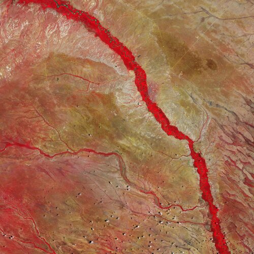
The Tana River, Kenya’s longest river, is featured in this false-colour image captured by the Copernicus Sentinel-2 mission.
Earth from Space: Tana River
18.6.2021 10:00 ESA Observing the Earth
The Tana River, Kenya’s longest river, is featured in this false-colour image captured by the Copernicus Sentinel-2 mission.
Přerušení dodávky elektřiny na KP Svitavy
18.6.2021 9:33 ČÚZK /Urady/Katastralni-urady/Katastralni-urady/Katastralni-urad-pro-Pardubicky-kraj/Katastralni-pracoviste/KP-Svitavy/O-uradu/Aktuality/Preruseni-dodavky-elektriny-na-KP-SvitavyPřerušení dodávky elektřiny na KP Svitavy
18.6.2021 9:33 ČÚZK - předpisy a opatření Katastrální úřad pro Pardubický kraj - Katastrální pracoviště Svitavy zveřejnil novou aktualitu: Dne 24.6.2021 dojde v čase 8.30 – 12.30 k přerušení dodávky elektřiny na KP Svitavy. Z toho důvodu nebude v provozu informační systém katastru nemovitostí.Epson Helps Print Service Providers Power Up Productivity with All-New Line of Production-Class SureColor P-Series Wide-Format Photo Printers
18.6.2021 9:00 GISCafe.com Webcasts-Webinars SureColor P8570D 44-Inch Powerhouse Printer, First in New Line, Delivering High-Volume Production-Level Print Speeds in Reimagined Space-Saving …Geoxphere launches Free Tier of its XMAP Cloud GIS service for UK Local Government
18.6.2021 9:00 GISCafe.com Webcasts-Webinars Basingstoke, UK, 14 June 2021 -- Geoxphere has launched a new subscription tier to its web mapping service for Local Government that makes the …Boston University Uses Bluesky Aerial Photomaps to Research Climate Change
18.6.2021 9:00 GISCafe.com Webcasts-Webinars Massachusetts, 15 June 2021 – Researchers at Boston University are using high resolution aerial photography to investigate how important …Young Professional Scholarship Opportunity Available from URISA
18.6.2021 9:00 GISCafe.com Webcasts-Webinars Des Plaines, IL (June 17, 2021) URISA is pleased to accept applications for the 2021 URISA Dr. Marilyn O'Hara Ruiz Young Professional …Bentley Systems Completes Acquisition of Seequent, Global Leader in 3D Modeling Software for the Geosciences
18.6.2021 1:58 GISCafe.com Webcasts-Webinars EXTON, Pa. — (BUSINESS WIRE) — June 17, 2021 —Bentley Systems, Incorporated (Nasdaq: BSY), the infrastructure engineering …
Hydrosat Raises $5M to Take on Climate Change from Space
18.6.2021 1:58 GISCafe.com Webcasts-Webinars Funding Led by Cultivation Capital to Power First Space Mission WASHINGTON — (BUSINESS WIRE) — June 17, 2021 —
Hydrosat, a …
Omezení provozu pobočky Svitavy 24. 6. 2021
18.6.2021 0:00 Státní pozemkový úřad Dovolujeme si vás informovat, že dne 24.6.2021 od 8. 00 hod. do 16.30 hod. bude omezen provoz na Pobočce Svitavy z důvodu přerušení dodávky elektrické energie. Provoz podatelny bude zajištěn.Za případné komplikace se omlouváme a děkujeme za pochopení.
Omezení provozu pobočky Svitavy
18.6.2021 0:00 Státní pozemkový úřad Dovolujeme si vás informovat, že dne 24.6.2021 od 8. 00 hod. do 16.30 hod. bude omezen provoz na Pobočce Svitavy z důvodu přerušení dodávky elektrické energie. Provoz podatelny bude zajištěn.Za případné komplikace se omlouváme a děkujeme za pochopení.
Fortem Technologies Selected to Join Federal Aviation Administration's Aviation Rulemaking Committee (ARC)
17.6.2021 20:02 GISCafe.com Webcasts-Webinars Pleasant Grove, UT, June 17, 2021 (GLOBE NEWSWIRE) -- Fortem Technologies, a leader in airspace security and defense for detecting and …New Chair for the EUSPA Administrative Board
17.6.2021 19:03 European GNSS Agency and Bruno Vermeire, Security Accreditation Board chair (right) with the newly elected EUSPA Administrative Board Chair, Vaclav Kobera.")
The Member states of the European Union Agency for the Space Programme elected today Václav Kobera to chair its Administrative Board.
During the 1st meeting of EUSPA’s Administrative Board, Mr Vaclav Kobera, Director of the Department of Intelligent Transport Systems, Space Activities and Research, Development and Innovation at the Ministry of Transport was elected as its new chair by the Member States and the European Commission representatives.
Mr Kobera is a Czech national with vast experience in space-related activities and more concretely satellite navigation. He has held several managerial positions in the public sector, namely the Czech Ministry of Transport.
“I am happy and honoured for the trust of the EU Member States and the European Commission gave me while electing me as Chair of the EUSPA Administrative Board. We need to face together the many challenges in front of us. I am ready to support the Member States and the Commission to prepare EUSPA to fulfil all its entrusted tasks and be a valuable partner for ESA, industry and other stakeholders”, stated Kobera.
Kobera thanked outgoing acting Chair Alberto Tuozzi, Head of the Telecommunications and Navigation of ASI (Italian Space Agency) for his leadership over the past few months.
“With transition of the GSA into EUSPA officially on May 12th 2021 our agency has a pivotal role to play in the delivery of the EU Space Programme.” says Executive Director Rodrigo da Costa. “I look forward to working closely with our new Chair as EUSPA has set off to an exciting EU Space journey!”
The EUSPA Administrative Board consists of representatives from each EU Member State, the European Commission, and the European parliament. The Board meets at least twice a year to take various decisions (budget, work programme, etc.) and ensure that the Agency performs its entrusted tasks according to the regulation.
Media note: This feature can be republished without charge provided the European Union Agency for the Space Programme (EUSPA) is acknowledged as the source at the top or the bottom of the story. You must request permission before you use any of the photographs on the site. If you republish, we would be grateful if you could link back to the EUSPA website (http://www.euspa.europa.eu).
Walmart Invests in DroneUp, the Nationwide On-Demand Drone Delivery Provider
17.6.2021 18:29 GISCafe.com Webcasts-Webinars BENTONVILLE, Ark — (BUSINESS WIRE) — June 17, 2021 —
CEO and President of Walmart’s U.S. business, John Furner, released …
AgEagle™ Aerial Systems Announces Jesse Stepler as President of Measure and New Hires for Key Management Roles
17.6.2021 18:29 GISCafe.com Webcasts-Webinars WICHITA, Kan., June 17, 2021 (GLOBE NEWSWIRE) -- AgEagle™ Aerial Systems Inc. (NYSE American: UAVS) (“AgEagle” or the …Cyclomedia Awarded RFP For Tennessee DOT
17.6.2021 18:29 GISCafe.com Webcasts-Webinars Continues Momentum as Leading Provider for Statewide Asset ManagementSAN RAFAEL, Calif., June 17, 2021 — (PRNewswire) — …
Teledyne to lead GeoAI discussion at Canadian Symposium on Remote Sensing
17.6.2021 18:04 GISCafe.com Webcasts-Webinars Vaughan, CANADA, June 17, 2021 -- Teledyne Optech and Teledyne CARIS, both Teledyne Technologies [NYSE:TDY] companies and global leaders in …eBook: Find the Right Geospatial Imagery for Your Project
17.6.2021 18:00 GISCafe.com Webcasts-WebinarsEsri’s ArcGIS Platform Chosen for Red Bull X-Alps Competition Live Tracking App by zooom Productions
17.6.2021 15:16 GISCafe.com Webcasts-Webinars Agency Integrates Esri Platform as a Service for Real-Time Event ExperienceREDLANDS, Calif — (BUSINESS WIRE) — June 17, 2021 …
U.S. Autonomous Drone Maker Skydio Selected by the FAA to Serve in the New Aviation Rulemaking Committee for BVLOS Flight
17.6.2021 15:16 GISCafe.com Webcasts-Webinars Jenn Player, Skydio’s new Director of Regulatory Affairs, was appointed as a working group industry leadREDWOOD CITY, Calif. — (BUSINESS …