


![]()

zprávy
zdroje zpráv:ÚCL SPOUŠTÍ ONLINE REGISTRACI PROVOZOVATELŮ DRONŮ OD 4.12.2020
2.12.2020 7:15 UAVAÚřad pro civilní letectví dnes spustil novou webovou stránku https://dron.caa.cz/ s dalšími informacemi o nových pravidlech provozu dronů od 31.12.2020 a na kterém bude spuštěna registrace provozovatelů a online testy již tento pátek 4.12.2020! Více informací lze nalézt zde: https://www.caa.cz/news/zakladni-informace-ke-zmenam-v-regulaci-dronu-od-31-12-2020/
The post ÚCL SPOUŠTÍ ONLINE REGISTRACI PROVOZOVATELŮ DRONŮ OD 4.12.2020 appeared first on UAV Aliance pro bezpilotní letecký průmysl.
HPE Reports Fiscal 2020 Fourth Quarter
2.12.2020 1:37 GISCafe.com Webcasts-Webinars Strong rebound in revenue; raising FY21 EPS outlookQ4 2020 Financial Highlights:
Revenue: returned to pre-pandemic levels of $7.2 billion, up 6% …
Cities and Regions of the EU’s UAM Initiative present the ‘Manifesto on the Multilevel Governance of the Urban Sky’
2.12.2020 1:30 GISCafe.com Webcasts-Webinars AMSTERDAM, 1 December 2020 - At the first day of the online conference ADW Hybrid, a first batch of fourteen European cities and regions, members of …USGIF High School Industry Geospatial-Intelligence Credentialing added to Missouri’s High School Industry Recognized Credential List
2.12.2020 1:27 GISCafe.com Webcasts-Webinars Missouri high school districts can choose, independently, to give high school credits to students who take and pass AYBAA and USGIF’s …ERIS and GeoSearch Unite, Raising the Standard of Environmental Property Due Diligence in North America
1.12.2020 22:42 GISCafe.com Webcasts-Webinars Combining Strengths in Environmental Risk Data, Historical Information, and Leading TechnologiesAUSTIN, Texas & TORONTO — (BUSINESS WIRE) …
Esri Joins GEOBIM 2020 Conference
1.12.2020 22:41 GISCafe.com Webcasts-Webinars Esri Experts to Demonstrate How Architects, Engineers, and Construction Professionals Improve BIM Processes with Location IntelligenceREDLANDS, …
National Geospatial-Intelligence Agency (NGA) selects Intermap Director Jack Hild for induction into the Geospatial Intelligence (GEOINT) Hall of Fame
1.12.2020 20:49 GISCafe.com Webcasts-Webinars DENVER, Dec. 1, 2020 — (PRNewswire) — Intermap Technologies Corporation ("Intermap" or the "Company"), a global leader in …Supply Side: CN Signs Contract with Duos, Bentley Launches Virtuosity
1.12.2020 18:38 Bentley SystemsPress Coverage
Railway Age, USA
Read the articleDigital Twins and Smart City Impact on Design, Build, and Manage
1.12.2020 18:35 Bentley SystemsPress Coverage
AECbytes, USA
Read the articleThe Digital Transformation Journey Continues at ARC India's Virtual Forum (Part 2)
1.12.2020 18:31 Bentley SystemsPress Coverage
ARC Advisory Group, USA
Read the articleMicrosoft CEO Satya Nadella — Featured Speaker at Bentley YII2020
1.12.2020 18:25 Bentley SystemsPress Coverage
Architosh, USA
Read the articleAccessing Information
1.12.2020 18:19 Bentley SystemsPress Coverage
Construction Today, UK
Read the articleBentley Systems Announces Finalists in the Year in Infrastructure 2020 Awards Program
1.12.2020 18:14 Bentley SystemsPress Coverage
GeoConnexion, UK
Read the articleA-68A on the move
1.12.2020 17:00 ESA Observing the Earth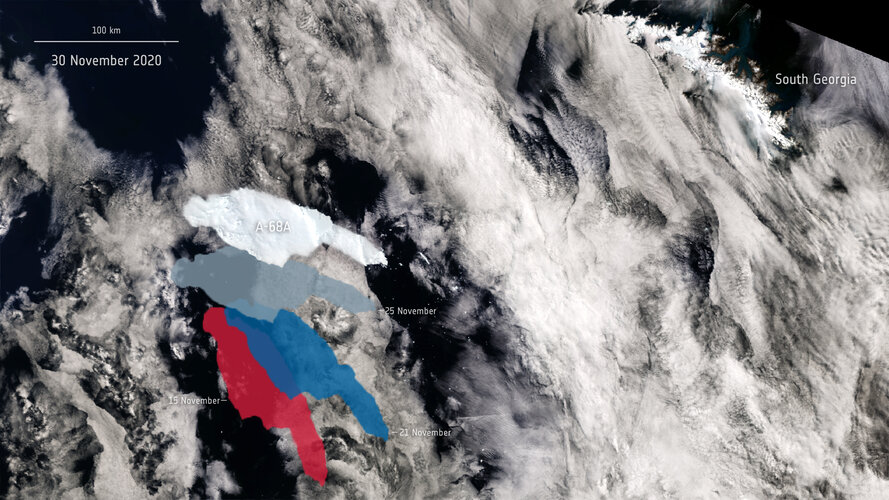 Image:
All eyes remain on the giant A-68A iceberg on its journey across the Southern Ocean. This image shows A-68A’s movements over the past 15 days using data from the Copernicus Sentinel-1 and Sentinel-3 missions.
Image:
All eyes remain on the giant A-68A iceberg on its journey across the Southern Ocean. This image shows A-68A’s movements over the past 15 days using data from the Copernicus Sentinel-1 and Sentinel-3 missions.
Geodesign as a “coordinator” for planning projects - Interview with Jesse Suders, Community and Economic Development Manager, Dawood Engineering
1.12.2020 16:09 GISCafe.com Webcasts-WebinarsBlackSky Names Uyen Dinh as Vice President for Government Relations and Strategy
1.12.2020 15:57 GISCafe.com Webcasts-Webinars HERNDON, Va. — (BUSINESS WIRE) — December 1, 2020 —BlackSky, a leading provider of global monitoring services and geospatial …
Utilis Inc. certified with Esri Release Ready Specialty
1.12.2020 15:57 GISCafe.com Webcasts-Webinars Utilis Inc. plans to follow-up by becoming certified to sell their solutions on the Esri MarketplaceSAN DIEGO, Dec. 1, 2020 — (PRNewswire) …
Gaining Momentum: Annual U.S. Home Prices Appreciated 7.3% in October, CoreLogic Reports
1.12.2020 15:57 GISCafe.com Webcasts-Webinars U.S. Home Price Index experienced the fastest annual acceleration since April 2014HPI Forecast predicts home price growth will slow through …
Velodyne Lidar Announces Autonomous Driving Collaboration with Ford Otosan
1.12.2020 15:57 GISCafe.com Webcasts-Webinars Companies Working Together on Autonomous Driving Development and Testing for Heavy Commercial VehiclesSAN JOSE, Calif. — (BUSINESS WIRE) …
20201201 - sběrný box
1.12.2020 10:59 ČÚZK - předpisy a opatření Katastrální úřad pro Ústecký kraj - Katastrální pracoviště Děčín zveřejnil novou aktualitu: Upozorňujeme na možnost učinit podání bezkontaktně do schránky umístěné ve vstupní hale budovy! Lze tak podat i návrh na vklad v zalepené obálce. Uveďte v podání Váš mail, budeme Vás informovat o přijetí, případně vyzveme k zaplacení poplatku převodem na účet. Schránka je přístupná v pondělí a středu od 8:00 do 17:00, v úterý a čtvrtek od 8:00 do 14:00 a v pátek od 8:00 do 12:00.20201201 - sběrný box
1.12.2020 10:59 ČÚZK /Urady/Katastralni-urady/Katastralni-urady/Katastralni-urad-pro-Ustecky-kraj/Katastralni-pracoviste/KP-Decin/O-uradu/Aktuality/20201030-zmena-urednich-hodin-od-2-11-2020-(1)Prosincové online BIM akce CAD Studia
1.12.2020 1:00 CAD Studio V prosincovém kalendáři online akcí CAD Studia nyní najdete sérii specializovaných online školení a webinářů zaměřených na různé profese z oblasti BIM projektování pozemních a inženýrských staveb. Díky těmto krátkým online akcím můžete snadno zvýšit ...Nová verze CS+ nadstavby CADstudio Fusion Tools
1.12.2020 1:00 CAD Studio Byla uvolněna nová verze bonus nadstavby Fusion Tools 1.0 (F-Tools), která dále rozšiřuje funkce populární CAD/CAM/CAE/EDA aplikace Autodesk Fusion 360 ve verzi pro Windows.
Tento bonus doplněk nainstalujete nebo zaktualizujete snadno pomocí ...
Byla uvolněna nová verze bonus nadstavby Fusion Tools 1.0 (F-Tools), která dále rozšiřuje funkce populární CAD/CAM/CAE/EDA aplikace Autodesk Fusion 360 ve verzi pro Windows.
Tento bonus doplněk nainstalujete nebo zaktualizujete snadno pomocí ...INDUS.AI launches new Autodesk BIM 360 integration to improve construction project productivity and safety
1.12.2020 0:51 GISCafe.com Webcasts-Webinars Construction teams can now easily monitor project performance, progress and safety in real-timeSAN FRANCISCO, Nov. 30, 2020 — (PRNewswire) …
Státní pozemkový úřad zahájil 14. ročník soutěže Žít krajinou
1.12.2020 0:00 Státní pozemkový úřad Praha, 1. prosince 2020 – Soutěž zaměřenou na komplexní pozemkové úpravy pořádá Státní pozemkový úřad (SPÚ) ve spolupráci s Českomoravskou komorou pro pozemkové úpravy (ČMKPÚ) již od roku 2006. Krajské pobočky SPÚ, projektanti, stavitelé nebo obce či vlastníci realizované stavby mohou své projekty přihlásit do 31. ledna 2021. Soutěž podporuje projekty, které svým charakterem splňují požadavky na celkové řešení krajiny nebo její části. Přihlásit lze takové projekty, které byly dokončeny nejpozději 31. prosince 2019.Pozvánka na přednášku
1.12.2020 0:00 Geografický ústav MUDovolujeme si Vás jménem Institutu Cervantes v Praze pozvat na přednášku věnovanou první cestě kolem světa, kterou uskutečnili mořeplavci Magalhães a Elcano a jejíž 500. výročí si tímto připomínáme. Přednáška se bude konat online, a to v úterý 1. prosince od 18:00 na následujícím odkazu: https://zoom.us/j/93219549496?pwd=enJkR1MzaU9JVUxZVk9aTjhpZklUUT09#success.
Se svými příspěvky vystoupí historikové Susana García Ramírez (vedoucí oddělení Výzkumu a sbírek španělského Námořního muzea a kurátorka výroční výstavy), profesor Josef Opatrný z Univerzity Karlovy a docent Jiří Chalupa z Ostravské univerzity.
Přednáška bude ve španělském jazyce se simultánním tlumočením do češtiny.
Státní pozemkový úřad zahájil 14. ročník soutěže Žít krajinou
1.12.2020 0:00 Státní pozemkový úřad Praha, 1. prosince 2020 – Soutěž zaměřenou na komplexní pozemkové úpravy pořádá Státní pozemkový úřad (SPÚ) ve spolupráci s Českomoravskou komorou pro pozemkové úpravy (ČMKPÚ) již od roku 2006. Krajské pobočky SPÚ, projektanti, stavitelé nebo obce či vlastníci realizované stavby mohou své projekty přihlásit do 31. ledna 2021. Soutěž podporuje projekty, které svým charakterem splňují požadavky na celkové řešení krajiny nebo její části. Přihlásit lze takové projekty, které byly dokončeny nejpozději 31. prosince 2019.Atkins establishes a detailed GIS using innovative technology
30.11.2020 20:25 Bentley SystemsPress Coverage
Construction Week Online, India
Read the articleVláda schválila navýšení rozpočtu ministerstva zemědělství, dostane o tři miliardy korun více. Část půjde na pozemkové úpravy
30.11.2020 20:25 ZeměměřičO tři miliardy korun navíc bude mít letos Ministerstvo zemědělství (MZe) na programy vodního hospodářství proti suchu a pozemkové úpravy. Navýšení rozpočtu dnes na jeho žádost schválila vláda. Na programy vodního hospodářství získalo MZe 1,7 miliardy korun, na pozemkové úpravy 1,3 miliardy korun. Peníze půjdou například na obnovu a výstavbu rybníků a malých vodních nádrží, závlahy, propojování vodárenských […]
The post Vláda schválila navýšení rozpočtu ministerstva zemědělství, dostane o tři miliardy korun více. Část půjde na pozemkové úpravy appeared first on Zeměměřič.
Vláda schválila navýšení rozpočtu ministerstva zemědělství, dostane o tři miliardy korun více. Část půjde na pozemkové úpravy
30.11.2020 20:25 ZeměměřičO tři miliardy korun navíc bude mít letos Ministerstvo zemědělství (MZe) na programy vodního hospodářství proti suchu a pozemkové úpravy. Navýšení rozpočtu dnes na jeho žádost schválila vláda. Na programy vodního hospodářství získalo MZe 1,7 miliardy korun, na pozemkové úpravy 1,3 miliardy korun. Peníze půjdou například na obnovu a výstavbu rybníků a malých vodních nádrží, závlahy, propojování vodárenských […]
The post Vláda schválila navýšení rozpočtu ministerstva zemědělství, dostane o tři miliardy korun více. Část půjde na pozemkové úpravy appeared first on Zeměměřič.
Simulating Spaces for Social Distancing
30.11.2020 20:12 Bentley SystemsPress Coverage
Informed Infrastructure, USA
Read the articleDigital twin technology – a future UK export success?
30.11.2020 20:09 Bentley SystemsPress Coverage
Infrastructure Intelligence, UK
Read the articleTwo Australian finalists in Year in Infrastructure 2020 awards
30.11.2020 20:05 Bentley SystemsPress Coverage
Spatial Source, ANZ
Read the articleBentley’s Year in Infrastructure (YII) Goes Live for the First Time
30.11.2020 20:02 Bentley SystemsPress Coverage
Engineering.com, USA
Read the articleBentley Systems Announces Finalists in the Year in Infrastructure 2020 Awards Program
30.11.2020 19:55 Bentley SystemsPress Coverage
Manufacturing and Engineering Magazine, UK
Read the article20201130 - Nová verze Aplikace pro kontroly dat RÚIAN
30.11.2020 19:00 ČÚZK /Uvod/Produkty-a-sluzby/RUIAN/RUIAN-novinky/2020/20201130-Nova-verze-Aplikace-pro-kontroly-dat-RU20201130 - Nová verze Aplikace pro kontroly dat RÚIAN
30.11.2020 19:00 ČÚZK - předpisy a opatření Dne 30. 11. 2020 byla vystavena nová verze Aplikace pro kontroly dat RÚIAN, rozšířená o statistiky za kraj. V případě problémů se zobrazením stránky použijte Ctrl+F5 pro aktualizaci stránky.The Cohesive Companies announce the acquisition of UK-based Maximo solutions provider SRO Solutions
30.11.2020 17:51 Bentley SystemsWill strengthen Cohesive Companies in the global maritime and resources industries
EXTON, Pa. – November 30, 2020 - The Cohesive Companies, a wholly-owned but independently operated digital integrator business unit of Bentley Systems, Incorporated (Nasdaq: BSY, the infrastructure engineering software company), today announced its acquisition of SRO Solutions (“SRO”) to extend its capabilities for marine and industrial infrastructure. Established in 2004, SRO introduced IBM’s Maximo to the maritime environment, managing projects across all seven continents for an extensive list of blue-chip owner-operators of assets on- and off-shore. SRO, a Gold Accredited IBM Business Partner, provides unique Maximo replication and zero downtime upgrade solutions.
Headquartered in Manchester, UK, SRO approaches each project with a disciplined agile methodology, underpinned by a rich engineering heritage and strong technical competence. SRO’s engineers, consultants, and project managers wield extensive experience in delivering Maximo solutions across a wide range of sectors, led by maritime and oil and gas. Products include SDU (SRO Data Utility), which eliminates downtime and provides upgrade and migration processes that permit businesses to keep running while software (for example, large Maximo instances) are being updated; and SDR (SRO Data Replication), which assures data synchronization across remote geographies and intermittent connections.
“We are excited to welcome Tony Lackey and the SRO team, with their technical expertise and hands-on knowledge of resources industries,” said Noah Eckhouse, CEO, The Cohesive Companies. “Our goal, as an autonomous digital integrator consultancy, is to support global owner-operators and their assets literally everywhere in going digital. Incorporating SRO’s comprehensive product and service offerings, and their uniquely deep experience in maintaining safety and regulatory compliance in challenging and low/no-bandwidth environments, will help our emerging digital twin offerings to reach the full extent of maritime and industrial assets.”
SRO Managing Director Tony Lackey said, “We are excited for SRO to join The Cohesive Companies, as we have worked for years with Cohesive in America and recently have also partnered on opportunities here in the UK. I would like to thank all the team at SRO for their work in making this milestone possible.
“It is timely that we are adding SRO’s Maximo solutions, and maritime and industrial expertise, to what The Cohesive Companies can now offer globally. Advancements in going digital are driving improvements in maritime, offshore and energy asset management – leading towards the breakthrough advantages of infrastructure digital twins. We know that together, we can deliver even more operational value for owner-operator organizations!”

Caption: SRO Solutions replaced the British Antarctic Survey’s (BAS) current asset management system with IBM Maximo for their entire existing polar fleet of aircraft and ships, as well as implementing Maximo on the new Antarctic flagship RRS Sir David Attenborough.
About The Cohesive Companies
The Cohesive Companies form a wholly-owned but independently operated business unit of Bentley Systems (Nasdaq: BSY, the infrastructure engineering software company www.bentley.com).
The Cohesive Companies provide advisory, systems integration, and technology strategies and services to help infrastructure owner-operators advance their BIM, enterprise asset management (EAM), and asset lifecycle information (ALIM) environments through asset performance digital twins. The Cohesive Companies comprise PCSG (leading provider of digital advisory services for built-environment owners), Cohesive SRO (leading UK-based provider of solutions for IBM’s Maximo EAM software), Cohesive Solutions (leading North American reseller of Maximo, helping owner-operators to continuously improve their asset management) and Cohesive Asset Performance (leading global integrator for Asset Performance Modeling). www.cohesivecompanies.com
© 2020 Bentley Systems, Incorporated. Bentley, the Bentley logo, Cohesive Solutions, Cohesive Asset Performance, PCSG, SRO Solutions, and The Cohesive Companies are either registered or unregistered trademarks or service marks of Bentley Systems, Incorporated or one of its direct or indirect wholly owned subsidiaries. All other brands and product names are trademarks of their respective owners.
The Cohesive Companies announce the acquisition of UK-based Maximo solutions provider SRO Solutions
30.11.2020 17:51 Bentley SystemsWill strengthen Cohesive Companies in the global maritime and resources industries
EXTON, Pa. – November 30, 2020 - The Cohesive Companies, a wholly-owned but independently operated digital integrator business unit of Bentley Systems, Incorporated (Nasdaq: BSY, the infrastructure engineering software company), today announced its acquisition of SRO Solutions (“SRO”) to extend its capabilities for marine and industrial infrastructure. Established in 2004, SRO introduced IBM’s Maximo to the maritime environment, managing projects across all seven continents for an extensive list of blue-chip owner-operators of assets on- and off-shore. SRO, a Gold Accredited IBM Business Partner, provides unique Maximo replication and zero downtime upgrade solutions.
Headquartered in Manchester, UK, SRO approaches each project with a disciplined agile methodology, underpinned by a rich engineering heritage and strong technical competence. SRO’s engineers, consultants, and project managers wield extensive experience in delivering Maximo solutions across a wide range of sectors, led by maritime and oil and gas. Products include SDU (SRO Data Utility), which eliminates downtime and provides upgrade and migration processes that permit businesses to keep running while software (for example, large Maximo instances) are being updated; and SDR (SRO Data Replication), which assures data synchronization across remote geographies and intermittent connections.
“We are excited to welcome Tony Lackey and the SRO team, with their technical expertise and hands-on knowledge of resources industries,” said Noah Eckhouse, CEO, The Cohesive Companies. “Our goal, as an autonomous digital integrator consultancy, is to support global owner-operators and their assets literally everywhere in going digital. Incorporating SRO’s comprehensive product and service offerings, and their uniquely deep experience in maintaining safety and regulatory compliance in challenging and low/no-bandwidth environments, will help our emerging digital twin offerings to reach the full extent of maritime and industrial assets.”
SRO Managing Director Tony Lackey said, “We are excited for SRO to join The Cohesive Companies, as we have worked for years with Cohesive in America and recently have also partnered on opportunities here in the UK. I would like to thank all the team at SRO for their work in making this milestone possible.
“It is timely that we are adding SRO’s Maximo solutions, and maritime and industrial expertise, to what The Cohesive Companies can now offer globally. Advancements in going digital are driving improvements in maritime, offshore and energy asset management – leading towards the breakthrough advantages of infrastructure digital twins. We know that together, we can deliver even more operational value for owner-operator organizations!”
Caption: SRO Solutions replaced the British Antarctic Survey’s (BAS) current asset management system with IBM Maximo for their entire existing polar fleet of aircraft and ships, as well as implementing Maximo on the new Antarctic flagship RRS Sir David Attenborough.
About The Cohesive Companies
The Cohesive Companies form a wholly-owned but independently operated business unit of Bentley Systems (Nasdaq: BSY, the infrastructure engineering software company www.bentley.com).
The Cohesive Companies provide advisory, systems integration, and technology strategies and services to help infrastructure owner-operators advance their BIM, enterprise asset management (EAM), and asset lifecycle information (ALIM) environments through asset performance digital twins. The Cohesive Companies comprise PCSG (leading provider of digital advisory services for built-environment owners), Cohesive SRO (leading UK-based provider of solutions for IBM’s Maximo EAM software), Cohesive Solutions (leading North American reseller of Maximo, helping owner-operators to continuously improve their asset management) and Cohesive Asset Performance (leading global integrator for Asset Performance Modeling). www.cohesivecompanies.com
© 2020 Bentley Systems, Incorporated. Bentley, the Bentley logo, Cohesive Solutions, Cohesive Asset Performance, PCSG, SRO Solutions, and The Cohesive Companies are either registered or unregistered trademarks or service marks of Bentley Systems, Incorporated or one of its direct or indirect wholly owned subsidiaries. All other brands and product names are trademarks of their respective owners.
The Cohesive Companies announce the acquisition of UK-based Maximo solutions provider SRO Solutions
30.11.2020 17:51 Bentley SystemsWill strengthen Cohesive Companies in the global maritime and resources industries
EXTON, Pa. – November 30, 2020 - The Cohesive Companies, a wholly-owned but independently operated digital integrator business unit of Bentley Systems, Incorporated (Nasdaq: BSY, the infrastructure engineering software company), today announced its acquisition of SRO Solutions (“SRO”) to extend its capabilities for marine and industrial infrastructure. Established in 2004, SRO introduced IBM’s Maximo to the maritime environment, managing projects across all seven continents for an extensive list of blue-chip owner-operators of assets on- and off-shore. SRO, a Gold Accredited IBM Business Partner, provides unique Maximo replication and zero downtime upgrade solutions.
Headquartered in Manchester, UK, SRO approaches each project with a disciplined agile methodology, underpinned by a rich engineering heritage and strong technical competence. SRO’s engineers, consultants, and project managers wield extensive experience in delivering Maximo solutions across a wide range of sectors, led by maritime and oil and gas. Products include SDU (SRO Data Utility), which eliminates downtime and provides upgrade and migration processes that permit businesses to keep running while software (for example, large Maximo instances) are being updated; and SDR (SRO Data Replication), which assures data synchronization across remote geographies and intermittent connections.
“We are excited to welcome Tony Lackey and the SRO team, with their technical expertise and hands-on knowledge of resources industries,” said Noah Eckhouse, CEO, The Cohesive Companies. “Our goal, as an autonomous digital integrator consultancy, is to support global owner-operators and their assets literally everywhere in going digital. Incorporating SRO’s comprehensive product and service offerings, and their uniquely deep experience in maintaining safety and regulatory compliance in challenging and low/no-bandwidth environments, will help our emerging digital twin offerings to reach the full extent of maritime and industrial assets.”
SRO Managing Director Tony Lackey said, “We are excited for SRO to join The Cohesive Companies, as we have worked for years with Cohesive in America and recently have also partnered on opportunities here in the UK. I would like to thank all the team at SRO for their work in making this milestone possible.
“It is timely that we are adding SRO’s Maximo solutions, and maritime and industrial expertise, to what The Cohesive Companies can now offer globally. Advancements in going digital are driving improvements in maritime, offshore and energy asset management – leading towards the breakthrough advantages of infrastructure digital twins. We know that together, we can deliver even more operational value for owner-operator organizations!”
Caption: SRO Solutions replaced the British Antarctic Survey’s (BAS) current asset management system with IBM Maximo for their entire existing polar fleet of aircraft and ships, as well as implementing Maximo on the new Antarctic flagship RRS Sir David Attenborough.
About The Cohesive Companies
The Cohesive Companies form a wholly-owned but independently operated business unit of Bentley Systems (Nasdaq: BSY, the infrastructure engineering software company www.bentley.com).
The Cohesive Companies provide advisory, systems integration, and technology strategies and services to help infrastructure owner-operators advance their BIM, enterprise asset management (EAM), and asset lifecycle information (ALIM) environments through asset performance digital twins. The Cohesive Companies comprise PCSG (leading provider of digital advisory services for built-environment owners), Cohesive SRO (leading UK-based provider of solutions for IBM’s Maximo EAM software), Cohesive Solutions (leading North American reseller of Maximo, helping owner-operators to continuously improve their asset management) and Cohesive Asset Performance (leading global integrator for Asset Performance Modeling). www.cohesivecompanies.com
© 2020 Bentley Systems, Incorporated. Bentley, the Bentley logo, Cohesive Solutions, Cohesive Asset Performance, PCSG, SRO Solutions, and The Cohesive Companies are either registered or unregistered trademarks or service marks of Bentley Systems, Incorporated or one of its direct or indirect wholly owned subsidiaries. All other brands and product names are trademarks of their respective owners.
V prosinci přechází ArcGIS Online na HTTPS
30.11.2020 15:41 blog ARCDATA Z důvodu zlepšení zabezpečení celého prostředí ArcGIS Online plánuje společnost Esri pro práci v ArcGIS Online povolit výhradně protokol HTTPS. Tato změna je plánovaná na 8. prosince 2020, respektive na prosincovou aktualizaci ArcGIS Online.20201130 Odborný referent oddělení aktualizace PI KN I.
30.11.2020 14:21 ČÚZK - předpisy a opatření Katastrální úřad pro Středočeský kraj - Katastrální pracoviště Praha-západ Vyhlášení výběrového řízení: Odborný referent oddělení aktualizace PI KN I. V části "Úřední deska", v sekci "Oznámení a jiná úřední sdělení" bylo vystaveno "Oznámení o vyhlášení výběrového řízení na obsazení služebního místa Odborný referent oddělení aktualizace PI KN I. "20201130 Odborný referent oddělení aktualizace PI KN I.
30.11.2020 14:21 ČÚZK /Urady/Katastralni-urady/Katastralni-urady/Katastralni-urad-pro-Stredocesky-kraj/Katastralni-pracoviste/KP-Praha-zapad/O-uradu/Aktuality/20190828-Odborny-rada-oddeleni-pravnich-vztahu-(5)Odborný referent oddělení aktualizace PI KN I.
30.11.2020 14:18 ČÚZK - volná místa Katastrální úřad pro Středočeský kraj - Katastrální pracoviště Praha-západ vypisuje výběrové řízení na místo Odborný referent oddělení aktualizace PI KN I.Odborný referent oddělení aktualizace PI KN I.
30.11.2020 14:18 ČÚZK /Urady/Katastralni-urady/Katastralni-urady/Katastralni-urad-pro-Stredocesky-kraj/Uredni-deska/Oznameni-a-jina-uredni-sdeleni/Volna-mista/Odborny-referent-oddeleni-aktualizace-PI-KN-I-(1)Odborný referent oddělení aktualizace PI KN I.
30.11.2020 14:18 ČÚZK - předpisy a opatření Katastrální úřad pro Středočeský kraj - Katastrální pracoviště Praha-západvypisuje výběrové řízení na místo Odborný referent oddělení aktualizace PI KN I.
Odborný referent oddělení aktualizace PI KN I.
Nabídka témat dizertačních [Katedra aplikované geoinformatiky a kartografie, byTopic]
30.11.2020 12:55 Katedra aplikované geoinformatiky a kartografie Přf UK Nabídka témat dizertačních prací pro doktorský studijní program Geoinformatika, kartografie a dálkový průzkum ZeměNabídka témat dizertačních prací [Katedra aplikované geoinformatiky a kartografie, byTopic]
30.11.2020 12:55 Katedra aplikované geoinformatiky a kartografie Přf UK Nabídka témat dizertačních prací pro doktorský studijní program Geoinformatika, kartografie a dálkový průzkum ZeměNabídka na koupi osobního automobilu Škoda Fabia
30.11.2020 12:53 ČÚZK - předpisy a opatřeníKatastrální úřad pro Královéhradecký kraj nabízí nepotřebný majetek k odkupu. Jedná se o
Nabídka na koupi osobního automobilu Škoda Fabia
Nabídka na koupi osobního automobilu Škoda Fabia
30.11.2020 12:53 ČÚZK /Urady/Katastralni-urady/Katastralni-urady/Katastralni-urad-pro-Kralovehradecky-kraj/Nabidky-majetku/Nabidka-na-koupi-osobniho-automobilu-Skoda-Fab-(3)Nabídka na koupi osobního automobilu Škoda Fabia
30.11.2020 12:53 ČÚZK /Urady/Katastralni-urady/Katastralni-urady/Katastralni-urad-pro-Kralovehradecky-kraj/Nabidky-majetku/Nabidka-na-koupi-osobniho-automobilu-Skoda-Fab-(2)Nabídka na koupi osobního automobilu Škoda Fabia
30.11.2020 12:53 ČÚZK - předpisy a opatřeníKatastrální úřad pro Královéhradecký kraj nabízí nepotřebný majetek k odkupu. Jedná se o
Nabídka na koupi osobního automobilu Škoda Fabia
Nabídka na koupi osobního automobilu Škoda Fabia
30.11.2020 12:52 ČÚZK /Urady/Katastralni-urady/Katastralni-urady/Katastralni-urad-pro-Kralovehradecky-kraj/Nabidky-majetku/Nabidka-na-koupi-osobniho-automobilu-Skoda-Fab-(1)Nabídka na koupi osobního automobilu Škoda Fabia
30.11.2020 12:52 ČÚZK - předpisy a opatřeníKatastrální úřad pro Královéhradecký kraj nabízí nepotřebný majetek k odkupu. Jedná se o
Nabídka na koupi osobního automobilu Škoda Fabia
Máte otázky ke studiu geoinformatiky?
30.11.2020 9:38 Katedra geoinformatiky UP OlomoucBlíží se nám Den otevřených dveří na Univerzita Palackého, letos v online podobě ℹ️ Protože se nás nemůžete fyzicky zeptat na to, co vás zajímá, připravili jsme pro vás dotazník https://forms.gle/yEsv7wiT8jRBzW5ZA , kde svou otázku jednoduše položíte 😊 My je všechny projdeme a v pátek zodpovíme ‼️ nebojte se, ptejte se 🙃
The post Máte otázky ke studiu geoinformatiky? appeared first on Katedra geoinformatiky.
ArcGIS Field Maps – do terénu v novém kabátě (workshop)
30.11.2020 8:08 GISportal.cz
V rámci letošní virtuální Konference GIS Esri v ČR proběhne online také několik workshopů. Poslední se bude konat v úterý 1. prosince v čase 10.00 – 11.00. Workshopem Vás provede Vladimír holubec ze společnosti ARCDATA PRAHA, s.r.o. Abstrakt workshopu: ArcGIS Field Maps je představitelem nové generace mobilních aplikací, které se snaží o maximální optimalizaci pracovních […]
The post ArcGIS Field Maps – do terénu v novém kabátě (workshop) appeared first on GISportal.cz.
Jak se mění BIM cloud společnosti Autodesk
30.11.2020 1:00 CAD Studio Pro projekční a stavební firmy se realizace projektů vinou COVIDu letos zkomplikovala. Řada firem významně urychlila tempo digitální transformace, výrazně přepracovala svůj přístup ke správě dat a ke spolupráci na projektech napříč týmy, projekty a ...Pobočka Břeclav ukončila realizaci plánu společných zařízení v k.ú. Klentnice
30.11.2020 0:00 Státní pozemkový úřad Pobočka Břeclav Krajského pozemkového úřadu pro Jihomoravský kraj realizovala po ukončených komplexních pozemkových úpravách na základě žádosti Obce Klentnice část prvků plánu společných zařízení, konkrétně zpevněnou polní cestu a odvodňovací příkop včetně výsadeb zeleně.Grand Finalists of the Farming by Satellite Prize 2020 Announced
27.11.2020 17:13 European GNSS Agency
Eight teams have been selected for the Grand Finale of the 5th Farming by Satellite Prize, which aims to promote the use of EGNSS and Earth Observation in sustainable agriculture in Europe and Africa.
This year, the competition has challenged teams from across Europe and Africa to use Satellite Technologies to improve Agriculture and reduce Environmental Impact, providing an opportunity for new EU space empowered ideas.
The winners of the Farming by Satellite Prize 2020, featuring the Special Africa Prize devoted to young African innovators, will be announced live at the online awards ceremony on 30 November 2020, starting at 18:00 CET. The teams will pitch their solutions to the audience, sharing their visions for sustainable agriculture. They will be joined by keynote speakers from the prize partners the European GNSS Agency, European Environment Agency and CLAAS, who will share insights into the use of European satellite technologies to improve agriculture, from both a policy and industry perspective.
For the full agenda and to register for the event, head to the Farming by Satellite Prize 2020 website here.
Watch this: European Satellites for Agriculture
Space for Agriculture: Meet the top 8 solutions
With more than 80 submissions from across Europe and Africa, received, 18 pre-selected teams participated in the Deep Dive Phase, presenting their innovations in pitch deck format. Eight grand finalists have been selected and are now competing for the first three places and the Special Africa Prize in a prize pool totalling €10,000:
- AI4Ocean Farming - Using satellite data for ocean farming
This solution studies the feasibility of establishing a space-connected ocean farming system. AI4OceanFarming identifies ocean farming threats to mitigate losses and increase the success rate and performance of this farm sector. This analysis is done by merging satellite data from Copernicus together with GNSS, Mercator Ocean, ECMWF, in-situ data from IoT devices deployed on the field, and their own specialised databases. The team hopes to optimise the performance of ocean farming, increasing food security and minimising the overexploitation of ocean resources.
- Genuine - Optimising tractor navigation route
Genuine is a unique web application to support farmers with identifying the crop borders, crop stress, and to guide tractor paths for optimal fertilization and irrigation. The solution combines Copernicus Sentinel-2 data and Galileo signals to generate prescription maps and to improve farmers’ activities in the field. The team aims to provide an integrated Copernicus and EGNSS solution that accelerates the transition to sustainable agriculture.
- Graniot - Satellite crop monitoring
One third of the water used in Europe goes to the agricultural sector. In Spain, that number rises to almost 80% and a part of it is wasted and/or contaminated by inefficient fertilising practices. Graniot offers a web application for agronomists and farmers to conduct weekly crop monitoring by using European satellite technologies to focus on vigour, chlorophyll, and water stress. With a background in telecommunications engineering, the co-founders are on a mission to bring a more sustainable agriculture to Southern Europe.
- RVRI - Irrigating the future
Water scarcity and CO2 emissions linked to pumping water are contributing to climate change. RVRI is a system that is able to detect the level of humidity of the soil and crop by analysing in real time the difference between the direct GNSS signal and the GNSS signal reflected on the soil. Copernicus Sentinel-2 imagery is used to show crop information in the mobile app. With this information the system can vary the irrigation rate and communicate with the cloud where the application data is stored. The team wants to create intelligent systems that do not overload farmers with data, but provide actionable insights.
- Harvesting Prizes - Farming correctly, we all win
Harvesting Prizes is a tool that integrates all Variable Rate Application (VRA) files for every land parcel in a farm. GNSS positioning data is used to localise the user and link all VRA maps. It is then able to translate the input rates into real monetary outcomes, like €/ha and kg CO2/ha. The solution integrates Copernicus Sentinel-2 images, Galileo Open Service Message Authentication Feature (OS-NMA), and cloud services to provide a robust service that is easy to use. Additionally, mobile networks will be used to transfer information to and from the cloud. The young innovators believe that sustainable agriculture practices should be rewarded directly to the farmer.
- BAOBAB - Bridging agriculture and satellite observations for the African farming business
The Baobab solution combines weather models and Earth observation data to support crop management by farmers. It exploits modern satellite technology to directly deliver timely and accurate weather forecasts to farmers. The data results are integrated into numerical weather prediction (NWP) models and delivered to the farmers for timely and accurate weather forecasts. This allows farmers to take early action and reduce potential damages. The team has the vision to significantly improve farming activities in Uganda.
- GeoM&E
GeoM&E offers farmers the opportunity to assess differences in agriculture fields over time and location, and enables users to assess vegetation phenology such as planting and harvesting. It specifically looks at the assessment of coffee farms in central Kenya, indicating the changes over time and areas where farmers could increase yield. The GeoM&E would provide African farmers with access to the geoinformation in just one click.
- HerdsAssist - The herder’s guide and foretell to pasture
HerdsAssist is a new way of grazing management for farmers to lessen the land competition in Africa. Using a mobile application that draws data such as land-use and land-cover maps from Copernicus, farmers can be better informed about the location of their kettle and where other farmlands are. For example, farmers can use a virtual fencing band that uses Galileo satellite positioning to determine the location of animals. The team behind HerdsAssist hopes to create the digital grazing management tool for farmers around the world.
Read this: From #EUSpace to farm to fork
About the Farming by Satellite Prize
The Farming by Satellite Prize rewards young innovators exploring the use of data and signals from the European space programmes Galileo, EGNOS, and Copernicus to improve agriculture and reduce environmental impact. A joint initiative of the GSA and the EEA, the prize invites applicants to submit their ideas for a more sustainable, productive, and efficient agriculture industry in Europe. Don’t forget to register for the award ceremony here.
Media note: This feature can be republished without charge provided the European GNSS Agency (GSA) is acknowledged as the source at the top or the bottom of the story. You must request permission before you use any of the photographs on the site. If you republish, we would be grateful if you could link back to the GSA website (http://www.gsa.europa.eu).
Grand Finalists of the Farming by Satellite Prize 2020 Announced
27.11.2020 17:13 European GNSS AgencyEight teams have been selected for the Grand Finale of the 5th Farming by Satellite Prize, which aims to promote the use of EGNSS and Earth Observation in sustainable agriculture in Europe and Africa.
This year, the competition has challenged teams from across Europe and Africa to use Satellite Technologies to improve Agriculture and reduce Environmental Impact, providing an opportunity for new EU space empowered ideas.
The winners of the Farming by Satellite Prize 2020, featuring the Special Africa Prize devoted to young African innovators, will be announced live at the online awards ceremony on 30 November 2020, starting at 18:00 CET. The teams will pitch their solutions to the audience, sharing their visions for sustainable agriculture. They will be joined by keynote speakers from the prize partners the European GNSS Agency, European Environment Agency and CLAAS, who will share insights into the use of European satellite technologies to improve agriculture, from both a policy and industry perspective.
For the full agenda and to register for the event, head to the Farming by Satellite Prize 2020 website here.
Watch this: European Satellites for Agriculture
Space for Agriculture: Meet the top 8 solutions
With more than 80 submissions from across Europe and Africa received, 18 pre-selected teams participated in the Deep Dive Phase, presenting their innovations in pitch deck format. Eight grand finalists have been selected and are now competing for the first three places and the Special Africa Prize in a prize pool totalling €10,000:
- AI4Ocean Farming - Using satellite data for ocean farming
This solution studies the feasibility of establishing a space-connected ocean farming system. AI4OceanFarming identifies ocean farming threats to mitigate losses and increase the success rate and performance of this farm sector. This analysis is done by merging satellite data from Copernicus together with GNSS, Mercator Ocean, ECMWF, in-situ data from IoT devices deployed on the field, and their own specialised databases. The team hopes to optimise the performance of ocean farming, increasing food security and minimising the overexploitation of ocean resources.
- Genuine - Optimising tractor navigation route
Genuine is a unique web application to support farmers with identifying the crop borders, crop stress, and to guide tractor paths for optimal fertilization and irrigation. The solution combines Copernicus Sentinel-2 data and Galileo signals to generate prescription maps and to improve farmers’ activities in the field. The team aims to provide an integrated Copernicus and EGNSS solution that accelerates the transition to sustainable agriculture.
- Graniot - Satellite crop monitoring
One third of the water used in Europe goes to the agricultural sector. In Spain, that number rises to almost 80% and a part of it is wasted and/or contaminated by inefficient fertilising practices. Graniot offers a web application for agronomists and farmers to conduct weekly crop monitoring by using European satellite technologies to focus on vigour, chlorophyll, and water stress. With a background in telecommunications engineering, the co-founders are on a mission to bring a more sustainable agriculture to Southern Europe.
- RVRI - Irrigating the future
Water scarcity and CO2 emissions linked to pumping water are contributing to climate change. RVRI is a system that is able to detect the level of humidity of the soil and crop by analysing in real time the difference between the direct GNSS signal and the GNSS signal reflected on the soil. Copernicus Sentinel-2 imagery is used to show crop information in the mobile app. With this information the system can vary the irrigation rate and communicate with the cloud where the application data is stored. The team wants to create intelligent systems that do not overload farmers with data, but provide actionable insights.
- Harvesting Prizes - Farming correctly, we all win
Harvesting Prizes is a tool that integrates all Variable Rate Application (VRA) files for every land parcel in a farm. GNSS positioning data is used to localise the user and link all VRA maps. It is then able to translate the input rates into real monetary outcomes, like €/ha and kg CO2/ha. The solution integrates Copernicus Sentinel-2 images, Galileo Open Service Message Authentication Feature (OS-NMA), and cloud services to provide a robust service that is easy to use. Additionally, mobile networks will be used to transfer information to and from the cloud. The young innovators believe that sustainable agriculture practices should be rewarded directly to the farmer.
- BAOBAB - Bridging agriculture and satellite observations for the African farming business
The Baobab solution combines weather models and Earth observation data to support crop management by farmers. It exploits modern satellite technology to directly deliver timely and accurate weather forecasts to farmers. The data results are integrated into numerical weather prediction (NWP) models and delivered to the farmers for timely and accurate weather forecasts. This allows farmers to take early action and reduce potential damages. The team has the vision to significantly improve farming activities in Uganda.
- GeoM&E
GeoM&E offers farmers the opportunity to assess differences in agriculture fields over time and location, and enables users to assess vegetation phenology such as planting and harvesting. It specifically looks at the assessment of coffee farms in central Kenya, indicating the changes over time and areas where farmers could increase yield. The GeoM&E would provide African farmers with access to the geoinformation in just one click.
- HerdsAssist - The herder’s guide and foretell to pasture
HerdsAssist is a new way of grazing management for farmers to lessen the land competition in Africa. Using a mobile application that draws data such as land-use and land-cover maps from Copernicus, farmers can be better informed about the location of their kettle and where other farmlands are. For example, farmers can use a virtual fencing band that uses Galileo satellite positioning to determine the location of animals. The team behind HerdsAssist hopes to create the digital grazing management tool for farmers around the world.
Read this: From #EUSpace to farm to fork
About the Farming by Satellite Prize
The Farming by Satellite Prize rewards young innovators exploring the use of data and signals from the European space programmes Galileo, EGNOS, and Copernicus to improve agriculture and reduce environmental impact. A joint initiative of the GSA and the EEA, the prize invites applicants to submit their ideas for a more sustainable, productive, and efficient agriculture industry in Europe. Don’t forget to register for the award ceremony here.
Media note: This feature can be republished without charge provided the European GNSS Agency (GSA) is acknowledged as the source at the top or the bottom of the story. You must request permission before you use any of the photographs on the site. If you republish, we would be grateful if you could link back to the GSA website (http://www.gsa.europa.eu).
Noc vědců: Návrat do minulosti s pomocí geoinformatiků [Katedra aplikované geoinformatiky a kartografie, byTopic]
27.11.2020 13:00 Katedra aplikované geoinformatiky a kartografie Přf UK V letošním roce se zapojila výzkumná skupina EO4Landscape (pod vedením doc. Přemysla Štycha) do programu Noci vědců se svým příspěvkem "Návrat do minulosti s pomocí geoinformatiků". V rámci příspěvku jsou představeny soudobé možnosti geoinformačních systémů. Příspěvek se zaměřuje na 3D modelace zaniklých území (středověkého Ostrovského kláštera nebo Lipnem zatopené Dolní Vltavice), dále na možnosti dálkového průzkumu Země (DPZ) pro pozorování globálních problémů (deforestace, desertifikace, úbytků ledovců nebo masivního rozrůstání měst), případně na využití DPZ pro pozorování potenciálních míst k reintrodukci koně Převalského do volné přírody v Mongolsku nebo i na soudobé problémy lesních disturbancí ve střední Evropě.Let ‘s Hrdlička – Podcast s Leou Leinweberovou
27.11.2020 11:57 Hrdlička Přinášíme Vám Podcast s Leou Leinweberovou, vedoucí oddělení G3D.odborný / vrchní referent v oddělení dokumentace katastru nemovitostí Katastrálního pracoviště Pardu
27.11.2020 11:01 ČÚZK /Urady/Katastralni-urady/Katastralni-urady/Katastralni-urad-pro-Pardubicky-kraj/Uredni-deska/Oznameni-a-jina-uredni-sdeleni/Volna-mista/odborny-vrchni-referent-v-oddeleni-dokumentace-kodborný / vrchní referent v oddělení dokumentace katastru nemovitostí Katastrálního pracoviště Pardu
27.11.2020 11:01 ČÚZK - předpisy a opatření Katastrální úřad pro Pardubický kraj - Katastrální pracoviště Pardubicevypisuje výběrové řízení na místo
odborný / vrchní referent v oddělení dokumentace katastru nemovitostí Katastrálního pracoviště Pardubice
odborný / vrchní referent v oddělení dokumentace katastru nemovitostí Katastrálního pracoviště Pardu
27.11.2020 11:01 ČÚZK - volná místa Katastrální úřad pro Pardubický kraj - Katastrální pracoviště Pardubice vypisuje výběrové řízení na místo odborný / vrchní referent v oddělení dokumentace katastru nemovitostí Katastrálního pracoviště Pardu20201127 - Ukázky změnových souborů VFR
27.11.2020 10:27 ČÚZK - předpisy a opatření Na stránce Dopady zákona č. 51/2020 Sb., o územně správním členění státu do RÚIAN byly doplněny ukázky změnových souborů VFR, které budou vygenerovány po přechodu na novou strukturu souborů v lednu 2021.Zveřejněno: 27. 11. 2020
20201127 - Ukázky změnových souborů VFR
27.11.2020 10:27 ČÚZK /Uvod/Produkty-a-sluzby/RUIAN/2-Poskytovani-udaju-RUIAN-ISUI-VDP/Vymenny-format-RUIAN/Archiv-novinek-VFR/20201127-Ukazky-zmenovych-souboru-VFRrada / odborný rada v oddělení obnovy katastrálního operátu Katastrálního úřadu pro Pardubický kraj
27.11.2020 10:07 ČÚZK /Urady/Katastralni-urady/Katastralni-urady/Katastralni-urad-pro-Pardubicky-kraj/Uredni-deska/Oznameni-a-jina-uredni-sdeleni/Volna-mista/rada-odborny-rada-v-oddeleni-obnovy-katastralnihrada / odborný rada v oddělení obnovy katastrálního operátu Katastrálního úřadu pro Pardubický kraj
27.11.2020 10:07 ČÚZK - volná místa Katastrální úřad pro Pardubický kraj - odbor obnovy katastrálního operátu vypisuje výběrové řízení na místo rada / odborný rada v oddělení obnovy katastrálního operátu Katastrálního úřadu pro Pardubický krajrada / odborný rada v oddělení obnovy katastrálního operátu Katastrálního úřadu pro Pardubický kraj
27.11.2020 10:07 ČÚZK - předpisy a opatření Katastrální úřad pro Pardubický kraj - odbor obnovy katastrálního operátuvypisuje výběrové řízení na místo
rada / odborný rada v oddělení obnovy katastrálního operátu Katastrálního úřadu pro Pardubický kraj
20201127_Přijetí krizových opatření
27.11.2020 10:01 ČÚZK - předpisy a opatření Katastrální úřad pro Středočeský kraj Přijetí krizových opatření - úpava úředních hodin Přijetí krizových opatření:V návaznosti na usnesení vlády č. 1202 ze dne 20. listopadu oznamujeme úpravu úředních hodin na katastrálních pracovištích KÚ pro Středočeský kraj od 30. listopadu takto:
Pro KP Beroun, Kolín, Mladá Boleslav, Nymburk, Příbram, Rakovník a Slaný:
Pondělí 8,00 - 13,00 hod.
Středa 12,00 - 17,00 hod.
Pro KP Praha východ, Praha západ, Benešov, Kladno, Kutná Hora a Mělník:
Pondělí 8,00 - 17,00 hod.
Středa 8,00 - 17,00 hod.
Před vlastní návštěvou si prosím ověřte přesný rozsah úředních hodin na www stránkách příslušných katastrálních pracovišť. Děkujeme za pochopení.
20201127_Přijetí krizových opatření
27.11.2020 10:01 ČÚZK - předpisy a opatření Katastrální úřad pro Středočeský kraj Přijetí krizových opatření - úpava úředních hodin Přijetí krizových opatření:V návaznosti na usnesení vlády č. 1202 ze dne 20. listopadu oznamujeme úpravu úředních hodin na katastrálních pracovištích KÚ pro Středočeský kraj od 30. listopadu takto:
Pro KP Beroun, Kolín, Mladá Boleslav, Příbram, Rakovník a Slaný:
Pondělí 8,00 - 13,00 hod.
Středa 12,00 - 17,00 hod.
Pro KP Praha východ, Praha západ, Benešov, Kladno, Kutná Hora, Mělník a Nymburk:
Pondělí 8,00 - 17,00 hod.
Středa 8,00 - 17,00 hod.
Před vlastní návštěvou si prosím ověřte přesný rozsah úředních hodin na www stránkách příslušných katastrálních pracovišť. Děkujeme za pochopení.
20201127_Přijetí krizových opatření
27.11.2020 10:01 ČÚZK /Urady/Katastralni-urady/Katastralni-urady/Katastralni-urad-pro-Stredocesky-kraj/O-uradu/Aktuality/20201127_Prijeti-krizovych-opatreni20201127_Přijetí krizových opatření
27.11.2020 10:01 ČÚZK - předpisy a opatření Katastrální úřad pro Středočeský kraj Přijetí krizových opatření - úpava úředních hodin Přijetí krizových opatření:V návaznosti na usnesení vlády č. 1202 ze dne 20. listopadu oznamujeme úpravu úředních hodin na katastrálních pracovištích KÚ pro Středočeský kraj od 30. listopadu takto:
Pro KP Beroun, Kolín, Mladá Boleslav, Nymburk, Příbram, Rakovník a Slaný:
Pondělí 8,00 - 13,00 hod.
Středa 12,00 - 17,00 hod.
Pro KP Praha východ, Praha západ, Benešov, Kladno, Kutná Hora a Mělník:
Pondělí 8,00 - 17,00 hod.
Středa 8,00 - 17,00 hod.
Před vlastní návštěvou si prosím ověřte přesný rozsah úředních hodin na www stránkách příslušných katastrálních pracovišť. Děkujeme za pochopení.
Earth from Space: Kiruna
27.11.2020 10:00 ESA Observing the Earth Video:
00:03:27
Video:
00:03:27
In this week's edition of the Earth from Space programme, the Copernicus Sentinel-2 mission takes us over Kiruna, the northernmost town in Sweden.
See also Kiruna, Sweden to download the image.
Kiruna, Sweden
27.11.2020 10:00 ESA Observing the Earth Image:
Kiruna, the northernmost town in Sweden, is featured in this snowy image captured by the Copernicus Sentinel-2 mission.
Image:
Kiruna, the northernmost town in Sweden, is featured in this snowy image captured by the Copernicus Sentinel-2 mission.
IDC releases 2019 China market share report on high-precision maps, EMG is one of the top players
27.11.2020 9:00 GISCafe.com Webcasts-Webinars BEIJING, Nov. 24, 2020 — (PRNewswire) — Luokung Technology Corp. (NASDAQ: LKCO) ("Luokung" or the "Company"), one of the …xyzt.ai becomes an Otonomo data visualization partner
27.11.2020 9:00 GISCafe.com Webcasts-Webinars xyzt.ai analytics platform leverages otonomo’s connected vehicle data boosting traffic management visualization capabilities and delivering …Opatření 27.11.2020
27.11.2020 8:21 ČÚZK - předpisy a opatření Katastrální úřad pro Královéhradecký kraj zveřejnil novou aktualitu: Přijetí krizových opatření:v návaznosti na Usnesení vlády ČR ze dne 20. 11. 2020 č. 1202 o přijetí krizového opatření oznamuje Katastrální úřad pro Královéhradecký kraj úpravu úředních hodin od 30. 11. 2020:
na Katastrálních pracovištích Hradec Králové, Náchod, Rychnov nad Kněžnou a Trutnov jsou úřední hodiny stanoveny takto:
pondělí 8:00–17:00
středa 8:00–17:00
na Katastrálním pracovišti Jičín jsou úřední hodiny stanoveny takto:
pondělí 9:00–14:00
středa 10:00–15:00.
Více podrobností v oznámení.
Opatření 27.11.2020
27.11.2020 8:21 ČÚZK /Urady/Katastralni-urady/Katastralni-urady/Katastralni-urad-pro-Kralovehradecky-kraj/O-uradu/Aktuality/Opatreni-27-11-2020Noc vědců 2020
27.11.2020 7:34 Katedra geoinformatiky UP OlomoucNoc vědců letos probíhá nestandardně – online 🤓 My jsme však standardně její součástí i letos 🤟 Radek Barvíř vám vysvětlí, jak se vlastně modeluje, jak 3D tisk funguje, co vše může být výstupem a jak to vypadá u nás v 3D laboratoři 🙂 Video můžete sledovat na https://upstream.upol.cz/youtube-post/3d-laborator-noc-vedcu-2020/
The post Noc vědců 2020 appeared first on Katedra geoinformatiky.
Týden slev 25% na vybran
27.11.2020 0:00 Adeon Týden slev 25% na vybrané Autodesk produkty, pouze do 5.12.2019
Iceberg A-68A: hit or miss?
26.11.2020 17:00 ESA Observing the Earth Image:
An enormous iceberg, called A-68A, has made headlines over the past weeks as it drifts towards South Georgia in the Southern Ocean. New images show the berg is rotating and potentially drifting westwards.
Image:
An enormous iceberg, called A-68A, has made headlines over the past weeks as it drifts towards South Georgia in the Southern Ocean. New images show the berg is rotating and potentially drifting westwards.
UCP: your chance to shape the future of the EU Space Programme services
26.11.2020 16:47 European GNSS Agency
The 3rd edition of the User Consultation Platform (UCP) for the European Space Programme will take place on 1-2 December, ahead of European Space Week 2020. This is a unique opportunity for the rapidly expanding community of space tech users to inform the organisations and institutions that oversee the programme of their experience and requirements, helping to shape the future evolution of the system. Don’t miss this opportunity to have your say – register now.
This year’s UCP will involve two days of extensive exchange at 12 parallel sessions in which users are grouped by market segment 1. These sessions will be an ideal opportunity for business and industry leaders, entrepreneurs, service providers, innovators, and space user communities to express their needs, to share best practices and to present case studies.
One-of-a kind opportunity
The UCP is a one-of-a kind networking opportunity that gives the entire space ecosystem the opportunity to explore new synergies and keep abreast of the latest developments in this fast-paced sector. The Platform’s format allows all the various space stakeholders to share their experiences and expertise and learn from each other, helping them to grow stronger and become more innovative and competitive.
Watch this: Impact the future of EU Space technology, join the User Consultation Platform 2020
At the sessions, the user community will discuss their needs while receiving updates on testing campaigns, main market trends, the evolution of the Galileo and EGNOS systems, and new developments in R&D. New to the 2020 edition of the UCP will be the addition of other Copernicus users and GovSatCom users, which means that the UCP 2020 will be more representative than ever
As the EU Space Programme evolves, so do the needs of their users. Building on the central role of users in shaping EU Space applications, the outcomes of the UCP will help inform the decision-making process around service definition and service provision, leveraging on the unique perspective and experience of the multi-disciplinary EU Space user community.
Wrap-up at EUSW
The results of the UCP will be presented to the entire EU Space community during the plenaries at European Space Week on 7-11 December. The outcomes of the UCP GOVSATCOM session will be presented at a session on Secure Satellite Communications on December 9, while all other segments will present the outcomes of their panel discussions on December 7. Check out the EU Space Week site for the schedule.
Watch this: EU Space Week 2020 coming to your screens 7-11 December
As the GSA transitions into the European Union Agency for the Space Programme (EUSPA), the Agency is even more committed to delivering on its role and mission to link space to user needs, to strengthen entrepreneurship and innovation and to enable the development of a strong downstream market. The User Consultation Platform is a valuable resource, supporting the Agency in this mission and engaging users to ensure that EU Space works for everyone. If you haven’t already registered to take part, do so now. We look forward to meeting with you online in December.
Media note: This feature can be republished without charge provided the European GNSS Agency (GSA) is acknowledged as the source at the top or the bottom of the story. You must request permission before you use any of the photographs on the site. If you republish, we would be grateful if you could link back to the GSA website (http://www.gsa.europa.eu).
- 1. Road, Agriculture & Forestry, Maritime & Ocean Monitoring, Geomatics & Urban Planning, Public Transport, Natural Disasters & Emergency Response, Critical Infrastructures, Rail, Mass market, Space Users, Aviation & Drones and Governmental.
UCP: your chance to shape the future of the EU Space Programme services
26.11.2020 16:47 European GNSS AgencyThe 3rd edition of the User Consultation Platform (UCP) for the European Space Programme will take place on 1-2 December, ahead of European Space Week 2020. This is a unique opportunity for the rapidly expanding community of space tech users to inform the organisations and institutions that oversee the programme of their experience and requirements, helping to shape the future evolution of the system. Don’t miss this opportunity to have your say – register now.
This year’s UCP will involve two days of extensive exchange at 12 parallel sessions in which users are grouped by market segment 1. These sessions will be an ideal opportunity for business and industry leaders, entrepreneurs, service providers, innovators, and space user communities to express their needs, to share best practices and to present case studies.
One-of-a kind opportunity
The UCP is a one-of-a kind networking opportunity that gives the entire space ecosystem the opportunity to explore new synergies and keep abreast of the latest developments in this fast-paced sector. The Platform’s format allows all the various space stakeholders to share their experiences and expertise and learn from each other, helping them to grow stronger and become more innovative and competitive.
Watch this: Impact the future of EU Space technology, join the User Consultation Platform 2020
At the sessions, the user community will discuss their needs while receiving updates on testing campaigns, main market trends, the evolution of the Galileo and EGNOS systems, and new developments in R&D. New to the 2020 edition of the UCP will be the addition of other Copernicus users and GovSatCom users, which means that the UCP 2020 will be more representative than ever
As the EU Space Programmes evolve, so do the needs of their users. Building on the central role of users in shaping EU Space applications, the outcomes of the UCP will help inform the decision-making process around service definition and service provision, leveraging on the unique perspective and experience of the multi-disciplinary EU Space user community.
Wrap-up at EUSW
The results of the UCP will be presented to the entire EU Space community during the plenaries at European Space Week on 7-11 December. The outcomes of the UCP GOVSATCOM session will be presented at a session on Secure Satellite Communications on December 9, while all other segments will present the outcomes of their panel discussions on December 7. Check out the EU Space Week site for the times.
Watch this: EU Space Week 2020 coming to your screens 7-11 December
As the GSA transitions into the European Union Agency for the Space Programme (EUSPA), the Agency is even more committed to delivering on its role and mission to link space to user needs, to strengthen entrepreneurship and innovation and to enable the development of a strong downstream market. The User Consultation Platform is a valuable resource, supporting the Agency in this mission and engaging users to ensure that EU Space works for everyone. If you haven’t already registered to take part, do so now. We look forward to meeting with you online in December.
Media note: This feature can be republished without charge provided the European GNSS Agency (GSA) is acknowledged as the source at the top or the bottom of the story. You must request permission before you use any of the photographs on the site. If you republish, we would be grateful if you could link back to the GSA website (http://www.gsa.europa.eu).
- 1. Road, Agriculture & Forestry, Maritime & Ocean Monitoring, Geomatics & Urban Planning, Public Transport, Natural Disasters & Emergency Response, Critical Infrastructures, Rail, Mass market, Space Users, Aviation & Drones and Governmental.
UCP: your chance to shape the future of the EU Space Programme services
26.11.2020 16:47 European GNSS AgencyThe 3rd edition of the User Consultation Platform (UCP) for the European Space Programme will take place on 1-2 December, ahead of European Space Week 2020. This is a unique opportunity for the rapidly expanding community of space tech users to inform the organisations and institutions that oversee the programme of their experience and requirements, helping to shape the future evolution of the system. Don’t miss this opportunity to have your say – register now.
This year’s UCP will involve two days of extensive exchange at 12 parallel sessions in which users are grouped by market segment 1. These sessions will be an ideal opportunity for business and industry leaders, entrepreneurs, service providers, innovators, and space user communities to express their needs, to share best practices and to present case studies.
One-of-a kind opportunity
The UCP is a one-of-a kind networking opportunity that gives the entire space ecosystem the opportunity to explore new synergies and keep abreast of the latest developments in this fast-paced sector. The Platform’s format allows all the various space stakeholders to share their experiences and expertise and learn from each other, helping them to grow stronger and become more innovative and competitive.
Watch this: Impact the future of EU Space technology, join the User Consultation Platform 2020
At the sessions, the user community will discuss their needs while receiving updates on testing campaigns, main market trends, the evolution of the Galileo and EGNOS systems, and new developments in R&D. New to the 2020 edition of the UCP will be the addition of other Copernicus users and GovSatCom users, which means that the UCP 2020 will be more representative than ever
As the EU Space Programme evolves, so do the needs of their users. Building on the central role of users in shaping EU Space applications, the outcomes of the UCP will help inform the decision-making process around service definition and service provision, leveraging on the unique perspective and experience of the multi-disciplinary EU Space user community.
Wrap-up at EUSW
The results of the UCP will be presented to the entire EU Space community during the plenaries at European Space Week on 7-11 December. The outcomes of the UCP GOVSATCOM session will be presented at a session on Secure Satellite Communications on December 9, while all other segments will present the outcomes of their panel discussions on December 7. Check out the EU Space Week site for the schedule.
Watch this: EU Space Week 2020 coming to your screens 7-11 December
As the GSA transitions into the European Union Agency for the Space Programme (EUSPA), the Agency is even more committed to delivering on its role and mission to link space to user needs, to strengthen entrepreneurship and innovation and to enable the development of a strong downstream market. The User Consultation Platform is a valuable resource, supporting the Agency in this mission and engaging users to ensure that EU Space works for everyone. If you haven’t already registered to take part, do so now. We look forward to meeting with you online in December.
Media note: This feature can be republished without charge provided the European GNSS Agency (GSA) is acknowledged as the source at the top or the bottom of the story. You must request permission before you use any of the photographs on the site. If you republish, we would be grateful if you could link back to the GSA website (http://www.gsa.europa.eu).
- 1. Road, Agriculture & Forestry, Maritime & Ocean Monitoring, Geomatics & Urban Planning, Public Transport, Natural Disasters & Emergency Response, Critical Infrastructures, Rail, Mass market, Space Users, Aviation & Drones and Governmental.