


![]()

zprávy
zdroje zpráv:Prodloužení lhůt k podání nabídek v rámci zadávacích řízení Státního pozemkového úřadu
24.3.2020 0:00 Státní pozemkový úřad V souvislosti s vyhlášením nouzového stavu na území ČR upozorňujeme dodavatele, že Státní pozemkový úřad bude u právě probíhajících, respektive zahájených zadávacích řízeních, přistupovat k prodloužení lhůt pro podání nabídek. Lhůty budou prodlouženy v závislosti na délce trvání nouzového stavu, aktuálně to znamená do druhé poloviny dubna 2020.Informace ke konkrétním zadávacím řízením lze získat na profilu zadavatele E-ZAK, a to na detailu příslušné veřejné zakázky, dále ve Věstníku veřejných zakázek, případně v Úředním věstníku Evropské unie.
Prodloužení lhůt k podání nabídek v rámci zadávacích řízení Státního pozemkového úřadu
24.3.2020 0:00 Státní pozemkový úřad V souvislosti s vyhlášením nouzového stavu na území ČR upozorňujeme dodavatele, že Státní pozemkový úřad bude u právě probíhajících, respektive zahájených zadávacích řízeních, přistupovat k prodloužení lhůt pro podání nabídek. Lhůty budou prodlouženy v závislosti na délce trvání nouzového stavu, aktuálně to znamená do druhé poloviny dubna 2020.Informace ke konkrétním zadávacím řízením lze získat na profilu zadavatele E-ZAK, a to na detailu příslušné veřejné zakázky, dále ve Věstníku veřejných zakázek, případně v Úředním věstníku Evropské unie.
Zaměstnankyně Pobočky Česká Lípa našily pro své kolegy krásné roušky
24.3.2020 0:00 Státní pozemkový úřad Zaměstnanci KPÚ pro Liberecký kraj dostali od kolegyň z České Lípy dárek v podobě vlastnoručně vyrobených roušek. "Máme skvělé kolegy a kolegyně! Děkujeme Lucce Balogové a Martě Srnkové za krásné roušky pro všechny zaměstnance krajského pracoviště. Moc nás jejich nápad potěšil a skutečně si toho velmi vážíme," poděkoval oběma dámám i ředitel KPÚ pro Liberecký kraj Bohuslav Kabátek.Cartegraph Releases Free COVID-19 Response Software for Local Government Agencies
23.3.2020 23:22 GISCafe.com Webcasts-Webinars DUBUQUE, Iowa — (BUSINESS WIRE) — March 23, 2020 —Cartegraph, a leader in operations management software and services, has …
Map of the Month: Demographics, Multiple-person households with children, Germany 2019
23.3.2020 20:44 GISCafe.com Webcasts-Webinars Bruchsal, 23.03.2020
Get in touch with us
GfK's Map of the Month for March …
xyzt.ai provides its data analytics software for free to fight COVID-19
23.3.2020 17:21 GISCafe.com Webcasts-Webinars March 23, 2020 -- IMAGINE we can track in detail the spread of the Corona virus. In detail meaning by micro-location.IMAGINE a person is …
OneWeb Successfully Launches 34 More Satellites Into Orbit in Second Launch of 2020
23.3.2020 17:20 GISCafe.com Webcasts-Webinars LONDON, March 23, 2020 — (PRNewswire) — OneWeb, the global communications company with a mission to bring connectivity to everyone …OpenCities Map PowerView V8i SS10 (SES) (23.3.2020)
23.3.2020 15:24 GISoftBentley Systems aktualizovali českou verzi OpenCities Map PowerView v8i - 08.11.09.914, která opravuje chybu "Neohlášení překročení počtu použitých licencí". Po instalaci produktu aktualizuje CONNECTION Clienta.
Odborný referent – obnova katastrálního operátu
23.3.2020 14:56 ČÚZK - volná místa Katastrální úřad pro Zlínský kraj Katastrální pracoviště Valašské Meziříčí vypisuje výběrové řízení na místo Odborný referent – obnova katastrálního operátuOdborný referent – obnova katastrálního operátu
23.3.2020 14:56 ČÚZK /Urady/Katastralni-urady/Katastralni-urady/Katastralni-urad-pro-Zlinsky-kraj/Uredni-deska/Oznameni-a-jina-uredni-sdeleni/Volna-mista/DMS/Odborny-referent-–-obnova-katastralniho-operatuOdborný referent – obnova katastrálního operátu
23.3.2020 14:56 ČÚZK - předpisy a opatření Katastrální úřad pro Zlínský kraj Katastrální pracoviště Valašské Meziříčívypisuje výběrové řízení na místo
Odborný referent – obnova katastrálního operátu
ESA to issue Call for Ideas for next Earth Explorer
23.3.2020 14:34 ESA Observing the Earth
As part of the ongoing commitment to realise new satellite missions that advance our understanding of Earth, contribute to climate research, benefit society and demonstrate innovative space technologies, ESA soon expects to release a Call for Ideas for Earth Explorer 11, pending approval from Member States at the Programme Board for Earth Observation. The hope is to issue the Call before the end of May, with a deadline to submit full proposals by the end of October 2020.
Mapa trendů COVID-19 pro novináře a média
23.3.2020 13:50 T-MAPYThe post Mapa trendů COVID-19 pro novináře a média appeared first on T-MAPY spol. s r.o..
Seminář o DTM ČR se uskuteční
23.3.2020 13:39 GeoBusinessČeská asociace pro geoinformace, která na 1. dubna 2020 plánovala uspořádat seminář k DTM, rozhodla, že jej uskuteční ve virtuální podobě. Pro seminář bude využito stejné webové řešení, které použili organizátoři sympozia GIS Ostrava 2020. Na seminář se stále můžete registrovat. Přihlášení účastníci následně od pořadatelů obdrží podrobnější informace o tom, jak se připojit a […]
The post Seminář o DTM ČR se uskuteční appeared first on GeoBusiness.
Schránka pro podání
23.3.2020 13:16 ČÚZK /Urady/Katastralni-urady/Katastralni-urady/Katastralni-urad-pro-Stredocesky-kraj/Katastralni-pracoviste/KP-Mlada-Boleslav/O-uradu/Aktuality/Schranka-pro-podaniSchránka pro podání
23.3.2020 13:16 ČÚZK - předpisy a opatření Katastrální úřad pro Středočeský kraj - Katastrální pracoviště Mladá Boleslav zveřejnil novou aktualitu: V budově úřadu (v zádveří) byla umístěna schránka pro bezkontaktní příjem podání. Do této schránky můžete vkládat svá písemná podání V UZAVŘENÉ OBÁLCE. Lze tak podat i návrh na vklad. V podání uveďte Váš e-mail, budeme Vás informovat o přijetí, případně vyzveme k zaplacení poplatku převodem na účet.Schránka je přístupná: v pondělí a ve středu 8 – 16 hod., v úterý a ve čtvrtek 8 – 13 hod., v pátek 8 – 12 hod.
Schránka pro podání
23.3.2020 13:16 ČÚZK - předpisy a opatření Katastrální úřad pro Středočeský kraj - Katastrální pracoviště Mladá Boleslav zveřejnil novou aktualitu: V budově úřadu (v zádveří) byla umístěna schránka pro bezkontaktní příjem podání. Do této schránky můžete vkládat svá písemná podání V UZAVŘENÉ OBÁLCE. Lze tak podat i návrh na vklad. V podání uveďte Váš e-mail, budeme Vás informovat o přijetí, případně vyzveme k zaplacení poplatku převodem na účet.Schránka je přístupná: v pondělí a ve středu 8 – 17 hod., v úterý a ve čtvrtek 8 – 13 hod., v pátek 8 – 12 hod.
CAGI ruší plánovanou členskou schůzi
23.3.2020 13:13 GeoBusinessNa zasedání předsednictva České asociace pro geoinformace dne 19. března 2020 bylo rozhodnuto o zrušení členské schůze, která se měla uskutečnit 1. dubna 2020 v Praze. Předsednictvo diskutovalo o možnosti uskutečnit schůzi virtuálně, nakonec se k této variantě s ohledem na platné stanovy CAGI nerozhodlo. Náhradní termín členské schůze prozatím nebyl určený, teoreticky padly dva […]
The post CAGI ruší plánovanou členskou schůzi appeared first on GeoBusiness.
"Esri StoryMaps Tell the Covid-19 Geographic Story" by Susan Smith
23.3.2020 12:40 GISCafe.com Webcasts-WebinarsHackers take on Raw Galileo challenge
23.3.2020 12:24 European GNSS Agency
Hackers came together online at the Raw Galileo 24-hour hackathon over the weekend to develop innovative solutions that leverage Galileo raw measurements for use on Android-based mobile devices. Organized by the University of Nottingham and the European GNSS Agency (GSA) as a part of the FLAMINGO project, the hackathon challenged the participants to develop solutions addressing two key challenges, enticing them with a prize pot of EUR 6000.
In the first of these, the FLAMINGO Navigation Challenge, the hackers were tasked with developing solutions that use Galileo and the high accuracy positioning and navigation services provided by FLAMINGO on an Android-based mobile device to enhance their existing applications or to develop new ones.
First prize of EUR 1 800 in this challenge went to #VastMapping, an app that leverages Galileo and FLAMINGO accuracy to provide real time computer vision for asset mapping and management. Targeted at construction sites, the app will reduce costs due to loss of materials, support sharing of equipment and optimise on-site resource use.
While working on this challenge, the developers had access to the FLAMINGO API, which is designed to improve the accuracy of GNSS positioning in smartphones and IoT devices by utilising FLAMINGO services.
Raw drive to innovation
“Access to raw measurements and advanced positioning solutions, like the FLAMINGO API, means that developers are now able to utilize services that were up until very recently available only in professional receivers,” said GSA Market Development Innovation Officer Martin Šunkevič. “The drive towards innovation that this access generates was very much in evidence at the Raw Galileo hackathon, and we were very impressed with the ideas and solutions that were developed,” he said.
Read this: Harnessing Galileo to shape the future of IoT
The second track – the FLAMINGO Verified Location Challenge – was oriented at demonstrating non-navigation use of GNSS raw measurements. This challenge targeted experienced programmers with no particular GNSS experience, with a view to seeing how they utilise raw measurements in a more complex ecosystem. The goal for the teams was to create their own system (user terminals + backend) that use GNSS raw measurements to verify position, using freely available tools and source code.
First prize of EUR 1200 in this challenge went to the ClaimR app – a verified location signing service. Service providers currently request customers to verify their location when providing a service. This app verifies the customer’s location for the service provider and might be a useful tool against apps providing fake location.
And this: Fundamental Elements call targets shipborne double-frequency receivers
The Horizon 2020 FLAMINGO project is addressing the current trend for high precision positioning and navigation in the mass market and is working to achieve 50 cm accuracy on smartphones and wearables using PPP/RTK correction techniques applied to GNSS raw measurements. Within the project a special application interface (API) was developed for mobile developers, who can use it to test and use this increased accuracy.
GNSS raw measurements
With the release of Android 7 (Nougat) in 2016, Google made GNSS raw measurements available to smartphone users, allowing them to improve their positioning accuracy. Aware of the benefits to developers that these raw measurements offer, in June 2017 the GSA launched a GNSS Raw Measurements Task Force to share knowledge and expertise on Android raw measurements and their use, including their potential for robustness and high accuracy positioning techniques relevant to mass market applications.
The Task Force includes more than 150 international GNSS experts, scientists and market players, all of whom are dedicated to promoting a wider use of these raw measurements. For more information on the Task Force, its members and their work, click here.
Media note: This feature can be republished without charge provided the European GNSS Agency (GSA) is acknowledged as the source at the top or the bottom of the story. You must request permission before you use any of the photographs on the site. If you republish, we would be grateful if you could link back to the GSA website (http://www.gsa.europa.eu).
Hackers take on Raw Galileo challenge
23.3.2020 12:24 European GNSS AgencyHackers came together online at the Raw Galileo 24-hour hackathon over the weekend to develop innovative solutions that leverage Galileo raw measurements for use on Android-based mobile devices. Organized by the University of Nottingham and the European GNSS Agency (GSA) as a part of the FLAMINGO project, the hackathon challenged the participants to develop solutions addressing two key challenges, enticing them with a prize pot of EUR 6000.
In the first of these, the FLAMINGO Navigation Challenge, the hackers were tasked with developing solutions that use Galileo and the high accuracy positioning and navigation services provided by FLAMINGO on an Android-based mobile device to enhance their existing applications or to develop new ones.
First prize of EUR 1 800 in this challenge went to #VastMapping, an app that leverages Galileo and FLAMINGO accuracy to provide real time computer vision for asset mapping and management. Targeted at construction sites, the app will reduce costs due to loss of materials, support sharing of equipment and optimise on-site resource use.
While working on this challenge, the developers had access to the FLAMINGO API, which is designed to improve the accuracy of GNSS positioning in smartphones and IoT devices by utilising FLAMINGO services.
Raw drive to innovation
“Access to raw measurements and advanced positioning solutions, like the FLAMINGO API, means that developers are now able to utilize services that were up until very recently available only in professional receivers,” said GSA Market Development Innovation Officer Martin Šunkevič. “The drive towards innovation that this access generates was very much in evidence at the Raw Galileo hackathon, and we were very impressed with the ideas and solutions that were developed,” he said.
Read this: Harnessing Galileo to shape the future of IoT
The second track – the FLAMINGO Verified Location Challenge – was oriented at demonstrating non-navigation use of GNSS raw measurements. This challenge targeted experienced programmers with no particular GNSS experience, with a view to seeing how they utilise raw measurements in a more complex ecosystem. The goal for the teams was to create their own system (user terminals + backend) that use GNSS raw measurements to verify position, using freely available tools and source code.
First prize of EUR 1200 in this challenge went to the ClaimR app – a verified location signing service. Service providers currently request customers to verify their location when providing a service. This app verifies the customer’s location for the service provider and might be a useful tool against apps providing fake location.
And this: Looking for funding? The EIC may have something for you!
The Horizon 2020 FLAMINGO project is addressing the current trend for high precision positioning and navigation in the mass market and is working to achieve 50 cm accuracy on smartphones and wearables using PPP/RTK correction techniques applied to GNSS raw measurements. Within the project a special application interface (API) was developed for mobile developers, who can use it to test and use this increased accuracy.
GNSS raw measurements
With the release of Android 7 (Nougat) in 2016, Google made GNSS raw measurements available to smartphone users, allowing them to improve their positioning accuracy. Aware of the benefits to developers that these raw measurements offer, in June 2017 the GSA launched a GNSS Raw Measurements Task Force to share knowledge and expertise on Android raw measurements and their use, including their potential for robustness and high accuracy positioning techniques relevant to mass market applications.
The Task Force includes more than 150 international GNSS experts, scientists and market players, all of whom are dedicated to promoting a wider use of these raw measurements. For more information on the Task Force, its members and their work, click here.
Media note: This feature can be republished without charge provided the European GNSS Agency (GSA) is acknowledged as the source at the top or the bottom of the story. You must request permission before you use any of the photographs on the site. If you republish, we would be grateful if you could link back to the GSA website (http://www.gsa.europa.eu).
Katedra pomáhá. Přidejte se k nám!
23.3.2020 12:08 Katedra geoinformatiky UP OlomoucPOZOR ‼️ Katedra geoinformatiky ve spolupráci s UPrint 3D a Vědeckotechnický park Univerzity Palackého, Olomouc se připojila výroby obličejových štítů pod vedením Martina Šavela a Radoslava Šmakala ze 3D dobrovolníci Olomouc ☝️Momentálně jim pomáháme navyšovat výrobu díky našim 3D tiskárnám na Geoinformatika UPOL a UPrint 3D. S tiskem a materiály nám pomáhají MCAE Systems, s.r.o. a Fillamentum, GRAPO.cz zase sehnalo dodavatele ochranného skla 😎 ❗️Staňte se součástí našeho týmu a pomozte nám […]
The post Katedra pomáhá. Přidejte se k nám! appeared first on Katedra geoinformatiky.
Zveřejnění obsahu informací poskytnutých na žádost dle zákona č. 106/1999 Sb. za rok 2020
23.3.2020 11:07 ČÚZK /Urady/Katastralni-urady/Katastralni-urady/Katastralni-urad-pro-Moravskoslezsky-kraj/Casto-hledane-informace/Poskytovani-informaci-106-1999-Sb/Zverejneni-obsahu-informaci-poskytnutych-na-za-(1)/Zverejneni-obsahu-informaci-poskytnutych-na-za-(2)Zveřejnění obsahu informací poskytnutých na žádost dle zákona č. 106/1999 Sb. za rok 2020
23.3.2020 11:07 ČÚZK - předpisy a opatření Katastrální úřad pro Moravskoslezský krajzveřejňuje obsah informace poskytnutých na žádost dle zákona č. 106/1999 Sb. za rok
2020
Možnost bezkontaktního podání
23.3.2020 11:02 ČÚZK /Urady/Katastralni-urady/Katastralni-urady/Katastralni-urad-pro-Kralovehradecky-kraj/Katastralni-pracoviste/KP-Nachod/O-uradu/Aktuality/Moznost-bezkontaktniho-podani-(1)Možnost bezkontaktního podání
23.3.2020 11:02 ČÚZK - předpisy a opatření Český úřad zeměměřický a katastrální - Katastrální pracoviště Náchod zveřejnil novou aktualitu: Možnost bezkontaktního podáníPřestože jsou v souladu s usnesením vlády č. 217 ze dne 15. března 2020 úřední hodiny pro veřejnost pouze v pondělí a středu od 8,00 do 11,00 hod., je možné i mimo tyto úřední hodiny vhodit podání v zalepené obálce do „sběrného boxu“ označeného šipkou vlevo u dveří před vchodem do čekárny podatelny.
Box je přístupný po tuto dobu: Pondělí–pátek 8–13 hodin.
PODROBNOSTI VE SDĚLENÍ
Možnost bezkontaktního podání
23.3.2020 11:02 ČÚZK - předpisy a opatření Katastrální úřad pro Královéhradecký kraj - Katastrální pracoviště Náchod zveřejnil novou aktualitu: Možnost bezkontaktního podáníPřestože jsou v souladu s usnesením vlády č. 217 ze dne 15. března 2020 úřední hodiny pro veřejnost pouze v pondělí a středu od 8,00 do 11,00 hod., je možné i mimo tyto úřední hodiny vhodit podání v zalepené obálce do „sběrného boxu“ označeného šipkou vlevo u dveří před vchodem do čekárny podatelny.
Box je přístupný po tuto dobu: Pondělí–pátek 8–13 hodin.
PODROBNOSTI VE SDĚLENÍ
Mapová aplikace ÚPD - nové dokumentace
23.3.2020 10:30 Jihočeský kraj V mapové aplikaci Územně plánovací dokumentace obcí byla aktualizována územně plánovací dokumentace obcí v ORP Vimperk – Bohumilice, Čkyně; ORP Třeboň – Lomnice nad Lužnicí, Chlum u Třeboně, Ponědraž, Stříbřec, Klec; ORP České Budějovice – Mydlovary, Vrábče, Planá, Srubec; ORP Tábor – Skrýchov u Malšic; ORP Jindřichův Hradec – Pluhův Žďár; ORP Český Krumlov – Horní Planá.Pozastavení v obnově mapováním
23.3.2020 10:11 ČÚZK /Urady/Katastralni-urady/Katastralni-urady/Katastralni-urad-pro-Liberecky-kraj/O-uradu/Aktuality/Pozastaveni-v-obnove-mapovanimPozastavení v obnově mapováním
23.3.2020 10:11 ČÚZK - předpisy a opatření Katastrální úřad pro Liberecký kraj zveřejnil novou aktualitu: Pozastavení činností na obnově operátu novým mapovánímNa základě vyhlášeného usnesení č. 194 vlády České republiky ze dne 12.3.2020 a usnesení č. 217 vlády České republiky ze dne 15. 3. 2020 o přijetí krizového opatření v souladu s článkem 5 a 6 ústavního zákona č. 110/1998 Sb., o bezpečnosti České republiky je omezen pohyb osob po území České republiky.
Katastrální úřad pozastavuje činnosti na zjišťování průběhu hranic pro katastrální území, na kterém je vyhlášena obnova operátu k.ú. Jablonné v Podještědí, Javorník u Dlouhého Mostu, Rychnov u Jablonce, Vyskeř, Horní Branná jih, Křižany, Dlouhý Most, Horní Branná, Kamenický Šenov, Markvartice v Podještědí, Pulečný, Vesec pod Kozákovem, Žibřidice, Vyskeř 1.
Ruší se pozvání vlastníků ke zjišťování průběhu hranic do 15.4.2020. O obnovení činností na zjišťování průběhu hranic budou vlastníci informováni novou pozvánkou.
Jakub byl keynote speakerem na GIS Ostrava 2020
23.3.2020 10:02 UpVisionMinulý týden měl Jakub keynote speech na konferenci GIS Ostrava 2020, která se konala celá formou online konference. Letošním tématem konference byly drony a smart city. Zajímavá zkušenost, která bude možná letos častější. Více zde: https://www.facebook.com/UpVision.cz/photos/a.201674546687787/1213596548828910/
The post Jakub byl keynote speakerem na GIS Ostrava 2020 appeared first on Upvision.
Výroční zpráva dle zákona č. 106/1999 Sb. za rok 2019
23.3.2020 9:37 ČÚZK - předpisy a opatření Zeměměřický a katastrální inspektorát v Libercivydává výroční zprávu úřadu za rok 2019
2019
Výroční zpráva dle zákona č. 106/1999 Sb. za rok 2019
23.3.2020 9:37 ČÚZK /Urady/Zememericke-a-katastralni-inspektoraty/Zememericke-a-katastralni-inspektoraty/Zememericky-a-katastralni-inspektorat-v-Liberci/Vyrocni-zpravy/Vyrocni-zprava-dle-zakona-c-106-1999-Sb-za-rok-(2)sběrný box
23.3.2020 8:46 ČÚZK - předpisy a opatření Katastrální úřad pro Středočeský kraj - Katastrální pracoviště Kladno zveřejnil novou aktualitu: Upozorňujeme na možnost učinit podání Katastrálnímu pracovišti Kladno bezkontaktně do sběrného boxu umístěného vedle úřední desky v hale u vchodu do budovy! Lze tak podat i návrh na vklad v zalepené obálce. Pokud uvedete v podání Váš mail, budeme Vás informovat o přijetí, případně vyzveme k zaplacení poplatku převodem na účet.Schránka je přístupná v pondělí a středu od 8:00 do 16:00 a v ostatní pracovní dny od 8:00 do 14:00.
sběrný box
23.3.2020 8:46 ČÚZK /Urady/Katastralni-urady/Katastralni-urady/Katastralni-urad-pro-Stredocesky-kraj/Katastralni-pracoviste/KP-Kladno/O-uradu/Aktuality/sberny-boxsběrný box
23.3.2020 8:41 ČÚZK - předpisy a opatření Český úřad zeměměřický a katastrální zveřejnil novou aktualitu: Upozorňujeme na možnost učinit podání Katastrálnímu pracovišti Kladno bezkontaktně do sběrného boxu umístěného vedle úřední desky v hale u vchodu do budovy! Lze tak podat i návrh na vklad v zalepené obálce. Pokud uvedete v podání Váš mail, budeme Vás informovat o přijetí, případně vyzveme k zaplacení poplatku převodem na účet.Schránka je přístupná v pondělí a středu od 8:00 do 16:00 a v ostatní pracovní dny od 8:00 do 14:00.
Upozornění na bezkontaktní schránku
23.3.2020 8:24 ČÚZK /Urady/Katastralni-urady/Katastralni-urady/Katastralni-urad-pro-Stredocesky-kraj/Katastralni-pracoviste/KP-Kutna-Hora/O-uradu/Aktuality/Upozorneni-na-bezkontaktni-schrankuUpozornění na bezkontaktní schránku
23.3.2020 8:24 ČÚZK - předpisy a opatření Katastrální úřad pro Středočeský kraj - Katastrální pracoviště Kutná Hora zveřejnil novou aktualitu:Upozorňujeme na možnost učinit podání bezkontaktně do schránky umístěné ve vstupní chodbě úřadu. Lze tak podat i návrh na vklad v zalepené obálce. Uveďte v podání Váš e-mail, budeme Vás informovat o přijetí, případně vyzveme k zaplacení poplatku převodem na účet. Schránka je přístupná v pondělí a ve středu 08:00 - 17:00; v úterý a ve čtvrtek 08:00 - 15:00; v pátek 08:00-13:30.
Upozornění na bezkontaktní schránku
23.3.2020 8:24 ČÚZK - předpisy a opatření Katastrální úřad pro Středočeský kraj - Katastrální pracoviště Kutná Hora zveřejnil novou aktualitu:Upozorňujeme na možnost učinit podání bezkontaktně do sběrného boxu umístěného ve vstupní chodbě úřadu. Lze tak podat i návrh na vklad v zalepené obálce. Uveďte v podání Váš e-mail, budeme Vás informovat o přijetí, případně vyzveme k zaplacení poplatku převodem na účet. Schránka je přístupná v pondělí a ve středu 08:00 - 17:00; v úterý a ve čtvrtek 08:00 - 15:00; v pátek 08:00-13:30.
Upozornění na bezkontaktní schránku
23.3.2020 8:24 ČÚZK - předpisy a opatření Katastrální úřad pro Středočeský kraj - Katastrální pracoviště Kutná Hora zveřejnil novou aktualitu:Upozorňujeme na možnost učinit podání bezkontaktně do schránky umístěné ve vstupní chodbě úřadu. Lze tak podat i návrh na vklad v zalepené obálce. Uveďte v podání Váš e-mail, budeme Vás informovat o přijetí, případně vyzveme k zaplacení poplatku převodem na účet. Schránka je přístupná v pondělí a ve středu 08:00 - 17:00; v úterý a ve čtvrtek 08:00 - 15:00; v pátek 08:00-13:30.
Mapy.cz bojují s COVID-19
23.3.2020 8:13 GISportal.cz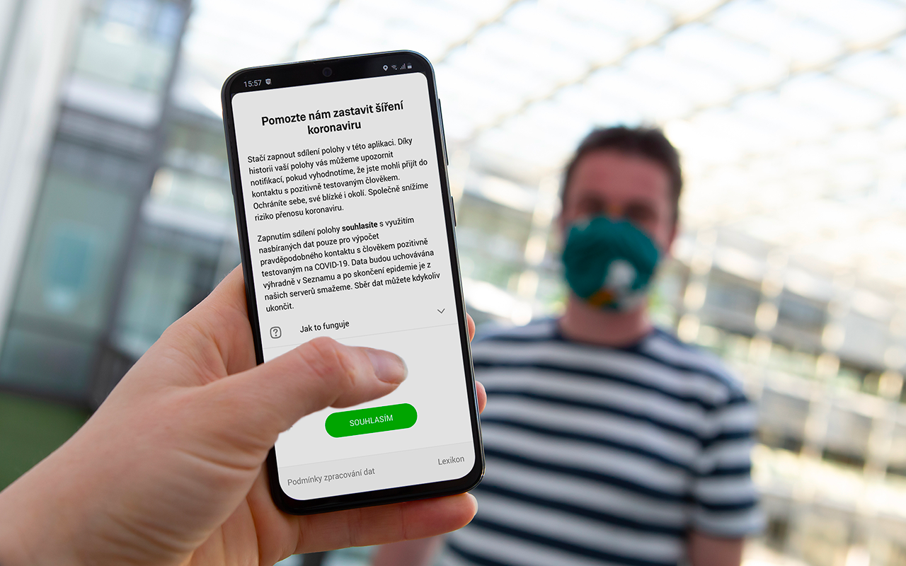
“Pomozte nám zastavit šíření koronaviru! Stačí zapnout sdílení polohy v aplikaci Mapy.cz.” přesně takto lákají Mapy.cz na novou funkci, která pracuje s historií Vaší polohy a případnou historií polohy nakažených obyvatel. Pokud Vás hned napadne, že to asi nebude tak jednoduché, a co na to GDPR, tak přemýšlíte správně. Aplikace bude zpracovávat anonymizovaná data o historii polohy […]
The post Mapy.cz bojují s COVID-19 appeared first on GISportal.cz.
Elektronická rezervace - pozastavení funkčnosti
23.3.2020 8:06 ČÚZK /Urady/Katastralni-urady/Katastralni-urady/Katastralni-urad-pro-Vysocinu/Katastralni-pracoviste/KP-Havlickuv-Brod/O-uradu/Aktuality/Elektronicka-rezervace-pozastaveni-funkcnostiElektronická rezervace - pozastavení funkčnosti
23.3.2020 8:06 ČÚZK - předpisy a opatření Katastrální úřad pro Vysočinu - Katastrální pracoviště Havlíčkův Brod zveřejnil novou aktualitu: Z důvodu omezení úředních hodin na katastrálním pracovišti byla dočasně vypnuta možnost objednání přes internet.Děkujeme za pochopení
Noví členové APG
23.3.2020 7:14 Asociace podnikatelů v geomatice Novými členy Asociace podnikatelů v geomatice se staly společnost Hanousek s.r.o., zastoupená jednatelem Ing. Davidem Dohnalem, a společnost AGROPLAN, spol. s r.o., zastoupená jednatelem panem Petrem Kubů. Počet členů Asociace podnikatelů v geomatice stále roste. Členství v APG má celou řadu výhod: + práce v pracovních skupinách + příležitost aktivně ovlivňovat dění + právní služby pro vaše podnikání + diskuse s kolegy […]DTM ČR ve výstavbě II
23.3.2020 7:00 Česká asociace pro geoinformace Přípomínáme blížící se seminář DTM ČR ve výstavbě II. Uskuteční se již 1. 4. 2020 formou webináře. Registrace je stále otevřenaAPGEO - NOVÍ ČLENOVÉ APG
23.3.2020 1:00 Asociace podnikatelů v geomatice Novými členy Asociace podnikatelů v geomatice se staly společnost Hanousek s.r.o., zastoupená jednatelem ..."Flattening the Curve" Analysis Added to U.S. Spread of COVID-19 Map
23.3.2020 0:11 GISCafe.com Webcasts-Webinars
St. Paul, Minnesota, March 22, 2020 – This afternoon, Minnesota based nonprofit SharedGeo updated its online COVID-19 …
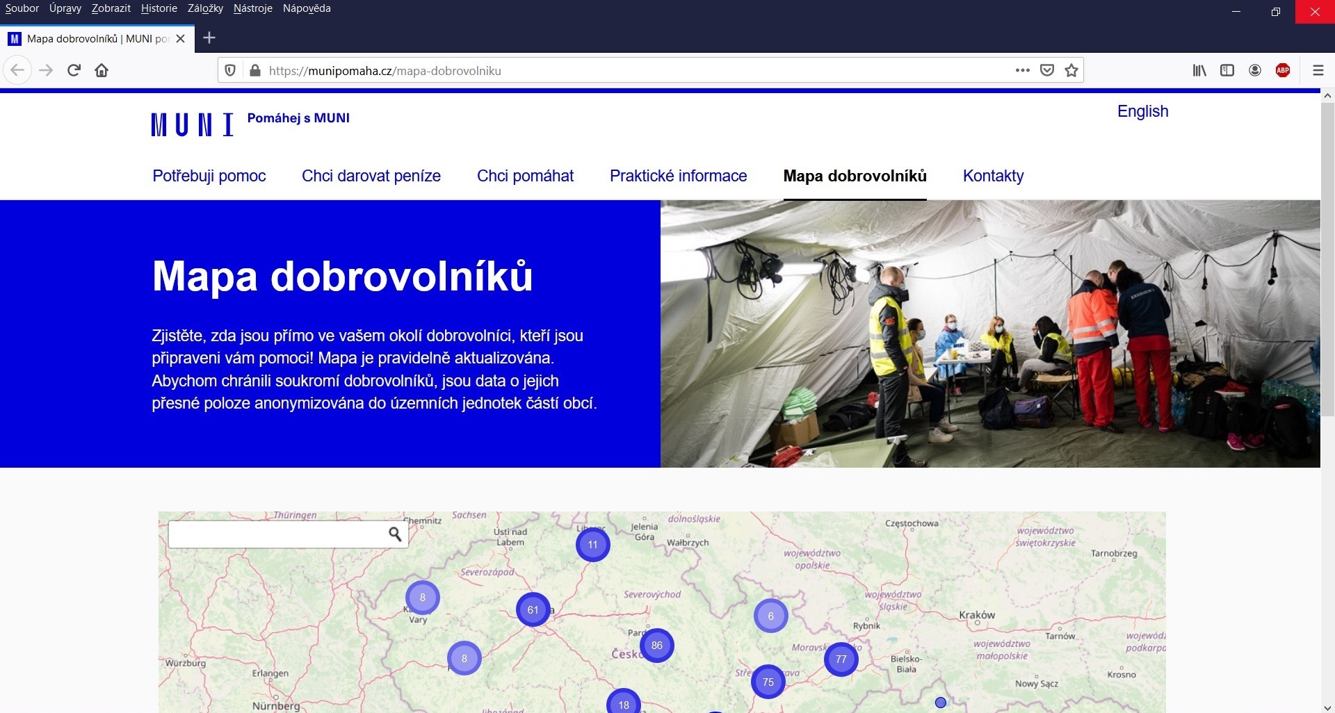
Na pomoci se zvládáním epidemie koronaviru se podílejí i studenti GÚ
23.3.2020 0:00 Geografický ústav MUMasarykova univerzita disponuje v současné době řadou dobrovolníků, zejména studentů, kteří jsou připraveni pomáhat se zvládáním epidemie koronaviru.
Na organizování této pomoci se podílí také studenti Geografického ústavu Jiří Hladík a Dajana Snopková, kteří spravují Mapu dobrovolníků, díky které je možno zjistit jejich aktuální počet na různých místech v rámci České republiky.
Připomeňte si svoji profesi. Dnes je mezinárodní den zeměměřičů
21.3.2020 10:57 ZeměměřičDnešní den, tedy 21. března, je již potřetí dnem, kdy si svoji profesi mohou oficiálně připomenout oslavou všichni zeměměřiči (a geodeti a geomatici). 21. březen je totiž mezinárodní den zeměměřičů (Global Surveyors‘ Day). Toto celosvětové připomenutí si naší profese poprvé vyhlásila Mezinárodní federace zeměměřičů (FIG) v roce 2018. Své fotografie, pokud budete chuť si naši profesi připomenout, nám posílejte na […]
The post Připomeňte si svoji profesi. Dnes je mezinárodní den zeměměřičů appeared first on Zeměměřič.
Předseda APG jednal s ministryní financí
21.3.2020 7:37 Asociace podnikatelů v geomatice Ministryně financí Alena Schillerová zavítala na Českolipsko, kde navštívila několik lokalit. Hlavní setkání se starostkou České Lípy Ing. Jitkou Volfovou se konalo v sídle Okresní hospodářské komory Česká Lípa ve Ville Hrdlička. Zde také proběhla diskuze představitelů samospráv a podnikatelské veřejnosti. V rámci diskuze předseda APG Martin Hrdlička vyzdvihl možnosti katastru nemovitostí jako zdroje informací nejen pro veřejnou […]Předseda APG jednal s ministryní financí
21.3.2020 7:37 Asociace podnikatelů v geomatice Ministryně financí Alena Schillerová zavítala na Českolipsko, kde navštívila několik lokalit. Hlavní setkání se starostkou České Lípy Ing. Jitkou Volfovou se konalo v sídle Okresní hospodářské komory Česká Lípa ve Ville Hrdlička. Zde také proběhla diskuze představitelů samospráv a podnikatelské veřejnosti. V rámci diskuze předseda APG Martin Hrdlička vyzdvihl možnosti katastru nemovitostí jako zdroje informací nejen pro […]USAFacts Coronavirus Data Hub and Map Tracking the Daily Spread of the Virus in Every U.S. County Is Now Live
21.3.2020 2:07 GISCafe.com Webcasts-Webinars Provides Easy Access to Trusted Data for Journalists, Civic Leaders and Members of the PublicBELLEVUE, Wash. — (BUSINESS WIRE) — March …
LiDAR Start-Up Blickfeld Closes Series A Financing Round With Participation of Continental and Wachstumsfonds Bayern
20.3.2020 21:34 GISCafe.com Webcasts-Webinars MUNICH — (BUSINESS WIRE) — March 20, 2020 —Munich-based LiDAR start-up Blickfeld has completed its Series A financing round. The …
GovPilot Makes Software Free During Crisis to Help Local Governments Combat COVID-19
20.3.2020 21:34 GISCafe.com Webcasts-Webinars GovPilot's cloud-based software will enable governments to deploy critical solutions and help non-essential government employees work remotely while …Opatrenia PPA na zníženie rizík podvodov pri podávaní žiadostí o priame podpory
20.3.2020 21:28 Komora pozemkových úprav SR
Pôdohospodárska platobná agentúra dáva do pozornosti žiadateľom o priame podpory na rok 2020 najčastejšie nedostatky a chyby, ktoré sa prejavujú v súvislosti s plnením podmienok poskytnutia podpory podľa Nariadenia vlády SR č. 342/2014 Z. z....
Opatrenia PPA na zníženie rizík podvodov pri podávaní žiadostí o priame podpory
20.3.2020 21:28 Komora pozemkových úprav SRPôdohospodárska platobná agentúra dáva do pozornosti žiadateľom o priame podpory na rok 2020 najčastejšie nedostatky a chyby, ktoré sa prejavujú v súvislosti s plnením podmienok poskytnutia podpory podľa Nariadenia vlády SR č. 342/2014 Z. z. Konkrétne plnením podmienky, podľa ktorej sa platby...
Celebrating the GNSS surveying community
20.3.2020 21:07 European GNSS Agency
The European GNSS Agency (GSA) joins the 2020 Global Surveyors Day, to celebrate the men and women of the surveying profession and their valuable work across a wide range of geomatics applications including land surveying (cadastral, construction, mapping and GIS, mining and infrastructure monitoring) and offshore surveying. The surveying industry and community have been an early adopter of Galileo and EGNOS leveraging on the high-precision positioning to develop new services and applications.
The geomatics community has always supported and trusted the European GNSS, and this is confirmed by the gradual penetration of Galileo in GNSS receivers for surveying and mapping. Currently around 55% of GNSS surveying receivers already support Galileo and around 90% are EGNOS-enabled. Moreover, most RTK providers in Europe have already upgraded to Galileo or are starting to do so, and major PPP and PPP-RTK providers are following their example.
The 2019 GSA GNSS Market Report highlights the benefits of GNSS for the geomatics community, noting that geomatics professionals already benefit from EGNSS in a multi-constellation environment, where it provides higher availability, continuity, reliability and better results in harsh conditions.
Watch this: EGNOS and Galileo for Mapping
“Geomatics is a key user segment for EGNSS, in which the added accuracy and reliability that Galileo and EGNOS bring to the table are a key driver of innovative services and solutions,” said GSA Head of Market Development Fiammetta Diani. “We are working continuously with this user community to understand their needs and requirements, so we can ensure that future EGNSS evolutions adequately reflect these needs,” she said.
Research and development
A number of Horizon 2020-funded research projects aim to harness the benefits of EGNSS in targeted geomatics solutions. One such project is GIMS, which is building an advanced low-cost system based on EGNSS, Copernicus Synthetic Aperture Radar (SAR) and other in-situ sensors to monitor ground deformations, with a focus on landslides and subsidence.
The project’s goal is to provide detailed and timely knowledge of the geophysical behaviour of parts of the Earth surface, and its impact on structures, in order to prevent injury to the public in the event of landslides, for instance, and to better plan preventative maintenance. The system will report deformations with millimetre-level accuracy and the integration of in-situ accelerometers will give real-time alerts in case of sudden movements.
Another project, GISCAD-OV, covers the entire cadastral value chain and aims to design, develop and validate an innovative and cost-effective High Accuracy Service (HAS) for Cadastral Surveying applications, based on GPS+Galileo E6 HAS and Precise Point Positioning-Ambiguity Resolution (PPP-AR) quick convergence techniques.
It will achieve this by upgrading commercial GNSS receivers for decoding and applying Galileo E6 corrections and integrating them into the PPP solution. It will also use PPP-RTK Multiple Constellation and Multiple Carrier Ambiguity Resolution and instantaneous fixing, along with cost effective solutions using low-cost augmentation services and receivers, paving the way for “Smartphone Surveying”.
Success stories
While ongoing research is set to deliver some exciting developments for the geomatics community, EGNSS is already being successfully used in the sector. One success story is at Eustream, the operator of a high-pressure gas transmission system in the Slovak Republic. The company operates gas pipelines with an overall length of 2,273 km, which are regularly inspected. The operator’s field operators use handheld GNSS devices to directly locate specific pipes with the required precision.
Read this: Galileo and EGNOS: supporting effective disaster management
“Our pipelines are routed through rural areas and there are sites with no GPRS coverage. EGNOS helps us to achieve the required precision and fulfil our task even without Internet connection,” said Branislav Reťkovský, head of Eustream’s GIS department. “For us, EGNOS means a reliable, open and free-of-charge back-up solution that brings confidence to our land survey practice,” he said.
The Portuguese Cycling Federation is also aware of the benefits that EGNOS has to offer and has recommended the use of EGNOS for the creation of cycling tracks and marking of paths, thanks to the higher-precision geolocation it offers, in its Regulation for the Homologation of cycling routes and ‘Cyclin’ Portugal’ Centres”.
Engaging with stakeholders
The GSA engages in a systematic process of consultation with the surveying community, and based on this consultation, it produces The Report on Surveying User Needs and Requirements, which can be downloaded here.
On the occasion of Global Surveyors Day, the GSA would like to congratulate the men and women of the surveying profession. We thank you for your dedicated service and we look forward to our ongoing mutually-beneficial cooperation in the future.
Media note: This feature can be republished without charge provided the European GNSS Agency (GSA) is acknowledged as the source at the top or the bottom of the story. You must request permission before you use any of the photographs on the site. If you republish, we would be grateful if you could link back to the GSA website (http://www.gsa.europa.eu).
Celebrating the GNSS surveying community
20.3.2020 21:07 European GNSS AgencyThe European GNSS Agency (GSA) joins the 2020 Global Surveyors Day, to celebrate the men and women of the surveying profession and their valuable work across a wide range of geomatics applications including land surveying (cadastral, construction, mapping and GIS, mining and infrastructure monitoring) and offshore surveying. The surveying industry and community have been an early adopter of Galileo and EGNOS leveraging on the high-precision positioning to develop new services and applications.
The geomatics community has always supported and trusted the European GNSS, and this is confirmed by the gradual penetration of Galileo in GNSS receivers for surveying and mapping. Currently around 55% of GNSS surveying receivers already support Galileo and around 90% are EGNOS-enabled. Moreover, most RTK providers in Europe have already upgraded to Galileo or are starting to do so, and major PPP and PPP-RTK providers are following their example.
The 2019 GSA GNSS Market Report highlights the benefits of GNSS for the geomatics community, noting that geomatics professionals already benefit from EGNSS in a multi-constellation environment, where it provides higher availability, continuity, reliability and better results in harsh conditions.
Watch this: EGNOS and Galileo for Mapping
“Geomatics is a key user segment for EGNSS, in which the added accuracy and reliability that Galileo and EGNOS bring to the table are a key driver of innovative services and solutions,” said GSA Head of Market Development Fiammetta Diani. “We are working continuously with this user community to understand their needs and requirements, so we can ensure that future EGNSS evolutions adequately reflect these needs,” she said.
Research and development
A number of Horizon 2020-funded research projects aim to harness the benefits of EGNSS in targeted geomatics solutions. One such project is GIMS, which is building an advanced low-cost system based on EGNSS, Copernicus Synthetic Aperture Radar (SAR) and other in-situ sensors to monitor ground deformations, with a focus on landslides and subsidence.
The project’s goal is to provide detailed and timely knowledge of the geophysical behaviour of parts of the Earth surface, and its impact on structures, in order to prevent injury to the public in the event of landslides, for instance, and to better plan preventative maintenance. The system will report deformations with millimetre-level accuracy and the integration of in-situ accelerometers will give real-time alerts in case of sudden movements.
Another project, GISCAD-OV, covers the entire cadastral value chain and aims to design, develop and validate an innovative and cost-effective High Accuracy Service (HAS) for Cadastral Surveying applications, based on GPS+Galileo E6 HAS and Precise Point Positioning-Ambiguity Resolution (PPP-AR) quick convergence techniques.
It will achieve this by upgrading commercial GNSS receivers for decoding and applying Galileo E6 corrections and integrating them into the PPP solution. It will also use PPP-RTK Multiple Constellation and Multiple Carrier Ambiguity Resolution and instantaneous fixing, along with cost effective solutions using low-cost augmentation services and receivers, paving the way for “Smartphone Surveying”.
Success stories
While ongoing research is set to deliver some exciting developments for the geomatics community, EGNSS is already being successfully used in the sector. One success story is at Eustream, the operator of a high-pressure gas transmission system in the Slovak Republic. The company operates gas pipelines with an overall length of 2,273 km, which are regularly inspected. The operator’s field operators use handheld GNSS devices to directly locate specific pipes with the required precision.
Read this: Galileo and EGNOS: supporting effective disaster management
“Our pipelines are routed through rural areas and there are sites with no GPRS coverage. EGNOS helps us to achieve the required precision and fulfil our task even without Internet connection,” said Branislav Reťkovský, head of Eustream’s GIS department. “For us, EGNOS means a reliable, open and free-of-charge back-up solution that brings confidence to our land survey practice,” he said.
The Portuguese Cycling Federation is also aware of the benefits that EGNOS has to offer and has recommended the use of EGNOS for the creation of cycling tracks and marking of paths, thanks to the higher-precision geolocation it offers, in its Regulation for the Homologation of cycling routes and ‘Cyclin’ Portugal’ Centres”.
Engaging with stakeholders
The GSA engages in a systematic process of consultation with the surveying community, and based on this consultation, it produces The Report on Surveying User Needs and Requirements, which can be downloaded here.
On the occasion of Global Surveyors Day, the GSA would like to congratulate the men and women of the surveying profession. We thank you for your dedicated service and we look forward to our ongoing mutually-beneficial cooperation in the future.
Media note: This feature can be republished without charge provided the European GNSS Agency (GSA) is acknowledged as the source at the top or the bottom of the story. You must request permission before you use any of the photographs on the site. If you republish, we would be grateful if you could link back to the GSA website (http://www.gsa.europa.eu).
A Note from the President’s Desk | March 2020
20.3.2020 20:20 Carlson Software Response to COVID-19 It is times like this when we at Carlson Software feel especially fortunate to be working with the land surveying, mining and construction industries. All involve field work, fresh air and almost built-in “social distancing”. Work takes place on construction sites, at wind-swept mines, in woods, fields and subdivisions, away from large gatherings in […]Satellite Imagery: COVID-19 testing facilities in Munich, Germany
20.3.2020 18:35 GISCafe.com Webcasts-Webinars European Space Imaging collected imagery yesterday afternoon (March 19 2020) of the COVID-19 drive-through testing facilities currently erected at …Důležitý patch pro Portal for ArcGIS 10.7.1
20.3.2020 13:40 ARCDATASpolečnost Esri vydala nový patch pro Portal for ArcGIS 10.7.1 – High Availability Licensing Patch. Kromě toho, že nový patch řeší problémy s licencováním v Portálech, které musí zajišťovat vysokou uživatelskou dostupnost, slouží také jako náhrada za již dříve vydaný Portal for ArcGIS 10.7.1 Security Patch 2019 Update 2 Patch, u kterého bylo zjištěno, že v některých případech může způsobit nesprávnou instalaci následných patchů.
Důrazně doporučujeme všem, kteří si nainstalovali patch Portal for ArcGIS 10.7.1 Security Patch 2019 Update 2 Patch, aby si co nejdříve stáhli a nainstalovali patch nový Portal for ArcGIS 10.7.1 High Availability Licensing Patch a vyhnuli se tak případným problémům, které mohou souviset s nesprávnou instalací následně nově vydaných oprav (patche, hot-fixy). U klientů s operačním systémem Windows může instalace této opravy trvat déle, jelikož musí nejprve dojít k odinstalování staršího patche. Uživatelů s operačním systémem Linux se toto omezení netýká. Nový patch zároveň obsahuje veškeré opravy, které byly součástí původní opravy Portal for ArcGIS 10.7.1 Security Patch 2019 Update 2 Patch.
Úplný seznam chyb, které nový Portal for ArcGIS 10.7.1 High Availability Licensing Patch řeší, a instalační soubor patche můžete najít na stránce opravy.
Upozornění
20.3.2020 13:20 ČÚZK - předpisy a opatření Český úřad zeměměřický a katastrální - Katastrální pracoviště Slaný zveřejnil novou aktualitu: Podání můžete učinit bezkontaktně do schránky umístěné u vchodu do budovy.Lze tak podat i návrh na vklad v zalepené obálce.
V podání uveďte Váš e-mail, budeme Vás informovat o přijetí a případně Vás vyzveme k zaplacení poplatku převodem na účet.
Pokud budete podávat více podání, označte jejich pořadí.
Dále upozorňujeme na možnost elektronického podání s využítím datové schránky. Taková podání musí být převedena z analogové do elektronické pdoby s využitím autorizované konverze dokumentu, opatřena značkou subjektu nebo elektronickým podpisem osoby, která konverzi provedla, a výstup opatřen kvalifikovaným časovým razítkem a musí být zaslán prostřednictvím datové schránky )častníka řízení nebo jeho zástupce (vše na www.cuzk.cz)
Upozornění
20.3.2020 13:20 ČÚZK /Urady/Katastralni-urady/Katastralni-urady/Katastralni-urad-pro-Stredocesky-kraj/Katastralni-pracoviste/KP-Slany/O-uradu/Aktuality/UpozorneniMožnost bezkontaktního podání
20.3.2020 13:20 ČÚZK - předpisy a opatření Katastrální úřad pro Královéhradecký kraj - Katastrální pracoviště Rychnov nad Kněžnou zveřejnil novou aktualitu: Možnost bezkontaktního podáníUpozorňujeme na možnost učinit podání bezkontaktně do schránky umístěné ve vchodu do budovy katastrálního pracoviště!
Lze tak podat i návrh na vklad v zalepené obálce. Obálku označte názvem příslušného úřadu. Uveďte v podání Váš email, budeme Vás informovat o přijetí, případně vyzveme k zaplacení poplatku převodem na účet.
Schránka je přístupná každý pracovní den od 8 do 13 hod.
Schránku pravidelně vybíráme!
Pokud budete podávat více podání, označte prosím jejich pořadí.
podrobnosti viz celé oznámení
Možnost bezkontaktního podání
20.3.2020 13:20 ČÚZK - předpisy a opatření Katastrální úřad pro Královéhradecký kraj - Katastrální pracoviště Rychnov nad Kněžnou zveřejnil novou aktualitu: Možnost bezkontaktního podáníUpozorňujeme na možnost učinit podání bezkontaktně do schránky umístěné ve vchodu do budovy katastrálního pracoviště!
Lze tak podat i návrh na vklad v zalepené obálce. Obálku označte názvem příslušného úřadu. Uveďte v podání Váš email, budeme Vás informovat o přijetí, případně vyzveme k zaplacení poplatku převodem na účet.
Schránka je přístupná pondělí a středa od 8 do 17 hod a úterý, čtvrtek a pátek od 8 do 13 hod.
Schránku pravidelně vybíráme!
Pokud budete podávat více podání, označte prosím jejich pořadí.
PODROBNOSTI VE SDĚLENÍ
Možnost bezkontaktního podání
20.3.2020 13:20 ČÚZK - předpisy a opatření Katastrální úřad pro Královéhradecký kraj - Katastrální pracoviště Rychnov nad Kněžnou zveřejnil novou aktualitu: Možnost bezkontaktního podáníUpozorňujeme na možnost učinit podání bezkontaktně do schránky umístěné ve vchodu do budovy katastrálního pracoviště!
Lze tak podat i návrh na vklad v zalepené obálce. Obálku označte názvem příslušného úřadu. Uveďte v podání Váš email, budeme Vás informovat o přijetí, případně vyzveme k zaplacení poplatku převodem na účet.
Schránka je přístupná každý pracovní den od 8 do 13 hod.
Schránku pravidelně vybíráme!
Pokud budete podávat více podání, označte prosím jejich pořadí.
PODROBNOSTI VE SDĚLENÍ
Možnost bezkontaktního podání
20.3.2020 13:20 ČÚZK /Urady/Katastralni-urady/Katastralni-urady/Katastralni-urad-pro-Kralovehradecky-kraj/Katastralni-pracoviste/KP-Rychnov-nad-Kneznou/O-uradu/Aktuality/Moznost-bezkontaktniho-podaniSchránka na návrhy
20.3.2020 12:24 ČÚZK - předpisy a opatření Katastrální úřad pro Středočeský kraj - Katastrální pracoviště Benešov zveřejnil novou aktualitu:Upozorňujeme na možnost učinit podání bezkontaktně do schránky umístěné u vchodu do budovy (vstupní mezidveří)! Lze tak podat i návrh na vklad v zalepené obálce. Uveďte v podání Váš mail, budeme Vás informovat o přijetí, případně vyzveme k zaplacení poplatku převodem na účet. Schránka je přístupná v pracovní dny od 7 do 15 hod.
Schránka na návrhy
20.3.2020 12:24 ČÚZK /Urady/Katastralni-urady/Katastralni-urady/Katastralni-urad-pro-Stredocesky-kraj/Katastralni-pracoviste/KP-Benesov/O-uradu/Aktuality/Schranka-na-navrhySchránka na návrhy
20.3.2020 12:24 ČÚZK - předpisy a opatření Katastrální úřad pro Středočeský kraj - Katastrální pracoviště Benešov zveřejnil novou aktualitu: Upozorňujeme na možnost učinit podání bezkontaktně do schránky umístěné u vchodu do budovy (vstupní mezidveří)! Lze tak podat i návrh na vklad v zalepené obálce. Uveďte v podání Váš mail, budeme Vás informovat o přijetí, případně vyzveme k zaplacení poplatku převodem na účet. Schránka je přístupná v pracovní dny od 7 do 15 hod.Land-cover maps of Europe from the Cloud
20.3.2020 11:30 ESA Observing the Earth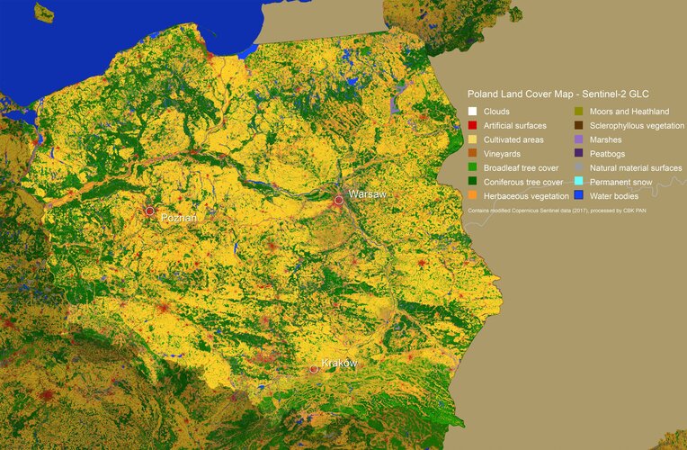
Earth’s land is covered by a range of different types of vegetation, from forest and marsh to crops and bodies of water, as well as the artificial surfaces that are an increasingly common feature of our landscape.
Možnost bezkontaktního podání
20.3.2020 11:14 ČÚZK - předpisy a opatření Katastrální úřad pro Jihomoravský kraj zveřejnil novou aktualitu: Možnost bezkontaktního podáníPřestože jsou v souladu s usnesením vlády č. 217 ze dne 15. března 2020 úřední hodiny pro veřejnost pouze v pondělí a středu od 8,00 do 11,00 hod., je možné i mimo tyto úřední hodiny vhodit podání v zalepené obálce do uzavřeného sběrného boxu, který je umístěn vždy u vstupu do budovy příslušného katastrálního pracoviště. Box je zpřístupněn v běžných úředních hodinách. Pokud bude v podání uvedena e-mailová adresa, bude na ní zasláno potvrzení o přijetí podání. Za okamžik podání návrhu na vklad se považuje okamžik výběru sběrného boxu. V případě, že je s podáním spojena poplatková povinnost, bude účastníkům zaslána i výzva k úhradě správního poplatku převodem na účet. Děkujeme, že budete v co největší míře využívat této zcela bezkontaktní možnosti.
Možnost bezkontaktního podání
20.3.2020 11:14 ČÚZK /Urady/Katastralni-urady/Katastralni-urady/Katastralni-urad-pro-Jihomoravsky-kraj/O-uradu/Aktuality/Moznost-bezkontaktniho-podani-(1)Možnost bezkontaktního podání
20.3.2020 11:13 ČÚZK - předpisy a opatření Katastrální úřad pro Jihomoravský kraj - Katastrální pracoviště Břeclav zveřejnil novou aktualitu: Možnost bezkontaktního podáníPřestože jsou v souladu s usnesením vlády č. 217 ze dne 15. března 2020 úřední hodiny pro veřejnost pouze v pondělí a středu od 8,00 do 11,00 hod., je možné i mimo tyto úřední hodiny vhodit podání v zalepené obálce do uzavřeného sběrného boxu, který je umístěn vždy u vstupu do budovy příslušného katastrálního pracoviště. Box je zpřístupněn v běžných úředních hodinách. Pokud bude v podání uvedena e-mailová adresa, bude na ní zasláno potvrzení o přijetí podání. Za okamžik podání návrhu na vklad se považuje okamžik výběru sběrného boxu. V případě, že je s podáním spojena poplatková povinnost, bude účastníkům zaslána i výzva k úhradě správního poplatku převodem na účet. Děkujeme, že budete v co největší míře využívat této zcela bezkontaktní možnosti.
Možnost bezkontaktního podání
20.3.2020 11:13 ČÚZK /Urady/Katastralni-urady/Katastralni-urady/Katastralni-urad-pro-Jihomoravsky-kraj/Katastralni-pracoviste/KP-Breclav/O-uradu/Aktuality/Moznost-bezkontaktniho-podani20200320 - Probíhající opravy/doplnění mluvnických charakteristik
20.3.2020 10:23 ČÚZK - předpisy a opatření Oznámení pro uživatele VFR:U obcí bude postupně probíhat oprava/doplnění mluvnických charakteristik (skloňování názvů) dle podkladů od Ústavu pro jazyk český, což se projeví změnou v souborech VFR. Lze tedy očekávat zvýšený výskyt změn obcí ve změnových souborech. Následně budou tyto opravy/doplnění probíhat pro části obce, MOMC a katastrální území.
Zveřejněno 20. 3. 2020
20200320 - Probíhající opravy/doplnění mluvnických charakteristik
20.3.2020 10:23 ČÚZK - předpisy a opatření Oznámení pro uživatele VFR:U obcí bude postupně probíhat oprava/doplnění mluvnických charakteristik (skloňování názvů) dle podkladů od Ústavu pro jazyk český, což se projeví změnou v souborech VFR. Lze tedy očekávat zvýšený výskyt změn obcí ve změnových souborech. Následně budou tyto opravy/doplnění probíhat pro části obce, MOMC a katastrální území.
(Ukázka doplňovaných dublet/dvojtvarů: „Semicím; Semicům“)
Zveřejněno 20. 3. 2020
20200320 - Probíhající opravy/doplnění mluvnických charakteristik
20.3.2020 10:23 ČÚZK - předpisy a opatření Oznámení pro uživatele VFR:U obcí bude postupně probíhat oprava/doplnění mluvnických charakteristik (skloňování názvů) dle podkladů od Ústavu pro jazyk český, což se projeví změnou v souborech VFR. Lze tedy očekávat zvýšený výskyt změn obcí ve změnových souborech. Následně budou tyto opravy/doplnění probíhat pro části obce, MOMC a katastrální území.
(Ukázky doplňovaných dublet/dvojtvarů: „Semicím; Semicům“, „Životicím/Životicům u Nového Jičína“)
Zveřejněno 20. 3. 2020
20200320 - Probíhající opravy/doplnění mluvnických charakteristik
20.3.2020 10:23 ČÚZK /Uvod/Produkty-a-sluzby/RUIAN/2-Poskytovani-udaju-RUIAN-ISUI-VDP/Vymenny-format-RUIAN/Archiv-novinek-VFR/20200320-Probihajici-opravy-doplneni-mluvnickychOdborný/vrchní referent - obnova katastrálního operátu OKO0324
20.3.2020 10:14 ČÚZK - volná místa Katastrální úřad pro Plzeňský kraj vypisuje výběrové řízení na místo Odborný/vrchní referent - obnova katastrálního operátu OKO0324Odborný/vrchní referent - obnova katastrálního operátu OKO0324
20.3.2020 10:14 ČÚZK /Urady/Katastralni-urady/Katastralni-urady/Katastralni-urad-pro-Plzensky-kraj/Uredni-deska/Oznameni-a-jina-uredni-sdeleni/Volna-mista/DMS/5-Ozn-o-vyhl-vyberoveho-rizeni-OOKOOdborný/vrchní referent - obnova katastrálního operátu OKO0324
20.3.2020 10:14 ČÚZK - předpisy a opatření Katastrální úřad pro Plzeňský krajvypisuje výběrové řízení na místo
Odborný/vrchní referent - obnova katastrálního operátu OKO0324
Kuwait
20.3.2020 10:00 ESA Observing the Earth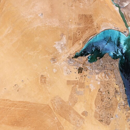 Image:
The Copernicus Sentinel-2 mission takes us over Kuwait in the Middle East.
Image:
The Copernicus Sentinel-2 mission takes us over Kuwait in the Middle East.
Earth from Space: Kuwait
20.3.2020 10:00 ESA Observing the Earth Video:
00:03:36
Video:
00:03:36
In this week's edition of the Earth from Space programme, the Copernicus Sentinel-2 mission takes us over Kuwait in the Middle East.
See also Kuwait to download the image.
Možnost bezkontaktního podání
20.3.2020 9:12 ČÚZK - předpisy a opatření Katastrální úřad pro Jihomoravský kraj - Katastrální pracoviště Boskovice zveřejnil novou aktualitu: Možnost bezkontaktního podáníPřestože jsou v souladu s usnesením vlády č. 217 ze dne 15. března 2020 úřední hodiny pro veřejnost pouze v pondělí a středu od 8,00 do 11,00 hod., je možné i mimo tyto úřední hodiny vhodit podání v zalepené obálce do uzavřeného sběrného boxu, který je umístěn vždy u vstupu do budovy příslušného katastrálního pracoviště. Box je zpřístupněn v běžných úředních hodinách. Pokud bude v podání uvedena e-mailová adresa, bude na ní zasláno potvrzení o přijetí podání. Za okamžik podání návrhu na vklad se považuje okamžik výběru sběrného boxu. V případě, že je s podáním spojena poplatková povinnost, bude účastníkům zaslána i výzva k úhradě správního poplatku převodem na účet. Děkujeme, že budete v co největší míře využívat této zcela bezkontaktní možnosti.
Možnost bezkontaktního podání
20.3.2020 9:12 ČÚZK /Urady/Katastralni-urady/Katastralni-urady/Katastralni-urad-pro-Jihomoravsky-kraj/Katastralni-pracoviste/KP-Boskovice/O-uradu/Aktuality/Moznost-bezkontaktniho-podaniKoronavirus v českých mapách
20.3.2020 8:13 GISportal.cz
Po příspěvku Coronavirus v grafech, mapách a dashboardech, který se soustředil především na zahraniční mapy a vizualizace, přinášíme přehled některých map s českou tématikou. Pokud víte o podobné mapě či projektu, napište nám, rádi projekt zveřejníme! Mobilní Rozhlas je mobilní i webová aplikace, která slouží pro komunikaci mezi radnicí a občany. Firma již dříve oznámila, […]
The post Koronavirus v českých mapách appeared first on GISportal.cz.
Možnost bezkontaktního podání
20.3.2020 8:10 ČÚZK /Urady/Katastralni-urady/Katastralni-urady/Katastralni-urad-pro-Jihomoravsky-kraj/Katastralni-pracoviste/KP-Blansko/O-uradu/Aktuality/Moznost-bezkontaktniho-podaniMožnost bezkontaktního podání
20.3.2020 8:10 ČÚZK - předpisy a opatření Katastrální úřad pro Jihomoravský kraj - Katastrální pracoviště Blansko zveřejnil novou aktualitu: Možnost bezkontaktního podáníPřestože jsou v souladu s usnesením vlády č. 217 ze dne 15. března 2020 úřední hodiny pro veřejnost pouze v pondělí a středu od 8,00 do 11,00 hod., je možné i mimo tyto úřední hodiny vhodit podání v zalepené obálce do uzavřeného sběrného boxu, který je umístěn vždy u vstupu do budovy příslušného katastrálního pracoviště. Box je zpřístupněn v běžných úředních hodinách. Pokud bude v podání uvedena e-mailová adresa, bude na ní zasláno potvrzení o přijetí podání. Za okamžik podání návrhu na vklad se považuje okamžik výběru sběrného boxu. V případě, že je s podáním spojena poplatková povinnost, bude účastníkům zaslána i výzva k úhradě správního poplatku převodem na účet. Děkujeme, že budete v co největší míře využívat této zcela bezkontaktní možnosti.
Delair and BASF collaborate to accelerate research for agricultural solutions
20.3.2020 8:00 GISCafe.com Webcasts-Webinars Visual intelligence platform from Delair to support agricultural research projects of BASF worldwideDelair.ai platform to streamline and create …
Výsledky GISáček 2020
20.3.2020 7:00 Česká asociace pro geoinformace Výsledky studentské soutěže GISáček 2020: https://gisak.vsb.cz/gisostrava/cz/gisacek/vysledky_souteze_2020.pdfMožnost bezkontaktního podání
20.3.2020 6:58 ČÚZK - předpisy a opatření Katastrální úřad pro Jihomoravský kraj - Katastrální pracoviště Brno-venkov zveřejnil novou aktualitu: Možnost bezkontaktního podáníPřestože jsou v souladu s usnesením vlády č. 217 ze dne 15. března 2020 úřední hodiny pro veřejnost pouze v pondělí a středu od 8,00 do 11,00 hod., je možné i mimo tyto úřední hodiny vhodit podání v zalepené obálce do uzavřeného sběrného boxu, který je umístěn vždy u vstupu do budovy příslušného katastrálního pracoviště. Box je zpřístupněn v běžných úředních hodinách. Pokud bude v podání uvedena e-mailová adresa, bude na ní zasláno potvrzení o přijetí podání. Za okamžik podání návrhu na vklad se považuje okamžik výběru sběrného boxu. V případě, že je s podáním spojena poplatková povinnost, bude účastníkům zaslána i výzva k úhradě správního poplatku převodem na účet. Děkujeme, že budete v co největší míře využívat této zcela bezkontaktní možnosti.
Možnost bezkontaktního podání
20.3.2020 6:58 ČÚZK /Urady/Katastralni-urady/Katastralni-urady/Katastralni-urad-pro-Jihomoravsky-kraj/Katastralni-pracoviste/KP-Brno-venkov/O-uradu/Aktuality/Moznost-bezkontaktniho-podaniMožnost bezkontaktního podání
20.3.2020 6:57 ČÚZK /Urady/Katastralni-urady/Katastralni-urady/Katastralni-urad-pro-Jihomoravsky-kraj/Katastralni-pracoviste/KP-Hustopece/O-uradu/Aktuality/Moznost-bezkontaktniho-podaniMožnost bezkontaktního podání
20.3.2020 6:57 ČÚZK - předpisy a opatření Katastrální úřad pro Jihomoravský kraj - Katastrální pracoviště Hustopeče zveřejnil novou aktualitu: Možnost bezkontaktního podáníPřestože jsou v souladu s usnesením vlády č. 217 ze dne 15. března 2020 úřední hodiny pro veřejnost pouze v pondělí a středu od 8,00 do 11,00 hod., je možné i mimo tyto úřední hodiny vhodit podání v zalepené obálce do uzavřeného sběrného boxu, který je umístěn vždy u vstupu do budovy příslušného katastrálního pracoviště. Box je zpřístupněn v běžných úředních hodinách. Pokud bude v podání uvedena e-mailová adresa, bude na ní zasláno potvrzení o přijetí podání. Za okamžik podání návrhu na vklad se považuje okamžik výběru sběrného boxu. V případě, že je s podáním spojena poplatková povinnost, bude účastníkům zaslána i výzva k úhradě správního poplatku převodem na účet. Děkujeme, že budete v co největší míře využívat této zcela bezkontaktní možnosti.
Možnost bezkontaktního podání
20.3.2020 6:55 ČÚZK - předpisy a opatření Katastrální úřad pro Jihomoravský kraj - Katastrální pracoviště Hodonín zveřejnil novou aktualitu: Možnost bezkontaktního podáníPřestože jsou v souladu s usnesením vlády č. 217 ze dne 15. března 2020 úřední hodiny pro veřejnost pouze v pondělí a středu od 8,00 do 11,00 hod., je možné i mimo tyto úřední hodiny vhodit podání v zalepené obálce do uzavřeného sběrného boxu, který je umístěn vždy u vstupu do budovy příslušného katastrálního pracoviště. Box je zpřístupněn v běžných úředních hodinách. Pokud bude v podání uvedena e-mailová adresa, bude na ní zasláno potvrzení o přijetí podání. Za okamžik podání návrhu na vklad se považuje okamžik výběru sběrného boxu. V případě, že je s podáním spojena poplatková povinnost, bude účastníkům zaslána i výzva k úhradě správního poplatku převodem na účet. Děkujeme, že budete v co největší míře využívat této zcela bezkontaktní možnosti.
Možnost bezkontaktního podání
20.3.2020 6:55 ČÚZK /Urady/Katastralni-urady/Katastralni-urady/Katastralni-urad-pro-Jihomoravsky-kraj/Katastralni-pracoviste/KP-Hodonin/O-uradu/Aktuality/Moznost-bezkontaktniho-podaniKatastrální mapa v rastrové podobě poskytovaná v e-shopu
20.3.2020 1:00 Cenia - Katalog metadat ČR - INSPIRE Katastrální mapa v rastrové podobě je poskytována za úplatu a obsahuje analogovou mapu s kompletní kresbou. Analogová mapa pokrývá 3,07 % území České republiky, což je 2 423,90km2. Více katastrální vyhláška č.357/2013 Sb. v platném znění.INSPIRE téma Budovy (BU)
20.3.2020 1:00 Cenia - Katalog metadat ČR - INSPIRE Data odpovídají směrnici INSPIRE pro téma budovy (BU). Data pochází částečně z projektu RÚIAN (Registr územní identifikace, adres a nemovitostí), který je součástí základních registrů České Republiky a obsahuje informace o územní identifikaci, adresách a nemovitostech, a částečně z ISKN (Informační systém katastru nemovistostí). Zdrojem informací o budovách v ISKN je objekt Stavba, v RÚIAN je to Stavební objekt. Většina Staveb je zároveň Stavebními objekty, ale jsou případy, kdy tomu tak není. Kromě Budov datová sada obsahuje i části budov, které jsou pro potřeby INSPIRE vyjádřeny vchody z RÚIAN. Vchody obsahují informace o počtu podlaží, technickoekonomických atributech apod. Datová sada pokrývá celé území české republiky. V datové sadě není uvedeno 1,15%, t.j. 48458 budov (k 16. 03. 2020), protože neobsahují definiční bod ani polygon. Více v zákoně č. 111/2009 Sb., o základních registrech, ve vyhlášce č. 359/2011 Sb., o základním registru územní identifikace, adres a nemovitostí v platných zněních, v zákoně 256/2013 Sb., o katastru nemovitostí, v katastrální vyhlášce č. 357/2013 Sb. v platném znění a INSPIRE Data Specification on Buildings v 3.0 z 13.12.2013. Data ve formátu GML 3.2.1 jsou validní proti schématu XML pro INSPIRE téma Budovy ve verzi 4.0 a proti schématu pro prostorová data ELF ve verzi 1.0.INSPIRE téma Rozšířené Parcely (CPX)
20.3.2020 1:00 Cenia - Katalog metadat ČR - INSPIRE Rozšíření má za cíl poskytovat katastrální mapu s obsahem podle vyhlášky ve vektorové podobě ve struktuře plně v souladu se strukturou danou směrnicí INSPIRE. Data rozšiřují směrnici INSPIRE pro téma katastrální parcely (CP) o věcná břemena, geodetické body, další prvky mapy, původní obloukovou geometrii a o parcely určené definičním bodem (ty pouze v oblastech s analogovou mapou). Vychází z katastrální mapy, která je závazným státním mapovým dílem velkého měřítka, obsahuje body polohového bodového pole, polohopis a popis a může mít formu digitální mapy, analogové mapy nebo digitalizované mapy. Publikovaná data obsahují katastrální území pro celou Českou Republiku, parcely a jejich hranice, věcná břemena, další prvky mapy a původní obloukovou geometrii z území, kde je digitální mapa (k 16. 03. 2020 je to 96,69% území České republiky, t.j. 76 257,96km2) a ve zbytku území katastrální parcely určené pouze definičním bodem (tedy bez hranic a polygonu). Katastrální parcely a hranice obsahují oproti datové sadě INSPIRE některé atributy navíc. Jedná se o typ hranice, způsob využití území, druh pozemku, vazbu na budovu a o mapové značky. Více katastrální zákon 344/1992 SB., katastrální vyhláška č.26/2007 Sb. v platném znění a INSPIRE Data Specification on Cadastral Parcels v 3.0.1. Data ve formátu GML 3.2.1 jsou validní proti schématu XML pro Rozšířené Parcely (CPX) ve verzi 4.0.Katastrální mapa ve formátech DGN a DXF poskytovaná v e-shopu
20.3.2020 1:00 Cenia - Katalog metadat ČR - INSPIRE Katastrální mapa je závazným státním mapovým dílem velkého měřítka, obsahuje body polohového bodového pole, polohopis a popis. Katastrální mapa ve vektorové podobě je poskytována zdarma ve formátu DGN a DXF a obsahuje prvky Digitální katastrální mapy (DKM) a Katastrální mapy digitalizované (KMD), tedy bodová pole, budovy, další prvky mapy, hranice parcel, katastrální hranice, parcely katastru nemovitostí, prvky orientační mapy a hranice věcného břemene. Z důvodu použití formátu DGN produkt neobsahuje značky na liniích a oblouky jsou nahrazeny lomenými čárami. Katastrální mapa ve vektorové podobě k 16. 03. 2020 pokrývá 96,69% území České republiky, t.j. 76 257,96km2. Více katastrální vyhláška č.357/2013 Sb. v platném znění.INSPIRE téma Adresy (AD)
20.3.2020 1:00 Cenia - Katalog metadat ČR - INSPIRE Data odpovídají směrnici INSPIRE pro téma adresy (AD). Vychází především z projektu RÚIAN (Registr územní identifikace, adres a nemovitostí), který je součástí základních registrů České Republiky a obsahuje informace o územní identifikaci, adresách a nemovitostech. Data publikovaná v rámci INSPIRE obsahují pouze adresní místa a jejich komponenty, kterými jsou stát, obec, část obce, městský obvod v Praze (MOP), městký obvod/městská část (MO/MČ), ulice a pošta a to na území celé České Republiky. Obsahují rozvněž geometrii, která určuje definiční bod adresního místa. V datové sadě nění uvedeno 1,19%, t.j. 34913 adresních míst (k 16. 03. 2020), protože neobsahují definiční bod, podle kterého by je bylo možné prostorově určit. Více v zákoně č. 111/2009 Sb., o základních registrech a ve vyhlášce č. 359/2011 Sb., o základním registru územní identifikace, adres a nemovitostí v platných zněních a INSPIRE Data Specification on Addresses v 3.0.1 z 26.4.2010. Data ve formátu GML 3.2.1 jsou validní proti schématu XML pro INSPIRE téma Adresy ve verzi 4.0 a proti schématu pro prostorová data ELF ve verzi 1.0.INSPIRE téma Parcely (CP)
20.3.2020 1:00 Cenia - Katalog metadat ČR - INSPIRE Data odpovídají směrnici INSPIRE pro téma katastrální parcely (CP). Vychází z katastrální mapy, která je závazným státním mapovým dílem velkého měřítka, obsahuje body polohového bodového pole, polohopis a popis a může mít formu digitální mapy, analogové mapy nebo digitalizované mapy. Data publikovaná v rámci INSPIRE obsahují pouze katastrální území (pro celou Českou Republiku) a parcely a jejich hranice z území, kde je digitální mapa (k 16. 03. 2020 je to 96,69% území České republiky, t.j. 76 257,96km2). Více katastrální zákon 344/1992 SB., katastrální vyhláška č.26/2007 Sb. v platném znění a INSPIRE Data Specification on Cadastral Parcels v 3.0.1. Data ve formátu GML 3.2.1 jsou validní proti schématu XML pro INSPIRE téma Parcely ve verzi 4.0 a proti schématu pro prostorová data ELF ve verzi 1.0.Výsledky studentské soutěže GISáček 2020
20.3.2020 0:07 GeoBusinessStudentská soutěžní konference GISáček 2020 se letos uskutečnila 18. března, tentokrát kvůli koronaviru formou videokonference. Soutěže se mohou zúčastnit všichni studenti vysokých škol, kteří na konferenci mohou představit výsledky svých prací, magisterských i bakalářských. Vítězové magisterské kategorie 1. místo: Jakub Seidl, VŠB-TU Ostrava: Využití bezpilotních leteckých prostředků pro monitoring svahových pohybů 2. místo: Přemysl Dratva, […]
The post Výsledky studentské soutěže GISáček 2020 appeared first on GeoBusiness.
Pobočka Jihlava obdržela pochvalu od obce Vílanec
20.3.2020 0:00 Státní pozemkový úřad Praha, 20. března 2020: Ústřední ředitel Státního pozemkového úřadu obdržel další oceněné pracovníků. Tentokrát pochvalu obdrželi pracovníci Pobočky Jihlava za spolupráci s vedením obce Vílanec.Pozastavení činností v řízení o pozemkových úpravách
20.3.2020 0:00 Státní pozemkový úřad Do odvolání jsou pozastaveny činnosti všech pracovišť související s nutností osobních aktivit účastníků řízení o pozemkových úpravách.Pozastavení činností v řízení o pozemkových úpravách
20.3.2020 0:00 Státní pozemkový úřad Do odvolání jsou pozastaveny činnosti všech pracovišť související s nutností osobních aktivit účastníků řízení o pozemkových úpravách.Výsledky studentské soutěže GISáček 2020
19.3.2020 22:03 Přestože letos studentská konference GISáček 2020 změnila na poslední chvíli svou formu z prezenční na videokonferenci, zúčastnilo se jí téměř 70 posluchačů. Přínosem této podoby byla především živá diskuse v chatu videokonference. Odborná porota složená ze zástupců firem ocenila práce následujících studentů: Magisterská kategorie: 1.místo: Jakub Seidl, VŠB-TU Ostrava: Využití bezpilotních leteckých prostředků pro monitoring […]Výsledky studentské soutěže GISáček 2020
19.3.2020 22:03 Přestože letos studentská konference GISáček 2020 změnila na poslední chvíli svou formu z prezenční na videokonferenci, zúčastnilo se jí téměř 40 posluchačů. Přínosem této podoby byla především živá diskuse v chatu videokonference. Odborná porota složená ze zástupců firem ocenila práce následujících studentů: Magisterská kategorie: 1.místo: Jakub Seidl, VŠB-TU Ostrava: Využití bezpilotních leteckých prostředků pro monitoring […]HxGN Content Program provides aerial imagery in response to COVID-19
19.3.2020 20:15 GISCafe.com Webcasts-Webinars WASHINTON, D.C., USA (19 March 2020) — Hexagon’s Geosystems division announced today the HxGN Content Program is making its aerial …Doplnění změn územně plánovacích dokumentací
19.3.2020 19:00 Plzeňský kraj Nově bylo uveřejněno dalších 43 změn územně plánovacích dokumentací. Vyhledat příslušnou územně plánovací dokumentaci můžete v sekci Územní plánování » Obce v kraji » Územní plány a další nástroje územního plánování. Nově jsou k dispozici následující změnové dokumentace: Změna č.1 ÚP Babylon, Změna č.1 ÚP Bezvěrov, Změna č.1 ÚP Bolešiny, Změna č.3 ÚP Bor, Změna č.1 ÚP Březina, Změna č.1 ÚP Buková, Změna č.3 ÚP Černošín, Změna č.1 ÚP Dobřany, Změna č.1 ÚP Dobříč, Změna č.1 ÚP Draženov, Změna č.1 ÚP Halže, Změna č.2 ÚP Heřmanova Huť, Změna č.4 ÚP obce Horní Lukavice, Změna č.1 ÚP Chválenice, Změna č.1 ÚP Kasejovice, Změna č.1 ÚP Klenová, Změna č.1 ÚP Kostelec, Změna č.1 ÚP Letkov, Změna č.1 ÚP Líšťany, Změna č.1 ÚP obce Medový Újezd, Změna č.1 ÚP Mirošov, Změna č.1 ÚP Mířkov, Změna č.1 ÚP Mrtník, Změna č.1 ÚP Nýřany, Změna č.3 ÚP Pernarec, Změna č.1 ÚP Planá, Změna č.3 ÚP Prádlo, Změna č.1 ÚP Rybnice, Změna č.1 ÚP Řenče, Změna č.1 ÚP Studánka, Změna č.1 ÚP Třemošná, Změna č.2 ÚP Vejprnice, Změna č.1 ÚP Velhartice, Změna č.1 ÚP Vochov, Změna č.2 ÚP Vrhaveč, Změna č.1 ÚP Zhoř, Změna č.1 ÚP Zruč-Senec, Změny č.1 a č.3 ÚP Žihle, Změna č.2 ÚP sídelního útvaru Spálené Poříčí, Změna č.13 ÚP sídelního útvaru Železná Ruda, Změna č.1 RP Lužany - Obytná zóna 2, Změna č.3 RP města Železná Ruda - Špičák.Doplnění územně plánovacích dokumentací
19.3.2020 18:00 Plzeňský kraj Nově bylo uveřejněno dalších 16 územně plánovacích dokumentací. Vyhledat příslušnou územně plánovací dokumentaci můžete v sekci Územní plánování » Obce v kraji » Územní plány a další nástroje územního plánování. Nově jsou k dispozici následující dokumentace: ÚP Česká Kubice, ÚP Drahotín, ÚP Frymburk, ÚP Hlohová, ÚP Hrádek, ÚP Hradiště, ÚP Ledce, ÚP Liblín, ÚP Loučim, ÚP Mileč, ÚP Rokycany, ÚP Újezd, ÚP Vrčeň, ÚP Ždánov, ÚS Dobřany - obytná zóna jih, ÚS Radnice - lokalita Z3.COVID-19: nitrogen dioxide over China
19.3.2020 16:30 ESA Observing the Earth
Recent data have shown a decline of air pollution over northern Italy coinciding with its nationwide lockdown to prevent the spread of the coronavirus (COVID-19). This new map shows the variation of nitrogen dioxide concentrations over China from December to March – thanks to the Tropomi instrument on board the Copernicus Sentinel-5P satellite.
COVID-19: nitrogen dioxide over China
19.3.2020 16:30 ESA Observing the Earth
Recent data have shown a decline of air pollution over northern Italy coinciding with its nationwide lockdown to prevent the spread of the coronavirus (COVID-19). This new map shows the variation of nitrogen dioxide emissions over China from December to March – thanks to the Tropomi instrument on board the Copernicus Sentinel-5P satellite.
Genasys™ Inc. Releases COVID-19 Interactive Map Layer Service
19.3.2020 16:15 GISCafe.com Webcasts-Webinars SAN DIEGO, March 19, 2020 (GLOBE NEWSWIRE) -- Genasys Inc. (NASDAQ: GNSS), a global provider of critical communications solutions, today released …Esri Provides Free Mapping Software for Organizations Fighting COVID-19
19.3.2020 16:15 GISCafe.com Webcasts-Webinars Communities in Need of Resources Can Access Location Intelligence Technology at No CostREDLANDS, Calif. — (BUSINESS WIRE) — March 19, …
Sapiens Partners With HazardHub to Integrate Real-time, Geographic Risk Data Into Its P&C Core Suite
19.3.2020 16:15 GISCafe.com Webcasts-Webinars Integrating HazardHub's comprehensive data with Sapiens CoreSuite for Property & Casualty will facilitate more accurate underwriting and …Mimo úřední hodiny stanovené krizovým opatřením vlády ČR lze vhodit podání do schránky
19.3.2020 15:13 ČÚZK - předpisy a opatření Katastrální úřad pro Liberecký kraj - Katastrální pracoviště Semily zveřejnil novou aktualitu:Mimo úřední hodiny stanovené krizovým opatřením vlády ČR (PO a ST 8:00 - 11:00) lze vhodit podání v zalepené obálce do schránky, která je umístěna vlevo u vstupu do budovy katastrálního pracoviště v Semilech. Schránka je trvale přístupná. Pokud bude v podání uvedena e-mailová adresa, bude na ní zasláno potvrzení o přijetí podání. V případě, že je s podáním spojena poplatková povinnost, bude účastníkům zaslána i výzva k úhradě správního poplatku převodem na účet. Děkujeme, že v míře co největší využijete tuto zcela bezkontaktní možnost.