


![]()

zprávy
zdroje zpráv:Calling for GNSS apps supporting authorities and citizens in the COVID-19 emergency response and recovery
27.3.2020 11:29 European GNSS Agency
Location is a key requirement when attempting to monitor and map the spread of a disease and GNSS is one of the main tools supporting this. Galileo, currently embedded in over 1.3 billion smartphones and devices worldwide, is helping to increase GNSS accuracy and availability, especially in urban areas. Since the outbreak of the coronavirus earlier this year, many apps have been developed that use GNSS location to monitor the global spread of the virus and to map outbreaks of the COVID-19 disease. GNSS-apps are also proving their usefulness by helping people to implement social distancing in queues and other public spaces.
The European GNSS Agency (GSA)1 is compiling a repository of these apps as a knowledge bank of solutions that are being used to fight the pandemic. If you have developed an app that is already working and being used to map the spread of the coronavirus, to monitor incidences of the disease, or to alert users about possible risky contacts, tell us about it and we will include it in our database. We are also looking for practical apps that facilitate the daily lives of citizens, such as by helping them to manage queues in supermarkets, pharmacies and public spaces or by facilitating the logistics of goods, which has become more complicated in the current situation.
We are looking for apps that are already working and available in app stores. Submit details of your solutions in writing to market@gsa.europa.eu and we will feature them on www.useGalileo.eu/GNSS4Crisis. The goal is for this page to become a toolbox to help authorities, emergency response services, citizens and app developers to understand what resources are currently available and what needs remain unmet.
Watch this: European GNSS Agency: Linking space to user needs
“The coronavirus pandemic is one of the greatest challenges that we are facing as a global society and any effective response will require the use of all available tools. GNSS and apps that leverage GNSS positioning, including Galileo, our ‘made in Europe’ global navigation system, have a key role to play,” said GSA Head of Market Development Fiammetta Diani. “It has always been a core function of the GSA to connect space applications to innovative ideas for the benefit of society. The database we are building now will become a resource for everybody to use, from citizens to organisations and authorities,” she said.
Watch also this: Will Galileo satellites track my phone?
Risk alert
Some examples of apps currently in use include Mapy.cz, a mapping application that has been updated to alert citizens to potential risky encounters through location sharing. User location data is anonymous and the developers are also working to obtain anonymous data about people who tested positive and compare it with the location of users. Advanced algorithms will then make it possible to identify cases of probable contacts with an infected person.
Read this: Space is an enabler of security and defence
Helping people deal with the constraints of lockdown, the Filaindiana (Italian for “single file) web app, which is currently operating only in Lombardy, allows users to check the length of queues in local supermarkets by using real-time crowd-sourced location data from users waiting to enter the supermarkets. This information allows citizens to plan their shopping responsibly and to avoid creating crowds and traffic bottlenecks in certain areas of the city.
Positioning is key
The requirement for reliable and robust positioning in these and in similar apps is clear. Various approaches can be used to increase the robustness and precision of the solution. Dual frequency capability, a key Galileo differentiator, enables GNSS receivers to receive two GNSS signals at different frequencies from a satellite. This provides increased reliability to users – if one of the frequency bands fails, the other can be used as backup. Other benefits include a reduced signal acquisition time, increased resistance to multipath interference, and improved accuracy of positioning and timing.
Developers working in Android also have access to GNSS raw measurements. With the release of Android 7 (Nougat) in 2016, Google made GNSS raw measurements available to users and these raw measurements can be used by developers to improve the positioning accuracy of their solutions.
Share with us your apps and services that leverage these and other benefits of GNSS to provide the positioning needed to map, track, cope with and, hopefully, help halt the spread of this disease.
Media note: This feature can be republished without charge provided the European GNSS Agency (GSA) is acknowledged as the source at the top or the bottom of the story. You must request permission before you use any of the photographs on the site. If you republish, we would be grateful if you could link back to the GSA website (http://www.gsa.europa.eu).
- 1. The GSA disclaims any responsibility concerning: the completeness of the list, possible omissions, the actual fitness for use of the listed applications, the possible breach of third parties’ rights arising from the use of the listed applications.
Calling for GNSS apps supporting authorities and citizens in the COVID-19 emergency response and recovery
27.3.2020 11:29 European GNSS AgencyLocation is a key requirement when attempting to monitor and map the spread of a disease and GNSS is one of the main tools supporting this. Galileo, currently embedded in over 1.3 billion smartphones and devices worldwide, is helping to increase GNSS accuracy and availability, especially in urban areas. Since the outbreak of the coronavirus earlier this year, many apps have been developed that use GNSS location to monitor the global spread of the virus and to map outbreaks of the COVID-19 disease. GNSS-apps are also proving their usefulness by helping people to implement social distancing in queues and other public spaces.
The European GNSS Agency (GSA)1 is compiling a repository of these apps as a knowledge bank of solutions that are being used to fight the pandemic. If you have developed an app that is already working and being used to map the spread of the coronavirus, to monitor incidences of the disease, or to alert users about possible risky contacts, tell us about it and we will include it in our database. We are also looking for practical apps that facilitate the daily lives of citizens, such as by helping them to manage queues in supermarkets, pharmacies and public spaces or by facilitating the logistics of goods, which has become more complicated in the current situation.
We are looking for apps that are already working and available in app stores. Submit details of your solutions in writing to market@gsa.europa.eu and we will feature them on www.useGalileo.eu/GNSS4Crisis. The goal is for this page to become a toolbox to help authorities, emergency response services, citizens and app developers to understand what resources are currently available and what needs remain unmet.
Watch this: European GNSS Agency: Linking space to user needs
“The coronavirus pandemic is one of the greatest challenges that we are facing as a global society and any effective response will require the use of all available tools. GNSS and apps that leverage GNSS positioning, including Galileo, our ‘made in Europe’ global navigation system, have a key role to play,” said GSA Head of Market Development Fiammetta Diani. “It has always been a core function of the GSA to connect space applications to innovative ideas for the benefit of society. The database we are building now will become a resource for everybody to use, from citizens to organisations and authorities,” she said.
Watch also this: Will Galileo satellites track my phone?
Risk alert
Some examples of apps currently in use include Mapy.cz, a mapping application that has been updated to alert citizens to potential risky encounters through location sharing. User location data is anonymous and the developers are also working to obtain anonymous data about people who tested positive and compare it with the location of users. Advanced algorithms will then make it possible to identify cases of probable contacts with an infected person.
Read this: Space is an enabler of security and defence
Helping people deal with the constraints of lockdown, the Filaindiana (Italian for “single file) web app, which is currently operating only in Lombardy, allows users to check the length of queues in local supermarkets by using real-time crowd-sourced location data from users waiting to enter the supermarkets. This information allows citizens to plan their shopping responsibly and to avoid creating crowds and traffic bottlenecks in certain areas of the city.
Positioning is key
The requirement for reliable and robust positioning in these and in similar apps is clear. Various approaches can be used to increase the robustness and precision of the solution. Dual frequency capability, a key Galileo differentiator, enables GNSS receivers to receive two GNSS signals at different frequencies from a satellite. This provides increased reliability to users – if one of the frequency bands fails, the other can be used as backup. Other benefits include a reduced signal acquisition time, increased resistance to multipath interference, and improved accuracy of positioning and timing.
Developers working in Android also have access to GNSS raw measurements. With the release of Android 7 (Nougat) in 2016, Google made GNSS raw measurements available to users and these raw measurements can be used by developers to improve the positioning accuracy of their solutions.
Share with us your apps and services that leverage these and other benefits of GNSS to provide the positioning needed to map, track, cope with and, hopefully, help halt the spread of this disease.
Media note: This feature can be republished without charge provided the European GNSS Agency (GSA) is acknowledged as the source at the top or the bottom of the story. You must request permission before you use any of the photographs on the site. If you republish, we would be grateful if you could link back to the GSA website (http://www.gsa.europa.eu).
- 1. The GSA disclaims any responsibility concerning: the completeness of the list, possible omissions, the actual fitness for use of the listed applications, the possible breach of third parties’ rights arising from the use of the listed applications.
Finanční referent
27.3.2020 11:03 Zeměměřický úřad Zeměměřický úřadvypisuje výběrové řízení na místo
Finanční referent
Finanční referent
27.3.2020 11:03 ČÚZK - volná místa Zeměměřický úřad vypisuje výběrové řízení na místo Finanční referentFinanční referent
27.3.2020 11:03 ČÚZK - předpisy a opatření Zeměměřický úřadvypisuje výběrové řízení na místo
Finanční referent
Coronavirus lockdown leading to drop in pollution across Europe
27.3.2020 11:00 ESA Observing the Earth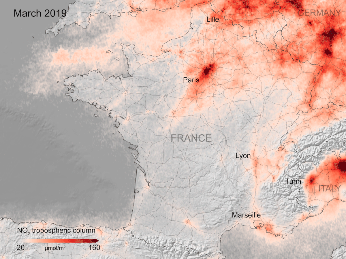
New data, based on observations from the Copernicus Sentinel-5P satellite, are showing strong reductions in nitrogen dioxide concentrations over several major cities across Europe – including Paris, Madrid and Rome.
Rice fields, Vietnam
27.3.2020 10:00 ESA Observing the Earth Image:
The Copernicus Sentinel-1 mission takes us over part of the Mekong Delta – a major rice-producing region in southwest Vietnam.
Image:
The Copernicus Sentinel-1 mission takes us over part of the Mekong Delta – a major rice-producing region in southwest Vietnam.
Earth from Space: Rice fields, Vietnam
27.3.2020 10:00 ESA Observing the Earth Video:
00:03:05
Video:
00:03:05
In this week's edition of the Earth from Space programme, the Copernicus Sentinel-1 mission takes us over part of the Mekong Delta – a major rice-producing region in southwest Vietnam.
See also Rice fields, Vietnam to download the image.
Vizualizace koronaviru na glóbu
27.3.2020 8:58 GISportal.cz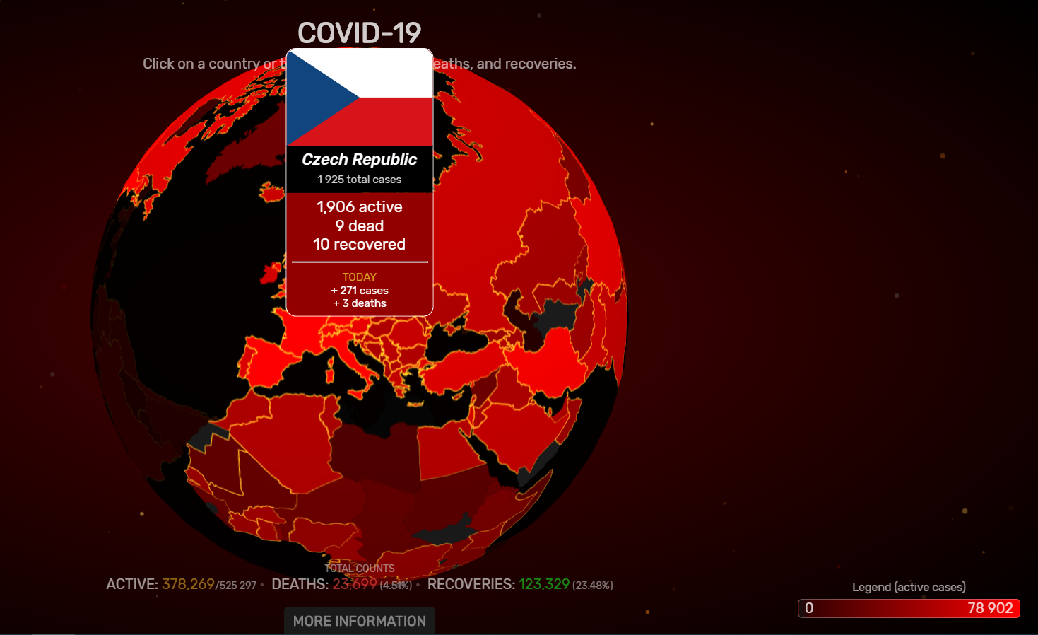
Každý den se objevuje mnoho nových, více či méně, povedených vizualizací počtů či míry nakažení koronavirem (COVID-19). Další zajímavou vizualizací, je použití rotujícího glóbu v projektu www.covidvisualizer.com. Webovou prezentaci vytvořili dva studenti z Carnegie Mellon University (Navid Mamoon a Gabriel Rasskin). Data jsou pravidelně stahována z Worldometer.
The post Vizualizace koronaviru na glóbu appeared first on GISportal.cz.
Hlídač státu sleduje stav mostů v ČR
27.3.2020 8:11 GeoBusinessHlídač státu, na němž naleznete například přehled veřejných zakázek včetně dokumentace a vysoutěžené ceny, má také celou řadu dalších funkcí a databází, které nejsou na první pohled viditelné. Jednou ze specializovaných databází je Stav mostů v ČR, která sleduje stav mostů na dálnicích a silnicích 1. třídy ve správě Ředitelství silnic a dálnic ČR. Databáze […]
The post Hlídač státu sleduje stav mostů v ČR appeared first on GeoBusiness.
Aplikace mapuje data o pohybu obyvatel v Praze (TZ)
27.3.2020 8:06 GISportal.cz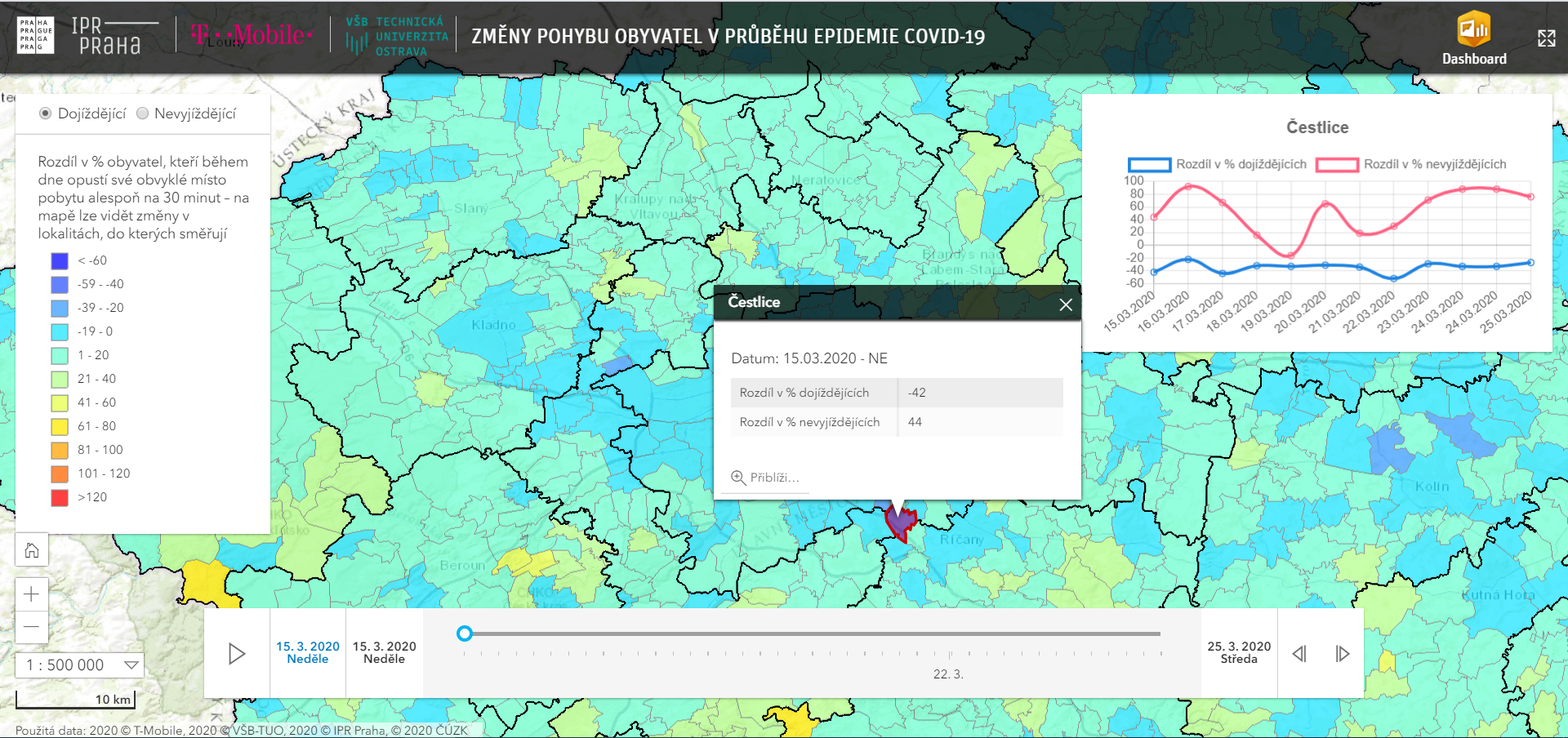
V okolí domova kvůli nařízení vlády zůstává o 80 % Pražanů více než obvykle, část se jich přesunula do rekreačních oblastí. Aplikace mapuje data o pohybu obyvatel Díky nařízení vlády o omezení pohybu zůstává ve všední den doma až 34 % lidí z celé České republiky a do práce jich nejde téměř polovina. Institut plánování a rozvoje […]
The post Aplikace mapuje data o pohybu obyvatel v Praze (TZ) appeared first on GISportal.cz.
Textron to Release First Quarter Results on April 22, 2020
27.3.2020 8:00 GISCafe.com Webcasts-Webinars PROVIDENCE, R.I. — (BUSINESS WIRE) — March 23, 2020 — Textron Inc. (NYSE: TXT) will release its first quarter 2020 financial …INSPIRE téma Rozšířené Parcely (CPX)
27.3.2020 1:00 Cenia - Katalog metadat ČR - INSPIRE Rozšíření má za cíl poskytovat katastrální mapu s obsahem podle vyhlášky ve vektorové podobě ve struktuře plně v souladu se strukturou danou směrnicí INSPIRE. Data rozšiřují směrnici INSPIRE pro téma katastrální parcely (CP) o věcná břemena, geodetické body, další prvky mapy, původní obloukovou geometrii a o parcely určené definičním bodem (ty pouze v oblastech s analogovou mapou). Vychází z katastrální mapy, která je závazným státním mapovým dílem velkého měřítka, obsahuje body polohového bodového pole, polohopis a popis a může mít formu digitální mapy, analogové mapy nebo digitalizované mapy. Publikovaná data obsahují katastrální území pro celou Českou Republiku, parcely a jejich hranice, věcná břemena, další prvky mapy a původní obloukovou geometrii z území, kde je digitální mapa (k 23. 03. 2020 je to 96,70% území České republiky, t.j. 76 265,63km2) a ve zbytku území katastrální parcely určené pouze definičním bodem (tedy bez hranic a polygonu). Katastrální parcely a hranice obsahují oproti datové sadě INSPIRE některé atributy navíc. Jedná se o typ hranice, způsob využití území, druh pozemku, vazbu na budovu a o mapové značky. Více katastrální zákon 344/1992 SB., katastrální vyhláška č.26/2007 Sb. v platném znění a INSPIRE Data Specification on Cadastral Parcels v 3.0.1. Data ve formátu GML 3.2.1 jsou validní proti schématu XML pro Rozšířené Parcely (CPX) ve verzi 4.0.INSPIRE téma Budovy (BU)
27.3.2020 1:00 Cenia - Katalog metadat ČR - INSPIRE Data odpovídají směrnici INSPIRE pro téma budovy (BU). Data pochází částečně z projektu RÚIAN (Registr územní identifikace, adres a nemovitostí), který je součástí základních registrů České Republiky a obsahuje informace o územní identifikaci, adresách a nemovitostech, a částečně z ISKN (Informační systém katastru nemovistostí). Zdrojem informací o budovách v ISKN je objekt Stavba, v RÚIAN je to Stavební objekt. Většina Staveb je zároveň Stavebními objekty, ale jsou případy, kdy tomu tak není. Kromě Budov datová sada obsahuje i části budov, které jsou pro potřeby INSPIRE vyjádřeny vchody z RÚIAN. Vchody obsahují informace o počtu podlaží, technickoekonomických atributech apod. Datová sada pokrývá celé území české republiky. V datové sadě není uvedeno 1,15%, t.j. 48455 budov (k 23. 03. 2020), protože neobsahují definiční bod ani polygon. Více v zákoně č. 111/2009 Sb., o základních registrech, ve vyhlášce č. 359/2011 Sb., o základním registru územní identifikace, adres a nemovitostí v platných zněních, v zákoně 256/2013 Sb., o katastru nemovitostí, v katastrální vyhlášce č. 357/2013 Sb. v platném znění a INSPIRE Data Specification on Buildings v 3.0 z 13.12.2013. Data ve formátu GML 3.2.1 jsou validní proti schématu XML pro INSPIRE téma Budovy ve verzi 4.0 a proti schématu pro prostorová data ELF ve verzi 1.0.INSPIRE téma Adresy (AD)
27.3.2020 1:00 Cenia - Katalog metadat ČR - INSPIRE Data odpovídají směrnici INSPIRE pro téma adresy (AD). Vychází především z projektu RÚIAN (Registr územní identifikace, adres a nemovitostí), který je součástí základních registrů České Republiky a obsahuje informace o územní identifikaci, adresách a nemovitostech. Data publikovaná v rámci INSPIRE obsahují pouze adresní místa a jejich komponenty, kterými jsou stát, obec, část obce, městský obvod v Praze (MOP), městký obvod/městská část (MO/MČ), ulice a pošta a to na území celé České Republiky. Obsahují rozvněž geometrii, která určuje definiční bod adresního místa. V datové sadě nění uvedeno 1,19%, t.j. 34895 adresních míst (k 23. 03. 2020), protože neobsahují definiční bod, podle kterého by je bylo možné prostorově určit. Více v zákoně č. 111/2009 Sb., o základních registrech a ve vyhlášce č. 359/2011 Sb., o základním registru územní identifikace, adres a nemovitostí v platných zněních a INSPIRE Data Specification on Addresses v 3.0.1 z 26.4.2010. Data ve formátu GML 3.2.1 jsou validní proti schématu XML pro INSPIRE téma Adresy ve verzi 4.0 a proti schématu pro prostorová data ELF ve verzi 1.0.INSPIRE téma Parcely (CP)
27.3.2020 1:00 Cenia - Katalog metadat ČR - INSPIRE Data odpovídají směrnici INSPIRE pro téma katastrální parcely (CP). Vychází z katastrální mapy, která je závazným státním mapovým dílem velkého měřítka, obsahuje body polohového bodového pole, polohopis a popis a může mít formu digitální mapy, analogové mapy nebo digitalizované mapy. Data publikovaná v rámci INSPIRE obsahují pouze katastrální území (pro celou Českou Republiku) a parcely a jejich hranice z území, kde je digitální mapa (k 23. 03. 2020 je to 96,70% území České republiky, t.j. 76 265,63km2). Více katastrální zákon 344/1992 SB., katastrální vyhláška č.26/2007 Sb. v platném znění a INSPIRE Data Specification on Cadastral Parcels v 3.0.1. Data ve formátu GML 3.2.1 jsou validní proti schématu XML pro INSPIRE téma Parcely ve verzi 4.0 a proti schématu pro prostorová data ELF ve verzi 1.0.State Governments Using Vexcel Imagery to Aid in COVID-19 Response
26.3.2020 23:29 GISCafe.com Webcasts-Webinars The worldwide COVID-19 pandemic has now reached all 50 states in the U.S. In accordance with Federal Government and Center for Disease Control and …OGC and Ordnance Survey Invite Developers to the OGC API - Tiles Sprint
26.3.2020 21:05 GISCafe.com Webcasts-Webinars Online code sprint will further develop and test a new OpenAPI-based OGC API for the delivery of tiled resources, such as raster or vector …Draganfly Selected to Globally Integrate Breakthrough Health Diagnosis Technology Immediately onto Autonomous Camera’s and Specialized Drones to Combat Coronavirus (COVID-19) and Future Health Emergencies
26.3.2020 20:00 GISCafe.com Webcasts-Webinars Partnering with The University of South Australia developers of the technology in collaboration with the Australian Department of Defence – Defence …ICEYE Unveils 25 cm SAR Imaging Capability with Current SAR Satellite Constellation
26.3.2020 20:00 GISCafe.com Webcasts-Webinars With an in-orbit demonstration from ICEYE radar imaging satellites, the company's data achieves the finest resolution class in commercial SAR. The …Skyfire Consulting to Deliver High-End American-Made Drones for Critical Sectors with Majority Stake Acquisition of Viking UAS
26.3.2020 20:00 GISCafe.com Webcasts-Webinars ATLANTA, March 26, 2020 — (PRNewswire) — Skyfire Consulting (skyfireconsulting.com), the most trusted and experienced public safety UAS …Airbus successfully completes In Orbit Commissioning of CHEOPS
26.3.2020 18:50 GISCafe.com Webcasts-Webinars Airbus meets all expectations and the spacecraft is delivered in orbit@AirbusSpace @ESA @ESA_CHEOPS #Cheops #exoplanets
Madrid, 26 March 2020 …
Microsoft builds digital twin for Singapore headquarters
26.3.2020 16:50 Bentley SystemsPress Coverage
Business Chief Asia, UK
Read the articleTopcon Defines What Intelligent Construction Products and Workflows Look Like at CONEXPO 2020
26.3.2020 16:45 Bentley SystemsPress Coverage
Spar3D, USA
Read the articleBentley Systems Announces the Acquisition of GroupBC, UK Leader in Cloud Services for Construction Information Management
26.3.2020 16:40 Bentley SystemsPress Coverage
Global Banking & Finance Review, UK
Read the articleBentley buys GroupBC
26.3.2020 16:36 Bentley SystemsPress Coverage
Extranet Evolution, UK
Read the articleRevolutionizing Asset Management in The Water/Wastewater Industry
26.3.2020 16:33 Bentley SystemsPress Coverage
Water Online, USA
Read the articleInformace k posuzování běhu lhůt v oblasti veřejné správy v době trvání nouzového stavu
26.3.2020 15:22 ČÚZK /Urady/Katastralni-urady/Katastralni-urady/Katastralni-urad-pro-Zlinsky-kraj/O-uradu/Aktuality/Informace-k-posuzovani-behu-lhut-v-oblasti-verejneInformace k posuzování běhu lhůt v oblasti veřejné správy v době trvání nouzového stavu
26.3.2020 15:22 ČÚZK - předpisy a opatření Katastrální úřad pro Zlínský kraj zveřejnil novou aktualitu:Rada/odborný rada – rozhodování o povolení vkladu – RPV1003, zástup za MD/RD
26.3.2020 13:22 ČÚZK - volná místa Katastrální úřad pro Plzeňský kraj - Katastrální pracoviště Plzeň-město vypisuje výběrové řízení na místo Rada/odborný rada – rozhodování o povolení vkladu – RPV1003, zástup za MD/RDRada/odborný rada – rozhodování o povolení vkladu – RPV1003, zástup za MD/RD
26.3.2020 13:22 ČÚZK /Urady/Katastralni-urady/Katastralni-urady/Katastralni-urad-pro-Plzensky-kraj/Uredni-deska/Oznameni-a-jina-uredni-sdeleni/Volna-mista/Rada-odborny-rada-–-rozhodovani-o-povoleni-vkladuRada/odborný rada – rozhodování o povolení vkladu – RPV1003, zástup za MD/RD
26.3.2020 13:22 ČÚZK - předpisy a opatření Katastrální úřad pro Plzeňský kraj - Katastrální pracoviště Plzeň-městoobsazuje služební místo
Rada/odborný rada – rozhodování o povolení vkladu – RPV1003, zástup za MD/RD
PM - zástup za MD-RD - Rada/odborný rada – rozhodování o povolení vkladu – RPV1003
26.3.2020 13:19 ČÚZK - předpisy a opatření Katastrální úřad pro Plzeňský kraj, Katastrální pracoviště Plzeň-městovypisuje výběrové řízení na místo
PM - zástup za MD-RD - Rada/odborný rada – rozhodování o povolení vkladu – RPV1003
PM - zástup za MD-RD - Rada/odborný rada – rozhodování o povolení vkladu – RPV1003
26.3.2020 13:19 ČÚZK /PM-zastup-za-MD-RD-Rada-odborny-rada-–-rozhodoPM - zástup za MD-RD - Rada/odborný rada – rozhodování o povolení vkladu – RPV1003
26.3.2020 13:19 ČÚZK - volná místa Katastrální úřad pro Plzeňský kraj, Katastrální pracoviště Plzeň-město vypisuje výběrové řízení na místo PM - zástup za MD-RD - Rada/odborný rada – rozhodování o povolení vkladu – RPV1003Mobilní aplikace GeoGIS pro sběr dat v terénu
26.3.2020 9:36 GeoBusinessSpolečnost Geoobchod vytvořila GeoGIS, profesionální aplikaci pro sběr a úpravu dat přímo v terénu. Aplikace míří směrem do zemědělství, ekologie nebo do oborů, ve kterých je potřeba rychle shromažďovat geodata bez nutnosti opakovaně zadávat stejné informace. Přesnost Aplikaci lze instalovat na kterékoliv zařízení se systémem Android. Geoobchod jako prodejce GNSS technologií nabízí také ruční GNSS přístroje, […]
The post Mobilní aplikace GeoGIS pro sběr dat v terénu appeared first on GeoBusiness.
Aktuality pracoviště
26.3.2020 9:00 ČÚZK - předpisy a opatření Český úřad zeměměřický a katastrální zveřejnil novou aktualitu: V souladu s usnesením vlády č. 217 ze dne 15. března 2020 jsou úřední hodiny pro veřejnost pouze v pondělí a středu od 8,00 do 11,00 hod., v tyto úřední hodiny lze rovněž vhodit podání v zalepené obálce do uzavřené schránky, která je umístěna v přízemí budovy katastrálního pracoviště.Schránka je zpřístupněna v neúředních dnech od 6,00 do 8,00 hod a v úředních dnech od 6,00 do 11,00 hod
Pokud bude v podání uvedena e-mailová adresa, bude na ni zasláno potvrzení o přijetí podání. V případě, že je s podáním spojena poplatková povinnost, bude účastníkům zaslána i výzva k úhradě správního poplatku převodem na účet. Děkujeme, že budete v co největší míře využívat této zcela bezkontaktní možnosti.
Aktuality pracoviště
26.3.2020 9:00 ČÚZK - předpisy a opatření Katastrální úřad pro Vysočinu - Katastrální pracoviště Velké Meziříčí zveřejnil novou aktualitu:Důležité upozornění!
S účinností od 4. května 2020 dochází k obnovení standardního rozvrhu úředních hodin, tj. na pondělí a středu od 8:00 do 17:00 hodin, úterý, čtvrtek a pátek od 8:00 do 14:00 hodin.
I nadále upřednostňujeme bezkontaktní způsob podání (poštou, elektronicky či bezkontaktní schránkou u vchodu úřadu).
Při osobním kontaktu Vás žádáme o dodržování hygienických zásad a respektování pokynů našich zaměstnanců.
Děkujeme za pochopení.
Aktuality pracoviště
26.3.2020 9:00 ČÚZK /Urady/Katastralni-urady/Katastralni-urady/Katastralni-urad-pro-Vysocinu/Katastralni-pracoviste/KP-Velke-Mezirici/O-uradu/Aktuality/Aktuality-pracovisteAktuality pracoviště
26.3.2020 9:00 ČÚZK - předpisy a opatření Český úřad zeměměřický a katastrální zveřejnil novou aktualitu: V souladu s usnesením vlády č. 217 ze dne 15. března 2020 jsou úřední hodiny pro veřejnost pouze v pondělí a středu od 8,00 do 11,00 hod., v tyto úřední hodiny lze rovněž vhodit podání v zalepené obálce do uzavřené schránky, která je umístěna v přízemí budovy katastrálního pracoviště.Schránka je zpřístupněna v neúředních dnech od 6,00 do 8,00 hod a v úředních dnech od 6,00 do 11,00 hod
Pokud bude v podání uvedena e-mailová adresa, bude na ni zasláno potvrzení o přijetí podání. V případě, že je s podáním spojena poplatková povinnost, bude účastníkům zaslána i výzva k úhradě správního poplatku převodem na účet. Děkujeme, že budete v co největší míře využívat této zcela bezkontaktní možnosti.
Aktuality pracoviště
26.3.2020 9:00 ČÚZK - předpisy a opatření Katastrální úřad pro Vysočinu - Katastrální pracoviště Velké Meziříčí zveřejnil novou aktualitu: V souladu s usnesením vlády č. 217 ze dne 15. března 2020 jsou úřední hodiny pro veřejnost pouze v pondělí a středu od 8,00 do 11,00 hod., v tyto úřední hodiny lze rovněž vhodit podání v zalepené obálce do uzavřené schránky, která je umístěna v přízemí budovy katastrálního pracoviště.Schránka je zpřístupněna v neúředních dnech od 6,00 do 8,00 hod a v úředních dnech od 6,00 do 11,00 hod
Pokud bude v podání uvedena e-mailová adresa, bude na ni zasláno potvrzení o přijetí podání. V případě, že je s podáním spojena poplatková povinnost, bude účastníkům zaslána i výzva k úhradě správního poplatku převodem na účet. Děkujeme, že budete v co největší míře využívat této zcela bezkontaktní možnosti.
Aktuality pracoviště
26.3.2020 9:00 ČÚZK - předpisy a opatření Katastrální úřad pro Vysočinu - Katastrální pracoviště Velké Meziříčí zveřejnil novou aktualitu:Důležité upozornění!
S účinností od 4. května 2020 dochází k obnovení standardního rozvrhu úředních hodin, tj. na pondělí a středu od 8:00 do 17:00 hodin, úterý, čtvrtek a pátek od 8:00 do 14:00 hodin.
I nadále upřednostňujeme bezkontaktní způsob podání (poštou, elektronicky).
Při osobním kontaktu Vás žádáme o dodržování hygienických zásad a respektování pokynů našich zaměstnanců.
Děkujeme za pochopení.
Mapa #stayhome #staysafe zobrazuje pravděpodobnost sociálního kontaktu v době koronaviru
26.3.2020 8:59 GISportal.cz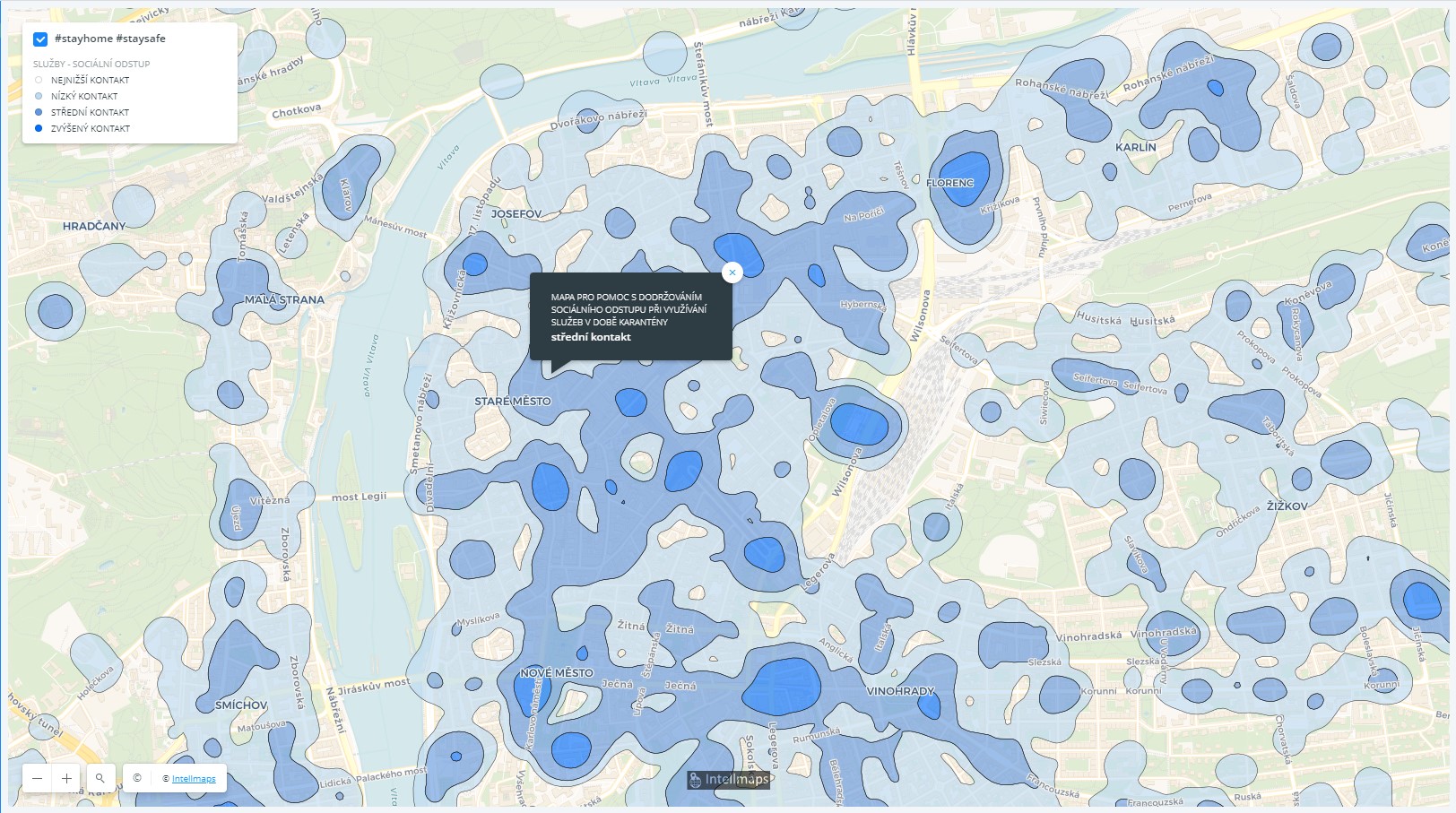
Mapa pro pomoc s dodržováním sociálního odstupu při využívání služeb v době karantény je vytvořena na základě služeb občanům, které jsou v období karantény v úplném, či částečném provozu, jako jsou např.: prodejny potravin, drogerie, pet food (zverimexy) a další, stanice MHD, banky, bankomaty, zdravotnická zařízení a celá řada dalších služeb. Mapa je dostupná pro […]
The post Mapa #stayhome #staysafe zobrazuje pravděpodobnost sociálního kontaktu v době koronaviru appeared first on GISportal.cz.
Zrušení členské schůzce CAGI
26.3.2020 8:44 GISportal.cz
Předsednictvo CAGI 19. 3. 2020 rozhodlo o zrušení členské schůze 1. 4. 2020. Náhradní termín členské schůze prozatím nebyl určený, teoreticky padly dva návrhy – druhá polovina června 2020, nebo září 2020. Plánovaný seminář k DTM se uskuteční virtuálně, je tak stále možné se na něj registrovat. Registrovaní účastníci následně obdrží podrobnější informace o tom, jak se připojit […]
The post Zrušení členské schůzce CAGI appeared first on GISportal.cz.
Schránka na podání
26.3.2020 6:15 ČÚZK - předpisy a opatření Katastrální úřad pro Liberecký kraj - Katastrální pracoviště Jablonec nad Nisou zveřejnil novou aktualitu:Vážení klienti !
Přestože jsou v souladu s usnesením vlády č. 217 ze dne 15. března 2020 úřední hodiny pro veřejnost pouze v pondělí a středu od 8,00 do 11,00 hod., je možné i mimo tyto úřední hodiny vhodit podání v zalepené obálce do uzavřené schránky. Ve vestibulu budovy Katastrálního úřadu pro Liberecký kraj, Katastrálního pracoviště Jablonec nad Nisou (dále jen úřad) je z tohoto důvodu umístěna schránka pro příjem podání sloužit. V zalepené obálce lze vhazovat podání (návrhy na zápis práv a jiných údajů do katastru), a to i mimo v nouzovém režimu stanovené úřední hodiny. Tato schránka je k dispozici v pracovní dny od 7:00 do 14: 00 hod a vybírá se v 10:00 a v 14:00 hod. Obálky jsou k dispozici v krabici umístěné na schránce.
Potvrzení o přijetí podání obdržíte na e-mail, který prosím uvádějte v návrhu (podání). Na tento e-mail Vám bude rovněž zaslán podklad pro platbu (v případě, že je podání návrhu zpoplatněno) tak, abyste mohli provést platbu bezhotovostně prostřednictvím Vaší banky.
Pokud potřebujete vyplnit návrh na vklad, případně jiný formulář, doporučujeme Vám jej vyplnit z domova v elektronické aplikaci na adrese: https://www.cuzk.cz/Fornulare-a-elektronicka-podani resp. na adrese: https://nv.cuzk.cz/Web/Uvod.aspx.
Děkujeme, že budete v co největší míře využívat této zcela bezkontaktní možnosti, zároveň Vás prosíme, nevhazujte v obálce hotovost, platbu zaplaťte bezhotovostně na výzvu resp. podklad pro platbu, který Vám bude zaslán na e-mail!
Natura 2000 - Ptačí oblasti
26.3.2020 1:00 Cenia - Katalog metadat ČR - INSPIRE Hranice ptačích oblastí vymezených v rámci soustavy Natura 2000 a určených k ochraně ptačích druhů dle platných nařízení vlády, kterými se vymezují ptačí oblasti, a dle směrnice 2009/147/ES o ochraně volně žijících ptáků; vrstva obsahuje složené prvky (Multipart Features); © AOPK ČR, 2017Natura 2000 - Evropsky významné lokality
26.3.2020 1:00 Cenia - Katalog metadat ČR - INSPIRE Hranice evropsky významných lokalit vymezených v rámci soustavy Natura 2000 a určených k ochraně přírodních stanovišť a nebo populací druhů dle platného nařízení vlády, kterým se stanoví národní seznam evropsky významných lokalit, a dle směrnice 92/43/EHS o ochraně přírodních stanovišť, volně žijících živočichů a planě rostoucích rostlin; vrstva obsahuje složené prvky (Multipart Features); © AOPK ČR, 2020INSPIRE Protected sites - Natura 2000
26.3.2020 1:00 Cenia - Katalog metadat ČR - INSPIRE This data set contains spatial data for Natura 2000 sites in the Czech Republic. It includes proposed Sites of Community Importance, Sites of Community Importance and Special Areas of Conservation according to the EC Directive on the conservation of natural habitats and of wild fauna and flora (92/43/EEC) as well as proposed Special Protection Areas and Special Protection Areas according to the EC Directive on the conservation of wild birds (79/409/EEC). Not all categories must be filled at a specific time.VZ: Vytyčení a stabilizace lomových bodů hranic pozemků po PÚ
26.3.2020 0:41 ZeměměřičStátní pozemkový úřad vypsal veřejnou zakázku malého rozsahu na služby. Jejím předmětem je vytyčení a stabilizace lomových bodů hranic pozemků po provedených pozemkových úpravách v okresech Jeseník, Olomouc, Prostějov, Přerov a Šumperk. Úřední název: Státní pozemkový úřad Název oddělení: KPÚ pro Olomoucký kraj Postup: VZMR s uveřejněním výzvy Režim veřejné zakázky: VZ malého rozsahu Předpokládaná hodnota: 480 000 Kč bez DPH Datum […]
The post VZ: Vytyčení a stabilizace lomových bodů hranic pozemků po PÚ appeared first on Zeměměřič.
Dvě místa na výzkumný pobyt ve Vídni
26.3.2020 0:00 Geografický ústav MUNa tento kalendářní rok jsou ještě 2 volná místa pro mladé vědce a doktorandy na výzkumný měsíční pobyt na partnerské univerzitě ve Vídni (https://czs.muni.cz/cs/pracovnik-mu/ostatni-pobyty/program-vztahu-s-tradicnimi-univerzitami).
Kompletní přihlášky zájemců včetně příloh je možno dodat (nejlépe elektronicky/nasdílet na one drive) do 26. března.
Dvě místa na výzkumný pobyt ve Vídni
26.3.2020 0:00 Geografický ústav MUNa tento kalendářní rok jsou ještě 2 volná místa pro mladé vědce a doktorandy na výzkumný měsíční pobyt na partnerské univerzitě ve Vídni. https://czs.muni.cz/cs/pracovnik-mu/ostatni-pobyty/program-vztahu-s-tradicnimi-univerzitami
Kompletní přihlášky zájemců včetně příloh je možno dodat (nejlépe elektronicky/nasdílet na one drive) do 26. března.
Zeměměřické činnosti v době nouzového stavu
25.3.2020 21:22 Asociace podnikatelů v geomatice Zde naleznete vyjádření ČÚZK k žádosti Ing. Martina Hrdličky, předsedy APG o udělení výjimky při provádění zeměměřických činností v době nouzového stavu.Woolpert Senior Vice President Jeff Lovin Named President of ASPRS
25.3.2020 18:59 GISCafe.com Webcasts-Webinars The Certified Photogrammetrist and Professional Surveyor was inducted today during the geospatial organization's online event.DAYTON, Ohio, March …
Hexagon ukázal nový Luciad 2020
25.3.2020 17:25 GeoBusinessFirma Hexagon představila novou verzi své softwarové platformy Luciad. Novinkou v Luciad 2020 je především LuciadCPillar, aplikační programátorské rozhraní API pro vývojáře v jazycích C++ a C#. Díky API se tedy pokročilé geoprostorové analýzy a vizualizace mohou integrovat do aplikací třetích stran. Serverová část LuciadFusion je poháněna novým enginem pro 3D dlaždice, které se dají […]
The post Hexagon ukázal nový Luciad 2020 appeared first on GeoBusiness.
Doosan Mobility Innovation Demonstrated Power of Hydrogen Fuel Cell Drone During African Drone Forum
25.3.2020 16:23 GISCafe.com Webcasts-Webinars KIGALI, Rwanda — (BUSINESS WIRE) — March 24, 2020 —Doosan Mobility Innovation (DMI) participated in the African Drone Forum …
GPS Data Shows Critical Truck Deliveries Continue Despite COVID-19
25.3.2020 16:23 GISCafe.com Webcasts-Webinars Analysis of Data Finds Unprecedented Performance Year-Over-YearATLANTA, March 24, 2020 — (PRNewswire) — Today, the American …
Industrial Growth via M&A, Collaborations, and Digital Twins
25.3.2020 16:07 Bentley SystemsPress Coverage
ARC Advisory Group, USA
Read the articleARC's Jim Frazer Interviews Bentley Systems’ Bob Mankowski
25.3.2020 16:03 Bentley SystemsPress Coverage
ARC Advisory Group, USA
Read the articleDigitally transforming the digital transformers
25.3.2020 15:51 Bentley SystemsPress Coverage
Civil Engineering Surveyor, USA
Read the articleDeveloping the digital construction workforce: A Q&A with Greg Bentley
25.3.2020 15:43 Bentley SystemsPress Coverage
McKinsey, USA
Read the articleInformace o možnosti bezkontaktního podání
25.3.2020 15:40 ČÚZK /Urady/Katastralni-urady/Katastralni-urady/Katastralni-urad-pro-Stredocesky-kraj/Katastralni-pracoviste/KP-Slany/O-uradu/Aktuality/UpozorneniInformace o možnosti bezkontaktního podání
25.3.2020 15:40 ČÚZK - předpisy a opatření Katastrální úřad pro Středočeský kraj - Katastrální pracoviště Slaný zveřejnil novou aktualitu: UpozorněníPodání můžete učinit bezkontaktně do schránky umístěné u vchodu do budovy.
Lze tak podat i návrh na vklad v zalepené obálce.
V podání uveďte Váš e-mail, budeme Vás informovat o přijetí a případně Vás vyzveme k zaplacení poplatku převodem na účet.
Pokud budete podávat více podání, označte jejich pořadí.
Dále upozorňujeme na možnost elektronického podání s využitím datové schránky. Taková podání musí být převedena z analogové do elektronické podoby s využitím autorizované konverze dokumentu, opatřena značkou subjektu nebo elektronickým podpisem osoby, která konverzi provedla, a výstup opatřen kvalifikovaným časovým razítkem a musí být zaslán prostřednictvím datové schránky účastníka řízení nebo jeho zástupce (vše na www.cuzk.cz).
Schránka je přístupna z ulice, nepřetržitě.
Informace o možnosti bezkontaktního podání
25.3.2020 15:40 ČÚZK - předpisy a opatření Katastrální úřad pro Středočeský kraj - Katastrální pracoviště Slaný zveřejnil novou aktualitu: Upozornění Informace o možnosti bezkontaktního podání - sběrný boxPodání můžete učinit bezkontaktně do schránky umístěné u vchodu do budovy.
Lze tak podat i návrh na vklad v zalepené obálce.
V podání uveďte Váš e-mail, budeme Vás informovat o přijetí a případně Vás vyzveme k zaplacení poplatku převodem na účet.
Pokud budete podávat více podání, označte jejich pořadí.
Dále upozorňujeme na možnost elektronického podání s využitím datové schránky. Taková podání musí být převedena z analogové do elektronické podoby s využitím autorizované konverze dokumentu, opatřena značkou subjektu nebo elektronickým podpisem osoby, která konverzi provedla, a výstup opatřen kvalifikovaným časovým razítkem a musí být zaslán prostřednictvím datové schránky účastníka řízení nebo jeho zástupce (vše na www.cuzk.cz).
Schránka je nepřetržitě přístupna z ulice a bude kontorolována několikrát denně Pondělí - Pátek od 7:00 - 13:00 hod.
Informace o možnosti bezkontaktního podání
25.3.2020 15:40 ČÚZK - předpisy a opatření Katastrální úřad pro Středočeský kraj - Katastrální pracoviště Slaný zveřejnil novou aktualitu: Upozornění Informace o možnosti bezkontaktního podáníPodání můžete učinit bezkontaktně do schránky umístěné u vchodu do budovy.
Lze tak podat i návrh na vklad v zalepené obálce.
V podání uveďte Váš e-mail, budeme Vás informovat o přijetí a případně Vás vyzveme k zaplacení poplatku převodem na účet.
Pokud budete podávat více podání, označte jejich pořadí.
Dále upozorňujeme na možnost elektronického podání s využitím datové schránky. Taková podání musí být převedena z analogové do elektronické podoby s využitím autorizované konverze dokumentu, opatřena značkou subjektu nebo elektronickým podpisem osoby, která konverzi provedla, a výstup opatřen kvalifikovaným časovým razítkem a musí být zaslán prostřednictvím datové schránky účastníka řízení nebo jeho zástupce (vše na www.cuzk.cz).
Schránka je nepřetržitě přístupna z ulice a bude kontorolována několikrát denně Pondělí - Pátek od 7:00 - 13:00 hod.
Upozornění
25.3.2020 15:40 ČÚZK - předpisy a opatření Katastrální úřad pro Středočeský kraj - Katastrální pracoviště Slaný zveřejnil novou aktualitu: UpozorněníPodání můžete učinit bezkontaktně do schránky umístěné u vchodu do budovy.
Lze tak podat i návrh na vklad v zalepené obálce.
V podání uveďte Váš e-mail, budeme Vás informovat o přijetí a případně Vás vyzveme k zaplacení poplatku převodem na účet.
Pokud budete podávat více podání, označte jejich pořadí.
Dále upozorňujeme na možnost elektronického podání s využitím datové schránky. Taková podání musí být převedena z analogové do elektronické podoby s využitím autorizované konverze dokumentu, opatřena značkou subjektu nebo elektronickým podpisem osoby, která konverzi provedla, a výstup opatřen kvalifikovaným časovým razítkem a musí být zaslán prostřednictvím datové schránky účastníka řízení nebo jeho zástupce (vše na www.cuzk.cz)
How going digital can reverse your engineering challenges
25.3.2020 15:39 Bentley SystemsPress Coverage
Electronic Specifier, UK
Read the articleKorona Coxombs, aneb Kenneth Field mapuje
25.3.2020 15:26 GISportal.cz
Kenneth Field, autor kartografického best-selleru Cartography a vítěz mnoha kartografických/designových soutěží a cen se také pustil do mapování koronaviru. Představil vlastní mapovou aplikaci s velmi zajímavou vizualizací. Pro zobrazení výsledků použil “coxcomb” grafy, což je v překladu nejblíže polárnímu diagramu, jen s tím rozdílem, že zde se nejedná o cyklický jev. Data, podobně jako většina jiných, […]
The post Korona Coxombs, aneb Kenneth Field mapuje appeared first on GISportal.cz.
Deset let služby UtilityReport a novinky v roce 2020
25.3.2020 14:45 GeoBusinessSlužba UtilityReport, která pomáhá hromadně žádat správce sítí o jejich vyjádření v rámci procesu stavebního řízení, oslavila v roce 2019 deset let na trhu. Společnost Hrdlička po kompletním upgradu aplikace v roce 2018 investovala i nadále v roce 2019 do rozvoje služby. Přinášíme tedy ohlédnutí za rokem 2019 v rozvoji UtilityReportu a zároveň přehled novinek […]
The post Deset let služby UtilityReport a novinky v roce 2020 appeared first on GeoBusiness.
Získali jsme podporu k inovacím v DOPRAVĚ 2020+
25.3.2020 14:30 CEDA Maps a.s. Milujeme objevování nového! Jsme rádi, když můžeme naše zkušenosti využít pro lepší fungování světa kolem nás. O to víc nás těší úspěch tří projektů ve veřejné soutěži Doprava 2020+. Ve spolupráci se špičkovými odborníky ze soukromých firem i univerzit a za podpory Technologické agentury ČR budeme hledat cesty ke zlepšení dopravy ve městech a zefektivnění agendy dopravních staveb.ArcGIS zdarma pro všechny, co řeší situaci s Covid-19
25.3.2020 13:19 GeoBusinessSpolečnost Esri oznámila, že vzhledem k situaci kolem nového koronaviru COVID-19 nabízí svůj software zdarma pro všechny informační servery měst a obcí, krizové štáby a další instituce a organizace, které aktuální výzvu řeší. V případě, že se výše uvedenou nabídku rozhodnete využít, je český distributor Arcdata Praha připraven vám pomoci s nastavením všeho potřebného. Pište jim na adresu […]
The post ArcGIS zdarma pro všechny, co řeší situaci s Covid-19 appeared first on GeoBusiness.
GFI Archiver na archivaci e-mailů má přepracované uživatelské rozhraní
25.3.2020 13:07 GeoBusinessSpolečnost GFI Software představila GFI Archiver 15.0, nejnovější verzi svého řešení pro archivaci e-mailů a souborů, která obsahuje kompletně přepracované uživatelské rozhraní v responzivním webovém standardu HTML5, snazší a efektivnější vyhledávání archivovaných položek v desktopových i mobilních zařízeních, a vylepšené reportování. Novou verzi mohou okamžitě začít využívat jak zákazníci GFI Archiver, tak předplatitelé licenčního modelu […]
The post GFI Archiver na archivaci e-mailů má přepracované uživatelské rozhraní appeared first on GeoBusiness.
Další licence ArcGISu pro školy na půl roku zdarma
25.3.2020 13:00 GeoBusinessSpolečnost Arcdata Praha oznámila, že školám, kterým v aktuálním distančním výukovém režimu chybí licence, nabízí termínované licence softwarů ArcGIS Desktop a ArcGIS Online až do 31. srpna 2020 zcela zdarma. Jde o licence, určené zaměstancům a studentům vzdělávacích zařízení a využití licencí je omezeno na výukové a vědecké účely dle standardní licenční smlouvy (odstavec 2.6 […]
The post Další licence ArcGISu pro školy na půl roku zdarma appeared first on GeoBusiness.
Doplnění změn územně plánovacích dokumentací
25.3.2020 13:00 Plzeňský kraj Nově bylo uveřejněno dalších 33 změn územně plánovacích dokumentací. Vyhledat příslušnou územně plánovací dokumentaci můžete v sekci Územní plánování » Obce v kraji » Územní plány a další nástroje územního plánování. Nově jsou k dispozici následující změnové dokumentace: Změna č.1 ÚP Blížejov, Změna č.1 ÚP Čímice, Změna č.1 ÚP Díly, Změna č.1 ÚP Dražeň, Změna č.1 ÚP Hlavňovice, Změny č.1B a č.1C ÚP města Horažďovice, Změna č.2 ÚP Horní Bělá, Změna č.1 ÚP Hvozd, Změna č.2 ÚP Cheznovice, Změna č.1 ÚP Chlistov, Změny č.1 a č.3 ÚP Chodová Planá, Změna č.4 ÚP Chrást, Změna č.1 ÚP Chudenice, Změna č.4 ÚP obce Kařez, Změna č.1 ÚP Klatovy, Změna č.5 ÚP Kralovice, Změna č.1 ÚP Křenovy, Změna č.2 ÚP Líšťany, Změna č.1 ÚP Líté, Změna č.3 ÚP Měčín, Změna č.1 ÚP Mladotice, Změna č.1 ÚP Nalžovské Hory, Změna č.1 ÚP obce Nová Ves, Změna č.1 ÚP Obytce, Změna č.1 ÚP Planá, Změna č.2 ÚP Rybnice, Změna č.1 ÚP Stráž, Změna č.2 ÚP Stříbro, Změna č.3 ÚP Tachov, Změna č.1 ÚP Velečín, Změna č.1 ÚP Výrov, Změna č.1 RP Rokycany - lokalita Pod Čilinou.Zeměměřické činnosti pro katastr v době nouzového stavu
25.3.2020 12:09 ČÚZK - RSS kanál pro zeměměřičeZeměměřické činnosti pro katastr v době nouzového stavu
25.3.2020 12:09 ČÚZK - předpisy a opatření Český úřad zeměměřický a katastrální zveřejnil novou aktualitu: Zeměměřické činnosti pro katastr v době nouzového stavuZeměměřické činnosti pro katastr v době nouzového stavu
25.3.2020 12:09 ČÚZK - RSS kanál pro zeměměřiče Zeměměřické činnosti pro katastr v době nouzového stavuZeměměřické činnosti pro katastr v době nouzového stavu
25.3.2020 12:09 ČÚZK - předpisy a opatření Český úřad zeměměřický a katastrální zveřejnil novou aktualitu:Zeměměřické činnosti pro katastr v době nouzového stavu
25.3.2020 12:09 ČÚZK /Zememerictvi/Zememericke-cinnosti/Aktuality-pro-zememerice/2020/Zememericke-cinnosti-pro-katastr-v-dobe-nouzovehoZeměměřické činnosti pro katastr v době nouzového stavu
25.3.2020 12:09 ČÚZK - RSS kanál pro zeměměřiče Zeměměřické činnosti pro katastr v době nouzového stavu.Zeměměřické činnosti pro katastr v době nouzového stavu
25.3.2020 12:09 ČÚZK - předpisy a opatření Český úřad zeměměřický a katastrální zveřejnil novou aktualitu: Zeměměřické činnosti pro katastr v době nouzového stavu.Představujeme systém EMS18 od E.ON
25.3.2020 9:37 GeoBusinessZeptali jsme se Lukáše Opata z firmy Hrdlička, aby vysvětlil, k čemu se používá služba EMS18. Kdo musí službu EMS18 používat? A proč číslo osmnáct? EMS je zkratka pro „Externí mapová služba“ společnosti E.ON. Číslovka 18 znamená, že vývoj mapové služby začal v roce 2018. EMS18 musí využívat geodeti a projektanti pro předávání dat pořízených dokumentací. Ze služby […]
The post Představujeme systém EMS18 od E.ON appeared first on GeoBusiness.
ArcGIS do škol zdarma
25.3.2020 8:45 GISportal.cz
Společnost ARCDATA PRAHA nabízí školám, které v aktuálním výukovém režimu postrádají dostatek licencí ArcGIS, poskytnutí termínovaných licencí ArcGIS Desktop, ArcGIS Online až do 31. 8. 2020 zdarma. Jedná se o licence, které jsou určeny pro zaměstance a studenty vzdělávacích zařízení a jejich využití je omezeno na výukové a vědecké účely dle standardní licenční smlouvy (odstavec 2.6 b). […]
The post ArcGIS do škol zdarma appeared first on GISportal.cz.
Mapování COVID-19 na Slovensku
25.3.2020 8:21 GISportal.cz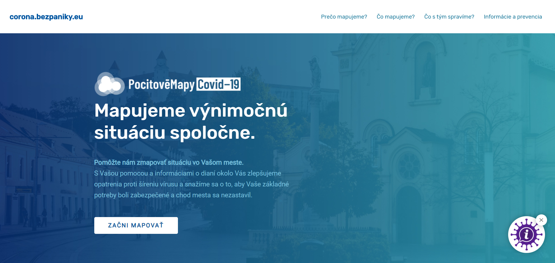
Projekt PocitoveMapy.sk vytvořil speciální mapu pro mapování šíření koronaviru na Slovensku – corona.bezpaniky.eu. Stránka je příjemně připravena pro použití na mobilních zařízeních. Práce na PC/laptopu již trochu postrádá lehkost, ale i tak se jedná o zdařilý projekt, který může pomoci v boji s koronavirem na Slovensku. V rámci mapování jsou respondenti tázáni na několik otázek, […]
The post Mapování COVID-19 na Slovensku appeared first on GISportal.cz.
20200325 - Zeměměřické činnosti pro katastr v době nouzového stavu
25.3.2020 8:15 ČÚZK /Aktuality-resort/2020/20200325-Zememericke-cinnosti-pro-katastr-v-dobe20200325 - Zeměměřické činnosti pro katastr v době nouzového stavu
25.3.2020 8:15 ČÚZK - předpisy a opatření Český úřad zeměměřický a katastrální zveřejnil novou aktualitu: Zeměměřické činnosti pro katastr v době nouzového stavuMemorandum o spolupráci s ČKA
25.3.2020 7:12 Asociace podnikatelů v geomatice V uplynulém období se uskutečnila celá řada jednání vedení APG a zástupců České komory architektů. Obě strany se dohodly na podepsání Memoranda o spolupráci, jehož cílem je především hledat společná témata, východiska, cíle a stanoviska a tato prosazovat v legislativě, a to především v oblasti investiční výstavby. Jedním z cílů bude také podpora technického vzdělávání v ČR. Obě strany se zavazují spolupracovat v oblastech územního […]APGEO - MEMORANDUM O SPOLUPRÁCI S ČKA
25.3.2020 1:00 Asociace podnikatelů v geomatice V uplynulém období se uskutečnila celá řada jednání vedení APG a zástupců České komory architektů.APGEO - ZEMĚMĚŘICKÉ ČINNOSTI V DOBĚ NOUZOVÉHO STAVU
25.3.2020 1:00 Asociace podnikatelů v geomatice Zde naleznete vyjádření ČÚZK k žádosti Ing. Martina Hrdličky, předsedy APG o udělení výjimky při provádění ...COVID-19: Mapping vulnerable populations in California
24.3.2020 19:54 GISCafe.com Webcasts-Webinars Publication
March 24, 2020
As part of the effort to respond to the needs of the most vulnerable and impacted …
TerraView Demonstrates Commitment to the Building of the American Drone Industry with Introduction of Second Commercial UAV Model
24.3.2020 19:27 GISCafe.com Webcasts-Webinars RangePro X8P, the follow-up to the RangePro X8, is proudly designed and manufactured in the USA, with U.S.-made flight control system (FCS) …GfK releases RegioGraph 2020
24.3.2020 18:54 GISCafe.com Webcasts-Webinars New version of geomarketing software now availableBruchsal, Germany, March 24, 2020 – GfK has released a new version of its geomarketing …
Analýza příjmů a výdajů a kontrola výkazů
24.3.2020 18:10 ČÚZK - volná místa Český úřad zeměměřický a katastrální vypisuje výběrové řízení na místo Analýza příjmů a výdajů a kontrola výkazůAnalýza příjmů a výdajů a kontrola výkazů
24.3.2020 18:10 ČÚZK - předpisy a opatření Český úřad zeměměřický a katastrálnívypisuje výběrové řízení na místo
Analýza příjmů a výdajů a kontrola výkazů
Analýza příjmů a výdajů a kontrola výkazů
24.3.2020 18:10 ČÚZK /Urady/Cesky-urad-zememericky-a-katastralni/Uredni-deska/Oznameni-a-jina-uredni-sdeleni/Volna-mista/DMS/Analyza-prijmu-a-vydaju-a-kontrola-vykazuPAR Technology Corporation Subsidiary -- PAR Government Systems Introduces Commercial Version of GV3.0® Geospatial Viewing Application
24.3.2020 16:53 GISCafe.com Webcasts-Webinars NEW HARTFORD, N.Y. — (BUSINESS WIRE) — March 24, 2020 —PAR Government Systems (“PAR Government”), a provider of geospatial …
Clinical AI Leader Jvion Launches COVID Community Vulnerability Map
24.3.2020 16:53 GISCafe.com Webcasts-Webinars ATLANTA, March 24, 2020 (GLOBE NEWSWIRE) -- Jvion, the leader in clinical AI, today announced the launch of its COVID Community Vulnerability Map. …NEARMAP NAMES JEFF ADAMS CHIEF REVENUE OFFICER TO LEAD FUTURE GROWTH
24.3.2020 16:53 GISCafe.com Webcasts-Webinars SALT LAKE CITY, March 24, 2020 (GLOBE NEWSWIRE) -- Leading aerial imagery company Nearmap announced today that it has named Jeff Adams as Chief …PCI Geomatics Announces New Leadership
24.3.2020 16:53 GISCafe.com Webcasts-Webinars MARKHAM, ON, March 24, 2020 — (PRNewswire) — PCI Geomatics, a world leading developer of remote sensing and photogrammetric software and …Inpixon Offers Location-Based Technology to Assist Organizations Seeking to Manage the Impacts of COVID-19
24.3.2020 16:53 GISCafe.com Webcasts-Webinars PALO ALTO, Calif. and TORONTO, March 24, 2020 — (PRNewswire) — Inpixon (Nasdaq: INPX), a leading indoor data company that specializes in …Výroční zpráva dle zákona č. 106/1999 Sb. za rok 2019
24.3.2020 13:50 ČÚZK - předpisy a opatření Zeměměřický úřadvydává výroční zprávu úřadu za rok
2019
Výroční zpráva dle zákona č. 106/1999 Sb. za rok 2019
24.3.2020 13:50 ČÚZK /Urady/Zememericky-urad/Dalsi-informace/UAZK/Vyrocni-zprava-UAZK/Vyrocni-zprava-dle-zakona-c-106-1999-Sb-za-rok-(1)Výroční zpráva dle zákona č. 106/1999 Sb. za rok 2019
24.3.2020 13:50 Zeměměřický úřad Zeměměřický úřadvydává výroční zprávu úřadu za rok
2019
Rada/odborný rada - ředitel/ka Katastrálního pracoviště Hustopeče
24.3.2020 11:34 ČÚZK - volná místa Katastrální úřad pro Jihomoravský kraj Katastrální pracoviště Hustopeče vypisuje výběrové řízení na místo Rada/odborný rada - ředitel/ka Katastrálního pracoviště HustopečeRada/odborný rada - ředitel/ka Katastrálního pracoviště Hustopeče
24.3.2020 11:34 ČÚZK - předpisy a opatření Katastrální úřad pro Jihomoravský kraj Katastrální pracoviště Hustopečevypisuje výběrové řízení na místo
Rada/odborný rada - ředitel/ka Katastrálního pracoviště Hustopeče
Rada/odborný rada - ředitel/ka Katastrálního pracoviště Hustopeče
24.3.2020 11:34 ČÚZK /Urady/Katastralni-urady/Katastralni-urady/Katastralni-urad-pro-Jihomoravsky-kraj/Uredni-deska/Oznameni-a-jina-uredni-sdeleni/Volna-mista/DMS/Rada-odborny-rada-reditel-ka-Katastralniho-pracoEsri nabízí zdroje pro aktuální situaci s COVID-19
24.3.2020 10:00 ARCDATASpolečnost Esri nabízí šablony a aplikace pro řešení úkolů, kterým veřejné instituce čelí ve spojitosti s nákazou COVID-19. V rámci tohoto výjimečného stavu nabízí Esri také půlroční licenci ArcGIS Online a ArcGIS Pro Advanced zdarma. V tomto článku shrneme možnosti, které můžete využít, pokud chcete pro tyto účely nasadit GIS Esri.
Stránka na ArcGIS Hub – základní rozcestník
Součástí ArcGIS Online je prostředí ArcGIS Hub pro sdílení dat a tvorbu tematických webových stránek. Při zakládání nového projektu můžete využít šablonu Coronavirus Response template, která obsahuje nástroje pro informování veřejnosti aktuálními daty, aplikacemi, infografikou a příspěvky ze sociálních sítí.

Šablona je k dispozici v každé organizaci na ArcGIS Online. Při jejím spuštění můžete postupovat podle podrobného návodu Esri.
Zdroje pro GIS
Na stránce Coronavirus Response naleznete zdroje pro mapy a aplikace, jako jsou například aplikace ukazující stav zdravotnických zařízení, mapy odběrných míst, změny provozní doby úřadů a obchodů, uzávěry veřejných prostranství a podobně. Řešení obsahuje šablony pro Web AppBuilder for ArcGIS, Survey123 for ArcGIS, Operations Dashboard for ArcGIS a Crowdsource Manager. Jejich nasazení probíhá prostřednictvím ArcGIS Pro a ArcGIS Online.

Stránka Coronavirus Response obsahuje kromě souborů pro stažení také podrobný návod, jak šablony a nové nástroje používat. S rychlým zorientováním v nabídce možností může pomoci také webový seminář Esri. Další rady, prostor pro diskuzi a pomoc naleznete ve specializované skupině na stránkách GeoNet.
Licence pro nasazení GIS Esri
Esri nabízí všem zájemcům půlroční licenci ArcGIS Online a ArcGIS Pro Advanced zdarma na základě vyplnění dotazníku na této stránce.
Sledujte aktualizace a nové nástroje
Na stránce COVID-19 GIS Hub naleznete rozcestník na všechny zde jmenované stránky, na další nástroje a také na různé datové zdroje a aplikace z celého světa. Budete-li tuto stránku sledovat, budete mít přehled o nových nástrojích a funkcích, které bude Esri v této souvislosti publikovat.

Jsme připraveni vám pomoci
V případě, že se výše uvedenou nabídku rozhodnete využít, jsme připraveni vám s nastavením všeho potřebného pomoci. Napište nám na adresu covid19@arcdata.cz.
GIS Ostrava 2020 (report)
24.3.2020 9:30 GISportal.cz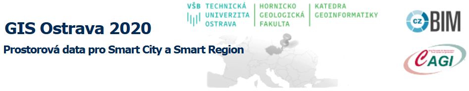
V dňoch 18. – 20.3.2020 sa konalo Sympózium GIS Ostrava. Táto akcia sa tradične koná na pôde VŠB-TU v Ostrave. Okolnosti súvisiace so šíriacim sa Koronavírusom (COVID-19) stretnutie v Ostrave tento rok neumožňovali. S ohľadom na uvedené organizátori vsadili na priebeh formou videokonferencie. Táto voľba sa ukázala ako veľmi dobrá. Organizátori si dali záležať a pripravili kvalitné podujatie, ktoré bolo […]
The post GIS Ostrava 2020 (report) appeared first on GISportal.cz.
Novinky z oblasti literatury [Knihovna geografie, byTopic]
24.3.2020 8:25 Katedra aplikované geoinformatiky a kartografie Přf UK V souvislosti s aktuální situací informujeme o změnách a novinkách v oblasti literatury.Sběrný box - upozornění
24.3.2020 8:24 ČÚZK /Urady/Katastralni-urady/Katastralni-urady/Katastralni-urad-pro-Stredocesky-kraj/Katastralni-pracoviste/KP-Beroun/O-uradu/Aktuality/Sberny-box-upozorneniSběrný box - upozornění
24.3.2020 8:24 ČÚZK - předpisy a opatření Katastrální úřad pro Středočeský kraj - Katastrální pracoviště Beroun zveřejnil novou aktualitu: Sběrný box - upozorněníUpozorňujeme na možnost učinit podání bezkontaktně do schránky umístěné na dveřích do čekárny! Lze tak podat i návrh na vklad v zalepené obálce. Uveďte v podání Váš mail, budeme Vás informovat o přijetí, případně vyzveme k zaplacení poplatku převodem na účet. Schránka je přístupná : pondělí a středa 11-16 hod, úterý a čtvrtek 8-14 hod, pátek 8-12hod. Schránka je pravidelně vybírána.
Sběrný box - upozornění
24.3.2020 8:24 ČÚZK - předpisy a opatření Český úřad zeměměřický a katastrální - Katastrální pracoviště Beroun zveřejnil novou aktualitu: Sběrný box - upozorněníUpozorňujeme na možnost učinit podání bezkontaktně do schránky umístěné na dveřích do čekárny! Lze tak podat i návrh na vklad v zalepené obálce. Uveďte v podání Váš mail, budeme Vás informovat o přijetí, případně vyzveme k zaplacení poplatku převodem na účet. Schránka je přístupná : pondělí a středa 11-16 hod, úterý a čtvrtek 8-14 hod, pátek 8-12hod. Schránka je pravidelně vybírána.
Mapa koronavirus COVID-19 pro novináře a média od společnosti T-Mapy
24.3.2020 8:14 GISportal.cz
S ohledem na aktuální vývoj koronaviru ve světě i České republice se společnost T-Mapy, skrze svůj tým Corpis Maps rozhodla vytvořit analytickou mapu pro novináře a média sledující vývoj v jednotlivých zemích za poslední den. Cílem této mapy je usnadnit médiím práci se zjišťováním a odvozováním důležitých informací, faktů a trendů ze složitých datových sad o výskytu […]
The post Mapa koronavirus COVID-19 pro novináře a média od společnosti T-Mapy appeared first on GISportal.cz.
Nový iPad Pro 2020 od Apple má v sobě lidarový skener
24.3.2020 2:15 GeoBusinessFirma Apple představila nové verze svých produktů. Jedním z nich je inovovaná verze tabletu iPad, který ve verzi Pro bude obsahovat lidarový skener. Je to poprvé, co se v konzumní elektronice objevuje lidar. Lidarový skener má dosah až pět metrů, funguje v interiéru i v exteriéru. Augmentovaná realita Apple intenzivně pracuje na rozvoji nástrojů pro […]
The post Nový iPad Pro 2020 od Apple má v sobě lidarový skener appeared first on GeoBusiness.
Xyzt.ai, COVID19CZ, Mapy.cz, Hexagon, Esri… všichni v boji s koronavirem Covid-19
24.3.2020 1:39 GeoBusinessVirus o velikosti jedné devítisetiny šířky lidského vlasu si během tří měsíců podmanil celý svět. Zatímco na začátku trvalo tři měsíce nakazit 100 tisíc lidí, tak poté, co se nákaza rozšířila po celém světě, koronaviru trvalo jen 12 dní na nakažení dalších 100 tisíc lidí. A to mluvíme pouze o identifikovaných případech. (V době psaní […]
The post Xyzt.ai, COVID19CZ, Mapy.cz, Hexagon, Esri… všichni v boji s koronavirem Covid-19 appeared first on GeoBusiness.
Prodloužení lhůt k podání nabídek v rámci zadávacích řízení Státního pozemkového úřadu
24.3.2020 0:00 Státní pozemkový úřad V souvislosti s vyhlášením nouzového stavu na území ČR upozorňujeme dodavatele, že Státní pozemkový úřad bude u právě probíhajících, respektive zahájených zadávacích řízeních, přistupovat k prodloužení lhůt pro podání nabídek. Lhůty budou prodlouženy v závislosti na délce trvání nouzového stavu, aktuálně to znamená do druhé poloviny dubna 2020.Informace ke konkrétním zadávacím řízením lze získat na profilu zadavatele E-ZAK, a to na detailu příslušné veřejné zakázky, dále ve Věstníku veřejných zakázek, případně v Úředním věstníku Evropské unie.