


![]()

zprávy
zdroje zpráv:Národní centrum pro kosmický průzkum SATCEN
27.2.2018 16:03 GeoBusiness V České republice už letos v červenci vznikne národní satelitní centrum SATCEN ČR. Ministerstvo obrany oznámilo, že na základě závazků vůči Severoatlantické alianci NATO ... PřečístGIS hackathon v Brně
27.2.2018 15:39 GeoBusiness Univerzita je místem, kde tráví svůj čas spousty studentů, vyučujících, zaměstnanců, obyvatel. Někdo hledá posluchárnu, někdo si zapomněl identifikační kartu, jiný si chce vybrat ... PřečístBentley acquires S-Cube Futuretech for concrete design tools
27.2.2018 14:46 Bentley SystemsPress Coverage
AEC Magazine, UK
Read the articleBentley buys S-Cube
27.2.2018 14:43 Bentley SystemsPress Coverage
International Construction/Construction Europe, UK
Read the articleBentley Systems Expands Concrete Building Design and Documentation
27.2.2018 14:37 Bentley SystemsPress Coverage
GeoConnexion, UK
Read the article3D technology reduces wastewater treatment plant design costs by 30 percent
27.2.2018 14:33 Bentley SystemsPress Coverage
Sustainability Matters, Australia/New Zealand
Read the articleBentley Be Inspired Award Winner 2017
27.2.2018 14:28 Bentley SystemsPress Coverage
EE Online, USA
Read the articleRada/odborný rada – správce informačních a komunikačních technologií
27.2.2018 10:47 ČÚZK - předpisy a opatření Katastrální úřad pro Plzeňský krajvypisuje výběrové řízení na místo
Rada/odborný rada – správce informačních a komunikačních technologií
Rada/odborný rada – správce informačních a komunikačních technologií
27.2.2018 10:47 ČÚZK - volná místa Katastrální úřad pro Plzeňský kraj vypisuje výběrové řízení na místo Rada/odborný rada – správce informačních a komunikačních technologiíRada/odborný rada – správce informačních a komunikačních technologií
27.2.2018 10:47 ČÚZK /Urady/Katastralni-urady/Katastralni-urady/Katastralni-urad-pro-Plzensky-kraj/Uredni-deska/Oznameni-a-jina-uredni-sdeleni/Volna-mista/rada-odborny-rada-–-spravce-informacnich-a-komunik20180227 Rada/odborný rada oddělení právních vztahů k nemovitostem
27.2.2018 10:47 ČÚZK - předpisy a opatření Katastrální úřad pro Středočeský kraj - Katastrální pracoviště Benešov Oznámení o vyhlášení výběrového řízení: Rada/odborný rada oddělení právních vztahů k nemovitostem V části "Úřední deska", v sekci "Oznámení a jiná úřední sdělení" bylo vystaveno "Oznámení o vyhlášení výběrového řízení na obsazení služebního místa Rada/odborný rada oddělení právních vztahů k nemovitostem"20180227 Rada/odborný rada oddělení právních vztahů k nemovitostem
27.2.2018 10:47 ČÚZK /Urady/Katastralni-urady/Katastralni-urady/Katastralni-urad-pro-Stredocesky-kraj/Katastralni-pracoviste/KP-Benesov/O-uradu/Aktuality/20161013Rada-odborny-rada-–-informatik-(4)Rada/odborný rada oddělení právních vztahů k nemovitostem
27.2.2018 10:45 ČÚZK - volná místa Katastrální úřad pro Středočeský kraj - Katastrální pracoviště Benešov vypisuje výběrové řízení na místo Rada/odborný rada oddělení právních vztahů k nemovitostemRada/odborný rada oddělení právních vztahů k nemovitostem
27.2.2018 10:45 ČÚZK - předpisy a opatření Katastrální úřad pro Středočeský kraj - Katastrální pracoviště Benešovvypisuje výběrové řízení na místo Rada/odborný rada oddělení právních vztahů k nemovitostem
Rada/odborný rada oddělení právních vztahů k nemovitostem
Assistant Professor position in GIScience, University at Buffalo
27.2.2018 9:22 The Department of Geography at the University at Buffalo is seeking outstanding applicants for a tenure-track faculty position (Assistant Professor) in Geographic Information Sciences (GIScience). The department is seeking highly qualified candidates who demonstrate, or show promise of establishing, a strong analytical research program in GIScience, which may include such topics as spatial data science, […]12. Kartografický den v Olomouci
27.2.2018 9:16 GISportal.cz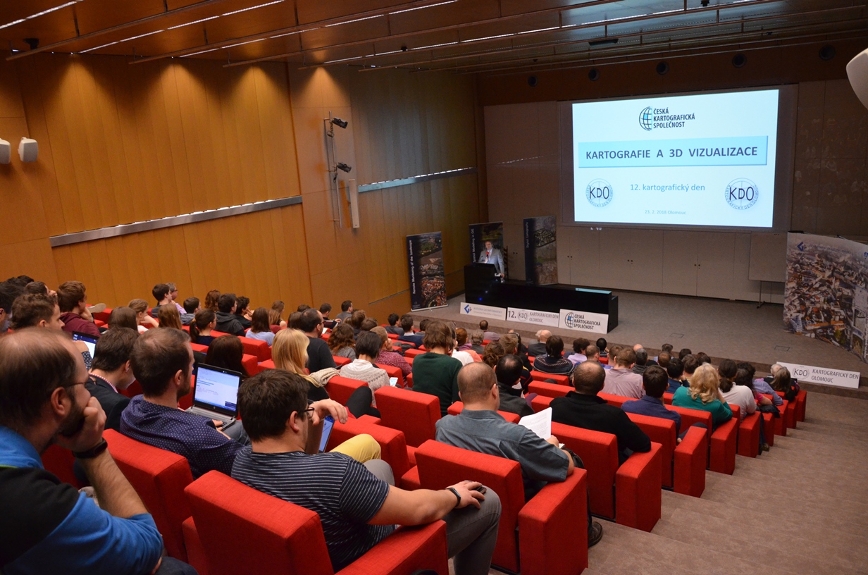
V pátek 23. února se v Olomouci sešli kartografové z Česka i Slovenska na každoroční akci Kartografický den, který měl letos zaměření na 3D vizualizaci v kartografii. Pod záštitou České kartografické společnosti tento den pořádá katedra geoinformatiky přírodovědecké fakulty, a to vždy poslední pátek v únoru. Tři zástupci komerční sféry a to firmy Mapy.cz, Melown Technologies SE a […]
The post 12. Kartografický den v Olomouci appeared first on GISportal.cz.
GISHackathon – Smart University
27.2.2018 8:10 GISportal.cz
15. března se od 15:00 na Mendlově univerzitě v Brně koná GISHackathon, na kterém pořadatelé plánují pomocí chytrých technologií zkvalitnit život studenta na univerzitě. Více informací je v pozvánce, vstup je zdarma.
The post GISHackathon – Smart University appeared first on GISportal.cz.
Unipetrol bude spravovat vozový park 500 vozidel s pomocí AMI
27.2.2018 7:41 GeoBusiness Skupina Unipetrol RPA dlouhé roky využívá systém pro správu majetku AMI od společnosti HSI. AMI je zkratka pro Moderní komplexní software pro facility management ... PřečístKompletní služba pro Mezinárodní kosmickou stanici
27.2.2018 7:39 Český Kosmický PortálRychlý přístup do vesmíru, vysokorychlostní datové připojení a unikátní umístění jsou hlavními výhodami nového komerčního podniku na Mezinárodní kosmické stanici. Jeho název je Bartolomeo. Jeho všestranný návrh dovoluje uskutečnění mnoha typů misí za konkurenceschopné ceny. A to již od příštího roku.
Kompletní služba pro Mezinárodní kosmickou stanici
27.2.2018 7:39 Český Kosmický PortálRychlý přístup do vesmíru, vysokorychlostní datové připojení a unikátní umístění jsou hlavními výhodami nového komerčního podniku na Mezinárodní kosmické stanici. Jeho název je Bartolomeo. Jeho všestranný návrh dovoluje uskutečnění mnoha typů misí za konkurenceschopné ceny. A to již od příštího roku.
Mapa: Kde se v Česku dýchá nejhůže
27.2.2018 7:00 Česká asociace pro geoinformace Fakt, že se na Ostravsku, Ústecku, v Praze a Brně dýchá hůře, než v ostatních oblastech Česka, asi nikoho nepřekvapí. Jak špatně se ale dýchá (nejen) lidem v ostatních koutech naší země a jak je na tom Česko v porovnání s Evropu? To se můžete dočíst v článku a přesvědčit v interaktivní mapě na serveruMapa: Kde se v Česku dýchá nejhůře
27.2.2018 7:00 Česká asociace pro geoinformace Fakt, že se na Ostravsku, Ústecku, v Praze a Brně dýchá hůře, než v ostatních oblastech Česka, asi nikoho nepřekvapí. Jak špatně se ale dýchá (nejen) lidem v ostatních koutech naší země a jak je na tom Česko v porovnání s Evropu? To se můžete dočíst v článku a přesvědčit v interaktivní mapě na serveruDroneShield Welcomes the Turnbull / Pyne Defence Export Strategy
27.2.2018 1:57 GISCafe.com Webcasts-Webinars SYDNEY, Feb. 26, 2018 — (PRNewswire) — On 29 January 2018, The Hon Christopher Pyne MP, Australian Minister for Defence Industry, …CoreLogic Reports Fourth Quarter and Full-Year 2017 Financial Results
27.2.2018 1:57 GISCafe.com Webcasts-Webinars Strong Operating Performance Highlighted by Revenue Outperformanceof Market Trends, Achievement of High End of Profit Guidance and
…
Drone Delivery Canada receives $7 Million from warrant acceleration
27.2.2018 1:57 GISCafe.com Webcasts-Webinars TORONTO, Feb. 26, 2018 — (PRNewswire) — Drone Delivery Canada 'DDC or the Company' (TSX.V:FLT OTC:TAKOF), is pleased to report the …Lokality výskytu národně významných druhů
27.2.2018 1:00 Cenia - Katalog metadat ČR - INSPIRE Lokality národně významných druhů převzaté z monitoringu ohrožených druhů, zajišťovaného Agenturou ochrany přírody a krajiny ČR; vrstva obsahuje jednoduché prvky (Singlepart Features); © AOPK ČR, 2016Státní pozemkový úřad – správce české krajiny
27.2.2018 0:00 Státní pozemkový úřad Výstava fotografií realizací pozemkových úprav se uskuteční v atraktivním prostředí - na střeše Národního zemědělského muzea.VÝSTAVA FOTOGRAFIÍ - Komplexní pozemkové úpravy
27.2.2018 0:00 Státní pozemkový úřad Realizace plánů společných zařízení na okresech Nymburk a Praha-východ pobočkou SPÚ v Nymburce.Výstava fotografií pozemkových úprav
27.2.2018 0:00 Státní pozemkový úřad Krajský pozemkový úřad pro Karlovarský kraj si Vás dovoluje pozvat na výstavu fotografií, které Vám představí výsledky pozemkových úprav v kraji.United Nations-led conference on space technology for water management opens in Islamabad
26.2.2018 21:06 GISCafe.com Webcasts-Webinars VIENNA, 26 February (United Nations Information Service) - More than 100 decision-makers, experts, educators and other stakeholders from around the …AirBUS: Hello, I am CIMON!
26.2.2018 21:03 GISCafe.com Webcasts-Webinars Airbus is developing the CIMON astronaut assistance system for the DLR Space Administration Alexander Gerst will test the technology …Creating and Maintaining a Microgrid: Tools to Get You from Concept to Reality to O&M
26.2.2018 16:05 Bentley SystemsPress Coverage
Renewable Energy World, USA
Read the articleKvalitní vzduch pro každého
26.2.2018 16:01 Český Kosmický PortálZačínající firma v jednom z podnikatelských inkubátorů ESA nabízí dostupné monitory kvality vzduchu pro domácnosti, školy a podniky. Využívá přitom technologii vyvinutou pro Mezinárodní kosmickou stanici.
Mapbox Launches Global Reality-Grade AR Location Platform
26.2.2018 15:41 GISCafe.com Webcasts-Webinars BARCELONA, Spain, Feb. 26, 2018 — (PRNewswire) — As static 2D maps fade away with the bezels of mobile phones, the future …Digital transformation is the only option
26.2.2018 15:39 Bentley SystemsPress Coverage
Control Engineering, USA
Read the articleMaxar Technologies announces William McCombe is stepping down as CFO, Anil Wirasekara appointed Interim CFO
26.2.2018 15:36 GISCafe.com Webcasts-Webinars SAN FRANCISCO and VANCOUVER, Feb. 26, 2018 — (PRNewswire) — Maxar Technologies Ltd. ("Maxar" or the "Company", formerly …Collaboration Leads to Consistency with this Design Software
26.2.2018 15:33 Bentley SystemsPress Coverage
Chemical Engineering Online, USA
Read the articleWhere the 3D Model Drives Field Equipment: Interview with Bentley Systems
26.2.2018 15:28 Bentley SystemsPress Coverage
AECCafe, USA
Read the articleThe Solutions Provider
26.2.2018 15:19 Bentley SystemsPress Coverage
Water & Wastewater Asia, Southeast Asia
Read the articleGSA scholarship allows young Europeans to explore space synergies
26.2.2018 13:55 European GNSS Agency.")
The European GNSS Agency (GSA), in cooperation with the Space Generation Advisory Council (SGAC), has launched the Young GSA – Space Systems Synergy Scholarship, giving European students and young professionals the chance to explore synergies between GNSS and Earth Observation.
The competition is a great opportunity for young Europeans to share their views on the possibilities that the integrated use of space infrastructure – global satellite communications, satellite navigation (including Galileo and EGNOS) and Earth Observation (including Copernicus) – can achieve.
Participants are asked to create a 30-second video complemented by a 400-word essay focused on answering the following question:
- While space programmes are capable of great achievements separately, it is through synergies that their true capabilities are unleashed. The best results will be achieved when telecommunications, satellite navigation and Earth Observation satellites and services collaborate to achieve common goals. How can synergies of these three types of space-based services, in effect ‘a system of systems’, be leveraged to help make our world safer and more sustainable? Use your imagination and give some realistic examples of your vision of what the future holds!
Need inspiration? Read this: European GNSS and Earth Observation: A promising convergence for sustainable development
The winner will receive up to USD 2 000 to be used to attend both the 7th Space Generation Fusion Forum on 15-16 April 2018, and the 34th Space Symposium, on 16-19 April 2018. Both events will be held in Colorado Springs, Colorado, USA.
The details
The scholarship is open to European students and young professionals aged 18 to 35. In order to participate, you must be a registered SGAC member. You can register for free membership here.
In addition to the video and essay, applicants must also submit their CV (with date of birth and country of citizenship). All submissions must be in English and must be received via the Scholarship's Submission Form no later than 23.59 GMT on 10 March 2018. The results will be announced on 15 March, 2018.
For more information, click here.
Media note: This feature can be republished without charge provided the European GNSS Agency (GSA) is acknowledged as the source at the top or the bottom of the story. You must request permission before you use any of the photographs on the site. If you republish, we would be grateful if you could link back to the GSA website (http://www.gsa.europa.eu).
GSA scholarship allows young people to explore space synergies
26.2.2018 13:55 European GNSS AgencyThe European GNSS Agency (GSA), in cooperation with the Space Generation Advisory Council (SGAC), has launched the Young GSA – Space Systems Synergy Scholarship, giving students and young professionals the chance to explore synergies between GNSS and Earth Observation.
The competition is a great opportunity for young people to share their views on the possibilities that the integrated use of space infrastructure – global satellite communications, satellite navigation (including Galileo and EGNOS) and Earth Observation (including Copernicus) – can achieve.
Participants are asked to create a 30-second video complemented by a 400-word essay focused on answering the following question:
- While space programmes are capable of great achievements separately, it is through synergies that their true capabilities are unleashed. The best results will be achieved when telecommunications, satellite navigation and Earth Observation satellites and services collaborate to achieve common goals. How can synergies of these three types of space-based services, in effect ‘a system of systems’, be leveraged to help make our world safer and more sustainable? Use your imagination and give some realistic examples of your vision of what the future holds!
Need inspiration? Read this: European GNSS and Earth Observation: A promising convergence for sustainable development
The winner will receive up to USD 2 000 to be used to attend both the 7th Space Generation Fusion Forum on 15-16 April 2018, and the 34th Space Symposium, on 16-19 April 2018. Both events will be held in Colorado Springs, Colorado, USA.
The details
The scholarship is open to European students and young professionals aged 18 to 35. In order to participate, you must be a registered SGAC member. You can register for free membership here.
In addition to the video and essay, applicants must also submit their CV (with date of birth and country of citizenship). All submissions must be in English and must be received via the Scholarship's Submission Form no later than 23.59 GMT on 29 March 2018.
For more information, click here.
Media note: This feature can be republished without charge provided the European GNSS Agency (GSA) is acknowledged as the source at the top or the bottom of the story. You must request permission before you use any of the photographs on the site. If you republish, we would be grateful if you could link back to the GSA website (http://www.gsa.europa.eu).
GSA scholarship allows young Europeans to explore space synergies
26.2.2018 13:55 European GNSS AgencyThe European GNSS Agency (GSA), in cooperation with the Space Generation Advisory Council (SGAC), has launched the Young GSA – Space Systems Synergy Scholarship, giving European students and young professionals the chance to explore synergies between GNSS and Earth Observation.
The competition is a great opportunity for young Europeans to share their views on the possibilities that the integrated use of space infrastructure – global satellite communications, satellite navigation (including Galileo and EGNOS) and Earth Observation (including Copernicus) – can achieve.
Participants are asked to create a 30-second video complemented by a 400-word essay focused on answering the following question:
- While space programmes are capable of great achievements separately, it is through synergies that their true capabilities are unleashed. The best results will be achieved when telecommunications, satellite navigation and Earth Observation satellites and services collaborate to achieve common goals. How can synergies of these three types of space-based services, in effect ‘a system of systems’, be leveraged to help make our world safer and more sustainable? Use your imagination and give some realistic examples of your vision of what the future holds!
Need inspiration? Read this: European GNSS and Earth Observation: A promising convergence for sustainable development
The winner will receive up to USD 2 000 to be used to attend both the 7th Space Generation Fusion Forum on 15-16 April 2018, and the 34rd Space Symposium, on 16-19 April 2018. Both events will be held in Colorado Springs, Colorado, USA.
The details
The scholarship is open to European students and young professionals aged 18 to 35. In order to participate, you must be a registered SGAC member. You can register for free membership here.
In addition to the video and essay, applicants must also submit their CV (with date of birth and country of citizenship). All submissions must be in English and must be received via the Scholarship's Submission Form no later than 23.59 GMT on 10 March 2018. The results will be announced on 15 March, 2018.
For more information, click here.
Media note: This feature can be republished without charge provided the European GNSS Agency (GSA) is acknowledged as the source at the top or the bottom of the story. You must request permission before you use any of the photographs on the site. If you republish, we would be grateful if you could link back to the GSA website (http://www.gsa.europa.eu).
GSA scholarship allows young people to explore space synergies
26.2.2018 13:55 European GNSS AgencyThe European GNSS Agency (GSA), in cooperation with the Space Generation Advisory Council (SGAC), has launched the Young GSA – Space Systems Synergy Scholarship, giving students and young professionals the chance to explore synergies between GNSS and Earth Observation.
The competition is a great opportunity for young people to share their views on the possibilities that the integrated use of space infrastructure – global satellite communications, satellite navigation (including Galileo and EGNOS) and Earth Observation (including Copernicus) – can achieve.
Participants are asked to create a 30-second video complemented by a 400-word essay focused on answering the following question:
- While space programmes are capable of great achievements separately, it is through synergies that their true capabilities are unleashed. The best results will be achieved when telecommunications, satellite navigation and Earth Observation satellites and services collaborate to achieve common goals. How can synergies of these three types of space-based services, in effect ‘a system of systems’, be leveraged to help make our world safer and more sustainable? Use your imagination and give some realistic examples of your vision of what the future holds!
Need inspiration? Read this: European GNSS and Earth Observation: A promising convergence for sustainable development
The winner will receive up to USD 2 000 to be used to attend both the 7th Space Generation Fusion Forum on 15-16 April 2018, and the 34th Space Symposium, on 16-19 April 2018. Both events will be held in Colorado Springs, Colorado, USA.
The details
The scholarship is open to European students and young professionals aged 18 to 35. In order to participate, you must be a registered SGAC member. You can register for free membership here.
In addition to the video and essay, applicants must also submit their CV (with date of birth and country of citizenship). All submissions must be in English and must be received via the Scholarship's Submission Form no later than 23.59 GMT on 15 March 2018.
For more information, click here.
Media note: This feature can be republished without charge provided the European GNSS Agency (GSA) is acknowledged as the source at the top or the bottom of the story. You must request permission before you use any of the photographs on the site. If you republish, we would be grateful if you could link back to the GSA website (http://www.gsa.europa.eu).
Smart city a geodézie. Rámcový program 24. mezinárodních geodetických dní
26.2.2018 11:47 GeoBusiness V letošním roce se Mezinárodní česko-slovensko-polské geodetické dny uskuteční již po čtyřiadvacáté. Od prvních geodetických dnů, uskutečněných již v roce 1995 v Žilině, došlo ... PřečístUpozornění na uzavření budovy úřadu dne 8.3.2018
26.2.2018 10:52 ČÚZK /Urady/Zememericke-a-katastralni-inspektoraty/Zememericke-a-katastralni-inspektoraty/Zememericky-a-katastralni-inspektorat-v-Pardubicic/O-uradu/Aktuality/Upozorneni-na-uzavreni-budovy-uradu-dne-8-3-2018Upozornění na uzavření budovy úřadu dne 8.3.2018
26.2.2018 10:52 ČÚZK - předpisy a opatření Zeměměřický a katastrální inspektorát v Pardubicích zveřejnil novou aktualitu: Z důvodu přerušení dodávky elektrické energie bude ve čtvrtek 8.3.2018 zcela uzavřena budova Katastrálního úřadu pro Pardubický kraj, ve které sídlí Zeměměřický a katastrální inspektorát v Pardubicích.Z tohoto důvodu bude celý úřad, včetně podatelny Zeměměřického a katastrálního inspektorátu v Pardubicích, zcela uzavřen.
Sběr dat pod vodní hladinou a jejich využití
26.2.2018 10:02 Zeměměřič Monitoring stavu dna pomocí měřící lodě CAPEREA byl představen na Konferenci GIS Esri.Vydání nových verzí QGIS a gvSIG
26.2.2018 8:25 GISportal.czPátek 23. února byl pro open source GIS opravdu důležitým datem. Nejen že po dlouhém čekání konečně spatřil světlo světa QGIS ve verzi 3.0, ale vyšla také nová verze softwaru, vyvíjeného na univerzitě ve Valencii, gvSIG. Všichni, kdo se už nemohou dočkat, až si nový QGIS vyzkouší, si můžou novou verzi stáhnout z Githubu. Hned […]
The post Vydání nových verzí QGIS a gvSIG appeared first on GISportal.cz.
Vydání nových verzí QGIS a gvSIG
26.2.2018 8:25 GISportal.czPátek 23. února byl pro open source GIS opravdu důležitým datem. Nejen že po dlouhém čekání konečně spatřil světlo světa QGIS ve verzi 3.0, ale vyšla také nová verze softwaru, spoluvyvíjeného na univerzitě ve Valencii, gvSIG. Všichni, kdo se už nemohou dočkat, až si nový QGIS vyzkouší, si můžou novou verzi stáhnout z Githubu. Hned […]
The post Vydání nových verzí QGIS a gvSIG appeared first on GISportal.cz.
Podnikatelé v geomatice se sdružili a mají svého předsedu
26.2.2018 8:18 GISportal.czV pondělí 12. února 2018 se uskutečnila první valná hromada nově vzniklé Asociace podnikatelů v geomatice (APG), což je sdružení podnikatelských subjektů podnikajících v oboru geodézie, geoinformatiky a subjektů zabývajících se sběrem dat a pozemkovými úpravami. Asociace podnikatelů v geomatice navazuje na Českou komoru zeměměřičů, která byla do APG transformována rozhodnutím valné hromady ČKZ dne 8. ledna […]
The post Podnikatelé v geomatice se sdružili a mají svého předsedu appeared first on GISportal.cz.
Trimble GIS Express 2018
26.2.2018 6:12 GeoBusiness Firma Geotronics Praha každoročně na začátku jara pořádá jednodenní představení nových technologií a inovací nejen z geodézie. Program Trimble GIS Express 2018 09.00 – ... PřečístTrimble Express 2018
26.2.2018 6:12 GeoBusiness Firma Geotronics Praha každoročně na začátku jara pořádá jednodenní představení nových technologií a inovací nejen z geodézie. Program Trimble Express 2018 09.00 – 09.30 ... PřečístBrownfieldy
26.2.2018 1:00 Cenia - Katalog metadat ČR - INSPIRE Brownfieldy z veřejné části Národní databáze brownfieldů spravovanou Agenturou pro podporu podnikání a investic.Oznámení o vyhlášení výběrového řízení na služební místo vrchní referent/rada, Pobočka Hradec Králové
26.2.2018 0:00 Státní pozemkový úřad Ústřední ředitelka Státního pozemkového úřadu, jako služební orgán příslušný podle § 10 odst. 1 písm. f) zákona č. 234/2014 Sb., o státní službě (dále jen „zákon“), vyhlašuje výběrové řízení na služební místo vrchní referent/rada, Pobočka Hradec Králové.Oznámení o vyhlášení výběrového řízení na služební místo vrchní referent/rada, Pobočka Strakonice
26.2.2018 0:00 Státní pozemkový úřad Ústřední ředitelka Státního pozemkového úřadu, jako služební orgán příslušný podle § 10 odst. 1 písm. f) zákona č. 234/2014 Sb., o státní službě (dále jen „zákon“), vyhlašuje výběrové řízení na služební místo vrchní referent/rada, Pobočka Strakonice.Oznámení o vyhlášení výběrového řízení na služební místo rada/odborný rada, Pobočka Klatovy
26.2.2018 0:00 Státní pozemkový úřad Ústřední ředitelka Státního pozemkového úřadu, jako služební orgán příslušný podle § 10 odst. 1 písm. f) zákona č. 234/2014 Sb., o státní službě (dále jen „zákon“), vyhlašuje výběrové řízení na služební místo rada/odborný rada, Pobočka Klatovy.Oznámení o vyhlášení 2. kola výběrového řízení na služební místo vedoucí oddělení ostatních veřejných zakázek, odbor veřejných zakázek
26.2.2018 0:00 Státní pozemkový úřad Ústřední ředitelka Státního pozemkového úřadu, jako služební orgán příslušný podle § 10 odst. 1 písm. f) zákona č. 234/2014 Sb., o státní službě (dále jen „zákon“), vyhlašuje výběrové řízení na služební místo vedoucí oddělení ostatních veřejných zakázek, odbor veřejných zakázek.Přihlaste své projekty do soutěže Year in Infrastructure 2018 Awards
25.2.2018 23:04 GeoBusiness Soutěž Year in Infrastructure Awards, známá častěji pod původním názvem Be Inspired Awards, pořádá od roku 2004 firma Bentley Systems. Do konce dubna 2018 ... PřečístÚprava finančních limitů veřejných zakázek
25.2.2018 21:31 GeoBusiness Nařízením vlády České republiky č. 471 ze dne 22. prosince 2017 byly upraveny finanční limity veřejných zakázek. Od 1. ledna 2018 platí nové finanční ... Přečíst"Utilities: a Portfolio of Connected Applications" by Susan Smith
25.2.2018 12:00 GISCafe.com Webcasts-WebinarsTomTom and Elektrobit Join Forces on ‘Electronic Horizon’ for Automated Driving
25.2.2018 9:00 GISCafe.com Webcasts-Webinars BARCELONA, Spain — (BUSINESS WIRE) — February 25, 2018 —TomTom (TOM2)
and Elektrobit (EB) will collaborate to …
Náš článek o testování UAV pro sběr dat o železnici mezi nejčtenějšími články 2017 v GIM International
24.2.2018 20:53 UpVision Náš článek o testování UAV mapování pro sběr dat o železnici se umístil mezi nejčtenějšími články za rok 2017 jednoho z největších světových komerčních časopisů o geoinformatice GIM International. Nejčtenějších 12 článků za minulý rok časopis odhalil ve speciálním čísle GIM Business Guide 2018.Současně náš článek o mapování Pražského hradu z UAV je mezi 7 nejvíce inspirativními články o využití UAV v tomto časopise. :-)
Více zde:
https://plus.google.com/u/0/b/115833877689730865211/+UpvisionCz1/posts/R7MPv2bMBDr
V České republice už letos v červenci vznikne národní satelitní centrum SATCEN ČR (TZ)
24.2.2018 8:07 GISportal.cz
Na základě závazků vůči Severoatlantické alianci v oblasti poskytování obrazového zpravodajství (tzv. IMINT – Imagery Intelligence) vznikne v České republice centrum pro kosmický průzkum SATCEN ČR. Satelitní centrum bude vytvořeno k 1. 7. 2018 v rámci Vojenského zpravodajství a bude plnit úkoly jak pro zpravodajskou podporu české armády a velitelských struktur NATO, tak pro státní […]
The post V České republice už letos v červenci vznikne národní satelitní centrum SATCEN ČR (TZ) appeared first on GISportal.cz.
BizVibe Announces Their List of the Top 10 Drone Manufacturers in India
24.2.2018 1:17 GISCafe.com Webcasts-Webinars LONDON — (BUSINESS WIRE) — February 23, 2018 —BizVibe,
a smart business networking platform for global B2B buyers …
3D Reality Mesh of Penn States University Park Campus
23.2.2018 21:21 Bentley SystemsPress Coverage
Lidar News, USA
Read the articleHighway design and 3D modeling
23.2.2018 21:13 Bentley SystemsPress Coverage
Planning & Building Control Today, UK
Read the articleNew project software developed by Bentley
23.2.2018 21:07 Bentley SystemsPress Coverage
World Highways, UK
Read the articleNurton welcomes global software business to Birmingham
23.2.2018 20:57 Bentley SystemsPress Coverage
Commercial News Media, UK
Read the articlePacific Gas & Electric Brownfield Substation Project Benefits from Reality Modeling
23.2.2018 20:53 Bentley SystemsPress Coverage
The BIM Hub, UK
Read the articleAirbus DS Communications Launches VESTA® Map Local to Improve 9-1-1 Location Accuracy
23.2.2018 19:37 GISCafe.com Webcasts-Webinars TEMECULA, Calif., Feb. 23, 2018 (GLOBE NEWSWIRE) -- Airbus DS Communications, a pioneer in public safety communications, announced today that it …Vricon launches Telco Suite at Mobile World Congress
23.2.2018 19:37 GISCafe.com Webcasts-Webinars McLean, Virginia, Feb. 23, 2018 (GLOBE NEWSWIRE) -- Vricon is pleased to announce that it is launching its Telco Suite at this year’s Mobile …SpaceChain Successfully Launches First Blockchain Node Into Low Earth Orbit
23.2.2018 16:35 GISCafe.com Webcasts-Webinars SINGAPORE, Feb. 23, 2018 — (PRNewswire) — On Feb 2, 2018, SpaceChain launched its first blockchain node into orbit. The satellite was …20180223 - volné místo - Rada/odborný rada v OAaD KP Rumburk
23.2.2018 14:14 ČÚZK /Urady/Katastralni-urady/Katastralni-urady/Katastralni-urad-pro-Ustecky-kraj/O-uradu/Aktuality/20180223-volne-misto-Rada-odborny-rada-v-OAaD20180223 - volné místo - Rada/odborný rada v OAaD KP Rumburk
23.2.2018 14:14 ČÚZK - předpisy a opatření Katastrální úřad pro Ústecký kraj - Katastrální pracoviště Rumburk zveřejnil novou aktualitu: Nabídka volného pracovního místa - Rada / odborný rada v oddělení aktualizace a dokumentace katastru nemovitostí Katastrálního pracoviště RumburkRada / odborný rada v oddělení aktualizace a dokumentace katastru nemovitostí Katastrálního pracoviš
23.2.2018 14:08 ČÚZK /Urady/Katastralni-urady/Katastralni-urady/Katastralni-urad-pro-Ustecky-kraj/Uredni-deska/Oznameni-a-jina-uredni-sdeleni/Volna-mista/Rada-odborny-rada-v-oddeleni-aktualizace-a-dokumRada / odborný rada v oddělení aktualizace a dokumentace katastru nemovitostí Katastrálního pracoviš
23.2.2018 14:08 ČÚZK - volná místa Katastrální úřad pro Ústecký kraj - Katastrální pracoviště Rumburk vypisuje výběrové řízení na místo Rada / odborný rada v oddělení aktualizace a dokumentace katastru nemovitostí Katastrálního pracovišRada / odborný rada v oddělení aktualizace a dokumentace katastru nemovitostí Katastrálního pracoviš
23.2.2018 14:08 ČÚZK - předpisy a opatření Katastrální úřad pro Ústecký kraj - Katastrální pracoviště Rumburkvypisuje výběrové řízení na místo
Rada / odborný rada v oddělení aktualizace a dokumentace katastru nemovitostí Katastrálního pracoviště Rumburk
20180223 Vrchní referent/ rada v oddělení dokumentace
23.2.2018 13:19 ČÚZK - předpisy a opatření Katastrální úřad pro Středočeský kraj - Katastrální pracoviště Kolín zveřejnil novou aktualitu: Vrchní referent/ rada v oddělení dokumentace V sekci "Volná místa" byly vystaveny nabídky tří pracovních pozic "vrchní referent/ rada v oddělení dokumentace"20180223 Vrchní referent/ rada v oddělení dokumentace
23.2.2018 13:19 ČÚZK /Urady/Katastralni-urady/Katastralni-urady/Katastralni-urad-pro-Stredocesky-kraj/Katastralni-pracoviste/KP-Kolin/O-uradu/Aktuality/20180223-Nabidka-tri-pracovnich-pozic-v-odboru-obnvrchní referent/ rada v oddělení dokumentace
23.2.2018 13:17 ČÚZK /Urady/Katastralni-urady/Katastralni-urady/Katastralni-urad-pro-Stredocesky-kraj/Volna-mista/vrchni-referent-rada-v-oddeleni-dokumentacevrchní referent/ rada v oddělení dokumentace
23.2.2018 13:17 ČÚZK - předpisy a opatření Katastrální úřad pro Středočeský kraj - Katastrální pracoviště Kolínvypisuje výběrové řízení na místo Vrchní referent/ rada v oddělení dokumentace
vrchní referent/ rada v oddělení dokumentace
vrchní referent/ rada v oddělení dokumentace
23.2.2018 13:17 ČÚZK - volná místa Katastrální úřad pro Středočeský kraj - Katastrální pracoviště Kolín vypisuje výběrové řízení na místo vrchní referent/ rada v oddělení dokumentaceVrhní referent/rada v oddělení aktualizace PI KN č. 1 na Katastrálním pracovišti Brno - venkov
23.2.2018 12:44 ČÚZK - předpisy a opatření Katastrální úřad pro Jihomoravský kraj - Katastrální pracoviště Brno-venkovvypisuje výběrové řízení na místo
Vrhní referent/rada v oddělení aktualizace PI KN č. 1 na Katastrálním pracovišti Brno - venkov
Vrhní referent/rada v oddělení aktualizace PI KN č. 1 na Katastrálním pracovišti Brno - venkov
23.2.2018 12:44 ČÚZK - volná místa Katastrální úřad pro Jihomoravský kraj - Katastrální pracoviště Brno-venkov vypisuje výběrové řízení na místo Vrhní referent/rada v oddělení aktualizace PI KN č. 1 na Katastrálním pracovišti Brno - venkovVrhní referent/rada v oddělení aktualizace PI KN č. 1 na Katastrálním pracovišti Brno - venkov
23.2.2018 12:44 ČÚZK /Urady/Katastralni-urady/Katastralni-urady/Katastralni-urad-pro-Jihomoravsky-kraj/Volna-mista/Vrhni-referent-rada-v-oddeleni-aktualizace-PI-KN-cRada/odborný rada v oddělení právních vztahů k nemovitostem na Katastrálním pracovišti Znojmo
23.2.2018 12:42 ČÚZK - předpisy a opatření Katastrální úřad pro Jihomoravský kraj - Katastrální pracoviště Znojmovypisuje přijímací řízení na služební místo
Rada/odborný rada v oddělení právních vztahů k nemovitostem na Katastrálním pracovišti Znojmo
Rada/odborný rada v oddělení právních vztahů k nemovitostem na Katastrálním pracovišti Znojmo
23.2.2018 12:42 ČÚZK - volná místa Katastrální úřad pro Jihomoravský kraj - Katastrální pracoviště Znojmo vypisuje výběrové řízení na místo Rada/odborný rada v oddělení právních vztahů k nemovitostem na Katastrálním pracovišti ZnojmoRada/odborný rada v oddělení právních vztahů k nemovitostem na Katastrálním pracovišti Znojmo
23.2.2018 12:42 ČÚZK /Urady/Katastralni-urady/Katastralni-urady/Katastralni-urad-pro-Jihomoravsky-kraj/Volna-mista/Rada-odborny-rada-v-oddeleni-pravnich-vztahu-k-(1)Odborný referent/vrchní referent v oddělení dokumentace KN na Katastrálním pracovišti Znojmo
23.2.2018 12:37 ČÚZK - předpisy a opatření Katastrální úřad pro Jihomoravský kraj - Katastrální pracoviště Znojmovypisuje výběrové řízení na místo
Odborný referent/vrchní referent v oddělení dokumentace KN na Katastrálním pracovišti Znojmo
Odborný referent/vrchní referent v oddělení dokumentace KN na Katastrálním pracovišti Znojmo
23.2.2018 12:37 ČÚZK /Urady/Katastralni-urady/Katastralni-urady/Katastralni-urad-pro-Jihomoravsky-kraj/Uredni-deska/Oznameni-a-jina-uredni-sdeleni/Volna-mista/Odborny-referent-vrchni-referent-v-oddeleni-do-(1)Odborný referent/vrchní referent v oddělení dokumentace KN na Katastrálním pracovišti Znojmo
23.2.2018 12:37 ČÚZK - volná místa Katastrální úřad pro Jihomoravský kraj - Katastrální pracoviště Znojmo vypisuje výběrové řízení na místo Odborný referent/vrchní referent v oddělení dokumentace KN na Katastrálním pracovišti ZnojmoOdborný referent v oddělení dokumentace KN na Katastrálním pracovišti Znojmo
23.2.2018 12:34 ČÚZK - předpisy a opatření Katastrální úřad pro Jihomoravský kraj - Katastrální pracoviště Znojmovypisuje výběrové řízení na místo
Odborný referent v oddělení dokumentace KN na Katastrálním pracovišti Znojmo
Odborný referent v oddělení dokumentace KN na Katastrálním pracovišti Znojmo
23.2.2018 12:34 ČÚZK - volná místa Katastrální úřad pro Jihomoravský kraj - Katastrální pracoviště Znojmo vypisuje výběrové řízení na místo Odborný referent v oddělení dokumentace KN na Katastrálním pracovišti ZnojmoOdborný referent v oddělení dokumentace KN na Katastrálním pracovišti Znojmo
23.2.2018 12:34 ČÚZK /Urady/Katastralni-urady/Katastralni-urady/Katastralni-urad-pro-Jihomoravsky-kraj/Uredni-deska/Oznameni-a-jina-uredni-sdeleni/Volna-mista/Odborny-referent-v-oddeleni-dokumentace-KN-na-KataOdborný rada v oddělení právních vztahů k nemovitostem na Katastrálním pracovišti Znojmo
23.2.2018 12:31 ČÚZK - předpisy a opatření Katastrální úřad pro Jihomoravský kraj - Katastrální pracoviště Znojmovypisuje výběrové řízení na místo
Odborný rada v oddělení právních vztahů k nemovitostem na Katastrálním pracovišti Znojmo
Odborný rada v oddělení právních vztahů k nemovitostem na Katastrálním pracovišti Znojmo
23.2.2018 12:31 ČÚZK - volná místa Katastrální úřad pro Jihomoravský kraj - Katastrální pracoviště Znojmo vypisuje výběrové řízení na místo Odborný rada v oddělení právních vztahů k nemovitostem na Katastrálním pracovišti ZnojmoOdborný rada v oddělení právních vztahů k nemovitostem na Katastrálním pracovišti Znojmo
23.2.2018 12:31 ČÚZK /Urady/Katastralni-urady/Katastralni-urady/Katastralni-urad-pro-Jihomoravsky-kraj/Uredni-deska/Oznameni-a-jina-uredni-sdeleni/Volna-mista/Odborny-rada-v-oddeleni-pravnich-vztahu-k-nemovitoOdborný referent v oddělení právních vztahů k nemovitostem na Katastrálním pracovišti Hodonín
23.2.2018 12:25 ČÚZK /Urady/Katastralni-urady/Katastralni-urady/Katastralni-urad-pro-Jihomoravsky-kraj/Uredni-deska/Oznameni-a-jina-uredni-sdeleni/Volna-mista/Odborny-referent-v-oddeleni-pravnich-vztahu-k-nemoOdborný referent v oddělení právních vztahů k nemovitostem na Katastrálním pracovišti Hodonín
23.2.2018 12:25 ČÚZK - předpisy a opatření Katastrální úřad pro Jihomoravský kraj - Katastrální pracoviště Hodonínvypisuje výběrové řízení na místo
Odborný referent v oddělení právních vztahů k nemovitostem na Katastrálním pracovišti Hodonín
Odborný referent v oddělení právních vztahů k nemovitostem na Katastrálním pracovišti Hodonín
23.2.2018 12:25 ČÚZK - volná místa Katastrální úřad pro Jihomoravský kraj - Katastrální pracoviště Hodonín vypisuje výběrové řízení na místo Odborný referent v oddělení právních vztahů k nemovitostem na Katastrálním pracovišti HodonínMapová aplikace Technická infr
23.2.2018 12:00 Jihočeský kraj Mapová aplikace Technická infrastruktura a mapová aplikace Zastavěné území byly aktualizovány k 22.2.2018.Mapová aplikace a mapová apli
23.2.2018 12:00 Jihočeský kraj Mapová aplikace a mapová aplikace byly aktualizovány k 22.2.2018.20180223 Nabídka dvou pracovních pozic
23.2.2018 11:54 ČÚZK /Urady/Katastralni-urady/Katastralni-urady/Katastralni-urad-pro-Stredocesky-kraj/Katastralni-pracoviste/KP-Rakovnik/O-uradu/Aktuality/20180223-Nabidka-tri-pracovnich-pozic-v-odboru-(1)20180223 Nabídka dvou pracovních pozic
23.2.2018 11:54 ČÚZK - předpisy a opatření Katastrální úřad pro Středočeský kraj - Katastrální pracoviště Rakovník zveřejnil novou aktualitu: Nabídka dvou pracovních pozic V sekci "Volná místa" byly vystaveny nabídky dvou pracovních pozic "rada/odborný rada v oddělení právních vztahů k nemovitostem a ekonom - asistent v odboru správy KN"ekonom - asistent v odboru správy KN
23.2.2018 11:44 ČÚZK - volná místa Katastrální úřad pro Středočeský kraj - Katastrální pracoviště Rakovník vypisuje výběrové řízení na místo ekonom - asistent v odboru správy KNekonom - asistent v odboru správy KN
23.2.2018 11:44 ČÚZK - předpisy a opatření Katastrální úřad pro Středočeský kraj - Katastrální pracoviště Rakovníkvypisuje výběrové řízení na místo Ekonom - asistent v odboru správy KN
ekonom - asistent v odboru správy KN
ekonom - asistent v odboru správy KN
23.2.2018 11:44 ČÚZK /Urady/Katastralni-urady/Katastralni-urady/Katastralni-urad-pro-Stredocesky-kraj/Volna-mista/ekonom-asistent-v-odboru-spravy-KNrada/odborný rada v oddělení právních vztahů k nemovitostem
23.2.2018 11:42 ČÚZK /Urady/Katastralni-urady/Katastralni-urady/Katastralni-urad-pro-Stredocesky-kraj/Volna-mista/rada-odborny-rada-v-oddeleni-pravnich-vztahu-k-nemrada/odborný rada v oddělení právních vztahů k nemovitostem
23.2.2018 11:42 ČÚZK - volná místa Katastrální úřad pro Středočeský kraj - Katastrální pracoviště Rakovník vypisuje výběrové řízení na místo rada/odborný rada v oddělení právních vztahů k nemovitostemrada/odborný rada v oddělení právních vztahů k nemovitostem
23.2.2018 11:42 ČÚZK - předpisy a opatření Katastrální úřad pro Středočeský kraj - Katastrální pracoviště Rakovníkvypisuje výběrové řízení na místo Rada/odborný rada v oddělení právních vztahů k nemovitostem
rada/odborný rada v oddělení právních vztahů k nemovitostem
20180223 Nabídka tří pracovních pozic v odboru obnovy katastrálního operátu
23.2.2018 11:36 ČÚZK - předpisy a opatření Katastrální úřad pro Středočeský kraj zveřejnil novou aktualitu: Nabídka tří pracovních pozic v odboru obnovy katastrálního operátu V sekci "Volná místa" byly vystaveny nabídky tří pracovních pozic "odborný rada - obnova katastrálního operátu, odborný referent - obnova katastrálního operátu a odborný referent/vrchní referent - obnova katastrálního operátu"20180223 Nabídka tří pracovních pozic v odboru obnovy katastrálního operátu
23.2.2018 11:36 ČÚZK /Urady/Katastralni-urady/Katastralni-urady/Katastralni-urad-pro-Stredocesky-kraj/O-uradu/Aktuality/20180223-Nabidka-tri-pracovnich-pozic-v-odboru-obnUpgradujeme GISportal – kampaň na Startovači
23.2.2018 11:30 GISportal.cz
GISportal.cz je česko-slovenský online časopis o geoinformatice, kartografii a geovědách obecně. Dneska jsme spustili kampaň na Startovači, na které chceme vybrat alespoň 30 tis. Kč, za které uděláme po sedmi letech nový webdesign a začneme platit naše redaktory. Vysbírané peníze nám postačí na cca 1-2 roky provozu. Budeme rádi, když nám přispějete, nebo budete sdílet odkaz na Startovač […]
The post Upgradujeme GISportal – kampaň na Startovači appeared first on GISportal.cz.
odborný referent/vrchní referent - obnova katastrálního operátu
23.2.2018 11:24 ČÚZK - předpisy a opatření Katastrální úřad pro Středočeský krajvypisuje výběrové řízení na místo Odborný referent/vrchní referent - obnova katastrálního operátu
odborný referent/vrchní referent - obnova katastrálního operátu