


![]()

zprávy
zdroje zpráv:odborný referent - obnova katastrálního operátu
23.2.2018 11:21 ČÚZK - předpisy a opatření Katastrální úřad pro Středočeský krajvypisuje výběrové řízení na místo Odborný referent - obnova katastrálního operátu
odborný referent - obnova katastrálního operátu
odborný referent - obnova katastrálního operátu
23.2.2018 11:21 ČÚZK /Urady/Katastralni-urady/Katastralni-urady/Katastralni-urad-pro-Stredocesky-kraj/Volna-mista/odborny-referent-obnova-katastralniho-operatuodborný referent - obnova katastrálního operátu
23.2.2018 11:21 ČÚZK - volná místa Katastrální úřad pro Středočeský kraj vypisuje výběrové řízení na místo odborný referent - obnova katastrálního operátuodborný rada - obnova katastrálního operátu
23.2.2018 11:19 ČÚZK - volná místa Katastrální úřad pro Středočeský kraj vypisuje výběrové řízení na místo odborný rada - obnova katastrálního operátuodborný rada - obnova katastrálního operátu
23.2.2018 11:19 ČÚZK /Urady/Katastralni-urady/Katastralni-urady/Katastralni-urad-pro-Stredocesky-kraj/Volna-mista/odborny-rada-obnova-katastralniho-operatuodborný rada - obnova katastrálního operátu
23.2.2018 11:19 ČÚZK - předpisy a opatření Katastrální úřad pro Středočeský krajvypisuje výběrové řízení na místo Odborný rada - obnova katastrálního operátu
odborný rada - obnova katastrálního operátu
Pracovní nabídka v Olomouci
23.2.2018 10:54 GISportal.cz
Společnost Atomicon, která sama sebe popisuje jako odborníky na specializovaná online GIS řešení, založená na Open source technologiích, hledá obchodního manažera pro Olomouc a okolí.
The post Pracovní nabídka v Olomouci appeared first on GISportal.cz.
Pracovní nabídka v Olomouci
23.2.2018 10:54 GISportal.czSpolečnost Atomicon, která sama sebe popisuje jako odborníky na specializovaná online GIS řešení, založená na Open source technologiích, hledá obchodního manažera pro Olomouc a okolí.
The post Pracovní nabídka v Olomouci appeared first on GISportal.cz.
Upgradujeme GISportal – kampaň na Startovači
23.2.2018 10:30 GISportal.cz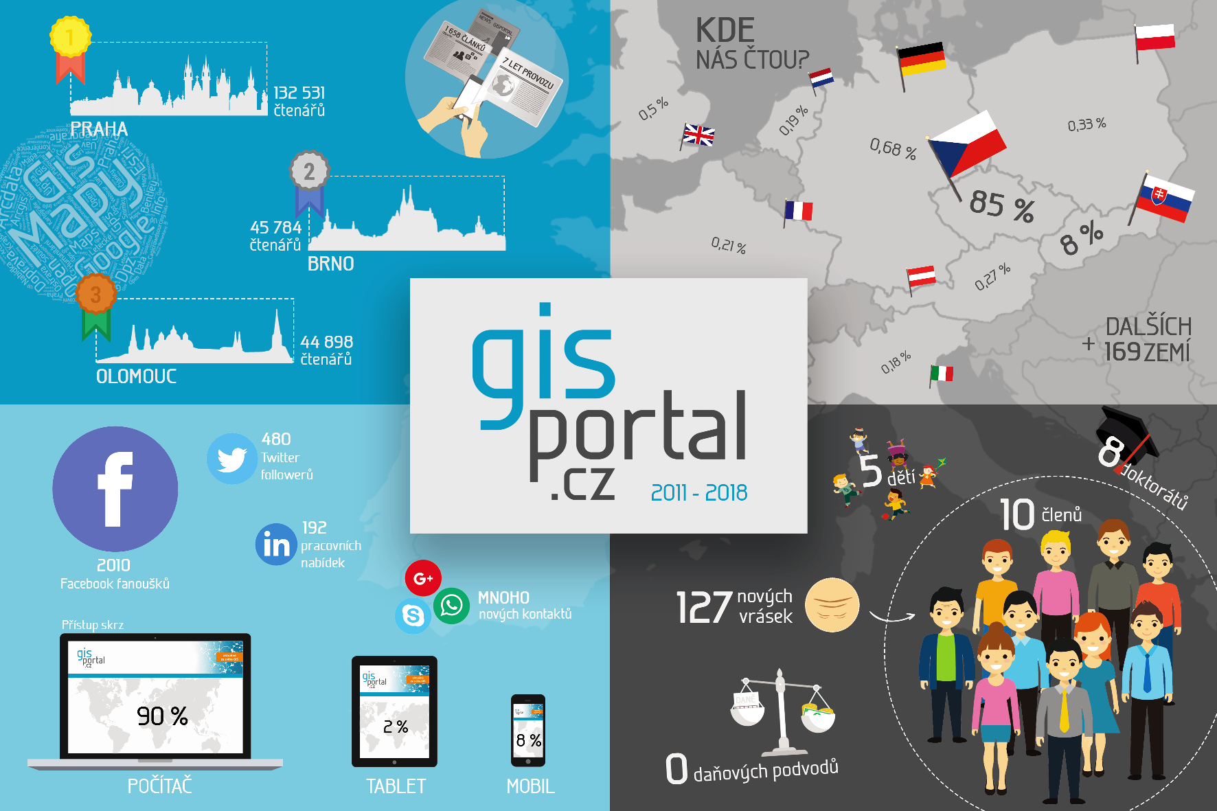
GISportal.cz je česko-slovenský online časopis o geoinformatice, kartografii a geovědách obecně. Dneska jsme spustili kampaň na Startovači, na které chceme vybrat alespoň 30 tis. Kč, za které uděláme po sedmi letech nový webdesign a začneme platit naše redaktory. Vysbírané peníze nám postačí na cca 1-2 roky provozu. Budeme rádi, když nám přispějete, nebo budete sdílet odkaz na Startovač […]
The post Upgradujeme GISportal – kampaň na Startovači appeared first on GISportal.cz.
Bering Strait
23.2.2018 10:05 ESA Observing the Earth
Earth observation image of the week: Sentinel-1 radar vision over the Bering Strait, which connects the Pacific and Arctic Oceans between Russia and Alaska
Earth from Space
23.2.2018 10:05 ESA Observing the Earth
Offering radar vision, Sentinel-1 takes us over the Bering Strait, where the sea ice is particularly low this winter
odborný referent v oddělení aktualizace katastru nemovitostí Katastrálního pracoviště Chrudim
23.2.2018 10:04 ČÚZK /Urady/Katastralni-urady/Katastralni-urady/Katastralni-urad-pro-Pardubicky-kraj/Uredni-deska/Oznameni-a-jina-uredni-sdeleni/Volna-mista/odborny-referent-v-oddeleni-aktualizace-katastru-nodborný referent v oddělení aktualizace katastru nemovitostí Katastrálního pracoviště Chrudim
23.2.2018 10:04 ČÚZK - volná místa Katastrální úřad pro Pardubický kraj - Katastrální pracoviště Chrudim vypisuje výběrové řízení na místo odborný referent v oddělení aktualizace katastru nemovitostí Katastrálního pracoviště Chrudimodborný referent v oddělení aktualizace katastru nemovitostí Katastrálního pracoviště Chrudim
23.2.2018 10:04 ČÚZK - předpisy a opatření Katastrální úřad pro Pardubický kraj - Katastrální pracoviště Chrudimvypisuje výběrové řízení na místo
odborný referent v oddělení aktualizace katastru nemovitostí Katastrálního pracoviště Chrudim
Is Galileo inside your phone?
23.2.2018 9:45 European GNSS Agency
With over 30 smartphone models currently on the market being Galileo-enabled – and many more on the way – chances are your phone is already taking advantage of all that Galileo has to offer. But how exactly does it work? Here, the European GNSS Agency (GSA) pulls back the curtain on Galileo functionality in smartphones.
When it comes to Galileo and smartphones, it all starts with the chip. As the chip is what powers a smartphone, it is often considered the most important part of the phone. The chip inside your phone contains multiple components, each supporting a specific function, such as image processing, graphic processing, and location.
To calculate your position, the chip depends on data provided by GNSS constellations, such as GPS, Galileo and Glonass. Most of the chips in smartphones today are multi-GNSS, meaning they use data from more than one GNSS constellation. If the multi-GNSS chip inside your phone includes Galileo, then your phone will be automatically using Galileo.
Galileo is not an application that you download; Galileo is a native feature of the smartphone itself.

Hint: Not sure if your phone receives Galileo signals? We recommend downloading the GPSTest app to find out. By checking the “status section”, you will find out whether Galileo satellites are used to compute your position (flag “EAU”, highlighted in green in the picture).
Although some chips only track GPS or Glonass signals, more and more are including Galileo in the mix. Over 95% of the satellite navigation chipset supply market supports Galileo in new products, including the leading manufacturers of smartphone chipsets: Broadcom, Qualcomm and Mediatek. Therefore many smartphones are already using Galileo, such as BQ, Samsung, Huawei, Apple, Asus, Google, LG, Meizu, Motorola, Nokia, OnePlus, Sony and Vernee. You can quickly find out whether or not your smartphone is Galileo-compatible by visiting www.useGalileo.eu.
Galileo gets you there
When a device is equipped with a Galileo-enabled chip, the phone works with standard applications, such as Google Maps and other location-based services. With a Galileo-enabled phone, the location is calculated using Galileo on top of GPS and other GNSS constellations. Although you will not be able to “see” the difference that this Galileo-capability makes, you will nonetheless benefit from the more accurate and reliable positioning that it provides.
With Galileo, the positioning information provided by smartphones is more accurate and reliable – particularly in urban environments where narrow streets and tall buildings can block satellite signals and limit the usefulness of many mobile services.
Whether using your phone to find a new restaurant, get to a meeting on time, or navigate to a nearby parking garage, Galileo is working to provide you with the best possible location information. Although you can’t see it, Galileo will get you there.
Media note: This feature can be republished without charge provided the European GNSS Agency (GSA) is acknowledged as the source at the top or the bottom of the story. You must request permission before you use any of the photographs on the site. If you republish, we would be grateful if you could link back to the GSA website (http://www.gsa.europa.eu).
Is Galileo inside your phone?
23.2.2018 9:45 European GNSS AgencyWith over 30 smartphone models currently on the market being Galileo-enabled – and many more on the way – chances are your phone is already taking advantage of all that Galileo has to offer. But how exactly does it work? Here, the European GNSS Agency (GSA) pulls back the curtain on Galileo functionality in smartphones.
When it comes to Galileo and smartphones, it all starts with the chip. As the chip is what powers a smartphone, it is often considered the most important part of the phone. The chip inside your phone contains multiple components, each supporting a specific function, such as image processing, graphic processing, and location.
To calculate your position, the chip depends on data provided by GNSS constellations, such as GPS, Galileo and Glonass. Most of the chips in smartphones today are multi-GNSS, meaning they use data from more than one GNSS constellation. If the multi-GNSS chip inside your phone includes Galileo, then your phone will be automatically using Galileo.
Galileo is not an application that you download; Galileo is a native feature of the smartphone itself.

Hint: Not sure if your phone receives Galileo signals? We recommend downloading the GPSTest app to find out. By checking the “status section”, you will find out whether Galileo satellites are used to compute your position (flag “EAU”, highlighted in green in the picture).
Although some chips only track GPS or Glonass signals, more and more are including Galileo in the mix. Over 95% of the satellite navigation chipset supply market supports Galileo in new products, including the leading manufacturers of smartphone chipsets: Broadcom, Qualcomm and Mediatek. Therefore many smartphones are already using Galileo, such as BQ, Samsung, Huawei, Apple, Asus, Google, LG, Meizu, Motorola, Nokia, OnePlus, Sony and Vernee. You can quickly find out whether or not your smartphone is Galileo-compatible by visiting www.useGalileo.eu.
Galileo gets you there
When a device is equipped with a Galileo-enabled chip, the phone works with standard applications, such as Google Maps and other location-based services. With a Galileo-enabled phone, the location is calculated using Galileo on top of GPS and other GNSS constellations. Although you will not be able to “see” the difference that this Galileo-capability makes, you will nonetheless benefit from the more accurate and reliable positioning that it provides.
With Galileo, the positioning information provided by smartphones is more accurate and reliable – particularly in urban environments where narrow streets and tall buildings can block satellite signals and limit the usefulness of many mobile services.
Whether using your phone to find a new restaurant, get to a meeting on time, or navigate to a nearby parking garage, Galileo is working to provide you with the best possible location information. Although you can’t see it, Galileo will get you there.
Media note: This feature can be republished without charge provided the European GNSS Agency (GSA) is acknowledged as the source at the top or the bottom of the story. You must request permission before you use any of the photographs on the site. If you republish, we would be grateful if you could link back to the GSA website (http://www.gsa.europa.eu).
Rada/odborný rada – rozhodování o povolení vkladu na Katastrálním pracovišti Třinec Katastrálního úř
23.2.2018 8:24 ČÚZK /Urady/Katastralni-urady/Katastralni-urady/Katastralni-urad-pro-Moravskoslezsky-kraj/Uredni-deska/Oznameni-a-jina-uredni-sdeleni/Volna-mista/Rada-odborny-rada-–-rozhodovani-o-povoleni-vkl-(2)Rada/odborný rada – rozhodování o povolení vkladu na Katastrálním pracovišti Třinec Katastrálního úř
23.2.2018 8:24 ČÚZK - předpisy a opatření Katastrální úřad pro Moravskoslezský kraj - Katastrální pracoviště Třinecvypisuje výběrové řízení na místo
Rada/odborný rada – rozhodování o povolení vkladu na Katastrálním pracovišti Třinec Katastrálního úřadu pro Moravskoslezský kraj
Rada/odborný rada – rozhodování o povolení vkladu na Katastrálním pracovišti Třinec Katastrálního úř
23.2.2018 8:24 ČÚZK - volná místa Katastrální úřad pro Moravskoslezský kraj - Katastrální pracoviště Třinec vypisuje výběrové řízení na místo Rada/odborný rada – rozhodování o povolení vkladu na Katastrálním pracovišti Třinec Katastrálního úřVrchní referent/rada – obnova katastrálního operátu v technickém odboru Katastrálního úřadu pro Mora
23.2.2018 8:22 ČÚZK - předpisy a opatření Katastrální úřad pro Moravskoslezský kraj - technický odborvypisuje výběrové řízení na místo
Vrchní referent/rada – obnova katastrálního operátu v technickém odboru Katastrálního úřadu pro Moravskoslezský kraj
Vrchní referent/rada – obnova katastrálního operátu v technickém odboru Katastrálního úřadu pro Mora
23.2.2018 8:22 ČÚZK - volná místa Katastrální úřad pro Moravskoslezský kraj - technický odbor vypisuje výběrové řízení na místo Vrchní referent/rada – obnova katastrálního operátu v technickém odboru Katastrálního úřadu pro MoraVrchní referent/rada – obnova katastrálního operátu v technickém odboru Katastrálního úřadu pro Mora
23.2.2018 8:22 ČÚZK /Urady/Katastralni-urady/Katastralni-urady/Katastralni-urad-pro-Moravskoslezsky-kraj/Uredni-deska/Oznameni-a-jina-uredni-sdeleni/Volna-mista/Vrchni-referent-rada-–-obnova-katastralniho-op-(4)Rada/odborný rada – správce informačních a komunikačních technologií
23.2.2018 8:21 ČÚZK - volná místa Katastrální úřad pro Moravskoslezský kraj vypisuje výběrové řízení na místo Rada/odborný rada – správce informačních a komunikačních technologiíRada/odborný rada – správce informačních a komunikačních technologií
23.2.2018 8:21 ČÚZK - předpisy a opatření Katastrální úřad pro Moravskoslezský krajvypisuje výběrové řízení na místo
Rada/odborný rada – správce informačních a komunikačních technologií
Rada/odborný rada – správce informačních a komunikačních technologií
23.2.2018 8:21 ČÚZK /Urady/Katastralni-urady/Katastralni-urady/Katastralni-urad-pro-Moravskoslezsky-kraj/Uredni-deska/Oznameni-a-jina-uredni-sdeleni/Volna-mista/Rada-odborny-rada-–-spravce-informacnich-a-kom-(1)Odborný rada – obnova katastrálního operátu na Katastrálním pracovišti Ostrava Katastrálního úřadu p
23.2.2018 8:19 ČÚZK - předpisy a opatření Katastrální úřad pro Moravskoslezský kraj - Katastrální pracoviště Ostravavypisuje výběrové řízení na místo
Odborný rada – obnova katastrálního operátu na Katastrálním pracovišti Ostrava Katastrálního úřadu pro Moravskoslezský kraj
Odborný rada – obnova katastrálního operátu na Katastrálním pracovišti Ostrava Katastrálního úřadu p
23.2.2018 8:19 ČÚZK - volná místa Katastrální úřad pro Moravskoslezský kraj - Katastrální pracoviště Ostrava vypisuje výběrové řízení na místo Odborný rada – obnova katastrálního operátu na Katastrálním pracovišti Ostrava Katastrálního úřadu pOdborný rada – obnova katastrálního operátu na Katastrálním pracovišti Ostrava Katastrálního úřadu p
23.2.2018 8:19 ČÚZK - předpisy a opatření Katastrální úřad pro Moravskoslezský kraj - Katastrální pracoviště Ostravavypisuje výběrové řízení na místo odborný rada – obnova katastrálního operátu na Katastrálním pracovišti Ostrava Katastrálního úřadu pro Moravskoslezský kraj
Odborný rada – obnova katastrálního operátu na Katastrálním pracovišti Ostrava Katastrálního úřadu pro Moravskoslezský kraj
Odborný rada – obnova katastrálního operátu na Katastrálním pracovišti Ostrava Katastrálního úřadu p
23.2.2018 8:19 ČÚZK /Urady/Katastralni-urady/Katastralni-urady/Katastralni-urad-pro-Moravskoslezsky-kraj/Uredni-deska/Oznameni-a-jina-uredni-sdeleni/Volna-mista/Odborny-rada-–-obnova-katastralniho-operatu-na-KatVrchní referent/rada – obnova katastrálního operátu na Katastrálním pracovišti Opava Katastrálního ú
23.2.2018 8:17 ČÚZK - předpisy a opatření Katastrální úřad pro Moravskoslezský kraj - Katastrální pracoviště Opavavypisuje výběrové řízení na místo vrchní referent/rada – obnova katastrálního operátu na Katastrálním pracovišti Opava Katastrálního úřadu pro Moravskoslezský kraj
Vrchní referent/rada – obnova katastrálního operátu na Katastrálním pracovišti Opava Katastrálního úřadu pro Moravskoslezský kraj
Vrchní referent/rada – obnova katastrálního operátu na Katastrálním pracovišti Opava Katastrálního ú
23.2.2018 8:17 ČÚZK - volná místa Katastrální úřad pro Moravskoslezský kraj - Katastrální pracoviště Opava vypisuje výběrové řízení na místo Vrchní referent/rada – obnova katastrálního operátu na Katastrálním pracovišti Opava Katastrálního úVrchní referent/rada – obnova katastrálního operátu na Katastrálním pracovišti Opava Katastrálního ú
23.2.2018 8:17 ČÚZK - předpisy a opatření Katastrální úřad pro Moravskoslezský kraj - Katastrální pracoviště Opavavypisuje výběrové řízení na místo
Vrchní referent/rada – obnova katastrálního operátu na Katastrálním pracovišti Opava Katastrálního úřadu pro Moravskoslezský kraj
Vrchní referent/rada – obnova katastrálního operátu na Katastrálním pracovišti Opava Katastrálního ú
23.2.2018 8:17 ČÚZK /Urady/Katastralni-urady/Katastralni-urady/Katastralni-urad-pro-Moravskoslezsky-kraj/Uredni-deska/Oznameni-a-jina-uredni-sdeleni/Volna-mista/Vrchni-referent-rada-–-obnova-katastralniho-op-(1)Odborný referent/vrchní referent – zápisy v řízení V a Z na Katastrálním pracovišti Opava Katastráln
23.2.2018 8:16 ČÚZK - volná místa Katastrální úřad pro Moravskoslezský kraj - Katastrální pracoviště Opava vypisuje výběrové řízení na místo Odborný referent/vrchní referent – zápisy v řízení V a Z na Katastrálním pracovišti Opava KatastrálnOdborný referent/vrchní referent – zápisy v řízení V a Z na Katastrálním pracovišti Opava Katastráln
23.2.2018 8:16 ČÚZK /Urady/Katastralni-urady/Katastralni-urady/Katastralni-urad-pro-Moravskoslezsky-kraj/Uredni-deska/Oznameni-a-jina-uredni-sdeleni/Volna-mista/Odborny-referent-vrchni-referent-–-zapisy-v-rizeniOdborný referent/vrchní referent – zápisy v řízení V a Z na Katastrálním pracovišti Opava Katastráln
23.2.2018 8:16 ČÚZK - předpisy a opatření Katastrální úřad pro Moravskoslezský kraj - Katastrální pracoviště Opavavypisuje výběrové řízení na místo
Odborný referent/vrchní referent – zápisy v řízení V a Z na Katastrálním pracovišti Opava Katastrálního úřadu pro Moravskoslezský kraj
Odborný referent/vrchní referent – zápisy v řízení V a Z na Katastrálním pracovišti Opava Katastráln
23.2.2018 8:16 ČÚZK - předpisy a opatření Katastrální úřad pro Moravskoslezský kraj - Katastrální pracoviště Opavavypisuje výběrové řízení na místo odborný referent/vrchní referent – zápisy v řízení V a Z na Katastrálním pracovišti Opava Katastrálního úřadu pro Moravskoslezský kraj
Odborný referent/vrchní referent – zápisy v řízení V a Z na Katastrálním pracovišti Opava Katastrálního úřadu pro Moravskoslezský kraj
Odborný rada - ředitel odboru právních vztahů k nemovitostem na Katastrálním pracovišti Ostrava Kata
23.2.2018 8:12 ČÚZK - volná místa Katastrální úřad pro Moravskoslezský kraj - Katastrální pracoviště Ostrava vypisuje výběrové řízení na místo Odborný rada - ředitel odboru právních vztahů k nemovitostem na Katastrálním pracovišti Ostrava KataOdborný rada - ředitel odboru právních vztahů k nemovitostem na Katastrálním pracovišti Ostrava Kata
23.2.2018 8:12 ČÚZK - předpisy a opatření Katastrální úřad pro Moravskoslezský kraj - Katastrální pracoviště Ostravavypisuje výběrové řízení na místo odborný rada - ředitel odboru právních vztahů k nemovitostem na Katastrálním pracovišti Ostrava Katastrálního úřadu pro Moravskoslezský kraj
Odborný rada - ředitel odboru právních vztahů k nemovitostem na Katastrálním pracovišti Ostrava Katastrálního úřadu pro Moravskoslezský kraj
Odborný rada - ředitel odboru právních vztahů k nemovitostem na Katastrálním pracovišti Ostrava Kata
23.2.2018 8:12 ČÚZK /Urady/Katastralni-urady/Katastralni-urady/Katastralni-urad-pro-Moravskoslezsky-kraj/Uredni-deska/Oznameni-a-jina-uredni-sdeleni/Volna-mista/Odborny-rada-reditel-odboru-pravnich-vztahu-k-(2)Odborný rada - ředitel odboru právních vztahů k nemovitostem na Katastrálním pracovišti Ostrava Kata
23.2.2018 8:12 ČÚZK - předpisy a opatření Katastrální úřad pro Moravskoslezský kraj - Katastrální pracoviště Ostravavypisuje výběrové řízení na místo
Odborný rada - ředitel odboru právních vztahů k nemovitostem na Katastrálním pracovišti Ostrava Katastrálního úřadu pro Moravskoslezský kraj
TopGis hledá specialistu mobilního mapování
23.2.2018 7:00 Česká asociace pro geoinformace Společnost TopGis hledá na letní sezónu Specialistu na mobilní mapování. Pokud se chcete dozvědět více, navštivte inzerát na webových stránkáchPodpořte GISportal na startovači!
23.2.2018 7:00 Česká asociace pro geoinformace GISportal.cz je česko-slovenský online časopis o geoinformatice, kartografii a geovědách obecně. Dnes byla spuštěna kampaň na Startovači, ve které je cílem vybrat alespoň 30 tis. Kč na nový webdesign a odměny pro redaktory. Vysbírané peníze postačí na jeden až dva rokyIntermap Technologies Reports 2017 Financial Results and New Task Order
23.2.2018 2:33 GISCafe.com Webcasts-Webinars DENVER, Feb. 22, 2018 — (PRNewswire) — (TSX: IMP) (ITMSF:BB) – Intermap Technologies Corporation ("Intermap" or the …HPE Reports Fiscal 2018 First Quarter Results
22.2.2018 22:41 GISCafe.com Webcasts-Webinars First quarter net revenue of $7.7 billion, up 11% from the prior-year period, and up 9% when adjusted for currencyFirst quarter GAAP diluted net …HP Inc. Reports Fiscal 2018 First Quarter Results
22.2.2018 22:41 GISCafe.com Webcasts-Webinars PALO ALTO, Calif., Feb. 22, 2018 (GLOBE NEWSWIRE) -- HP (NYSE:HPQ) ●First quarter GAAP diluted net earnings per share of $1.16, …
Cubic Strengthens C4ISR Business with Acquisition of MotionDSP
22.2.2018 22:41 GISCafe.com Webcasts-Webinars Acquisition to expand image enhancement and processing capabilities for Cubic Mission SolutionsSAN DIEGO, Feb. 22, 2018 — (PRNewswire) — …
Maxar Technologies reports fourth quarter and year end 2017 results
22.2.2018 22:41 GISCafe.com Webcasts-WebinarsGeomni Launches New Mobile App for Ground Imagery and Drone Inspections
22.2.2018 20:41 GISCafe.com Webcasts-Webinars Users can perform a complete UAV inspection from the safety of the groundLehi, Utah, February 22, 2018— Geomni, a Verisk business …
Sentera Adds Gimbaled NDVI Data Capture to DJI Phantom 4 Drone Series
22.2.2018 20:40 GISCafe.com Webcasts-Webinars 2018 growing season will offer most robust crop scouting options everMINNEAPOLIS, Feb. 22, 2018 — (PRNewswire) — Sentera today …
Cambridge-Based GeoSpock Secures an Additional $6.6M in Closing Its Series A Funding From Investors
22.2.2018 20:39 GISCafe.com Webcasts-Webinars Feb. 22 — (PRNewswire) — Unique architecture system powers the analysis of trillions of data points in secondsGeoSpock® - the …
USGIF Renews Academic Accreditation for the U.S. Air Force Academy
22.2.2018 20:21 GISCafe.com Webcasts-Webinars Collegiate accreditation program prepares students for GEOINT workforceHerndon, Virginia (February 22, 2018)—The United States Geospatial …
Integrating the ‘Constructioneering’ Workflow Together
22.2.2018 18:23 Bentley SystemsPress Coverage
GIM International, France/Benelux
Read the articleGoing Digital with Operationeering and Servitization
22.2.2018 18:20 Bentley SystemsPress Coverage
ReliabilityWeb, USA
Read the articleBIM Advancement
22.2.2018 18:18 Bentley SystemsPress Coverage
Civil + Structural Engineer, USA
Read the articleTomTom Launches New Navigation for Motorbike Riders: the TomTom RIDER 550
22.2.2018 17:10 GISCafe.com Webcasts-Webinars AMSTERDAM — (BUSINESS WIRE) — February 21, 2018 —TomTom (TOM2)
today announced a new navigation device created for …
Maxar Technologies' DigitalGlobe Expands Agreements with Two Major Commercial Technology Customers, Extending Its Leadership Position in High-Resolution Satellite Imagery
22.2.2018 17:10 GISCafe.com Webcasts-Webinars SAN FRANCISCO & WESTMINSTER, Colo. — (BUSINESS WIRE) — February 21, 2018 —DigitalGlobe, a Maxar Technologies Ltd. …
Dnes byla uvolněna nová verze
22.2.2018 17:00 GEUSware Dnes byla uvolněna nová verze programu GEUS 22.0.2 a to hlavně v souvislosti s připravovanými změnami v internetových službách poskytovaných katastrem a novou funkcí pro kompletní digitální podepisování GP:Přidána nová funkce pro kompletní podepisování GP i s možností podepsat GP "jedním tlačítkem". Tedy tato funkce kompletně nahrazuje nutnost používání externích programů pro podepisování jako jsou KDirSign a JSignPDF. Při dodržení pravidel popsaných v nápovědě programu pro ukládání příloh a souborů GP lze celý GP podepsat stisknutím jednoho tlačítka, což nejen zvyšuje pohodlí při zpracování GP, ale snižuje to i riziko, že dojde při podepisování k nějakému opomenutí.
V blízké době (řádově týdny) ukončí ČÚZK provoz služeb WSDP ve verzi 2.5 a nadále je bude poskytovat pouze ve verzi 2.6. Z tohoto důvodu přestane ve starší verzi programu GEUS 22.0 pracovat funkce "Podklady meření - WSGP". Novou verzi služeb WSDP 2.6 podporuje tato nová verze programu GEUS 22.0.2. Viz: http://www.cuzk.cz/Katastr-nemovitosti/Poskytovani-udaju-z-KN/Dalkovy-pristup/Webove-sluzby-dalkoveho-pristupu.aspx.
Podrobný popis všech změn ve verzi 22.0.2 naleznete zde.
Trimble RTX Technology Plays Key Role in General Motors' Super Cruise
22.2.2018 16:58 GISCafe.com Webcasts-Webinars Trimble's High-Accuracy GNSS Positioning Helps Bring Super Cruise to the RoadSUNNYVALE, Calif., Feb. 22, 2018 — (PRNewswire) — …
Leidos Holdings, Inc. Reports Fourth Quarter and Fiscal Year 2017 Results
22.2.2018 16:58 GISCafe.com Webcasts-WebinarsLeading Earthworks Contractor D&T Excavation Chooses Kespry for Inventory Management and Topographical Analysis
22.2.2018 16:53 GISCafe.com Webcasts-Webinars Oregon earthworks company selects Kespry drone-based aerial intelligence platform in partnership with John Deere dealer Papé MachineryMENLO PARK, …
20180222 - volné místo - Odborný/vrchní referent v oddělení právních vztahů na KP Ústí n.L.
22.2.2018 14:52 ČÚZK /Urady/Katastralni-urady/Katastralni-urady/Katastralni-urad-pro-Ustecky-kraj/O-uradu/Aktuality/20180222-volne-misto-Odborny-vrchni-referent-v20180222 - volné místo - Odborný/vrchní referent v oddělení právních vztahů na KP Ústí n.L.
22.2.2018 14:52 ČÚZK - předpisy a opatření Katastrální úřad pro Ústecký kraj - Katastrální pracoviště Ústí nad Labem zveřejnil novou aktualitu: Nabídka volného pracovního místa - Odborný / vrchní referent v oddělení právních vztahů k nemovitostem Katastrálního pracoviště Ústí n.L.Odborný / vrchní referent v oddělení právních vztahů k nemovitostem Katastrálního pracoviště Ústí na
22.2.2018 14:39 ČÚZK /Urady/Katastralni-urady/Katastralni-urady/Katastralni-urad-pro-Ustecky-kraj/Uredni-deska/Oznameni-a-jina-uredni-sdeleni/Volna-mista/Odborny-vrchni-referent-v-oddeleni-pravnich-vztaOdborný / vrchní referent v oddělení právních vztahů k nemovitostem Katastrálního pracoviště Ústí na
22.2.2018 14:39 ČÚZK - předpisy a opatření Katastrální úřad pro Ústecký kraj - Katastrální pracoviště Ústí nad Labemvypisuje výběrové řízení na místo
Odborný / vrchní referent v oddělení právních vztahů k nemovitostem Katastrálního pracoviště Ústí nad Labem
Odborný / vrchní referent v oddělení právních vztahů k nemovitostem Katastrálního pracoviště Ústí na
22.2.2018 14:39 ČÚZK - volná místa Katastrální úřad pro Ústecký kraj - Katastrální pracoviště Ústí nad Labem vypisuje výběrové řízení na místo Odborný / vrchní referent v oddělení právních vztahů k nemovitostem Katastrálního pracoviště Ústí naVýroční zpráva dle zákona č. 106/1999 Sb. za rok 2017
22.2.2018 14:32 ČÚZK /Urady/Katastralni-urady/Katastralni-urady/Katastralni-urad-pro-Stredocesky-kraj/Vyrocni-zpravy/Vyrocni-zprava-dle-zakona-c-106-1999-Sb-za-rok-2Výroční zpráva dle zákona č. 106/1999 Sb. za rok 20
22.2.2018 14:32 ČÚZK - předpisy a opatření Katastrální úřad pro Středočeský krajvydává výroční zprávu úřadu za rok
2017
Výroční zpráva dle zákona č. 106/1999 Sb. za rok 2017
22.2.2018 14:32 ČÚZK - předpisy a opatření Katastrální úřad pro Středočeský krajvydává výroční zprávu úřadu za rok
2017
Výroční zpráva dle zákona č. 106/1999 Sb. za rok 20
22.2.2018 14:32 ČÚZK /Urady/Katastralni-urady/Katastralni-urady/Katastralni-urad-pro-Stredocesky-kraj/Vyrocni-zpravy/Vyrocni-zprava-dle-zakona-c-106-1999-Sb-za-rok-2Swarm trio becomes a quartet
22.2.2018 14:09 ESA Observing the Earth
With the aim of making the best possible use of existing satellites, ESA and Canada have made a deal that turns Swarm into a four-satellite mission to shed even more light on space weather and features such as the aurora borealis.
Chorvatsko podepsalo dohodu o spolupráci s ESA
22.2.2018 9:51 Český Kosmický PortálChorvatská republika podepsala 19. února 2018 dohodu o spolupráci s ESA. Tato dohoda umožní Chorvatsku a ESA vytvořit rámec pro intenzivnější a konkrétnější spolupráci v programech a aktivitách ESA.
Chorvatsko podepsalo dohodu o spolupráci s ESA
22.2.2018 9:51 Český Kosmický PortálChorvatská republika podepsala 19. února 2018 dohodu o spolupráci s ESA. Tato dohoda umožní Chorvatsku a ESA vytvořit rámec pro intenzivnější a konkrétnější spolupráci v programech a aktivitách ESA.
vypadek el. mimo provoz
22.2.2018 8:40 ČÚZK - předpisy a opatření Katastrální úřad pro Pardubický kraj - Katastrální pracoviště Pardubice 8.3.2018 mimo provoz z technických důvodů Z DŮVODU PŘERUŠENÍ DODÁVKY ELEKTŘINY BUDE VE ČTVRTEK 8. 3. 2018 BUDOVA KATASTRÁLNÍHO ÚŘADU PRO PARDUBICKÝ KRAJ (KATASTRÁLNÍ PRACOVIŠTĚ PARDUBICE, ZEMĚMĚŘICKÝ ÚŘAD,ZEMĚMĚŘICKÝ A KATASTRÁLNÍ INSPEKTORÁT)
MIMO PROVOZ
vypadek el. mimo provoz
22.2.2018 8:40 ČÚZK /Urady/Katastralni-urady/Katastralni-urady/Katastralni-urad-pro-Pardubicky-kraj/Katastralni-pracoviste/KP-Pardubice/O-uradu/Aktuality/vypadek-el-mimo-provozvypadek el. mimo provoz
22.2.2018 8:39 ČÚZK /Urady/Katastralni-urady/Katastralni-urady/Katastralni-urad-pro-Pardubicky-kraj/O-uradu/Aktuality/vypadek-el-mimo-provozvypadek el. mimo provoz
22.2.2018 8:39 ČÚZK - předpisy a opatření Katastrální úřad pro Pardubický kraj 8.3.2018 mimo provoz z technických důvodůZ DŮVODU PŘERUŠENÍ DODÁVKY ELEKTŘINY BUDE VE ČTVRTEK 8. 3. 2018 BUDOVA KATASTRÁLNÍHO ÚŘADU PRO PARDUBICKÝ KRAJ (KATASTRÁLNÍ PRACOVIŠTĚ PARDUBICE, ZEMĚMĚŘICKÝ ÚŘAD,
ZEMĚMĚŘICKÝ A KATASTRÁLNÍ INSPEKTORÁT)
MIMO PROVOZ
Konsolidovaná vrstva ekosystémů
22.2.2018 1:00 Cenia - Katalog metadat ČR - INSPIRE Krajinný pokryv dělící území ČR do 41 kategorií (blíže v: HÖNIGOVÁ, I.; CHOBOT, K. (2014). Jemné předivo české krajiny v GIS: konsolidovaná vrstva ekosystémů. Ochrana přírody. 69, 4, s. 27-30. ISSN 210-258X.). Sestaveno ve spolupráci s CzechGlobe, Centrem výzkumu globální změny AV ČR, za podpory grantového projektu TD010066 „Integrované hodnocení ekosystémových služeb v ČR poskytnutého TAČR“. © CzechGlobe © AOPK ČR 2013, s využitím vlastních dat a dat ZABAGED (© ČÚZK 2012), Corine Land Cover 2006 (© EEA 2006), Urban Atlas 2006 (© EEA 2006), DIBAVOD (© VÚV TGM 2012).Aktualizace základního mapování biotopů
22.2.2018 1:00 Cenia - Katalog metadat ČR - INSPIRE Aktualizace vrstvy segmentů biotopů a relačních databází (biotopy, taxony) ve dvanáctiletém cyklu; zahájení aktualizace v roce 2007. Ve vrstvě a tabulkách jsou aktualizované a neaktualizované záznamy (pole ROK_AKT). Vrstva obsahuje hranice segmentů přírodních biotopů a biotopů silně ovlivněných nebo vytvořených člověkem z aktualizace základního mapování biotopů. Znalost rozšíření biotopů silně ovlivněných nebo vytvořených člověkem není plošná, vrstva poskytuje informace o rozšíření nepřírodních biotopů pouze na malé části území ČR.Data z mapování biotopů neposkytují vyčerpávající informaci o vegetaci, resp. biotopech daného území. Mapování je metodicky nastaveno na celostátní úrovni, a především efemérní biotopy tak může pominout. V lokálním měřítku proto představuje pouze zjednodušený podklad. Pro detailnější informaci je třeba vyhledat jiné datové zdroje. Základní mapování bylo provedeno v letech 2001–2005.Klasifikace biotopů viz CHYTRÝ, M.; KUČERA, T.; KOČÍ, M. (eds.) et al. (2010). Katalog biotopů České republiky. 2.upr. a rozš.vyd. Praha: Agentura ochrany přírody a krajiny ČR. 445 s. ISBN 978-80-87457-03-0.Popis charakteristik biotopů a segmentů viz platná metodika mapování biotopů (Portál ISOP/Mapování biotopů). Botanická nomenklatura převzata z Nálezové databáze OP (http://isop.nature.cz/redlist/v_nd_taxon_category.php). Vrstva obsahuje jednoduché prvky (Singlepart Features), kardinalita vztahu tabulek je 1 : N. © AOPK ČR, 2017Asociace podnikatelů v geomatice zvolila předsedu
21.2.2018 20:51 GeoBusiness V pondělí 12. února 2018 se konala první valná hromada nově vzniklé Asociace podnikatelů v geomatice (APG). Asociace podnikatelů v geomatice navazuje na Českou komoru zeměměřičů ... PřečístAsociace podnikatelů v geomatice zvolila předsedu a představenstvo
21.2.2018 20:51 GeoBusiness V pondělí 12. února 2018 se konala první valná hromada nově vzniklé Asociace podnikatelů v geomatice (APG). Asociace podnikatelů v geomatice navazuje na Českou komoru zeměměřičů ... PřečístGarmin Reports Solid Fiscal 2017 Revenue and Operating Income Growth; Proposes Dividend Increase
21.2.2018 17:58 GISCafe.com Webcasts-Webinars SCHAFFHAUSEN, Switzerland — (BUSINESS WIRE) — February 21, 2018 —Garmin Ltd. (Nasdaq: GRMN) today announced results for the …
Loveland Innovations Awarded Patent for Roofing Test Squares Using Aerial Drones
21.2.2018 17:57 GISCafe.com Webcasts-Webinars Patent is a remarkable example of how true innovation can revolutionize existing processesALPINE, Utah, Feb. 21, 2018 — (PRNewswire) — …
Bentley Systems expands its modelling software expertise for more joined-up approach to digital water
21.2.2018 15:45 Bentley SystemsPress Coverage
Global Water Intelligence, UK
Read the articleHighways England NOMS Project Wins Award for BIM Advancements
21.2.2018 15:42 Bentley SystemsPress Coverage
The BIM Hub, UK
Read the articleEvolution of 3D Design Models in Transportation
21.2.2018 15:38 Bentley SystemsPress Coverage
Civil + Structural Engineer, USA
Read the articleCarbon cycle
21.2.2018 15:01 ESA Observing the Earth
Discover how satellites and ESA are helping to improve our understanding of the carbon cycle and its role in climate change
SADI streamlines design of key cultural facility with BIM advancements
21.2.2018 14:44 Bentley SystemsPress Coverage
Inside Construction, Australia/New Zealand
Read the articleodborný referent v oddělení aktualizace KN II
21.2.2018 13:14 ČÚZK - předpisy a opatření Katastrální úřad pro Vysočinu - Katastrální pracoviště Jihlava zveřejnil novou aktualitu: Oznámení o vyhlášení výběrového řízení na služební místo odborný referent v oddělení aktualizace KN II Katastrálního pracoviště Jihlava na Katastrálním úřadu pro Vysočinu. Oznámení o vyhlášení výběrového řízení na služební místo odborný referent v oddělení aktualizace KN II Katastrálního pracoviště Jihlava na Katastrálním úřadu pro Vysočinu, místo výkonu služby Jihlava zde.odborný referent v oddělení aktualizace KN II
21.2.2018 13:14 ČÚZK /Urady/Katastralni-urady/Katastralni-urady/Katastralni-urad-pro-Vysocinu/Katastralni-pracoviste/KP-Jihlava/O-uradu/Aktuality/odborny-referent-v-oddeleni-aktualizace-KN-IIodborný referent v oddělení aktualizace KN II Katastrálního pracoviště Jihlava.
21.2.2018 13:11 ČÚZK - předpisy a opatření Katastrální úřad pro Vysočinu - Katastrální pracoviště Jihlavavypisuje výběrové řízení na místo odborný referent v oddělení aktualizace KN II Katastrálního pracoviště Jihlava.
odborný referent v oddělení aktualizace KN II Katastrálního pracoviště Jihlava.
odborný referent v oddělení aktualizace KN II Katastrálního pracoviště Jihlava.
21.2.2018 13:11 ČÚZK /Urady/Katastralni-urady/Katastralni-urady/Katastralni-urad-pro-Vysocinu/Uredni-deska/Oznameni-a-jina-uredni-sdeleni/Volna-mista/odborny-referent-v-oddeleni-aktualizace-KN-II-Kataodborný referent v oddělení aktualizace KN II Katastrálního pracoviště Jihlava.
21.2.2018 13:11 ČÚZK - volná místa Katastrální úřad pro Vysočinu - Katastrální pracoviště Jihlava vypisuje výběrové řízení na místo odborný referent v oddělení aktualizace KN II Katastrálního pracoviště Jihlava.Kde nás můžete v prvním pololetí potkat
21.2.2018 13:00 ARCDATA V průběhu první poloviny roku se s námi můžete potkat na nejrůznějších akcích. Chystáme se například na tyto konference:
- Sympozium GIS Ostrava (21.–23. března 2018)
- ISSS 2018 (9.–10. dubna 2018)
- GIVS 2018 (3.–4. května 2018)
Přijďte si s námi popovídat o novinkách v ArcGIS, 3D, Smart Cities, Insights for ArcGIS, dopadu GDPR na váš GIS nebo prostě o tom, co vás zrovna zajímá.
Mapová aplikace Územně analyti
21.2.2018 12:00 Jihočeský kraj Mapová aplikace Územně analytické podklady byla aktualizována k 20. 2. 2018.Mapová aplikace byla aktualiz
21.2.2018 12:00 Jihočeský kraj Mapová aplikace byla aktualizována k 20. 2. 2018.Zveřejnění obsahu informací poskytnutých na žádost dle zákona č. 106/1999 Sb. za rok 2018
21.2.2018 10:27 ČÚZK - předpisy a opatření Katastrální úřad pro Ústecký krajzveřejňuje obsah informace poskytnutých na žádost dle zákona č. 106/1999 Sb. za rok
2018
Zveřejnění obsahu informací poskytnutých na žádost dle zákona č. 106/1999 Sb. za rok 2018
21.2.2018 10:27 ČÚZK /Urady/Katastralni-urady/Katastralni-urady/Katastralni-urad-pro-Ustecky-kraj/Casto-hledane-informace/Poskytovani-informaci-106-1999-Sb/Zverejneni-obsahu-informaci-poskytnutych-na-za-(1)/Zverejneni-obsahu-informaci-poskytnutych-na-zadost20180221 - Plán revizí a OKO novým mapováním v okrese Ústí n.L.
21.2.2018 10:03 ČÚZK /Urady/Katastralni-urady/Katastralni-urady/Katastralni-urad-pro-Ustecky-kraj/Katastralni-pracoviste/KP-Usti-nad-Labem/O-uradu/Aktuality/20180221-Plan-revizi-a-OKO-novym-mapovanim-v-okr20180221 - Plán revizí a OKO novým mapováním v okrese Ústí n.L.
21.2.2018 10:03 ČÚZK - předpisy a opatření Katastrální úřad pro Ústecký kraj - Katastrální pracoviště Ústí nad Labem zveřejnil novou aktualitu: Zveřejňujeme plán revizí a obnovy katastrálního operátu novým mapováním v okrese Ústí nad Labem - dokument ke stažení zde .20180221 - Vyhlášení STOP-STAVU Radejčín
21.2.2018 9:34 ČÚZK /Urady/Katastralni-urady/Katastralni-urady/Katastralni-urad-pro-Ustecky-kraj/Katastralni-pracoviste/KP-Usti-nad-Labem/O-uradu/Aktuality/20180221-STOP-STAV-Radejcin20180221 - Vyhlášení STOP-STAVU Radejčín
21.2.2018 9:34 ČÚZK - předpisy a opatření Katastrální úřad pro Ústecký kraj - Katastrální pracoviště Ústí nad Labem zveřejnil novou aktualitu: Od 23. 2. 2018 bude vyhlášen tzv. STOP-STAV zápisů v katastrálním území Radejčín (obec Řehlovice) z důvodu plánovaného dokončení obnovy katastrálního operátu. V této závěrečné etapě obnovy katastrálního operátu nelze provádět změny v zápisech vlastnických a jiných věcných práv do tohoto operátu, tj. nelze provádět zápisy vkladem nebo záznamem.Předpokládané datum vyhlášení platnosti obnoveného operátu a ukončení STOP-STAVU je 26. 3. 2018.Základy práce v GIS se zaměřením na ArcGIS for Desktop
21.2.2018 1:00 VARS.czV tomto kurzu se seznámíte se základními principy GIS v prostředí SW ESRI ArcGIS for Desktop.
Základy ArcGIS Pro - přechod z ArcMap
21.2.2018 1:00 VARS.czV tomto kurzu se seznámíte s novou filozofií ESRI a s tím souvisejícími změnami v GIS řešeních.
Generel páteřních a hlavních cyklistických tras hl. m. Prahy
21.2.2018 1:00 Cenia - Katalog metadat ČR - INSPIRE plán rozvoje cyklistické dopravy v Praze - hlavní a páteřní trasyOGC seeks public comment on ‘SensorThings API Part 2 – Tasking Core’ Candidate Standard for use in the Internet of Things
20.2.2018 21:11 GISCafe.com Webcasts-Webinars SensorThings API allows developers to connect to various IoT devices and create innovative applications without needing to integrate the …Earth-i receives £2.7 million from UK Government to improve crop yield for African coffee farmers
20.2.2018 21:11 GISCafe.com Webcasts-WebinarsEuroGeographics announces new additions to open data for 2018
20.2.2018 20:08 GISCafe.com Webcasts-Webinars February 20, 2018 -- EuroGeographics has released a new version of EuroGlobalMap, its open data created from official national sources.Forty-five …
Bentley Systems acquires S-Cube Futuretech
20.2.2018 17:46 Bentley SystemsPress Coverage
Graphic Speak, USA
Read the articleWorld’s Most Advanced Weather Satellite Imager from Harris Corporation Set to Launch March 1; Will Cover Western US
20.2.2018 17:37 GISCafe.com Webcasts-Webinars Highlights:Complements GOES-East imager with western coverage
Expands improved weather monitoring …
Survey Says: More Oil Producers Moving Toward a Risk-based Approach for Asset Life Extension
20.2.2018 17:33 Bentley SystemsPress Coverage
Oil & Gas Australia, Australia/New Zealand
Read the articlePenn State goes virtual using Bentley’s ContextCapture
20.2.2018 17:29 Bentley SystemsPress Coverage
The BIM Hub, UK
Read the articleAll change – the evolution of data
20.2.2018 17:26 Bentley SystemsPress Coverage
World Highways, UK
Read the articleCollaboration leads to consistency with this design software
20.2.2018 17:21 Bentley SystemsPress Coverage
Chemical Engineering, USA
Read the article