


![]()

zprávy
zdroje zpráv:Omezení provozu budovy KP Děčín
24.2.2025 9:00 ČÚZK - předpisy a opatření Český úřad zeměměřický a katastrální zveřejnil novou aktualitu: Oznámení o omezení provozu budovy KP Děčín z důvodu plánovaného přerušení dodávky elektrické energie ve středu dne 12. 03. 2025.Omezení provozu budovy KP Děčín
24.2.2025 9:00 ČÚZK - předpisy a opatření Katastrální úřad pro Ústecký kraj - Katastrální pracoviště Děčín zveřejnil novou aktualitu: Oznámení o omezení provozu budovy KP Děčín z důvodu plánovaného přerušení dodávky elektrické energie ve středu dne 12. 03. 2025.DAEX DESIGN Pro 25 v akci
22.2.2025 19:02 ŠPINAR - softwareAkční bonusy s novou verzí DAEX DESIGN Pro do 26. 10. 2024! (DAEX Pila, DAEX Importér pro konfigurátor Blum a Postprocesor pro Altendorf.)
The post DAEX DESIGN Pro 25 v akci appeared first on ŠPINAR – software.
DAEX DESIGN Pro 25 v akci
22.2.2025 19:02 ŠPINAR - software Akční bonusy s novou verzí DAEX DESIGN Pro do 26. 10. 2024! (DAEX Pila, DAEX Importér pro konfigurátor Blum a Postprocesor pro Altendorf.)Přerušení provozu DP a WSDP ve čtvrtek 27.2.2025 od 16:30 do cca 21:00.
21.2.2025 14:56 ČÚZK /Aplikace-DP-do-KN/Aplikace-DP-do-KN/Archiv-DP/432422Přerušení provozu DP a WSDP ve čtvrtek 27.2.2025 od 16:30 do cca 21:00.
21.2.2025 14:56 Dálkový přístup k údajům KN ČR Vážení uživatelé,oznamujeme, že ve čtvrtek 27.2.2025 od 16:30 bude z provozních důvodů zcela přerušen provoz Dálkového přístupu i Webových služeb dálkového přístupu. Obnovení provozu předpokládáme cca v 21:00. U této verze nedochází ke změně verze webových služeb.
Za komplikace tímto způsobené se omlouváme a děkujeme za pochopení.
Přerušení provozu DP a WSDP ve čtvrtek 27.2.2025 od 16:30 do cca 21:00.
21.2.2025 14:56 ČÚZK - předpisy a opatření Vážení uživatelé,oznamujeme, že ve čtvrtek 27.2.2025 od 16:30 bude z provozních důvodů zcela přerušen provoz Dálkového přístupu i Webových služeb dálkového přístupu. Obnovení provozu předpokládáme cca v 21:00. U této verze nedochází ke změně verze webových služeb.
Za komplikace tímto způsobené se omlouváme a děkujeme za pochopení.
řízení o údajích SGI v odboru GI KN Katastrálního pracoviště České Budějovice ID SM 30000133/3000375
21.2.2025 13:58 ČÚZK - volná místa Katastrální úřad pro Jihočeský kraj Katastrální pracoviště České Budějovice vypisuje výběrové řízení na místo řízení o údajích SGI v odboru GI KN Katastrálního pracoviště České Budějovice ID SM 30000133/3000375řízení o údajích SGI v odboru GI KN Katastrálního pracoviště České Budějovice ID SM 30000133/3000375
21.2.2025 13:58 ČÚZK /Urady/Katastralni-urady/Katastralni-urady/Katastralni-urad-pro-Jihocesky-kraj/Uredni-deska/Oznameni-a-jina-uredni-sdeleni/Volna-mista/DMS/rizeni-o-udajich-SGI-v-odboru-GI-KN-Katastralniho-řízení o údajích SGI v odboru GI KN Katastrálního pracoviště České Budějovice ID SM 30000133/3000375
21.2.2025 13:58 ČÚZK - předpisy a opatření Katastrální úřad pro Jihočeský kraj Katastrální pracoviště České Budějovicevypisuje výběrové řízení na místo
řízení o údajích SGI v odboru GI KN Katastrálního pracoviště České Budějovice ID SM 30000133/30003757
Výroční zpráva dle zákona č. 106/1999 Sb. za rok 2024
21.2.2025 13:50 ČÚZK /Urady/Katastralni-urady/Katastralni-urady/Katastralni-urad-pro-Zlinsky-kraj/Vyrocni-zpravy/Vyrocni-zprava-dle-zakona-c-106-1999-Sb-za-rok-(6)Výroční zpráva dle zákona č. 106/1999 Sb. za rok 2024
21.2.2025 13:50 ČÚZK - předpisy a opatření Katastrální úřad pro Zlínský krajvydává výroční zprávu úřadu za rok
2024
zápisy v řízení V a Z v oddělení dokumentace KN Katastrálního pracoviště Č. Budějovice ID SM 3000014
21.2.2025 13:03 ČÚZK - předpisy a opatření Katastrální úřad pro Jihočeský kraj Katastrální pracoviště České Budějovicevypisuje výběrové řízení na místo
zápisy v řízení V a Z v oddělení dokumentace KN Katastrálního pracoviště Č. Budějovice ID SM 30000146/30003770
zápisy v řízení V a Z v oddělení dokumentace KN Katastrálního pracoviště Č. Budějovice ID SM 3000014
21.2.2025 13:03 ČÚZK /Urady/Katastralni-urady/Katastralni-urady/Katastralni-urad-pro-Jihocesky-kraj/Uredni-deska/Oznameni-a-jina-uredni-sdeleni/Volna-mista/DMS/zapisy-v-rizeni-V-a-Z-v-oddeleni-dokumentace-KN-Kazápisy v řízení V a Z v oddělení dokumentace KN Katastrálního pracoviště Č. Budějovice ID SM 3000014
21.2.2025 13:03 ČÚZK - volná místa Katastrální úřad pro Jihočeský kraj Katastrální pracoviště České Budějovice vypisuje výběrové řízení na místo zápisy v řízení V a Z v oddělení dokumentace KN Katastrálního pracoviště Č. Budějovice ID SM 3000014rozhodování o povolení vkladu v oddělení právních vztahů k nemovitostem Katastrálního pracoviště Jin
21.2.2025 11:49 ČÚZK - volná místa Katastrální úřad pro Jihočeský kraj Katastrální pracoviště Jindřichův Hradec vypisuje výběrové řízení na místo rozhodování o povolení vkladu v oddělení právních vztahů k nemovitostem Katastrálního pracoviště Jinrozhodování o povolení vkladu v oddělení právních vztahů k nemovitostem Katastrálního pracoviště Jin
21.2.2025 11:49 ČÚZK - předpisy a opatření Katastrální úřad pro Jihočeský kraj Katastrální pracoviště Jindřichův Hradecvypisuje výběrové řízení na místo
rozhodování o povolení vkladu v oddělení právních vztahů k nemovitostem Katastrálního pracoviště Jindřichův Hradec ID SM 30000180/30003804
rozhodování o povolení vkladu v oddělení právních vztahů k nemovitostem Katastrálního pracoviště Jin
21.2.2025 11:49 ČÚZK /Urady/Katastralni-urady/Katastralni-urady/Katastralni-urad-pro-Jihocesky-kraj/Uredni-deska/Oznameni-a-jina-uredni-sdeleni/Volna-mista/DMS/rozhodovani-o-povoleni-vkladu-v-oddeleni-pravn-(1)Ukázka realizace modemové trasy
21.2.2025 11:18 Hrdlička Geodezie v souvislostech – slogan naší firmy neznamená jen provádění čistě geodetických pracírozhodování o povolení vkladu v oddělení právních vztahů k nemovitostem Katastrálního pracoviště Jin
21.2.2025 11:07 ČÚZK /Urady/Katastralni-urady/Katastralni-urady/Katastralni-urad-pro-Jihocesky-kraj/Uredni-deska/Oznameni-a-jina-uredni-sdeleni/Volna-mista/DMS/rozhodovani-o-povoleni-vkladu-v-oddeleni-pravnich-rozhodování o povolení vkladu v oddělení právních vztahů k nemovitostem Katastrálního pracoviště Jin
21.2.2025 11:07 ČÚZK - předpisy a opatření Katastrální úřad pro Jihočeský kraj Katastrální pracoviště Jindřichův Hradecvypisuje výběrové řízení na místo
rozhodování o povolení vkladu v oddělení právních vztahů k nemovitostem Katastrálního pracoviště Jindřichův Hradec ID SM 30000179/30003803
rozhodování o povolení vkladu v oddělení právních vztahů k nemovitostem Katastrálního pracoviště Jin
21.2.2025 11:07 ČÚZK - volná místa Katastrální úřad pro Jihočeský kraj Katastrální pracoviště Jindřichův Hradec vypisuje výběrové řízení na místo rozhodování o povolení vkladu v oddělení právních vztahů k nemovitostem Katastrálního pracoviště JinEarth from Space: Tokyo, Japan
21.2.2025 10:00 ESA Observing the Earth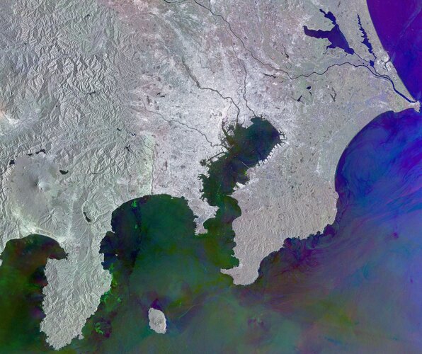 Image:
This Copernicus Sentinel-1 radar image shows Tokyo and its metropolitan area, the largest urban agglomeration in the world.
Image:
This Copernicus Sentinel-1 radar image shows Tokyo and its metropolitan area, the largest urban agglomeration in the world.
Rada – rozhodování o povolení vkladu
21.2.2025 7:21 ČÚZK - volná místa Katastrální úřad pro Moravskoslezský kraj Katastrální pracoviště Bruntál vypisuje výběrové řízení na místo Rada – rozhodování o povolení vkladuRada – rozhodování o povolení vkladu
21.2.2025 7:21 ČÚZK /Urady/Katastralni-urady/Katastralni-urady/Katastralni-urad-pro-Moravskoslezsky-kraj/Uredni-deska/Oznameni-a-jina-uredni-sdeleni/Volna-mista/DMS/Rada-–-rozhodovani-o-povoleni-vkladuRada – rozhodování o povolení vkladu
21.2.2025 7:21 ČÚZK - předpisy a opatření Katastrální úřad pro Moravskoslezský kraj Katastrální pracoviště Bruntálvypisuje výběrové řízení na místo
Rada – rozhodování o povolení vkladu
Two atmospheric missions on one satellite
20.2.2025 14:44 ESA Observing the Earth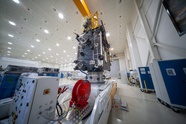
The second of the Meteosat Third Generation (MTG) satellites and the first instrument for the Copernicus Sentinel-4 mission are fully integrated and, having completed their functional and environmental tests, they are now ready to embark on their journey to the US for launch this summer.
Nové verze 17.13
20.2.2025 12:41 GEPROPřipravili jsme pro vás nové verze 17.13 našich produktů. Stahovat je můžete z obvyklého umístění na našem download serveru. Novinky, které jsme pro vás nachystali: KOKEŠ MISYS PROLAND KOKEŠ Práce s daty Selekce vrstev: doplněna možnost přidat, změnit či odebrat definované skupiny vrstev. Zrychleno otevírání projektů s velkým počtem souborů. Geodetické funkce GEPLAN: oprava výpisu […]
Článek Nové verze 17.13 se nejdříve objevil na GEPRO.
Zveřejnění obsahu informací poskytnutých na žádost dle zákona č. 106/1999 Sb. za rok 2025
20.2.2025 12:19 ČÚZK - předpisy a opatření Katastrální úřad pro Olomoucký krajzveřejňuje obsah informace poskytnutých na žádost dle zákona č. 106/1999 Sb. za rok 2025
2025
Zveřejnění obsahu informací poskytnutých na žádost dle zákona č. 106/1999 Sb. za rok 2025
20.2.2025 12:19 ČÚZK /Urady/Katastralni-urady/Katastralni-urady/Katastralni-urad-pro-Olomoucky-kraj/Casto-hledane-informace/Poskytovani-informaci-106-1999-Sb/Zverejneni-obsahu-informaci-poskytnutych-na-za-(1)/Zverejneni-obsahu-informaci-poskytnutych-na-za-(5)Rada oddělení aktualizace PI KN č.1 na Katastrálním pracovišti Brno - venkov
20.2.2025 11:58 ČÚZK - volná místa Katastrální úřad pro Jihomoravský kraj Katastrální pracoviště Brno-venkov vypisuje výběrové řízení na místo Rada oddělení aktualizace PI KN č.1 na Katastrálním pracovišti Brno - venkovRada oddělení aktualizace PI KN č.1 na Katastrálním pracovišti Brno - venkov
20.2.2025 11:58 ČÚZK /Urady/Katastralni-urady/Katastralni-urady/Katastralni-urad-pro-Jihomoravsky-kraj/Uredni-deska/Oznameni-a-jina-uredni-sdeleni/Volna-mista/DMS/Rada-oddeleni-aktualizace-PI-KN-c-1-na-KatastralniRada oddělení aktualizace PI KN č.1 na Katastrálním pracovišti Brno - venkov
20.2.2025 11:58 ČÚZK - předpisy a opatření Katastrální úřad pro Jihomoravský kraj Katastrální pracoviště Brno-venkovvypisuje výběrové řízení na místo
Rada oddělení aktualizace PI KN č.1 na Katastrálním pracovišti Brno - venkov
rada - návrh zápisu, kontrola a zplatnění
20.2.2025 10:54 ČÚZK /Urady/Katastralni-urady/Katastralni-urady/Katastralni-urad-pro-hlavni-mesto-Prahu/O-uradu/Aktuality/rada-navrh-zapisu,-kontrola-a-zplatneni-(4)rada - návrh zápisu, kontrola a zplatnění
20.2.2025 10:54 ČÚZK - předpisy a opatření Katastrální úřad pro hlavní město Prahu zveřejnil novou aktualitu: Ředitelka úřadu vyhlašuje výběrové řízení na pozici:rada - návrh zápisu, kontrola a zplatnění
rada - návrh zápisu, kontrola a zplatnění
20.2.2025 10:48 ČÚZK /Urady/Katastralni-urady/Katastralni-urady/Katastralni-urad-pro-hlavni-mesto-Prahu/Uredni-deska/Oznameni-a-jina-uredni-sdeleni/Volna-mista/rada-navrh-zapisu,-kontrola-a-zplatneni-(4)rada - návrh zápisu, kontrola a zplatnění
20.2.2025 10:48 ČÚZK - volná místa Katastrální úřad pro hlavní město Prahu vypisuje výběrové řízení na místo rada - návrh zápisu, kontrola a zplatněnírada - návrh zápisu, kontrola a zplatnění
20.2.2025 10:48 ČÚZK - předpisy a opatření Katastrální úřad pro hlavní město Prahuvypisuje výběrové řízení na místo
rada - návrh zápisu, kontrola a zplatnění
rada – revize katastrálního operátu
20.2.2025 10:45 ČÚZK - předpisy a opatření Katastrální úřad pro hlavní město Prahu zveřejnil novou aktualitu: Ředitelka úřadu vyhlašuje výběrové řízení na pozici:rada – revize katastrálního operátu
rada – revize katastrálního operátu
20.2.2025 10:45 ČÚZK /Urady/Katastralni-urady/Katastralni-urady/Katastralni-urad-pro-hlavni-mesto-Prahu/O-uradu/Aktuality/rada-–-revize-katastralniho-operatu-(1)rada – revize katastrálního operátu
20.2.2025 10:43 ČÚZK - volná místa Katastrální úřad pro hlavní město Prahu vypisuje výběrové řízení na místo rada – revize katastrálního operáturada – revize katastrálního operátu
20.2.2025 10:43 ČÚZK /Urady/Katastralni-urady/Katastralni-urady/Katastralni-urad-pro-hlavni-mesto-Prahu/Uredni-deska/Oznameni-a-jina-uredni-sdeleni/Volna-mista/rada-–-revize-katastralniho-operatu-(1)rada – revize katastrálního operátu
20.2.2025 10:43 ČÚZK - předpisy a opatření Katastrální úřad pro hlavní město Prahuvypisuje výběrové řízení na místo
rada – revize katastrálního operátu
rada - návrh zápisu, kontrola a zplatnění
20.2.2025 10:39 ČÚZK /Urady/Katastralni-urady/Katastralni-urady/Katastralni-urad-pro-hlavni-mesto-Prahu/O-uradu/Aktuality/rada-navrh-zapisu,-kontrola-a-zplatneni-(3)rada - návrh zápisu, kontrola a zplatnění
20.2.2025 10:39 ČÚZK - předpisy a opatření Katastrální úřad pro hlavní město Prahu zveřejnil novou aktualitu: Ředitelka úadu vyhlašuje výběrové řízení na pozici:rada - návrh zápisu, kontrola a zplatnění
rada - návrh zápisu, kontrola a zplatnění
20.2.2025 10:38 ČÚZK - předpisy a opatření Katastrální úřad pro hlavní město Prahuvypisuje výběrové řízení na místo
rada - návrh zápisu, kontrola a zplatnění
rada - návrh zápisu, kontrola a zplatnění
20.2.2025 10:38 ČÚZK - volná místa Katastrální úřad pro hlavní město Prahu vypisuje výběrové řízení na místo rada - návrh zápisu, kontrola a zplatněnírada - návrh zápisu, kontrola a zplatnění
20.2.2025 10:38 ČÚZK /Urady/Katastralni-urady/Katastralni-urady/Katastralni-urad-pro-hlavni-mesto-Prahu/Uredni-deska/Oznameni-a-jina-uredni-sdeleni/Volna-mista/rada-navrh-zapisu,-kontrola-a-zplatneni-(3)20260203_Referent personálního oddělení
20.2.2025 9:10 ČÚZK - předpisy a opatření Katastrální úřad pro Středočeský kraj Vyhlášení výběrového řízení: Referent personálního oddělení V části "Úřední deska", v sekci "Oznámení a jiná úřední sdělení" bylo vystaveno "Oznámení o vyhlášení výběrového řízení na obsazení služebního místa Referent personálního oddělení"20250605_Referent personálního oddělení
20.2.2025 9:10 ČÚZK /Urady/Katastralni-urady/Katastralni-urady/Katastralni-urad-pro-Stredocesky-kraj/O-uradu/Aktuality/20250220_Rada-personalniho-oddeleni20260203_Referent personálního oddělení
20.2.2025 9:10 ČÚZK /Urady/Katastralni-urady/Katastralni-urady/Katastralni-urad-pro-Stredocesky-kraj/O-uradu/Aktuality/20250220_Rada-personalniho-oddeleni20250722_Referent personálního oddělení
20.2.2025 9:10 ČÚZK - předpisy a opatření Katastrální úřad pro Středočeský kraj Vyhlášení výběrového řízení: Referent personálního oddělení V části "Úřední deska", v sekci "Oznámení a jiná úřední sdělení" bylo vystaveno "Oznámení o vyhlášení výběrového řízení na obsazení služebního místa Referent personálního oddělení"20250220_Rada personálního oddělení
20.2.2025 9:10 ČÚZK - předpisy a opatření Katastrální úřad pro Středočeský kraj Vyhlášení výběrového řízení: Rada personálního oddělení Kanceláře ředitele KÚ SČK V části "Úřední deska", v sekci "Oznámení a jiná úřední sdělení" bylo vystaveno "Oznámení o vyhlášení výběrového řízení na obsazení služebního místa Rada personálního oddělení Kanceláře ředitele KÚ SČK"20250605_Referent personálního oddělení
20.2.2025 9:10 ČÚZK - předpisy a opatření Katastrální úřad pro Středočeský kraj Vyhlášení výběrového řízení: Referent personálního oddělení V části "Úřední deska", v sekci "Oznámení a jiná úřední sdělení" bylo vystaveno "Oznámení o vyhlášení výběrového řízení na obsazení služebního místa Referent personálního oddělení"20250722_Referent personálního oddělení
20.2.2025 9:10 ČÚZK /Urady/Katastralni-urady/Katastralni-urady/Katastralni-urad-pro-Stredocesky-kraj/O-uradu/Aktuality/20250220_Rada-personalniho-oddeleni20250220_Rada personálního oddělení
20.2.2025 9:10 ČÚZK /Urady/Katastralni-urady/Katastralni-urady/Katastralni-urad-pro-Stredocesky-kraj/O-uradu/Aktuality/20250220_Rada-personalniho-oddeleniRada personálního oddělení
20.2.2025 9:07 ČÚZK - volná místa Katastrální úřad pro Středočeský kraj kancelář úřadu vypisuje výběrové řízení na místo Rada personálního odděleníRada personálního oddělení
20.2.2025 9:07 ČÚZK - předpisy a opatření Katastrální úřad pro Středočeský kraj kancelář úřaduvypisuje výběrové řízení na místo
Rada personálního oddělení
Rada personálního oddělení
20.2.2025 9:07 ČÚZK /Urady/Katastralni-urady/Katastralni-urady/Katastralni-urad-pro-Stredocesky-kraj/Uredni-deska/Oznameni-a-jina-uredni-sdeleni/Volna-mista/DMS/Rada-personalniho-oddeleniGlacier melt intensifying freshwater loss and accelerating sea-level rise
19.2.2025 17:00 ESA Observing the Earth
Ice melting from glaciers around the world is depleting regional freshwater resources and driving global sea levels to rise at ever-faster rates.
According to new findings, through an international effort involving 35 research teams, glaciers have been losing an average of 273 billion tonnes of ice per year since the year 2000 – but hidden within this average there has been an alarming increase over the last 10 years.
20250220 - volné místo - Rada v odd.právních vztahů KP Teplice na KÚ pro Ústecký kraj
19.2.2025 14:32 ČÚZK - předpisy a opatření Katastrální úřad pro Ústecký kraj - Katastrální pracoviště Teplice zveřejnil novou aktualitu: Nabídka volného místa - Rada v oddělení právních vztahů k nemovitostem Katastrálního pracoviště Teplice na Katastrálním úřadu pro Ústecký kraj20250220 - volné místo - Rada v odd.právních vztahů KP Teplice na KÚ pro Ústecký kraj
19.2.2025 14:32 ČÚZK /Urady/Katastralni-urady/Katastralni-urady/Katastralni-urad-pro-Ustecky-kraj/Katastralni-pracoviste/KP-Teplice/O-uradu/Aktuality/20250220-volne-misto-Rada-v-odd-pravnich-vztahu-KP20250220 - volné místo - Rada v odd.právních vztahů KP Teplice na KÚ pro Ústecký kraj
19.2.2025 14:32 ČÚZK - předpisy a opatření Katastrální úřad pro Ústecký kraj - Katastrální pracoviště Teplice zveřejnil novou aktualitu: Nabídka volného místa - Rada v oddělení právních vztahů k nemovitostem Katastrálního pracoviště Teplice na Katastrálním úřadu pro Ústecký kraj20250220 - volné místo - Rada v odd.právních vztahů KP Teplice na KÚ pro Ústecký kraj
19.2.2025 14:32 ČÚZK /Urady/Katastralni-urady/Katastralni-urady/Katastralni-urad-pro-Ustecky-kraj/O-uradu/Aktuality/20250220-volne-misto-Rada-v-odd-pravnich-vztahu-KPRada v oddělení právních vztahů k nemovitostem Katastrálního pracoviště Teplice na Katastrálním úřad
19.2.2025 14:30 ČÚZK /Urady/Katastralni-urady/Katastralni-urady/Katastralni-urad-pro-Ustecky-kraj/Uredni-deska/Oznameni-a-jina-uredni-sdeleni/Volna-mista/DMS/Rada-v-oddeleni-pravnich-vztahu-k-nemovitostem-(1)Rada v oddělení právních vztahů k nemovitostem Katastrálního pracoviště Teplice na Katastrálním úřad
19.2.2025 14:30 ČÚZK - volná místa Katastrální úřad pro Ústecký kraj Katastrální pracoviště Teplice vypisuje výběrové řízení na místo Rada v oddělení právních vztahů k nemovitostem Katastrálního pracoviště Teplice na Katastrálním úřadRada v oddělení právních vztahů k nemovitostem Katastrálního pracoviště Teplice na Katastrálním úřad
19.2.2025 14:30 ČÚZK - předpisy a opatření Katastrální úřad pro Ústecký kraj Katastrální pracoviště Teplicevypisuje výběrové řízení na místo
Rada v oddělení právních vztahů k nemovitostem Katastrálního pracoviště Teplice na Katastrálním úřadu pro Ústecký kraj
Referent v oddělení právních vztahů k nemovitostem Katastrálního pracoviště Most na Katastrálním úřa
19.2.2025 13:07 ČÚZK - předpisy a opatření Katastrální úřad pro Ústecký kraj Katastrální pracoviště Mostvypisuje výběrové řízení na místo
Referent v oddělení právních vztahů k nemovitostem Katastrálního pracoviště Most na Katastrálním úřadu pro Ústecký kraj
Referent v oddělení právních vztahů k nemovitostem Katastrálního pracoviště Most na Katastrálním úřa
19.2.2025 13:07 ČÚZK - volná místa Katastrální úřad pro Ústecký kraj Katastrální pracoviště Most vypisuje výběrové řízení na místo Referent v oddělení právních vztahů k nemovitostem Katastrálního pracoviště Most na Katastrálním úřaReferent v oddělení právních vztahů k nemovitostem Katastrálního pracoviště Most na Katastrálním úřa
19.2.2025 13:07 ČÚZK /Urady/Katastralni-urady/Katastralni-urady/Katastralni-urad-pro-Ustecky-kraj/Uredni-deska/Oznameni-a-jina-uredni-sdeleni/Volna-mista/DMS/Referent-v-oddeleni-pravnich-vztahu-k-nemovitostem20250220 - volné místo - Referent v odd.právních vztahů KP Most na KÚ pro Ústecký kraj
19.2.2025 12:53 ČÚZK /Urady/Katastralni-urady/Katastralni-urady/Katastralni-urad-pro-Ustecky-kraj/Katastralni-pracoviste/KP-Most/O-uradu/Aktuality/20250220-volne-misto-Referent-v-odd-pravnich-vztah20250220 - volné místo - Referent v odd.právních vztahů KP Most na KÚ pro Ústecký kraj
19.2.2025 12:53 ČÚZK - předpisy a opatření Katastrální úřad pro Ústecký kraj - Katastrální pracoviště Most zveřejnil novou aktualitu: Nabídka volného místa - Referent v oddělení právních vztahů k nemovitostem Katastrálního pracoviště Most na Katastrálním úřadu pro Ústecký kraj20250220 - volné místo - Referent v odd.právních vztahů KP Most na KÚ pro Ústecký kraj
19.2.2025 12:53 ČÚZK /Urady/Katastralni-urady/Katastralni-urady/Katastralni-urad-pro-Ustecky-kraj/O-uradu/Aktuality/20250220-volne-misto-Referent-v-odd-pravnich-vztah20250220 - volné místo - Referent v odd.právních vztahů KP Most na KÚ pro Ústecký kraj
19.2.2025 12:53 ČÚZK - předpisy a opatření Katastrální úřad pro Ústecký kraj - Katastrální pracoviště Most zveřejnil novou aktualitu: Nabídka volného místa - Referent v oddělení právních vztahů k nemovitostem Katastrálního pracoviště Most na Katastrálním úřadu pro Ústecký krajProgram konference Geodézie ve stavebnictví a průmyslu 2025
19.2.2025 10:42 ZeměměřičKonference, kterou organizuje Český svaz geodetů a kartografů, je určena pro odborníky ve stavebnictví a geodézii, včetně autorizovaných zeměměřických inženýrů, odborníků na měření geometrické přesnosti staveb a dalších specialistů na posuzování jakosti stavebních projektů. Geodézie ve stavebnictví a průmyslu je dvoudenní akce, začíná 26. března 2025 v 10:00, závěr je naplánován na 27. března ve 13:00. Prezence účastníků bude od 8:00 hodin […]
The post Program konference Geodézie ve stavebnictví a průmyslu 2025 appeared first on Zeměměřič.
International School on Visualization 2025
19.2.2025 9:37 Katedra geoinformatiky UP OlomoucInternational School on Visualization: Seeing Through Lies: Mapping Trust in the Age of Misinformation Zajímá vás vizualizace, kartografie a boj s dezinformacemi? Připojte se k mezinárodní jarní škole vizualizace! 1. – 2. dubna 2025 Online (Zoom) Top experti z celého světa Co vás čeká? Úvodní keynote prezidenta ICA Georga Gartnera Přednášky špičkových odborníků z Esri, […]
The post International School on Visualization 2025 first appeared on Katedra geoinformatiky.
Upozornění uživatelům - změna poskytovatele časových razítek
19.2.2025 7:26 ČÚZK - předpisy a opatření Vážení uživatelé,pro informaci sdělujeme, že od 18.2.2025 jsou výstupy ze sbírky listin opatřovány časovým razítkem od nového poskytovatele služby - eIdentity.
Upozornění uživatelům - změna poskytovatele časových razítek
19.2.2025 7:26 ČÚZK /Aplikace-DP-do-KN/Aplikace-DP-do-KN/Archiv-DP/432278Upozornění uživatelům - změna poskytovatele časových razítek
19.2.2025 7:26 Dálkový přístup k údajům KN ČR Vážení uživatelé,pro informaci sdělujeme, že od 18.2.2025 jsou výstupy ze sbírky listin opatřovány časovým razítkem od nového poskytovatele služby - eIdentity.
Informace o výsledcích kontrol dle § 26 zákona č. 255/2012 Sb. za rok 20
18.2.2025 15:28 ČÚZK - předpisy a opatření Český úřad zeměměřický a katastrálnívydává informace o výsledcích kontrol dle § 26 zákona č. 255/2012 Sb. za rok
2024
Rada oddělení obnovy a revize KN na Katastrálním pracovišti Brno - venkov
18.2.2025 15:23 ČÚZK - předpisy a opatření Katastrální úřad pro Jihomoravský kraj Katastrální pracoviště Brno-venkovvypisuje výběrové řízení na místo
Rada oddělení obnovy a revize KN na Katastrálním pracovišti Brno - venkov
Rada oddělení obnovy a revize KN na Katastrálním pracovišti Brno - venkov
18.2.2025 15:23 ČÚZK - volná místa Katastrální úřad pro Jihomoravský kraj Katastrální pracoviště Brno-venkov vypisuje výběrové řízení na místo Rada oddělení obnovy a revize KN na Katastrálním pracovišti Brno - venkovRada oddělení obnovy a revize KN na Katastrálním pracovišti Brno - venkov
18.2.2025 15:23 ČÚZK /Urady/Katastralni-urady/Katastralni-urady/Katastralni-urad-pro-Jihomoravsky-kraj/Volna-mista/DMS/Rada-oddeleni-obnovy-a-revize-KN-na-Katastralnim-pRada oddělení dokumentace KN na Katastrálním pracovišti Brno - venkov
18.2.2025 15:21 ČÚZK /Urady/Katastralni-urady/Katastralni-urady/Katastralni-urad-pro-Jihomoravsky-kraj/Uredni-deska/Oznameni-a-jina-uredni-sdeleni/Volna-mista/DMS/Rada-oddeleni-dokumentace-KN-na-Katastralnim-pracoRada oddělení dokumentace KN na Katastrálním pracovišti Brno - venkov
18.2.2025 15:21 ČÚZK - předpisy a opatření Katastrální úřad pro Jihomoravský kraj Katastrální pracoviště Brno-venkovvypisuje výběrové řízení na místo
Rada oddělení dokumentace KN na Katastrálním pracovišti Brno - venkov
Rada oddělení dokumentace KN na Katastrálním pracovišti Brno - venkov
18.2.2025 15:21 ČÚZK - volná místa Katastrální úřad pro Jihomoravský kraj Katastrální pracoviště Brno-venkov vypisuje výběrové řízení na místo Rada oddělení dokumentace KN na Katastrálním pracovišti Brno - venkovReferent právního oddělení na Katastrálním pracovišti Brno -venkov
18.2.2025 15:19 ČÚZK - předpisy a opatření Katastrální úřad pro Jihomoravský kraj Katastrální pracoviště Brno-venkovvypisuje výběrové řízení na místo
Referent právního oddělení na Katastrálním pracovišti Brno -venkov
Referent právního oddělení na Katastrálním pracovišti Brno -venkov
18.2.2025 15:19 ČÚZK /Urady/Katastralni-urady/Katastralni-urady/Katastralni-urad-pro-Jihomoravsky-kraj/Uredni-deska/Oznameni-a-jina-uredni-sdeleni/Volna-mista/DMS/Referent-pravniho-oddeleni-na-Katastralnim-pracoviReferent právního oddělení na Katastrálním pracovišti Brno -venkov
18.2.2025 15:19 ČÚZK - volná místa Katastrální úřad pro Jihomoravský kraj Katastrální pracoviště Brno-venkov vypisuje výběrové řízení na místo Referent právního oddělení na Katastrálním pracovišti Brno -venkovReferent oddělení aktualizace PI KN č.2 na Katastrálním pracovišti Brno - venkov
18.2.2025 15:17 ČÚZK - volná místa Katastrální úřad pro Jihomoravský kraj Katastrální pracoviště Brno-venkov vypisuje výběrové řízení na místo Referent oddělení aktualizace PI KN č.2 na Katastrálním pracovišti Brno - venkovReferent oddělení aktualizace PI KN č.2 na Katastrálním pracovišti Brno - venkov
18.2.2025 15:17 ČÚZK /Urady/Katastralni-urady/Katastralni-urady/Katastralni-urad-pro-Jihomoravsky-kraj/Uredni-deska/Oznameni-a-jina-uredni-sdeleni/Volna-mista/DMS/Referent-oddeleni-aktualizace-PI-KN-c-2-na-KatastrReferent oddělení aktualizace PI KN č.2 na Katastrálním pracovišti Brno - venkov
18.2.2025 15:17 ČÚZK - předpisy a opatření Katastrální úřad pro Jihomoravský kraj Katastrální pracoviště Brno-venkovvypisuje výběrové řízení na místo
Referent oddělení aktualizace PI KN č.2 na Katastrálním pracovišti Brno - venkov
Vedoucí oddělení obnovy a revize KN na Katastrálním pracovišti Brno - venkov
18.2.2025 15:15 ČÚZK /Urady/Katastralni-urady/Katastralni-urady/Katastralni-urad-pro-Jihomoravsky-kraj/Uredni-deska/Oznameni-a-jina-uredni-sdeleni/Volna-mista/DMS/Vedouci-oddeleni-obnovy-a-revize-KN-na-KatastralniVedoucí oddělení obnovy a revize KN na Katastrálním pracovišti Brno - venkov
18.2.2025 15:15 ČÚZK - volná místa Katastrální úřad pro Jihomoravský kraj Katastrální pracoviště Brno-venkov vypisuje výběrové řízení na místo Vedoucí oddělení obnovy a revize KN na Katastrálním pracovišti Brno - venkovVedoucí oddělení obnovy a revize KN na Katastrálním pracovišti Brno - venkov
18.2.2025 15:15 ČÚZK - předpisy a opatření Katastrální úřad pro Jihomoravský kraj Katastrální pracoviště Brno-venkovvypisuje výběrové řízení na místo
Vedoucí oddělení obnovy a revize KN na Katastrálním pracovišti Brno - venkov
Přihlášení do e-mailového informačního kanálu GEUSinfo
18.2.2025 13:19 GEUSware Zasílání aktuálních informací týkajících se našich produktů pro jejich uživatele, tedy se nejedná o marketingové informace, ale výhradně informace týkající se používání těchto produktů - výpadky serverů, nové verze produktů apod.20250218 - plán revizí a obnovy katastrálního operátu v r.2025
18.2.2025 12:51 ČÚZK /Urady/Katastralni-urady/Katastralni-urady/Katastralni-urad-pro-Ustecky-kraj/Katastralni-pracoviste/KP-Usti-nad-Labem/O-uradu/Aktuality/20250218-plan-revizi-a-obnovy-katastralniho-operat20250218 - plán revizí a obnovy katastrálního operátu v r.2025
18.2.2025 12:51 ČÚZK - předpisy a opatření Katastrální úřad pro Ústecký kraj - Katastrální pracoviště Ústí nad Labem zveřejnil novou aktualitu: Vážení klienti,oznamujeme Vám, že v roce 2025 budou postupně probíhat revize katastru nemovitostí v katastrálních územích Čermná u Libouchce, Hrbovice, Lochočice, Povrly, Valtířov, Větrov u Krásného Lesa, Vyklice a Zalužany u Vyklic. Dále budou započaty přípravné práce v katastrálních územích Babiny I, Chabařovice, Dělouš, Hostovice u Ústí n.L., Koštov, Předlice, Sebuzín, Trmice a Tuchomyšl. Při revizi údajů katastru katastrální úřad reviduje soulad údajů katastru se skutečným stavem v terénu, zejména pak zápisy staveb, druhu a způsobu využití pozemků, kdy výsledkem by mělo být dosažení co nejlepšího souladu.
V rámci obnovy katastrálního operátu novým mapováním bude za účasti vlastníků v roce 2025 probíhat zjišťování průběhu hranic a revize v k.ú. Knínice u Libouchce.
V roce 2025 bude dokončena obnova katastrálního operátu novým mapováním v k.ú. Roudníky.
Odstávka mapových aplikací Geoportálu a výdeje dat
18.2.2025 11:10 Jihočeský krajV pátek 21.2.2025 od 14:00 do večerních hodin budou nedostupné mapové aplikace a výdeje dat z důvodu údržby.
rnrnOmlouváme se za komplikace
poskytování informací KN a PK, poskytování podkladů, nahlížení do KN
18.2.2025 8:27 ČÚZK - volná místa Katastrální úřad pro Olomoucký kraj Katastrální pracoviště Prostějov vypisuje výběrové řízení na místo poskytování informací KN a PK, poskytování podkladů, nahlížení do KNposkytování informací KN a PK, poskytování podkladů, nahlížení do KN
18.2.2025 8:27 ČÚZK - předpisy a opatření Katastrální úřad pro Olomoucký kraj Katastrální pracoviště Prostějovvypisuje výběrové řízení na místo
poskytování informací KN a PK, poskytování podkladů, nahlížení do KN
poskytování informací KN a PK, poskytování podkladů, nahlížení do KN
18.2.2025 8:27 ČÚZK /Urady/Katastralni-urady/Katastralni-urady/Katastralni-urad-pro-Olomoucky-kraj/Uredni-deska/Oznameni-a-jina-uredni-sdeleni/Volna-mista/DMS/poskytovani-informaci-KN-a-PK,-poskytovani-podkladVýroční zpráva dle zákona č. 106/1999 Sb. za rok 2024
18.2.2025 8:17 ČÚZK - předpisy a opatření Katastrální úřad pro Liberecký krajvydává výroční zprávu úřadu za rok
2024
Výroční zpráva dle zákona č. 106/1999 Sb. za rok 2024
18.2.2025 8:17 ČÚZK /Urady/Katastralni-urady/Katastralni-urady/Katastralni-urad-pro-Liberecky-kraj/Vyrocni-zpravy/Vyrocni-zprava-dle-zakona-c-106-1999-Sb-za-rok-(6)Aktualizace služby WMTS ZABAGED® - polohopis
18.2.2025 8:01 ČÚZK - Geoportál Aktualizace služby WMTS ZABAGED® - polohopisProhlížecí služba z rastrových mapových dlaždic WMTS ZABAGED® - polohopis, již poskytuje veškeré změny po poslední pravidelné čtvrtletní aktualizaci dat. Služba byla vytvořena za účelem využití datové sady ZABAGED® - polohopis jako podkladové mapy s rychlým překreslováním.
Již dříve (souběžně s aktualizací dat) byla aktualizována dynamická prohlížecí služba ZABAGED® - polohopis poskytující obraz dat přímo z publikační databáze, včetně možnosti vypínání vrstev, dotazů na atributy a stahování objektů ve formátu GeoJSON. Kromě tohoto rozhraní ArcGIS Rest je možné využít i rozhraní pro OGC služby WMS (prohlížecí) a WFS (stahovací).
Aktualizace služby WMTS ZABAGED® - polohopis
18.2.2025 8:01 ČÚZK - Geoportál Aktualizace služby WMTS ZABAGED® - polohopisProhlížecí služba z rastrových mapových dlaždic WMTS ZABAGED® - polohopis, již poskytuje veškeré změny po poslední pravidelné čtvrtletní aktualizaci dat. Služba byla vytvořena za účelem využití datové sady ZABAGED® - polohopis jako podkladové mapy s rychlým překreslováním.
Již dříve (souběžně s aktualizací dat) byla aktualizována dynamická prohlížecí služba ZABAGED® - polohopis poskytující obraz dat přímo z publikační databáze, včetně možnosti vypínání vrstev, dotazů na atributy a stahování objektů ve formátu GeoJSON. Kromě tohoto rozhraní ArcGIS Rest je možné využít i rozhraní pro OGC služby WMS (prohlížecí) a WFS (stahovací).