


![]()

zprávy
zdroje zpráv:How Bentley Systems increases treatment capacity for one of the world's most advanced water reclamation plants
13.12.2017 17:44 Bentley SystemsPress Coverage
Water and Wastewater Asia, South East Asia
Read the articleBentley Systems’ New OpenRail is First to Advance BIM for the Full Rail and Transit Lifecycle
13.12.2017 17:40 Bentley SystemsPress Coverage
The BIM Hub, UK
Read the articleBP wins Bentley's top honors for Oman gas project
13.12.2017 17:37 Bentley SystemsPress Coverage
Gulf Daily News, Middle East
Read the articleSmart Water Networks: It's Only "Smart" If you Have Better Outcomes
13.12.2017 17:33 Bentley SystemsPress Coverage
WaterWorld, USA
Read the articleMaryland Celebrates Award-Winning State Website Designed to Serve the Citizens
13.12.2017 17:08 GISCafe.com Webcasts-Webinars ANNAPOLIS, Md. — (BUSINESS WIRE) — December 13, 2017 —Maryland celebrates its award-winning, citizen-centric website, …
Velodyne LiDAR and Paracosm Team Up to Capture Environments on a Virtually Unlimited Scale
13.12.2017 17:08 GISCafe.com Webcasts-Webinars Paracosm’s PX-80 mobile 3D scanner leverages lightweight and powerfulVLP-16 Puck for fast and accurate surveying of indoor and outdoor …
New Galileo quartet successfully launched
13.12.2017 16:06 European GNSS Agency Team working in Toulouse on 12 December")
Four new Galileo satellites were successfully launched on December 12 from the European spaceport in Kourou, French Guiana. This launch brings the Galileo constellation to a total of 22 satellites.
Taking place on the 1st anniversary of the launch of Galileo Initial Services last December, and a week after the first Galileo User Assembly in Madrid, the successful launch marks the culmination of a milestone year for Galileo and the GSA. The four new satellites will reinforce the provision of Galileo Initial Services, with additional satellites to be launched over the coming years until the constellation reaches full operational capability in 2020.
GSA oversees LEOP
For the first time, the European GNSS Agency (GSA) is responsible for the Launch and Early Orbit Phase (LEOP) of this mission, overseeing Spaceopal - a joint venture between Telespazio and DLR-GfR - in their new role as Galileo Service Operator and LEOP Mission Director, and CNES as responsible for LEOP operations and Operations Director.
The LEOP is one of the most important phases of a space mission as it launches the spacecraft, puts it into the correct orbit, and gradually switches on and tests the first satellite elements. For a quadruple Ariane 5 launch such as Galileo Launch 9, this phase will take about 14 days.
Speaking at the launch event, GSA Executive Director Carlo des Dorides said: “Today’s successful launch is another positive step forward for Galileo and the GSA. The fact that leaders from five of the world’s major chipset and receiver manufacturers attended the launch for the first time is testament to the growing industry support and confidence being placed in Galileo and a realisation of what it has to offer the market.”

Successful teamwork
The LEOP activities were overseen by a team of specialists from the GSA, Spaceopal and the operations team of the French Space Agency (CNES). LEOP operations were conducted from a dedicated control room in the CNES Centre Spatial de Toulouse, from which the team is overseeing all of the main LEOP stages.
”Following a precise injection from Ariane, the early operations phase began as planned. The GSA team, working together with SpaceOpal, CNES, ESA, and its contractors, is responsible for this phase. Operations will be controlled from Kourou for the next couple weeks, after which command and control will be handed over to the Galileo Control Centres,” explained Rodrigo Da Costa, Galileo Services Programme Manager at the GSA. “It’s great to work with such a competent team of specialists to bring the new satellites into the constellation and deliver services to users worldwide,” he said.
Galileo is Europe’s own global navigation satellite system, providing a highly accurate, guaranteed global positioning service under civilian control. Galileo is interoperable with GPS and Glonass, the US and Russian global satellite navigation systems. By offering dual frequencies as standard, Galileo is set to deliver real-time positioning accuracy down to the meter range.
To keep track of Galileo-enabled devices serving a variety of needs as they become available, check out: USE.GALILEO.EU
Media note: This feature can be republished without charge provided the European GNSS Agency (GSA) is acknowledged as the source at the top or the bottom of the story. You must request permission before you use any of the photographs on the site. If you republish, we would be grateful if you could link back to the GSA website (http://www.gsa.europa.eu).
New Galileo quartet successfully launched
13.12.2017 16:06 European GNSS AgencyFour new Galileo satellites were successfully launched on December 12 from the European spaceport in Kourou, French Guiana. This launch brings the Galileo constellation to a total of 22 satellites.
Taking place on the 1st anniversary of the launch of Galileo Initial Services last December, and a week after the first Galileo User Assembly in Madrid, the successful launch marks the culmination of a milestone year for Galileo and the GSA. The four new satellites will reinforce the provision of Galileo Initial Services, with additional satellites to be launched over the coming years until the constellation reaches full operational capability in 2020.
GSA oversees LEOP
For the first time, the European GNSS Agency (GSA) is responsible for the Launch and Early Orbit Phase (LEOP) of this mission, overseeing Spaceopal - a joint venture between Telespazio and DLR-GfR - in their new role as Galileo Service Operator and LEOP Mission Director, and CNES as responsible for LEOP operations and Operations Director.
The LEOP is one of the most important phases of a space mission as it launches the spacecraft, puts it into the correct orbit, and gradually switches on and tests the first satellite elements. For a quadruple Ariane 5 launch such as Galileo Launch 9, this phase will take about 14 days.
Speaking at the launch event, GSA Executive Director Carlo des Dorides said: “Today’s successful launch is another positive step forward for Galileo and the GSA. The fact that leaders from five of the world’s major chipset and receiver manufacturers attended the launch for the first time is testament to the growing industry support and confidence being placed in Galileo and a realisation of what it has to offer the market.”
The GSA-led Launch and Early Orbit Phase (LEOP) Team working in Toulouse on 12 December
Successful teamwork
The LEOP activities were overseen by a team of specialists from the GSA, Spaceopal and the operations team of the French Space Agency (CNES). LEOP operations were conducted from a dedicated control room in the CNES Centre Spatial de Toulouse, from which the team is overseeing all of the main LEOP stages.
”Following a precise injection from Ariane, the early operations phase began as planned. The GSA team, working together with SpaceOpal, CNES, ESA, and its contractors, is responsible for this phase. Operations will be controlled from Kourou for the next couple weeks, after which command and control will be handed over to the Galileo Control Centres,” explained Rodrigo Da Costa, Galileo Services Programme Manager at the GSA. “It’s great to work with such a competent team of specialists to bring the new satellites into the constellation and deliver services to users worldwide,” he said.
Galileo is Europe’s own global navigation satellite system, providing a highly accurate, guaranteed global positioning service under civilian control. Galileo is interoperable with GPS and Glonass, the US and Russian global satellite navigation systems. By offering dual frequencies as standard, Galileo is set to deliver real-time positioning accuracy down to the meter range.
To keep track of Galileo-enabled devices serving a variety of needs as they become available, check out: USE.GALILEO.EU
Media note: This feature can be republished without charge provided the European GNSS Agency (GSA) is acknowledged as the source at the top or the bottom of the story. You must request permission before you use any of the photographs on the site. If you republish, we would be grateful if you could link back to the GSA website (http://www.gsa.europa.eu).
New Galileo quartet successfully launched
13.12.2017 16:06 European GNSS Agency
Four new Galileo satellites were successfully launched on December 12 from the European spaceport in Kourou, French Guiana. This launch brings the Galileo constellation to a total of 22 satellites.
Taking place on the 1st anniversary of the launch of Galileo Initial Services last December, and a week after the first Galileo User Assembly in Madrid, the successful launch marks the culmination of a milestone year for Galileo and the GSA. The four new satellites will reinforce the provision of Galileo Initial Services, with additional satellites to be launched over the coming years until the constellation reaches full operational capability in 2020.
GSA oversees LEOP
For the first time, the European GNSS Agency (GSA) is responsible for the Launch and Early Orbit Phase (LEOP) of this mission, overseeing Spaceopal - a joint venture between Telespazio and DLR-GfR - in their new role as Galileo Service Operator and LEOP Mission Director, and CNES as responsible for LEOP operations and Operations Director.
Speaking at the launch event, GSA Executive Director Carlo des Dorides said: “Today’s successful launch is another positive step forward for Galileo and the GSA. The fact that leaders from five of the world’s major chipset and receiver manufacturers attended the launch for the first time is testament to the growing industry support and confidence being placed in Galileo and a realisation of what it has to offer the market.”
The GSA-led Launch and Early Orbit Phase (LEOP) Team working in Toulouse on 12 December
Successful teamwork
The LEOP activities were overseen by a team of specialists from the GSA, Spaceopal and the operations team of the French Space Agency (CNES). LEOP operations were conducted from a dedicated control room in the CNES Centre Spatial de Toulouse, from which the team is overseeing all of the main LEOP stages.
”Following a precise injection from Ariane, the early operations phase began as planned. The GSA team, working together with SpaceOpal, CNES, ESA, and its contractors, is responsible for this phase. Operations will be controlled from Kourou for the next couple weeks, after which command and control will be handed over to the Galileo Control Centres,” explained Rodrigo Da Costa, Galileo Services Programme Manager at the GSA. “It’s great to work with such a competent team of specialists to bring the new satellites into the constellation and deliver services to users worldwide,” he said.
Galileo is Europe’s own global navigation satellite system, providing a highly accurate, guaranteed global positioning service under civilian control. Galileo is interoperable with GPS and Glonass, the US and Russian global satellite navigation systems. By offering dual frequencies as standard, Galileo is set to deliver real-time positioning accuracy down to the meter range.
To keep track of Galileo-enabled devices serving a variety of needs as they become available, check out: USE.GALILEO.EU
Media note: This feature can be republished without charge provided the European GNSS Agency (GSA) is acknowledged as the source at the top or the bottom of the story. You must request permission before you use any of the photographs on the site. If you republish, we would be grateful if you could link back to the GSA website (http://www.gsa.europa.eu).
Galileo liftoff replay
13.12.2017 11:35 ESA Navigation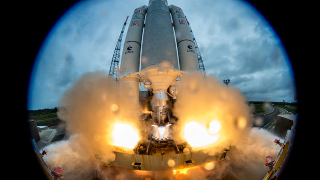
Rewatch the liftoff of Galileo satellites 19–22 by Ariane 5 from Europe's Spaceport in French Guiana on 12 December
Germans’ purchasing power climbs 2.8 percent in 2018
13.12.2017 9:46 GISCafe.com Webcasts-Webinars Bruchsal, Germany, December 12, 2017 – Germans’ 2018 purchasing power will rise to €22,992 per person according to the GfK study …Video: Interview with Erik Hoogerhuis, VP, Sales and Marketing at Cetrus during 2017 Autodesk University Conference
13.12.2017 9:00 GISCafe.com Webcasts-WebinarsDalší inspirace na vánoční dárek
13.12.2017 8:42 GISportal.cz Patříte k těm, kteří dárky nakupují až na poslední chvíli a mají v okolí milovníka map? Letos mu můžete dát dárek, ze kterého bude mít opravdu radost. Před pár dny jsme na Gisportálu inzerovali krásné ...Odborný referent/vrchní referent v oddělení dokumentace KN na Katastrálním pracovišti Hodonín
13.12.2017 6:13 ČÚZK - volná místa Katastrální úřad pro Jihomoravský kraj - Katastrální pracoviště Hodonín vypisuje výběrové řízení na místo Odborný referent/vrchní referent v oddělení dokumentace KN na Katastrálním pracovišti HodonínOdborný referent/vrchní referent v oddělení dokumentace KN na Katastrálním pracovišti Hodonín
13.12.2017 6:13 ČÚZK /Urady/Katastralni-urady/Katastralni-urady/Katastralni-urad-pro-Jihomoravsky-kraj/Uredni-deska/Oznameni-a-jina-uredni-sdeleni/Volna-mista/Odborny-referent-vrchni-referent-v-oddeleni-dokumeOdborný referent/vrchní referent v oddělení dokumentace KN na Katastrálním pracovišti Hodonín
13.12.2017 6:13 ČÚZK - předpisy a opatření Katastrální úřad pro Jihomoravský kraj - Katastrální pracoviště Hodonínvypisuje výběrové řízení na místo
Odborný referent/vrchní referent v oddělení dokumentace KN na Katastrálním pracovišti Hodonín
Princip 3D katastru nemovitostí
13.12.2017 0:24 Zeměměřič Kniha 3D Cadastre – Best Practices vyjde pod hlavičkou FIG na začátku roku 2018. 3D katastr objevuje v nedávno vládou ČR schválené Koncepci zavádění metody BIM v České republice...Galileo: 22 today
12.12.2017 23:43 ESA Navigation
Europe now has 22 Galileo navigation satellites in orbit
Dialog Semiconductor Power Conversion Chipset Used in HUAWEI's Latest Flagship Mate 10 Series
12.12.2017 23:22 GISCafe.com Webcasts-Webinars Charging time and safety enhanced by Dialog's SmartDefender(TM)and other advanced charging technologies
LONDON — (BUSINESS …
Epson Expands its WorkForce Wide-Format Printer Series, Powered by PrecisionCore
12.12.2017 23:22 GISCafe.com Webcasts-Webinars WorkForce Wide-Format Series Delivers High-Volume, Print-Shop-Quality Borderless Prints Up to 13x19 for Small BusinessesLONG BEACH, Calif., Dec. 12, …
AirMap Partners with Airways New Zealand to Trial the Country's First Drone Traffic Management System
12.12.2017 23:22 GISCafe.com Webcasts-Webinars SANTA MONICA, Calif., Dec. 12, 2017 — (PRNewswire) — AirMap has joined forces with Airways New Zealand to deploy an unmanned …Galileo launch brings navigation network close to completion
12.12.2017 23:22 ESA Navigation
Europe has four more Galileo navigation satellites in the sky following their launch on an Ariane 5 rocket. After today’s success, only one more launch remains before the Galileo constellation is complete and delivering global coverage.
Observatoř Herschel objevila spojení galaxií z počátku vesmíru
12.12.2017 23:02 Český Kosmický PortálTo, co se na první pohled zdálo jako vzácný objev rozměrné a staré galaxie, se nakonec ukázalo jako něco ještě vzácnějšího: pár masivních galaxií, který se začal spojovat - a to v okamžiku, kdy byl vesmír starý jen miliardu let.
Comprehensive BIM Strategy Helps Long Jian Road & Bridge Co., Ltd. Deliver CNY 2.4 Billion Amur River Bridge Connecting Russia and China
12.12.2017 21:00 Bentley SystemsPress Coverage
AECCafe, USA
Read the articleSiemens AG's FQ4 boosted by Digital Factory, admiration for Bentley
12.12.2017 20:57 Bentley SystemsPress Coverage
Monica Schnitger, USA
Read the articleBentley's YII 2017 is all about infrastructure, done well
12.12.2017 20:55 Bentley SystemsPress Coverage
Monica Schnitger, USA
Read the articleBP wins award for Khazzan Gas Production project
12.12.2017 20:51 Bentley SystemsPress Coverage
Commercial Construction and Renovation, USA
Read the articleDubai’s Roads and Transport Authority Leverages Common Data Environment to Advance Integrated Transportation for Expo 2020 and Beyond
12.12.2017 20:48 Bentley SystemsPress Coverage
AECCafe, USA
Read the articleA Digital Future for Maintenance
12.12.2017 20:45 Bentley SystemsPress Coverage
Machinery and Equipment MRO and REM, USA
Read the articleNational Grid trial aerial LiDAR inspections for gas network
12.12.2017 20:01 GISCafe.com Webcasts-Webinars Dec 12, 2017 -- National Grid have announced they are conducting a trial programme using laser scanning data to deliver safety and …
Adieu GRACE-FO!
12.12.2017 19:56 GISCafe.com Webcasts-Webinars German-built gravity research satellites are on the way to the launch site atVandenberg Air Force Base in California – launch is planned for …Geomatika a já - videa z roku 2017
12.12.2017 16:30 Blogující geomatici - FAV ZČU
ImageSat International & Terran Orbital announce plan to develop RUNNER™, a high performance, microsatellite to be used in constellation for earth observation and imaging
12.12.2017 16:19 GISCafe.com Webcasts-Webinars Terran Orbital's microsatellite platform redefines the capabilities of satellite imaging. RUNNER utilizes ISI's ground control technology and further …GeoSpark Analytics Launches BlueGlass, a Location-Based, AI-Powered Data Analytics Platform
12.12.2017 16:19 GISCafe.com Webcasts-Webinars BlueGlass is operational at the US Department of Defense, Intelligence Community and a small number of commercial enterprisesCHANTILLY, Va., Dec. …
CoreLogic Reports Mortgage Delinquency Rates Lowest in More Than a Decade
12.12.2017 16:19 GISCafe.com Webcasts-Webinars Overall Mortgage Delinquency Rate Fell 0.2 Percentage Points YearOver Year
Foreclosure Rate Declined 0.2 Percentage …
ATX Seed Ventures leads $3.25 Million Seed Round into Slingshot Aerospace to Use Satellite, Aircraft and Drone Data to Solve Geospatial Information Challenges
12.12.2017 16:18 GISCafe.com Webcasts-Webinars The Austin, Texas-based startup that harnessed satellite data to help save lives during Hurricanes Harvey and Irma, plans to utilize the world's …Prohlížecí služby
12.12.2017 16:00 Středočeský kraj V mapových aplikacích s označením logo JS, a které obsahují nástroj Přidat data logo JS, lze přidávat i služby WMS jiných poskytovatelů. Poskytovateli jsou především orgány státní správy nebo specializované organizační složky. Seznam vybraných služeb uvádí přehledová tabulka v záložce Prohlížecí služby. V současné době lze vybírat z 48 mapových služeb. Tabulka obsahuje také odkazy na webové stránky poskytovatelů.Earth from Space
12.12.2017 14:15 ESA Observing the Earth
Atmospheric scientists from the DLR German Aerospace Center join the Earth from Space video programme to discuss the first data from the recently-launched Sentinel-5P satellite
Vyšel trailer k fulldome dokumentu Jižní Morava pro který jsme více než rok natáčeli speciální technikou letecké záběry
12.12.2017 13:09 UpVision V únoru 2018 bude v Hvězdárna a planetárium Brno premiéra fulldome dokumentu o Jižní Moravě, pro který jsme více než rok natáčeli letecké záběry z dronu se speciální technikou. Stačí se podívat na trailer níže a pohybovat se v něm, abyste poznali, že půjde o něco výjimečného. Už teď se těšíme :-)Brněnská hvězdárna je dlouhodobě průkopníkem v oblasti vlastní tvorby fulldome pořadů v ČR a my se těšíme na další spolupráci.
Trailer zde:
https://www.facebook.com/hvezdarna.brno/videos/10155292662494842/?hc_ref=ARScC6EuAoVmxxPYfDSkU09Sc2UB-X7und5Pa5bub4WhU2rWleSMqo4Th7GNFxRo_CI
UPOZORNĚNÍ !!! - v Geoportálu
12.12.2017 12:00 Ústecký kraj UPOZORNĚNÍ !!! - v Geoportálu ÚAP nebude možný výdej dat 12.12.2017 od 12:30 do 15:00 z důvodu úpravy exportních nástrojů do CAD. Omlouváme se za komplikace.Byl aktualizován vzhled, funkč
12.12.2017 12:00 Plzeňský kraj Byl aktualizován vzhled, funkčnost a tematický obsah mapy zobrazující Zařízení sociálních služeb v Plzeňském kraji (http://mapy.kr-plzensky.cz/gis/socialni_sluzby). V mapě si lze libovolně zobrazovat různé typy a druhy zařízení sociálních služeb. Mapa zobrazuje i obce, v nichž jsou poskytovány pečovatelské služby.Byl aktualizován vzhled, funkč
12.12.2017 12:00 Plzeňský kraj Byl aktualizován vzhled, funkčnost a tematický obsah mapy zobrazující Zařízení sociálních služeb v Plzeňském kraji. V mapě si lze libovolně zobrazovat různé typy a druhy zařízení sociálních služeb. Mapa zobrazuje i obce, v nichž jsou poskytovány pečovatelské služby.Galileos in launch zone
12.12.2017 11:24 ESA Navigation
Galileos 19–22 rolled to their launch zone atop their Ariane 5 launcher during Monday afternoon, ready for today's launch
Přijďte se dozvědět něco nového
12.12.2017 10:10 ARCDATAVyberte si z nabídky našich kurzů a přijďte získat nové znalosti a vědomosti pod vedením zkušených školitelů. Vybírat si můžete z termínů na první pololetí roku 2018.
V nabídce nově naleznete i kurzy Migrace z ArcMap do ArcGIS Pro a ArcGIS Enterprise: nasazení a konfigurace.

Video: Interview with Shimon Elkabetz, CEO, Co-Founder at ClimaCell during 2017 Autodesk University Conference
12.12.2017 9:00 GISCafe.com Webcasts-WebinarsSolv3D names Tammy Peterson as Vice President of Marketing & Sales
12.12.2017 9:00 GISCafe.com Webcasts-Webinars CALGARY – December 12, 2017 – Solv3D Inc., a leading provider of 3D processing, visualization and collaboration tools, announced that …Uživatelská konference Esri v San Diegu (registrace)
12.12.2017 8:38 GISportal.cz Společnost Esri otevřela registraci na jednu z největších konferencí v oboru – uživatelskou konferenci Esri v San Diegu, která se bude konat v termínu 9. – 13. července 2018. Na akci se potkává okolo 18 ...Nabídka ve veřejném zájmu - monitory
12.12.2017 7:00 ČÚZK /Urady/Katastralni-urady/Katastralni-urady/Katastralni-urad-pro-Jihocesky-kraj/Nabidky-majetku/Nabidka-ve-verejnem-zajmu-monitoryNabídka ve veřejném zájmu - monitory
12.12.2017 7:00 ČÚZK - předpisy a opatřeníKatastrální úřad pro Jihočeský kraj nabízí nepotřebný majetek k odkupu. Jedná se o
Nabídka ve veřejném zájmu - monitory
Nejnovější technologie ESA pro družice CubeSat může na start
12.12.2017 2:53 Český Kosmický PortálPočátkem příštího roku bude z Číny vynesena do vesmíru dvojice družic GomX-4A a -4B, což jsou nejnovější a zatím největší satelity třídy CubeSat vzniklé na půdě ESA. Budou testovat mezidružicovou komunikaci a nové způsoby pohonu, zatímco je bude dělit vzdálenost 4500 km.
Observatoř Herschel objevila spojení galaxií z počátku vesmíru
12.12.2017 2:51 Český Kosmický PortálTo, co se na první pohled zdálo jako vzácný objev rozměrné a staré galaxie, se nakonec ukázalo jako něco ještě vzácnějšího: pár masivních galaxií, který se začal spojovat - a to v okamžiku, kdy byl vesmír starý jen miliardu let.
Družice Galileo byly umístěny na raketu a jsou připraveny na start
12.12.2017 2:50 Český Kosmický PortálDalší kvarteto evropských navigačních družic Galileo bylo umístěno na raketu Ariane 5 a nyní je tak vše připraveno na úterní start.
Družice Galileo byly umístěny na raketu a jsou připraveny na start
12.12.2017 2:50 Český Kosmický PortálDalší kvarteto evropských navigačních družic Galileo bylo umístěno na raketu Ariane 5 a nyní je tak vše připraveno na úterní start.
Čtyřicet let s družicemi Meteosat
12.12.2017 2:49 Český Kosmický PortálPrvní družice ESA pro pozorování Země byla vypuštěna 23. listopadu 1977. Když se tento satelit Meteosat dostal na své místo na obloze, dokončil celosvětové pokrytí meteorologickými družicemi z geostacionární oběžné dráhy a položil tak základy evropské a celosvětové spolupráci, která pokračuje až do dnešních dnů.
Pěstování sazeniček ve vesmíru
12.12.2017 2:48 Český Kosmický PortálŽivot na Zemi se potýká s myriádou problémů, ovšem gravitace není jedním z nich: zůstat při zemi znamená, že organismy mohou získávat světlo a teplo, které umožňuje růst.
Družice Sentinel-5P je ve vynikajícím stavu
12.12.2017 2:46 Český Kosmický PortálEvropská družice Sentinel-5P je ve vynikajícím stavu. Jde o první misi programu GMES/Copernius určenou ke sledování stavu vzduchu, který dýcháme. Vypuštěna byla 13. října.
Družice Sentinel-5P je připravena na start
12.12.2017 2:45 Český Kosmický PortálJen několik málo dní nás dělí do startu nové družice řady Sentinel. Ta už je nyní plně připravena na vypouštěcí rampě kosmodromu Pleseck v severním Rusku.
Sledování stravovacích návyků ve vesmíru
12.12.2017 2:43 Český Kosmický PortálAť již jste na dietě nebo se „jen“ snažíte být zdravější, možná jste jedním z těch miliónů lidí na světě, kteří používají mobilní aplikaci pro zaznamenání všeho, co sní. A tento trend nyní dorazil do vesmíru: evropští kosmonauti si nyní zaznamenávají svoji stravu do tabletu. A to proto, aby byla jistota, že dostávají správné množství živin.
Přípravy družice Sentinel-5P na start jsou v plném proudu
12.12.2017 2:42 Český Kosmický PortálStart je plánovaný na 13. října, a tak technici na ruském kosmodromu Pleseck pracují naplno, aby bylo vše připraveno na start další evropské družice systému GMES/Copernicus.
Italské sucho viděné očima družic
12.12.2017 2:41 Český Kosmický PortálNavzdory vítaným srážkám z počátku září přetrvává ve střední Itálii sucho s abnormálně nízkou vlhkostí v půdě. Vědci používají i data z družic, aby zjistili více o stavu, který sužuje celou zemi.
Překvapivé nepravidelné polární záře u planety Jupiter
12.12.2017 2:39 Český Kosmický PortálKosmické teleskopy ESA a NASA zjistily, že na rozdíl od polárních září na Zemi, intenzivní polární záře u pólů planety Jupiter fungují nezávisle jedna na druhé. Jde o neočekávané chování.
Dobrodružství Paola Nespoliho s robotem Justin
12.12.2017 2:38 Český Kosmický PortálV srpnu řídil kosmonaut ESA Paolo Nespoli rover umístěný v Německu - ač sám byl na Mezinárodní kosmické stanici. Šlo o část projektu ESA METERON, který byl prováděný s robotem německé letecko-kosmické agentury DLR s přezdívkou Rollin’ Justin. Jeho cílem je vyvinout způsoby, které by umožnily kosmonautům řídit roboty z oběžné dráhy.
Filtry frekvencí vyrobené 3D tiskem pomáhají telekomunikačním družicím
12.12.2017 2:36 Český Kosmický PortálVyužití 3D tisku by mělo pomoci vytvářet výkonnější telekomunikační družice. Už prototypová výroba radiofrekvenčních filtrů slibuje vyšší výkon při nižší ceně a hmotnosti.
Generátor atomárního kyslíku vytváří to, co na Zemi nemáme
12.12.2017 2:35 Český Kosmický PortálESA zprovoznila nový simulátor, který využívá laser ke generování druhu kyslíku, s nímž se lze běžně setkat jen na nízkých oběžných drahách. A o němž je známo, že „požírá“ povrch družic.
Systémy pro přistání (nejen) na asteroidech jsou zkoušeny speciálním softwarem
12.12.2017 2:33 Český Kosmický PortálNa obrazovce se krátery posetá neznámá krajina čím dál více blíží - a tím techniky přistání na asteroidu nebo planetě dostávají na nejrealističtější možnou simulaci a jsou velmi blízké skutečnému letu. Nová generace supervýkonného software dovoluje testování přistávacích algoritmů a hardware v reálném čase.
Konstrukce CubeSatů vyrobené 3D tiskem umožní levnější a rychlejší mise
12.12.2017 2:31 Český Kosmický PortálCoby první test nového tvrdého a elektricky vodivého plastu vyrobila ESA 3D tiskem konstrukce družic CubeSat, a to včetně elektroinstalace. V budoucnu mohou být takovéto miniaturizované družice připraveny k práci bezprostředně poté, co budou osazeny přístroji, elektrickými obvody a panely slunečních baterií.
Kontrakt pozvedá systém EGNOS na vyšší úroveň
12.12.2017 2:30 Český Kosmický PortálESA podepsala kontrakt s firmou Thales Alenia Space na modernizaci evropské infrastruktury EGNOS pro zpřesňování družicových navigačních systémů. Jde o další potvrzení kritické důležitosti satelitní navigace na starém kontinentu.
První mise SmallGEO začala sloužit
12.12.2017 2:29 Český Kosmický PortálPo čtyřech měsících intenzivního testování ve vesmíru prošla vlajková mise SmallGEO Hispasat 36W-1 všemi zkouškami, v nichž dostala pomyslnou „zelenou“. Což znamená, že řízení mise bylo možné předat operátorovi.
Sonda LISA Pathfinder začala provádět technické experimenty
12.12.2017 2:27 Český Kosmický PortálPoslední dny mise Pathfinder patří k těm rušnějším, protože řídicí středisko provádí finální testy a připravuje se vypnout průkopnickou gravitační sondu.
Družice Sentinel zachytily zrození obřího ledovce
12.12.2017 2:26 Český Kosmický PortálBěhem několika posledních měsíců se kus ledovce Larsen C v Antarktidě ocitnul na pomyslném vlásku, když se objevila hluboká a dlouhá trhlina v ledu. Jak zaznamenala družice GMES/Copernicus Sentinel-1, kus ledu srovnatelný svou velikostí s krajem Vysočina se nyní odtrhl. Tím vznikl jeden z největších ledovců v historii a tím se také navždy změnil tvar Antarktického poloostrova.
První snímky z družice Sentinel-2B předané laserem
12.12.2017 2:25 Český Kosmický PortálS tím, jak se přiblížil začátek operačního provozu družce Sentinel-2B, tak se tento nejnovější přírůstek systému GMES/Copernicus spojil s komunikační družicí Alphasat, a to pomocí laseru na vzdálenost téměř 36 tisíc kilometrů. Snímky Země byly tímto způsobem předané do pozemního střediska jen okamžik poté, co vznikly.
Jak zachránit kosmonauta v nouzi během lunární procházky?
12.12.2017 2:23 Český Kosmický PortálBěhem simulované mise do dalekého vesmíru, která proběhla na počátku července, testovala ESA nový koncept, s jehož pomocí lze dostat zpět kosmonauty na základnu, i když se stanou během lunárního průzkumu návratu neschopní.
Umělý mozek pomáhá misi Gaia odhalit rychle se pohybující hvězdy
12.12.2017 2:22 Český Kosmický PortálS pomocí software, který napodobuje lidský mozek, nalezla družice ESA Gaia šest hvězd pohybujících se vysokou rychlostí z centra naší galaxie k jejímu okraji. To nám může pomoci získat klíčové informace o některých dosud tajemstvím obestřených oblastech Mléčné dráhy.
Budoucnost souhvězdí Orion
12.12.2017 2:20 Český Kosmický PortálNové video založené na měřeních družic ESA Gaia a Hipparcos ukazuje, jak by se měl proměnit náš pohled na souhvězdí Orion v následujících 450 tisících letech.
Staré rukopisné geologické mapy 1 : 28 800
12.12.2017 1:00 Cenia - Katalog metadat ČR - INSPIRE Rukopisné geologické mapy z druhé poloviny 19. století v měřítku 1 : 28 800 byly vyhotoveny na podkladu II. vojenského mapování území Čech, Moravy a Slezska. Na mapovém serveru ČGS jsou publikovány se svolením archivu Rakouské geologické služby (GBA). K dispozici je název mapového listu v češtině a němčině, dále informace o autorovi a roku vzniku mapy (pokud jsou známy), odkaz na soubor s geologickou legendou (pokud je k dispozici) a odkazy do mapových archivů ČGS a GBA.Historie geologického mapování území ČR
12.12.2017 1:00 Cenia - Katalog metadat ČR - INSPIRE Aplikace mapového serveru zobrazuje dva soubory starých geologických map z území Čech a Moravy - jednak rukopisné geologické mapy v měřítku 1 : 28 800, a jednak tištěné geologické mapy v měřítku 1 : 144 000 (tzv. Haidingerovy). Uživatel má možnost si zobrazit dostupné informace k jednotlivým mapovým listům. K rukopisným mapám je to název mapového listu v češtině a němčině, dále informace o autorovi a roku vzniku mapy (pokud jsou známy), odkaz na soubor s geologickou legendou (pokud je k dispozici) a odkazy do mapových archivů ČGS a GBA. K tištěným mapám potom název mapového listu, jméno autora a odkaz do mapového archivu ČGS.Na mapovém serveru ČGS jsou rukopisné mapy publikovány se svolením archivu Rakouské geologické služby (GBA).Staré rukopisné geologické mapy 1 : 28 800
12.12.2017 1:00 Cenia - Katalog metadat ČR - INSPIRE ArcGIS Server mapová služba pro zpřístupnění starých rukopisných geologických map v měřítku 1 : 28 800 z území ČR.Geomni Capturing Aerial Imagery of California Wildfires
12.12.2017 0:52 GISCafe.com Webcasts-Webinars Lehi, Utah, December 11, 2017 — Last week, Geomni activated one of its regional hubs and is proactively capturing aerial imagery in response to …Prominent Industry Leaders Join Deveron UAS Advisory Board
11.12.2017 18:32 GISCafe.com Webcasts-Webinars TORONTO, ONTARIO -- (Marketwired) -- Dec 11, 2017 --Deveron UAS Corp. (CSE: DVR)(CSE: DVR.CN)(CNSX: DVR) ("Deveron" or the "Company"), is pleased …
SSL to provide access to space for small satellite constellation
11.12.2017 18:32 GISCafe.com Webcasts-Webinars PALO ALTO, CA, Dec. 11, 2017 — (PRNewswire) — SSL, a business unit of Maxar Technologies (formerly MacDonald, Dettwiler and …Esri Technology Will Help Power the United Nations' New Global Data Hub
11.12.2017 18:32 GISCafe.com Webcasts-Webinars Software Platform Provides Geographic Insights into ReportingProgress for the Sustainable Development Goals
REDLANDS, …
Referent společných správních činností
11.12.2017 17:08 ČÚZK /Urady/Zememericky-urad/Uredni-deska/Oznameni-a-jina-uredni-sdeleni/Volna-mista/Referent-spolecnych-spravnich-cinnosti-(1)Referent společných správních činností
11.12.2017 17:08 ČÚZK - volná místa Zeměměřický úřad vypisuje výběrové řízení na místo Referent společných správních činnostíReferent společných správních činností
11.12.2017 17:08 Zeměměřický úřad Zeměměřický úřadvypisuje výběrové řízení na místo
Referent společných správních činností
Referent společných správních činností
11.12.2017 17:08 ČÚZK - předpisy a opatření Zeměměřický úřadvypisuje výběrové řízení na místo
Referent společných správních činností
Ředitel Odboru hospodářské správy
11.12.2017 17:06 ČÚZK /Urady/Zememericky-urad/Uredni-deska/Oznameni-a-jina-uredni-sdeleni/Volna-mista/Reditel-odboru-hospodarske-spravy-(1)Ředitel Odboru hospodářské správy
11.12.2017 17:06 ČÚZK - volná místa Zeměměřický úřad vypisuje výběrové řízení na místo Ředitel Odboru hospodářské správyŘeditel Odboru hospodářské správy
11.12.2017 17:06 Zeměměřický úřad Zeměměřický úřadvypisuje výběrové řízení na místo
Ředitel Odboru hospodářské správy
Ředitel Odboru hospodářské správy
11.12.2017 17:06 ČÚZK - předpisy a opatření Zeměměřický úřadvypisuje výběrové řízení na místo
Ředitel Odboru hospodářské správy
CO2 and oceans
11.12.2017 16:30 ESA Observing the Earth
Discover how satellites can help us understand the role of oceans in regulating carbon dioxide – the most import human-made greenhouse gas responsible for global warming
ProStructures CONNECT Edition Delivers Parametric Structural Components to Drive Greater Productivity
11.12.2017 16:00 Bentley SystemsPress Coverage
AECCafe, USA
Read the articleBentley's Year in Infrastructure 2017 Conference
11.12.2017 15:52 Bentley SystemsPress Coverage
AECbytes, USA
Read the articleImproved Efficiency, Integration, and Management of Information Lays the Foundation for Digital Railway Assets in China
11.12.2017 15:47 Bentley SystemsPress Coverage
AECCafe, USA
Read the articleBIM Advancement in Reality Modeling
11.12.2017 15:39 Bentley SystemsPress Coverage
Civil + Structural Engineering, USA
Read the articleGoing Digital: The Year in Infrastructure
11.12.2017 15:33 Bentley SystemsPress Coverage
Civil + Structural Engineering, USA
Read the articleGeometric Innovation for Iconic 1 Blackfriars London Inspires the Next Generation of Designers
11.12.2017 15:26 Bentley SystemsPress Coverage
AECCafe, USA
Read the articleMapová aplikace Investiční příležitosti
11.12.2017 15:00 Středočeský kraj Mapová aplikace Vybrané investiční příležitosti ve Středočeském kraji byla upravena do nové podoby. Kromě nového vzhledu aplikace nabízí uživateli především jednoduchou a rychlou možnost zobrazovat u zájmové lokality tzv. identifikační kartu, dokument PDF prezentující předmětné území. Jednotlivé lokality se nově odkazují i na Google Street View a Google Mapy. Uživatel si nadále může měnit podkladovou mapu za ortofotomapu nebo za mapu Ochrany přírody a krajiny anebo nově za hlavní výkresy Územních plánů. Identifikační karty jsou nově k dispozici i v Angličtině a v Němčině. Aplikace se zobrazuje také v mobilních zařízeních a je v ní možné zapnout i aktuální polohu. Nová podoba mapová aplikace Investiční příležitosti je jednou z dalších cest, jak jednoduše a přehledně prezentovat prostorová data Krajského úřadu Středočeského kraje směrem k laické a odborné veřejnosti.Odborný referent v oddělení obnovy katastrálního operátu technického útvaru (03010) Katastrálního úř
11.12.2017 14:02 ČÚZK - volná místa Katastrální úřad pro Královéhradecký kraj vypisuje výběrové řízení na místo Odborný referent v oddělení obnovy katastrálního operátu technického útvaru (03010) Katastrálního úřOdborný referent v oddělení obnovy katastrálního operátu technického útvaru (03010) Katastrálního úř
11.12.2017 14:02 ČÚZK /Urady/Katastralni-urady/Katastralni-urady/Katastralni-urad-pro-Kralovehradecky-kraj/Volna-mista/Odborny-referent-v-oddeleni-obnovy-katastralniho-oOdborný referent v oddělení obnovy katastrálního operátu technického útvaru (03010) Katastrálního úř
11.12.2017 14:02 ČÚZK - předpisy a opatření Katastrální úřad pro Královéhradecký krajvypisuje výběrové řízení na místo
Odborný referent v oddělení obnovy katastrálního operátu technického útvaru (03010) Katastrálního úřadu pro Královéhradecký kraj
Odborný referent/vrchní referent v oddělení aktualizace katastru nemovitostí Katastrálního pracovišt
11.12.2017 13:56 ČÚZK - volná místa Katastrální úřad pro Královéhradecký kraj - Katastrální pracoviště Hradec Králové vypisuje výběrové řízení na místo Odborný referent/vrchní referent v oddělení aktualizace katastru nemovitostí Katastrálního pracovištOdborný referent/vrchní referent v oddělení aktualizace katastru nemovitostí Katastrálního pracovišt
11.12.2017 13:56 ČÚZK /Urady/Katastralni-urady/Katastralni-urady/Katastralni-urad-pro-Kralovehradecky-kraj/Uredni-deska/Oznameni-a-jina-uredni-sdeleni/Volna-mista/Odborny-referent-vrchni-referent-v-oddeleni-aktualOdborný referent/vrchní referent v oddělení aktualizace katastru nemovitostí Katastrálního pracovišt
11.12.2017 13:56 ČÚZK - předpisy a opatření Katastrální úřad pro Královéhradecký kraj - Katastrální pracoviště Hradec Královévypisuje výběrové řízení na místo
Odborný referent/vrchní referent v oddělení aktualizace katastru nemovitostí Katastrálního pracoviště Hradec Králové
Hledáte něco? Najděte si vše pohodlně sami
11.12.2017 13:47 Zeměměřič Redakce Zeměměřiče dostává dotazy, kdy něco hledáte a jen víte, že to vyšlo před časem v Zeměměřiči. Ve volnějších chvilkách jsme začali vytvářet kompletní ročníky Zeměměřiče, kdy bude vždy 6 čísel z příslušného roku umístěno v jednom souboru na Alza.cz, a vy tam můžete normálně vyhledávat pomocí řetězce znaků.Konec roku je dobrou příležitostí do těchto souborů investovat a pomoci sobě i redakci Zeměměřiče. Předem děkujeme.
3D model lebky vyhynulého živočicha Megatherium [Katedra aplikované geoinformatiky a kartografie, byTopic]
11.12.2017 13:20 Katedra aplikované geoinformatiky a kartografie Přf UK Jak lze využít geoinformační metody pro dokumentaci paleontologických ostatků a tvorbu jejich 3D modelů? Odpověď na tuto otázku hledal v rámci bakalářské práce řešené na katedře aplikované geoinformatiky a kartografie Marek Čelonk.Práce ukazuje praktickou aplikaci moderní metody laserového skenování a tradiční průsekové fotogrammetrie pro tvorbu 3D modelu lebky vyhynulého živočicha Megatherium.
Mapová aplikace byla doplněna
11.12.2017 12:00 Jihočeský kraj Mapová aplikace byla doplněna o pětileté průměry z let 2012-2016.Pro větší přehlednost při výde
11.12.2017 12:00 Jihočeský kraj Pro větší přehlednost při výdeji dat do CAD formátů (DGN, DWG a DXF) se nově název hladiny skládá z EntitaID_Název jevu_StavID.Mapová aplikace Znečištění ovz
11.12.2017 12:00 Jihočeský kraj Mapová aplikace Znečištění ovzduší byla doplněna o pětileté průměry z let 2012-2016.rada / odborný rada v oddělení aktualizace katastru nemovitostí Katastrálního pracoviště Pardubice
11.12.2017 11:23 ČÚZK - volná místa Katastrální úřad pro Pardubický kraj - Katastrální pracoviště Pardubice vypisuje výběrové řízení na místo rada / odborný rada v oddělení aktualizace katastru nemovitostí Katastrálního pracoviště Pardubicerada / odborný rada v oddělení aktualizace katastru nemovitostí Katastrálního pracoviště Pardubice
11.12.2017 11:23 ČÚZK /Urady/Katastralni-urady/Katastralni-urady/Katastralni-urad-pro-Pardubicky-kraj/Uredni-deska/Oznameni-a-jina-uredni-sdeleni/Volna-mista/rada-odborny-rada-v-oddeleni-aktualizace-katastrrada / odborný rada v oddělení aktualizace katastru nemovitostí Katastrálního pracoviště Pardubice
11.12.2017 11:23 ČÚZK - předpisy a opatření Katastrální úřad pro Pardubický kraj - Katastrální pracoviště Pardubicevypisuje výběrové řízení na místo
rada / odborný rada v oddělení aktualizace katastru nemovitostí Katastrálního pracoviště Pardubice
Na semináři Gate2Space jsme představili vítězný projekt v ESNC 2017
11.12.2017 10:50 UpVision Včera jsme měli přednášku o možnostech využití dronů pro identifikaci zvěře při sklizních na semináři Gate2Space v Technologickém centru AV ČR.Více o akci zde:
http://www.czechspaceportal.cz/7-sekce/kalendar-akci/save-the-date-gate2space-2017.html
Automechanik
11.12.2017 10:46 Zeměměřický úřad Zeměměřický úřadvypisuje výběrové řízení na místo
Automechanik
Automechanik
11.12.2017 10:46 ČÚZK - volná místa Zeměměřický úřad vypisuje výběrové řízení na místo AutomechanikAutomechanik
11.12.2017 10:46 ČÚZK - předpisy a opatření Zeměměřický úřadvypisuje výběrové řízení na místo
Automechanik