


![]()

zprávy
zdroje zpráv:Nepotřebný majetek - různé
8.6.2017 13:48 ČÚZK /Urady/Katastralni-urady/Katastralni-urady/Katastralni-urad-pro-Liberecky-kraj/Nabidky-majetku/Nepotrebny-majetek-ruzne-(1)Nepotřebný majetek - různé
8.6.2017 13:48 ČÚZK - předpisy a opatřeníKatastrální úřad pro Liberecký kraj nabízí nepotřebný majetek k odkupu. Jedná se o
Nepotřebný majetek - různé
Nepotřebný majetek - různé
8.6.2017 13:48 ČÚZK - předpisy a opatřeníKatastrální úřad pro Liberecký kraj nabízí nepotřebný majetek k odkupu. Jedná se o
Nepotřebný majetek - různé
Okno do mokré minulosti planety Mars
8.6.2017 12:48 Český Kosmický PortálTento kráter o průměru 70 kilometrů a jeho bezprostřední okolí nabízí unikátní pohled do mokré minulosti Rudé planety.
Okno do mokré minulosti planety Mars
8.6.2017 12:48 Český Kosmický PortálTento kráter o průměru 70 kilometrů a jeho bezprostřední okolí nabízí unikátní pohled do mokré minulosti Rudé planety.
V části Zajímavé stránky (http
8.6.2017 12:00 Plzeňský kraj V části Zajímavé stránky (http://geoportal.plzensky-kraj.cz/gs/zajimave-stranky/) byl doplněn odkaz na Mapu exekucí (http://mapaexekuci.cz/) a odkaz na Genderovou mapu (http://www.genderovamapa.cz/).Z důvodu nasazování nového výd
8.6.2017 12:00 Ústecký kraj Z důvodu nasazování nového výdejního modulu budou prováděny úpravy na mapových serverech. V souvislosti s tímto může docházet k výpadkům mapových služeb a nástrojů na Geoportálu ÚK (jako je výdej a nahrávání dat). Proto žádáme, aby si registrovaní uživatelé do odvolání nežádali o data z GP a ani je nenahrávali. Děkujeme za pochopení.V části Zajímavé stránky byl d
8.6.2017 12:00 Plzeňský kraj V části Zajímavé stránky byl doplněn odkaz na Mapu exekucí, odkaz na Genderovou mapu a odkaz na Stromy pod kontrolou.V části Zajímavé stránky (http
8.6.2017 12:00 Plzeňský kraj V části Zajímavé stránky (http://geoportal.plzensky-kraj.cz/gs/zajimave-stranky/) byl doplněn odkaz na Mapu exekucí (http://mapaexekuci.cz/), odkaz na Genderovou mapu (http://www.genderovamapa.cz/) a odkaz na Stromy pod kontrolou (http://www.stromypodkontrolou.cz/).V datech územně analytických p
8.6.2017 12:00 Plzeňský kraj V datech územně analytických podkladů Plzeňského kraje byla provedena aktualizace dat o Půdních blocích a Ekologicky významných prvcích z dat LPIS od poskytovatele Ministerstvo zemědělství. Jedná se o aktualizaci volně dostupných dat z platností k 1. 6. 2017.V datech územně analytických p
8.6.2017 12:00 Plzeňský kraj V datech územně analytických podkladů Plzeňského kraje byla provedena aktualizace dat o Půdních blocích a Ekologicky významných prvcích z dat LPIS od poskytovatele Ministerstvo zemědělství (http://geoportal.plzensky-kraj.cz/gs/rss?url=http%3A%2F%2Fgeoportal.plzensky-kraj.cz%2Ftw%2Fost%2Fgp%2Fuap%2Fposkytovatele%2Findex.php%3Fframe%26ID%3D544). Jedná se o aktualizaci volně dostupných dat z platností k 1. 6. 2017.Rada/odborný rada v právním oddělení č. 1
8.6.2017 11:03 ČÚZK - předpisy a opatření Katastrální úřad pro Jihomoravský kraj Katastrální pracoviště Brno-městonabízí služební místo
Rada/odborný rada v právním oddělení č. 1
Rada/odborný rada v právním oddělení č. 1
8.6.2017 11:03 ČÚZK - volná místa Katastrální úřad pro Jihomoravský kraj, Katastrální pracoviště Brno-město vypisuje výběrové řízení na místo Rada/odborný rada v právním oddělení č. 1Rada/odborný rada v právním oddělení č. 1
8.6.2017 11:03 ČÚZK - předpisy a opatření Katastrální úřad pro Jihomoravský kraj Katastrální pracoviště Brno-městonabízí služební místo
Rada/odborný rada v právním oddělení č. 1
Rada/odborný rada v právním oddělení č. 1
8.6.2017 11:03 ČÚZK /Urady/Katastralni-urady/Katastralni-urady/Katastralni-urad-pro-Jihomoravsky-kraj/Volna-mista/Rada-odborny-rada-v-pravnim-oddeleni-c-1Eye on oceans
8.6.2017 11:00 ESA Observing the Earth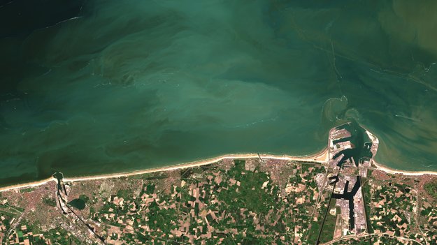
Every year, 8 June marks World Oceans Day. Satellites continue to monitor our water bodies to help us better understand and protect these natural resources
Galileo grows: two more satellites join working constellation
8.6.2017 10:42 ESA Navigation
Two further satellites have formally become part of Europe’s Galileo satnav system, broadcasting timing and navigation signals worldwide while also picking up distress calls across the planet.
Near-shore phytoplankton bloom captured from space
8.6.2017 10:28 ESA Observing the Earth
Last year, the Sentinel-2A satellite captured an intense algal bloom very close to the Belgian coast. The high-resolution capabilities of Sentinel-2’s main instrument are allowing scientists to monitor algae blooms in areas previously not possible to observe with satellites.
Mapová kompozice - ZABAGED® - WMTS
8.6.2017 2:00 Cenia - Katalog metadat ČR - INSPIRE Mapová kompozice WMC - ZABAGED® - WMTS je poskytována jako veřejná mapová aplikace nad daty ZABAGED®. Kompozice je sestavena pro prohlížení v klientu prohlížecích služeb Geoprohlížeč ČÚZK, kde lze tyto poskytovatelem přednastavené kompozice měnit pomocí funkce Změnit mapu. Základem je prohlížecí služba WMTS - ZABAGED® - stav k 25. 12. 2016, která je doplněna o další obsah pomocí těchto služeb: WMS - ZABAGED® (Výškopis-vrstevnice), WMS - Geonames, WMS - Klady mapových listů, WMS - Geografická síť WGS84, WMS - Stínovaný model reliéfu.Obsažené služby splňují technické pokyny pro INSPIRE prohlížecí služby v. 3.1 a zároveň splňují standard OGC WMS 1.1.1. a 1.3.0.Check Out Our Precision 3D Webinar Series – Being Held This June Only
8.6.2017 0:05 Carlson Software For the rest of June, webinars will be hosted on Precision 3D Topo. Check the times below and register as an attendee. About Precision 3D Topo It’s all new from Carlson — Carlson Precision 3D Topo, a drag and drop software that enables much faster design and analysis in the 3D environment than the many […]Check Out Our Precision 3D Webinar Series – Being Held This June Only
8.6.2017 0:05 Carlson Software For the rest of June, webinars will be hosted on Precision 3D Topo. Check the times below and register as an attendee. About Precision 3D Topo It’s all new from Carlson — Carlson Precision 3D Topo, a drag and drop software that enables much faster design and analysis in the 3D environment than the many […]Check Out Our Precision 3D Webinar Series – Being Held This June Only
8.6.2017 0:05 Carlson Software For the rest of June, webinars will be hosted on Precision 3D Topo. Check the times below and register as an attendee. About Precision 3D Topo It’s all new from Carlson — Carlson P3D, a drag and drop software that enables much faster design and analysis in the 3D environment than the many step processes […]Oznámení o přerušení provozu na Pobočce Vsetín
8.6.2017 0:00 Státní pozemkový úřad Z důvodu plánovaného přerušení dodávky elektrické energie bude ve čtvrtek 22. 6. 2017 přerušen provoz na Pobočce Vsetín (KPÚ pro Zlínský kraj).Společnost CEDA spustila webové mapové služby CWS verze 2
7.6.2017 15:30 CEDA Maps a.s. Praha, 7. června 2017 – Společnost Central European Data Agency, a. s., oznamuje spuštění nové verze služby CEDA Web Services (CWS) ve verzi 2 s řadou nových a vylepšených funkcí.Megarozhovor s Jiřím Bradáčem v časopise Zeměměřič
7.6.2017 13:53 T-MAPYThe post Megarozhovor s Jiřím Bradáčem v časopise Zeměměřič appeared first on T-MAPY spol. s r.o..
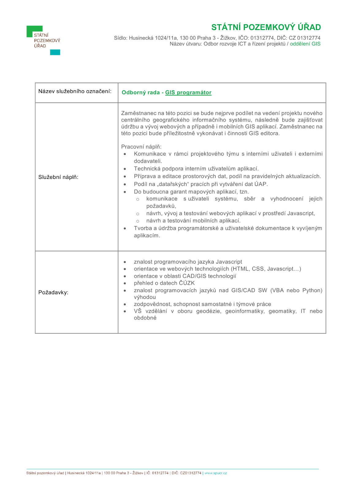
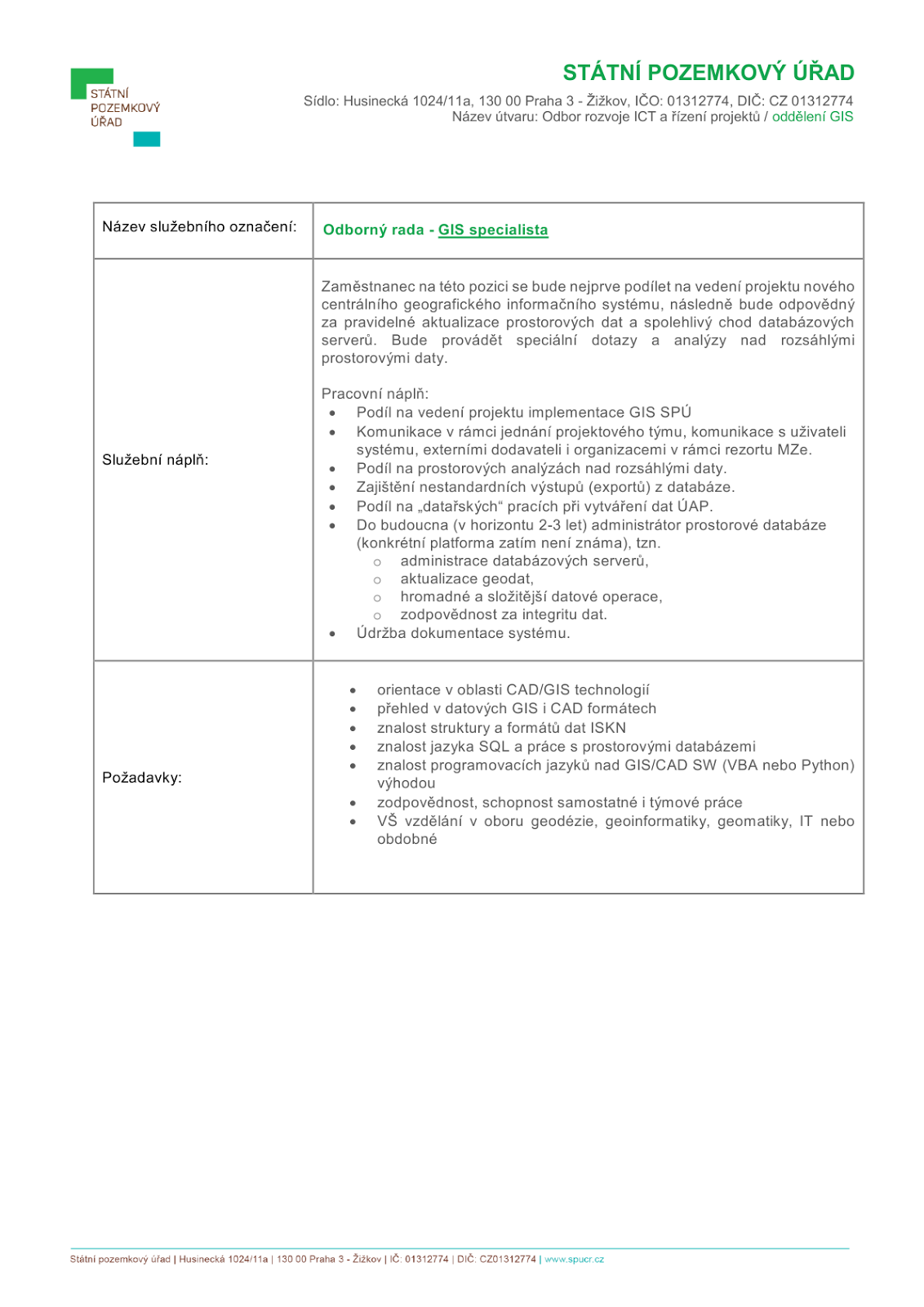
Státní pozemkový úřad vypisuje 2 služební místa na pozice v oddělení GIS
7.6.2017 13:19 Blogující geomatici - FAV ZČU
V sekci Zásady územního rozvoj
7.6.2017 12:00 Jihočeský kraj V sekci Zásady územního rozvoje - 6. aktualizace ZÚR Jihočeského kraje je zveřejněn návrh 6. aktualizace Zásad územního rozvoje Jihočeského kraje pro společné jednání.V sekci Zásady územního rozvoj
7.6.2017 12:00 Jihočeský kraj V sekci Zásady územního rozvoje - 6. aktualizace ZÚR Jihočeského kraje (http://geoportal.kraj-jihocesky.gov.cz/gs/6-aktualizace-zur/) je zveřejněn20170607-Rada/odborný rada oddělení aktualizace a dokumentace
7.6.2017 9:39 ČÚZK - předpisy a opatření Na úřední elektronické desce Katastrálního úřadu pro Středočeský kraj, v sekci "Oznámení a jiná úřední sdělení" bylo vystaveno "Oznámení o vyhlášení výběrového řízení na služební místo Rada/odborný rada oddělení aktualizace a dokumentace"20170607-Odborný rada právního odděle
7.6.2017 9:39 ČÚZK - předpisy a opatření Na úřední elektronické desce Katastrálního úřadu pro Středočeský kraj, v sekci "Oznámení a jiná úřední sdělení" bylo vystaveno "Oznámení o vyhlášení výběrového řízení na služební místo Rada/odborný rada oddělení aktualizace a dokumentace"20170607-Rada/odborný rada oddělení aktualizace a dokumentace
7.6.2017 9:39 ČÚZK - předpisy a opatření zveřejnil novou aktualitu: Na úřední elektronické desce Katastrálního úřadu pro Středočeský kraj, v sekci "Oznámení a jiná úřední sdělení" bylo vystaveno "Oznámení o vyhlášení výběrového řízení na služební místo Rada/odborný rada oddělení aktualizace a dokumentace"20170607-Rada/odborný rada oddělení aktualizace a dokumentace
7.6.2017 9:39 ČÚZK /Urady/Katastralni-urady/Katastralni-urady/Katastralni-urad-pro-Stredocesky-kraj/Katastralni-pracoviste/KP-Nymburk/O-uradu/Aktuality/20140318-Geodet-Melnik-(6)Rada/odborný rada oddělení aktualizace a dokumentace
7.6.2017 9:38 ČÚZK /Urady/Katastralni-urady/Katastralni-urady/Katastralni-urad-pro-Stredocesky-kraj/Uredni-deska/Oznameni-a-jina-uredni-sdeleni/Volna-mista/Rada-odborny-rada-oddeleni-aktualizace-a-dokumentaRada/odborný rada oddělení aktualizace a dokumentace
7.6.2017 9:38 ČÚZK - volná místa Katastrální úřad pro Středočeský kraj, Katastrální pracoviště Nymburk vypisuje výběrové řízení na místo Rada/odborný rada oddělení aktualizace a dokumentaceRada/odborný rada oddělení aktualizace a dokumentace
7.6.2017 9:38 ČÚZK - předpisy a opatření Katastrální úřad pro Středočeský kraj Katastrální pracoviště Nymburkvypisuje výběrové řízení na místo Rada/odborný rada oddělení aktualizace a dokumentace
Rada/odborný rada oddělení aktualizace a dokumentace
Rada/odborný rada oddělení aktualizace a dokumentace
7.6.2017 9:38 ČÚZK - předpisy a opatření Katastrální úřad pro Středočeský kraj Katastrální pracoviště Nymburkvypisuje výběrové řízení na místo Rada/odborný rada oddělení aktualizace a dokumentace
Rada/odborný rada oddělení aktualizace a dokumentace
Omezení provozu Katastrálního pracoviště 16.6.2017
7.6.2017 9:23 ČÚZK /Urady/Katastralni-urady/Katastralni-urady/Katastralni-urad-pro-Stredocesky-kraj/Katastralni-pracoviste/KP-Mlada-Boleslav/O-uradu/Aktuality/Omezeni-provozu-Katastralniho-pracoviste-16-6-2017Omezení provozu Katastrálního pracoviště 16.6.2017
7.6.2017 9:23 ČÚZK - předpisy a opatření zveřejnil novou aktualitu: DŮLEŽITÉ UPOZORNĚNÍVážení klienti,
v pátek 16. června 2017 dojde mimořádně k ukončení provozu Katastrálního pracoviště Mladá Boleslav již v 11:00 hodin. Důvodem je plánovaná instalace nové verze informačního systému katastru nemovitostí.
Děkujeme za pochopení.
Omezení provozu Katastrálního pracoviště 16.6.2017
7.6.2017 9:23 ČÚZK - předpisy a opatření DŮLEŽITÉ UPOZORNĚNÍVážení klienti,
v pátek 16. června 2017 dojde mimořádně k ukončení provozu Katastrálního pracoviště Mladá Boleslav již v 11:00 hodin. Důvodem je plánovaná instalace nové verze informačního systému katastru nemovitostí.
Děkujeme za pochopení.
Mimořádné ukončení provozu 16.6.2017 již v 11:00
7.6.2017 9:15 ČÚZK - předpisy a opatření zveřejnil novou aktualitu:V pátek 16. června 2017 dojde mimořádně k ukončení provozu Katastrálního úřadu pro Středočeský kraj již v 11:00 hodin. Důvodem je plánovaná instalace nové verze informačního systému katastru nemovitostí.
Děkujeme za pochopení.
Mimořádné ukončení provozu 16.6.2017 již v 11:00
7.6.2017 9:15 ČÚZK /Urady/Katastralni-urady/Katastralni-urady/Katastralni-urad-pro-Stredocesky-kraj/Katastralni-pracoviste/KP-Benesov/O-uradu/Aktuality/Mimoradne-ukonceni-provozu-16-6-2017-jiz-v-11-00Mimořádné ukončení provozu 16.6.2017 již v 11:00
7.6.2017 9:15 ČÚZK - předpisy a opatřeníV pátek 16. června 2017 dojde mimořádně k ukončení provozu Katastrálního úřadu pro Středočeský kraj již v 11:00 hodin. Důvodem je plánovaná instalace nové verze informačního systému katastru nemovitostí.
Děkujeme za pochopení.
Přerušení dodávky elektřiny 9.6.2017
7.6.2017 9:01 ČÚZK /Urady/Katastralni-urady/Katastralni-urady/Katastralni-urad-pro-Stredocesky-kraj/Katastralni-pracoviste/KP-Benesov/O-uradu/Aktuality/Preruseni-dodavky-elektriny-9-6-2017Přerušení dodávky elektřiny 9.6.2017
7.6.2017 9:01 ČÚZK - předpisy a opatření
Důležité upozornění
Vážení klienti,
V pátek 9. června 2017 nebude celý den zajištěn provoz Katastrálního pracoviště Benešov. Důvodem je plánované přerušení dodávky elektřiny.
Děkujeme za pochopení.
Odstávka
7.6.2017 9:01 ČÚZK - předpisy a opatření DŮLEŽITÉ UPOZORNĚNÍVážení klienti,
V pátek 16. června 2017 dojde mimořádně k ukončení provozu Katastrálního pracoviště Kladno již v 11:00 hodin. Důvodem je plánovaná instalace nové verze informačního systému katastru nemovitostí.
Děkujeme za pochopení.
Odstávka
7.6.2017 9:01 ČÚZK - předpisy a opatření zveřejnil novou aktualitu: DŮLEŽITÉ UPOZORNĚNÍVážení klienti,
V pátek 16. června 2017 dojde mimořádně k ukončení provozu Katastrálního pracoviště Kladno již v 11:00 hodin. Důvodem je plánovaná instalace nové verze informačního systému katastru nemovitostí.
Děkujeme za pochopení.
Odstávka
7.6.2017 9:01 ČÚZK /Urady/Katastralni-urady/Katastralni-urady/Katastralni-urad-pro-Stredocesky-kraj/Katastralni-pracoviste/KP-Kladno/O-uradu/Aktuality/OdstavkaBlíží se uzávěrka Student GIS Projektu
7.6.2017 8:34 GISportal.cz Uzávěrka přihlášek do soutěže Student GIS Projekt 2017 je stanovena již na 15. června 2017. Tato soutěž je určena všem studentům, kteří letos nebo vloni v rámci svých bakalářských, diplomových a disertačních prací využili software Esri ...Vystavovali jsme minulý týden na Dronfestu 2017 v Plzni
7.6.2017 8:23 UpVision Opět po roce jste nás mohli potkat na našem stánku na DronFest 2017 v Plzni, který se moc povedl. Ukázali jsme také poprvé prototyp trackeru pro naší mobilní aplikaci MAIA.Děkujeme Drony SITMP a budeme se těšit zase za rok. :-)
Fotky z akce zde:
https://plus.google.com/+UpvisionCz1/posts/UYQWBReJjkQ
DŮLEŽITÉ UPOZORNĚNÍ
7.6.2017 7:52 ČÚZK - předpisy a opatření DŮLEŽITÉ UPOZORNĚNÍVážení klienti,
V pátek 16.června 2017 dojde mimořádně k ukončení provozu našeho pracoviště již v 11:00 hodin. Důvodem je plánovaná instalace nové verze informačního systému katastru nemovitostí.
Děkujeme za pochopení.
DŮLEŽITÉ UPOZORNĚNÍ
7.6.2017 7:52 ČÚZK - předpisy a opatření zveřejnil novou aktualitu: DŮLEŽITÉ UPOZORNĚNÍVážení klienti,
V pátek 16.června 2017 dojde mimořádně k ukončení provozu našeho pracoviště již v 11:00 hodin. Důvodem je plánovaná instalace nové verze informačního systému katastru nemovitostí.
Děkujeme za pochopení.
DŮLEŽITÉ UPOZORNĚNÍ
7.6.2017 7:52 ČÚZK /Urady/Katastralni-urady/Katastralni-urady/Katastralni-urad-pro-Stredocesky-kraj/Katastralni-pracoviste/KP-Kutna-Hora/O-uradu/Aktuality/DULEZITE-UPOZORNENIDŮLEŽITÉ UPOZORNĚNÍ
7.6.2017 7:51 ČÚZK - předpisy a opatřeníVážení klienti,
V pátek 16. června 2017 dojde mimořádně k ukončení provozu Katastrálního úřadu pro Středočeský kraj, katastrální pracoviště Mělník již v 11:00 hodin. Důvodem je plánovaná instalace nové verze informačního systému katastru nemovitostí.
Děkujeme za pochopení.
DŮLEŽITÉ UPOZORNĚNÍ
7.6.2017 7:51 ČÚZK /Urady/Katastralni-urady/Katastralni-urady/Katastralni-urad-pro-Stredocesky-kraj/Katastralni-pracoviste/KP-Melnik/O-uradu/Aktuality/DULEZITE-UPOZORNENIDŮLEŽITÉ UPOZORNĚNÍ
7.6.2017 7:51 ČÚZK - předpisy a opatření zveřejnil novou aktualitu:Vážení klienti,
V pátek 16. června 2017 dojde mimořádně k ukončení provozu Katastrálního úřadu pro Středočeský kraj, katastrální pracoviště Mělník již v 11:00 hodin. Důvodem je plánovaná instalace nové verze informačního systému katastru nemovitostí.
Děkujeme za pochopení.
DŮLEŽITÉ UPOZORNĚNÍ
7.6.2017 7:37 ČÚZK - předpisy a opatření DŮLEŽITÉ UPOZORNĚNÍVážení klienti,
V pátek 16. června 2017 dojde mimořádně k ukončení provozu Katastrálního úřadu pro Středočeský kraj, KP Příbram již v 11:00 hodin. Důvodem je plánovaná instalace nové verze informačního systému katastru nemovitostí.
Děkujeme za pochopení.
DŮLEŽITÉ UPOZORNĚNÍ
7.6.2017 7:37 ČÚZK - předpisy a opatření DŮLEŽITÉ UPOZORNĚNÍVážení klienti,
v pátek 16.června 2017 dojde mimořádně k ukončení provozu našeho pracoviště již v 11:00 hodin. Důvodem je plánovaná instalace nové verze informačního systému katastru nemovitostí.
Děkujeme za pochopení.
DŮLEŽITÉ UPOZORNĚNÍ
7.6.2017 7:37 ČÚZK - předpisy a opatření zveřejnil novou aktualitu: DŮLEŽITÉ UPOZORNĚNÍVážení klienti,
v pátek 16.června 2017 dojde mimořádně k ukončení provozu našeho pracoviště již v 11:00 hodin. Důvodem je plánovaná instalace nové verze informačního systému katastru nemovitostí.
Děkujeme za pochopení.
DŮLEŽITÉ UPOZORNĚNÍ
7.6.2017 7:37 ČÚZK - předpisy a opatření Vážení klienti,V pátek 16. června 2017 dojde mimořádně k ukončení provozu Katastrálního úřadu pro Středočeský kraj již v 11:00 hodin. Důvodem je plánovaná instalace nové verze informačního systému katastru nemovitostí.
Děkujeme za pochopení.
DŮLEŽITÉ UPOZORNĚNÍ
7.6.2017 7:37 ČÚZK /Urady/Katastralni-urady/Katastralni-urady/Katastralni-urad-pro-Stredocesky-kraj/Katastralni-pracoviste/KP-Pribram/O-uradu/Aktuality/DULEZITE-UPOZORNENIDŮLEŽITÉ UPOZORNĚNÍ
7.6.2017 7:37 ČÚZK - předpisy a opatření DŮLEŽITÉ UPOZORNĚNÍVážení klienti,
V pátek 16. června 2017 dojde mimořádně k ukončení provozu Katastrálního úřadu pro Středočeský kraj, KP Příbram již v 11:00 hodin. Důvodem je plánovaná instalace nové verze informačního systému katastru nemovitostí.
Děkujeme za pochopení.
Hexagon Safety & Infrastructure Listed on G-Cloud 9 Framework
7.6.2017 4:00 Hexagon Safety & InfrastructureHexagon Safety & Infrastructure has been listed on the G-Cloud 9 framework within the Crown Commercial Service (CCS) Digital Marketplace, providing UK public sector organisations easier access to Hexagon’s leading geospatial software and services.
CCS acts on behalf of the Crown to drive savings for the taxpayer and improve the quality of commercial and procurement activity. The G-Cloud framework is an agreement between the government and suppliers who provide cloud-based services.
Hexagon’s G-Cloud offerings in the Cloud Software and Cloud Support lots are:
- GeoMedia Online and IMAGINE Online deliver desktop GIS and remote sensing packages using Native-as-a-Service to allow agencies to retain their data locally and subscribe to these services as required.
- GeoMedia WebMap On Your Cloud provides agencies with supported web mapping technology on their hosted cloud infrastructure. The agencies’ geospatial data can then be distributed via standard web services and portals to their employees as well as to external users.
- Mobile Alert is a reporting tool with a simple user interface, allowing the public and employees to report infrastructure issue or incidents via a mobile device. The reports include notes, a photo and location information, allowing the hosted service to send the details to the correct authority for the geographic area.
- Hexagon’s GIS Cloud Consultancy has been listed within the Cloud Support area. Hexagon provides a range of professional services covering business analysis, user needs analysis, requirements definition, system development, testing, training and project management, all in the context of delivering business benefit via the customization or configuration of Hexagon GIS cloud applications.
Listed under its legal entity, Intergraph (UK) Ltd., Hexagon Safety & Infrastructure is planning to increase its available cloud-based services as new products are released.
For further details, see Digital Marketplace or contact enquiries-uk@hexagonsi.com.
INSPIRE téma Územní správní jednotky (AU)
7.6.2017 2:00 Cenia - Katalog metadat ČR - INSPIRE Data odpovídají směrnici INSPIRE pro téma Územní správní jednotky (AU) a datové specifikaci pro ELF ve verzi 1.0. Vychází především z projektu RÚIAN (Registr územní identifikace, adres a nemovitostí), který je součástí základních registrů České Republiky a obsahuje informace o územní identifikaci, adresách a nemovitostech. Data publikovaná v rámci INSPIRE harmonizované sady Územní správní jednotky obsahují pouze územní správní jednotky, jejich hranice a statistické jednotky NUTS1 a NUTS3, které jsou v rámci České republiky na stejné úrovni jako je stát a kraje. Územní správní jednotky jsou stát, kraje (vyšší územní samospravné celky), okresy a obce. Datová sada pokrývá celé území České republiky. Hranice územních samosprávných jednotek jsou vedeny od trojmezí do trojmezí na nejnižší úrovni členění, tedy obcí. Více v zákoně č. 111/2009 Sb., o základních registrech a ve vyhlášce č. 359/2011 Sb., o základním registru územní identifikace, adres a nemovitostí v platných zněních, INSPIRE Data Specification on Administrative Units v 3.0.1 z 26.4.2010 a ELF Data Specification v1.0. V datech chybí obec Strýčice, protože nemá žádné katastrální území. Data ve formátu GML 3.2.1 jsou validní proti schématu XML pro INSPIRE téma Územní správní jednotky ve verzi 4.0 a proti schématu pro prostorová data ELF ve verzi 1.0.Prohlížecí služba Esri ArcGIS Server - Jména států a jejich územních částí
7.6.2017 2:00 Cenia - Katalog metadat ČR - INSPIRE Prohlížecí služba Esri ArcGIS Server - Jména států a jejich územních částí je poskytována jako veřejná prohlížecí služba nad nejnovějším stavem názvů států. Vychází z názvoslovného seznamu Jména států a jejich územních částí z edice Geografické názvoslovné seznamy OSN - ČR. Jedná se o prohlížecí službu poskytovanou technologií Esri ArcGIS Server. Službu lze využít prostřednictvím přístupových rozhraní REST, SOAP a WMTS formou optimalizovaných mapových dlaždic v souřadnicovém systému WGS 84 / Pseudo-Mercator (EPSG 3857 alias 900913). Dále lze službu využít v různých souřadnicových systémech (definovaných v capabilities) prostřednictvím standardu WMS.INSPIRE téma Budovy (BU)
7.6.2017 2:00 Cenia - Katalog metadat ČR - INSPIRE Data odpovídají směrnici INSPIRE pro téma budovy (BU). Data pochází částečně z projektu RÚIAN (Registr územní identifikace, adres a nemovitostí), který je součástí základních registrů České Republiky a obsahuje informace o územní identifikaci, adresách a nemovitostech, a částečně z ISKN (Informační systém katastru nemovistostí). Zdrojem informací o budovách v ISKN je objekt Stavba, v RÚIAN je to Stavební objekt. Většina Staveb je zároveň Stavebními objekty, ale jsou případy, kdy tomu tak není. Kromě Budov datová sada obsahuje i části budov, které jsou pro potřeby INSPIRE vyjádřeny vchody z RÚIAN. Vchody obsahují informace o počtu podlaží, technickoekonomických atributech apod. Datová sada pokrývá celé území české republiky. V datové sadě není uvedeno 1,87%, t.j. 78852 budov (k 06. 06. 2017), protože neobsahují definiční bod ani polygon. Více v zákoně č. 111/2009 Sb., o základních registrech, ve vyhlášce č. 359/2011 Sb., o základním registru územní identifikace, adres a nemovitostí v platných zněních, v zákoně 256/2013 Sb., o katastru nemovitostí, v katastrální vyhlášce č. 357/2013 Sb. v platném znění a INSPIRE Data Specification on Buildings v 3.0 z 13.12.2013. Data ve formátu GML 3.2.1 jsou validní proti schématu XML pro INSPIRE téma Budovy ve verzi 4.0 a proti schématu pro prostorová data ELF ve verzi 1.0.Prohlížecí služba Esri ArcGIS Server - Geomorfologické jednotky ČR – 1998
7.6.2017 2:00 Cenia - Katalog metadat ČR - INSPIRE Prohlížecí služba Esri ArcGIS Server - Geomorfologické jednotky ČR - 1998 je poskytována jako veřejná prohlížecí služba poskytující přehled o geomorfologických jednotkách České republiky. Zobrazuje mapu geomorfologického členění Česka, tak jak bylo zpracováno v letech 1994-1998 zákresem do Základních map ČR v měřítku 1:100 000 RNDr. Břetislavem Balatkou CSc pro Zeměměřický úřad. Členění začíná na hierarchicky nejvyšší úrovni subprovincií a pokračuje přes oblasti, celky, podcelky, okrsky a podokrsky až do nejpodrobnější úrovně částí. Jedná se o prohlížecí službu poskytovanou technologií Esri ArcGIS Server. Službu lze využít prostřednictvím přístupových rozhraní REST, SOAP a WMTS formou optimalizovaných mapových dlaždic v souřadnicovém systému S-JTSK/Krovak East North (EPSG 5514). Dále lze službu využít v různých souřadnicových systémech (definovaných v capabilities) prostřednictvím standardu WMS.Katastrální mapa v rastrové podobě poskytovaná v e-shopu
7.6.2017 2:00 Cenia - Katalog metadat ČR - INSPIRE Katastrální mapa v rastrové podobě je poskytována za úplatu a obsahuje analogovou mapu s kompletní kresbou. Analogová mapa pokrývá 6,90 % území České republiky, což je 5 439,29km2. Více katastrální vyhláška č.357/2013 Sb. v platném znění.Prohlížecí služba Esri ArcGIS Server - Česká jména moří a mezinárodních území - Antarktida
7.6.2017 2:00 Cenia - Katalog metadat ČR - INSPIRE Prohlížecí služba Esri ArcGIS Server - Česká jména moří - Antarktida je poskytována jako veřejná prohlížecí služba nad daty názvoslovného seznamu Česká jména moří a mezinárodních území z edice Geografické názvoslovné seznamy OSN - ČR. Jedná se o prohlížecí službu poskytovanou technologií Esri ArcGIS Server. Službu lze využít prostřednictvím přístupových rozhraní REST, SOAP a WMTS formou optimalizovaných mapových dlaždic v souřadnicovém systému WGS 84 / Pseudo-Mercator (EPSG 3857 alias 900913). Dále lze službu využít v různých souřadnicových systémech (definovaných v capabilities) prostřednictvím standardu WMS.INSPIRE téma Adresy (AD)
7.6.2017 2:00 Cenia - Katalog metadat ČR - INSPIRE Data odpovídají směrnici INSPIRE pro téma adresy (AD). Vychází především z projektu RÚIAN (Registr územní identifikace, adres a nemovitostí), který je součástí základních registrů České Republiky a obsahuje informace o územní identifikaci, adresách a nemovitostech. Data publikovaná v rámci INSPIRE obsahují pouze adresní místa a jejich komponenty, kterými jsou stát, obec, část obce, městský obvod v Praze (MOP), městký obvod/městská část (MO/MČ), ulice a pošta a to na území celé České Republiky. Obsahují rozvněž geometrii, která určuje definiční bod adresního místa. V datové sadě nění uvedeno 2,07%, t.j. 60107 adresních míst (k 06. 06. 2017), protože neobsahují definiční bod, podle kterého by je bylo možné prostorově určit. Více v zákoně č. 111/2009 Sb., o základních registrech a ve vyhlášce č. 359/2011 Sb., o základním registru územní identifikace, adres a nemovitostí v platných zněních a INSPIRE Data Specification on Addresses v 3.0.1 z 26.4.2010. Data ve formátu GML 3.2.1 jsou validní proti schématu XML pro INSPIRE téma Adresy ve verzi 4.0 a proti schématu pro prostorová data ELF ve verzi 1.0.INSPIRE téma Parcely (CP)
7.6.2017 2:00 Cenia - Katalog metadat ČR - INSPIRE Data odpovídají směrnici INSPIRE pro téma katastrální parcely (CP). Vychází z katastrální mapy, která je závazným státním mapovým dílem velkého měřítka, obsahuje body polohového bodového pole, polohopis a popis a může mít formu digitální mapy, analogové mapy nebo digitalizované mapy. Data publikovaná v rámci INSPIRE obsahují pouze katastrální území (pro celou Českou Republiku) a parcely a jejich hranice z území, kde je digitální mapa (k 06. 06. 2017 je to 90,59% území České republiky, t.j. 71 441,61km2). Více katastrální zákon 344/1992 SB., katastrální vyhláška č.26/2007 Sb. v platném znění a INSPIRE Data Specification on Cadastral Parcels v 3.0.1. Data ve formátu GML 3.2.1 jsou validní proti schématu XML pro INSPIRE téma Parcely ve verzi 4.0 a proti schématu pro prostorová data ELF ve verzi 1.0.Prohlížecí služba Esri ArcGIS Server - Česká jména moří a mezinárodních území - Arktida
7.6.2017 2:00 Cenia - Katalog metadat ČR - INSPIRE Prohlížecí služba Esri ArcGIS Server - Česká jména moří a mezinárodních území - Arktida je poskytována jako veřejná prohlížecí služba nad daty názvoslovného seznamu Česká jména moří a mezinárodních území z edice Geografické názvoslovné seznamy OSN – ČR. Jedná se o prohlížecí službu poskytovanou technologií Esri ArcGIS Server. Službu lze využít prostřednictvím přístupových rozhraní REST, SOAP a WMTS formou optimalizovaných mapových dlaždic v souřadnicovém systému WGS 84 / Pseudo-Mercator (EPSG 3857 alias 900913). Dále lze službu využít v různých souřadnicových systémech (definovaných v capabilities) prostřednictvím standardu WMS.Prohlížecí služba Esri ArcGIS Server - Česká jména moří a mezinárodních území
7.6.2017 2:00 Cenia - Katalog metadat ČR - INSPIRE Prohlížecí služba Esri ArcGIS Server - Česká jména moří a mezinárodních území je poskytována jako veřejná prohlížecí služba nad daty názvoslovného seznamu Česká jména moří a mezinárodních území z edice Geografické názvoslovné seznamy OSN - ČR. Jedná se o prohlížecí službu poskytovanou technologií Esri ArcGIS Server. Službu lze využít prostřednictvím přístupových rozhraní REST, SOAP a WMTS formou optimalizovaných mapových dlaždic v souřadnicovém systému WGS 84 / Pseudo-Mercator (EPSG 3857 alias 900913). Dále lze službu využít v různých souřadnicových systémech (definovaných v capabilities) prostřednictvím standardu WMS.Oznámení o vyhlášení výběrového řízení na služební místo odborný rada oddělení správy majetku státu, Krajský pozemkový úřad pro Plzeňský kraj
7.6.2017 0:00 Státní pozemkový úřad Ústřední ředitelka Státního pozemkového úřadu, jako služební orgán příslušný podle § 10 odst. 1 písm. f) zákona č. 234/2014 Sb., o státní službě (dále jen „zákon“), vyhlašuje výběrové řízení na služební místo odborný rada oddělení správy majetku státu, Krajský pozemkový úřad pro Plzeňský kraj.Firma Český pozemkový fond nemá nic společného s SPÚ
7.6.2017 0:00 Státní pozemkový úřad Poslední dobou se na regionální pobočky Státního pozemkového úřadu (SPÚ) obracejí majitelé zemědělské půdy s dotazem, zda má SPÚ něco společného s Českým pozemkovým fondem, který jim nabízí odkoupení jejich půdy. Není tomu tak.Oznámení o přerušení provozu na Pobočce Vyškov
7.6.2017 0:00 Státní pozemkový úřad Z důvodu čištění podlahových krytin po rekonstrukci objektu bude ve středu 14. 6. 2017 přerušen provoz na Pobočce Vyškov (KPÚ pro Jihomoravský kraj).Oznámení o vyhlášení výběrového řízení na služební místo vrchní referent / rada oddělení rozpočtu, odbor ekonomický
7.6.2017 0:00 Státní pozemkový úřad Ústřední ředitelka Státního pozemkového úřadu, jako služební orgán příslušný podle § 10 odst. 1 písm. f) zákona č. 234/2014 Sb., o státní službě (dále jen „zákon“), vyhlašuje výběrové řízení na služební místo vrchní referent / rada oddělení rozpočtu, odbor ekonomický.Změna úředních hodin 9.6.2017
6.6.2017 17:23 ČÚZK /Urady/Katastralni-urady/Katastralni-urady/Katastralni-urad-pro-Stredocesky-kraj/Katastralni-pracoviste/KP-Slany/O-uradu/Aktuality/Zmena-urednich-hodin-9-6-2017Změna úředních hodin 9.6.2017
6.6.2017 17:23 ČÚZK - předpisy a opatření UPOZORNĚNÍVážení klienti,
v pátek 16.června 2017 dojde mimořádně k ukončení provozu našeho pracoviště již v 11:00 hodin. Důvodem je plánovaná instalace nové verze informačního systému katastru nemovitostí.
Děkujeme za pochopení.
Nová publikace "Vývoj krajinného pokryvu dle CORINE Land Cover na území ČR v letech 1990–2012"
6.6.2017 16:01 CENIA - národní geoportál INSPIRE CENIA vydává publikaci s názvem Vývoj krajinného pokryvu dle CORINE Land Cover na území ČR v letech 1990–2012. Kolektiv autorů v publikaci představuje nejvýraznější změny krajinného pokryvu dle CORINE Land Cover, které se v České republice od roku 1990 udály. Jedná se především o procesy urbanizace, transformace zemědělské výroby, zvyšování podílu lesních porostů při současné postupné přeměně...Referent KN – návrh zápisu v katastru
6.6.2017 15:57 ČÚZK - předpisy a opatření Nově vyhlášené výběrové řízení na pracovní místo: Referent KN – návrh zápisu v katastruReferent KN – návrh zápisu v katastru
6.6.2017 15:57 ČÚZK - předpisy a opatření zveřejnil novou aktualitu: Nově vyhlášené výběrové řízení na pracovní místo: Referent KN – návrh zápisu v katastruReferent KN – návrh zápisu v katastru
6.6.2017 15:57 ČÚZK - předpisy a opatření Nově vyhlášené výběrové řízení na pracovní místo: Referent KN – návrh zápisu v katastruReferent KN – návrh zápisu v katastru
6.6.2017 15:55 ČÚZK - předpisy a opatření Katastrální úřad pro hlavní město Prahuvypisuje výběrové řízení na místo
Referent KN – návrh zápisu v katastru
Referent KN – návrh zápisu v katastru
6.6.2017 15:55 ČÚZK - předpisy a opatření Katastrální úřad pro hlavní město Prahuvypisuje výběrové řízení na místo
Referent KN – návrh zápisu v katastru
Referent KN – návrh zápisu v katastru
6.6.2017 15:55 ČÚZK /Urady/Katastralni-urady/Katastralni-urady/Katastralni-urad-pro-hlavni-mesto-Prahu/Volna-mista/Referent-KN-–-navrh-zapisu-v-katastruReferent KN – návrh zápisu v katastru
6.6.2017 15:55 ČÚZK - volná místa Katastrální úřad pro hlavní město Prahu, vypisuje výběrové řízení na místo Referent KN – návrh zápisu v katastruDůležité upozornění !
6.6.2017 15:29 ČÚZK /Urady/Katastralni-urady/Katastralni-urady/Katastralni-urad-pro-Stredocesky-kraj/Katastralni-pracoviste/KP-Beroun/O-uradu/Aktuality/Dulezite-upozorneni-!Důležité upozornění !
6.6.2017 15:29 ČÚZK - předpisy a opatření Český úřad zeměměřický a katastrální - Katastrální pracoviště Beroun zveřejnil novou aktualitu: Důležité upozornění !Vážení klienti,
na našem Katastrálním pracovišti započaly 21.8.2017 stavební práce na rekonstrukci a zateplení pláště budovy. Vzhledem k tomu, že práce probíhají za plného provozu úřadu, omlouváme se našim návštěvníkům za zhoršené podmínky.
Děkujeme za pochopení.
Důležité upozornění !
6.6.2017 15:29 ČÚZK - předpisy a opatření Český úřad zeměměřický a katastrální zveřejnil novou aktualitu: Důležité upozornění !Vážení klienti,
na našem Katastrálním pracovišti započaly 21.8.2017 stavební práce na rekonstrukci a zateplení pláště budovy. Vzhledem k tomu, že práce probíhají za plného provozu úřadu, omlouváme se našim návštěvníkům za zhoršené podmínky.
Děkujeme za pochopení.
Důležité upozornění !
6.6.2017 15:29 ČÚZK - předpisy a opatření Důležité upozornění !Vážení klienti,
V pátek 16.června 2017 dojde mimořádně k ukončení provozu našeho pracoviště již v 11:00 hodin. Důvodem je plánovaná instalace nové verze informačního systému katastru nemovitostí.
Děkujeme za pochopení.
Důležité upozornění !
6.6.2017 15:29 ČÚZK - předpisy a opatření zveřejnil novou aktualitu: Důležité upozornění !Vážení klienti,
V pátek 16.června 2017 dojde mimořádně k ukončení provozu našeho pracoviště již v 11:00 hodin. Důvodem je plánovaná instalace nové verze informačního systému katastru nemovitostí.
Děkujeme za pochopení.
20170606
6.6.2017 14:34 ČÚZK /Urady/Katastralni-urady/Katastralni-urady/Katastralni-urad-pro-Stredocesky-kraj/O-uradu/Aktuality/2017060620170606
6.6.2017 14:34 ČÚZK - předpisy a opatření DŮLEŽITÉ UPOZORNĚNÍVážení klienti,
V pátek 16.června 2017 dojde mimořádně k ukončení provozu našeho pracoviště již v 11:00 hodin. Důvodem je plánovaná instalace nové verze informačního systému katastru nemovitostí.
Děkujeme za pochopení.
20170606
6.6.2017 14:34 ČÚZK - předpisy a opatření DŮLEŽITÉ UPOZORNĚNÍVážení klienti,
V pátek 16.června 2017 dojde mimořádně k ukončení provozu Katastrálního úřadu pro Středočeský kraj již v 11:00 hodin. Důvodem je plánovaná instalace nové verze informačního systému katastru nemovitostí.
Děkujeme za pochopení.
20170606
6.6.2017 14:34 ČÚZK - předpisy a opatření zveřejnil novou aktualitu: DŮLEŽITÉ UPOZORNĚNÍVážení klienti,
V pátek 16.června 2017 dojde mimořádně k ukončení provozu Katastrálního úřadu pro Středočeský kraj již v 11:00 hodin. Důvodem je plánovaná instalace nové verze informačního systému katastru nemovitostí.
Děkujeme za pochopení.
Contract to bring EGNOS to next level
6.6.2017 13:44 ESA Navigation
ESA has signed a contract with Thales Alenia Space for an upgrade of Europe’s EGNOS satellite navigation augmentation system, which underpins the safety-critical use of satnav across our continent.
Nová mapová služba "místní Agenda 21" na Národním geoportálu INSPIRE
6.6.2017 13:39 CENIA - národní geoportál INSPIRE Na Národním geoportálu INSPIRE byla vytvořena nová mapová služba "místní Agenda 21" a mapová kompozice "CENIA – místní Agenda 21“. Služba a mapová kompozice obsahují přehled o realizátorech místní Agendy 21 v České republice v letech 2006–2016. Konkrétně se jedná o aktivní obce, kraje a mikroregiony a v letech 2015 a 2016 i o místní akční skupiny. Místní Agenda 21 je nástroj pro...Uzavření pracovišť
6.6.2017 12:54 ČÚZK /Urady/Katastralni-urady/Katastralni-urady/Katastralni-urad-pro-Liberecky-kraj/O-uradu/Aktuality/Uzavreni-pracovistUzavření pracovišť
6.6.2017 12:54 ČÚZK - předpisy a opatření Vážení klienti, dne 16. 6. 2017 budou všechna katastrální pracoviště Katastrálního úřadu pro Liberecký kraj od 11:00 hod. uzavřena pro veřejnost. Důvodem jsou práce spojené s instalací nové verze aplikačního programového vybavení informačního systému katastru nemovitostí. Věříme, že situaci pochopíte, za případné problémy se omlouváme. Ing. Lubomír Týč ředitel Katastrálního úřadu pro Liberecký krajUzavření pracovišť
6.6.2017 12:54 ČÚZK - předpisy a opatření zveřejnil novou aktualitu: Vážení klienti, dne 16. 6. 2017 budou všechna katastrální pracoviště Katastrálního úřadu pro Liberecký kraj od 11:00 hod. uzavřena pro veřejnost. Důvodem jsou práce spojené s instalací nové verze aplikačního programového vybavení informačního systému katastru nemovitostí. Věříme, že situaci pochopíte, za případné problémy se omlouváme. Ing. Lubomír Týč ředitel Katastrálního úřadu pro Liberecký krajodborný referent v oddělení dokumentace katastru nemovitostí Katastrálního pracoviště Chrudim
6.6.2017 12:41 ČÚZK - předpisy a opatření Katastrální úřad pro Pardubický kraj Katastrální pracoviště Chrudimvypisuje výběrové řízení na místo
odborný referent v oddělení dokumentace katastru nemovitostí Katastrálního pracoviště Chrudim
odborný referent v oddělení dokumentace katastru nemovitostí Katastrálního pracoviště Chrudim
6.6.2017 12:41 ČÚZK - volná místa Katastrální úřad pro Pardubický kraj, Katastrální pracoviště Chrudim vypisuje výběrové řízení na místo odborný referent v oddělení dokumentace katastru nemovitostí Katastrálního pracoviště Chrudimodborný referent v oddělení dokumentace katastru nemovitostí Katastrálního pracoviště Chrudim
6.6.2017 12:41 ČÚZK - předpisy a opatření Katastrální úřad pro Pardubický kraj Katastrální pracoviště Chrudimvypisuje výběrové řízení na místo
odborný referent v oddělení dokumentace katastru nemovitostí Katastrálního pracoviště Chrudim
odborný referent v oddělení dokumentace katastru nemovitostí Katastrálního pracoviště Chrudim
6.6.2017 12:41 ČÚZK /Urady/Katastralni-urady/Katastralni-urady/Katastralni-urad-pro-Pardubicky-kraj/Uredni-deska/Oznameni-a-jina-uredni-sdeleni/Volna-mista/odborny-referent-v-oddeleni-dokumentace-katastru-nBlíží se uzávěrka přihlášek do studentské soutěže
6.6.2017 12:00 ARCDATASoutěž pro studenty, kteří se ve svých projektech věnují tematice GIS – Student GIS Projekt – proběhne 13. září na Fakultě životního prostředí ČZU. Stále nám ještě můžete zaslat svou přihlášku.
Neváhejte a přihlaste své seminární, bakalářské, diplomové nebo dizertační práce, a to nejpozději 15. června 2017.
Všechny důležité informace a termíny naleznete na stránkách soutěže nebo na facebooku.

Kosmonaut Thomas Pesquet se vrátil na Zemi
6.6.2017 11:40 Český Kosmický PortálKosmonaut ESA Thomas Pesquet přistál v pátek 2. června v kazašských stepích. Zpět na Zemi se vrátil v lodi Sojuz MS-03 společně s ruským velitelem Olegem Novickým po šestiměsíčním pobytu ve vesmíru. Loď dosedla ve 14:10 h GMT po čtyřhodinové cestě z Mezinárodní kosmické stanice.
DŮLEŽITÉ UPOZORNĚNÍ
6.6.2017 11:32 ČÚZK - předpisy a opatření DŮLEŽITÉ UPOZORNĚNÍVážení klienti,
V pátek 16.června 2017 dojde mimořádně k ukončení provozu našeho pracoviště již v 11:00 hodin. Důvodem je plánovaná instalace nové verze informačního systému katastru nemovitostí.
Děkujeme za pochopení.
DŮLEŽITÉ UPOZORNĚNÍ
6.6.2017 11:32 ČÚZK /Urady/Katastralni-urady/Katastralni-urady/Katastralni-urad-pro-Stredocesky-kraj/Katastralni-pracoviste/KP-Praha-zapad/O-uradu/Aktuality/DULEZITE-UPOZORNENIDŮLEŽITÉ UPOZORNĚNÍ
6.6.2017 11:32 ČÚZK - předpisy a opatření zveřejnil novou aktualitu: DŮLEŽITÉ UPOZORNĚNÍVážení klienti,
V pátek 16.června 2017 dojde mimořádně k ukončení provozu našeho pracoviště již v 11:00 hodin. Důvodem je plánovaná instalace nové verze informačního systému katastru nemovitostí.
Děkujeme za pochopení.
DŮLEŽITÉ UPOZORNĚNÍ
6.6.2017 11:32 ČÚZK - předpisy a opatření DŮLEŽITÉ UPOZORNĚNÍVážení klienti,
V pátek 16.června 2017 dojde mimořádně k ukončení provozu našeho pracoviště již v 11:00 hodin. Důvodem je plánovaná instalace nové verze informačního systému katastru nemovitostí.
Děkujeme za pochopení.
Nová mapová služba "Místní Agenda 21" na Národním geoportálu INSPIRE
6.6.2017 10:40 CENIA - národní geoportál INSPIRE Na Národním geoportálu INSPIRE byla vytvořena nová mapová "Místní Agenda 21" a mapová kompozice "CENIA – Místní Agenda 21“. Služba a mapová kompozice obsahují přehled o realizátorech místní Agendy 21 v České republice v letech 2006–2016. Konkrétně se jedná o aktivní obce, kraje a mikroregiony a v letech 2015 a 2016 i o místní akční skupiny. Místní Agenda 21 je nástroj pro uplatnění...Odborný referent/vrchní referent v oddělení dokumentace katastru nemovitostí Katastrálního pracovišt
6.6.2017 10:35 ČÚZK - volná místa Katastrální úřad pro Královéhradecký kraj, Katastrální pracoviště Trutnov vypisuje výběrové řízení na místo Odborný referent/vrchní referent v oddělení dokumentace katastru nemovitostí Katastrálního pracovištOdborný referent/vrchní referent v oddělení dokumentace katastru nemovitostí Katastrálního pracovišt
6.6.2017 10:35 ČÚZK - předpisy a opatření Katastrální úřad pro Královéhradecký kraj Katastrální pracoviště Trutnovvypisuje výběrové řízení na místo
Odborný referent/vrchní referent v oddělení dokumentace katastru nemovitostí Katastrálního pracoviště Trutnov
Odborný referent/vrchní referent v oddělení dokumentace katastru nemovitostí Katastrálního pracovišt
6.6.2017 10:35 ČÚZK /Urady/Katastralni-urady/Katastralni-urady/Katastralni-urad-pro-Kralovehradecky-kraj/Uredni-deska/Oznameni-a-jina-uredni-sdeleni/Volna-mista/Odborny-referent-vrchni-referent-v-oddeleni-do-(1)Odborný referent/vrchní referent v oddělení dokumentace katastru nemovitostí Katastrálního pracovišt
6.6.2017 10:35 ČÚZK - předpisy a opatření Katastrální úřad pro Královéhradecký kraj Katastrální pracoviště Trutnovvypisuje výběrové řízení na místo
Odborný referent/vrchní referent v oddělení dokumentace katastru nemovitostí Katastrálního pracoviště Trutnov