


![]()

zprávy
zdroje zpráv:20240927 - volné místo představeného - Ředitel/ka KP Most na Katastrálním úřadu pro Ústecký kraj
26.9.2024 11:39 ČÚZK - předpisy a opatření Katastrální úřad pro Ústecký kraj - Katastrální pracoviště Most zveřejnil novou aktualitu: Nabídka volného služebního místa představeného - Ředitel / ředitelka Katastrálního pracoviště Most na Katastrálním úřadu pro Ústecký krajŘeditel / ředitelka Katastrálního pracoviště Most na Katastrálním úřadu pro Ústecký kraj
26.9.2024 11:38 ČÚZK - volná místa Katastrální úřad pro Ústecký kraj Katastrální pracoviště Most vypisuje výběrové řízení na místo Ředitel / ředitelka Katastrálního pracoviště Most na Katastrálním úřadu pro Ústecký krajŘeditel / ředitelka Katastrálního pracoviště Most na Katastrálním úřadu pro Ústecký kraj
26.9.2024 11:38 ČÚZK /Urady/Katastralni-urady/Katastralni-urady/Katastralni-urad-pro-Ustecky-kraj/Uredni-deska/Oznameni-a-jina-uredni-sdeleni/Volna-mista/DMS/Reditel-reditelka-Katastralniho-pracoviste-Most-naŘeditel / ředitelka Katastrálního pracoviště Most na Katastrálním úřadu pro Ústecký kraj
26.9.2024 11:38 ČÚZK - předpisy a opatření Katastrální úřad pro Ústecký kraj Katastrální pracoviště Mostvypisuje výběrové řízení na místo
Ředitel / ředitelka Katastrálního pracoviště Most na Katastrálním úřadu pro Ústecký kraj
20240927 - volné místo představeného - Ředitel/ka KP Litoměřice na Katastrálním úřadu pro Ústecký kr
26.9.2024 11:33 ČÚZK /Urady/Katastralni-urady/Katastralni-urady/Katastralni-urad-pro-Ustecky-kraj/Katastralni-pracoviste/KP-Litomerice/O-uradu/Aktuality/20240927-volne-misto-predstaveneho-Reditel-ka-KP-L20240927 - volné místo představeného - Ředitel/ka KP Litoměřice na Katastrálním úřadu pro Ústecký kr
26.9.2024 11:33 ČÚZK - předpisy a opatření Katastrální úřad pro Ústecký kraj - Katastrální pracoviště Litoměřice zveřejnil novou aktualitu: Nabídka volného služebního místa představeného - Ředitel / ředitelka Katastrálního pracoviště Litoměřice na Katastrálním úřadu pro Ústecký kraj20240927 - volné místo představeného - Ředitel/ka KP Litoměřice na Katastrálním úřadu pro Ústecký kr
26.9.2024 11:33 ČÚZK - předpisy a opatření Katastrální úřad pro Ústecký kraj - Katastrální pracoviště Litoměřice zveřejnil novou aktualitu: Nabídka volného služebního místa představeného - Ředitel / ředitelka Katastrálního pracoviště Litoměřice na Katastrálním úřadu pro Ústecký kraj20240927 - volné místo představeného - Ředitel/ka KP Litoměřice na Katastrálním úřadu pro Ústecký kr
26.9.2024 11:33 ČÚZK /Urady/Katastralni-urady/Katastralni-urady/Katastralni-urad-pro-Ustecky-kraj/O-uradu/Aktuality/20240927-volne-misto-predstaveneho-Reditel-ka-KP-LŘeditel / ředitelka Katastrálního pracoviště Litoměřice na Katastrálním úřadu pro Ústecký kraj
26.9.2024 11:31 ČÚZK - předpisy a opatření Katastrální úřad pro Ústecký kraj Katastrální pracoviště Litoměřicevypisuje výběrové řízení na místo
Ředitel / ředitelka Katastrálního pracoviště Litoměřice na Katastrálním úřadu pro Ústecký kraj
Ředitel / ředitelka Katastrálního pracoviště Litoměřice na Katastrálním úřadu pro Ústecký kraj
26.9.2024 11:31 ČÚZK - volná místa Katastrální úřad pro Ústecký kraj Katastrální pracoviště Litoměřice vypisuje výběrové řízení na místo Ředitel / ředitelka Katastrálního pracoviště Litoměřice na Katastrálním úřadu pro Ústecký krajŘeditel / ředitelka Katastrálního pracoviště Litoměřice na Katastrálním úřadu pro Ústecký kraj
26.9.2024 11:31 ČÚZK /Urady/Katastralni-urady/Katastralni-urady/Katastralni-urad-pro-Ustecky-kraj/Uredni-deska/Oznameni-a-jina-uredni-sdeleni/Volna-mista/DMS/Reditel-reditelka-Katastralniho-pracoviste-LitomerCatalysing new space ventures with ESA’s Earth Observation Commercialisation Forum
26.9.2024 11:25 ESA Observing the Earth
Taking place at KAP Europa in Frankfurt, Germany, from 27 to 28 November 2024, the second ESA Earth Observation Commercialisation Forum will bring together stakeholders from the Earth observation and space commercialisation sectors, including end users, space industry players, entrepreneurs, private and public investors and policymakers to discuss and promote commercial opportunities in Earth observation.
The event is an important part of ESA’s broader strategy to enhance the economic return from Earth observation investments to ensure that space technology contributes to sustainable economic growth.
20240927 - volné místo představeného - Ředitel/ka KP Chomutov na Katastrálním úřadu pro Ústecký kraj
26.9.2024 11:24 ČÚZK /Urady/Katastralni-urady/Katastralni-urady/Katastralni-urad-pro-Ustecky-kraj/Katastralni-pracoviste/KP-Chomutov/O-uradu/Aktuality/20240927-volne-misto-predstaveneho-Reditel-ka-KP-C20240927 - volné místo představeného - Ředitel/ka KP Chomutov na Katastrálním úřadu pro Ústecký kraj
26.9.2024 11:24 ČÚZK - předpisy a opatření Katastrální úřad pro Ústecký kraj - Katastrální pracoviště Chomutov zveřejnil novou aktualitu: Nabídka volného služebního místa představeného - Ředitel / ředitelka Katastrálního pracoviště Chomutov na Katastrálním úřadu pro Ústecký kraj20240927 - volné místo představeného - Ředitel/ka KP Chomutov na Katastrálním úřadu pro Ústecký kraj
26.9.2024 11:24 ČÚZK - předpisy a opatření Katastrální úřad pro Ústecký kraj - Katastrální pracoviště Chomutov zveřejnil novou aktualitu: Nabídka volného služebního místa představeného - Ředitel / ředitelka Katastrálního pracoviště Chomutov na Katastrálním úřadu pro Ústecký kraj20240927 - volné místo představeného - Ředitel/ka KP Chomutov na Katastrálním úřadu pro Ústecký kraj
26.9.2024 11:24 ČÚZK /Urady/Katastralni-urady/Katastralni-urady/Katastralni-urad-pro-Ustecky-kraj/O-uradu/Aktuality/20240927-volne-misto-predstaveneho-Reditel-ka-KP-CŘeditel / ředitelka Katastrálního pracoviště Chomutov na Katastrálním úřadu pro Ústecký kraj
26.9.2024 11:22 ČÚZK /Urady/Katastralni-urady/Katastralni-urady/Katastralni-urad-pro-Ustecky-kraj/Uredni-deska/Oznameni-a-jina-uredni-sdeleni/Volna-mista/DMS/Reditel-reditelka-Katastralniho-pracoviste-ChomutoŘeditel / ředitelka Katastrálního pracoviště Chomutov na Katastrálním úřadu pro Ústecký kraj
26.9.2024 11:22 ČÚZK - volná místa Katastrální úřad pro Ústecký kraj Katastrální pracoviště Chomutov vypisuje výběrové řízení na místo Ředitel / ředitelka Katastrálního pracoviště Chomutov na Katastrálním úřadu pro Ústecký krajŘeditel / ředitelka Katastrálního pracoviště Chomutov na Katastrálním úřadu pro Ústecký kraj
26.9.2024 11:22 ČÚZK - předpisy a opatření Katastrální úřad pro Ústecký kraj Katastrální pracoviště Chomutovvypisuje výběrové řízení na místo
Ředitel / ředitelka Katastrálního pracoviště Chomutov na Katastrálním úřadu pro Ústecký kraj
20240927 - volné místo představeného - Ředitel/ka KP Teplice na Katastrálním úřadu pro Ústecký kraj
26.9.2024 11:11 ČÚZK - předpisy a opatření Katastrální úřad pro Ústecký kraj - Katastrální pracoviště Teplice zveřejnil novou aktualitu: Nabídka volného služebního místa představeného - Ředitel / ředitelka Katastrálního pracoviště Teplice na Katastrálním úřadu pro Ústecký kraj20240927 - volné místo představeného - Ředitel/ka KP Teplice na Katastrálním úřadu pro Ústecký kraj
26.9.2024 11:11 ČÚZK /Urady/Katastralni-urady/Katastralni-urady/Katastralni-urad-pro-Ustecky-kraj/Katastralni-pracoviste/KP-Teplice/O-uradu/Aktuality/20240927-volne-misto-predstaveneho-Reditel-ka-KP-T20240927 - volné místo představeného - Ředitel/ka KP Teplice na Katastrálním úřadu pro Ústecký kraj
26.9.2024 11:10 ČÚZK /Urady/Katastralni-urady/Katastralni-urady/Katastralni-urad-pro-Ustecky-kraj/O-uradu/Aktuality/20240927-volne-misto-predstaveneho-Reditel-ka-KP-T20240927 - volné místo představeného - Ředitel/ka KP Teplice na Katastrálním úřadu pro Ústecký kraj
26.9.2024 11:10 ČÚZK - předpisy a opatření Katastrální úřad pro Ústecký kraj - Katastrální pracoviště Teplice zveřejnil novou aktualitu: Nabídka volného služebního místa představeného - Ředitel / ředitelka Katastrálního pracoviště Teplice na Katastrálním úřadu pro Ústecký krajŘeditel / ředitelka Katastrálního pracoviště Teplice na Katastrálním úřadu pro Ústecký kraj
26.9.2024 11:06 ČÚZK - předpisy a opatření Katastrální úřad pro Ústecký kraj Katastrální pracoviště Teplicevypisuje výběrové řízení na místo
Ředitel / ředitelka Katastrálního pracoviště Teplice na Katastrálním úřadu pro Ústecký kraj
Ředitel / ředitelka Katastrálního pracoviště Teplice na Katastrálním úřadu pro Ústecký kraj
26.9.2024 11:06 ČÚZK /Urady/Katastralni-urady/Katastralni-urady/Katastralni-urad-pro-Ustecky-kraj/Uredni-deska/Oznameni-a-jina-uredni-sdeleni/Volna-mista/DMS/Reditel-reditelka-Katastralniho-pracoviste-TepliceŘeditel / ředitelka Katastrálního pracoviště Teplice na Katastrálním úřadu pro Ústecký kraj
26.9.2024 11:06 ČÚZK - volná místa Katastrální úřad pro Ústecký kraj Katastrální pracoviště Teplice vypisuje výběrové řízení na místo Ředitel / ředitelka Katastrálního pracoviště Teplice na Katastrálním úřadu pro Ústecký krajRada/Odborný rada – oddělení právních vztahů k nemovitostem
26.9.2024 8:16 ČÚZK - volná místa Katastrální úřad pro Karlovarský kraj Katastrální pracoviště Karlovy Vary vypisuje výběrové řízení na místo Rada/Odborný rada – oddělení právních vztahů k nemovitostemRada/Odborný rada – oddělení právních vztahů k nemovitostem
26.9.2024 8:16 ČÚZK /Urady/Katastralni-urady/Katastralni-urady/Katastralni-urad-pro-Karlovarsky-kraj/Uredni-deska/Oznameni-a-jina-uredni-sdeleni/Volna-mista/DMS/Rada-Odborny-rada-–-oddeleni-pravnich-vztahu-k-nemRada/Odborný rada – oddělení právních vztahů k nemovitostem
26.9.2024 8:16 ČÚZK - předpisy a opatření Katastrální úřad pro Karlovarský kraj Katastrální pracoviště Karlovy Varyvypisuje výběrové řízení na místo
Rada/Odborný rada – oddělení právních vztahů k nemovitostem
Nové letecké měřické snímky ČR
25.9.2024 11:22 ČÚZK - Geoportál Nové letecké měřické snímky ČRV aplikaci Archiv si již můžete prohlédnout letecké měřické snímky z nejnovějšího snímkování východní části území ČR v roce 2024.
Nové letecké snímky lze již také objednávat v aplikacích e-shop nebo Archiv.
Výpadek telefonní VoIP ústředny
25.9.2024 10:58 GEUSware Výpadek našich telefonních čísel na straně operátoraStředa 259.9.2024: Jediné funkční do naší firmy číslo zůstalo toto 234 697 178
Výpadek telefonní VoIP ústředny
25.9.2024 10:58 GEUSware Výpadek našich telefonních čísel na straně operátoraStředa 259.9.2024: Jediné funkční do naší firmy číslo zůstalo toto 234 697 178
Výpadek telefonní VoIP ústředny
25.9.2024 10:58 GEUSware Výpadek našich telefonních čísel na straně operátoraStředa 25.9.2024: Jediné funkční do naší firmy číslo zůstalo toto 234 697 178
Konference GIS Esri v ČR (program)
25.9.2024 10:28 GISportal.cz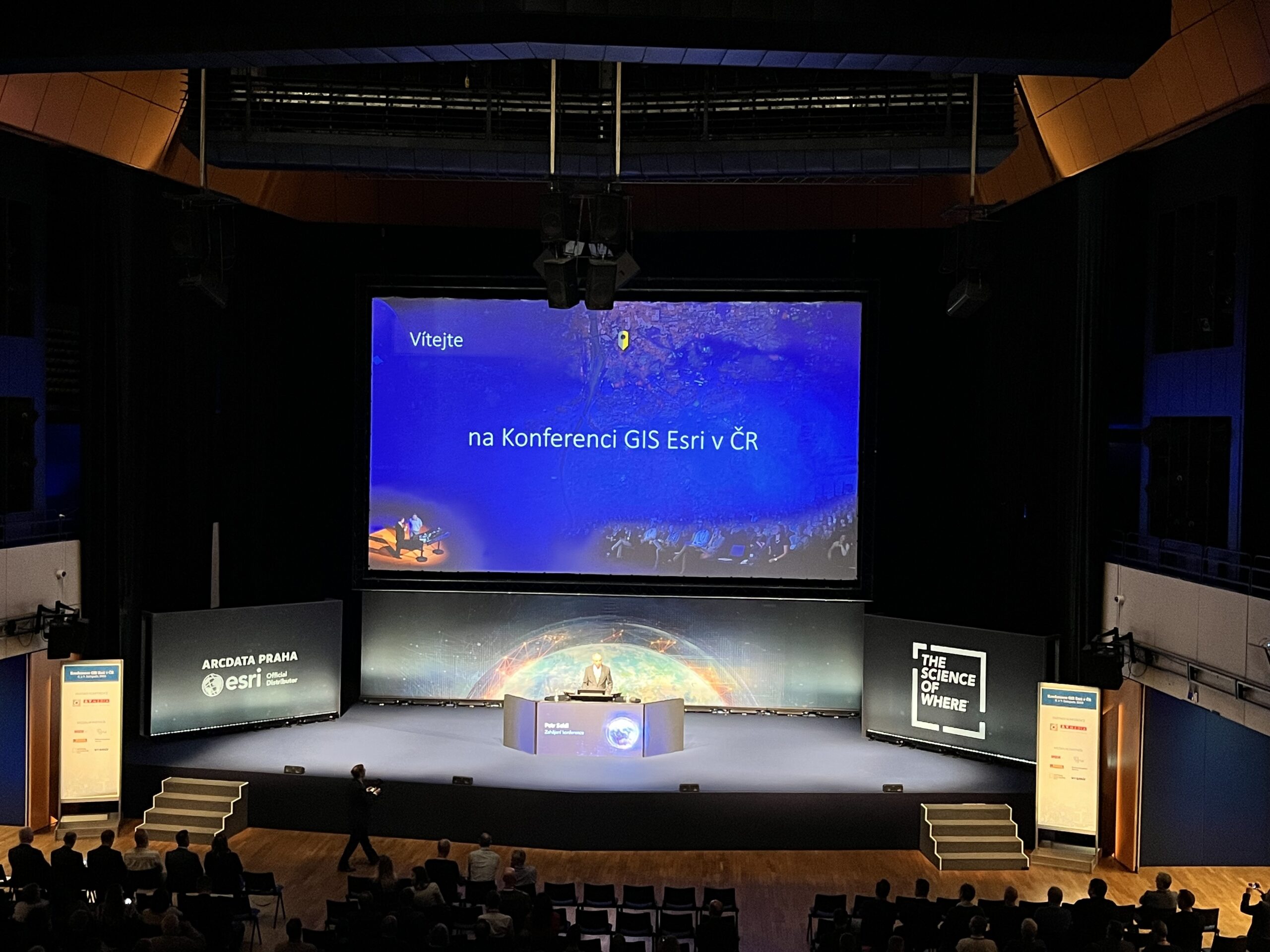
Společnost ARCDATA PRAHA zveřejnila program letošní konference GIS Esri v ČR, která se bude konat 6.-7. listopadu v Kongresovém centru Praha. Hlavními řečníky v úvodní části budou: Petr Seidl – Zahájení konference ARCDATA PRAHA, s.r.o. Václav Žid – Doména Vesmír prizmatem Vojenského zpravodajství Ministerstvo obrany, zástupce ředitele Vojenského zpravodajství Jan Brothánek – Využití GIS HZS […]
The post Konference GIS Esri v ČR (program) appeared first on GISportal.cz.
Konference GIS Esri v ČR (program)
25.9.2024 10:28 GISportal.czSpolečnost ARCDATA PRAHA zveřejnila program letošní konference GIS Esri v ČR, která se bude konat 6.-7. listopadu v Kongresovém centru Praha. Hlavními řečníky v úvodní části budou: Petr Seidl – Zahájení konference ARCDATA PRAHA, s.r.o. Václav Žid – Doména Vesmír prizmatem Vojenského zpravodajství Ministerstvo obrany, zástupce ředitele Vojenského zpravodajství Jan Brothánek – Využití GIS HZS […]
The post Konference GIS Esri v ČR (program) appeared first on GISportal.cz.
Nové letecké měřické snímky ČR
25.9.2024 10:22 ČÚZK - Geoportál Nové letecké měřické snímky ČRV aplikaci Archiv si již můžete prohlédnout letecké měřické snímky z nejnovějšího snímkování východní části území ČR v roce 2024.
Nové letecké snímky lze již také objednávat v aplikacích e-shop nebo Archiv.
Nové letecké měřické snímky ČR
25.9.2024 10:22 ČÚZK - Geoportál Nové letecké měřické snímky ČRV aplikaci Archiv si již můžete prohlédnout letecké měřické snímky z nejnovějšího snímkování východní části území ČR v roce 2024.
Nové letecké snímky lze již také objednávat v aplikaci e-shop.
Nové letecké měřické snímky ČR
25.9.2024 10:22 ČÚZK - Geoportál Nové letecké měřické snímky ČRV aplikaci Archiv si již můžete prohlédnout letecké měřické snímky z nejnovějšího snímkování východní části území ČR v roce 2024.
Nové letecké snímky lze již také objednávat v aplikacích e-shop nebo Archiv.
Nové letecké měřické snímky ČR
25.9.2024 10:22 ČÚZK - Geoportál Nové letecké měřické snímky ČRV aplikaci Archiv si již můžete prohlédnout letecké měřické snímky z nejnovějšího snímkování východní části území ČR v roce 2024.
Nové letecké snímky lze již také objednávat v aplikacích e-shop nebo Archiv.
Odstávka mapových aplikací Geoportálu a výdeje dat
25.9.2024 8:40 Jihočeský krajVe čtvrtek 26.9.2024 od 16:00 do večerních hodin mohou být nedostupné aplikace Geoportálu z důvodu údržby.
rnrnOmlouváme se za komplikace
Webové služby na zkoušku
24.9.2024 14:40 Dálkový přístup k údajům KN ČR Vážení uživatelé webových služeb,webové služby na zkoušku jsou opět dostupné s jedním omezením.
V tuto chvíli není dostupná funkce ctiOS.
O dostupnosti funkce ctiOS Vás budeme informovat.
Za komplikace se omlouváme a děkujeme za pochopení.
Webové služby na zkoušku
24.9.2024 14:40 ČÚZK - předpisy a opatření Vážení uživatelé webových služeb,webové služby na zkoušku jsou opět dostupné s jedním omezením.
V tuto chvíli není dostupná funkce ctiOS.
O dostupnosti funkce ctiOS Vás budeme informovat.
Za komplikace se omlouváme a děkujeme za pochopení.
Nedostupnosť služieb rezortu - aktualizácia
24.9.2024 13:58
ÚGKK SR
Elektronické služby poskytované ÚGKK SR, GKÚ a VÚGK sú v súčasnosti plne funkčné.
Za vzniknuté problémy sa ospravedlňujeme.
Vrchní referent/rada v odd. právní vztahy k nemovitostem Katastrální pracoviště Pelhřimov
23.9.2024 13:10 ČÚZK /Urady/Katastralni-urady/Katastralni-urady/Katastralni-urad-pro-Vysocinu/O-uradu/Aktuality/Vrchni-referent-rada-v-odd-pravni-vztahy-k-nemovitVrchní referent/rada v odd. právní vztahy k nemovitostem Katastrální pracoviště Pelhřimov
23.9.2024 13:10 ČÚZK - předpisy a opatření Katastrální úřad pro Vysočinu zveřejnil novou aktualitu: Oznámení o vyhlášení výběrového řízení na služební místo vrchní referent/rada v oddělení dokumentace KN Katastrálního pracoviště Pelhřimov na Katastrálním úřadu pro Vysočinu, místo výkonu služby Pelhřimov.vrchní referent-rada-aktualizace KN KP Pelhřimov
23.9.2024 12:37 ČÚZK - předpisy a opatření Katastrální úřad pro Vysočinu Katastrální pracoviště Pelhřimovvypisuje výběrové řízení na místo
vrchní referent-rada-aktualizace KN KP Pelhřimov
vrchní referent-rada-aktualizace KN KP Pelhřimov
23.9.2024 12:37 ČÚZK - volná místa Katastrální úřad pro Vysočinu Katastrální pracoviště Pelhřimov vypisuje výběrové řízení na místo vrchní referent-rada-aktualizace KN KP Pelhřimovvrchní referent-rada-aktualizace KN KP Pelhřimov
23.9.2024 12:37 ČÚZK /Urady/Katastralni-urady/Katastralni-urady/Katastralni-urad-pro-Vysocinu/Uredni-deska/Oznameni-a-jina-uredni-sdeleni/Volna-mista/DMS/vrchni-referent-rada-aktualizace-KN-KP-PelhrimovOdborný referent – oddělení dokumentace KN
23.9.2024 12:32 ČÚZK - volná místa Katastrální úřad pro Karlovarský kraj Katastrální pracoviště Karlovy Vary vypisuje výběrové řízení na místo Odborný referent – oddělení dokumentace KNOdborný referent – oddělení dokumentace KN
23.9.2024 12:32 ČÚZK - předpisy a opatření Katastrální úřad pro Karlovarský kraj Katastrální pracoviště Karlovy Varyvypisuje výběrové řízení na místo
Odborný referent – oddělení dokumentace KN
Odborný referent – oddělení dokumentace KN
23.9.2024 12:32 ČÚZK /Urady/Katastralni-urady/Katastralni-urady/Katastralni-urad-pro-Karlovarsky-kraj/Uredni-deska/Oznameni-a-jina-uredni-sdeleni/Volna-mista/DMS/Odborny-referent-–-oddeleni-dokumentace-KN
Nedostupnosť služieb rezortu
23.9.2024 11:38
ÚGKK SR
Z dôvodu neočakávaného výpadku napájania budovy ÚGKK SR nie sú momentálne dostupné žiadne elektronické služby poskytované ÚGKK SR, GKÚ a VÚGK. Na odstránení problému intenzívne pracujeme.
Za vzniknuté problémy sa ospravedlňujeme.
ÚCL vydalo novou aktualizaci OOP pro létání dronů v ČR
23.9.2024 10:00 UAVA Od dneška 23.9.2024 je platná aktualizace Opatření obecné povahy od ÚCL pro létání drony v ČR a jehož aktualizace spočívá především v zavedení gridů ve vztahu k provozu v blízkosti neřízených letišť a úprava podmínek provozu v hustě osídleném prostoru pro bezpilotní letadla třídy C2, více zde ke stažení: https://www.caa.cz/…/oop-omezeny-prostor-lkr10-uas…/20240923-VŘ KP Uherské Hradiště
23.9.2024 8:27 ČÚZK /Aktuality-resort/2024/20240923-VR-KP-Uherske-Hradiste20240923-VŘ KP Uherské Hradiště
23.9.2024 8:27 ČÚZK /Aktuality-resort/2024/20240923-VR-KP-Uherske-Hradiste20240923-VŘ KP Uherské Hradiště
23.9.2024 8:27 ČÚZK - předpisy a opatření Český úřad zeměměřický a katastrální zveřejnil novou aktualitu: Oznámení o vyhlášení výběrového řízení na obsazení služebního místa ředitele/ředitelky Katastrálního pracoviště Uherské Hradiště.20240923-VŘ KP Uherské Hradiště
23.9.2024 8:27 ČÚZK - předpisy a opatření Český úřad zeměměřický a katastrálnízveřejnil novou aktualitu: Oznámení o vyhlášení výběrového řízení na obsazení služebního místa ředitele/ředitelky Katastrálního pracoviště Uherské Hradiště.
20240923-VŘ KP Uherské Hradiště
23.9.2024 8:27 ČÚZK - aktuality v resortu Oznámení o vyhlášení výběrového řízení na obsazení služebního místa ředitele/ředitelky Katastrálního pracoviště Uherské Hradiště.20240923-VŘ KP Uherské Hradiště
23.9.2024 8:27 ČÚZK - aktuality v resortu Oznámení o vyhlášení výběrového řízení na obsazení služebního místa ředitele/ředitelky Katastrálního pracoviště Uherské Hradiště.Sentinel-1B journeys back to Earth
23.9.2024 8:26 ESA Observing the Earth
The Sentinel-1B satellite, the second satellite of the Copernicus Sentinel-1 mission, completed its disposal process – which included lowering its orbit and passivating its systems to ensure re-entry into Earth’s atmosphere within 25 years.
This careful operation highlights the European Union’s and ESA’s commitment to space safety and sustainability and provides valuable experience for the disposal of current and future spacecraft.
20240922-Otevření KP Krnov
22.9.2024 19:38 ČÚZK - aktuality v resortu Katastrální pracoviště Krnov má od 23.9.2024 obnoven plný provoz.20240922-Otevření KP Krnov
22.9.2024 19:38 ČÚZK - předpisy a opatření Český úřad zeměměřický a katastrální zveřejnil novou aktualitu: Katastrální pracoviště Krnov má od 23.9.2024 obnoven plný provoz.20240922-Otevření KP Krnov
22.9.2024 19:38 ČÚZK - aktuality v resortu Katastrální pracoviště Krnov a Katastrální pracoviště Jeseník mají od 23.9.2024 obnoven plný provoz.20240922-Otevření KP Krnov
22.9.2024 19:38 ČÚZK - předpisy a opatření Český úřad zeměměřický a katastrální zveřejnil novou aktualitu: Katastrální pracoviště Krnov a Katastrální pracoviště Jeseník mají od 23.9.2024 obnoven plný provoz.TurboCAD Deluxe 28 CZ – v akční ceně
21.9.2024 19:49 ŠPINAR - software TurboCAD Deluxe 28 CZ v akční ceně do 27. 9. 2024,TurboCAD Deluxe 28 CZ – v akční ceně
21.9.2024 19:49 ŠPINAR - softwareTurboCAD Deluxe 28 CZ v akční ceně do 27. 9. 2024,
The post TurboCAD Deluxe 28 CZ – v akční ceně appeared first on ŠPINAR – software.
Oznam
20.9.2024 19:04
ÚGKK SR
Úrad geodézie, kartografie a katastra Slovenskej republiky oznamuje, že dňa 23. septembra 2024 (pondelok) bude z technických príčin (odstávka elektrickej energie) zatvorený.
Ospravedlňujeme sa za akékoľvek spôsobené komplikácie a ďakujeme za pochopenie.
Rada / odborný rada – ředitel/ka Kanceláře ředitele Katastrálního úřadu pro Zlínský kraj
20.9.2024 12:54 ČÚZK - předpisy a opatření Katastrální úřad pro Zlínský krajvypisuje výběrové řízení na místo
Rada / odborný rada – ředitel/ka Kanceláře ředitele Katastrálního úřadu pro Zlínský kraj
Rada / odborný rada – ředitel/ka Kanceláře ředitele Katastrálního úřadu pro Zlínský kraj
20.9.2024 12:54 ČÚZK - volná místa Katastrální úřad pro Zlínský kraj vypisuje výběrové řízení na místo Rada / odborný rada – ředitel/ka Kanceláře ředitele Katastrálního úřadu pro Zlínský krajRada / odborný rada – ředitel/ka Kanceláře ředitele Katastrálního úřadu pro Zlínský kraj
20.9.2024 12:54 ČÚZK /Urady/Katastralni-urady/Katastralni-urady/Katastralni-urad-pro-Zlinsky-kraj/Uredni-deska/Oznameni-a-jina-uredni-sdeleni/Volna-mista/DMS/Rada-odborny-rada-–-reditel-ka-Kancelare-reditele-20240920_Vrchní referent / rada oddělení právních vztahů k nemovitostem
20.9.2024 12:00 ČÚZK - předpisy a opatření Katastrální úřad pro Středočeský kraj - Katastrální pracoviště Rakovník Vyhlášení výběrového řízení: Vrchní referent / rada oddělení právních vztahů k nemovitostem V části "Úřední deska", v sekci "Oznámení a jiná úřední sdělení" bylo vystaveno "Oznámení o vyhlášení výběrového řízení na obsazení služebního místa Vrchní referent / rada oddělení právních vztahů k nemovitostem"20240920_Vrchní referent / rada oddělení právních vztahů k nemovitostem
20.9.2024 12:00 ČÚZK /Urady/Katastralni-urady/Katastralni-urady/Katastralni-urad-pro-Stredocesky-kraj/Katastralni-pracoviste/KP-Rakovnik/O-uradu/Aktuality/20210922_Odborny-referent-oddeleni-aktualizace-(3)20240920_Rada / odborný rada oddělení právních vztahů k nemovitostem
20.9.2024 12:00 ČÚZK - předpisy a opatření Katastrální úřad pro Středočeský kraj - Katastrální pracoviště Rakovník Vyhlášení výběrového řízení: Rada / odborný rada oddělení právních vztahů k nemovitostem V části "Úřední deska", v sekci "Oznámení a jiná úřední sdělení" bylo vystaveno "Oznámení o vyhlášení výběrového řízení na obsazení služebního místa Rada / odborný rada oddělení právních vztahů k nemovitostem"Vrchní referent / rada oddělení právních vztahů k nemovitostem
20.9.2024 12:00 ČÚZK - volná místa Katastrální úřad pro Středočeský kraj Katastrální pracoviště Rakovník vypisuje výběrové řízení na místo Vrchní referent / rada oddělení právních vztahů k nemovitostemVrchní referent / rada oddělení právních vztahů k nemovitostem
20.9.2024 12:00 ČÚZK - předpisy a opatření Katastrální úřad pro Středočeský kraj Katastrální pracoviště Rakovníkvypisuje výběrové řízení na místo
Vrchní referent / rada oddělení právních vztahů k nemovitostem
Novinka v aplikaci Archiv
20.9.2024 12:00 ČÚZK - Geoportál ArchivPřidána sada posledních vydání všech listů Základní mapy ČR (ZM), která zachycuje dosažený stav tohoto mapového díla před jeho ukončením a nahrazením novou Základní topografickou mapou ČR (ZTM).
Geograf/ka
20.9.2024 11:44 ČÚZK - volná místa Zeměměřický úřad vypisuje výběrové řízení na místo Geograf/kaGeograf/ka
20.9.2024 11:44 ČÚZK - předpisy a opatření Zeměměřický úřadvypisuje výběrové řízení na místo
Geograf/ka
Geograf/ka
20.9.2024 11:44 Zeměměřický úřad Zeměměřický úřadvypisuje výběrové řízení na místo
Geograf/ka
Geograf/ka
20.9.2024 11:44 ČÚZK /Urady/Zememericky-urad/Uredni-deska/Oznameni-a-jina-uredni-sdeleni/Volna-mista/DMS/Geograf-ka-(2)20250402_Vedoucí oddělení dokumentace KN
20.9.2024 11:23 ČÚZK /Urady/Katastralni-urady/Katastralni-urady/Katastralni-urad-pro-Stredocesky-kraj/Katastralni-pracoviste/KP-Rakovnik/O-uradu/Aktuality/20210922_Odborny-referent-oddeleni-aktualizace-(2)20250402_Vedoucí oddělení dokumentace KN
20.9.2024 11:23 ČÚZK - předpisy a opatření Katastrální úřad pro Středočeský kraj - Katastrální pracoviště Rakovník Vyhlášení výběrového řízení: Vedoucí oddělení dokumentace KN V části "Úřední deska", v sekci "Oznámení a jiná úřední sdělení" bylo vystaveno "Oznámení o vyhlášení výběrového řízení na obsazení služebního místa Vedoucí oddělení dokumentace KN"20250130_Referent oddělení dokumentace KN
20.9.2024 11:23 ČÚZK - předpisy a opatření Katastrální úřad pro Středočeský kraj - Katastrální pracoviště Rakovník Vyhlášení výběrového řízení: Referent oddělení dokumentace KN V části "Úřední deska", v sekci "Oznámení a jiná úřední sdělení" bylo vystaveno "Oznámení o vyhlášení výběrového řízení na obsazení služebního místa Referent oddělení dokumentace KN"20240920_Rada / odborný rada oddělení právních vztahů k nemovitostem
20.9.2024 11:23 ČÚZK - předpisy a opatření Katastrální úřad pro Středočeský kraj - Katastrální pracoviště Rakovník Vyhlášení výběrového řízení: Rada / odborný rada oddělení právních vztahů k nemovitostem V části "Úřední deska", v sekci "Oznámení a jiná úřední sdělení" bylo vystaveno "Oznámení o vyhlášení výběrového řízení na obsazení služebního místa Rada / odborný rada oddělení právních vztahů k nemovitostem"20250130_Referent oddělení dokumentace KN
20.9.2024 11:23 ČÚZK /Urady/Katastralni-urady/Katastralni-urady/Katastralni-urad-pro-Stredocesky-kraj/Katastralni-pracoviste/KP-Rakovnik/O-uradu/Aktuality/20210922_Odborny-referent-oddeleni-aktualizace-(2)20240920_Rada / odborný rada oddělení právních vztahů k nemovitostem
20.9.2024 11:23 ČÚZK /Urady/Katastralni-urady/Katastralni-urady/Katastralni-urad-pro-Stredocesky-kraj/Katastralni-pracoviste/KP-Rakovnik/O-uradu/Aktuality/20210922_Odborny-referent-oddeleni-aktualizace-(2)Rada / odborný rada oddělení právních vztahů k nemovitostem
20.9.2024 11:23 ČÚZK - volná místa Katastrální úřad pro Středočeský kraj Katastrální pracoviště Rakovník vypisuje výběrové řízení na místo Rada / odborný rada oddělení právních vztahů k nemovitostemRada / odborný rada oddělení právních vztahů k nemovitostem
20.9.2024 11:23 ČÚZK /Urady/Katastralni-urady/Katastralni-urady/Katastralni-urad-pro-Stredocesky-kraj/Uredni-deska/Oznameni-a-jina-uredni-sdeleni/Volna-mista/DMS/Rada-odborny-rada-oddeleni-pravnich-vztahu-k-nemovRada / odborný rada oddělení právních vztahů k nemovitostem
20.9.2024 11:23 ČÚZK - předpisy a opatření Katastrální úřad pro Středočeský kraj Katastrální pracoviště Rakovníkvypisuje výběrové řízení na místo
Rada / odborný rada oddělení právních vztahů k nemovitostem
Konference Inspirujme se 2024 se po dvou letech vrací na Štrbské Pleso
20.9.2024 11:15 GeoBusinessKonference Inspirujme se 2024 se uskuteční ve dnech 20.–21. listopadu 2024 na Štrbském Plese v hotelu Panorama. Po dvouleté přestávce a loňské vysoko nasazené laťce českými kolegy jsou slovenští kolegové rádi, že mohou na Slovensku opět vytvořit prostor pro sdílení novinek a zkušeností z oblasti environmentální informatiky a geoinformatiky. Akce poskytne prostor k identifikaci aktuálních […]
The post Konference Inspirujme se 2024 se po dvou letech vrací na Štrbské Pleso appeared first on GeoBusiness.
Inspirujme se 2024: Geoinformatici se sejdou na Štrbském Plese
20.9.2024 11:15 GeoBusiness Konference Inspirujme se 2024 se uskuteční ve dnech 20.–21. listopadu 2024 na Štrbském Plese v hotelu Panorama. Po dvouleté přestávce a loňské vysoko nasazené laťce českými kolegy jsou slovenští kolegové rádi, že mohou na Slovensku opět vytvořit prostor pro sdílení novinek a zkušeností z oblasti environmentální informatiky a geoinformatiky. Akce poskytne prostor k identifikaci aktuálních […]Novinka v aplikaci Archiv
20.9.2024 11:00 ČÚZK - Geoportál ArchivPřidána sada posledních vydání všech listů Základní mapy ČR (ZM), která zachycuje dosažený stav tohoto mapového díla před jeho ukončením a nahrazením novou Základní topografickou mapou ČR (ZTM).
Novinka v aplikaci Archiv
20.9.2024 11:00 ČÚZK - Geoportál ArchivPřidána sada posledních vydání všech listů Základní mapy ČR (ZM), která zachycuje dosažený stav tohoto mapového díla před jeho ukončením a nahrazením novou Základní topografickou mapou ČR (ZTM).