


![]()

zprávy
zdroje zpráv:ZABAGED® - aktualizace
4.10.2024 8:00 ČÚZK - Geoportál ZABAGED® - aktualizaceZačátkem října 2024 byly zpřístupněny uživatelům zaktualizované sady těchto typů objektů ZABAGED®: definiční body adresních míst, čerpací stanice pohonných hmot, úřad, pošta, elektrárna, větrný motor, přístaviště, přístav, přívoz, plavební komora, bunkr, lanová dráha, lyžařský vlek, cesty a jejich povrch. Průběžně byly během celého období aktualizovány definiční čáry ulic podle návrhu obcí současně s definičními body náměstí.
Ve 3. čtvrtletí 2024 byla dokončena plošná aktualizace ZABAGED® na celém území mapových listů Základní topografické mapy ČR 1:50 000: 0205-A, 0206-A, 0404-D, 0602-B, 0602-D, 0603-A, 0607-A, 0607-C, 0610-B, 0610-C, 0610-D, 0703-A, 0703-B, 0703-D a 0710-A.
Ve 3. čtvrtletí 2024 byly v rámci aktualizace stavebních objektů v ZABAGED® (na podkladě existující kresby v ISKN, Ortofota ČR, výstupů z dat leteckého laserového skenování a dalších dostupných zdrojů) aktualizovány budovy a další stavební objekty v okresech: Beroun, Bruntál, Česká Lípa, České Budějovice, Děčín, Hradec Králové, Chomutov, Jeseník, Jihlava, Jindřichův Hradec, Karlovy Vary, Kolín, Kroměříž, Mělník, Mladá Boleslav, Most, Nymburk, Olomouc, Opava, Rokycany, Rychnov nad Kněžnou, Sokolov, Svitavy, Šumperk a Teplice.
Více informací o stavu aktualizace je uvedeno v tabulce Informace o produktu, v oddíle Aktualizační cyklus - stav aktualizace.
ZABAGED® - aktualizace
4.10.2024 8:00 ČÚZK - Geoportál ZABAGED® - aktualizaceZačátkem října 2024 byly zpřístupněny uživatelům zaktualizované sady těchto typů objektů ZABAGED®: definiční body adresních míst, čerpací stanice pohonných hmot, úřad, pošta, elektrárna, větrný motor, přístaviště, přístav, přívoz, plavební komora, bunkr, lanová dráha, lyžařský vlek, cesty a jejich povrch. Průběžně byly během celého období aktualizovány definiční čáry ulic podle návrhu obcí současně s definičními body náměstí.
Ve 3. čtvrtletí 2024 byla dokončena plošná aktualizace ZABAGED® na celém území mapových listů Základní topografické mapy ČR 1:50 000: 0205-A, 0206-A, 0404-D, 0602-B, 0602-D, 0603-A, 0607-A, 0607-C, 0610-B, 0610-C, 0610-D, 0703-A, 0703-B, 0703-D a 0710-A.
Ve 3. čtvrtletí 2024 byly v rámci aktualizace stavebních objektů v ZABAGED® (na podkladě existující kresby v ISKN, Ortofota ČR, výstupů z dat leteckého laserového skenování a dalších dostupných zdrojů) aktualizovány budovy a další stavební objekty v okresech: Beroun, Bruntál, Česká Lípa, České Budějovice, Děčín, Hradec Králové, Chomutov, Jeseník, Jihlava, Jindřichův Hradec, Karlovy Vary, Kolín, Kroměříž, Mělník, Mladá Boleslav, Most, Nymburk, Olomouc, Opava, Rokycany, Rychnov nad Kněžnou, Sokolov, Svitavy, Šumperk a Teplice.
Více informací o stavu aktualizace je uvedeno v tabulce Informace o produktu, v oddíle Aktualizační cyklus - stav aktualizace.
Chystáte-li se ke zkouškám AZI, využijte sponzorovaný přístup k normám
3.10.2024 23:30 ZeměměřičČeská komora zeměměřičů upozornila na možnost využít pro čtení závazných norem tzv. sponzorovaný přístup k ČSN. Všechny činnosti související s tvorbou, vydáváním a distribucí technických norem převzala od 1. ledna 2018 od Úřadu pro technickou normalizaci, metrologii a státní zkušebnictví (ÚNMZ) Česká agentura pro standardizaci. Agentura ČAS umožňuje sponzorovaný přístup k ČSN, které jsou pro účely uvedené ve zvláštním právním předpisu závazné, […]
The post Chystáte-li se ke zkouškám AZI, využijte sponzorovaný přístup k normám appeared first on Zeměměřič.
Sentinel-2 unveils the seasonal rhythm of intertidal seagrass
3.10.2024 11:05 ESA Observing the Earth
Thanks to an ESA-funded project and data from the Copernicus Sentinel-2 mission, researchers have revealed seasonal variations in intertidal seagrass across Western Europe and North Africa. As a key indicator of biodiversity, these new findings offer valuable insights for the conservation and restoration of these vital ecosystems.
Vyšel světový report Global State of Drones 2024, kterého je Aliance opět partnerem
3.10.2024 10:00 UAVA Tento týden byl publikován největší světový průzkum na drony Global State of Drones 2024 od DRONEII.com – Drone Industry Insights , kterého je UAVA Aliance dlouhodobě partnerem. Letos se zúčastnilo respondentů z států světa. Report stahujte zde: https://droneii.com/…/global-state-of-drones-white-paper/Sleva 30 % na Fusion 360
3.10.2024 9:32 AdeonAutodesk přináší jedinečnou příležitost pro všechny designéry a inženýry – exkluzivní slevu 30 % na nová roční předplatná oblíbených rozšíření […]
The post Sleva 30 % na Fusion 360 appeared first on Adeon CZ.
20241002-VŘ Administrace databází
2.10.2024 18:06 ČÚZK /Aktuality-resort/2024/20241002-VR-Administrace-databazi20241002-VŘ Administrace databází
2.10.2024 18:06 ČÚZK - předpisy a opatření Český úřad zeměměřický a katastrální zveřejnil novou aktualitu: Oznámení o vyhlášení výběrového řízení na obsazení služebního místa odborný rada - Administrace databází.20241002-VŘ Administrace databází
2.10.2024 18:06 ČÚZK - aktuality v resortu Oznámení o vyhlášení výběrového řízení na obsazení služebního místa odborný rada - Administrace databází.Odborný rada - Administrace databází
2.10.2024 17:59 ČÚZK - volná místa Český úřad zeměměřický a katastrální vypisuje výběrové řízení na místo Odborný rada - Administrace databázíOdborný rada - Administrace databází
2.10.2024 17:59 ČÚZK - předpisy a opatření Český úřad zeměměřický a katastrálnívypisuje výběrové řízení na místo
Odborný rada - Administrace databází
Odborný rada - Administrace databází
2.10.2024 17:59 ČÚZK /Urady/Cesky-urad-zememericky-a-katastralni/Uredni-deska/Oznameni-a-jina-uredni-sdeleni/Volna-mista/DMS/Odborny-rada-Administrace-databaziRada / odborný rada - ředitel/ka odboru Katastrálního pracoviště Uherský Brod
2.10.2024 11:50 ČÚZK - předpisy a opatření Katastrální úřad pro Zlínský kraj Katastrální pracoviště Uherský Brodvypisuje výběrové řízení na místo
Rada / odborný rada - ředitel/ka odboru Katastrálního pracoviště Uherský Brod
Rada / odborný rada - ředitel/ka odboru Katastrálního pracoviště Uherský Brod
2.10.2024 11:50 ČÚZK - volná místa Katastrální úřad pro Zlínský kraj Katastrální pracoviště Uherský Brod vypisuje výběrové řízení na místo Rada / odborný rada - ředitel/ka odboru Katastrálního pracoviště Uherský BrodRada / odborný rada - ředitel/ka odboru Katastrálního pracoviště Uherský Brod
2.10.2024 11:50 ČÚZK /Urady/Katastralni-urady/Katastralni-urady/Katastralni-urad-pro-Zlinsky-kraj/Uredni-deska/Oznameni-a-jina-uredni-sdeleni/Volna-mista/DMS/Rada-odborny-rada-reditel-ka-odboru-Katastralniho-Nový akademický rok odstartoval
2.10.2024 9:30 Katedra geoinformatiky UP OlomoucNa Katedře geoinformatiky jsme úspěšně zahájili nový akademický rok! V prvním ročníku bakalářského studia vítáme více než 50 nových studentů a těšíme se i na nové magistry, jak v českém programu, tak i v anglickém CDE – Erasmus+ EMJM Nezapomínáme ani na další generace a zájemcům o geoinformatiku pravidelně představujeme naše vědecké výstupy, například na […]
The post Nový akademický rok odstartoval first appeared on Katedra geoinformatiky.
Nová verze DAEX DESIGN 25 již brzy na našem trhu
1.10.2024 19:21 ŠPINAR - softwareVážení zákazníci, dovolujeme si Vás informovat, že jsme již úspěšně dokončili vývoj nové verze programů DAEX DESIGN 25, které postupně budeme uvádět na našich internetových stránkách.
The post Nová verze DAEX DESIGN 25 již brzy na našem trhu appeared first on ŠPINAR – software.
Nová verze DAEX DESIGN 25 již brzy na našem webu
1.10.2024 19:21 ŠPINAR - softwareVážení zákazníci, dovolujeme si Vás informovat, že jsme již úspěšně dokončili vývoj nové verze programů DAEX DESIGN 25, které postupně budeme uvádět na našich internetových stránkách.
The post Nová verze DAEX DESIGN 25 již brzy na našem webu appeared first on ŠPINAR – software.
Nová verze DAEX DESIGN 25 již brzy na našem trhu
1.10.2024 19:21 ŠPINAR - software Vážení zákazníci, dovolujeme si Vás informovat, že jsme již úspěšně dokončili vývoj nové verze programů DAEX DESIGN 25, které postupně budeme uvádět na našich internetových stránkách.Dust sparked biggest phytoplankton bloom in decades
1.10.2024 14:40 ESA Observing the Earth
New research reveals that dust carried by the wind from southern Africa towards Madagascar triggered the largest phytoplankton bloom in two decades – and, unusually, this occurred at a time of year when such blooms are rarely seen.
buildingSMART Ecuador Joins as the 36th Chapter
1.10.2024 11:12 buildingSMART.orgLondon, U.K. – October 1, 2024 — buildingSMART International (bSI) is pleased to announce that Ecuador has been formally approved as a "Chapter-in-formation". It will begin work to move to…
The post buildingSMART Ecuador Joins as the 36th Chapter appeared first on buildingSMART International.
buildingSMART Ecuador Joins as the 36th Chapter
1.10.2024 11:12 buildingSMART.orgLondon, U.K. – October 1, 2024 — buildingSMART International (bSI) is pleased to announce that Ecuador has been formally approved as a "Chapter-in-formation". It will begin work to move to the "Developing Chapter" status over the coming months. This approval follows a successful submission, and the new Chapter will be established under the BIM Forum…
The post buildingSMART Ecuador Joins as the 36th Chapter appeared first on buildingSMART International.
buildingSMART Ecuador Joins as the 36th Chapter
1.10.2024 11:12 buildingSMART.orgThe post buildingSMART Ecuador Joins as the 36th Chapter appeared first on buildingSMART International.
buildingSMART International Works Closely with the Alliance for OpenUSD
1.10.2024 11:07 buildingSMART.orgLondon, U.K. – October 1, 2024 — buildingSMART International (bSI) and the Alliance for OpenUSD (AOUSD) are pleased to announce a liaison agreement to facilitate cooperation on topics of mutual…
The post buildingSMART International Works Closely with the Alliance for OpenUSD appeared first on buildingSMART International.
buildingSMART International Intends to Sign a Liaison Agreement with the Alliance for OpenUSD
1.10.2024 11:07 buildingSMART.orgLondon, U.K. – October 1, 2024 — buildingSMART International (bSI) and the Alliance for OpenUSD (AOUSD) are pleased to announce a liaison agreement to facilitate cooperation on topics of mutual…
The post buildingSMART International Intends to Sign a Liaison Agreement with the Alliance for OpenUSD appeared first on buildingSMART International.
buildingSMART International Signs Liaison Agreement with the Alliance for OpenUSD
1.10.2024 11:07 buildingSMART.orgLondon, U.K. – October 1, 2024 — buildingSMART International (bSI) and the Alliance for OpenUSD (AOUSD) are pleased to announce a liaison agreement to facilitate cooperation on topics of mutual…
The post buildingSMART International Signs Liaison Agreement with the Alliance for OpenUSD appeared first on buildingSMART International.
Odborný referent - návrh zápisu v katastru v oddělení aktualizace KN Katastrálního pracoviště Valašs
1.10.2024 10:54 ČÚZK /Urady/Katastralni-urady/Katastralni-urady/Katastralni-urad-pro-Zlinsky-kraj/Uredni-deska/Oznameni-a-jina-uredni-sdeleni/Volna-mista/DMS/Odborny-referent-navrh-zapisu-v-katastru-v-oddelenOdborný referent - návrh zápisu v katastru v oddělení aktualizace KN Katastrálního pracoviště Valašs
1.10.2024 10:54 ČÚZK - předpisy a opatření Katastrální úřad pro Zlínský kraj Katastrální pracoviště Valašské Meziříčívypisuje výběrové řízení na místo
Odborný referent - návrh zápisu v katastru v oddělení aktualizace KN Katastrálního pracoviště Valašské Meziříčí
Odborný referent - návrh zápisu v katastru v oddělení aktualizace KN Katastrálního pracoviště Valašs
1.10.2024 10:54 ČÚZK - volná místa Katastrální úřad pro Zlínský kraj Katastrální pracoviště Valašské Meziříčí vypisuje výběrové řízení na místo Odborný referent - návrh zápisu v katastru v oddělení aktualizace KN Katastrálního pracoviště ValašsCooperation with Industrial Digital Twin Association
1.10.2024 9:00 buildingSMART.orgLondon, U.K. – October 1, 2024 — buildingSMART International (bSI) and the Industrial Digital Twin Association (IDTA) are pleased to announce their intention to cooperate on a not-for-profit basis to…
The post Cooperation with Industrial Digital Twin Association appeared first on buildingSMART International.
buildingSMART International and the Industrial Digital Twin Association Sign Cooperation Agreement
1.10.2024 9:00 buildingSMART.orgLondon, U.K. – October 1, 2024 — buildingSMART International (bSI) and the Industrial Digital Twin Association (IDTA) are pleased to announce their intention to cooperate on a not-for-profit basis to…
The post buildingSMART International and the Industrial Digital Twin Association Sign Cooperation Agreement appeared first on buildingSMART International.
Unveiling the hidden snow dunes shaping Antarctica's frozen landscape
1.10.2024 9:00 ESA Observing the Earth
Sand dunes are a familiar sight along beaches and in deserts. While we know how regular sand dunes are formed, much less is known about dunes made of snow. In a new study, scientists have analysed the vast snow dunes across Antarctica – reshaping our understanding of the continent's surface dynamics.
This research sheds light on the unexplored world of Antarctic snow dunes, offering a fresh perspective on the complex interactions between wind, snow and climate in one of Earth's harshest environments.
20241001 - Rozšíření možnosti zpracování změnových vět v ISKN 10.2
1.10.2024 8:34 ČÚZK - předpisy a opatření20241001 - Rozšíření možnosti zpracování změnových vět v ISKN 10.2
1.10.2024 8:34 ČÚZK - Výměnný formát ISKN20241001 - Rozšíření možnosti zpracování změnových vět v ISKN 10.2
1.10.2024 8:34 ČÚZK - Výměnný formát ISKNPopis změn ve formátu PDF
20241001 - Rozšíření možnosti zpracování změnových vět v ISKN 10.2
1.10.2024 8:34 ČÚZK - Výměnný formát ISKN20241001 - Rozšíření možnosti zpracování změnových vět v ISKN 10.2
1.10.2024 8:34 ČÚZK - předpisy a opatřeníPopis změn ve formátu PDF
ESA releases new strategy for Earth observation
30.9.2024 14:16 ESA Observing the Earth
ESA has released its new Earth Observation Science Strategy, Earth Science in Action for Tomorrow’s World. Responding to the escalating threats from climate change, biodiversity loss, pollution and extreme weather and the need to take action to address these threats, this forward-looking strategy outlines a bold vision for Earth science through to 2040.
vrchní referent/rada v oddělení dokumentace KN na Katastrálním pracovišti Boskovice
30.9.2024 13:37 ČÚZK - volná místa Katastrální úřad pro Jihomoravský kraj Katastrální pracoviště Boskovice vypisuje výběrové řízení na místo vrchní referent/rada v oddělení dokumentace KN na Katastrálním pracovišti Boskovicevrchní referent/rada v oddělení dokumentace KN na Katastrálním pracovišti Boskovice
30.9.2024 13:37 ČÚZK /Urady/Katastralni-urady/Katastralni-urady/Katastralni-urad-pro-Jihomoravsky-kraj/Uredni-deska/Oznameni-a-jina-uredni-sdeleni/Volna-mista/DMS/vrchni-referent-rada-v-oddeleni-dokumentace-KN-na-vrchní referent/rada v oddělení dokumentace KN na Katastrálním pracovišti Boskovice
30.9.2024 13:37 ČÚZK - předpisy a opatření Katastrální úřad pro Jihomoravský kraj Katastrální pracoviště Boskovicevypisuje výběrové řízení na místo
vrchní referent/rada v oddělení dokumentace KN na Katastrálním pracovišti Boskovice
VŘ ředitel/ka Zeměměřického odboru Pardubice
30.9.2024 11:12 ČÚZK - volná místa Zeměměřický úřad vypisuje výběrové řízení na místo VŘ ředitel/ka Zeměměřického odboru PardubiceVŘ ředitel/ka Zeměměřického odboru Pardubice
30.9.2024 11:12 Zeměměřický úřad Zeměměřický úřadvypisuje výběrové řízení na místo
VŘ ředitel/ka Zeměměřického odboru Pardubice
VŘ ředitel/ka Zeměměřického odboru Pardubice
30.9.2024 11:12 ČÚZK /Urady/Zememericky-urad/Uredni-deska/Oznameni-a-jina-uredni-sdeleni/Volna-mista/DMS/VR-reditel-ka-Zememerickeho-odboru-PardubiceVŘ ředitel/ka Zeměměřického odboru Pardubice
30.9.2024 11:12 ČÚZK - předpisy a opatření Zeměměřický úřadvypisuje výběrové řízení na místo
VŘ ředitel/ka Zeměměřického odboru Pardubice
VŘ ředitel/ka Odboru Zabaged
30.9.2024 11:10 ČÚZK - předpisy a opatření Zeměměřický úřadvypisuje výběrové řízení na místo
VŘ ředitel/ka Odboru Zabaged
VŘ ředitel/ka Odboru Zabaged
30.9.2024 11:10 ČÚZK - volná místa Zeměměřický úřad vypisuje výběrové řízení na místo VŘ ředitel/ka Odboru ZabagedVŘ ředitel/ka Odboru Zabaged
30.9.2024 11:10 Zeměměřický úřad Zeměměřický úřadvypisuje výběrové řízení na místo
VŘ ředitel/ka Odboru Zabaged
VŘ ředitel/ka Odboru Zabaged
30.9.2024 11:10 ČÚZK /Urady/Zememericky-urad/Uredni-deska/Oznameni-a-jina-uredni-sdeleni/Volna-mista/DMS/VR-reditel-ka-Odboru-ZabagedKrátka správa č. 37/2024
30.9.2024 10:28 Komora geodetů a kartografů SRThe post Krátka správa č. 37/2024 appeared first on Komora geodetov a kartografov.
Krátka správa č. 36/2024
30.9.2024 10:21 Komora geodetů a kartografů SRThe post Krátka správa č. 36/2024 appeared first on Komora geodetov a kartografov.
Krátka správa č. 35/2024
30.9.2024 10:19 Komora geodetů a kartografů SRThe post Krátka správa č. 35/2024 appeared first on Komora geodetov a kartografov.
Mapová aplikace ÚPD - nové dokumentace
30.9.2024 8:42 Jihočeský krajV mapové aplikaci Územně plánovací dokumentace obcí byla aktualizována ÚPD obcí ORP Písek - Skály, Podolí I., ORP Třeboň - Majdalena, ORP Strakonice - Sousedovice, ORP Soběslav - Vesce, ORP České Budějovice - České Budějovice, Homole, Vitín, Lišov, ORP Strakonice – Strakonice, Přešťovice, ORP Tábor - Radětice, ORP Soběslav - Skalice, ORP Dačice - Staré Hobzí, ORP Vodňany - Stožice, ORP Vimperk - Strážný, ORP Jindřichův Hradec - Vícemil, ORP Týn nad Vltavou - Všemyslice.
20240930-Parkování ul. Vršní
30.9.2024 8:14 ČÚZK - aktuality v resortu Dne 1. října 2024 dojde ke změně režimu parkování vozidel u budovy katastrálních úřadů v Praze - Kobylisích. Pro klienty našich úřadů jsme nově ve dnech pondělí až pátek od 7:00 do 17 hodin vyhradili bezplatné parkoviště s vjezdem z ulice Vršní. Na tomto parkovišti lze vozidlo ponechat po dobu max. 60 minut s parkovacím kotoučem (hodinami) viditelně umístěným za oknem vozidla. Parkovací kotouč lze nahradit papírovou kartou s ručně napsaným časem příjezdu (například: "Příjezd 10:30 hod."). Přijet k nám ale samozřejmě můžete i MHD, sídlíme přímo na metru C - stanice Kobylisy.20240930-Parkování ul. Vršní
30.9.2024 8:14 ČÚZK - aktuality v resortu Dne 1. října 2024 dojde ke změně režimu parkování vozidel u budovy katastrálních úřadů v Praze - Kobylisích. Pro klienty našich úřadů jsme nově ve dnech pondělí až pátek od 7:00 do 17 hodin vyhradili bezplatné parkoviště s vjezdem z ulice Vršní. Na tomto parkovišti lze vozidlo ponechat po dobu max. 60 minut s parkovacím kotoučem (hodinami) viditelně umístěným za oknem vozidla. Parkovací kotouč lze nahradit papírovou kartou s ručně napsaným časem příjezdu (například: "Příjezd 10:30 hod."). Přijet k nám ale samozřejmě můžete i MHD, sídlíme přímo na metru C - stanice Kobylisy.20240930-Parkování ul. Vršní
30.9.2024 8:14 ČÚZK - předpisy a opatření Český úřad zeměměřický a katastrálnízveřejnil novou aktualitu: Dne 1. října 2024 dojde ke změně režimu parkování vozidel u budovy katastrálních úřadů v Praze - Kobylisích. Pro klienty našich úřadů jsme nově ve dnech pondělí až pátek od 7:00 do 17 hodin vyhradili bezplatné parkoviště s vjezdem z ulice Vršní. Na tomto parkovišti lze vozidlo ponechat po dobu max. 60 minut s parkovacím kotoučem (hodinami) viditelně umístěným za oknem vozidla. Parkovací kotouč lze nahradit papírovou kartou s ručně napsaným časem příjezdu (například: "Příjezd 10:30 hod."). Přijet k nám ale samozřejmě můžete i MHD, sídlíme přímo na metru C - stanice Kobylisy.
výpočetní technika - monitory
30.9.2024 7:18 ČÚZK /Urady/Katastralni-urady/Katastralni-urady/Katastralni-urad-pro-Vysocinu/Nabidky-majetku/vypocetni-technika-monitoryvýpočetní technika - monitory
30.9.2024 7:18 ČÚZK - předpisy a opatřeníKatastrální úřad pro Vysočinu - Katastrální pracoviště Třebíč nabízí nepotřebný majetek k odkupu. Jedná se o
výpočetní technika - monitory
Aktuální stav DTM krajů, referát Petra Pavlince a Martina Tejkala na konferenci Mapy jsou pro každého
30.9.2024 3:05 GeoBusiness Na desátém ročníku konference Mapy jsou pro každého, která se konala ve dnech 24. a 25. září, vystoupili tak0 Petr Pavlinec a Martin Tejkal z Kraje Vysočina. Jejich referát se týkal aktuálního stavu krajských digitálních technických map. zdroj: www.giskonference.czProgramy pro dřevařský obor – DAEX DESIGN – Reference našich uživatelů
28.9.2024 19:19 ŠPINAR - softwareReference truhlářských a nábytkářských firem - uživatelů DAEX DESIGN
The post Programy pro dřevařský obor – DAEX DESIGN – Reference našich uživatelů appeared first on ŠPINAR – software.
Programy pro dřevařský obor – DAEX DESIGN – Reference našich uživatelů
28.9.2024 19:19 ŠPINAR - softwareReference truhlářských a nábytkářských firem - uživatelů DAEX DESIGN
The post Programy pro dřevařský obor – DAEX DESIGN – Reference našich uživatelů appeared first on ŠPINAR – software.
Programy pro dřevařský obor – DAEX DESIGN – Reference našich uživatelů
28.9.2024 19:19 ŠPINAR - software Reference truhlářských a nábytkářských firem - uživatelů DAEX DESIGNOdborný referent - zápisy v řízení V a Z v oddělení právních vztahů k nemovitostem Katastrálního pra
27.9.2024 13:26 ČÚZK /Urady/Katastralni-urady/Katastralni-urady/Katastralni-urad-pro-Zlinsky-kraj/Uredni-deska/Oznameni-a-jina-uredni-sdeleni/Volna-mista/DMS/Odborny-referent-zapisy-v-rizeni-V-a-Z-v-oddeleni-Odborný referent - zápisy v řízení V a Z v oddělení právních vztahů k nemovitostem Katastrálního pra
27.9.2024 13:26 ČÚZK - volná místa Katastrální úřad pro Zlínský kraj Katastrální pracoviště Uherský Brod vypisuje výběrové řízení na místo Odborný referent - zápisy v řízení V a Z v oddělení právních vztahů k nemovitostem Katastrálního praOdborný referent - zápisy v řízení V a Z v oddělení právních vztahů k nemovitostem Katastrálního pra
27.9.2024 13:26 ČÚZK - předpisy a opatření Katastrální úřad pro Zlínský kraj Katastrální pracoviště Uherský Brodvypisuje výběrové řízení na místo
Odborný referent - zápisy v řízení V a Z v oddělení právních vztahů k nemovitostem Katastrálního pracoviště Uherský Brod
Earth from Space: Northern Territory, Australia
27.9.2024 10:00 ESA Observing the Earth Image:
This image captured by the Copernicus Sentinel-1 mission reveals the impact of severe flooding following heavy rain that hit Australia’s Northern Territory in March 2024.
Image:
This image captured by the Copernicus Sentinel-1 mission reveals the impact of severe flooding following heavy rain that hit Australia’s Northern Territory in March 2024.
20240927- VŘ KP Ústecký kraj
27.9.2024 9:14 ČÚZK - předpisy a opatření Český úřad zeměměřický a katastrální zveřejnil novou aktualitu: Oznámení o vyhlášení výběrových řízení na obsazení služebních míst ředitele/ředitelky Katastrálního pracoviště Teplice, Katastrálního pracoviště Chomutov, Katastrálního pracoviště Litoměřice, Katastrálního pracoviště Most, Katastrálního pracoviště Žatec, Katastrálního pracoviště Louny a Katastrálního pracoviště Rumburk.20240927- VŘ KP Ústecký kraj
27.9.2024 9:14 ČÚZK - aktuality v resortu Oznámení o vyhlášení výběrových řízení na obsazení služebních míst ředitele/ředitelky Katastrálního pracoviště Teplice, Katastrálního pracoviště Chomutov, Katastrálního pracoviště Litoměřice, Katastrálního pracoviště Most, Katastrálního pracoviště Žatec, Katastrálního pracoviště Louny a Katastrálního pracoviště Rumburk.20240927- VŘ KP Ústecký kraj
27.9.2024 9:14 ČÚZK - předpisy a opatření Český úřad zeměměřický a katastrálnízveřejnil novou aktualitu: Oznámení o vyhlášení výběrových řízení na obsazení služebních míst ředitele/ředitelky Katastrálního pracoviště Teplice, Katastrálního pracoviště Chomutov, Katastrálního pracoviště Litoměřice, Katastrálního pracoviště Most, Katastrálního pracoviště Žatec, Katastrálního pracoviště Louny a Katastrálního pracoviště Rumburk.
20240927- VŘ KP Ústecký kraj
27.9.2024 9:14 ČÚZK - aktuality v resortu Oznámení o vyhlášení výběrových řízení na obsazení služebních míst ředitele/ředitelky Katastrálního pracoviště Teplice, Katastrálního pracoviště Chomutov, Katastrálního pracoviště Litoměřice, Katastrálního pracoviště Most, Katastrálního pracoviště Žatec, Katastrálního pracoviště Louny a Katastrálního pracoviště Rumburk.20240927- VŘ KP Ústecký kraj
27.9.2024 9:14 ČÚZK - aktuality v resortu Oznámení o vyhlášení výběrových řízení na obsazení služebních míst ředitele/ředitelky Katastrálního pracoviště Teplice, Katastrálního pracoviště Chomutov, Katastrálního pracoviště Litoměřice, Katastrálního pracoviště Most, Katastrálního pracoviště Žatec, Katastrálního pracoviště Louny a Katastrálního pracoviště Rumburk.Sentinel-2C captures stunning glimpse of the Moon
26.9.2024 16:00 ESA Observing the Earth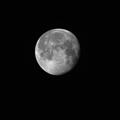 Image:
On 20 September, the Copernicus Sentinel-2C satellite captured its first stunning image of the Moon, achieved by rolling the satellite sideways in a unique manoeuvre. Although Sentinel-2C is primarily designed for Earth observation, this image – intended for calibration and cross-mission comparisons – exceeded expectations.
Image:
On 20 September, the Copernicus Sentinel-2C satellite captured its first stunning image of the Moon, achieved by rolling the satellite sideways in a unique manoeuvre. Although Sentinel-2C is primarily designed for Earth observation, this image – intended for calibration and cross-mission comparisons – exceeded expectations.
Sentinel-2C captures stunning glimpse of the Moon
26.9.2024 16:00 ESA Observing the Earth Image:
On 20 September, the Copernicus Sentinel-2C satellite captured its first stunning image of the Moon, achieved by rolling the satellite sideways in a unique manoeuvre. Although Sentinel-2C is primarily designed for Earth observation, this image – intended for calibration and cross-mission comparisons – exceeded expectations.
Image:
On 20 September, the Copernicus Sentinel-2C satellite captured its first stunning image of the Moon, achieved by rolling the satellite sideways in a unique manoeuvre. Although Sentinel-2C is primarily designed for Earth observation, this image – intended for calibration and cross-mission comparisons – exceeded expectations.
odborný rada - vedoucí personálního oddělení kanceláře ředitele Katastrálního úřadu pro Královéhrade
26.9.2024 13:26 ČÚZK - předpisy a opatření Katastrální úřad pro Královéhradecký kraj kancelář ředitelevypisuje výběrové řízení na místo
odborný rada - vedoucí personálního oddělení kanceláře ředitele Katastrálního úřadu pro Královéhradecký kraj
odborný rada - vedoucí personálního oddělení kanceláře ředitele Katastrálního úřadu pro Královéhrade
26.9.2024 13:26 ČÚZK - volná místa Katastrální úřad pro Královéhradecký kraj kancelář ředitele vypisuje výběrové řízení na místo odborný rada - vedoucí personálního oddělení kanceláře ředitele Katastrálního úřadu pro Královéhradeodborný rada - vedoucí personálního oddělení kanceláře ředitele Katastrálního úřadu pro Královéhrade
26.9.2024 13:26 ČÚZK /Urady/Katastralni-urady/Katastralni-urady/Katastralni-urad-pro-Kralovehradecky-kraj/Uredni-deska/Oznameni-a-jina-uredni-sdeleni/Volna-mista/DMS/odborny-rada-vedouci-personalniho-oddeleni-kancela20240927 - volné místo představeného - Ředitel/ka KP Rumburk na Katastrálním úřadu pro Ústecký kraj
26.9.2024 12:05 ČÚZK /Urady/Katastralni-urady/Katastralni-urady/Katastralni-urad-pro-Ustecky-kraj/Katastralni-pracoviste/KP-Rumburk/O-uradu/Aktuality/20240927-volne-misto-predstaveneho-Reditel-ka-KP-R20240927 - volné místo představeného - Ředitel/ka KP Rumburk na Katastrálním úřadu pro Ústecký kraj
26.9.2024 12:05 ČÚZK - předpisy a opatření Katastrální úřad pro Ústecký kraj - Katastrální pracoviště Rumburk zveřejnil novou aktualitu: Nabídka volného služebního místa představeného - Ředitel / ředitelka Katastrálního pracoviště Rumburk na Katastrálním úřadu pro Ústecký kraj20240927 - volné místo představeného - Ředitel/ka KP Rumburk na Katastrálním úřadu pro Ústecký kraj
26.9.2024 12:04 ČÚZK /Urady/Katastralni-urady/Katastralni-urady/Katastralni-urad-pro-Ustecky-kraj/O-uradu/Aktuality/20240927-volne-misto-predstaveneho-Reditel-ka-KP-R20240927 - volné místo představeného - Ředitel/ka KP Rumburk na Katastrálním úřadu pro Ústecký kraj
26.9.2024 12:04 ČÚZK - předpisy a opatření Katastrální úřad pro Ústecký kraj - Katastrální pracoviště Rumburk zveřejnil novou aktualitu: Nabídka volného služebního místa představeného - Ředitel / ředitelka Katastrálního pracoviště Rumburk na Katastrálním úřadu pro Ústecký krajŘeditel / ředitelka Katastrálního pracoviště Rumburk na Katastrálním úřadu pro Ústecký kraj
26.9.2024 12:03 ČÚZK /Urady/Katastralni-urady/Katastralni-urady/Katastralni-urad-pro-Ustecky-kraj/Uredni-deska/Oznameni-a-jina-uredni-sdeleni/Volna-mista/DMS/Reditel-reditelka-Katastralniho-pracoviste-RumburkŘeditel / ředitelka Katastrálního pracoviště Rumburk na Katastrálním úřadu pro Ústecký kraj
26.9.2024 12:03 ČÚZK - předpisy a opatření Katastrální úřad pro Ústecký kraj Katastrální pracoviště Rumburkvypisuje výběrové řízení na místo
Ředitel / ředitelka Katastrálního pracoviště Rumburk na Katastrálním úřadu pro Ústecký kraj
Ředitel / ředitelka Katastrálního pracoviště Rumburk na Katastrálním úřadu pro Ústecký kraj
26.9.2024 12:03 ČÚZK - volná místa Katastrální úřad pro Ústecký kraj Katastrální pracoviště Rumburk vypisuje výběrové řízení na místo Ředitel / ředitelka Katastrálního pracoviště Rumburk na Katastrálním úřadu pro Ústecký kraj20240927 - volné místo představeného - Ředitel/ka KP Louny na Katastrálním úřadu pro Ústecký kraj
26.9.2024 11:56 ČÚZK - předpisy a opatření Katastrální úřad pro Ústecký kraj - Katastrální pracoviště Louny zveřejnil novou aktualitu: Nabídka volného služebního místa představeného - Ředitel / ředitelka Katastrálního pracoviště Louny na Katastrálním úřadu pro Ústecký kraj20240927 - volné místo představeného - Ředitel/ka KP Louny na Katastrálním úřadu pro Ústecký kraj
26.9.2024 11:56 ČÚZK /Urady/Katastralni-urady/Katastralni-urady/Katastralni-urad-pro-Ustecky-kraj/Katastralni-pracoviste/KP-Louny/O-uradu/Aktuality/20240927-volne-misto-predstaveneho-Reditel-ka-(1)20240927 - volné místo představeného - Ředitel/ka KP Louny na Katastrálním úřadu pro Ústecký kraj
26.9.2024 11:56 ČÚZK /Urady/Katastralni-urady/Katastralni-urady/Katastralni-urad-pro-Ustecky-kraj/O-uradu/Aktuality/20240927-volne-misto-predstaveneho-Reditel-ka-(1)20240927 - volné místo představeného - Ředitel/ka KP Louny na Katastrálním úřadu pro Ústecký kraj
26.9.2024 11:56 ČÚZK - předpisy a opatření Katastrální úřad pro Ústecký kraj - Katastrální pracoviště Louny zveřejnil novou aktualitu: Nabídka volného služebního místa představeného - Ředitel / ředitelka Katastrálního pracoviště Louny na Katastrálním úřadu pro Ústecký krajŘeditel / ředitelka Katastrálního pracoviště Louny na Katastrálním úřadu pro Ústecký kraj
26.9.2024 11:55 ČÚZK - předpisy a opatření Katastrální úřad pro Ústecký kraj Katastrální pracoviště Lounyvypisuje výběrové řízení na místo
Ředitel / ředitelka Katastrálního pracoviště Louny na Katastrálním úřadu pro Ústecký kraj
Ředitel / ředitelka Katastrálního pracoviště Louny na Katastrálním úřadu pro Ústecký kraj
26.9.2024 11:55 ČÚZK /Urady/Katastralni-urady/Katastralni-urady/Katastralni-urad-pro-Ustecky-kraj/Uredni-deska/Oznameni-a-jina-uredni-sdeleni/Volna-mista/DMS/Reditel-reditelka-Katastralniho-pracoviste-Louny-nŘeditel / ředitelka Katastrálního pracoviště Louny na Katastrálním úřadu pro Ústecký kraj
26.9.2024 11:55 ČÚZK - volná místa Katastrální úřad pro Ústecký kraj Katastrální pracoviště Louny vypisuje výběrové řízení na místo Ředitel / ředitelka Katastrálního pracoviště Louny na Katastrálním úřadu pro Ústecký kraj20240927 - volné místo představeného - Ředitel/ka KP Žatec na Katastrálním úřadu pro Ústecký kraj
26.9.2024 11:46 ČÚZK - předpisy a opatření Katastrální úřad pro Ústecký kraj - Katastrální pracoviště Žatec zveřejnil novou aktualitu: Nabídka volného služebního místa představeného - Ředitel / ředitelka Katastrálního pracoviště Žatec na Katastrálním úřadu pro Ústecký kraj20240927 - volné místo představeného - Ředitel/ka KP Žatec na Katastrálním úřadu pro Ústecký kraj
26.9.2024 11:46 ČÚZK /Urady/Katastralni-urady/Katastralni-urady/Katastralni-urad-pro-Ustecky-kraj/Katastralni-pracoviste/KP-Zatec/O-uradu/Aktuality/20240927-volne-misto-predstaveneho-Reditel-ka-KP-Z20240927 - volné místo představeného - Ředitel/ka KP Žatec na Katastrálním úřadu pro Ústecký kraj
26.9.2024 11:45 ČÚZK - předpisy a opatření Katastrální úřad pro Ústecký kraj - Katastrální pracoviště Žatec zveřejnil novou aktualitu: Nabídka volného služebního místa představeného - Ředitel / ředitelka Katastrálního pracoviště Žatec na Katastrálním úřadu pro Ústecký kraj20240927 - volné místo představeného - Ředitel/ka KP Žatec na Katastrálním úřadu pro Ústecký kraj
26.9.2024 11:45 ČÚZK /Urady/Katastralni-urady/Katastralni-urady/Katastralni-urad-pro-Ustecky-kraj/O-uradu/Aktuality/20240927-volne-misto-predstaveneho-Reditel-ka-KP-ZŘeditel / ředitelka Katastrálního pracoviště Žatec na Katastrálním úřadu pro Ústecký kraj
26.9.2024 11:44 ČÚZK /Urady/Katastralni-urady/Katastralni-urady/Katastralni-urad-pro-Ustecky-kraj/Uredni-deska/Oznameni-a-jina-uredni-sdeleni/Volna-mista/DMS/Reditel-reditelka-Katastralniho-pracoviste-Zatec-nŘeditel / ředitelka Katastrálního pracoviště Žatec na Katastrálním úřadu pro Ústecký kraj
26.9.2024 11:44 ČÚZK - předpisy a opatření Katastrální úřad pro Ústecký kraj Katastrální pracoviště Žatecvypisuje výběrové řízení na místo
Ředitel / ředitelka Katastrálního pracoviště Žatec na Katastrálním úřadu pro Ústecký kraj