


zprávy
zdroje zpráv:Giant A-68A iceberg loses chunk of ice
18.12.2020 15:10 ESA Observing the Earth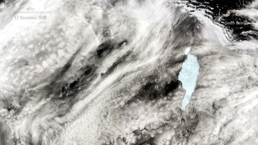
A large block of ice has broken off the northern tip of the A-68A iceberg as seen in new images captured by the Copernicus Sentinel-3 mission.
Giant A-68A iceberg loses chunk of ice
18.12.2020 15:10 ESA Observing the Earth
A large block of ice has broken off the northern tip of the A-68A iceberg as seen in new images captured by the Copernicus Sentinel-3 mission.
ArcGIS Pro 2.7
18.12.2020 12:55 ARCDATANa stránkách my.esri.com si můžete stáhnout aplikaci ArcGIS Pro 2.7. V této aktualitě vám přiblížíme některé z nejzajímavějších novinek. Aplikace je zatím dostupná v anglické verzi, balíček s českou lokalizací bude dostupný přibližně na začátku února.
Mód prolnutí, funkci známou z grafických programů GIMP nebo Adobe Photoshop, můžeme aplikovat na jednotlivé vrstvy, a dokonce i na jednotlivé prvky. Nastavení módu prolnutí naleznete na kartě Vzhled vrstvy, hned pod nastavením průhlednosti.

Při výběru barvy lze použít kapátko.

Při volbě „upravit všechny symboly“, když upravujeme symboly roztříděné do několika kategorií, máme v náhledu možnost přepínat mezi vzhledy jednotlivých kategorií, abychom mohli naše změny lépe posoudit v kontextu nastavených tříd.
Představen je nový formát mobilní geodatabáze na základě SQLite pro snazší přenositelnost dat na různých platformách – například tím, že se jedná o jediný soubor.
Přibyly také různé nástroje pro analýzu pohybu objektů, které jejich trasy analyzují a rozpoznají, kdy se objekty potkaly a kdy měly společnou cestu. Přibyl také nový datový typ 3D Object layer, což je vylepšená varianta typu Multipatch. A protože se ArcGIS Pro často provozuje i na přenosných počítačích, lze zapnout i sběr dat pomocí připojeného GNSS zařízení.

Celý obsah vyskakovacích oken lze editovat v HTML. Je již také možné omezit zobrazení mapy jen na některá měřítka.

Více možností je i pro popisky – pro batymetrické vrstevnice v hloubkových metrech je možné natočit popisky tak, aby směřovaly dolů, ačkoliv hodnoty hloubkových vrstevnic jsou kladné (10, 20, 30…).

Lepší je tvorba tabulkového seznamu neumístěných popisků a upraveny jsou také volby popisků, které jsou k objektu připojeny čarou. ArcGIS Pro podporuje variabilní fonty – to jsou fonty, u kterých můžeme tloušťku a tučnost písmen plynule vybírat nastavením určitých parametrů.

Načíst si můžeme také barevné palety Pantone. Pro bodové symboly můžeme použít nový efekt Circular Sector, který umožňuje vytvářet výsečové kartodiagramy (například pro zobrazení síly větru).

Při tvorbě legendy se snadněji určuje, jaké prvky mají být v jakém sloupci. Mřížku ve výkresu je možnépřevést na prvky a ty pak podle libosti editovat.
Můžeme také použít funkci pro tvorbu vlastních kartografických zobrazení. Na základě oblasti, kterou vybereme, a parametrů, které určíme (např. plochojevné zobrazení) nám ArcGIS Pro nabídne parametry nového kartografického zobrazení.

Několik dalších nástrojů bylo přizpůsobeno použití pro běh na více jádrech procesoru (Pairwise Clip, Erase a Integrate).
V kalkulátoru polí je možné použít i příkazy SQL.
Zlepšila se i práce s geoprocessingovou historií – v použitých nástrojích je možné filtrovat a označovat je jako oblíbené.
Různá vylepšení obsahuje také ModelBuilder (hledání nástrojů, iterování vrstev, přizpůsobení vkládání výsledků do mapy), tvorba grafů (nový graf Matrix Heat Chart, čára s klouzavým průměrem, duplikace grafů jedním kliknutím), práce s animací voxelových dat (a nástroje pro práci s voxely v API), nástroje pro analýzu změn a hloubkové učení, analýzu změn v sousedství a mnoho dalšího.

Podrobný soupis novinek naleznete na stránce What‘s New in ArcGIS Pro 2.7 a můžete se také podívat na půlhodinové video, které většinu novinek rychle představí.
;
Datový portál města Brna postavený na službách ArcGIS HUB
18.12.2020 10:10 ARCDATAOd roku 2018 město Brno spravuje svůj datový portál, jehož prostřednictvím poskytuje svá data odborníkům i široké veřejnosti. Dne 16. 12. 2020 byla spuštěna jeho nová verze, jejímž hlavním cílem je zvýšení kvality otevřených dat a možnost jejich snadného sdílení.
Vize nového datawebu
Jedním z hlavních cílů byla snaha poskytovat kvalitní a aktuální otevřená data, která se mohou následně stát základem pro další úspěšné projekty. Data jsou zde proto poskytována jako služby. Jednou z dalších výhod nového portálu je podpora senzorových dat, neboť časem bude těchto dat významně přibývat. Krásným příkladem je využití datové sady od WAZE, která pracuje s aktuálními informacemi o dopravní situaci v Brně.
Využití služeb ArcGIS HUB
ArcGIS HUB funguje jako propojující centrum a kromě sdílení a sběru dat slouží i ke shromažďování názorů a nápadů od občanů. Právě tyto funkce může město naplno využít a otevřít tak veřejnosti kvalitní prostorová data, které má k dispozici.
Dalším důvodem pro přechod na službu ArcGIS HUB byla nezávislost na dodavatelích a úplná kontrola nad obsahem datawebu.
Co na datawebu naleznete?
V nové verzi datawebu data.brno.cz naleznete aktualizované statistiky města, sociologické průzkumy a stejně tak i různé články či data ke zpracování. Pokud však uživatel nenalezne data, která právě potřebuje, má možnost o ně požádat v sekci data na vyžádání.
Vedle toho může kdokoliv navrhnout i novou datovou sadu či statistiku, kterou by na datawebu rád našel.
Město Brno má v úmyslu nový datový portál nadále rozvíjet, a proto sdílí své zkušeností s dalšími městy, sleduje trendy v oboru a zajímá se i o názor svých uživatelů tak, aby datový portál co nejlépe naplňoval jejich očekávání.

Earth from Space: Lapland
18.12.2020 10:00 ESA Observing the Earth Video:
00:03:38
Video:
00:03:38
In this week's edition of the Earth from Space programme, the Copernicus Sentinel-1 mission takes us over Lapland, the largest and northernmost region of Finland, just in time for Christmas.
See also Rovaniemi, Lapland to download the image.
Rovaniemi, Lapland
18.12.2020 10:00 ESA Observing the Earth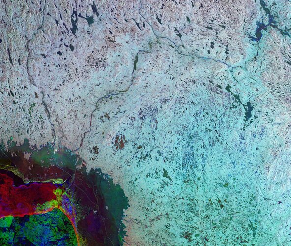 Image:
The Copernicus Sentinel-1 mission takes us over Lapland, the largest and northernmost region of Finland, just in time for Christmas.
Image:
The Copernicus Sentinel-1 mission takes us over Lapland, the largest and northernmost region of Finland, just in time for Christmas.
Aktualizovaný datový web města Brna se zaměří více na otevřená a senzorová data (TZ)
18.12.2020 8:44 GISportal.cz
Koncem listopadu 2018 byl spuštěn komplexní datový web na adrese data.brno.cz. Od té doby ho navštívilo téměř 100 tisíc uživatelů, kteří na něm hledali aplikace, články, analýzy a samotná data. Od 16. 12. 2020 bude na stejné adrese data.brno.cz fungovat nová verze datového webu. Hlavní motivací pro změnu technologie datawebu bylo zvýšení kvality otevřených dat […]
The post Aktualizovaný datový web města Brna se zaměří více na otevřená a senzorová data (TZ) appeared first on GISportal.cz.
OGC seeks Public Comment on revised Abstract Specification: Observations and Measurements
18.12.2020 0:14 GISCafe.com Webcasts-Webinars O&M enables models for the exchange of information describing observation acts and their results. This new revision supports publication …
p. f. 2021 [Knihovna geografie, byTopic]
18.12.2020 0:00 Katedra aplikované geoinformatiky a kartografie Přf UK Vážené čtenářky a čtenáři,dovolte, abychom Vám poděkovali za užívání služeb naší knihovny a popřáli Vám krásné svátky a do nového roku 2021 mnoho úspěchů v osobním i pracovním životě.
Vaše Knihovna geografie PřF UK
Newmont Corporation Adopts Esri's Site Scan for ArcGIS
17.12.2020 19:52 GISCafe.com Webcasts-Webinars Partnership with Esri Provides Drone Mapping Solution to Mine Sites WorldwideREDLANDS, Calif. — (BUSINESS WIRE) — December 17, 2020 …
It's out with the old and in with the new as Geomap becomes Indixio
17.12.2020 19:52 GISCafe.com Webcasts-Webinars In recognition of our growing success over the past 20 years, GeoMap is changing its name to Indixio.SAINT-HUBERT, Quebec, Dec. 17, 2020 — …
Osobní automobil Škoda Fabia Combi
17.12.2020 17:13 ČÚZK /Urady/Katastralni-urady/Katastralni-urady/Katastralni-urad-pro-Karlovarsky-kraj/Nabidky-majetku/Osobni-automobil-Skoda-Fabia-Combi-(1)Osobní automobil Škoda Fabia Combi
17.12.2020 17:13 ČÚZK - předpisy a opatřeníKatastrální úřad pro Karlovarský kraj nabízí nepotřebný majetek k odkupu. Jedná se o
Osobní automobil Škoda Fabia Combi
Loss of Vega flight VV17: Independent Enquiry Commission announces conclusions
17.12.2020 16:51 ESA Observing the EarthPress Release N° 33–2020
On Tuesday, November 17, Arianespace announced the loss of the Vega VV17 mission, which was carrying two payloads, SEOSAT-Ingenio, an Earth-science observation satellite for the European Space Agency (ESA), on behalf of Spain's Center for Development of Industrial Technology (CDTI), and TARANIS for France’s National Centre for Space Studies (CNES). The first three stages functioned nominally until the ignition of the AVUM upper stage, eight minutes after liftoff. At that time, a degraded trajectory was detected, followed by a loss of control of the vehicle and the subsequent loss of the mission.
The Galileo Search and Rescue ground facilities are now upgraded for MEOSAR Full Operational Capability performance
17.12.2020 16:15 European GNSS Agency
The latest upgrades carried out on the SAR/Galileo Local User Terminals of Spain, Cyprus and Norway, earlier in the summer are helping the International COSPAS-SARSAT Programme transition towards MEOSAR completion.
Since the declaration of its Initial Services in December 2016, Galileo has been going from strength to strength, enabling a multitude of new solutions across all market segments. One of the system’s unique capability that is being provided uninterrupted since day one is the Search and Rescue (SAR) service together with the pioneering Galileo Return Link Service. Galileo’s contribution to the Medium Earth Orbit Satellites Search and Rescue System (MEOSAR) managed by the International COSPAS-SARSAT Programme translates into 2000 lives saved per year.
Galileo SAR ground infrastructure supporting the "invisible’’ space segment
From emitting a distress signal to being rescued by emergency responders, the Galileo signals travel 23,000 km from the ground to space and back. When a person in distress activates a Galileo enabled emergency beacon, the Galileo satellites capture the signal and transmit it to three ground stations strategically deployed across Europe called ‘’MEOLUTs’’ (Medium Earth Orbit Local User Terminals) which calculate the precise location of the person in destress. Once the location is determined, it is transmitted to different Mission Control Centres (MCCs) around the world that coordinate the rescue operations. It is only when the MCCs are informed about a potential incident that the Galileo Return Link Service is activated. The user then receives back via the Galileo satellites a confirmation message that their position is known and that help is on the way.
The European MEOLUTs are an integral part of the Galileo SAR ground segment. The three MEOLUTs based in Larnaca (Cyprus), Maspalomas (Spain) and Spitsbergen (Norway) are equipped with 12 measurement antennas (4 antennas per station). For a more robust performance and coverage, the twelve antennas are further coordinated and optimized by a specific facility called MEOLUT Tracking Coordination Facility deployed in Toulouse (France).
MEOLUTs update bringing the Medium Earth Orbit SAR System one step closer to Full Operational Capability (FOC)
The MEOSAR system offers many advantages to SAR operations such as near real-time worldwide coverage and faster detection and localisation services to all end users. To support the transition towards the FOC of the MEOSAR system, the European MEOLUTs were upgraded during the course of the past months and an extensive test campaign was conducted. The results met the operational, performance and functional requirements specified in the COSPAS-SARSAT documentation to allow operations at a MEOSAR FOC performance level. The results were reviewed by a COSPAS-SARSAT dedicated expert working group in October which recommended the approval.
The European MEOLUTs are the first to achieve such level of performance. This millstone coupled with an upgrade at the Mission Control Centers in Cyprus, Spain and Norway will be of big relevance when COSPAS-SARSAT determines MEOSAR’s readiness to Full Operational Capability.

The Larnaca MEOLUT facility has been installed on Makarios Teleport site. It is an isolated area close to the southern shore of Cyprus between the coastal towns of Limassol and Larnaca. It is operated by Cyprus Telecommunication Authorities and is connected to the Cyprus Mission Control Centre.

The Maspalomas MEOLUT facility has been installed on the Maspalomas Space Station site on the Spanish Canary island of Gran Canaria. It is operated by INTA (National Institute for Aerospace Technology in Spain) and is connected to the Spanish Mission Control Centre.

The Spitsbergen MEOLUT facility has been installed on the SvalSat Satellite Ground Station site at the Norwegian archipelago of Svalbard. It is operated by Kongsberg Satellite Services and is connected to the Norwegian Mission Control Centre.
Media note: This feature can be republished without charge provided the European GNSS Agency (GSA) is acknowledged as the source at the top or the bottom of the story. You must request permission before you use any of the photographs on the site. If you republish, we would be grateful if you could link back to the GSA website (http://www.gsa.europa.eu).
The Galileo Search and Rescue ground facilities are now upgraded for MEOSAR Full Operational Capability performance
17.12.2020 16:15 European GNSS AgencyThe latest upgrades carried out on the SAR/Galileo Local User Terminals of Spain, Cyprus and Norway, earlier in the summer are helping the International COSPAS-SARSAT Programme transition towards MEOSAR completion.
Since the declaration of its Initial Services in December 2016, Galileo has been going from strength to strength, enabling a multitude of new solutions across all market segments. One of the system’s unique capability that is being provided uninterrupted since day one is the Search and Rescue (SAR) service together with the pioneering Galileo Return Link Service. Galileo’s contribution to the Medium Earth Orbit Satellites Search and Rescue System (MEOSAR) managed by the International COSPAS-SARSAT Programme translates into 2000 lives saved per year.
Galileo SAR ground infrastructure supporting the "invisible’’ space segment
From emitting a distress signal to being rescued by emergency responders, the Galileo signals travel 23,000 km from the ground to space and back. When a person in distress activates a Galileo enabled emergency beacon, the Galileo satellites capture the signal and transmit it to three ground stations strategically deployed across Europe called ‘’MEOLUTs’’ (Medium Earth Orbit Local User Terminals) which calculate the precise location of the person in destress. Once the location is determined, it is transmitted to different Mission Control Centres (MCCs) around the world that coordinate the rescue operations. It is only when the MCCs are informed about a potential incident that the Galileo Return Link Service is activated. The user then receives back via the Galileo satellites a confirmation message that their position is known and that help is on the way.
The European MEOLUTs are an integral part of the Galileo SAR ground segment. The three MEOLUTs based in Larnaca (Cyprus), Maspalomas (Spain) and Spitsbergen (Norway) are equipped with 12 measurement antennas (4 antennas per station). For a more robust performance and coverage, the twelve antennas are further coordinated and optimized by a specific facility called MEOLUT Tracking Coordination Facility deployed in Toulouse (France).
MEOLUTs update bringing the Medium Earth Orbit SAR System one step closer to Full Operational Capability (FOC)
The MEOSAR system offers many advantages to SAR operations such as near real-time worldwide coverage and faster detection and localisation services to all end users. To support the transition towards the FOC of the MEOSAR system, the European MEOLUTs were upgraded during the course of the past months and an extensive test campaign was conducted. The results met the operational, performance and functional requirements specified in the COSPAS-SARSAT documentation to allow operations at a MEOSAR FOC performance level. The results were reviewed by a COSPAS-SARSAT dedicated expert working group in October which recommended the approval.
The European MEOLUTs are the first to achieve such level of performance. This milestone coupled with an upgrade at the Mission Control Centers in Cyprus, Spain and Norway will be of big relevance when COSPAS-SARSAT determines MEOSAR’s readiness to Full Operational Capability.
The Larnaca MEOLUT facility has been installed on Makarios Teleport site. It is an isolated area close to the southern shore of Cyprus between the coastal towns of Limassol and Larnaca. It is operated by Cyprus Telecommunication Authorities and is connected to the Cyprus Mission Control Centre.
The Maspalomas MEOLUT facility has been installed on the Maspalomas Space Station site on the Spanish Canary island of Gran Canaria. It is operated by INTA (National Institute for Aerospace Technology in Spain) and is connected to the Spanish Mission Control Centre.
The Spitsbergen MEOLUT facility has been installed on the SvalSat Satellite Ground Station site at the Norwegian archipelago of Svalbard. It is operated by Kongsberg Satellite Services and is connected to the Norwegian Mission Control Centre.
Media note: This feature can be republished without charge provided the European GNSS Agency (GSA) is acknowledged as the source at the top or the bottom of the story. You must request permission before you use any of the photographs on the site. If you republish, we would be grateful if you could link back to the GSA website (http://www.gsa.europa.eu).
The Galileo Search and Rescue ground facilities are now upgraded for MEOSAR Full Operational Capability performance
17.12.2020 16:15 European GNSS AgencyThe latest upgrades carried out on the SAR/Galileo Local User Terminals of Spain, Cyprus and Norway, earlier in the summer are helping the International COSPAS-SARSAT Programme transition towards MEOSAR completion.
Since the declaration of its Initial Services in December 2016, Galileo has enabled a multitude of new solutions across all market segments. One of the system’s unique capability that is being provided uninterrupted since day one is the Search and Rescue (SAR) service together with the pioneering Galileo Return Link Service. Galileo’s contribution to the Medium Earth Orbit Satellites Search and Rescue System (MEOSAR) managed by the International COSPAS-SARSAT Programme translates into 2000 lives saved per year.
Galileo SAR ground infrastructure supporting the "invisible’’ space segment
From emitting a distress signal to being rescued by emergency responders, the Galileo signals travel 23,000 km from the ground to space and back. When a person in distress activates a Galileo enabled emergency beacon, the Galileo satellites capture the signal and transmit it to three ground stations strategically deployed across Europe called ‘’MEOLUTs’’ (Medium Earth Orbit Local User Terminals) which calculate the precise location of the person in distress. Once the location is determined, it is transmitted to different Mission Control Centres (MCCs) around the world that coordinate the rescue operations. It is only when the MCCs are informed about a potential incident that the Galileo Return Link Service is activated. The user then receives back via the Galileo satellites a confirmation message that their position is known and that help is on the way.
The European MEOLUTs are an integral part of the Galileo SAR ground segment. The three MEOLUTs based in Larnaca (Cyprus), Maspalomas (Spain) and Spitsbergen (Norway) are equipped with 12 measurement antennas (4 antennas per station). For a more robust performance and coverage, the twelve antennas are further coordinated and optimized by a specific facility called MEOLUT Tracking Coordination Facility deployed in Toulouse (France).
MEOLUTs update bringing the Medium Earth Orbit SAR System one step closer to Full Operational Capability (FOC)
The MEOSAR system offers many advantages to SAR operations such as near real-time worldwide coverage and faster detection and localisation services to all end users. To support the transition towards the FOC of the MEOSAR system, the European MEOLUTs were upgraded during the course of the past months and an extensive test campaign was conducted. The results met the operational, performance and functional requirements specified in the COSPAS-SARSAT documentation to allow operations at a MEOSAR FOC performance level. The results were reviewed by a COSPAS-SARSAT dedicated expert working group in October which recommended the approval.
The European MEOLUTs are the first to achieve such level of performance. This milestone coupled with an upgrade at the Mission Control Centers in Cyprus, Spain and Norway will be of big relevance when COSPAS-SARSAT determines MEOSAR’s readiness to Full Operational Capability.
The Larnaca MEOLUT facility has been installed on Makarios Teleport site. It is an isolated area close to the southern shore of Cyprus between the coastal towns of Limassol and Larnaca. It is operated by Cyprus Telecommunication Authorities and is connected to the Cyprus Mission Control Centre.
The Maspalomas MEOLUT facility has been installed on the Maspalomas Space Station site on the Spanish Canary island of Gran Canaria. It is operated by INTA (National Institute for Aerospace Technology in Spain) and is connected to the Spanish Mission Control Centre.
The Spitsbergen MEOLUT facility has been installed on the SvalSat Satellite Ground Station site at the Norwegian archipelago of Svalbard. It is operated by Kongsberg Satellite Services and is connected to the Norwegian Mission Control Centre.
Media note: This feature can be republished without charge provided the European GNSS Agency (GSA) is acknowledged as the source at the top or the bottom of the story. You must request permission before you use any of the photographs on the site. If you republish, we would be grateful if you could link back to the GSA website (http://www.gsa.europa.eu).
The Galileo Search and Rescue ground facilities are now upgraded for MEOSAR Full Operational Capability performance
17.12.2020 16:15 European GNSS AgencyThe latest upgrades carried out on the SAR/Galileo Local User Terminals of Spain, Cyprus and Norway, earlier in the summer are helping the International COSPAS-SARSAT Programme transition towards MEOSAR completion.
Since the declaration of its Initial Services in December 2016, Galileo has been going from strength to strength, enabling a multitude of new solutions across all market segments. One of the system’s unique capability that is being provided uninterrupted since day one is the Search and Rescue (SAR) service together with the pioneering Galileo Return Link Service. Galileo’s contribution to the Medium Earth Orbit Satellites Search and Rescue System (MEOSAR) managed by the International COSPAS-SARSAT Programme translates into 2000 lives saved per year.
Galileo SAR ground infrastructure supporting the "invisible’’ space segment
From emitting a distress signal to being rescued by emergency responders, the Galileo signals travel 23,000 km from the ground to space and back. When a person in distress activates a Galileo enabled emergency beacon, the Galileo satellites capture the signal and transmit it to three ground stations strategically deployed across Europe called ‘’MEOLUTs’’ (Medium Earth Orbit Local User Terminals) which calculate the precise location of the person in destress. Once the location is determined, it is transmitted to different Mission Control Centres (MCCs) around the world that coordinate the rescue operations. It is only when the MCCs are informed about a potential incident that the Galileo Return Link Service is activated. The user then receives back via the Galileo satellites a confirmation message that their position is known and that help is on the way.
The European MEOLUTs are an integral part of the Galileo SAR ground segment. The three MEOLUTs based in Larnaca (Cyprus), Maspalomas (Spain) and Spitsbergen (Norway) are equipped with 12 measurement antennas (4 antennas per station). For a more robust performance and coverage, the twelve antennas are further coordinated and optimized by a specific facility called MEOLUT Tracking Coordination Facility deployed in Toulouse (France).
MEOLUTs update bringing the Medium Earth Orbit SAR System one step closer to Full Operational Capability (FOC)
The MEOSAR system offers many advantages to SAR operations such as near real-time worldwide coverage and faster detection and localisation services to all end users. To support the transition towards the FOC of the MEOSAR system, the European MEOLUTs were upgraded during the course of the past months and an extensive test campaign was conducted. The results met the operational, performance and functional requirements specified in the COSPAS-SARSAT documentation to allow operations at a MEOSAR FOC performance level. The results were reviewed by a COSPAS-SARSAT dedicated expert working group in October which recommended the approval.
The European MEOLUTs are the first to achieve such level of performance. This millstone coupled with an upgrade at the Mission Control Centers in Cyprus, Spain and Norway will be of big relevance when COSPAS-SARSAT determines MEOSAR’s readiness to Full Operational Capability.
The Larnaca MEOLUT facility has been installed on Makarios Teleport site. It is an isolated area close to the southern shore of Cyprus between the coastal towns of Limassol and Larnaca. It is operated by Cyprus Telecommunication Authorities and is connected to the Cyprus Mission Control Centre.
The Maspalomas MEOLUT facility has been installed on the Maspalomas Space Station site on the Spanish Canary island of Gran Canaria. It is operated by INTA (National Institute for Aerospace Technology in Spain) and is connected to the Spanish Mission Control Centre.
The Spitsbergen MEOLUT facility has been installed on the SvalSat Satellite Ground Station site at the Norwegian archipelago of Svalbard. It is operated by Kongsberg Satellite Services and is connected to the Norwegian Mission Control Centre.
Media note: This feature can be republished without charge provided the European GNSS Agency (GSA) is acknowledged as the source at the top or the bottom of the story. You must request permission before you use any of the photographs on the site. If you republish, we would be grateful if you could link back to the GSA website (http://www.gsa.europa.eu).
Skydio and Arris Revolutionize Drone Design and Manufacturing
17.12.2020 16:03 GISCafe.com Webcasts-Webinars Silicon Valley innovators accelerate next-gen UAVs fusing AI-powered autonomy with breakthrough composites manufacturingSAN FRANCISCO — …
HawkEye 360's Next-Gen Satellites Ship to Cape Canaveral for Launch
17.12.2020 16:03 GISCafe.com Webcasts-Webinars January satellite launch will initiate build-out of most advanced commercial RF sensing constellationHERNDON, Va., Dec. 17, 2020 — …
Sagetech Avionics and Hover, Inc. Partner on Detect and Avoid Solution for Unmanned Aircraft
17.12.2020 16:03 GISCafe.com Webcasts-Webinars Sagetech technologies, combined with a Hover, Inc. embedded computer, will serve as core onboard detect and avoid components for UAV OEMsWHITE …
Přerušení provozu DP a WSDP v pátek 18.12.2020 od 20:00 do cca 20:30.
17.12.2020 15:38 ČÚZK - předpisy a opatření Vážení uživatelé,oznamujeme, že v pátek 18.12.2020 od 20:00 bude z provozních důvodů zcela přerušen provoz Dálkového přístupu i Webových služeb dálkového přístupu. Obnovení provozu předpokládáme v cca 20:30 hodin. V rámci přerušení provozu budou instalovány pouze opravy drobných chyb. Nebude instalována žádná nová funkčnost.
Za komplikace tímto způsobené se omlouváme a děkujeme za pochopení.
Přerušení provozu DP a WSDP v pátek 18.12.2020 od 20:00 do cca 20:30.
17.12.2020 15:38 ČÚZK /Aplikace-DP-do-KN/Aplikace-DP-do-KN/Archiv-DP/309419Přerušení provozu DP a WSDP v pátek 18.12.2020 od 20:00 do cca 20:30.
17.12.2020 15:38 Dálkový přístup k údajům KN ČR Vážení uživatelé,oznamujeme, že v pátek 18.12.2020 od 20:00 bude z provozních důvodů zcela přerušen provoz Dálkového přístupu i Webových služeb dálkového přístupu. Obnovení provozu předpokládáme v cca 20:30 hodin. V rámci přerušení provozu budou instalovány pouze opravy drobných chyb. Nebude instalována žádná nová funkčnost.
Za komplikace tímto způsobené se omlouváme a děkujeme za pochopení.
EU investment is key to a vibrant downstream space market
17.12.2020 14:45 European GNSS Agency
A session on Horizon 2020 success stories, held on the final day of European Space Week, highlighted some of the innovative projects that took advantage of EU H2020 funding to develop ideas leveraging Galileo, EGNOS and Copernicus, or synergies between the programmes, to produce products for the market. The session included some valuable advice for anyone thinking about applying for funding.
Kicking off the session, GSA Executive Director Rodrigo da Costa noted the importance of the downstream space sector in terms of job and value creation. “Innovation and the increasing volume of data and services available, are contributing to the sustainable growth of EU start-ups, SMEs and companies,” he said, adding that success stories from Horizon 2020 were proof that EU investment support is essential for innovation.
Looking to the future, da Costa said that the GSA would continue its work with Horizon Europe, building on the successes of Horizon 2020. “The next period will bring additional investment and instruments to the downstream space segment,” he said.
Read this: Let us have your feedback on Galileo/EGNOS – User satisfaction survey launched
The representative from the Directorate-General for Defence Industry and Space (DG DEFIS) also noted that the downstream sector is an area of growth where many jobs are created, adding that tomorrow’s space applications would pave the way for a whole range of innovative applications for European industry. He also introduced the EUR 1-billion CASSINI (Competitive Space Start-ups for INnovatIon) initiative, which aims to expand the number of start-ups creating businesses based on innovative EU space technologies.
The voice of experience
A number of successful Horizon 2020 projects gave their advice to other projects considering applying for EU support. The need to put together a strong team was something that many of the successful projects advised. Isabel Botey from the DCS4COP project said that it is necessary to gather a strong team of experts, and have a strong vision and an easy to understand strategy. “Talk to customers. They are the best consultants for a successful business,” she said.
Ernst Pfeiffer from the Large European Antenna project (Project LEA) advised projects to apply for funding only if its fits exactly with their project’s specialisation. “Select your team carefully and involve your national contact point for advice and recommendations,” he said. Linda Moser from the EcoLaSS project advised applicants to have a strong vision that goes beyond tomorrow’s state of the art and meets societal challenges. She said that, as projects can last for a long time, it is important to ensure that the results will still be relevant by the project’s end.
And this: High accuracy and synergies in focus at UCP
Raúl Arnau Prieto from Greenpatrol advised applicants to prepare their proposal well in advance and match their technical challenges to the scope of the call, while Pedro Russo from SpaceEU advised to build a consortium that truly cares about the challenge that the project addresses.
Winding up the session, MEP Cristophe Grudler noted that the projects presented during the session showed how dynamic the EU space sector is, and proved that EU investment is key to support competitiveness and innovation in the EU space industry.
Media note: This feature can be republished without charge provided the European GNSS Agency (GSA) is acknowledged as the source at the top or the bottom of the story. You must request permission before you use any of the photographs on the site. If you republish, we would be grateful if you could link back to the GSA website (http://www.gsa.europa.eu).
EU investment is key to a vibrant downstream space market
17.12.2020 14:45 European GNSS AgencyA session on Horizon 2020 success stories, held on the final day of European Space Week, highlighted some of the innovative projects that took advantage of EU H2020 funding to develop ideas leveraging Galileo, EGNOS and Copernicus, or synergies between the programmes, to produce products for the market. The session included some valuable advice for anyone thinking about applying for funding.
Kicking off the session, GSA Executive Director Rodrigo da Costa noted the importance of the downstream space sector in terms of job and value creation. “Innovation and the increasing volume of data and services available, are contributing to the sustainable growth of EU start-ups, SMEs and companies,” he said, adding that success stories from Horizon 2020 were proof that EU investment support is essential for innovation.
Looking to the future, da Costa said that the GSA would continue its work with Horizon Europe, building on the successes of Horizon 2020. “The next period will bring additional investment and instruments to the downstream space segment,” he said.
Read this: Let us have your feedback on Galileo/EGNOS – User satisfaction survey launched
The representative from the Directorate-General for Defence Industry and Space (DG DEFIS) also noted that the downstream sector is an area of growth where many jobs are created, adding that tomorrow’s space applications would pave the way for a whole range of innovative applications for European industry. He also introduced the EUR 1-billion CASSINI (Competitive Space Start-ups for INnovatIon) initiative, which aims to expand the number of start-ups creating businesses based on innovative EU space technologies.
The voice of experience
A number of successful Horizon 2020 projects gave their advice to other projects considering applying for EU support. The need to put together a strong team was something that many of the successful projects advised. Isabel Botey from the DCS4COP project said that it is necessary to gather a strong team of experts, and have a strong vision and an easy to understand strategy. “Talk to customers. They are the best consultants for a successful business,” she said.
Ernst Pfeiffer from the Large European Antenna project (Project LEA) advised projects to apply for funding only if its fits exactly with their project’s specialisation. “Select your team carefully and involve your national contact point for advice and recommendations,” he said. Linda Moser from the EcoLaSS project advised applicants to have a strong vision that goes beyond tomorrow’s state of the art and meets societal challenges. She said that, as projects can last for a long time, it is important to ensure that the results will still be relevant by the project’s end.
And this: High accuracy and synergies in focus at UCP
Raúl Arnau Prieto from Greenpatrol advised applicants to prepare their proposal well in advance and match their technical challenges to the scope of the call, while Pedro Russo from SpaceEU advised to build a consortium that truly cares about the challenge that the project addresses.
Winding up the session, MEP Cristophe Grudler noted that the projects presented during the session showed how dynamic the EU space sector is, and proved that EU investment is key to support competitiveness and innovation in the EU space industry.
Media note: This feature can be republished without charge provided the European GNSS Agency (GSA) is acknowledged as the source at the top or the bottom of the story. You must request permission before you use any of the photographs on the site. If you republish, we would be grateful if you could link back to the GSA website (http://www.gsa.europa.eu).
Mountains of snow
17.12.2020 14:20 ESA Observing the Earth Image:
Heavy snowfall in the Alps has been recorded over the past weeks. The Copernicus Sentinel-3 mission captured this image of the snow-covered Alps on 14 December.
Image:
Heavy snowfall in the Alps has been recorded over the past weeks. The Copernicus Sentinel-3 mission captured this image of the snow-covered Alps on 14 December.
PF 2021
17.12.2020 12:44 TopGis Klidné prožití vánočních svátků, mnoho štěstí, zdraví, osobní spokojenosti a pracovních úspěchů v novém roce 2021 přeje TopGis.Nový systém PhaseOne PAS 880 umí 2,5 cm na pixel. Zvládne pořídit i šikmé snímky
17.12.2020 12:07 ZeměměřičFirma Phase One Industrial, dánský producent řešení pro letecké snímkování, představila novou letecký velkoformátový snímkovací systém PAS 880. Systém obsahuje 280 Mpx nadirovou (svislou) kameru a čtyři 150 MPx kamery pro šikmé snímkování, které současně snímají fotogrammetrické 2D a 3D digitální snímky. S rychlostí dva snímky za sekundu systém PAS 880 pokrývá široký snímkový pás o šířce 20 000 […]
The post Nový systém PhaseOne PAS 880 umí 2,5 cm na pixel. Zvládne pořídit i šikmé snímky appeared first on Zeměměřič.
Nový systém PhaseOne PAS 880 umí 2,5 cm na pixel. Zvládne pořídit i šikmé snímky
17.12.2020 12:07 ZeměměřičFirma Phase One Industrial, dánský producent řešení pro letecké snímkování, představila novou letecký velkoformátový snímkovací systém PAS 880. Systém obsahuje 280 Mpx nadirovou (svislou) kameru a čtyři 150 MPx kamery pro šikmé snímkování, které současně snímají fotogrammetrické 2D a 3D digitální snímky. S rychlostí dva snímky za sekundu systém PAS 880 pokrývá široký snímkový pás o šířce 20 000 […]
The post Nový systém PhaseOne PAS 880 umí 2,5 cm na pixel. Zvládne pořídit i šikmé snímky appeared first on Zeměměřič.
20201217 - GaKO 12/2020
17.12.2020 11:43 ČÚZK - předpisy a opatření Český úřad zeměměřický a katastrální zveřejnil novou aktualitu: Aktuální číslo Geodetického a kartografického obzoru (12/2020) je k dispozici ke stažení.20201217 - GaKO 12/2020
17.12.2020 11:43 ČÚZK - předpisy a opatření Český úřad zeměměřický a katastrální zveřejnil novou aktualitu: Aktuální číslo Geodetického a kartografického obzoru (12/2020) je k dispozici ke stažení.20201217 - GaKO 12/2020
17.12.2020 11:43 ČÚZK - aktuality v resortu Aktuální číslo Geodetického a kartografického obzoru (12/2020) je k dispozici ke stažení.úřední hodiny
17.12.2020 11:06 ČÚZK - předpisy a opatření Zeměměřický a katastrální inspektorát v Pardubicích zveřejnil novou aktualitu: změna úředních hodinVážení klienti,
úřední hodiny podatelny a pro veřejnost na Zeměměřickém a katastrálním inspektorátu v Pardubicích budou s účinností od 21. 12. 2020 upraveny takto:
21. 12. 2020 - 8,00 h do 13,00 h
23. 12. 2020 - 8,00 h do 13,00 h
28. 12. 2020 - 8,00 h do 13,00 h
30. 12. 2020 - 8,00 h do 13,00 h.
Je upřednostňován písemný, elektronický či telefonický kontakt před kontaktem osobním.
Děkujeme za pochopení.
úřední hodiny
17.12.2020 11:06 ČÚZK /Urady/Zememericke-a-katastralni-inspektoraty/Zememericke-a-katastralni-inspektoraty/Zememericky-a-katastralni-inspektorat-v-Pardubicic/O-uradu/Aktuality/uredni-hodinyúřední hodiny
17.12.2020 11:06 ČÚZK - předpisy a opatření Zeměměřický a katastrální inspektorát v Pardubicích zveřejnil novou aktualitu: změna úředních hodinVážení klienti,
úřední hodiny podatelny a pro veřejnost na Zeměměřickém a katastrálním inspektorátu v Pardubicích budou s účinností od 21. 12. 2020 upraveny takto:
pondělí 21. 12. 2020 od 8,00 h do 13,00 h
středa 23. 12. 2020 od 8,00 h do 13,00 h
pondělí 28. 12. 2020 od 8,00 h do 13,00 h
středa 30. 12. 2020 od 8,00 h do 13,00 h.
Je upřednostňován písemný, elektronický či telefonický kontakt před kontaktem osobním.
Děkujeme za pochopení.
úřední hodiny
17.12.2020 11:06 ČÚZK - předpisy a opatření Zeměměřický a katastrální inspektorát v Pardubicích zveřejnil novou aktualitu: změna úředních hodinVážení klienti,
úřední hodiny podatelny a pro veřejnost na Zeměměřickém a katastrálním inspektorátu v Pardubicích budou s účinností od 21. 12. 2020 upraveny takto:
pondělí 21. 12. 2020 od 8,00 h do 13,00 h
středa 23. 12. 2020 od 8,00 h do 13,00 h
pondělí 28. 12. 2020 od 8,00 h do 13,00 h
středa 30. 12. 2020 od 8,00 h do 13,00 h.
Je upřednostňován písemný, elektronický či telefonický kontakt před kontaktem osobním.
Děkujeme za pochopení.
Cestmistrovství
17.12.2020 11:00 Středočeský kraj Byla přidána nová interaktivní mapa Cestmistrovství. Mapa zobrazuje rozdělení kraje na jednotlivá cestmistrovství a zároveň odkazuje na podrobné mapy jednotlivých cestmistrovství. Zdrojem dat podrobných map je Silniční databanka, jejímž poskytovatelem je Ředitelství silnic a dálnic ČR, a vybraná data z datové sady ZABAGED, jejímž poskytovatelem je Zeměměřický úřad. Aktualizaci vlastní vrstvy hranice Cestmistrovství zajišťuje Odbor dopravy. Podrobné mapy mohou využívat nejen zástupci příspěvkových organizací, např. Krajská správa údržby a silnic, ale kdokoliv, kdo se o tuto problematiku zajímá. Interaktivní mapu vč. podrobných map připravil Odbor informatiky / GIS.Nová verzia Trimble Access 2020.20
17.12.2020 10:19 Geotronics.sk Tento týždeň vyšla nová verzia softvéru Trimble Access pre kontrolné jednotky Trimble TSC7 s OS Windows 10, TDC600 a TCU5 s OS Android. Podrobný popis nových funkcií a opráv chýb starého softvéru nájdete TU: Zmena veľkosti mapy a formulára Teraz môžete pomocou jednoduchého ovládacieho prvku jazdca zmeniť veľkosť ľubovoľného formulára, ktorý sa zobrazí [...]Cholera outbreaks predicted using climate data and AI
17.12.2020 9:40 ESA Observing the Earth
Climate data taken from Earth orbiting satellites, combined with machine learning techniques, are helping to better predict outbreaks of cholera and potentially save lives.
Odborný referent/vrchní referent – zápisy v řízení V a Z na Katastrálním pracovišti Karviná
17.12.2020 8:59 ČÚZK - volná místa Katastrální úřad pro Moravskoslezský kraj Katastrální pracoviště Karviná vypisuje výběrové řízení na místo Odborný referent/vrchní referent – zápisy v řízení V a Z na Katastrálním pracovišti KarvináOdborný referent/vrchní referent – zápisy v řízení V a Z na Katastrálním pracovišti Karviná
17.12.2020 8:59 ČÚZK /Urady/Katastralni-urady/Katastralni-urady/Katastralni-urad-pro-Moravskoslezsky-kraj/Uredni-deska/Oznameni-a-jina-uredni-sdeleni/Volna-mista/DMS/Odborny-referent-vrchni-referent-–-zapisy-v-rizeniOdborný referent/vrchní referent – zápisy v řízení V a Z na Katastrálním pracovišti Karviná
17.12.2020 8:59 ČÚZK - předpisy a opatření Katastrální úřad pro Moravskoslezský kraj Katastrální pracoviště Karvinávypisuje výběrové řízení na místo
Odborný referent/vrchní referent – zápisy v řízení V a Z na Katastrálním pracovišti Karviná
Leica Geosystems introduces one app for all terrestrial laser scanning portfolio
17.12.2020 1:03 GISCafe.com Webcasts-Webinars Award-winning mobile-device app, Leica Cyclone FIELD 360 now expands in-field data acquisition and visualisation for all Leica Geosystems 3D …Bentley Systems Appoints Artem Avedian General Manager of Business Operations in Russia and the CIS
17.12.2020 1:00 Bentley SystemsEXTON, Pa. – December 17, 2020 – Bentley Systems, Incorporated (Nasdaq: BSY), the infrastructure engineering software company, announced that it has appointed Artem Avedian as general manager of business operations in Russia and the Commonwealth of Independent States. In this role, he is responsible for Bentley’s regional sales strategy and business growth development. Based in Moscow, Avedian reports to Mattias Hemmingsson, regional director for Nordic and Baltic countries, as well as Russia and the CIS.
“I am excited to welcome Artem to his new role of general manager for Bentley Russia and the CIS,” Hemmingsson said. “In the region over the past few years, Bentley has seen an increasing interest in the integrated, multidiscipline solutions that it offers. I am convinced that Artem’s long professional experience in the market, his great leadership skills, and his ability to promote our company’s values will ensure the successful execution of Bentley’s business strategy and drive continued growth in the region.”
“I am excited to be joining a team of dedicated professionals that will solve complex and important tasks for advancing the modernization and digitalization of industrial, transport, and urban infrastructure,” Avedian said. “I am also looking forward to helping our users in Russia and the CIS implement modern design solutions and innovative technologies developed by Bentley Systems. I am sure that my colleagues, our users, and our partners will overcome the challenges we face and achieve successful results in all ongoing and future projects.”
Avedian has over 20 years of experience at management-level positions in business development and sales with both Russian and international companies. Prior to this appointment, he served as deputy CEO and sales director of CADFEM CIS, an authorized distributor of Ansys Inc. in Russia and the CIS, where he contributed to the company’s sales and revenue growth. He also worked for General Electric, Microsoft, and Dassault Systèmes in Russia and the CIS.
Avedian earned a master’s degree in aircraft design, construction, and production, as well as a Ph.D. in computer-aided design from the Moscow Aviation Institute.

Caption: Artem Avedian has joined Bentley Systems as general manager of business operations in Russia and the Commonwealth of Independent States.
About Bentley Systems
Bentley Systems (Nasdaq: BSY) is the infrastructure engineering software company. We provide innovative software to advance the world’s infrastructure – sustaining both the global economy and environment. Our industry-leading software solutions are used by professionals, and organizations of every size, for the design, construction, and operations of roads and bridges, rail and transit, water and wastewater, public works and utilities, buildings and campuses, and industrial facilities. Our offerings include MicroStation-based applications for modeling and simulation, ProjectWise for project delivery, AssetWise for asset and network performance, and the iTwin platform for infrastructure digital twins. Bentley Systems employs more than 4,000 colleagues and generates annual revenues of more than $700 million in 172 countries.
© 2020 Bentley, the Bentley logo, AssetWise, iTwin, MicroStation, and ProjectWise are either registered or unregistered trademarks or service marks of Bentley Systems, Incorporated or one of its direct or indirect wholly owned subsidiaries. All other brands and product names are trademarks of their respective owners.
Bentley Systems Appoints Artem Avedian General Manager of Business Operations in Russia and the CIS
17.12.2020 1:00 Bentley SystemsEXTON, Pa. – December 17, 2020 – Bentley Systems, Incorporated (Nasdaq: BSY), the infrastructure engineering software company, announced that it has appointed Artem Avedian as general manager of business operations in Russia and the Commonwealth of Independent States. In this role, he is responsible for Bentley’s regional sales strategy and business growth development. Based in Moscow, Avedian reports to Mattias Hemmingsson, regional director for Nordic and Baltic countries, as well as Russia and the CIS.
“I am excited to welcome Artem to his new role of general manager for Bentley Russia and the CIS,” Hemmingsson said. “In the region over the past few years, Bentley has seen an increasing interest in the integrated, multidiscipline solutions that it offers. I am convinced that Artem’s long professional experience in the market, his great leadership skills, and his ability to promote our company’s values will ensure the successful execution of Bentley’s business strategy and drive continued growth in the region.”
“I am excited to be joining a team of dedicated professionals that will solve complex and important tasks for advancing the modernization and digitalization of industrial, transport, and urban infrastructure,” Avedian said. “I am also looking forward to helping our users in Russia and the CIS implement modern design solutions and innovative technologies developed by Bentley Systems. I am sure that my colleagues, our users, and our partners will overcome the challenges we face and achieve successful results in all ongoing and future projects.”
Avedian has over 20 years of experience at management-level positions in business development and sales with both Russian and international companies. Prior to this appointment, he served as deputy CEO and sales director of CADFEM CIS, an authorized distributor of Ansys Inc. in Russia and the CIS, where he contributed to the company’s sales and revenue growth. He also worked for General Electric, Microsoft, and Dassault Systèmes in Russia and the CIS.
Avedian earned a master’s degree in aircraft design, construction, and production, as well as a Ph.D. in computer-aided design from the Moscow Aviation Institute.

Caption: Artem Avedian has joined Bentley Systems as general manager of business operations in Russia and the Commonwealth of Independent States.
About Bentley Systems
Bentley Systems (Nasdaq: BSY) is the infrastructure engineering software company. We provide innovative software to advance the world’s infrastructure – sustaining both the global economy and environment. Our industry-leading software solutions are used by professionals, and organizations of every size, for the design, construction, and operations of roads and bridges, rail and transit, water and wastewater, public works and utilities, buildings and campuses, and industrial facilities. Our offerings include MicroStation-based applications for modeling and simulation, ProjectWise for project delivery, AssetWise for asset and network performance, and the iTwin platform for infrastructure digital twins. Bentley Systems employs more than 4,000 colleagues and generates annual revenues of more than $700 million in 172 countries.
© 2020 Bentley, the Bentley logo, AssetWise, iTwin, MicroStation, and ProjectWise are either registered or unregistered trademarks or service marks of Bentley Systems, Incorporated or one of its direct or indirect wholly owned subsidiaries. All other brands and product names are trademarks of their respective owners.
Nová verze softwaru Trimble Business Center přichází s možností předplatného
16.12.2020 23:03 ZeměměřičTrimble Business Center je univerzální software pro zpracování geodat. Verze 5.40, kterou firma Trimble představila 14. prosince 2020, přichází s novými funkcemi, například Ne každý uživatel však chce nebo může zaplatit za software v celku, proto se u nové verze softwaru objevila možnost předplatného, podobně jako si můžete objednat a používat software od Autodesku, Microsoftu nebo třeba od Adobe. Předplatným […]
The post Nová verze softwaru Trimble Business Center přichází s možností předplatného appeared first on Zeměměřič.
Nedostupnost pracoviště
16.12.2020 20:14 ČÚZK /Urady/Katastralni-urady/Katastralni-urady/Katastralni-urad-pro-Plzensky-kraj/Katastralni-pracoviste/KP-Klatovy/O-uradu/Aktuality/Nedostupnost-pracovisteNedostupnost pracoviště
16.12.2020 20:14 ČÚZK - předpisy a opatření Katastrální úřad pro Plzeňský kraj - Katastrální pracoviště Klatovy zveřejnil novou aktualitu: Ve čvrtek 17. 12. 2020 od 14:00 do cca 17:00 dojde k odstávce dodávky el. proudu v celé budově KP Klatovy, dodavatel el. proudu ČEZ Distribuce bude provádět optimalizaci odběrného místa. V této době nebude pracoviště Klatovy dostupné.Skydio Announces The Availability of New Enterprise Software For Skydio 2TM and a new Training Program for Certified Skydio Pilots
16.12.2020 19:57 GISCafe.com Webcasts-Webinars Demonstrates swift market traction as the company continues accelerated product roadmap and training for enterprise and public sectorREDWOOD CITY, …
May Mobility Selects Velodyne Lidar as Long-Range Lidar Provider
16.12.2020 19:57 GISCafe.com Webcasts-Webinars Velodyne Provides Alpha Prime™ Sensors for Self-Driving ShuttlesSAN JOSE, Calif. — (BUSINESS WIRE) — December 16, 2020 …
XAG Unveiled New-gen Agricultural Drone and Ground Robots, to Open the Age of Unmanned Farms
16.12.2020 19:57 GISCafe.com Webcasts-Webinars GUANGZHOU, China, Dec. 16, 2020 — (PRNewswire) — XAG has launched a new series of smart agri-tech at its annual conference (XAAC 2020) …HawkEye 360 Supporting RF GEOINT Pilot Program for the National Geospatial-Intelligence Agency
16.12.2020 18:19 GISCafe.com Webcasts-Webinars Pilot program explores how commercial RF geospatial data can augment NGA and United States combatant command intelligence activitiesHERNDON, Va., …
Úřední hodiny dne 23. 12. 2020
16.12.2020 14:50 ČÚZK - předpisy a opatření Katastrální úřad pro Liberecký kraj - Katastrální pracoviště Česká Lípa zveřejnil novou aktualitu: Ve středu dne 23. 12. 2020 budou úřední hodiny Katastrálního pracoviště Česká Lípa od 8 do 15 hodin.Dne 31. 12. 2020 bude sběrný box pro příjem podání přístupný od 8 do 12 hodin.
Děkujeme za pochopení.
Úřední hodiny dne 23. 12. 2020
16.12.2020 14:50 ČÚZK /Urady/Katastralni-urady/Katastralni-urady/Katastralni-urad-pro-Liberecky-kraj/Katastralni-pracoviste/KP-Ceska-Lipa/O-uradu/Aktuality/Uredni-hodiny-dne-23-12-2020
Nové číslo GaKO
16.12.2020 14:35
ÚGKK SR
Nové číslo časopisu Geodetického a Kartografického Obzoru 12/2020
GaKO 12/2020
16.12.2020 14:09 GaKO GaKO 12/2020 ZIMOVÁ, R.: Diskusní platforma Nemoforum – dvacet let činnostiÚřední hodiny.
16.12.2020 13:18 ČÚZK - předpisy a opatření Katastrální úřad pro Liberecký kraj - Katastrální pracoviště Liberec zveřejnil novou aktualitu: Dne 23.12.2020 budou úřední hodiny 8:00 – 15:00Poplatky plaťte, prosím, kartou nebo převodem (popřípadě kolky), na konci roku může dojít k omezení příjmu hotovosti.
Podání se zasílají poštou. Osobně přinesená vkládejte do schránky u vchodu - veškeré žádosti včetně návrhů na vklad. Uveďte eMail, zašleme Vám platební údaje a potvrzení o převzetí (např. kopii s podacím razítkem). Vkládejte v uzavřené obálce max. A4, vybíráme průběžně každý den Po, St do 17, Út, Čt do 14, v pátek do 12 hod., 31.12.2020 do 11 hod.
Zkontrolujte, zda je návrh na vklad podepsaný.
Podrobnosti zde.
Návrh na vklad: aplikace.
Podrobnosti o elektronickém podání.
Úřední hodiny.
16.12.2020 13:18 ČÚZK /Urady/Katastralni-urady/Katastralni-urady/Katastralni-urad-pro-Liberecky-kraj/Katastralni-pracoviste/KP-Liberec/O-uradu/Aktuality/Uredni-hodinyÚřední hodiny.
16.12.2020 13:18 ČÚZK - předpisy a opatření Katastrální úřad pro Liberecký kraj - Katastrální pracoviště Liberec zveřejnil novou aktualitu: Dne 23.12.2020 budou úřední hodiny 8:00 – 15:00Poplatky plaťte, prosím, kartou nebo převodem (popřípadě kolky), na konci roku může dojít k omezení příjmu hotovosti.
Podání se zasílají poštou. Osobně přinesená vkládejte do schránky u vchodu - veškeré žádosti včetně návrhů na vklad. Uveďte eMail, zašleme Vám platební údaje a potvrzení o převzetí (např. kopii s podacím razítkem). Vkládejte v uzavřené obálce max. A4, vybíráme průběžně každý den Po, St do 17, Út, Čt do 14, v pátek do 12 hod., 31.12.2020 do 11 hod.
Zkontrolujte, zda je návrh na vklad podepsaný.
Podrobnosti zde.
Návrh na vklad: aplikace.
Podrobnosti o elektronickém podání.
úřední hodiny v 51. až 53. týdnu roku 2020
16.12.2020 10:36 ČÚZK - předpisy a opatření Katastrální úřad pro Liberecký kraj - Katastrální pracoviště Frýdlant zveřejnil novou aktualitu: Úřední hodiny mezi vánočními svátky 2020úřední hodiny v 51. až 53. týdnu roku 2020
16.12.2020 10:36 ČÚZK /Urady/Katastralni-urady/Katastralni-urady/Katastralni-urad-pro-Liberecky-kraj/Katastralni-pracoviste/KP-Frydlant/O-uradu/Aktuality/uredni-hodiny-v-51-az-53-tydnu-roku-2020úřední hodiny v 51. až 53. týdnu roku 2020
16.12.2020 10:36 ČÚZK - předpisy a opatření Katastrální úřad pro Liberecký kraj - Katastrální pracoviště Frýdlantzveřejnil novou aktualitu: Úřední hodiny mezi vánočními svátky 2020
Děkujeme všem zákazníků
16.12.2020 10:16 Adeon![]() Děkujeme všem zákazníkům, přejeme hezké svátky a těšíme se na kontakty v novém roce.
Děkujeme všem zákazníkům, přejeme hezké svátky a těšíme se na kontakty v novém roce.
Long-term permafrost record details Arctic thaw
16.12.2020 10:00 ESA Observing the Earth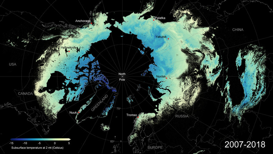
Frozen Arctic soils are set to release vast amounts of greenhouse gases to the atmosphere as they continue to thaw in coming decades. Despite concerns that this will fuel future global warming, the scale and speed of this important climate process remain uncertain. To help address this knowledge gap, ESA-funded researchers have developed and released a new permafrost dataset – the longest, satellite-derived permafrost record currently available.
End-Of-The-Year slevová
16.12.2020 9:52 Adeon![]() End-Of-The-Year slevová akce na nejoblíběnější produkty značky CGS.
End-Of-The-Year slevová akce na nejoblíběnější produkty značky CGS.
změna úředních hodin
16.12.2020 9:36 ČÚZK - předpisy a opatření Katastrální úřad pro Liberecký kraj zveřejnil novou aktualitu: Ve středu dne 23. 12. 2020 budou úřední hodiny katastrálního úřadu a všech jeho pracovišť od 8 do 15 hodin. Děkujeme za pochopení.změna úředních hodin
16.12.2020 9:36 ČÚZK /Urady/Katastralni-urady/Katastralni-urady/Katastralni-urad-pro-Liberecky-kraj/O-uradu/Aktuality/zmena-urednich-hodin-(3)ÚH 23.12.2020
16.12.2020 8:59 ČÚZK - předpisy a opatření Katastrální úřad pro Jihočeský kraj zveřejnil novou aktualitu: UPOZORNĚNÍVe středu dne 23.12.2020 budou na všech katastrálních pracovištích Katastrálního úřadu pro Jihočeský kraj úřední hodiny v omezeném rozsahu od 8 do 14 hodin.
ÚH 23.12.2020
16.12.2020 8:59 ČÚZK /Urady/Katastralni-urady/Katastralni-urady/Katastralni-urad-pro-Jihocesky-kraj/O-uradu/Aktuality/UH-23-12-2020Upozornění
16.12.2020 8:30 ČÚZK /Urady/Katastralni-urady/Katastralni-urady/Katastralni-urad-pro-Plzensky-kraj/O-uradu/Aktuality/Upozorneni-(2)Upozornění
16.12.2020 8:30 ČÚZK - předpisy a opatření Katastrální úřad pro Plzeňský kraj zveřejnil novou aktualitu: Katastrální úřad pro Plzeňský kraj od 21. 12. 2020 upravuje úřední hodiny katastrálních pracovišť.Ušetřete 20% na AutoCADu, AutoCADu LT a Revitu LT
16.12.2020 1:00 CAD Studio Ušetřete 20 % na Vašem novém CAD/BIM software - platí jen 2 dny, do 17.12. Váš nový CAD či BIM software Autodesk si nyní můžete pořídit levněji. V rámci krátké 2denní slevové promo akce můžete zakoupit o 20 % zvýhodněné 3leté subscription licence ...Autodesk ohlásil již tra
16.12.2020 0:00 Adeon Autodesk ohlásil již tradiční časově omezenou slevu až 20% na vybrané CAD produkty.
Knihovna geografie o vánočních prázdninách [Knihovna geografie, byTopic]
16.12.2020 0:00 Katedra aplikované geoinformatiky a kartografie Přf UK V období od 21.12.2020 do 1.1.2021 bude knihovna zcela uzavřena.Doubravice nad Svitavou a Kuničky se pyšní novou polní cestou
16.12.2020 0:00 Státní pozemkový úřad Pobočka Blansko Krajského pozemkového úřadu pro Jihomoravský kraj v roce 2020 dokončila stavbu polních cest s příkopy a rigoly v katastrálních územích Doubravice nad Svitavou a Kuničky.Swift Navigation Introduces a PCIe Product to Bring High-Precision GNSS to Industrial, Last-Mile and IoT Platforms
15.12.2020 20:24 GISCafe.com Webcasts-Webinars SAN FRANCISCO, Dec. 15, 2020 (GLOBE NEWSWIRE) -- Swift Navigation, a San Francisco-based tech firm redefining GNSS (Global Navigation Satellite …Bentley Systems Becomes Founding Member of Digital Twin Consortium
15.12.2020 17:39 Bentley Systems Deepens Collaboration with Industry, Government and Academic Members to Advance Interoperability of Digital TwinsEXTON, Pa. – December 15, 2020 – Bentley Systems, Incorporated (Nasdaq: BSY), the infrastructure engineering software company, has elevated its participation in the Digital Twin Consortium by becoming a founding member. Having been a groundbreaker member since day one of the consortium’s launch in May of 2020, Bentley will deepen its collaboration as a founding member and become a member of its steering committee.
Defining Digital Twins
One way that Bentley is helping advance the Digital Twin Consortium’s mission is through defining the terminology used to describe digital twins. Casey Mullen, distinguished architect, strategic technologies at Bentley Systems, has contributed his expertise as a lead author of the Digital Twin Consortium’s definition of a digital twin. Mullen helped unveil the new definition during a panel discussion at the IOT Solutions World Congress on December 3, 2020.
The consortium’s digital twin definition is:
A digital twin is a virtual representation of real-world entities and processes, synchronized at a specified frequency and fidelity.
- Digital twin systems transform business by accelerating holistic understanding, optimal decision-making, and effective action.
- Digital twins use real-time and historical data to represent the past and present and simulate predicted futures.
- Digital twins are motivated by outcomes, tailored to use cases, powered by integration, built on data, guided by domain knowledge, and implemented in IT/OT systems.
“I’ve enjoyed collaborating with representatives from diverse industries in the consortium’s Technology, Terminology, and Taxonomy Working Group to develop a set of practical definitions to inform those who are acquiring or implementing digital twins,” said Mullen.
Steering the WayAs a founding member, Bentley is also contributing its advice and technology expertise to the Digital Twin Consortium’s steering committee. Adam Klatzkin, vice president, iTwin Platform, at Bentley Systems, and Mullen are helping advance the Digital Twin Consortium’s strategic roadmap, working groups, and governance as members of the consortium’s steering committee.
“We are delighted that Bentley is a founding member of Digital Twin Consortium and is also a member of our steering committee,” said Dr. Richard Soley, executive director, Digital Twin Consortium. “The consortium looks forward to high-level guidance on digital twin technologies and continued contributions based on Bentley’s experience and knowledge of the infrastructure industry.”
An Open Platform for Digital Twins
Bentley’s collaboration with Digital Twin Consortium and its global ecosystem of digital twin users underscores its commitment to advancing open solutions for digital twins. Bentley provides iTwin.js, an open-source, software developer library for creating digital twin solutions for infrastructure. Bentley is also a member of buildingSMART International’s Digital Twin Working Group.
Bentley recently expanded its digital twin offerings with the iTwin Platform, a new platform-as-a-service offering for developers with openness as a guiding principle. The platform supports a broad range of design tools—Bentley and third-party—and file interchange formats including IFC. Klatzkin said, “The iTwin platform provides an open foundation for creating digital twin capabilities for modeling, simulation, project delivery, asset performance, and much more.”
To jump-start awareness and adoption of the iTwin digital twin platform, Bentley recently launched the iTwin Partner Program, the iTwin Ventures Fund, and hosted the inaugural iTwin Developer Conference.

Caption: As a founding member, Bentley will help advance the consortium’s strategic roadmap, working groups, and governance to maximize the benefits of digital twins and accelerate the digital twin market.
Digital Twin Consortium was formed by non-profit trade association Object Management Group® with Ansys, Dell, Lendlease, and Microsoft, to demonstrate the value of digital twin technology and accelerate the digital twin market. As the authority in digital twins, the consortium brings together industry, government, and academia to drive consistency in the vocabulary, architecture, security, and interoperability of digital twin technology. Digital Twin Consortium aims to influence the direction of digital twin technology development, become the focal point for digital twin thought leadership, and promote, evolve, and refine digital twin best practices and benefits.
About Digital Twin ConsortiumDigital Twin Consortium is The Authority in Digital Twin. It coalesces industry, government and academia to drive consistency in vocabulary, architecture, security and interoperability of digital twin technology. It advances the use of digital twin technology from aerospace to natural resources. Digital Twin Consortium is a program of Object Management Group.
www.digitaltwinconsortium.orgAbout Bentley Systems
Bentley Systems (Nasdaq: BSY) is the infrastructure engineering software company. We provide innovative software to advance the world’s infrastructure – sustaining both the global economy and environment. Our industry-leading software solutions are used by professionals, and organizations of every size, for the design, construction, and operations of roads and bridges, rail and transit, water and wastewater, public works and utilities, buildings and campuses, and industrial facilities. Our offerings include MicroStation-based applications for modeling and simulation, ProjectWise for project delivery, AssetWise for asset and network performance, and the iTwin platform for infrastructure digital twins. Bentley Systems employs more than 4,000 colleagues and generates annual revenues of more than $700 million, in 172 countries.
www.bentley.com© 2020 Bentley Systems, Incorporated. Bentley, the Bentley logo, AssetWise, iTwin, iTwin.js, MicroStation, and ProjectWise are either registered or unregistered trademarks or service marks of Bentley Systems, Incorporated or one of its direct or indirect wholly owned subsidiaries. All other brands and product names are trademarks of their respective owners.
Bentley Systems Becomes Founding Member of Digital Twin Consortium
15.12.2020 17:39 Bentley Systems Deepens Collaboration with Industry, Government and Academic Members to Advance Interoperability of Digital TwinsEXTON, Pa. – December 15, 2020 – Bentley Systems, Incorporated (Nasdaq: BSY), the infrastructure engineering software company, has elevated its participation in the Digital Twin Consortium by becoming a founding member. Having been a groundbreaker member since day one of the consortium’s launch in May of 2020, Bentley will deepen its collaboration as a founding member and become a member of its steering committee.
Defining Digital Twins
One way that Bentley is helping advance the Digital Twin Consortium’s mission is through defining the terminology used to describe digital twins. Casey Mullen, distinguished architect, strategic technologies at Bentley Systems, has contributed his expertise as a lead author of the Digital Twin Consortium’s definition of a digital twin. Mullen helped unveil the new definition during a panel discussion at the IOT Solutions World Congress on December 3, 2020.
The consortium’s digital twin definition is:
A digital twin is a virtual representation of real-world entities and processes, synchronized at a specified frequency and fidelity.
- Digital twin systems transform business by accelerating holistic understanding, optimal decision-making, and effective action.
- Digital twins use real-time and historical data to represent the past and present and simulate predicted futures.
- Digital twins are motivated by outcomes, tailored to use cases, powered by integration, built on data, guided by domain knowledge, and implemented in IT/OT systems.
“I’ve enjoyed collaborating with representatives from diverse industries in the consortium’s Technology, Terminology, and Taxonomy Working Group to develop a set of practical definitions to inform those who are acquiring or implementing digital twins,” said Mullen.
Steering the WayAs a founding member, Bentley is also contributing its advice and technology expertise to the Digital Twin Consortium’s steering committee. Adam Klatzkin, vice president, iTwin Platform, at Bentley Systems, and Mullen are helping advance the Digital Twin Consortium’s strategic roadmap, working groups, and governance as members of the consortium’s steering committee.
“We are delighted that Bentley is a founding member of Digital Twin Consortium and is also a member of our steering committee,” said Dr. Richard Soley, executive director, Digital Twin Consortium. “The consortium looks forward to high-level guidance on digital twin technologies and continued contributions based on Bentley’s experience and knowledge of the infrastructure industry.”
An Open Platform for Digital Twins
Bentley’s collaboration with Digital Twin Consortium and its global ecosystem of digital twin users underscores its commitment to advancing open solutions for digital twins. Bentley provides iTwin.js, an open-source, software developer library for creating digital twin solutions for infrastructure. Bentley is also a member of buildingSMART International’s Digital Twin Working Group.
Bentley recently expanded its digital twin offerings with the iTwin Platform, a new platform-as-a-service offering for developers with openness as a guiding principle. The platform supports a broad range of design tools—Bentley and third-party—and file interchange formats including IFC. Klatzkin said, “The iTwin platform provides an open foundation for creating digital twin capabilities for modeling, simulation, project delivery, asset performance, and much more.”
To jump-start awareness and adoption of the iTwin digital twin platform, Bentley recently launched the iTwin Partner Program, the iTwin Ventures Fund, and hosted the inaugural iTwin Developer Conference.
Digital Twin Consortium was formed by non-profit trade association Object Management Group® with Ansys, Dell, Lendlease, and Microsoft, to demonstrate the value of digital twin technology and accelerate the digital twin market. As the authority in digital twins, the consortium brings together industry, government, and academia to drive consistency in the vocabulary, architecture, security, and interoperability of digital twin technology. Digital Twin Consortium aims to influence the direction of digital twin technology development, become the focal point for digital twin thought leadership, and promote, evolve, and refine digital twin best practices and benefits.
About Digital Twin ConsortiumDigital Twin Consortium is The Authority in Digital Twin. It coalesces industry, government and academia to drive consistency in vocabulary, architecture, security and interoperability of digital twin technology. It advances the use of digital twin technology from aerospace to natural resources. Digital Twin Consortium is a program of Object Management Group.
www.digitaltwinconsortium.orgAbout Bentley Systems
Bentley Systems (Nasdaq: BSY) is the infrastructure engineering software company. We provide innovative software to advance the world’s infrastructure – sustaining both the global economy and environment. Our industry-leading software solutions are used by professionals, and organizations of every size, for the design, construction, and operations of roads and bridges, rail and transit, water and wastewater, public works and utilities, buildings and campuses, and industrial facilities. Our offerings include MicroStation-based applications for modeling and simulation, ProjectWise for project delivery, AssetWise for asset and network performance, and the iTwin platform for infrastructure digital twins. Bentley Systems employs more than 4,000 colleagues and generates annual revenues of more than $700 million, in 172 countries.
www.bentley.com© 2020 Bentley Systems, Incorporated. Bentley, the Bentley logo, AssetWise, iTwin, iTwin.js, MicroStation, and ProjectWise are either registered or unregistered trademarks or service marks of Bentley Systems, Incorporated or one of its direct or indirect wholly owned subsidiaries. All other brands and product names are trademarks of their respective owners.
GIS města Brna slaví 15 let!
15.12.2020 17:22 T-MAPYThe post GIS města Brna slaví 15 let! appeared first on T-MAPY spol. s r.o..
Utilis 2020 message to customers and partners on results and the future
15.12.2020 16:48 GISCafe.com Webcasts-Webinars Utilis to finish year at 150% YOY revenuesSAN DIEGO, Dec. 15, 2020 — (PRNewswire) —
SAN DIEGO, Dec. 15, 2020 /PRNewswire-PRWeb/ …
DJI's New Mavic 2 Enterprise Advanced Offers Improved Thermal Vision And Accuracy For Critical Drone Operations
15.12.2020 16:47 GISCafe.com Webcasts-Webinars Powerful Thermal And Visual Sensors, Highly Accurate RTK Technology And A 32 X Digital Zoom Make The New Addition To DJI's Commercial Fleet The Most …Use of GIS Improves Construction Projects and Strengthens Business for Design and Construction Companies
15.12.2020 16:47 GISCafe.com Webcasts-Webinars New study reveals important benefits that GIS provides to the industry, such as improved productivity and client satisfaction, plus fewer …Esri Releases Annual Update of Ready-to-Use US Census Bureau Data for ArcGIS Users
15.12.2020 16:47 GISCafe.com Webcasts-Webinars New American Community Survey Data Will Be Accessible in ArcGIS Living AtlasREDLANDS, Calif. — (BUSINESS WIRE) — December 15, 2020 …
St. Louis Geospatial Technology Accelerator Seeks Applications for Inaugural Cohort
15.12.2020 16:47 GISCafe.com Webcasts-Webinars NGA Accelerator Powered by Capital Innovators will accept applications until midnight Jan. 17ST. LOUIS, Dec. 15, 2020 — (PRNewswire) — …
Galileo enhancing Sentinel-6’s sea level monitoring mission
15.12.2020 15:25 ESA Navigation
Just like your mobile phone, satellites themselves rely on satellite navigation to find their way in space. Thanks to a new ESA-developed receiver, the recently-launched Sentinel-6 is making use of Europe’s Galileo as well as the US GPS system, a fact set to sharpen the accuracy of its sea level rise measurements.
Obmedzenia pri poskytovaní služieb na OÚ Rožňava a Komárno
15.12.2020 14:55
ÚGKK SR
Obmedzenia pri poskytovaní služieb na OÚ Rožňava a Komárno spôsobené personálnym výpadkom niektorých zamestnancov v súvislosti s ochorením na Covid-19.
OÚ Rožňava – agenda katastra
Bude fungovať len podateľňa, a to v obmedzenom režime.
OÚ Komárno – agenda katastra
Oznámenie o skrátení úradných hodín od 8:00 do 12:00 pre všetky pracovné dni až do odvolania.
APG se účastnila ISSS Digital 2020
15.12.2020 12:00 Komora geodetů a kartografů ČR S ohledem na situaci spojenou s covid-19 museli letos pořadatelé přesunout konferenci ISSS do online podoby. Začátkem prosince se uskutečnilo setkání věnované tématu Digitalizace stavebního řízení a územního plánování. Této moderované diskuze se zúčastnili Martin Kupka (místopředseda výboru pro veřejnou správu a místní rozvoj, PS PČR), Stanislav Bogdanov (ředitel odboru národních a EU informačních systémů, MMR ČR), Zdeněk Zajíček […]Rada/odborný rada - vedoucí oddělení aktualizace KN na Katastrálním pracovišti Kyjov
15.12.2020 11:16 ČÚZK - předpisy a opatření Katastrální úřad pro Jihomoravský kraj Katastrální pracoviště Kyjovvypisuje výběrové řízení na místo
Rada/odborný rada - vedoucí oddělení aktualizace KN na Katastrálním pracovišti Kyjov
Rada/odborný rada - vedoucí oddělení aktualizace KN na Katastrálním pracovišti Kyjov
15.12.2020 11:16 ČÚZK /Urady/Katastralni-urady/Katastralni-urady/Katastralni-urad-pro-Jihomoravsky-kraj/Uredni-deska/Oznameni-a-jina-uredni-sdeleni/Volna-mista/DMS/Rada-odborny-rada-vedouci-oddeleni-aktualizace-KRada/odborný rada - vedoucí oddělení aktualizace KN na Katastrálním pracovišti Kyjov
15.12.2020 11:16 ČÚZK - volná místa Katastrální úřad pro Jihomoravský kraj Katastrální pracoviště Kyjov vypisuje výběrové řízení na místo Rada/odborný rada - vedoucí oddělení aktualizace KN na Katastrálním pracovišti KyjovTiming is everything – GNSS and the energy grids of the future
15.12.2020 10:22 European GNSS Agency
In the smart energy grids of the future, all energy market participants will communicate with each other, making energy supplies more reactive. This will bring many benefits, including reduced costs, improved efficiency and the seamless integration of the distribution of energy sources, including renewable energy. However, for smart grids to operate successfully they will have to be based on a solid and robust synchronisation infrastructure. This is where GNSS comes in.
Grid systems rely on GNSS clocks as a time reference source and atomic clocks as a backup in case of outages. GNSS receivers are comparably low-cost, reliable, high-precision timing sources that can be implemented in a large number in intelligent grids, to enable real-time automatic control of the grid.
“Due to the importance of the power system to our lives and economies, and the likelihood of future smart grid reliance on high-precision timing, it is critical that GNSS signals be resilient against interference, including spoofing,” said GSA Executive Director da Costa. “The accuracy and robustness of the Galileo service, and the added layer of protection offered by the Open Service Navigation Message Authentication, means that Galileo will be the go-to solution for grid operators,” he said.
Galileo time
Two projects currently developing Galileo-enabled timing receivers, supported by the GSA through its Fundamental Elements funding programme, are GIANO and GEARS. Both receivers will make critical infrastructure and in particular the energy networks more robust against spoofing and will provide accurate Galileo-based timing and synchronisation capabilities.
Read this: Galileo for Timing and Synchronisation Applications
“The Galileo programme is slowly becoming the EU’s official time reference that, together with national UTC(k) network time distribution, creates new powerful and robust synchronisation references for smart-grids,” said Tomasz Widomski, a member of the supervisory board of ELPROMA, a Polish manufacturer of NTP/PTP time servers.
“It is believed that the power industry evolving towards smart grids will rely on this solid foundation of timing information. The main and regional systems must be tamper-proof and protected against external interferences – the time and synchronisation must be safe,” he said.
Horizon 2020 success story
ELPROMA was a member of the Horizon 2020 ‘DEMonstrator of EGNSS services based on Time Reference Architecture’ (Demetra) project, which developed a prototype of an EGNSS-based time disseminator that provides time certification, redundancy, resilience, integrity and improved accuracy, while validating the concept of ‘time as a service’.
And this: Galileo-inspired opportunities for critical infrastructures presented at ITSF 2020
The company went on to win a seven-figure contract to supply Rubidium IEEE1588 NTS-5000 servers to support a country-scale modern smart grid system in Asia (read more here). These servers incorporate a modified version of the cyber-security solution developed as part of the Demetra project. As such, this is a Horizon 2020 success story.
Media note: This feature can be republished without charge provided the European GNSS Agency (GSA) is acknowledged as the source at the top or the bottom of the story. You must request permission before you use any of the photographs on the site. If you republish, we would be grateful if you could link back to the GSA website (http://www.gsa.europa.eu).
Timing is everything – GNSS and the energy grids of the future
15.12.2020 10:22 European GNSS AgencyIn the smart energy grids of the future, all energy market participants will communicate with each other, making energy supplies more reactive. This will bring many benefits, including reduced costs, improved efficiency and the seamless integration of the distribution of energy sources, including renewable energy. However, for smart grids to operate successfully they will have to be based on a solid and robust synchronisation infrastructure. This is where GNSS comes in.
Grid systems rely on GNSS clocks as a time reference source and atomic clocks as a backup in case of outages. GNSS receivers are comparably low-cost, reliable, high-precision timing sources that can be implemented in a large number in intelligent grids, to enable real-time automatic control of the grid.
“Due to the importance of the power system to our lives and economies, and the likelihood of future smart grid reliance on high-precision timing, it is critical that GNSS signals be resilient against interference,” said GSA Executive Director da Costa. “The accuracy and robustness of the Galileo service, and the added layer of protection that will be offered by the Open Service Navigation Message Authentication, means that Galileo will be the go-to solution for grid operators,” he said.
Galileo time
Two projects currently developing Galileo-enabled timing receivers, supported by the GSA through its Fundamental Elements funding programme, are GIANO and GEARS. Both receivers will make critical infrastructure and in particular the energy networks more robust against spoofing and will provide accurate Galileo-based timing and synchronisation capabilities.
Read this: Galileo for Timing and Synchronisation Applications
“The Galileo programme is slowly becoming the EU’s official time reference that, together with national UTC(k) network time distribution, creates new powerful and robust synchronisation references for smart-grids,” said Tomasz Widomski, a member of the supervisory board of ELPROMA, a Polish manufacturer of NTP/PTP time servers.
“It is believed that the power industry evolving towards smart grids will rely on this solid foundation of timing information. The main and regional systems must be tamper-proof and protected against external interferences – the time and synchronisation must be safe,” he said.
Horizon 2020 success story
ELPROMA was a member of the Horizon 2020 ‘DEMonstrator of EGNSS services based on Time Reference Architecture’ (Demetra) project, which developed a prototype of an EGNSS-based time disseminator that provides time certification, redundancy, resilience, integrity and improved accuracy, while validating the concept of ‘time as a service’.
And this: Galileo-inspired opportunities for critical infrastructures presented at ITSF 2020
The company went on to win a seven-figure contract to supply Rubidium IEEE1588 NTS-5000 servers to support a country-scale modern smart grid system in Asia (read more here). These servers incorporate a modified version of the cyber-security solution developed as part of the Demetra project. As such, this is a Horizon 2020 success story.
Media note: This feature can be republished without charge provided the European GNSS Agency (GSA) is acknowledged as the source at the top or the bottom of the story. You must request permission before you use any of the photographs on the site. If you republish, we would be grateful if you could link back to the GSA website (http://www.gsa.europa.eu).
Vánoční mapová hra od Mapy.cz
15.12.2020 9:22 GISportal.cz
U příležitosti Vánoc 2020 pro vás na Mapy.cz připravili malou hru. Zkuste, jestli dokážete získat od zlého čaroděje ukradenou Vánoční hvězdu a zachránit tak nejen Vánoce, ale i celé království. Hra začíná u Královského bubeníka. Pokud jste náhodou objevili nějakou jinou postavu ze hry, začněte raději od začátku a běžte se pobavit s bubeníkem. Při hraní […]
The post Vánoční mapová hra od Mapy.cz appeared first on GISportal.cz.
Mapová aplikace ÚPD - nové dokumentace
15.12.2020 8:20 Jihočeský kraj V mapové aplikaci Územně plánovací dokumentace obcí byla aktualizována ÚPD obcí ORP České Budějovice – Římov, Homole, ORP Týn nad Vltavou – Dražíč, ORP Strakonice – Horní Poříčí, ORP Vodňany – Chelčice, ORP Český Krumlov – SrnínGeomatik bude správcem digitálního dvojčete po celou dobu životního cyklu stavby
15.12.2020 6:51 ZeměměřičLetošní virtuální konference ISSS 2020 je plná moderovaných diskuzí, věnovaných například eIdentitě nebo digitalizaci stavebního řízení a územního plánování. V programu konference naleznete také představení aktuálního vývoje kolem Digitální technické mapy ČR v podání vedoucích představitelů Asociace podnikatelů v geomatice. Martin Hrdlička a Jiří Bradáč vysvětlují, k čemu DTM ČR bude sloužit, jaká data se budou sbírat, kolik financí je […]
The post Geomatik bude správcem digitálního dvojčete po celou dobu životního cyklu stavby appeared first on Zeměměřič.
Geomatik bude správcem digitálního dvojčete po celou dobu životního cyklu stavby
15.12.2020 6:51 ZeměměřičLetošní virtuální konference ISSS 2020 je plná moderovaných diskuzí, věnovaných například eIdentitě nebo digitalizaci stavebního řízení a územního plánování. V programu konference naleznete také představení aktuálního vývoje kolem Digitální technické mapy ČR v podání vedoucích představitelů Asociace podnikatelů v geomatice. Martin Hrdlička a Jiří Bradáč vysvětlují, k čemu DTM ČR bude sloužit, jaká data se budou sbírat, kolik financí je […]
The post Geomatik bude správcem digitálního dvojčete po celou dobu životního cyklu stavby appeared first on Zeměměřič.
[Webinar Recording] Satsurv in Civil Engineering
15.12.2020 4:38 Satlab Geosolutions Common information checking and setting tips[Webinar Recording] Satsurv in Civil Engineering
15.12.2020 4:38 Satlab Geosolutions Common information checking and setting tips[Webinar Recording] Satsurv in Civil Engineering
15.12.2020 4:38 Satlab GeosolutionsCommon information checking and setting tips
The post [Webinar Recording] Satsurv in Civil Engineering appeared first on Global Satellite Positioning Singapore | SatLab Geosolutions AB.
[Webinar Recording] Satsurv in Civil Engineering
15.12.2020 4:38 Satlab GeosolutionsCommon information checking and setting tips
The post [Webinar Recording] Satsurv in Civil Engineering appeared first on Global Satellite Positioning Solutions | SatLab Geosolutions AB.