


zprávy
zdroje zpráv:1. díl o službě UtilityReport je na světě a 2. díl se připravuje
28.1.2020 16:33 Hrdlička V 1. díle Vám ukážeme, co vše se může stát, pokud si včas nezjistíte, jaké sítě vedou na vašem pozemku před zahájením stavby.HRDLIČKA spol. s r.o. - Přinášíme Vám 2. díl o službě UtilityReport
28.1.2020 16:33 Hrdlička Ve 2. díle Vám ukážeme, jak si lze online ulehčit práci s hromadným podáním žádosti.Přinášíme Vám 2. díl o službě UtilityReport
28.1.2020 16:33 Hrdlička Ve 2. díle Vám ukážeme, jak si lze online ulehčit práci s hromadným podáním žádosti.Sentinel-6 satellite renamed in honour of renowned US scientist
28.1.2020 15:20 ESA Observing the Earth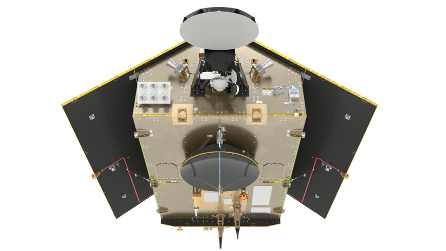
ESA, NASA, the European Commission, the European Organisation for the Exploitation of Meteorological Satellites (EUMETSAT) and the National Oceanic and Atmospheric Administration (NOAA) have renamed the upcoming Sentinel-6A satellite after Earth scientist Dr. Michael H. Freilich.
Sentinel-6 satellite renamed in honour of renowned US scientist
28.1.2020 15:20 ESA Observing the Earth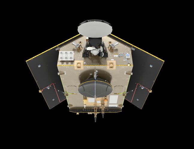
ESA, NASA, the European Commission, the European Organisation for the Exploitation of Meteorological Satellites (EUMETSAT) and the National Oceanic and Atmospheric Administration (NOAA) have renamed the upcoming Sentinel-6A satellite after Earth scientist Dr Michael H. Freilich.
‘I am a true believer in the European project’ - Carlo des Dorides talks about his time at GSA
28.1.2020 14:19 European GNSS Agency
Carlo des Dorides took up his position as executive director of the European GNSS Agency (GSA) on February 1, 2011. In the nine years since then, the Galileo programme has progressed from a project on paper to an operational programme with over a billion users around the globe. As his term at the helm of the Agency draws to an end, the GSA executive director looks back at the successes and challenges of the past nine years and speaks about his hopes for the future.
During your nine years at the head of the GSA there have been significant advances in the European GNSS programme. What do you see as the greatest achievement during your term?
When I first took up my position as executive director of the GSA, the Galileo programme only existed on paper and EGNOS had yet to be certified for use in civil aviation. Since then, we have achieved the remarkable figures of over 1 billion Galileo-enabled smartphones on the market and EGNOS present at more than 350 airports in Europe. These figures represent the culmination of the two programmes, but they also represent a remarkable path. On one hand, we built a performing system for both Galileo and EGNOS. But having a performing system is not enough - you also need to have the confidence of users. The GSA played a crucial role in building this confidence.
EGNOS is the first pan-European infrastructure for civil aviation, and in offering it to the market we were faced with many questions. There were questions about certification, about the liability chain, about the updating of avionics. The GSA worked consistently with all stakeholders and brought all of these elements together, and the result is that we now have EGNOS present at so many airports. After nine years of hard work, the figures bear testament to the fact that we have truly created a success story.
As with any venture on this scale, there have been ups and downs in building the European GNSS over the years. What have been the greatest challenges, and how were they overcome?
One difficult decision that we had to face was the decision to take over operational management of the Galileo programme in January 2017. Why was this difficult? Well, there were diverging views about operational readiness, and different assessments of the risks involved. Even though we had declared Initial Services in December 2016, the system was not complete at the time. In a sense, we were taking the wheel of a car that had not yet been fully built, which was not an easy thing to do. At the same time, the GSA itself was not fully formed – it was still a house under construction. To continue with the car analogy, we were a skilled driver, but still a young and untested driver. It was a challenge to manage this uncertainty while still building the system.
Another difficult choice was the decision to declare Initial Services, as this meant that there was now greater public scrutiny of the programme in what was essentially a period of testing and fine-tuning in preparation for the launch of Full Operating Capability. This was a blessing and a curse – while the programme’s successes were celebrated, all technical glitches were very much in the public eye. This was the case with the technical incident last year that resulted in a temporary interruption of the Galileo signal. While this incident was a setback, we learned valuable lessons and are stronger as a result.
Another challenge was when the GSA moved to Prague. At the beginning it was difficult to build the team and to attract the right profiles, as there was uncertainty about the future of the GSA and people didn’t know what to expect in Prague. A mere nine years later the Agency has grown tremendously, both in terms of staff numbers and in prestige, and Prague is one of the top-rated European capitals for quality of life. Now that GSA is expanding into the European Union Agency for the Space Programme, I don’t anticipate any problems with our capacity to attract talented professionals.

During your term, the GSA managed to bring Galileo to over 1 bln smartphones, moving the programme from paper to space and back to Earth to devices and users, what triggered this progress?
In achieving this milestone, the work of the Agency in liaising with user communities has been of fundamental importance. Our constant interaction with users through our User Consultation Platforms has given us a unique understanding of the dynamics of the GNSS market and of the needs of the various user segments. We have also compiled, in alternate years, GNSS Market Reports and GNSS User Technology Reports, which has deepened our understanding of market needs. This understanding has allowed us to effectively meet these needs – and the market has been quick to respond. The work of our Market Development Department has been important in this regard, thanks to their ongoing interaction with all the market segments.
We have also been active in communicating, both to industry and to the general public, about the benefits that Galileo offers in terms of increased accuracy, availability and robustness of the positioning, navigation and timing signal. Manufacturers have been quick to understand these benefits and have been eager to pass them on to their customers. These customers, in turn, are becoming increasingly aware of the accuracy and availability gains that Galileo offers, and this is reflected in the 1 billion smartphone milestone. This was a remarkable achievement for the Galileo programme, and the fact that it occurred in the same week that we celebrated the 15th anniversary of the Agency made it especially gratifying.
You have been leading one of the fastest growing European agencies, linking space to user needs, with assets and teams spread across Europe. What are the key elements of your leadership?
Building the right team for the job was key to my success at the head of the GSA and key to the success of the Agency in building Galileo and EGNOS. In my position as GSA executive director I had to wear many hats to understand and respond to the needs of the Agency and its growing team, along with our stakeholders and user communities. As a leader, you are responsible for guiding the team and creating the right mind-set among the team members. You need to lead by example, but you also need to play as a team member, know when to take the stage and when let others shine, and be ready to serve and do what is required of you. I am proud of the team that we have built at the GSA. I believe that GSA has a key role to play in making the EU Space programme grow and thrive both at the European and Global level.
On a more personal level, when you look back at your term as the executive director of the GSA, what gives you the most pride or satisfaction?
There are a number of things that come to mind when I look back at my term at the GSA. First of all, by helping to establish the Galileo programme, I feel that I have made a contribution to building Europe. I am a true believer in the European project. My position at the GSA gave me a wonderful opportunity to work on a concrete project that shows what the EU can achieve by working together. The European space programmes would not have been possible for any individual Member State to accomplish alone – it was only by coming together as Europeans that this became possible.
Secondly, I am proud to have helped create a future for all the staff that believed in our project and put their trust in me and in the Agency. Thanks to their dedication, the future of the Agency looks bright. I was approached by an Agency employee recently who told me that they had really enjoyed working at the GSA because of the positive working atmosphere that exists here, based on a common motivation and shared values. It takes time to build this, but it is fundamentally important. Building the GSA team was difficult in the beginning but it was an important achievement and it is one of which I am particularly proud.
What does the future look like for the European space programme and for the GSA, and do you have any ‘words of wisdom’ for your successor?
The future looks promising, both for the EU Space Programme and for the GSA. The recently approved Regulation on the EU Space Programme and on setting up the European Union Agency for the Space Programme (EUSPA) paves the way for the expansion of the programme, with an increased budget and expanded responsibilities. The approval of the Regulation shows that we have earned the confidence of the Member States. They can see that the space programme is creating economic opportunities and jobs, and understand the benefits that it offers for their citizens and for European growth.
In terms of ‘words of wisdom’ for my successor – I would just say that it is important to embrace change. We live in a dynamic world and change is an important part of our daily work. That said; change should be approached with caution. What we have built here at the GSA is the result of maturity gained over the years. I would advise that change should be preceded by careful listening to all stakeholders and careful consideration of all possible outcomes. Otherwise we could stand to lose what we have built.
Market understands value of dual frequency
28.1.2020 11:32 European GNSS Agency
Chip manufacturers are very aware of the opportunities that dual frequency offers and, correspondingly, the market has witnessed the launch of a range of mass-market dual-frequency chips targeted at various applications. In turn, smartphone manufacturers also understand the benefits that these chips provide in terms of positioning accuracy for location based services and are eager to pass on these benefits to their users.
To date, there are 41 smartphone models on the market, from 10 manufacturers, offering dual-frequency capability. One of the most recent launches by a major manufacturer was the Galaxy Note10 and Galaxy Note10+ from Samsung Electronics, which hit the market in the second half of last year. Fitted with the Broadcom BCM47755 chip, these smartphones are the first from the South Korean multinational to provide dual-frequency GNSS capability.
Users of these and other dual-frequency smartphones are able to benefit from the increased accuracy and robustness of the GNSS signal, particularly in urban environments, as dual-frequency phones are more resistant to multipath errors. Developers too are able to leverage the enhanced accuracy offered by this dual-frequency capability to create new applications requiring high accuracy, robust positioning. Check on the UseGalileo site, to see if your smartphone has dual-frequency capability.
Read this: MyGalileoApp – an ecosystem of innovation
The growing number of dual-frequency smartphones on the market clearly shows that the major electronics manufacturers understand the opportunities that this capability provides in terms of enabling a new generation of location based services. But there is one area in particular that will spark growing demand for dual frequency.
Dual-frequency – Galileo leads the way
According to the latest GNSS Market Report, published in October last year, for the 5G market in particular, the availability of accurate, cost effective and robust, dual-frequency GNSS systems will be critical in providing business opportunities. With the increased rollout of 5G internationally in the coming years, dual-frequency capability will be a key factor and we are likely to see an even greater number of compatible devices on the market.
And this: EU Space Week 2019: Investors meet innovation
This is good news for the Galileo system – dual-frequency capacity is a key Galileo differentiator, as the Galileo constellation has the highest number of dual-frequency satellites of any GNSS system. “Since the first dual-frequency GNSS smartphone hit the market back in June 2018, the trend has been towards increased implementation of dual-frequency capability in consumer platforms, allowing them to improve their location performance,” said European GNSS Agency (GSA) Head of Market Development Fiammetta Diani, adding that Galileo stands ready to support this trend.
Why is it important?
Dual-frequency capability means that the GNSS receivers are able to receive two GNSS signals at different frequencies from a satellite. In the case of Galileo, these frequencies are E1 and E5a. Dual frequency provides increased reliability to users – if one of the frequency bands fails, the other can be used as backup.
Other advantages of dual-frequency capability include a reduced signal acquisition time and improved accuracy of positioning and timing. Dual frequency also reduces problems caused by obstructions such as buildings and other obstacles, thanks to the fact that the L5/E5a signals are lower in frequency, making them are less prone to multipath interference errors.
Media note: This feature can be republished without charge provided the European GNSS Agency (GSA) is acknowledged as the source at the top or the bottom of the story. You must request permission before you use any of the photographs on the site. If you republish, we would be grateful if you could link back to the GSA website (http://www.gsa.europa.eu).
Hexagon Unveils M.App X 2020 for Enhanced Imagery Intelligence
28.1.2020 10:27 GISCafe.com Webcasts-Webinars Latest release delivers 3D display modes and accelerated visualization and analysis27 January 2020 -- (Norcross, GA. USA) -- Hexagon’s …
Oznámení o vyhlášení výběrového řízení
28.1.2020 9:15 ČÚZK - předpisy a opatření Katastrální úřad pro Královéhradecký kraj zveřejnil novou aktualitu: Oznámení o vyhlášení výběrového řízení na pracovní místo - investiční referent v oddělení hospodářské správy kanceláře ředitele Katastrálního úřadu pro Královéhradecký krajOznámení o vyhlášení výběrového řízení
28.1.2020 9:15 ČÚZK - předpisy a opatření Katastrální úřad pro Královéhradecký kraj zveřejnil novou aktualitu: Oznámení o vyhlášení výběrového řízení na pracovní místo - investiční referent v oddělení hospodářské správy kanceláře ředitele Katastrálního úřadu pro Královéhradecký krajOznámení o vyhlášení výběrového řízení
28.1.2020 9:15 ČÚZK - předpisy a opatření Katastrální úřad pro Královéhradecký kraj zveřejnil novou aktualitu: Oznámení o vyhlášení výběrového řízení na pracovní místo - investiční referent v oddělení hospodářské správy kanceláře ředitele Katastrálního úřadu pro Královéhradecký krajOznámení o vyhlášení výběrového řízení
28.1.2020 9:15 ČÚZK /Urady/Katastralni-urady/Katastralni-urady/Katastralni-urad-pro-Kralovehradecky-kraj/O-uradu/Aktuality/Oznameni-o-vyhlaseni-vyberoveho-rizeni-(2)Investiční referent v oddělení hospodářské správy kanceláře ředitele
28.1.2020 9:04 ČÚZK - volná místa Katastrální úřad pro Královéhradecký kraj - odbor hospodářské správy vypisuje výběrové řízení na místo Investiční referent v oddělení hospodářské správy kanceláře řediteleInvestiční referent v oddělení hospodářské správy kanceláře ředitele
28.1.2020 9:04 ČÚZK /Urady/Katastralni-urady/Katastralni-urady/Katastralni-urad-pro-Kralovehradecky-kraj/Volna-mista/Investicni-referent-v-oddeleni-hospodarske-spravyInvestiční referent v oddělení hospodářské správy kanceláře ředitele
28.1.2020 9:04 ČÚZK - předpisy a opatření Katastrální úřad pro Královéhradecký kraj - odbor hospodářské správyvypisuje výběrové řízení na místo
Investiční referent v oddělení hospodářské správy kanceláře ředitele
Nový C předmět Studentská odborná soutěž v GI
28.1.2020 8:46 Katedra geoinformatiky UP OlomoucOd letního semestru ak. roku 2019/20 je nově možné si zapisovat nový C předmět KGI/SOUGI Studentská odborná soutěž v GI. Popis předmětu, požadavky, motivace atd. je ve STAGu. Předmět má založen i MOODLE kurz.
The post Nový C předmět Studentská odborná soutěž v GI appeared first on Katedra geoinformatiky.
Vyjmenované zdroje znečištění ovzduší
28.1.2020 8:45 Středočeský kraj Nová mapová aplikace Vyjmenované zdroje znečištění ovzduší s povolením provozu zobrazuje stacionární zdroje znečišťování ovzduší na území Středočeského kraje, ke kterým vydal Krajský úřad Středočeského kraje povolení provozu podle zákona č. 201/2012 Sb., o ochraně ovzduší. Aplikace nabízí nepřeberné množství informací, jako např. název a kategorie zdroje znečištění dle přílohy č. 2 zákona č. 201/2012 Sb., o ochraně ovzduší, název provozovatele, kdo a kdy žádost vyřizoval, pod jakým číslem jednacím atd. U provozoven, v nichž se nachází více zdrojů znečišťování ovzduší, je vždy uveden kód hlavního zdroje provozovny. Při realizaci této aplikace byla snaha naplnit dva cíle. První cíl se zaměřuje na informovanost a osvětu veřejnosti v otázkách ochrany ovzduší, proto je i aplikace součástí Akčního plánu k implementaci Programu zlepšování kvality ovzduší Zóna Střední Čechy – CZ02. Druhým cílem je zprostředkovat zaměstnancům krajského úřadu odkazy na digitalizované dokumenty Rozhodnutí o povolení provozu k jednotlivým zdrojům. Aplikaci připravil Odbor životního prostředí a zemědělství ve spolupráci s Odborem informatiky / GIS.Kratos XQ-58A Valkyrie Flies over Yuma in Fourth Successful Flight
27.1.2020 19:18 GISCafe.com Webcasts-Webinars SAN DIEGO, Jan. 27, 2020 (GLOBE NEWSWIRE) -- Kratos Defense & Security Solutions, Inc. (NASDAQ:KTOS), a leading National Security Solutions …48-Foot Wingspan Autonomous Cargo Delivery Drone to be Unveiled at the 2020 Farnborough International Airshow
27.1.2020 19:18 GISCafe.com Webcasts-Webinars Silent Arrow® GD-2000 WB (wide-body) launched as second customer-driven aircraft in Yates Electrospace Corporation's heavy payload UAS product …AiRXOS Supercharges Ecosystem Partners to Accelerate Advanced Unmanned Operations – Empowering Customers with End-to-End Unmanned Aircraft System Solution
27.1.2020 19:18 GISCafe.com Webcasts-Webinars The AiRXOS Air MobilityTM Platform adds 11 new partners – industry-leading unmanned solutions, applications, service and business providers to …Woolpert and Optimal GEO JV Wins MAPPS Grand Award for Lidar Collection After Hurricane Maria
27.1.2020 19:18 GISCafe.com Webcasts-Webinars Woolpert and Optimal GEO were presented with the MAPPS Award for Data Acquisition & Processing and the MAPPS Grand Award for their "Hurricane Maria: …CryoSat sheds new light on Antarctica’s biggest glacier
27.1.2020 17:00 ESA Observing the Earth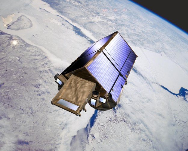
Ice loss from Pine Island Glacier has contributed more to sea-level rise over the past four decades than any other glacier in Antarctica. However, the way this huge glacier is thinning is complex, leading to uncertainty about how it is likely to raise sea level in the future. Thanks to ESA’s CryoSat mission, scientists have now been able to shed new light on these complex patterns of ice loss.
CryoSat sheds new light on ice loss from Antarctica’s biggest glacier
27.1.2020 17:00 ESA Observing the Earth
Ice loss from Pine Island Glacier has contributed more to sea-level rise over the past four decades than any other glacier in Antarctica. However, the way this huge glacier is thinning is complex, leading to uncertainty about how it is likely to raise sea level in the future. Thanks to ESA’s CryoSat mission, scientists have now been able to shed new light on these complex patterns of ice loss.
Komplexní pozemková úprava Adršpach
27.1.2020 15:13 Hrdlička Naše společnost zahájila geodetické práce v okolí Adršpašsko-teplických skal...HRDLIČKA spol. s r.o. - Komplexní pozemková úprava Adršpach
27.1.2020 15:13 Hrdlička Naše společnost zahájila geodetické práce v okolí Adršpašsko-teplických skal...Rozpočet úřadu za rok 2020
27.1.2020 11:44 ČÚZK - předpisy a opatření Český úřad zeměměřický a katastrálnívystavuje rozpočet úřadu za rok
2020
Rozpočet úřadu za rok 2020
27.1.2020 11:44 ČÚZK /Urady/Cesky-urad-zememericky-a-katastralni/Rozpocty/Rozpocet-uradu-za-rok-2020Kleos and Geollect sign Channel Partner and Integrator Agreement
27.1.2020 11:11 GISCafe.com Webcasts-Webinars • Kleos’ Scouting Mission data to improve UK based company Geollect’s dark vessel locating capability• Geollect is a leader in …Odborný referent / vrchní referent – obnova katastrálního operátu v oddělení obnovy katastrálního op
27.1.2020 7:02 ČÚZK /Urady/Katastralni-urady/Katastralni-urady/Katastralni-urad-pro-Zlinsky-kraj/Uredni-deska/Oznameni-a-jina-uredni-sdeleni/Volna-mista/DMS/Odborny-referent-vrchni-referent-–-obnova-katastOdborný referent / vrchní referent – obnova katastrálního operátu v oddělení obnovy katastrálního op
27.1.2020 7:02 ČÚZK - volná místa Katastrální úřad pro Zlínský kraj vypisuje výběrové řízení na místo Odborný referent / vrchní referent – obnova katastrálního operátu v oddělení obnovy katastrálního opOdborný referent / vrchní referent – obnova katastrálního operátu v oddělení obnovy katastrálního op
27.1.2020 7:02 ČÚZK - předpisy a opatření Katastrální úřad pro Zlínský krajvypisuje výběrové řízení na místo
Odborný referent / vrchní referent – obnova katastrálního operátu v oddělení obnovy katastrálního operátu Katastrálního úřadu pro Zlínský kraj
Státní mapa 1:5 000
27.1.2020 1:00 Cenia - Katalog metadat ČR - INSPIRE Státní mapa 1:5 000–odvozená, vydávaná postupně od roku 1950, byla zamýšlena jako provizorium. Pro první vydání byl polohopis odvozen z katastrálních map a výškopis z nejvhodnějších existujících podkladů, například z topografických map v systému S-1952, v případě nezbytnosti i z topografických sekcí 3. vojenského mapování. Polohopis zobrazoval sídla, dopravní síť, vodstvo, lesy, správní hranice a značkami místopisné podrobnosti, jako jsou mosty, kříže, sochy, komíny, věže apod., vše v šedé barvě. Výškopis byl znázorněn vrstevnicemi v závislosti na použitých výškopisných podkladech, výškovými kótami a podle potřeby technickým nebo topografickým šrafováním včetně popisu v barvě hnědé. Grafické provedení mapového rámu se v průběhu vydávání map lišilo, u prvního vydání jsou na jednoduchém přímkovém rámu vyznačeny rysky rovinné souřadnicové sítě Křovákova zobrazení v půlkilometrovém intervalu. Až do roku 1990 tyto mapy nebyly určeny veřejnosti, ale směly se používat pouze pro vnitřní potřebu státních orgánů a socialistických organizací. Do produktu jsou zařazovány kromě skenů postupných vydání Státní mapy 1:5 000–odvozené i skeny mladších map neodvozených.Test VÚV dataset
27.1.2020 1:00 Cenia - Katalog metadat ČR - INSPIRE Vrstva obsahuje vymezení chráněných území s vazbou na vodu a je formálně upravena pro potřeby reportingu podle směrnice 2000/60/ES (WFD). Obsažena jsou chráněná území, která nebyla reportována na základě jiné legislativy, tedy Ramsarské mokřady a maloplošná zvláště chráněná území. Prostorová i popisná složka dat byla upravena podle směrných dokumentů a požadavků Evropské komise na reporting Plánů oblastí povodí v roce 2016.Test VÚV WFS
27.1.2020 1:00 Cenia - Katalog metadat ČR - INSPIRE vrstva obsahuje vymezení chráněných území s vazbou na vodu a je formálně upravena pro potřeby reportingu podle směrnice 2000/60/ES (WFD). Obsažena jsou chráněná území, která nebyla reportována na základě jiné legislativy, tedy Ramsarské mokřady a maloplošná zvláště chráněná území. Prostorová i popisná složka dat byla upravena podle směrných dokumentů a požadavků Evropské komise na reporting Plánů oblastí povodí v roce 2016.Lego model ISS (Mezinárodní vesmírné stanice)
26.1.2020 1:30 GeoBusinessFirma Lego vydává v edici Lego Ideas novou sadu, která obsahuje kompletní Mezinárodní vesmírnou stanici včetně takových detailů jako je Space Shuttle. Mezinárodní vesmírná stanice, známější pod zkratkou ISS, je osídlena od listopadu 2000, kdy na stanici vstoupila první stálá posádka. Lego model ISS, který má 864 dílků a cena je 70 dolarů, bude na […]
The post Lego model ISS (Mezinárodní vesmírné stanice) appeared first on GeoBusiness.
Lego model Mezinárodní vesmírné stanice
26.1.2020 1:30 GeoBusinessFirma Lego vydává v edici Lego Ideas novou sadu, která obsahuje kompletní Mezinárodní vesmírnou stanici včetně takových detailů jako je Space Shuttle. Mezinárodní vesmírná stanice, známější pod zkratkou ISS, je osídlena od listopadu 2000, kdy na stanici vstoupila první stálá posádka. Lego model ISS, který má 864 dílků a cena je 70 dolarů, bude na […]
The post Lego model Mezinárodní vesmírné stanice appeared first on GeoBusiness.
Lego model Mezinárodní vesmírné stanice
26.1.2020 1:30 GeoBusiness Firma Lego vydává v edici Lego Ideas novou sadu, která obsahuje kompletní Mezinárodní vesmírnou stanici včetně takových detailů jako je Space Shuttle. Mezinárodní vesmírná stanice, známější pod zkratkou ISS, je osídlena od listopadu 2000, kdy na stanici vstoupila první stálá posádka. Lego model ISS, který má 864 dílků a cena je 70 dolarů, bude na […]VZ: Nadlimitní komplexní pozemkové úpravy v Hřensku
26.1.2020 0:55 ZeměměřičStátní pozemkový úřad vypsal nadlimitní veřejnou zakázku na komplexní pozemkové úpravy v katastrálních územích Janov u Hřenska a Oldřichov nad Ploučnicí. Zadavatel v souladu s ustanovením § 101 zákona, dělí veřejnou zakázku na dvě (2) části, které svým předmětem vymezuje takto: Část 1 – KoPÚ v k.ú. Janov u Hřenska Předmětem plnění veřejné zakázky je zpracování návrhu komplexní pozemkové úpravy (dále jen […]
The post VZ: Nadlimitní komplexní pozemkové úpravy v Hřensku appeared first on Zeměměřič.
Esri Partners with OSI to Provide Advanced GIS Capabilities and Real-Time Monitoring to Utilities
24.1.2020 18:07 GISCafe.com Webcasts-Webinars Customers Will Have Joint Access to the monarch™ Platform and the ArcGIS Utility Network Management ExtensionREDLANDS, Calif. — (BUSINESS …
A Day in the Life of Flirtey: The Future of Delivery (VIDEO)
24.1.2020 18:07 GISCafe.com Webcasts-Webinars RENO, Nev., Jan. 24, 2020 — (PRNewswire) — Flirtey, the industry-leading drone delivery service, released today a rare, inside …Contract secures build of ozone-monitoring Altius satellite
24.1.2020 16:20 ESA Observing the Earth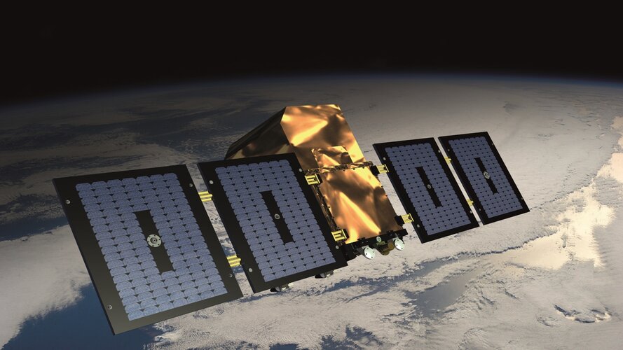
ESA has awarded a contract to QinetiQ to build Altius. This new mission will deliver profiles of concentrations of stratospheric ozone with high vertical resolution, as well as profiles of other atmospheric trace gases.
Aktualizace dat v mapových aplikacích
24.1.2020 14:05 Jihočeský kraj Data katastru nemovitostí (DKM, KMD, KM-D a ÚKM) byla v mapových aplikacích i výdejním modulu aktualizována k 1. 1. 2020.Informace o výsledcích kontrol dle § 26 zákona č. 255/2012 Sb. za rok 2019
24.1.2020 13:35 ČÚZK - předpisy a opatření Zeměměřický a katastrální inspektorát v Českých Budějovicíchvydává informace o výsledcích kontrol dle § 26 zákona č. 255/2012 Sb. za rok
2019
Jakub Karas se stal tento týden novým prezidentem Aliance pro bezpilotní letecký průmysl
24.1.2020 11:53 UpVisionJakub Karas se stal tento týden novým prezidentem Aliance pro bezpilotní letecký průmysl. Novým prezidentem Aliance pro bezpilotní letecký průmysl se stal Ing. Jakub Karas (UpVision) a novými členy představenstva Ing. Robert Šinkner (TKP geo) a Ing. Vladímír Hůda (EasyMap), kteří byli zvoleni na valné hromadě UAVA tento týden v Plzni. Chystáme v tomto důležitém roce z hlediska […]
The post Jakub Karas se stal tento týden novým prezidentem Aliance pro bezpilotní letecký průmysl appeared first on Upvision.
AGILE PHD SCHOOL aneb jak jsme domluvili Erasmus v Estonsku
24.1.2020 11:18 Katedra geoinformatiky UP OlomoucCo jsou letní školy jistě všichni znáte. I my doktorandi ve složení Kuba Koníček, Markéta Beitlová a Radek Barvíř jsme se na jednu takovou nedávno vypravili. A když už na letní školu, tak poslední listopadový víkend a do mrazivého Estonska ❄️😁 Čekal nás týden v univerzitním městě Tartu zaměřený na časoprostorovou geovizualizaci a rozvoj našich […]
The post AGILE PHD SCHOOL aneb jak jsme domluvili Erasmus v Estonsku appeared first on Katedra geoinformatiky.
AGILE PHD SCHOOLaneb jak jsme domluvili Erasmus v Estonsku
24.1.2020 11:18 Katedra geoinformatiky UP OlomoucCo jsou letní školy jistě všichni znáte. I my doktorandi ve složení Kuba Koníček, Markéta Beitlová a Radek Barvíř jsme se na jednu takovou nedávno vypravili. A když už na letní školu, tak poslední listopadový víkend a do mrazivého Estonska ❄️😁 Čekal nás týden v univerzitním městě Tartu zaměřený na časoprostorovou geovizualizaci a rozvoj našich […]
The post AGILE PHD SCHOOLaneb jak jsme domluvili Erasmus v Estonsku appeared first on Katedra geoinformatiky.
Informace o výsledcích kontrol dle § 26 zákona č. 255/2012 Sb. za rok 2019
24.1.2020 10:43 ČÚZK - předpisy a opatření Český úřad zeměměřický a katastrálníInformace o výsledcích kontrol dle § 26 zákona č. 255/2012 Sb. za rok 2019
2019
GISCafe Industry Predictions 2020 – Part 4 by Susan Smith
24.1.2020 10:15 GISCafe.com Webcasts-WebinarsURISA Announces the Release of the 2nd Edition of The GIS Management Handbook
24.1.2020 10:10 GISCafe.com Webcasts-Webinars Des Plaines, IL (January 23, 2020) -- URISA is pleased to announce the release of the second edition of The GIS Management Handbook. This is a …Earth from Space: Deforestation in Bolivia
24.1.2020 10:00 ESA Observing the Earth Video:
00:03:15
Video:
00:03:15
This week's edition of the Earth from Space programme features a Copernicus Sentinel-2 image over an area in the Santa Cruz Department of Bolivia, where part of the tropical dry forest has been cleared for agricultural use.
See also Deforestation in Bolivia to download the image.
Earth from Space: Deforestation in Bolivia
24.1.2020 10:00 ESA Observing the Earth
Video:
00:03:15
This week's edition of the Earth from Space programme features a Copernicus Sentinel-2 image over an area in the Santa Cruz Department of Bolivia, where part of the tropical dry forest has been cleared for agricultural use.
See also Deforestation in Bolivia to download the image.
This week's edition of the Earth from Space programme features a Copernicus Sentinel-2 image over an area in the Santa Cruz Department of Bolivia, where part of the tropical dry forest has been cleared for agricultural use.
See also Deforestation in Bolivia to download the image.
Earth from Space: Deforestation in Bolivia
24.1.2020 10:00 ESA Observing the Earth
Video:
00:03:15
This week's edition of the Earth from Space programme features a Copernicus Sentinel-2 mage over an area in the Santa Cruz Department of Bolivia, where part of the tropical dry forest has been cleared for agricultural use.
See also Deforestation in Bolivia to download the image.
Deforestation in Bolivia
24.1.2020 10:00 ESA Observing the Earth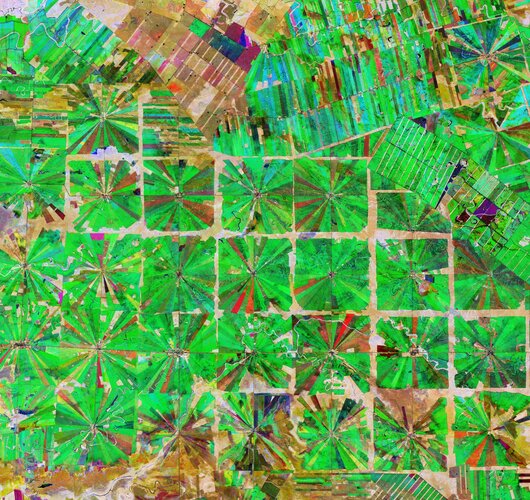 Image:
This Copernicus Sentinel-2 image features an area in the Santa Cruz Department of Bolivia, where part of the tropical dry forest has been cleared for agricultural use.
Since the 1980s, the area has been rapidly deforested owing to a large agricultural development effort where people from the Andean high plains (the Altiplano region) have been relocated to the lowlands of Bolivia.
The relatively flat lowlands and abundant rainfall make this region suitable for farming. In fact, the local climate allows farmers to benefit from two growing seasons. The region has been transformed from dense forest into a patterned expanse of agricultural land. This deforestation method, common in this part of Bolivia, is characterised by the radial patterns that can be seen clearly in the image.
Each patterned field is approximately 20 sq km and each side is around 2.5 km long.
Small settlements can be seen in the centre of each individual field in the image, which typically contain a church, a school and a soccer field. These communities are joined by a road network depicted by the straight lines that bisect the radial fields and connect the adjacent areas.
Meandering streams and rivers can be seen flowing through the fields. The long, thin strips of land in the top right of the image are most likely cultivated soybean fields.
Rainforests worldwide are being destroyed at an alarming rate. This is of great concern as they play an important role in global climate, and are home to a wide variety of plants and animals.
Because of their unique perspective from space, Earth observation satellites are instrumental in providing comprehensive information on the full extent and rate of deforestation, which is particularly useful for monitoring remote areas.
This composite image was created by combing three separate ‘Normalised Difference Vegetation Index’ images from the Copernicus Sentinel-2 mission. The first image, from 8 April 2019, is visible in red; the second from 22 June 2019, can be seen in green; and the third from 5 September 2019 can be seen in blue. The Normalised Difference Vegetation Index is widely used in remote sensing as it gives scientists an accurate measure of healthy and status of plant growth.
This image is also featured on the Earth from Space video programme.
Zveřejnění obsahu informací poskytnutých na žádost dle zákona č. 106/1999 Sb. za rok 2020
24.1.2020 9:00 ČÚZK - předpisy a opatření Katastrální úřad pro Jihomoravský krajzveřejňuje obsah informace poskytnutých na žádost dle zákona č. 106/1999 Sb. za rok
2020
Zveřejnění obsahu informací poskytnutých na žádost dle zákona č. 106/1999 Sb. za rok 2020
24.1.2020 9:00 ČÚZK /Urady/Katastralni-urady/Katastralni-urady/Katastralni-urad-pro-Jihomoravsky-kraj/Casto-hledane-informace/Poskytovani-informaci-106-1999-Sb/Zverejneni-obsahu-informaci-poskytnutych-na-za-(1)/Zverejneni-obsahu-informaci-poskytnutych-na-za-(2)Aktualizace datového skladu ÚAP
24.1.2020 7:20 Ústecký krajUpozorňujeme uživatele Geoportálu územně analytických podkladů, že v týdnu od 27.1.2020 do 7.2.2020 bude probíhat úprava funkčních komponent geoportálu v souvislosti s přechodem na novou verzi datového modelu. V tomto termínu nebude funkční výdej dat.
Aktualizace datového skladu ÚAP
24.1.2020 7:20 Ústecký krajUpozorňujeme uživatele Geoportálu územně analytických podkladů, že v týdnu od 27.1.2020 do 31.1.2020 bude probíhat úprava funkčních komponent geoportálu v souvislosti s přechodem na novou verzi datového modelu. V tomto termínu nebude funkční výdej dat.
James Norrod Named CEO Of PrecisionHawk
24.1.2020 2:00 GISCafe.com Webcasts-Webinars Seasoned Technology Executive with Extensive Experience in Strategic Partnerships to Lead Top Commercial Drone Company Through Next Phase of …Hexagon Announces Changes to Management Team
24.1.2020 2:00 GISCafe.com Webcasts-Webinars NACKA STRAND, Sweden, Jan. 23, 2020 — (PRNewswire) — Hexagon AB, a global leader in sensor, software and autonomous solutions, today …Alaska Signs Participating Addendum with DroneUp Providing Public Sector Agencies Access to Drone Services
23.1.2020 14:49 GISCafe.com Webcasts-Webinars VIRGINIA BEACH, Va., Jan. 14, 2020 — (PRNewswire) — DroneUp, LLC and the State of Alaska have signed a Participating Addendum for the …New Light Technologies Announces the Automated Infrastructure Compliance Framework (AICF)
23.1.2020 14:49 GISCafe.com Webcasts-Webinars WASHINGTON, Jan. 14, 2020 — (PRNewswire) — New Light Technologies Inc. (NLT) is proud to release the Automated Infrastructure …Galileo now replying to SOS messages worldwide
23.1.2020 14:22 ESA NavigationAs well as providing global navigation services, Europe’s Galileo satellite constellation is contributing to saving more than 2000 lives annually by relaying SOS messages to first responders. And from now on the satellites will reply to these messages, assuring people in danger that help is on the way.
Galileo now replying to SOS messages worldwide
23.1.2020 14:22 ESA Navigation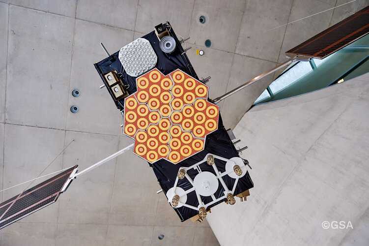
As well as providing global navigation services, Europe’s Galileo satellite constellation is contributing to saving more than 2000 lives annually by relaying SOS messages to first responders. And from now on the satellites will reply to these messages, assuring people in danger that help is on the way.
Galileo now replying to SOS messages worldwide
23.1.2020 14:22 ESA Navigation
As well as providing global navigation services, Europe’s Galileo satellite constellation is acontributing to saving more than 2000 lives annually by relaying SOS messages to first responders. And from now on the satellites will reply to these messages, assuring people in danger that help is on the way.
Taal volcano blanketed by ash
23.1.2020 13:45 ESA Observing the EarthThe Philippines’ Taal volcano erupted on 12 January 2020 – spewing an ash plume approximately 15 km high and forcing large-scale evacuations in the nearby area.
This almost cloud-free image was captured today 23 January at 02:20 UTC (10:20 local time) by the Copernicus Sentinel-2 mission, and shows the island, in the centre of the image, completely covered in a thick layer of ash.
This optical image has also been processed using the mission’s short-wave infrared band to show the ongoing activity in the crater, visible in bright red. Ash blown by strong winds can be seen in Agoncillo, visible southwest of the Taal volcano. Ash has also recorded in other areas of the Batangas province, as well as Manila and Quezon.
According to The Philippine Institute of Volcanology and Seismology bulletin published today, sulphur dioxide emissions were measured at an average of around 140 tonnes. The Taal volcano still remains on alert level four, meaning an explosive eruption is possible in the coming hours or days. The highest alert level is five which indicates an eruption is taking place.
According to the National Disaster Risk Reduction and Management Council, over 50 000 people have been affected so far. In response to the eruption, the Copernicus Emergency Mapping Service was activated. The service uses satellite observations to help civil protection authorities and, in cases of disaster, the international humanitarian community, respond to emergencies.
Taal volcano blanketed by ash
23.1.2020 13:45 ESA Observing the EarthThe Philippines’ Taal volcano erupted on 12 January 2020 – spewing an ash plume approximately 15 km high and forcing large-scale evacuations in the nearby area.
This almost cloud-free image was captured today 23 January at 02:20 GMT (10:20 local time) by the Copernicus Sentinel-2 mission, and shows the island, in the centre of the image, completely covered in a thick layer of ash.
This optical image has also been processed using the mission’s short-wave infrared band to show the ongoing activity in the crater, visible in bright red. Ash blown by strong winds can be seen in Agoncillo, visible southwest of the Taal volcano. Ash has also been recorded in other areas of the Batangas province, as well as Manila and Quezon.
According to The Philippine Institute of Volcanology and Seismology bulletin published today, sulphur dioxide emissions were measured at an average of around 140 tonnes. The Taal volcano still remains on alert level four, meaning an explosive eruption is possible in the coming hours or days. The highest alert level is five which indicates an eruption is taking place.
According to the National Disaster Risk Reduction and Management Council, over 50 000 people have been affected so far. In response to the eruption, the Copernicus Emergency Mapping Service was activated. The service uses satellite observations to help civil protection authorities and, in cases of disaster, the international humanitarian community, respond to emergencies.
Publikována nová sestavení pro
23.1.2020 13:31 GEUSware Publikována nová sestavení programů:GEUS 24.0.2.255 - podrobný seznam změn zde. Stáhnout nové sestavení
GEOMETR 18.0.11 - podrobný seznam změn zde. Stáhnout nové sestavení
Zakladatel firmy končí po 30 letech svou aktivní práci
23.1.2020 13:29 Hrdlička Kdo jiný, než já by se měl zhostit této role a poděkovat tátovi za všechno, co jsme spolu v profesním životě prožili.HRDLIČKA spol. s r.o. - Zakladatel firmy končí po 30 letech svou aktivní práci
23.1.2020 13:29 Hrdlička Kdo jiný, než já by se měl zhostit této role a poděkovat tátovi za všechno, co jsme spolu v profesním životě prožili.3D a BIM – základ moderní výstavby
23.1.2020 13:28 Hrdlička Věnujeme se zpracováním dokumentace stávajících stavebních objektů na základě..HRDLIČKA spol. s r.o. - 3D a BIM – základ moderní výstavby
23.1.2020 13:28 Hrdlička Věnujeme se zpracováním dokumentace stávajících stavebních objektů na základě..5. porada vedení firem holdingu HRDLIČKA Group
23.1.2020 13:27 Hrdlička V říjnu se konala 5. porada vedení firem holdingu HRDLIČKA Group, kterou hostila..HRDLIČKA spol. s r.o. - 5. porada vedení firem holdingu HRDLIČKA Group
23.1.2020 13:27 Hrdlička V říjnu se konala 5. porada vedení firem holdingu HRDLIČKA Group, kterou hostila..CoreLogic Acquires Location, Inc.
23.1.2020 12:26 GISCafe.com Webcasts-Webinars Acquisition expands insurance risk analytics and real estate insights for CoreLogic customers for non-weather water and fire, hail and crime risk …Geospatial World Forum 2020 to highlight the value of geospatial technology in digital economy in the 5G Era
23.1.2020 12:14 GISCafe.com Webcasts-Webinars Focus on 5G, AI, Autonomous Vehicles, Big Data, Cloud, IoT and LiDAR in various user industries, including digital cities, construction & …20200123 Odborný referent oddělení právních vztahů k nemovitostem
23.1.2020 11:09 ČÚZK - předpisy a opatření Katastrální úřad pro Středočeský kraj - Katastrální pracoviště Mělník Vyhlášení výběrového řízení: Odborný referent oddělení právních vztahů k nemovitostem V části "Úřední deska", v sekci "Oznámení a jiná úřední sdělení" bylo vystaveno "Oznámení o vyhlášení výběrového řízení na obsazení služebního místa Odborný referent oddělení právních vztahů k nemovitostem"20200113 Rada / odborný rada oddělení právních vztahů k nemovitostem
23.1.2020 11:09 ČÚZK /Urady/Katastralni-urady/Katastralni-urady/Katastralni-urad-pro-Stredocesky-kraj/Katastralni-pracoviste/KP-Melnik/O-uradu/Aktuality/20190828-Odborny-rada-oddeleni-pravnich-vztahu-(1)20200123 Odborný referent oddělení právních vztahů k nemovitostem
23.1.2020 11:09 ČÚZK /Urady/Katastralni-urady/Katastralni-urady/Katastralni-urad-pro-Stredocesky-kraj/Katastralni-pracoviste/KP-Melnik/O-uradu/Aktuality/20190828-Odborny-rada-oddeleni-pravnich-vztahu-(1)ICC 2021 posunuta na prosinec
23.1.2020 7:00 Česká asociace pro geoinformace 29. Mezinárodní Kartografická Konference 2021 (ICC 2021) ve Florencii byla posunuta z původního červencového termínu na 13. - 17. prosince 2021 !CoreLogic Raises Fourth Quarter and Full-Year 2019 Financial Guidance
23.1.2020 0:40 GISCafe.com Webcasts-Webinars Strong Operating Performance Highlighted by Revenue Growth and Favorable Mix, Significant Margin Expansion and Capital ReturnIRVINE, Calif. — …
Sedaru, Inc. is selected for Nevada Irrigation District Enterprise Asset Management
23.1.2020 0:40 GISCafe.com Webcasts-Webinars Northern California water utility serving 27,000 homes and businesses signs multi-year contract.SAN DIMAS, Calif., Jan. 22, 2020 — …
EcoPoint Flowline Mapping Service Offers Operator Compliance, Geospatial Database
22.1.2020 19:47 GISCafe.com Webcasts-Webinars DENVER, Jan. 16, 2020 — (PRNewswire) — Operators of underground oil and gas flowlines in Colorado can comply with newly revised state …Foxfury Reveals the D3060 -- A Small Format Drone & Utility Light
22.1.2020 19:17 GISCafe.com Webcasts-Webinars D3060 light meets global regulations for UAV night flight and anti-collision lightingOCEANSIDE, Calif., Jan. 16, 2020 — (PRNewswire) — …
Descartes Labs Launches First Cloud-Based Geospatial Data Refinery and Modeling Platform
22.1.2020 18:04 GISCafe.com Webcasts-Webinars SANTA FE, N.M., Jan. 22, 2020 (GLOBE NEWSWIRE) -- Descartes Labs, a New Mexico-based geospatial analytics company, today announced the availability …Inpixon's Indoor Mapping Platform Selected for Patient Wayfinding
22.1.2020 18:04 GISCafe.com Webcasts-Webinars PALO ALTO, Calif. and TORONTO, Jan. 22, 2020 — (PRNewswire) — Inpixon (Nasdaq: INPX), a leading indoor data company that …Flowfinity Launches Geographic Information System (GIS) Mapping Capabilities to Aid Field Data Collection
22.1.2020 18:04 GISCafe.com Webcasts-Webinars VANCOUVER, British Columbia, Jan. 22, 2020 — (PRNewswire) — Flowfinity Wireless Inc. today released a software update that allows …Draganfly Releases New Payloads to Increase Efficiency and Data Collection Quality
22.1.2020 18:04 GISCafe.com Webcasts-Webinars Vancouver, British Columbia , Jan. 22, 2020 (GLOBE NEWSWIRE) -- Draganfly Inc. (CSE: DFLY) (OTCQB: DFLYF) (FSE: 3U8) (“Draganfly” or the …UTGIS Technology Protects Dogs and Humans from Winter Sidewalk Electrical Hazards
22.1.2020 18:04 GISCafe.com Webcasts-Webinars PORT ST. LUCIE, Fla., Jan. 22, 2020 — (PRNewswire) — Four separate dog injuries in Chicago over the past ten days reminds us that …Watch live: Copernicus4regions debate
22.1.2020 16:35 ESA Observing the Earth
Copernicus4regions: live debate from the European Parliament
On 23 January at 08:30 CET hear how Copernicus is used for public policies
Den otevřených dveří 2020 [Knihovna geografie, byTopic]
22.1.2020 16:10 Katedra aplikované geoinformatiky a kartografie Přf UK V pátek a sobotu 24. a 25. ledna 2020 proběhne na naší fakultě Den otevřených dveří. Srdečně jsou zváni nejen všichni zájemci o studium přírodních a společenských věd z řad středoškoláků posledních, ale i nižších ročníků, nebo absolventů bakalářského studia.Want to know more about EGNSS for geomatics?
22.1.2020 15:07 European GNSS Agency
Many promising geomatics applications benefit from the European navigation programmes Galileo and EGNOS. Land, marine and mine surveying, infrastructure monitoring and mapping and GIS applications that require high precision GNSS are all enabled by both the EU satellite navigation systems. The European GNSS Agency (GSA), together with Geospatial Media, invites you to participate in a free webinar - EGNSS for Geomatics – where you can learn about everything that EGNSS has to offer for geomatics.
GNSS is one of the key Geomatics technologies along with GIS, Earth Observation and Remote Sensing, to help with the geospatial data acquisition. Geomatics disciplines include the geo-data collection means and techniques used in land surveying (including cadastral, construction, mapping and GIS, mining or infrastructure monitoring), photogrammetry, remote sensing, marine surveying and other emerging tools such as drones or mobile mapping, for which high-precision GNSS is either paramount, or a key enabler. EGNOS and Galileo are the two EU satellite navigation systems that provide high-quality positioning, navigation and timing services to users across the whole world.
In the webinar EGNSS for Geomatics experts in navigation and geomatics will guide you through the Galileo and EGNOS programmes, the use, the benefits, the added value for the geomatics user community, and the applications already available as well as the innovation potential.
Save the date in your calendar: Thursday, 23 January at 14:00 CET.
Don´t miss out - REGISTER NOW!
Media note: This feature can be republished without charge provided the European GNSS Agency (GSA) is acknowledged as the source at the top or the bottom of the story. You must request permission before you use any of the photographs on the site. If you republish, we would be grateful if you could link back to the GSA website (http://www.gsa.europa.eu).
Want to know more about EGNSS for geomatics?
22.1.2020 15:07 European GNSS AgencyMany promising geomatics applications benefit from the European navigation programmes Galileo and EGNOS. Land, marine and mine surveying, infrastructure monitoring and mapping and GIS applications that require high precision GNSS are all enabled by both the EU satellite navigation systems. The European GNSS Agency (GSA), together with Geospatial Media, invites you to participate in a free webinar - EGNSS for Geomatics – where you can learn about everything that EGNSS has to offer for geomatics.
GNSS is one of the key Geomatics technologies along with GIS, Earth Observation and Remote Sensing, to help with the geospatial data acquisition. Geomatics disciplines include the geo-data collection means and techniques used in land surveying (including cadastral, construction, mapping and GIS, mining or infrastructure monitoring), photogrammetry, remote sensing, marine surveying and other emerging tools such as drones or mobile mapping, for which high-precision GNSS is either paramount, or a key enabler. EGNOS and Galileo are the two EU satellite navigation systems that provide high-quality positioning, navigation and timing services to users across the whole world.
In the webinar EGNSS for Geomatics experts in navigation and geomatics will guide you through the Galileo and EGNOS programmes, the use, the benefits, the added value for the geomatics user community, and the applications already available as well as the innovation potential.
Save the date in your calendar: Thursday, 23 January at 14:00 CET.
Don´t miss out - REGISTER NOW!
Media note: This feature can be republished without charge provided the European GNSS Agency (GSA) is acknowledged as the source at the top or the bottom of the story. You must request permission before you use any of the photographs on the site. If you republish, we would be grateful if you could link back to the GSA website (http://www.gsa.europa.eu).
Informace o výsledcích kontrol dle § 26 zákona č. 255/2012 Sb. za rok 2019
22.1.2020 14:28 ČÚZK - předpisy a opatření Zeměměřický a katastrální inspektorát v Opavěvydává informace o výsledcích kontrol dle § 26 zákona č. 255/2012 Sb. za rok
2019
20200122 - Výběrové řízení KP Břeclav
22.1.2020 14:24 ČÚZK - předpisy a opatření Český úřad zeměměřický a katastrální zveřejnil novou aktualitu: Oznámení o vyhlášení výběrového řízení na obsazení služebního místa ředitele katastrálního pracoviště Břeclav.20200122 - Výběrové řízení KP Břeclav
22.1.2020 14:24 ČÚZK /Aktuality-resort/2020/20200122-Vyberove-rizeni-KP-BreclavRozpočet úřadu za rok 2020
22.1.2020 12:18 ČÚZK /Urady/Katastralni-urady/Katastralni-urady/Katastralni-urad-pro-Jihomoravsky-kraj/Rozpocet/Rozpocet-uradu-za-rok-2020Rozpočet úřadu za rok 2020
22.1.2020 12:18 ČÚZK - předpisy a opatření Katastrální úřad pro Jihomoravský krajvystavuje rozpočet úřadu za rok
2020
Rada / odborný rada - ředitel Katastrálního pracoviště Břeclav
22.1.2020 12:17 ČÚZK - volná místa Katastrální úřad pro Jihomoravský kraj vypisuje výběrové řízení na místo Rada / odborný rada - ředitel Katastrálního pracoviště BřeclavRada / odborný rada - ředitel Katastrálního pracoviště Břeclav
22.1.2020 12:17 ČÚZK /Urady/Katastralni-urady/Katastralni-urady/Katastralni-urad-pro-Jihomoravsky-kraj/Uredni-deska/Oznameni-a-jina-uredni-sdeleni/Volna-mista/DMS/Rada-odborny-rada-reditel-Katastralniho-pracovRada / odborný rada - ředitel Katastrálního pracoviště Břeclav
22.1.2020 12:17 ČÚZK - předpisy a opatření Katastrální úřad pro Jihomoravský krajvypisuje výběrové řízení na místo
Rada / odborný rada - ředitel Katastrálního pracoviště Břeclav
Rada / odborný rada - ředitel Katastrálního pracoviště Břeclav
22.1.2020 12:17 ČÚZK - volná místa Katastrální úřad pro Jihomoravský kraj Katastrální pracoviště Břeclav vypisuje výběrové řízení na místo Rada / odborný rada - ředitel Katastrálního pracoviště BřeclavRada / odborný rada - ředitel Katastrálního pracoviště Břeclav
22.1.2020 12:17 ČÚZK - předpisy a opatření Katastrální úřad pro Jihomoravský kraj Katastrální pracoviště Břeclavvypisuje výběrové řízení na místo
Rada / odborný rada - ředitel Katastrálního pracoviště Břeclav
odborný referent/vrchní referent – vedení katastrální mapy, potvrzování geometrických plánů
22.1.2020 11:58 ČÚZK /Urady/Katastralni-urady/Katastralni-urady/Katastralni-urad-pro-hlavni-mesto-Prahu/Uredni-deska/Oznameni-a-jina-uredni-sdeleni/Volna-mista/DMS/odborny-referent-vrchni-referent-–-vedeni-katastraodborný referent/vrchní referent – vedení katastrální mapy, potvrzování geometrických plánů
22.1.2020 11:58 ČÚZK - předpisy a opatření Katastrální úřad pro hlavní město Prahu Katastrální pracoviště Prahavypisuje výběrové řízení na místo
odborný referent/vrchní referent – vedení katastrální mapy, potvrzování geometrických plánů
odborný referent/vrchní referent – vedení katastrální mapy, potvrzování geometrických plánů
22.1.2020 11:58 ČÚZK - volná místa Katastrální úřad pro hlavní město Prahu Katastrální pracoviště Praha vypisuje výběrové řízení na místo odborný referent/vrchní referent – vedení katastrální mapy, potvrzování geometrických plánůOGC seeks public comment on Core Tiling Conceptual and Logical Models Abstract Specification Topic
22.1.2020 10:10 GISCafe.com Webcasts-Webinars Candidate Abstract Specification Topic defines a conceptual model for tiling space of any number of dimensions, as well as a logical model for tiling …Epazz, Inc. Holdings: ZenaPay Inc. Receives Preorders of ZenaDrone with the Now Corporation for its ZenaDrone Smart Farming Solution
22.1.2020 9:37 GISCafe.com Webcasts-Webinars CHICAGO, Jan. 21, 2020 (GLOBE NEWSWIRE) -- via NEWMEDIAWIRE -- Epazz Inc. (OTC: EPAZ), a leading provider of drone technology, blockchain …Construction Starts Fall 21% in December
22.1.2020 9:37 GISCafe.com Webcasts-Webinars Construction starts end 2019 essentially even with the previous yearHAMILTON, N.J. — (BUSINESS WIRE) — January 21, 2020 …
Vexcel Imaging to Acquire Image Survey Expertise and Data Assets from Verisk to Support New Strategic Partnership
22.1.2020 9:37 GISCafe.com Webcasts-Webinars JERSEY CITY, N.J., and BOULDER, Colo., Jan. 21, 2020 (GLOBE NEWSWIRE) -- Vexcel Imaging, a leader in aerial imagery data, large-format aerial …Atlantic enhances its airborne capability with Teledyne Optech’s new Galaxy T2000 and G2 sensor system
22.1.2020 9:35 GISCafe.com Webcasts-Webinars Vaughan, Ontario, January 21, 2020 — Teledyne Optech, a Teledyne Technologies [NYSE:TDY] company and global leader in lidar sensing, is pleased …Výběrové řízení na stipendijní pobyty v Polsku
22.1.2020 0:00 Geografický ústav MUBylo vypsáno výběrového řízení na stipendijní pobyty pro studenty a akademické pracovníky v Polsku.
Termín odevzdání přihlášek je 22. ledna 2020.
Detailní informace - https://www.dzs.cz/file/8183/POLSKO%20VR_AIA_20-21.pdf