


zprávy
zdroje zpráv:ČGS – Cestovatelský úterek 1. 12. 2015 (Nepál)
24.11.2015 18:28 Katedra geografie UP Olomouc Zveme Vás na přednášku v cyklu Cestovatelské úterkyNepál: Prezentace z vibrující země
která se uskuteční v úterý 1. prosince 2015 od 18.30 do 20.00 na učebně LP 3005. Přednáší Lukáš Sobek a Aleš Říhošek (pozvánka).
Introducing Scenario Services CONNECT Edition, a Cloud Service for High Performance Optioneering
24.11.2015 15:58 Bentley SystemsSpace for Earth
24.11.2015 15:54 ESA Observing the Earth
Euronews: As the COP21 Paris Climate Summit approaches, scientists explain how space technology is used to get a global perspective of our planet regarding climate change
Výpadek WAN
24.11.2015 14:31 ČÚZK - předpisy a opatření /Urady/Katastralni-urady/Katastralni-urady/Katastralni-urad-pro-Jihomoravsky-kraj/Katastralni-pracoviste/KP-Hustopece/O-uradu/Aktuality/Vypadek-WANVýpadek WAN
24.11.2015 14:31 ČÚZK /Urady/Katastralni-urady/Katastralni-urady/Katastralni-urad-pro-Jihomoravsky-kraj/Katastralni-pracoviste/KP-Hustopece/O-uradu/Aktuality/Vypadek-WANESA vyzývá k podání návrhů na novou misi třídy Earth Explorer
24.11.2015 14:25 Český Kosmický PortálESA vyzvala vědce, kteří jsou zapojeni do programů dálkového průzkumu Země, aby zaslali své návrhy na realizaci další mise z programu Earth Explorer.
ESA vyzývá k podání návrhů na novou misi třídy Earth Explorer
24.11.2015 14:25 Český Kosmický PortálESA vyzvala vědce, kteří jsou zapojeni do programů dálkového průzkumu Země, aby zaslali své návrhy na realizaci další mise z programu Earth Explorer.
Odborný referent – zápis v řízení V a Z v oddělení právních vztahů k nemovitostem
24.11.2015 13:37 ČÚZK /Urady/Katastralni-urady/Katastralni-urady/Katastralni-urad-pro-Zlinsky-kraj/Volna-mista/odborny-referent-–-zapis-v-rizeni-V-a-Z-v-oddeleniOdborný referent – zápis v řízení V a Z v oddělení právních vztahů k nemovitostem
24.11.2015 13:37 ČÚZK - volná místa /Urady/Katastralni-urady/Katastralni-urady/Katastralni-urad-pro-Zlinsky-kraj/Uredni-deska/Oznameni-a-jina-uredni-sdeleni/Volna-mista/odborny-referent-–-zapis-v-rizeni-V-a-Z-v-oddeleniOdborný referent – zápis v řízení V a Z v oddělení právních vztahů k nemovitostem
24.11.2015 13:37 ČÚZK /Urady/Katastralni-urady/Katastralni-urady/Katastralni-urad-pro-Zlinsky-kraj/Uredni-deska/Oznameni-a-jina-uredni-sdeleni/Volna-mista/odborny-referent-–-zapis-v-rizeni-V-a-Z-v-oddeleniOdborný referent – zápis v řízení V a Z v oddělení právních vztahů k nemovitostem
24.11.2015 13:37 ČÚZK - předpisy a opatření /Urady/Katastralni-urady/Katastralni-urady/Katastralni-urad-pro-Zlinsky-kraj/Uredni-deska/Oznameni-a-jina-uredni-sdeleni/Volna-mista/odborny-referent-–-zapis-v-rizeni-V-a-Z-v-oddeleniOdborný referent – zápis v řízení V a Z v oddělení právních vztahů k nemovitostem
24.11.2015 13:37 ČÚZK - předpisy a opatření /Urady/Katastralni-urady/Katastralni-urady/Katastralni-urad-pro-Zlinsky-kraj/Volna-mista/odborny-referent-–-zapis-v-rizeni-V-a-Z-v-oddeleniOdborný referent – zápis v řízení V a Z v oddělení právních vztahů k nemovitostem
24.11.2015 13:37 ČÚZK - volná místa /Urady/Katastralni-urady/Katastralni-urady/Katastralni-urad-pro-Zlinsky-kraj/Volna-mista/odborny-referent-–-zapis-v-rizeni-V-a-Z-v-oddeleniPráce: Manažer v segmentu Google Business View
24.11.2015 12:38 GeoBusiness Máte obchodního ducha a chcete pracovat pro Google? Kontaktujte nás… Hledáme do našeho týmu nového kolegu na pozici Obchodně – projektový manažer v segmentu Google Business View. Nabízíme kreativní práci v zajímavém obchodním odvětví, přátelské prostředí a zázemí české společnosti s tradicí. Kvalifikační požadavky: minimálně SŠ orientace v problematice geografických informačních systémů GIS či IT obchodní zkušenosti organizační schopnosti dobré komunikační a vyjednávací schopnosti znalost anglického jazyka na komunikační úrovni uživatelská znalost práce s PC (MS Office) řidičský průkaz B pracovní styl orientovaný na dosažení výsledku ochota k vysokému pracovnímu nasazení ochota k přebírání osobní odpovědnosti za vlastní rozhodnutí schopnostEGNOS: A Cost-Effective Solution for GIS
24.11.2015 10:55 European GNSS AgencyThe European GNSS Agency together with ESSP demonstrates the improved accuracy of EGNOS at the annual ESRI user’s conference in Spain.
The GSA, along with the European Satellite Services Provider (ESSP), recently presented success  stories on EGNOS and ArcGIS at this year’s Conferencia ESRI España, the annual Environmental Systems Research Institute user’s conference in this country.
The Environmental Systems Research Institute (+ESRI) is an international supplier of GIS (Geographic Information System) software, web GIS, and geodatabase management application, holding about 40-percent of the global market share. At the conference, the GSA was able to demonstrate how EGNOS’ architecture and services work in real mapping situations.
Using the Barcelona Port Cartographic Institute measurement campaign as an example, the Agency together with ESRI showed how EGNOS improves GPS accuracy. Surveys of ports and harbours cover a range of topographic elevations and hydrographic depths to assess the condition of navigation channels. These assessments help quantify and determine dredging requirements, and the conditions of navigation structures such as jetties, breakwaters, and the adjacent shoreline.
The Barcelona Port Cartographic Institute wanted to check if EGNOS could fulfil the requirements put in place by the International Hydrographic Organization (IHO) to perform bathymetries. Typically, the data used to make bathymetric maps comes from an echo sounder mounted under or on the side of a boat, which ‘pings’ a beam of sound towards the seafloor. Next, a GNSS system positions the soundings with respect to the surface of the earth.
In this example, data was collected from an EGNOS compatible Leica GNSS system. After analysing the data collected using EGNOS, analysts found that the service accomplished the requirements of Surveys 1a (waters more than 40 meters deep), 1b, and 2, according to the IHO, in offshore bathymetrics.
")
The GSA, ESSP and ESRI also presented a case study from the beach of El Prat, a zone of high interest due to its constantly changing coastline – a result of dumping sand. The data accuracy of measurements collected from GPS and EGNOS signals were compared, using ZenoCollector, a solution from Leica Geosystems. ZenoCollector combines a high-accuracy data collection Zeno 20 device with another tool, the Collector for ArcGIS. The latter system allows data to be automatically synced online, where multiple people can view it instantly.
Results of both projects showed that EGNOS considerably improves GPS accuracy for free. For municipalities and organisations hoping to obtain more accurate results, all that is needed is an EGNOS-compatible requirement, and the vast majority are so. What was clearly demonstrated at the conference was the ease, benefits and cost-effectiveness of EGNOS for GIS.
Media note: This feature can be republished without charge provided the European GNSS Agency (GSA) is acknowledged as the source at the top or the bottom of the story. You must request permission before you use any of the photographs on the site. If you republish, we would be grateful if you could link back to the GSA website (http://www.gsa.europa.eu).

CleverMovember Tým válí
24.11.2015 10:26Několika lidem z týmu CleverMaps se zalíbila myšlenka s názvem Movember Nadace Movember Foundation, jejímž cílem je šťastnější, zdravější a delší život. V centru jejich zájmu stojí rakovina prostaty, rakovina varlat, psychické zdraví a nedostatek pohybu.
Rozhodli jsme se ji podpořit, a několik z nás proto na měsíc odložilo žiletky, holicí strojky a jiná udělátka sloužící k úpravě vousů. A zatímco manželky s námi přestaly mluvit, děti plakaly a kolemjdoucí se za námi nevěřícně otáčeli, my jsme hrdě kráčeli vpřed, s knírem vzhůru.

A kráčet budeme dál, až do konce měsíce.
Pokud máte zájem nás sledovat či podpořit, můžete zde: cz.movember.com/team/2157573, říkáme si CleverMovember Tým.
WS-GP Popis_webovych_sluzeb_pro_uzivatele_v2.0 (1)
24.11.2015 9:14 ČÚZK - předpisy a opatření /Katastr-nemovitosti/Poskytovani-udaju-z-KN/WS-pro-geometricke-plany/WS-GP-Popis_webovych_sluzeb_pro_uzivatele_v2-0-(1)WS-GP Popis_webovych_sluzeb_pro_uzivatele_v2.0
24.11.2015 9:14 ČÚZK - předpisy a opatření /Katastr-nemovitosti/Poskytovani-udaju-z-KN/WS-pro-geometricke-plany/WS-GP-Popis_webovych_sluzeb_pro_uzivatele_v2-0Oznámení o vyhlášení výběrového řízení na služební místo odborný rada, oddělení tvorby cen a verifikace
24.11.2015 0:00 Státní pozemkový úřadOznámení o vyhlášení výběrového řízení na služební místo rada/odborný rada odboru ekonomického, oddělení platebního styku a správy pohledávek
24.11.2015 0:00 Státní pozemkový úřadJednání koordinační skupiny dne 2.12.2015
24.11.2015 0:00 Státní pozemkový úřad Dne 2. prosince 2015 se uskuteční jednání Koordinační skupiny pro pozemkové úpravy ve věci aktuálního stavu Výměnného formátu pozemkových úprav (VFP).Týden FM: 25 přednášek o perspektivním oboru
23.11.2015 21:20 GeoBusiness Proč je facility management, který se v České republice snaží více prosadit asociace IFMA CZ, stále popelkou ve firmách i institucích, o školách nemluvě? I na tuto otázku se snažila najít akce s názvem Týden facility managementu 2015, která se konala v Praze ve dnech 9 . – 13. listopadu. Ačkoliv se na první pohled může zdát, že facility management je plný cizích slov a zkratek (podobně jako GIS), principy jsou v podstatě jednoduché – jak s pomocí nástrojů a manažerů FM provozovat budovy a majetek efektivně a hospodárně. Jinými slovy, jak co nejméně plýtvat a co nejvíce využívat potenciál majetku. Konferenci, která byla součástíBentley Systems' Event Draws a Global Presence in London, Explores Future of Infrastructure
23.11.2015 18:43 Bentley SystemsESA issues call for new Earth Explorer proposals
23.11.2015 16:55 ESA Observing the Earth
ESA is announcing an opportunity for scientists involved in Earth observation to submit proposals for the next potential Earth Explorer satellite mission.
Vedoucí oddělení podpory informačních a komunikačních technologií
23.11.2015 15:35 ČÚZK - předpisy a opatření /Urady/Katastralni-urady/Katastralni-urady/Katastralni-urad-pro-hlavni-mesto-Prahu/Uredni-deska/Oznameni-a-jina-uredni-sdeleni/Volna-mista/Vedouci-oddeleni-podpory-informacnich-a-komunikacnVedoucí oddělení podpory informačních a komunikačních technologií
23.11.2015 15:35 ČÚZK /Urady/Katastralni-urady/Katastralni-urady/Katastralni-urad-pro-hlavni-mesto-Prahu/Uredni-deska/Oznameni-a-jina-uredni-sdeleni/Volna-mista/Vedouci-oddeleni-podpory-informacnich-a-komunikacnVedoucí oddělení podpory informačních a komunikačních technologií
23.11.2015 15:35 ČÚZK - volná místa /Urady/Katastralni-urady/Katastralni-urady/Katastralni-urad-pro-hlavni-mesto-Prahu/Uredni-deska/Oznameni-a-jina-uredni-sdeleni/Volna-mista/Vedouci-oddeleni-podpory-informacnich-a-komunikacnŘeditel kanceláře ředitele úřadu
23.11.2015 15:32 ČÚZK /Urady/Katastralni-urady/Katastralni-urady/Katastralni-urad-pro-hlavni-mesto-Prahu/Uredni-deska/Oznameni-a-jina-uredni-sdeleni/Volna-mista/Reditel-kancelare-reditele-uraduŘeditel kanceláře ředitele úřadu
23.11.2015 15:32 ČÚZK - volná místa /Urady/Katastralni-urady/Katastralni-urady/Katastralni-urad-pro-hlavni-mesto-Prahu/Uredni-deska/Oznameni-a-jina-uredni-sdeleni/Volna-mista/Reditel-kancelare-reditele-uraduŘeditel kanceláře ředitele úřadu
23.11.2015 15:32 ČÚZK - předpisy a opatření /Urady/Katastralni-urady/Katastralni-urady/Katastralni-urad-pro-hlavni-mesto-Prahu/Uredni-deska/Oznameni-a-jina-uredni-sdeleni/Volna-mista/Reditel-kancelare-reditele-uraduŘeditel Katastrálního pracoviště Praha
23.11.2015 15:27 ČÚZK - předpisy a opatření /Urady/Katastralni-urady/Katastralni-urady/Katastralni-urad-pro-hlavni-mesto-Prahu/Uredni-deska/Oznameni-a-jina-uredni-sdeleni/Volna-mista/Reditel-Katastralniho-pracoviste-PrahaŘeditel Katastrálního pracoviště Praha
23.11.2015 15:27 ČÚZK /Urady/Katastralni-urady/Katastralni-urady/Katastralni-urad-pro-hlavni-mesto-Prahu/Uredni-deska/Oznameni-a-jina-uredni-sdeleni/Volna-mista/Reditel-Katastralniho-pracoviste-PrahaŘeditel Katastrálního pracoviště Praha
23.11.2015 15:27 ČÚZK - volná místa /Urady/Katastralni-urady/Katastralni-urady/Katastralni-urad-pro-hlavni-mesto-Prahu/Uredni-deska/Oznameni-a-jina-uredni-sdeleni/Volna-mista/Reditel-Katastralniho-pracoviste-PrahaKosmonaut Andreas Mogensen přidal Dánsko do organizace ASE
23.11.2015 14:23 Český Kosmický PortálPo své misi na Mezinárodní kosmickou stanici rozšířil kosmonaut ESA Andreas Mogensen řady členů organizace ASE - Association of Space Explorers. Jen deset dní po návratu z vesmíru se zúčastnil kongresu této asociace ve Švédsku, čímž se stal jejím prvním dánským členem.
Kosmonaut Andreas Mogensen přidal Dánsko do organizace ASE
23.11.2015 14:23 Český Kosmický PortálPo své misi na Mezinárodní kosmickou stanici rozšířil kosmonaut ESA Andreas Mogensen řady členů organizace ASE - Association of Space Explorers. Jen deset dní po návratu z vesmíru se zúčastnil kongresu této asociace ve Švédsku, čímž se stal jejím prvním dánským členem.
Vyhlášení platnosti OKO v k.ú. Velké Stínky
23.11.2015 12:25 ČÚZK - předpisy a opatření /Urady/Katastralni-urady/Katastralni-urady/Katastralni-urad-pro-Ustecky-kraj/Katastralni-pracoviste/KP-Decin/O-uradu/Aktuality/Vyhlaseni-platnosti-OKO-v-k-u-Velke-StinkyVyhlášení platnosti OKO v k.ú. Velké Stínky
23.11.2015 12:25 ČÚZK /Urady/Katastralni-urady/Katastralni-urady/Katastralni-urad-pro-Ustecky-kraj/Katastralni-pracoviste/KP-Decin/O-uradu/Aktuality/Vyhlaseni-platnosti-OKO-v-k-u-Velke-StinkyVyhlášení platnosti OKO v k.ú. Čáslav u Verneřic
23.11.2015 12:24 ČÚZK - předpisy a opatření /Urady/Katastralni-urady/Katastralni-urady/Katastralni-urad-pro-Ustecky-kraj/Katastralni-pracoviste/KP-Decin/O-uradu/Aktuality/Vyhlaseni-platnosti-OKO-v-k-u-Caslav-u-VernericVyhlášení platnosti OKO v k.ú. Čáslav u Verneřic
23.11.2015 12:24 ČÚZK /Urady/Katastralni-urady/Katastralni-urady/Katastralni-urad-pro-Ustecky-kraj/Katastralni-pracoviste/KP-Decin/O-uradu/Aktuality/Vyhlaseni-platnosti-OKO-v-k-u-Caslav-u-VernericDne 7. 12. 2015 od 9:00 hodin
23.11.2015 12:00 Jihočeský kraj Dne 7. 12. 2015 od 9:00 hodin se v kruhovém sále zastupitelstva (č. dveří 2.010) uskuteční školení pro projektanty územně plánovacích dokumentací (http://geoportal.kraj-jihocesky.gov.cz/gs/data/uploads/uap_kraj/pozvanka_skoleni-projektantu_07122015.pdf) zaměřené na seznámení s Geoportálem Jihočeského kraje, s daty územně analytických podkladů a s dostupnými free SW pro práci s daty ÚAP. K účasti je možné se registrovat na e-mailu: kornerova@kraj-jihocesky.cz.Dne 7. 12. 2015 od 9:00 hodin
23.11.2015 12:00 Jihočeský kraj Dne 7. 12. 2015 od 9:00 hodin se v kruhovém sále zastupitelstva (č. dveří 2.010) uskuteční školení pro projektanty územně plánovacích dokumentací zaměřené na seznámení s Geoportálem Jihočeského kraje, s daty územně analytických podkladů a s dostupnými free SW pro práci s daty ÚAP. K účasti je možné se registrovat na e-mailu: kornerova@kraj-jihocesky.cz.ČGS – Blok expertů ESUR 11. 11. 2015
23.11.2015 10:12 Katedra geografie UP Olomouc Zveme Vás na přednášku v rámci Bloku expertů ESUROchrana přírody v kandidátských zemích EU
Příležitosti i rizika vstupu do Unie
která se uskuteční ve středu 25. listopadu 2015 od 15.00 do 16.30 na učebně LP 5007 Přírodovědecké fakulty UP. Přednáší dr. Vlastimil Kostkan (pozvánka).
Vernisáž výstavy HEJ SVERIGE! 26. 11. 2015
23.11.2015 7:21 Katedra geografie UP Olomouc Zveme Vás na vernisáž výstavy fotografií Adely Rychtárikové s názvem Hej Sverige! Vzpomínky na půlroční pobyt na severu, která se uskuteční ve čtvrtek 26. listopadu 2015 od 17.00 v prostorách před katedrou geografie (pozvánka).Údaje o území za rok 2015
23.11.2015 1:00 Cenia - Katalog metadat ČR - INSPIRE Údaje o území za rok 2015 pro celou ČR. Data ve formátu shp + pasport.Soutěž na nové logo
22.11.2015 23:01 Česká kartografická společnost Protože naše Společnost přijala nový název – Česká kartografická společnost (Czech Cartographic Society) – je nezbytné vytvořit nové logo. Stávající logo nevyhovuje především starým názvem Společnosti jako součásti loga. Výbor České kartografické společnosti proto vyhlašuje soutěž na nové logo České kartografické společnosti. Vítězný návrh bude základem pro profesionální vytvoření výtvarného stylu Společnosti. Požadavky […]Newsletter ČGS 2015/20
22.11.2015 16:35 Česká kartografická společnost Newsletter 2015/20 České geografické společnosti je k dispozici.Reakce na článek časopisu Zemědělec ze dne 16. 11. 2015
22.11.2015 0:00 Státní pozemkový úřad (Monopol na stanovování cen zemědělské půdy končí)Redaktor Petr Havel v článku uvádí značné množství nepravdivých a zavádějících informací, na jejichž základě dovozuje závěr, že převod aktualizace bonitace půdně-ekologických jednotek (BPEJ) pod Státní pozemkový úřad (SPÚ) je rozhodnutím, které povede „ke zhoršení stavu naší krajiny“ a dokonce ke zvýšení „korupčního a vyděračského potenciálu státních úředníků vůči vlastníkům.“
Český přístroj na Marsu
20.11.2015 16:00 Česká kosmická kancelář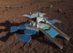
Evropská kosmická agentura vybrala vědecké přístroje pro přistávací platformu mise ExoMars 2018. Mezi šesti vybranými experimenty je vlnový analyzátor WAM pro měření změn magnetického pole, jehož návrh předložil vědecký tým Ústavu fyziky atmosféry AV ČR. Sonda i s českým vědeckým přístrojem se k Marsu vydá 7. května 2018.
AG5 Uses AECOsim Building Designer for Comprehensive Building Information Modeling
20.11.2015 15:47 Bentley SystemsSentinel-3A on its way
20.11.2015 14:43 ESA Observing the Earth
The latest satellite for the European Commission’s Copernicus environmental programme has left France bound for the Plesetsk launch site in Russia and launch late next month.
Sentinel-3A je na cestě na kosmodrom
20.11.2015 14:22 Český Kosmický PortálNejnovější družice systému Evropské komise GMES/Copernicus pro monitorování životního prostředí Sentinel-3A opustila Francii a vydala se na ruský kosmodrom Pleseck. Odtud pak má v prosinci letošního roku startovat do vesmíru.
VP_OO6_2014 (1)
20.11.2015 12:59 ČÚZK - předpisy a opatření /Urady/Katastralni-urady/Katastralni-urady/Katastralni-urad-pro-Jihomoravsky-kraj/Katastralni-pracoviste/KP-Znojmo/Uredni-deska/Oznameni-a-jina-uredni-sdeleni/VP_OO6_2014-(1)VP_OO6_2014
20.11.2015 12:55 ČÚZK - předpisy a opatření /Urady/Katastralni-urady/Katastralni-urady/Katastralni-urad-pro-Jihomoravsky-kraj/Katastralni-pracoviste/KP-Znojmo/Uredni-deska/Oznameni-a-jina-uredni-sdeleni/VP_OO6_2014Spanish mosaic
20.11.2015 10:05 ESA Observing the Earth
Earth observation image of the week: a Sentinel-2A image of Merida, Spain, also featured on the Earth from Space video programme
Včerejší GIS Day 2015 jsme strávili přednáškou a ukázkami opět v Liberci
20.11.2015 8:39 UpVision Včera jsme opět po roce strávili na pozvání GIS Day 2015 v Liberci na stejnojmenné výborné akci. Kromě přednášky na téma využití UAV a možnosti jejich nasazení při povodních, které jsme takto použili už v roce 2013, jsme se trochu prolétli v interiéru :-)Více zde:
http://geoportal.kraj-lbc.cz/dny-gis
Fotky zde:
https://plus.google.com/+UpvisionCz1/posts/QRmpSxrxAYA
Letní škola GEOREGNET 2016 ve Štýrském Hradci (Grazu)
20.11.2015 2:37 Katedra geografie UP Olomouc V září 2016 se bude konat 7. letní škola sítě GEOREGNET. Informace o jejím obsahu a logistice naleznete zde. Zájemci hlaste se spolu s krátkým motivačním dopisem do 25.11. na e-mail dr. Ptáčka.Aktualizace závazného předpisu ŘSD ČR B2/C1
20.11.2015 2:11 Zeměměřič - Datový předpis pro tvorbu mapových podkladů v rámci ŘSD ČR a pro tvorbu digitálních map komunikací provozovaných ŘSD ČRÚdaje o území
20.11.2015 1:00 Cenia - Katalog metadat ČR - INSPIRE WMS služba zpřístupňuje souhrnné informace pro účely poskytování údajů o území ve smyslu § 27 zákona č. 183/2006 Sb. (stavební zákon) z následujících vrstev: dobývací prostory, chráněná ložisková území, chráněná území pro zvláštní zásahy do zemské kůry, výhradní ložiska a schválené prognózní zdroje, oznámená důlní díla (stará důlní díla), poddolovaná území, sesuvná území, dobývací prostory a ložiska nevyhrazených nerostů.Registr sesuvů - Geofond
20.11.2015 1:00 Cenia - Katalog metadat ČR - INSPIRE WMS služba zobrazuje základní údaje o evidovaných gravitačních pohybech zemského povrchu (sesuvech, proudech, odvalech a blokových posuvech). Registr sesuvů vznikl v šedesátých letech v Geofondu a do konce roku 2010 byl plněn výsledky ze zpráv a projektů jak státních, tak posléze i soukromých organizací. Registr sesuvů obsahuje 9 323 záznamů - objektů. Od 1.1.2011 není dále doplňován. U oblastí, které byly podrobně vymapovány (Registr svahových nestabilit) slouží tato data jako historická. V nemapovaných oblastech se jedná o prozkoumanost gravitačních pohybů.Údaje o území
20.11.2015 1:00 Cenia - Katalog metadat ČR - INSPIRE ArcGIS Server služba zpřístupňuje souhrnné informace pro účely poskytování údajů o území ve smyslu § 27 zákona č. 183/2006 Sb. (stavební zákon) z následujících vrstev: dobývací prostory, chráněná ložisková území, chráněná území pro zvláštní zásahy do zemské kůry, výhradní ložiska a schválené prognózní zdroje, oznámená důlní díla (stará důlní díla), poddolovaná území, sesuvná území, dobývací prostory a ložiska nevyhrazených nerostů.Oznámení o vyhlášení výběrového řízení na služební místo odborný rada odboru personálního, oddělení řízení lidských zdrojů
20.11.2015 0:00 Státní pozemkový úřadNew satellite to measure plant health
19.11.2015 14:29 ESA Observing the Earth
ESA plans to track the health of the world’s vegetation by detecting and measuring the faint glow that plants give off as they convert sunlight and the atmosphere’s carbon dioxide into energy.
Kosmonaut Thomas Pesquet je blíže vesmíru: jeho mise dostala jméno Proxima
19.11.2015 14:20 Český Kosmický PortálPříští rok v listopadu se kosmonaut ESA Thomas Pesquet vydá na půlroční výpravu na Mezinárodní kosmickou stanici. Už dnes ale zná její název - a má její logo.
Kosmonaut Thomas Pesquet je blíže vesmíru: jeho mise dostala jméno Proxima
19.11.2015 14:20 Český Kosmický PortálPříští rok v listopadu se kosmonaut ESA Thomas Pesquet vydá na půlroční výpravu na Mezinárodní kosmickou stanici. Už dnes ale zná její název - a má její logo.
Earth from Space
19.11.2015 14:00 ESA Observing the EarthJoin us on Friday, 20 November, at 10:00 CET for the "Earth from Space" video programme. This week features a Sentinel-2A image of Merida, Spain
Earth from Space
19.11.2015 13:45 ESA Observing the Earth
Join us on Friday, 20 November, at 10:00 CET for the "Earth from Space" video programme. This week features a Sentinel-2A image of Merida, Spain
RSS KGK SR není validní
19.11.2015 12:00 Komora geodetů a kartografů SR Společnost Duomedia.sk, výrobce webových stránek KGK, byla požádána o opravu RSS kanálu.The Internet of Things: Cloud-based Services and Smart Living
19.11.2015 10:13 European GNSS AgencyTo highlight the essential role GNSS plays in the developing area of the Internet of Things, the European GNSS Agency (GSA) recently participated in four global events on the topic.
The Internet of Things (IoT) refers to a major development in the role of the Internet: the interconnectivity of uniquely identifiable devices. Beyond improving productivity and efficiency of organizations, IoT solutions are opening a new set of applications in almost every sector of the economy. The IoT network can connect anything ranging from personal cell phones, tablets and PCs to smart roads, smart shelf signage and smart appliances.
While GNSS is integral to the Internet of Things, its role is often downplayed as an element within smart applications. To raise awareness of its role and to ensure that European GNSS programmes will be considered as important players in this potentially massive global market, the GSA recently took a closer look at the market trends surrounding the Internet of Things.
The Essential Role of GNSS
At World Smart Week, an annual event dedicated to smart, connected services and innovation, the GSA took part in a panel discussion entitled ‘Geo-Location, the Beating Heart of IoT’. The discussion highlighted how location based services and timing information, using GNSS, will become increasingly important for IoT applications. For example, the improved accuracy and overall performance created by multi-constellation systems means GNSS will move from being a sensor to actually controlling the ‘things’, including UAVs and connected cars.
In Prague, at the IOT Forum, over 200 representatives of Czech companies gathered to discuss the role of IoT in industry. The GSA joined Vodafone, EMC, BMW, IDC, Robodrone and others for a panel discussion on the evolution of IoT. Specifically, the GSA explained how the technology enabling IoT relies heavily on sensors that connect the physical and digital worlds. As such, Galileo sensors will play an important role in providing valuable information on location, velocity and time.
At the TechUK Satellite Applications and Services Conference, the focus was on how new developments in satellite technology are expanding the scope of applications. New developments in satellite technology are finding applications not only in the traditional sectors of broadcasting, communications, navigation, earth observation and defence, but across the wider economy, including transport and healthcare. Speaking at the conference, the GSA stressed that European GNSS is an enabler of IoT, pointing to the ITS sector as an example where Galileo will provide better positioning accuracy and signal authentication.
Last but not least, at a seminar hosted by GNSS.asia in Taipei entitled ‘Smart X: When GNSS Meets the Internet of Things”, the GSA joined a variety of institutional and industrial experts from the EU and Taiwan. The event was an excellent opportunity to build a solid team of EU and Asian industrial professionals and GNSS experts, the GNSS.asia project seeks to develop relationships, networking opportunities, and increased visibility to Asian markets.
The Message is Clear
From these various events – across sectors and countries - the message is clear: European GNSS provides a level of reliability, precision and robustness that can help expand the Internet of Things and its benefits throughout the EU and beyond. By allowing for the development of new applications, in addition to the improvement of existing applications, European GNSS will provide new avenues of economic opportunity to EU countries, businesses and citizens via IoT.
Media note: This feature can be republished without charge provided the European GNSS Agency (GSA) is acknowledged as the source at the top or the bottom of the story. You must request permission before you use any of the photographs on the site. If you republish, we would be grateful if you could link back to the GSA website (http://www.gsa.europa.eu).

Konference GIS Esri v ČR – co nás zaujalo
19.11.2015 7:00 GISportal.cz A dnes už jen v krátkosti, co zaujalo reportéry GISportálu (seřazeno náhodně): Výběr témat a keynote řečníků HZS: “Vykrádáme co můžeme (data)…a jenom to co nemůžeme, kupujeme” Živá ukázka výjezdových tabletů HZS Výstava techniky před kongresovým centrem ArcGIS Earth – škoda ...Registr sesuvů - Geofond
19.11.2015 1:00 Cenia - Katalog metadat ČR - INSPIRE WMS služba zobrazuje základní údaje o evidovaných gravitačních pohybech zemského povrchu (sesuvech, proudech, odvalech a blokových posuvech). Registr sesuvů Geofondu ukončil svou činnost k 31.12.2010 a obsahuje celkem 9 323 záznamů - objektů. Od roku 2011 je zveřejněna postupná revize těchto záznamů detailním terénním mapováním, a to v Registru svahových nestabilit ČGS.Registr svahových nestabilit
19.11.2015 1:00 Cenia - Katalog metadat ČR - INSPIRE WMS služba zobrazuje detailně vymapované svahové nestability (sesuvy aj.) v měřítku 1:10 000 na území České republiky. Údaje jsou průběžně aktualizovány a postupně revidují veškeré registrované záznamy z Registru sesuvů-Geofondu, jehož činnost byla ukončena k 31.12.2010.METODIKA ZMÍRNĚNÍ NEGATIVNÍCH DŮSLEDKŮ HYDROLOGICKÝCH EXTRÉMŮ A EROZNÍCH ÚČINKŮ POVRCHOVÉHO ODTOKU AGRÁRNÍMI VALY (Případová studie Verneřice)
18.11.2015 22:22 Asociace poskytovatelů služeb v pozemkových úpravách Prostřednictvím našich stránek bych se chtěl vrátit k některým již dříve zveřejněným, ale dle mého soudu málo rozšířeným, technickým podkladům projekční praxe, využitelných v oboru pozemkových úprav. Dnes bych chtěl připomenout metodiku, která je výsledkem řešení výzkumného projektu MZe ČR NAZV 08-82126 „Zajištění harmonizace krajinotvorné, hydrologické a produkční funkce agrárních valů a teras pro diverzifikaci…One Third of Be Inspired Awards Involve Mapping, Managing, Rehabbing and Replacing Aging Infrastructure
18.11.2015 15:40 Bentley SystemsKanada se přidala ke společnému pozemnímu segmentu programu Sentinel
18.11.2015 14:19 Český Kosmický PortálESA a Kanadská kosmická agentura (Canadian Space Agency, CSA) podepsaly dohodu, která umožňuje širší přístup k družicovým datům z misí Sentinel uživatelům v Kanadě.
Kanada se přidala ke společnému pozemnímu segmentu programu Sentinel
18.11.2015 14:19 Český Kosmický PortálESA a Kanadská kosmická agentura (Canadian Space Agency, CSA) podepsaly dohodu, která umožňuje širší přístup k družicovým datům z misí Sentinel uživatelům v Kanadě.
20151118-seznam ÚOZI
18.11.2015 14:18 ČÚZK - předpisy a opatření /Aktuality-resort/20151118-seznam-UOZI20151118-seznam ÚOZI
18.11.2015 14:18 ČÚZK - předpisy a opatření /Aktuality-resort/2015/20151118-seznam-UOZIVyhlášení platnosti obnoveného operátu - Řehlovice
18.11.2015 14:13 ČÚZK /Urady/Katastralni-urady/Katastralni-urady/Katastralni-urad-pro-Ustecky-kraj/Katastralni-pracoviste/KP-Usti-nad-Labem/O-uradu/Aktuality/Vyhlaseni-platnosti-obnoveneho-operatu-RehloviceVyhlášení platnosti obnoveného operátu - Řehlovice
18.11.2015 14:13 ČÚZK - předpisy a opatření /Urady/Katastralni-urady/Katastralni-urady/Katastralni-urad-pro-Ustecky-kraj/Katastralni-pracoviste/KP-Usti-nad-Labem/O-uradu/Aktuality/Vyhlaseni-platnosti-obnoveneho-operatu-RehloviceAssistant Professor in Geodesy and Remote Sensing - USA
18.11.2015 12:02 Assistant Professor in Geodesy and Remote Sensing - University of Colorado Boulder, USACarlo des Dorides Elected to Second Term as GSA Executive Director
18.11.2015 12:00 European GNSS AgencyGSA Administrative Board unanimously votes to keep Carlo des Dorides at the helm of Europe’s satellite navigation agency for another four years.
Carlo des Dorides has been re-elected as the Executive Director of the European GNSS Agency (GSA), following a unanimous vote from the GSA Administrative Board held on 30 October. The Board, comprised of representatives of the 28 EU Member States, elected des Dorides to a second four-year term on 29 October 2015. Per EU Regulation 512/2014, each EU member state has one vote, with four votes given to the European Commission.
“My election has a special significance this time. I was first elected following a one-hour interview by the GSA Administrative Board, but this time it was after five years of performance,” says des Dorides. “The next four years will put into practice all that we have been preparing for over the past five years. In 2017, for example, the Agency will be responsible for the service and operations of Galileo as well as EGNOS, where we have been in charge since 2014.”
As Executive Director, des Dorides sets the vision and goals for the GSA. Specifically, he is charged with ensuring the Agency accomplishes its mission of supporting the effective operation, maintenance and security of Europe’s satellite navigation systems, while guaranteeing optimal service levels and developing applications and services that ensure satellite technology benefits end users.
During his first term, des Dorides was focused on building an organisation that will focus on achieving the greatest return on investment for the Europe’s satellite navigation programmes – a goal he will continue to work toward in his second term.
A Space Orientated Career Path
For the past three decades des Dorides has been managing space service teams. In his role prior to Executive Director of the GSA, he held a management role at the European Commission, and was responsible for the definition of the Galileo/EGNOS exploitation phases.
Previously, he led the Concession Department at the European GNSS Supervisory Authority, and served as Chief Negotiator of the Galileo Public-Private-Partnership/Concession contract at the Galileo Joint Undertaking. This in-depth understanding of Galileo and EGNOS, as well as a career in management, helped him excel in his first term as Executive Director.
From a young age, des Dorides was interested in advanced satellite system management. After obtaining a degree in engineering from the University of Rome, he went on to achieve an M.B.A. from CUOA, Vicenza, Italy, and obtained additional education at the International Space University in Toulouse, France. From there, he worked in management in the aerospace sector, including a position as Head of Advanced Telecommunication Programmes and Programme Manager for major satellite telecommunication projects at Alenia Spazio. Later, he served as Director of Programmes and Engineering at ENAV, the Italian air navigation service provider.
Looking Ahead
Today, des Dorides enters a second term as GSA Executive Director in the midst of an exciting time for the GNSS market. There are currently more than 4 billion devices using GNSS services, and that number is expected to triple by 2023. The sector is estimated to grow at more than 8% each year until at least 2019. With all the potential for GNSS – and in particular European GNSS – in the coming four years, the GSA is looking forward to having des Dorides again at the forefront of Europe’s satellite navigation systems.
Media note: This feature can be republished without charge provided the European GNSS Agency (GSA) is acknowledged as the source at the top or the bottom of the story. You must request permission before you use any of the photographs on the site. If you republish, we would be grateful if you could link back to the GSA website (http://www.gsa.europa.eu).

Carlo des Dorides Elected to Second Term as GSA Executive Director
18.11.2015 12:00 European GNSS AgencyGSA Administrative Board unanimously votes to keep Carlo des Dorides at the helm of Europe’s satellite navigation agency for another four years.
Carlo des Dorides has been re-elected as the Executive Director of the European GNSS Agency (GSA), following a unanimous vote from the GSA Administrative Board held on 30 October. The Board, comprised of representatives of the 28 EU Member States, elected des Dorides to a second four-year term on 29 November 2015. Per EU Regulation 512/2014, each EU member state has one vote, with four votes given to the European Commission.
“My election has a special significance this time. I was first elected following a one-hour interview by the GSA Administrative Board, but this time it was after five years of performance,” says des Dorides. “The next four years will put into practice all that we have been preparing for over the past five years. In 2017, for example, the Agency will be responsible for the service and operations of Galileo as well as EGNOS, where we have been in charge since 2014.”
As Executive Director, des Dorides sets the vision and goals for the GSA. Specifically, he is charged with ensuring the Agency accomplishes its mission of supporting the effective operation, maintenance and security of Europe’s satellite navigation systems, while guaranteeing optimal service levels and developing applications and services that ensure satellite technology benefits end users.
During his first term, des Dorides was focused on building an organisation that will focus on achieving the greatest return on investment for the Europe’s satellite navigation programmes – a goal he will continue to work toward in his second term.
A Space Orientated Career Path
For the past three decades des Dorides has been managing space service teams. In his role prior to Executive Director of the GSA, he held a management role at the European Commission, and was responsible for the definition of the Galileo/EGNOS exploitation phases.
Previously, he led the Concession Department at the European GNSS Supervisory Authority, and served as Chief Negotiator of the Galileo Public-Private-Partnership/Concession contract at the Galileo Joint Undertaking. This in-depth understanding of Galileo and EGNOS, as well as a career in management, helped him excel in his first term as Executive Director.
From a young age, des Dorides was interested in advanced satellite system management. After obtaining a degree in engineering from the University of Rome, he went on to achieve an M.B.A. from CUOA, Vicenza, Italy, and obtained additional education at the International Space University in Toulouse, France. From there, he worked in management in the aerospace sector, including a position as Head of Advanced Telecommunication Programmes and Programme Manager for major satellite telecommunication projects at Alenia Spazio. Later, he served as Director of Programmes and Engineering at ENAV, the Italian air navigation service provider.
Looking Ahead
Today, des Dorides enters a second term as GSA Executive Director in the midst of an exciting time for the GNSS market. There are currently more than 4 billion devices using GNSS services, and that number is expected to triple by 2023. The sector is estimated to grow at more than 8% each year until at least 2019. With all the potential for GNSS – and in particular European GNSS – in the coming four years, the GSA is looking forward to having des Dorides again at the forefront of Europe’s satellite navigation systems.
Media note: This feature can be republished without charge provided the European GNSS Agency (GSA) is acknowledged as the source at the top or the bottom of the story. You must request permission before you use any of the photographs on the site. If you republish, we would be grateful if you could link back to the GSA website (http://www.gsa.europa.eu).
Rozhovor s Martinem Hrdličkou o rodinném podnikání
18.11.2015 12:00 Hrdlička Jak jsme Vás již na našich webových stránkách informovali, společnost HRDLIČKA se umístila na bronzové příčce v soutěži Equa bank Rodinná firma roku. Co stojí za úspěchem firmy prozradil v rozhovoru pro časopis Profit ředitel společnosti Martin Hrdlička.V části Zajímavé stránky byl u
18.11.2015 12:00 Plzeňský kraj V části Zajímavé stránky byl uveřejněn odkaz na Strategické hlukové mapy.V části Zajímavé stránky (http
18.11.2015 12:00 Plzeňský kraj V části Zajímavé stránky (http://geoportal.plzensky-kraj.cz/gs/zajimave-stranky/) byl uveřejněn odkaz na Strategické hlukové mapy (http://szu.maps.arcgis.com/home/).Rozhovor s Martinem Hrdličkou o rodinném podnikání
18.11.2015 9:00 Hrdličkarozhovor_casopis_profit
The post Rozhovor s Martinem Hrdličkou o rodinném podnikání appeared first on HRDLIČKA spol. s r.o. - komplexní služby v oblasti geodézie.
Mapujeme a vytváříme 3D modely největších jihočeských lomů
18.11.2015 7:10 UpVision Mapujeme největší jihočeské lomy. Kromě aktuálních ortofotomap, vytváříme i 3D modely a počítáme kubatury.Na první fotce vykukuje Kleť - nejvyšší hora Blanského lesa nedaleko Českého Krumlova...
Fotky zde:
https://plus.google.com/+UpvisionCz1/posts/dkSCavJG2Bh
Konference GIS Esri v ČR – část třetí
18.11.2015 7:00 GISportal.cz Jednou z prvních sekcí druhého konferenčního dne byl GIS ve zdravotnictví. Po rautu předchozí večer účastníkům jistě přišla vhod přednáška s názvem GIS v IS Pivo od Pavla Junka a Martiny Myšákové ze Zdravotního ústavu ...Carlson Civil Suite for day-to-day CAD design
18.11.2015 3:45 Carlson Software Keeping it Simple with Carlson Civil Suite “There are things that Carlson has that make it easier for us to do what we do. I don’t find that with other software packages,” says Jon Eakins, Senior Project Engineer for the Nau Company, a civil engineering firm located in Wake Forest, North Carolina. Eakins notes that […]Registr svahových nestabilit
18.11.2015 1:00 Cenia - Katalog metadat ČR - INSPIRE WMS služba zobrazující vymapované sesuvy na území České republiky.Modeling Underground Utilities in 3D Reduces Construction Time and Costs
17.11.2015 18:31 Bentley SystemsAECOsim Building Designer Coordinates 3D Design of World’s Tallest Ferris Wheel
17.11.2015 18:07 Bentley Systems
Letní škola GEOREGNET 2016 v Grazu
17.11.2015 14:18 Katedra geografie UP Olomouc V září 2016 se bude konat 7. letní škola sítě GEOREGNET. Informace o jejím obsahu a logistice naleznete zde. Zájemci hlaste se spolu s krátkým motivačním dopisem do 25.11. na e-mail dr. Ptáčka.ČGS – Blok expertů MRS 18. 11. 2015
17.11.2015 11:04 Katedra geografie UP Olomouc Zveme Vás na přednášku v rámci Bloku expertů MRSPovinná školní docházka nomádů z oblasti Čangthang ve východním Ladaku (Indie): Cesta k lepší budoucnosti?
která se uskuteční ve středu 18. listopadu 2015 od 15.00 do 16.30 na učebně LP 5007 Přírodovědecké fakulty UP. Přednáší Lenka Zahrádková (pozvánka).
Expanding Opportunities for Maritime use of GNSS
17.11.2015 10:28 European GNSS AgencyMaritime use of GNSS goes far beyond navigation at sea to include applications for search and rescue, inland waterways, environmental protection and sailing.
The maritime industry was quick to adopt satellite navigation, and an estimated 87% of merchant shipping already uses global satellite systems for navigation and positioning. About 90% of world trade is carried by sea, and shipping accounts for around 40% of trade between EU-28 countries.
More so, there are more than 50,000 merchant ships over 500 GRT (gross registered tons) trading internationally. And, every year, some 400 million passengers use European ports. With larger ships costing over EUR 100 million to build and cargoes on very large crude carriers (VLCCs) worth over EUR 200 million, the stakes for security, safety and efficiency are high.
As a result, there is now rapidly growing interest in the huge potential of GNSS for leisure craft users, coastal navigation, search and rescue operations and navigation on inland waterways - especially in conjunction with a space-based augmentation system (SBAS) like the European Geostationary Navigation Overlay Service (EGNOS).
These are some of the forecasts contained in the latest edition of the GSA GNSS Market Report.
Multiple constellations and the challenges of accuracy and resilience
GNSS has radically changed maritime navigation, whether on board the largest super-tankers and container ships, which often have two or more receivers for redundancy, or on small leisure craft using inexpensive handsets. In fact, GNSS has become the main source of position and timing information for the integrated Electronic Chart Display and Information Systems (ECDIS) that are used on merchant ships.
However, the widespread uptake of GNSS for commercial shipping has raised the need for common standards for performance, reliability and resilience across and within constellations. With the susceptibility of the GNSS signal to interruptions in the availability of any given constellation, the ability of receivers to process signals from more than one constellation is obviously an advantage.
The International Maritime Organisation (IMO) recognises the core GNSS constellations as part of the World Wide Radio Navigation System (WWRNS), and Galileo is currently pending approval. Galileo dual frequency receivers will be compliant with the accuracy levels required for navigation in ocean and coastal waters, harbour entrances and harbour approaches - with a Horizontal Navigation System Error of less than 10 metres, with a probability of 95%.
The GNSS signal is also vulnerable to interference (whether natural, because of reflections and canyons caused by port infrastructure and other shipping, or deliberate jamming and spoofing), emphasizing the need for shipping to integrate a complementary back-up navigation system. IMO is developing multisystem performance standards for ship-borne receivers, and the need to integrate the different available and future satellite navigation systems, as well as terrestrial systems (such as e-Loran) and augmentation systems (like DGPS or SBAS).
The IMO eNavigation Strategy Implementation Plan (SIP), which was approved by its Maritime Safety Committee in November 2014, is looking to optimize the integration of these complementary sources of PNT data with standards for an ergonomic, resilient and reliable common bridge display.
Coastal navigation, port approaches and inland waterways
GNSS is much more than a source of globally accessible PNT information for mariners in the open sea. When combined with SBAS, GNSS can provide accurate and reliable positioning, not just for ocean navigation, but also in port approaches, inland waterways and restricted waters. The signal can be used both on board and by shore-based VTS to assist port operations, traffic management and collision avoidance. SBAS-enabled GNSS is also commonly used in conjunction with DGPS and RTK in Portable Pilot Units (PPUs) to bring even the largest VLCCs and container vessels from deep draught channels at sea, all the way to berth.
GNSS is one of the key sources of position information for Automatic Identification System (AIS) transponders, which exchange information with nearby ships and land-based vessel traffic services (VTS) on a vessel’s position, course and speed. AIS is mandatory on international shipping over 300 GRT, all cargo ships over 500 GRT, all passenger ships as well as fishing vessels over 15 m in length, under IMO regulation 19 of SOLAS Chapter V.
The AIS ground-based infrastructure can also be used to transmit SBAS correction signals, such as EGNOS, as a complementary source of accurate position information to overcome current issues of signal availability on some inland waterways. With around 37,000 km of inland waterways connecting European cities and industrial regions, the potential for increased safety and efficiency is considerable - over 520 million tonnes of freight were carried on EU-27 inland waterways in 2011 and the global inland waterways fleet is estimated at around 529,000 vessels.
Leisure craft, search and rescue
There are an estimated 29.2 million recreational vessels globally. Although they are not required to carry minimum navigational equipment under SOLAS, around 22% do have some form of GNSS receiver on board, many EGNOS-enabled – often without the skipper even knowing it. According to the latest GSA GNSS Market Report, annual shipments of GNSS receivers for recreational navigation are likely to double from 1.15 million units in 2013, to 2 million units in 2013. Skippers, says the report, like to have technological aids to navigation with them, but often choose hand-held and non-professional devices.
By integrating accurate GNSS position information into distress beacon signals, GNSS is also revolutionising search and rescue (SAR) operations. By 2020, all Cospas-Sarsat Emergency Position Indicating Radio Beacons (EPIRBs) and Personal Location Beacons (PLBs) are expected to be using precise GNSS positioning, helping to reduce response times and save lives. In Galileo-enabled beacons, the Galileo return link service will reassure the navigator that the signal has been received and that help is on its way.
Surveillance and environmental protection
Combined with SBAS, GNSS can be used to monitor and protect environmentally vulnerable areas, such as marine parks, and to monitor and prevent illegal fishing. Around 5 million tonnes of fish are caught each year by the EU fleet of 87,500 fishing vessels. As a result of legislation under the EU Common Fisheries Policy, some 9,000 fishing vessels in the European fleet are now fitted with GNSS-enabled vessel monitoring system (VTM) devices, alongside mandatory AIS transponders. These complementary systems allow a close watch to be kept on illegal fishing.
SBAS-enabled GNSS is also enabling vessel traffic services to play a greater role in offering navigational assistance in confined waters and to help improve efficiency of port operations. And SBAS-enabled GNSS can be used to track containers in busy terminals, such as the port of Antwerp, where a joint initiative with Septentrio uses EGNOS, with specially developed firmware linked to yard-management software. Tracking containers from pick-up to drop-off the EGNOS-enabled Septentrio system can even remotely control the straddle carriers and gantry cranes, greatly improving efficiency.
Media note: This feature can be republished without charge provided the European GNSS Agency (GSA) is acknowledged as the source at the top or the bottom of the story. You must request permission before you use any of the photographs on the site. If you republish, we would be grateful if you could link back to the GSA website (http://www.gsa.europa.eu).

ádost o sponzorský dar - SPZem
17.11.2015 8:06 Zeměměřič Jménem studentů 4. ročníků SP zeměměřické si Vás dovoluji oslovit se ádostí o sponzorský dar na maturitní ples, který se bude konat 3. 3. 2016 v Lidovém domě Kbely v ulici Touimská v Praze 19 od 19 hodin.INSPIRE téma Budovy (BU)
17.11.2015 1:00 Cenia - Katalog metadat ČR - INSPIRE Data odpovídají směrnici INSPIRE pro téma budovy (BU). Data pochází částečně z projektu RÚIAN (Registr územní identifikace, adres a nemovitostí), který je součástí základních registrů České Republiky a obsahuje informace o územní identifikaci, adresách a nemovitostech, a částečně z ISKN (Informační systém katastru nemovistostí). Zdrojem informací o budovách v ISKN je objekt Stavba, v RÚIAN je to Stavební objekt. Většina Staveb je zároveň Stavebními objekty, ale jsou případy, kdy tomu tak není. Kromě Budov datová sada obsahuje i části budov, které jsou pro potřeby INSPIRE vyjádřeny vchody z RÚIAN. Vchody obsahují informace o počtu podlaží, technickoekonomických atributech apod. Datová sada pokrývá celé území české republiky. V datové sadě není uvedeno 7,43%, t.j. 321054 budov (k 16. 11. 2015), protože neobsahují definiční bod ani polygon. Více v zákoně č. 111/2009 Sb., o základních registrech, ve vyhlášce č. 359/2011 Sb., o základním registru územní identifikace, adres a nemovitostí v platných zněních, v zákoně 256/2013 Sb., o katastru nemovitostí, v katastrální vyhlášce č. 357/2013 Sb. v platném znění a INSPIRE Data Specification on Buildings v 3.0 z 13.12.2013.INSPIRE téma Parcely (CP)
17.11.2015 1:00 Cenia - Katalog metadat ČR - INSPIRE Data odpovídají směrnici INSPIRE pro téma katastrální parcely (CP). Vychází z katastrální mapy, která je závazným státním mapovým dílem velkého měřítka, obsahuje body polohového bodového pole, polohopis a popis a může mít formu digitální mapy, analogové mapy nebo digitalizované mapy. Data publikovaná v rámci INSPIRE obsahují pouze katastrální území (pro celou Českou Republiku) a parcely a jejich hranice z území, kde je digitální mapa (k 16. 11. 2015 je to 79,47% území České republiky, t.j. 62 672,84km2). Více katastrální zákon 256/2013 Sb., katastrální vyhláška č.357/2013 Sb. v platném znění a INSPIRE Data Specification on Cadastral Parcels v 3.0.1.INSPIRE téma Adresy (AD)
17.11.2015 1:00 Cenia - Katalog metadat ČR - INSPIRE Data odpovídají směrnici INSPIRE pro téma adresy (AD). Vychází především z projektu RÚIAN (Registr územní identifikace, adres a nemovitostí), který je součástí základních registrů České Republiky a obsahuje informace o územní identifikaci, adresách a nemovitostech. Data publikovaná v rámci INSPIRE obsahují pouze adresní místa a jejich komponenty, kterými jsou stát, obec, část obce, městský obvod v Praze (MOP), městký obvod/městská část (MO/MČ), ulice a pošta a to na území celé České Republiky. Obsahují rozvněž geometrii, která určuje definiční bod adresního místa. V datové sadě nění uvedeno 3,20%, t.j. 92897 adresních míst (k 16. 11. 2015), protože neobsahují definiční bod, podle kterého by je bylo možné prostorově určit. Více v zákoně č. 111/2009 Sb., o základních registrech a ve vyhlášce č. 359/2011 Sb., o základním registru územní identifikace, adres a nemovitostí v platných zněních a INSPIRE Data Specification on Addresses v 3.0.1 z 26.4.2010.Pozemkové úpravy - nástroj na riešenie rozdrobenosti pozemkového vlastníctva, revitalizáciu krajiny a rozvoj vidieka
16.11.2015 18:41 Komora pozemkových úprav SR
Propagačná brožúra o pozemkových úpravách vo formáte PDF.
Pozemkové úpravy - nástroj na riešenie rozdrobenosti pozemkového vlastníctva, revitalizáciu krajiny a rozvoj vidieka
16.11.2015 18:41 Komora pozemkových úprav SR Propagačná brožúra o pozemkových úpravách vo formáte PDFDruhý firemní hackathon v CleverMaps
16.11.2015 18:24Na základě kladných reakcí na první interní hackathon, který proběhl 14. – 15. května jsme se rozhodli, že určitě znovu nějaký uspořádáme. A tak po půl roce se na dva dny (12. - 13. 11.) sjeli do brněnské kanceláře zase všichni programátoři a začal náš druhý firemní hackathon.
Tentokrát byly témata zaměřena tak, aby výsledky z hackathonu byly prospěšné pro všechny týmy a produkty CleverMaps. Vybrala se tedy tři nezávislá témata na mapu a jedno téma se zaměřilo na mobilní aplikaci.

K úspěšnému hackathonu ale nestačí jen mysl a rychlé prsty na klávesnici a tak o plné žaludky a pitný režim našich programátorů bylo s láskou postaráno. O jídlo, pití a dobrou atmosféru se skvěle postarala dámská část týmu.
Atmosféra společného úsilí a práce byla vyloženě nakažlivá a pracovalo se dlouho do noci. A brzo ráno se zase zasedalo za stroje a pokračovalo se v práci. Někteří se nezdržovali ani vylézáním ze spacáku a rovnou se vrhli na práci.

V rámci pátečního vyhlášení představili všechny týmy výsledky své dvoudenní práce a mezi sebou pak hlasovali pro vítěze hackathonu. Tím se nakonec stal tým ve složení Martin Tesař a Jiří Žaloudek zabývající se využitím vektorových dlaždic v mapě.

