


![]()

zprávy
zdroje zpráv:Prodej vozidla Škoda Fabia combi, RZ 5A9 6846
1.3.2024 10:50 ČÚZK /Urady/Katastralni-urady/Katastralni-urady/Katastralni-urad-pro-Jihomoravsky-kraj/Nabidky-majetku/Prodej-vozidla-Skoda-Fabia-combi,-RZ-5A9-6846-(1)Prodej vozidla Škoda Fabia combi, RZ 5A9 3007
1.3.2024 10:49 ČÚZK /Urady/Katastralni-urady/Katastralni-urady/Katastralni-urad-pro-Jihomoravsky-kraj/Nabidky-majetku/Prodej-vozidla-Skoda-Fabia-combi,-RZ-5A9-3007-(1)Prodej vozidla Škoda Fabia combi, RZ 5A9 3007
1.3.2024 10:49 ČÚZK - předpisy a opatřeníKatastrální úřad pro Jihomoravský kraj nabízí nepotřebný majetek k odkupu. Jedná se o
Prodej vozidla Škoda Fabia combi, RZ 5A9 3007
Earth from Space: Dawson-Lambton Glacier home to penguins
1.3.2024 10:00 ESA Observing the Earth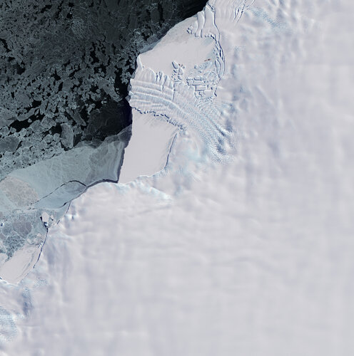 Image:
This Copernicus Sentinel-2 image features the ice tongue of the Dawson-Lambton Glacier in Antarctica.
Image:
This Copernicus Sentinel-2 image features the ice tongue of the Dawson-Lambton Glacier in Antarctica.
Odstávka INT1 od 1.3.2024
29.2.2024 21:36 ČÚZK - předpisy a opatření Český úřad zeměměřický a katastrální upozorňuje, že v termínu od 1. do 11. března 2024 bude z provozních důvodů nedostupné integrační prostředí INT1 IS DMVS. Důvodem odstávky je přechod napojených testovacích instancí IS DTM krajů na novou verzi JVF DTM 1.4.3 a s tím spojené nutné úpravy v těchto informačních systémech. Po opětovném zprovoznění bude v prostředí INT1 k dispozici nová verze 1.6.1.3 IS DMVS (která oproti aktuální verzi obsahuje důležitou změnu v pojmenování odesílaných JVF - soubory obsahující data ve formátu JVF musí mít příponu .jvf.xml) a avizovaná nová verze JVF DTM 1.4.3.Doporučujeme vývojářům IS VSP, aby na tuto konfiguraci připravili svá vývojová prostředí tak, aby mohli úpravy včas otestovat a nasadit i na produkční prostředí.
How will space transform the global food system?
29.2.2024 16:00 ESA Observing the EarthAccording to the Food and Agriculture Organization (FAO), global agricultural production will need to increase by 60% by 2050 to meet the food demands of the growing global population.
A new satellite called Copernicus Hyperspectral Imaging Mission for the Environment, or CHIME, is being developed to support EU policies on the management of natural resources – ultimately helping to address the global issue of food security.
CHIME will carry a unique visible to shortwave infrared spectrometer to provide routine hyperspectral observations to support new and enhanced services for sustainable agricultural and biodiversity management, as well as soil property characterisation.
CHIME is one of six Copernicus Sentinel Expansion missions that ESA is developing on behalf of the EU. The missions will expand the current capabilities of the Copernicus Space Component – the world’s biggest supplier of Earth observation data.
This video features interviews with Marco Celesti, CHIME Mission Scientist and Jens Nieke, CHIME Project Manager.
Access all "Unpacking Sentinels" videos.
Prodej kovových regálů
29.2.2024 13:42 ČÚZK - předpisy a opatřeníKatastrální úřad pro hlavní město Prahu nabízí nepotřebný majetek k odkupu. Jedná se o
Prodej kovových regálů
Prodej kovových regálů
29.2.2024 13:42 ČÚZK /Urady/Katastralni-urady/Katastralni-urady/Katastralni-urad-pro-hlavni-mesto-Prahu/Nabidky-majetku/Prodej-kovovych-regaluProdej tonerů
29.2.2024 13:40 ČÚZK - předpisy a opatřeníKatastrální úřad pro hlavní město Prahu nabízí nepotřebný majetek k odkupu. Jedná se o
Prodej tonerů
Prodej tonerů
29.2.2024 13:40 ČÚZK /Urady/Katastralni-urady/Katastralni-urady/Katastralni-urad-pro-hlavni-mesto-Prahu/Nabidky-majetku/Prodej-tonerubSI & OGC Roadmap Webinar
29.2.2024 13:40 buildingSMART.orgDate: 22nd February 2024 Speakers: Marc Goldman, Jagannath Mallela, Abhishek Bhargava, Francesca Noardo, Michel Rives and Erik Poirer. This webinar presents insights from members of the working group regarding the…
The post bSI & OGC Roadmap Webinar appeared first on buildingSMART International.
 Image:
GENESIS mission patch
Image:
GENESIS mission patch
Výroční zpráva dle zákona č. 106/1999 Sb. za rok 2023
29.2.2024 11:40 ČÚZK /Urady/Katastralni-urady/Katastralni-urady/Katastralni-urad-pro-Zlinsky-kraj/Vyrocni-zpravy/Vyrocni-zprava-dle-zakona-c-106-1999-Sb-za-rok-(5)Výroční zpráva dle zákona č. 106/1999 Sb. za rok 2023
29.2.2024 11:40 ČÚZK - předpisy a opatření Katastrální úřad pro Zlínský krajvydává výroční zprávu úřadu za rok
2023
20240229_Rada / odborný rada oddělení právních vztahů k nemovitostem
29.2.2024 11:19 ČÚZK /Urady/Katastralni-urady/Katastralni-urady/Katastralni-urad-pro-Stredocesky-kraj/Katastralni-pracoviste/KP-Beroun/O-uradu/Aktuality/20210922_Odborny-referent-oddeleni-aktualizac-(2)20240229_Rada / odborný rada oddělení právních vztahů k nemovitostem
29.2.2024 11:19 ČÚZK - předpisy a opatření Katastrální úřad pro Středočeský kraj - Katastrální pracoviště Beroun Vyhlášení výběrového řízení: Rada / odborný rada oddělení právních vztahů k nemovitostem V části "Úřední deska", v sekci "Oznámení a jiná úřední sdělení" bylo vystaveno "Oznámení o vyhlášení výběrového řízení na obsazení služebního místa Rada / odborný rada oddělení právních vztahů k nemovitostem"Rada / odborný rada oddělení právních vztahů k nemovitostem
29.2.2024 11:18 ČÚZK - předpisy a opatření Katastrální úřad pro Středočeský kraj Katastrální pracoviště Berounvypisuje výběrové řízení na místo
Rada / odborný rada oddělení právních vztahů k nemovitostem
Rada / odborný rada oddělení právních vztahů k nemovitostem
29.2.2024 11:18 ČÚZK - volná místa Katastrální úřad pro Středočeský kraj Katastrální pracoviště Beroun vypisuje výběrové řízení na místo Rada / odborný rada oddělení právních vztahů k nemovitostemOrganizovali jsme společně s Velvyslanectvím USA roundtable s americkým velvyslancem k dronům
29.2.2024 11:13 UAVA Organizovali jsme společně s Velvyslanectvím USA roundtable s americkým velvyslancem k dronům a v rámci přípravy českého stánku opět na největší světové akci na drony a autonomní systémy Xponential 2024, která se letos koná v San Diegu.Organizovali jsme společně s Velvyslanectvím USA roundtable s americkým velvyslancem k dronům
29.2.2024 11:13 UAVA Organizovali jsme společně s Velvyslanectvím USA roundtable s americkým velvyslancem k dronům a v rámci přípravy českého stánku opět na největší světové akci na drony a autonomní systémy Xponential 2024, která se letos koná v San Diegu.20240229_Odborný referent oddělení aktualizace PI KN I.
29.2.2024 10:29 ČÚZK /Urady/Katastralni-urady/Katastralni-urady/Katastralni-urad-pro-Stredocesky-kraj/Katastralni-pracoviste/KP-Praha-zapad/O-uradu/Aktuality/20210922_Odborny-referent-oddeleni-aktualizac-(3)20240229_Odborný referent oddělení aktualizace PI KN I.
29.2.2024 10:29 ČÚZK - předpisy a opatření Katastrální úřad pro Středočeský kraj - Katastrální pracoviště Praha-západ Vyhlášení výběrového řízení: Odborný referent oddělení aktualizace PI KN I. V části "Úřední deska", v sekci "Oznámení a jiná úřední sdělení" bylo vystaveno "Oznámení o vyhlášení výběrového řízení na obsazení služebního místa Odborný referent oddělení aktualizace PI KN I."Odborný referent oddělení aktualizace PI KN I.
29.2.2024 10:28 ČÚZK - volná místa Katastrální úřad pro Středočeský kraj Katastrální pracoviště Praha-západ vypisuje výběrové řízení na místo Odborný referent oddělení aktualizace PI KN I.Odborný referent oddělení aktualizace PI KN I.
29.2.2024 10:28 ČÚZK - předpisy a opatření Katastrální úřad pro Středočeský kraj Katastrální pracoviště Praha-západvypisuje výběrové řízení na místo
Odborný referent oddělení aktualizace PI KN I.
Odborný referent oddělení aktualizace PI KN I.
29.2.2024 10:28 ČÚZK /Urady/Katastralni-urady/Katastralni-urady/Katastralni-urad-pro-Stredocesky-kraj/Uredni-deska/Oznameni-a-jina-uredni-sdeleni/Volna-mista/DMS/Odborny-referent-oddeleni-aktualizace-PI-KN-IVýběrové řízení na KÚ pro Vysočinu
29.2.2024 9:18 ČÚZK - předpisy a opatření Katastrální úřad pro Vysočinu - Katastrální pracoviště Žďár nad Sázavou zveřejnil novou aktualitu: Oznámení o vyhlášení výběrového řízení na služební místo vrchní referent/rada - oddělení obnovy katastrálního operátu II Technického odboru na Katastrálním úřadu pro Vysočinu, místo výkonu služby Žďár nad Sázavou.Výběrové řízení na KÚ pro Vysočinu
29.2.2024 9:18 ČÚZK /Urady/Katastralni-urady/Katastralni-urady/Katastralni-urad-pro-Vysocinu/O-uradu/Aktuality/Vyberove-rizeni-na-KU-pro-Vysocinu-(2)vrchní referent-rada - obnova KO II Technický odbor
29.2.2024 8:59 ČÚZK /Urady/Katastralni-urady/Katastralni-urady/Katastralni-urad-pro-Vysocinu/Uredni-deska/Oznameni-a-jina-uredni-sdeleni/Volna-mista/DMS/vrchni-referent-rada-obnova-KO-II-Technicky-odborvrchní referent-rada - obnova KO II Technický odbor
29.2.2024 8:59 ČÚZK - předpisy a opatření Katastrální úřad pro Vysočinu technický odborvypisuje výběrové řízení na místo
vrchní referent-rada - obnova KO II Technický odbor
vrchní referent-rada - obnova KO II Technický odbor
29.2.2024 8:59 ČÚZK - volná místa Katastrální úřad pro Vysočinu technický odbor vypisuje výběrové řízení na místo vrchní referent-rada - obnova KO II Technický odborNový QGIS 3.36 – Maidenhead
28.2.2024 22:16 GISportal.cz
Další nová verze populárního open-source geografického informačního systému QGIS byla zveřejněna – tentokrát pod číslem 3.36 a názvem Maidenhead. Nová verze přináší opět mnoho vylepšení a také jeden „downgrade“. Z důvodu nedostatečné údržby byl z QGIS odstraněn plugin Orfeo ToolBox (OTB), což je knihovna zpracovávající datelitní DPZ data. Velkou pozitivní novinkou je nová funkce „Movie […]
The post Nový QGIS 3.36 – Maidenhead appeared first on GISportal.cz.
20240228 - VŘ Agenda VZ a smluv
28.2.2024 16:12 ČÚZK - předpisy a opatření Český úřad zeměměřický a katastrální zveřejnil novou aktualitu: Oznámení o vyhlášení výběrového řízení na obsazení služebního místa odborný rada - Agenda VZ a smluv.20240228 - VŘ Agenda VZ a smluv
28.2.2024 16:12 ČÚZK - aktuality v resortu Oznámení o vyhlášení výběrového řízení na obsazení služebního místa odborný rada - Agenda VZ a smluv.20240228 - VŘ Agenda VZ a smluv
28.2.2024 16:12 ČÚZK /Aktuality-resort/2024/20240228-VR-Agenda-VZ-a-smluvVrchní referent / rada - návrh zápisu v katastru v oddělení aktualizace KN Katastrálního pracoviště
28.2.2024 13:29 ČÚZK /Urady/Katastralni-urady/Katastralni-urady/Katastralni-urad-pro-Zlinsky-kraj/Uredni-deska/Oznameni-a-jina-uredni-sdeleni/Volna-mista/DMS/Vrchni-referent-rada-navrh-zapisu-v-katastru-v-oddVrchní referent / rada - návrh zápisu v katastru v oddělení aktualizace KN Katastrálního pracoviště
28.2.2024 13:29 ČÚZK - volná místa Katastrální úřad pro Zlínský kraj Katastrální pracoviště Zlín vypisuje výběrové řízení na místo Vrchní referent / rada - návrh zápisu v katastru v oddělení aktualizace KN Katastrálního pracovištěVrchní referent / rada - návrh zápisu v katastru v oddělení aktualizace KN Katastrálního pracoviště
28.2.2024 13:29 ČÚZK - předpisy a opatření Katastrální úřad pro Zlínský kraj Katastrální pracoviště Zlínvypisuje výběrové řízení na místo
Vrchní referent / rada - návrh zápisu v katastru v oddělení aktualizace KN Katastrálního pracoviště Zlín
Oznámení o vyhlášení VŘ na služební místo rada - odborný rada
28.2.2024 12:51 ČÚZK - předpisy a opatření Zeměměřický a katastrální inspektorát v Praze zveřejnil novou aktualitu: Zeměměřický a katastrální inspektorát v Praze vyhlašuje výběrová řízení na služební místa Rada/Odborný rada inspektor (obor služby 55).Novinky v aplikacích Geoprohlížeč a Archiv
28.2.2024 9:00 ČÚZK - Geoportál Novinky v aplikaci GeoprohlížečDialog "Rozšířené hledání" nabízí nyní Jednodušší a rychlejší vyhledávání parcel.
Pro export dat podle zadání vlastního rozsahu stačí nyní kliknout v mapovém okně na polygon (plochu), a pokud je v Seznamu vrstev produkt, který funkci Export dat umožňuje, nabídne se použití označené geometrie přímo ve vyskakovacím okně. Takto lze využít kromě plošného prvku vektorové mapy například i připojený klad mapových listů nebo katastrálních území, případně polygon z vlastní připojené geometrie. Tato možnost je dostupná pouze pro polygony větší než 1 km2;.
Po kliknutí do mapového okna při prohlížení katastrální mapy se kromě Nahlížení do KN v mapě zobrazí zároveň polygon parcely a ve vyskakovacím okně výměra a druh číslování.
Pro WMTS služby je nyní k dispozici možnost změny stylu (pokud jsou ve službě definovány). Styl služby je možné měnit v Seznamu vrstev i během prohlížení.
Nově je možné připojit externí REST služby typu Indexed Mesh.
Seznam vrstev umožňuje filtrovat vrstvy a také měnit jejich pořadí pomocí Drag&Drop.
Novinky v aplikaci Archiv:
Objednávku Indikačních skic lze vytvořit přímo při prohlížení skici klikání na jednotlivé sekce.
Aplikace byly přepracovány na novou verzi ArcGIS Maps SDK for JavaScript 4.29.
Novinky v aplikaci Geoprohlížeč a Archiv
28.2.2024 9:00 ČÚZK - Geoportál Novinky v aplikaci GeoprohlížečDialog "Rozšířené hledání" nabízí nyní Jednodušší a rychlejší vyhledávání parcel.
Pro export dat podle zadání vlastního rozsahu stačí nyní kliknout v mapovém okně na polygon (plochu), a pokud je v Seznamu vrstev produkt, který funkci Export dat umožňuje, nabídne se použití označené geometrie přímo ve vyskakovacím okně. Takto lze využít kromě plošného prvku vektorové mapy například i připojený klad mapových listů nebo katastrálních území, případně polygon z vlastní připojené geometrie. Tato možnost je dostupná pouze pro polygony větší než 1 km2;.
Po kliknutí do mapového okna při prohlížení katastrální mapy se kromě Nahlížení do KN v mapě zobrazí zároveň polygon parcely a ve vyskakovacím okně výměra a druh číslování.
Pro WMTS služby je nyní k dispozici možnost změny stylu (pokud jsou ve službě definovány). Styl služby je možné měnit v Seznamu vrstev i během prohlížení.
Nově je možné připojit externí REST služby typu Indexed Mesh.
Seznam vrstev umožňuje filtrovat vrstvy a také měnit jejich pořadí pomocí Drag&Drop.
Novinky v aplikaci Archiv:
Objednávku Indikačních skic lze vytvořit přímo při prohlížení skici klikání na jednotlivé sekce.
Aplikace byly přepracovány na novou verzi ArcGIS Maps SDK for JavaScript 4.29.
Novinky v aplikacích Geoprohlížeč a Archiv
28.2.2024 9:00 ČÚZK - Geoportál Novinky v aplikaci GeoprohlížečDialog Rozšířené hledání nabízí nyní jednodušší a rychlejší vyhledávání parcel.
Pro export dat podle zadání vlastního rozsahu stačí nyní kliknout v mapovém okně na polygon (plochu), a pokud je v Seznamu vrstev produkt, který funkci Export dat umožňuje, nabídne se použití označené geometrie přímo ve vyskakovacím okně. Takto lze využít kromě plošného prvku vektorové mapy například i připojený klad mapových listů nebo katastrálních území, případně polygon z vlastní připojené geometrie. Tato možnost je dostupná pouze pro polygony větší než 1 km2.
Po kliknutí do mapového okna při prohlížení katastrální mapy se kromě Nahlížení do KN v mapě zobrazí zároveň polygon parcely a ve vyskakovacím okně výměra a druh číslování.
Pro WMTS služby je nyní k dispozici možnost změny stylu (pokud jsou ve službě definovány). Styl služby je možné měnit v Seznamu vrstev i během prohlížení.
Nově je možné připojit externí REST služby typu Indexed Mesh.
Seznam vrstev umožňuje filtrovat vrstvy a také měnit jejich pořadí pomocí Drag&Drop.
Novinky v aplikaci Archiv:
Objednávku Indikačních skic lze vytvořit přímo při prohlížení skici klikání na jednotlivé sekce.
Aktuální seznam podporovaných webových prohlížečů:
Microsoft Edge 118+
Mozilla Firefox 121+
Safari 16+
iOS Safari 16+
Google Chrome 118+
Zároveň je potřeba, aby webový prohlížeč podporoval WebGL2 a byl 64bitový.
Novinky v aplikacích Geoprohlížeč a Archiv
28.2.2024 9:00 ČÚZK - Geoportál Novinky v aplikaci GeoprohlížečDialog "Rozšířené hledání" nabízí nyní Jednodušší a rychlejší vyhledávání parcel.
Pro export dat podle zadání vlastního rozsahu stačí nyní kliknout v mapovém okně na polygon (plochu), a pokud je v Seznamu vrstev produkt, který funkci Export dat umožňuje, nabídne se použití označené geometrie přímo ve vyskakovacím okně. Takto lze využít kromě plošného prvku vektorové mapy například i připojený klad mapových listů nebo katastrálních území, případně polygon z vlastní připojené geometrie. Tato možnost je dostupná pouze pro polygony větší než 1 km2;.
Po kliknutí do mapového okna při prohlížení katastrální mapy se kromě Nahlížení do KN v mapě zobrazí zároveň polygon parcely a ve vyskakovacím okně výměra a druh číslování.
Pro WMTS služby je nyní k dispozici možnost změny stylu (pokud jsou ve službě definovány). Styl služby je možné měnit v Seznamu vrstev i během prohlížení.
Nově je možné připojit externí REST služby typu Indexed Mesh.
Seznam vrstev umožňuje filtrovat vrstvy a také měnit jejich pořadí pomocí Drag&Drop.
Novinky v aplikaci Archiv:
Objednávku Indikačních skic lze vytvořit přímo při prohlížení skici klikání na jednotlivé sekce.
Aplikace byly přepracovány na novou verzi ArcGIS Maps SDK for JavaScript 4.29.
Novinky v aplikacích Geoprohlížeč a Archiv
28.2.2024 9:00 ČÚZK - Geoportál Novinky v aplikaci GeoprohlížečDialog Rozšířené hledání nabízí nyní jednodušší a rychlejší vyhledávání parcel.
Pro export dat podle zadání vlastního rozsahu stačí nyní kliknout v mapovém okně na polygon (plochu), a pokud je v Seznamu vrstev produkt, který funkci Export dat umožňuje, nabídne se použití označené geometrie přímo ve vyskakovacím okně. Takto lze využít kromě plošného prvku vektorové mapy například i připojený klad mapových listů nebo katastrálních území, případně polygon z vlastní připojené geometrie. Tato možnost je dostupná pouze pro polygony větší než 1 km2.
Po kliknutí do mapového okna při prohlížení katastrální mapy se kromě Nahlížení do KN v mapě zobrazí zároveň polygon parcely a ve vyskakovacím okně výměra a druh číslování.
Pro WMTS služby je nyní k dispozici možnost změny stylu (pokud jsou ve službě definovány). Styl služby je možné měnit v Seznamu vrstev i během prohlížení.
Nově je možné připojit externí REST služby typu Indexed Mesh.
Seznam vrstev umožňuje filtrovat vrstvy a také měnit jejich pořadí pomocí Drag&Drop.
Novinky v aplikaci Archiv:
Objednávku Indikačních skic lze vytvořit přímo při prohlížení skici klikání na jednotlivé sekce.
Aktuální seznam podporovaných webových prohlížečů:
Microsoft Edge 118+
Mozilla Firefox 121+
Safari 16+
iOS Safari 16+
Google Chrome 118+
Zároveň je potřeba, aby webový prohlížeč podporoval WebGL2 a byl 64bitový.
Novinky v aplikacích Geoprohlížeč a Archiv
28.2.2024 9:00 ČÚZK - Geoportál Novinky v aplikaci GeoprohlížečDialog Rozšířené hledání nabízí nyní jednodušší a rychlejší vyhledávání parcel.
Pro export dat podle zadání vlastního rozsahu stačí nyní kliknout v mapovém okně na polygon (plochu), a pokud je v Seznamu vrstev produkt, který funkci Export dat umožňuje, nabídne se použití označené geometrie přímo ve vyskakovacím okně. Takto lze využít kromě plošného prvku vektorové mapy například i připojený klad mapových listů nebo katastrálních území, případně polygon z vlastní připojené geometrie. Tato možnost je dostupná pouze pro polygony větší než 1 km2.
Po kliknutí do mapového okna při prohlížení katastrální mapy se kromě Nahlížení do KN v mapě zobrazí zároveň polygon parcely a ve vyskakovacím okně výměra a druh číslování.
Pro WMTS služby je nyní k dispozici možnost změny stylu (pokud jsou ve službě definovány). Styl služby je možné měnit v Seznamu vrstev i během prohlížení.
Nově je možné připojit externí REST služby typu Indexed Mesh.
Seznam vrstev umožňuje filtrovat vrstvy a také měnit jejich pořadí pomocí Drag&Drop.
Novinky v aplikaci Archiv:
Objednávku Indikačních skic lze vytvořit přímo při prohlížení skici klikání na jednotlivé sekce.
Aktuální seznam podporovaných webových prohlížečů:
Microsoft Edge 118+
Mozilla Firefox 121+
Safari 16+
iOS Safari 16+
Google Chrome 118+
Zároveň je potřeba, aby webový prohlížeč podporoval WebGL2 a byl 64bitový.
Novinky v aplikacích Geoprohlížeč a Archiv
28.2.2024 9:00 ČÚZK - Geoportál Novinky v aplikaci GeoprohlížečDialog "Rozšířené hledání" nabízí nyní Jednodušší a rychlejší vyhledávání parcel.
Pro export dat podle zadání vlastního rozsahu stačí nyní kliknout v mapovém okně na polygon (plochu), a pokud je v Seznamu vrstev produkt, který funkci Export dat umožňuje, nabídne se použití označené geometrie přímo ve vyskakovacím okně. Takto lze využít kromě plošného prvku vektorové mapy například i připojený klad mapových listů nebo katastrálních území, případně polygon z vlastní připojené geometrie. Tato možnost je dostupná pouze pro polygony větší než 1 km2;.
Po kliknutí do mapového okna při prohlížení katastrální mapy se kromě Nahlížení do KN v mapě zobrazí zároveň polygon parcely a ve vyskakovacím okně výměra a druh číslování.
Pro WMTS služby je nyní k dispozici možnost změny stylu (pokud jsou ve službě definovány). Styl služby je možné měnit v Seznamu vrstev i během prohlížení.
Nově je možné připojit externí REST služby typu Indexed Mesh.
Seznam vrstev umožňuje filtrovat vrstvy a také měnit jejich pořadí pomocí Drag&Drop.
Novinky v aplikaci Archiv:
Objednávku Indikačních skic lze vytvořit přímo při prohlížení skici klikání na jednotlivé sekce.
Aplikace byly přepracovány na novou verzi ArcGIS Maps SDK for JavaScript 4.29.
Novinky v aplikacích Geoprohlížeč a Archiv
28.2.2024 9:00 ČÚZK - Geoportál Novinky v aplikaci GeoprohlížečDialog Rozšířené hledání nabízí nyní jednodušší a rychlejší vyhledávání parcel.
Pro export dat podle zadání vlastního rozsahu stačí nyní kliknout v mapovém okně na polygon (plochu), a pokud je v Seznamu vrstev produkt, který funkci Export dat umožňuje, nabídne se použití označené geometrie přímo ve vyskakovacím okně. Takto lze využít kromě plošného prvku vektorové mapy například i připojený klad mapových listů nebo katastrálních území, případně polygon z vlastní připojené geometrie. Tato možnost je dostupná pouze pro polygony větší než 1 km2.
Po kliknutí do mapového okna při prohlížení katastrální mapy se kromě Nahlížení do KN v mapě zobrazí zároveň polygon parcely a ve vyskakovacím okně výměra a druh číslování.
Pro WMTS služby je nyní k dispozici možnost změny stylu (pokud jsou ve službě definovány). Styl služby je možné měnit v Seznamu vrstev i během prohlížení.
Nově je možné připojit externí REST služby typu Indexed Mesh.
Seznam vrstev umožňuje filtrovat vrstvy a také měnit jejich pořadí pomocí Drag&Drop.
Novinky v aplikaci Archiv:
Objednávku Indikačních skic lze vytvořit přímo při prohlížení skici klikání na jednotlivé sekce.
Aktuální seznam podporovaných webových prohlížečů:
Microsoft Edge 118+
Mozilla Firefox 121+
Safari 16+
iOS Safari 16+
Google Chrome 118+
Zároveň je potřeba, aby webový prohlížeč podporoval WebGL2 a byl 64bitový.
Novinky v aplikacích Geoprohlížeč a Archiv
28.2.2024 9:00 ČÚZK - Geoportál Novinky v aplikaci GeoprohlížečDialog "Rozšířené hledání" nabízí nyní Jednodušší a rychlejší vyhledávání parcel.
Pro export dat podle zadání vlastního rozsahu stačí nyní kliknout v mapovém okně na polygon (plochu), a pokud je v Seznamu vrstev produkt, který funkci Export dat umožňuje, nabídne se použití označené geometrie přímo ve vyskakovacím okně. Takto lze využít kromě plošného prvku vektorové mapy například i připojený klad mapových listů nebo katastrálních území, případně polygon z vlastní připojené geometrie. Tato možnost je dostupná pouze pro polygony větší než 1 km2;.
Po kliknutí do mapového okna při prohlížení katastrální mapy se kromě Nahlížení do KN v mapě zobrazí zároveň polygon parcely a ve vyskakovacím okně výměra a druh číslování.
Pro WMTS služby je nyní k dispozici možnost změny stylu (pokud jsou ve službě definovány). Styl služby je možné měnit v Seznamu vrstev i během prohlížení.
Nově je možné připojit externí REST služby typu Indexed Mesh.
Seznam vrstev umožňuje filtrovat vrstvy a také měnit jejich pořadí pomocí Drag&Drop.
Novinky v aplikaci Archiv:
Objednávku Indikačních skic lze vytvořit přímo při prohlížení skici klikání na jednotlivé sekce.
Aplikace byly přepracovány na novou verzi ArcGIS Maps SDK for JavaScript 4.29.
Novinky v aplikacích Geoprohlížeč a Archiv
28.2.2024 9:00 ČÚZK - Geoportál Novinky v aplikaci GeoprohlížečDialog Rozšířené hledání nabízí nyní jednodušší a rychlejší vyhledávání parcel.
Pro export dat podle zadání vlastního rozsahu stačí nyní kliknout v mapovém okně na polygon (plochu), a pokud je v Seznamu vrstev produkt, který funkci Export dat umožňuje, nabídne se použití označené geometrie přímo ve vyskakovacím okně. Takto lze využít kromě plošného prvku vektorové mapy například i připojený klad mapových listů nebo katastrálních území, případně polygon z vlastní připojené geometrie. Tato možnost je dostupná pouze pro polygony větší než 1 km2.
Po kliknutí do mapového okna při prohlížení katastrální mapy se kromě Nahlížení do KN v mapě zobrazí zároveň polygon parcely a ve vyskakovacím okně výměra a druh číslování.
Pro WMTS služby je nyní k dispozici možnost změny stylu (pokud jsou ve službě definovány). Styl služby je možné měnit v Seznamu vrstev i během prohlížení.
Nově je možné připojit externí REST služby typu Indexed Mesh.
Seznam vrstev umožňuje filtrovat vrstvy a také měnit jejich pořadí pomocí Drag&Drop.
Novinky v aplikaci Archiv:
Objednávku Indikačních skic lze vytvořit přímo při prohlížení skici klikání na jednotlivé sekce.
Aktuální seznam podporovaných webových prohlížečů:
Microsoft Edge 118+
Mozilla Firefox 121+
Safari 16+
iOS Safari 16+
Google Chrome 118+
Zároveň je potřeba, aby webový prohlížeč podporoval WebGL2 a byl 64bitový.
Novinky v aplikacích Geoprohlížeč a Archiv
28.2.2024 9:00 ČÚZK - Geoportál Novinky v aplikaci GeoprohlížečDialog "Rozšířené hledání" nabízí nyní Jednodušší a rychlejší vyhledávání parcel.
Pro export dat podle zadání vlastního rozsahu stačí nyní kliknout v mapovém okně na polygon (plochu), a pokud je v Seznamu vrstev produkt, který funkci Export dat umožňuje, nabídne se použití označené geometrie přímo ve vyskakovacím okně. Takto lze využít kromě plošného prvku vektorové mapy například i připojený klad mapových listů nebo katastrálních území, případně polygon z vlastní připojené geometrie. Tato možnost je dostupná pouze pro polygony větší než 1 km2;.
Po kliknutí do mapového okna při prohlížení katastrální mapy se kromě Nahlížení do KN v mapě zobrazí zároveň polygon parcely a ve vyskakovacím okně výměra a druh číslování.
Pro WMTS služby je nyní k dispozici možnost změny stylu (pokud jsou ve službě definovány). Styl služby je možné měnit v Seznamu vrstev i během prohlížení.
Nově je možné připojit externí REST služby typu Indexed Mesh.
Seznam vrstev umožňuje filtrovat vrstvy a také měnit jejich pořadí pomocí Drag&Drop.
Novinky v aplikaci Archiv:
Objednávku Indikačních skic lze vytvořit přímo při prohlížení skici klikání na jednotlivé sekce.
Aplikace byly přepracovány na novou verzi ArcGIS Maps SDK for JavaScript 4.29.
Novinky v aplikacích Geoprohlížeč a Archiv
28.2.2024 9:00 ČÚZK - Geoportál Novinky v aplikaci GeoprohlížečDialog Rozšířené hledání nabízí nyní jednodušší a rychlejší vyhledávání parcel.
Pro export dat podle zadání vlastního rozsahu stačí nyní kliknout v mapovém okně na polygon (plochu), a pokud je v Seznamu vrstev produkt, který funkci Export dat umožňuje, nabídne se použití označené geometrie přímo ve vyskakovacím okně. Takto lze využít kromě plošného prvku vektorové mapy například i připojený klad mapových listů nebo katastrálních území, případně polygon z vlastní připojené geometrie. Tato možnost je dostupná pouze pro polygony větší než 1 km2.
Po kliknutí do mapového okna při prohlížení katastrální mapy se kromě Nahlížení do KN v mapě zobrazí zároveň polygon parcely a ve vyskakovacím okně výměra a druh číslování.
Pro WMTS služby je nyní k dispozici možnost změny stylu (pokud jsou ve službě definovány). Styl služby je možné měnit v Seznamu vrstev i během prohlížení.
Nově je možné připojit externí REST služby typu Indexed Mesh.
Seznam vrstev umožňuje filtrovat vrstvy a také měnit jejich pořadí pomocí Drag&Drop.
Novinky v aplikaci Archiv:
Objednávku Indikačních skic lze vytvořit přímo při prohlížení skici klikání na jednotlivé sekce.
Aktuální seznam podporovaných webových prohlížečů:
Microsoft Edge 118+
Mozilla Firefox 121+
Safari 16+
iOS Safari 16+
Google Chrome 118+
Zároveň je potřeba, aby webový prohlížeč podporoval WebGL2 a byl 64bitový.
Novinky v aplikacích Geoprohlížeč a Archiv
28.2.2024 9:00 ČÚZK - Geoportál Novinky v aplikaci GeoprohlížečDialog "Rozšířené hledání" nabízí nyní Jednodušší a rychlejší vyhledávání parcel.
Pro export dat podle zadání vlastního rozsahu stačí nyní kliknout v mapovém okně na polygon (plochu), a pokud je v Seznamu vrstev produkt, který funkci Export dat umožňuje, nabídne se použití označené geometrie přímo ve vyskakovacím okně. Takto lze využít kromě plošného prvku vektorové mapy například i připojený klad mapových listů nebo katastrálních území, případně polygon z vlastní připojené geometrie. Tato možnost je dostupná pouze pro polygony větší než 1 km2;.
Po kliknutí do mapového okna při prohlížení katastrální mapy se kromě Nahlížení do KN v mapě zobrazí zároveň polygon parcely a ve vyskakovacím okně výměra a druh číslování.
Pro WMTS služby je nyní k dispozici možnost změny stylu (pokud jsou ve službě definovány). Styl služby je možné měnit v Seznamu vrstev i během prohlížení.
Nově je možné připojit externí REST služby typu Indexed Mesh.
Seznam vrstev umožňuje filtrovat vrstvy a také měnit jejich pořadí pomocí Drag&Drop.
Novinky v aplikaci Archiv:
Objednávku Indikačních skic lze vytvořit přímo při prohlížení skici klikání na jednotlivé sekce.
Aplikace byly přepracovány na novou verzi ArcGIS Maps SDK for JavaScript 4.29.
Novinky v aplikaci Geoprohlížeč
28.2.2024 9:00 ČÚZK - Geoportál Novinky v aplikaci GeoprohlížečDialog "Rozšířené hledání" nabízí nyní Jednodušší a rychlejší vyhledávání parcel.
Pro export dat podle zadání vlastního rozsahu stačí nyní kliknout v mapovém okně na polygon (plochu), a pokud je v Seznamu vrstev produkt, který funkci Export dat umožňuje, nabídne se použití označené geometrie přímo ve vyskakovacím okně. Takto lze využít kromě plošného prvku vektorové mapy například i připojený klad mapových listů nebo katastrálních území, případně polygon z vlastní připojené geometrie. Tato možnost je dostupná pouze pro polygony větší než 1 km2;.
Po kliknutí do mapového okna při prohlížení katastrální mapy se kromě Nahlížení do KN v mapě zobrazí zároveň polygon parcely a ve vyskakovacím okně výměra a druh číslování.
Pro WMTS služby je nyní k dispozici možnost změny stylu (pokud jsou ve službě definovány). Styl služby je možné měnit v Seznamu vrstev i během prohlížení.
Nově je možné připojit externí REST služby typu Indexed Mesh.
Seznam vrstev umožňuje filtrovat vrstvy a také měnit jejich pořadí pomocí Drag&Drop.
Novinky v aplikaci Archiv:
Objednávku Indikačních skic lze vytvořit přímo při prohlížení skici klikání na jednotlivé sekce.
Aplikace byly přepracovány na novou verzi ArcGIS Maps SDK for JavaScript 4.29.
Novinky v aplikacích Geoprohlížeč a Archiv
28.2.2024 9:00 ČÚZK - Geoportál Novinky v aplikaci GeoprohlížečDialog Rozšířené hledání nabízí nyní jednodušší a rychlejší vyhledávání parcel.
Pro export dat podle zadání vlastního rozsahu stačí nyní kliknout v mapovém okně na polygon (plochu), a pokud je v Seznamu vrstev produkt, který funkci Export dat umožňuje, nabídne se použití označené geometrie přímo ve vyskakovacím okně. Takto lze využít kromě plošného prvku vektorové mapy například i připojený klad mapových listů nebo katastrálních území, případně polygon z vlastní připojené geometrie. Tato možnost je dostupná pouze pro polygony větší než 1 km2.
Po kliknutí do mapového okna při prohlížení katastrální mapy se kromě Nahlížení do KN v mapě zobrazí zároveň polygon parcely a ve vyskakovacím okně výměra a druh číslování.
Pro WMTS služby je nyní k dispozici možnost změny stylu (pokud jsou ve službě definovány). Styl služby je možné měnit v Seznamu vrstev i během prohlížení.
Nově je možné připojit externí REST služby typu Indexed Mesh.
Seznam vrstev umožňuje filtrovat vrstvy a také měnit jejich pořadí pomocí Drag&Drop.
Novinky v aplikaci Archiv:
Objednávku Indikačních skic lze vytvořit přímo při prohlížení skici klikání na jednotlivé sekce.
Aktuální seznam podporovaných webových prohlížečů:
Microsoft Edge 118+
Mozilla Firefox 121+
Safari 16+
iOS Safari 16+
Google Chrome 118+
Zároveň je potřeba, aby webový prohlížeč podporoval WebGL2 a byl 64bitový.
Novinky v aplikacích Geoprohlížeč a Archiv
28.2.2024 9:00 ČÚZK - Geoportál Novinky v aplikaci GeoprohlížečDialog "Rozšířené hledání" nabízí nyní Jednodušší a rychlejší vyhledávání parcel.
Pro export dat podle zadání vlastního rozsahu stačí nyní kliknout v mapovém okně na polygon (plochu), a pokud je v Seznamu vrstev produkt, který funkci Export dat umožňuje, nabídne se použití označené geometrie přímo ve vyskakovacím okně. Takto lze využít kromě plošného prvku vektorové mapy například i připojený klad mapových listů nebo katastrálních území, případně polygon z vlastní připojené geometrie. Tato možnost je dostupná pouze pro polygony větší než 1 km2;.
Po kliknutí do mapového okna při prohlížení katastrální mapy se kromě Nahlížení do KN v mapě zobrazí zároveň polygon parcely a ve vyskakovacím okně výměra a druh číslování.
Pro WMTS služby je nyní k dispozici možnost změny stylu (pokud jsou ve službě definovány). Styl služby je možné měnit v Seznamu vrstev i během prohlížení.
Nově je možné připojit externí REST služby typu Indexed Mesh.
Seznam vrstev umožňuje filtrovat vrstvy a také měnit jejich pořadí pomocí Drag&Drop.
Novinky v aplikaci Archiv:
Objednávku Indikačních skic lze vytvořit přímo při prohlížení skici klikání na jednotlivé sekce.
Aplikace byly přepracovány na novou verzi ArcGIS Maps SDK for JavaScript 4.29.
Novinky v aplikacích Geoprohlížeč a Archiv
28.2.2024 9:00 ČÚZK - Geoportál Novinky v aplikaci GeoprohlížečDialog Rozšířené hledání nabízí nyní jednodušší a rychlejší vyhledávání parcel.
Pro export dat podle zadání vlastního rozsahu stačí nyní kliknout v mapovém okně na polygon (plochu), a pokud je v Seznamu vrstev produkt, který funkci Export dat umožňuje, nabídne se použití označené geometrie přímo ve vyskakovacím okně. Takto lze využít kromě plošného prvku vektorové mapy například i připojený klad mapových listů nebo katastrálních území, případně polygon z vlastní připojené geometrie. Tato možnost je dostupná pouze pro polygony větší než 1 km2.
Po kliknutí do mapového okna při prohlížení katastrální mapy se kromě Nahlížení do KN v mapě zobrazí zároveň polygon parcely a ve vyskakovacím okně výměra a druh číslování.
Pro WMTS služby je nyní k dispozici možnost změny stylu (pokud jsou ve službě definovány). Styl služby je možné měnit v Seznamu vrstev i během prohlížení.
Nově je možné připojit externí REST služby typu Indexed Mesh.
Seznam vrstev umožňuje filtrovat vrstvy a také měnit jejich pořadí pomocí Drag&Drop.
Novinky v aplikaci Archiv:
Objednávku Indikačních skic lze vytvořit přímo při prohlížení skici klikání na jednotlivé sekce.
Aktuální seznam podporovaných webových prohlížečů:
Microsoft Edge 118+
Mozilla Firefox 121+
Safari 16+
iOS Safari 16+
Google Chrome 118+
Zároveň je potřeba, aby webový prohlížeč podporoval WebGL2 a byl 64bitový.
Zveřejnění obsahu informací poskytnutých na žádost dle zákona č. 106/1999 Sb. za rok 2024
28.2.2024 8:13 ČÚZK /Urady/Katastralni-urady/Katastralni-urady/Katastralni-urad-pro-Jihomoravsky-kraj/Casto-hledane-informace/Poskytovani-informaci-106-1999-Sb/Zverejneni-obsahu-informaci-poskytnutych-na-za-(1)/Zverejneni-obsahu-informaci-poskytnutych-na-za-(6)Zveřejnění obsahu informací poskytnutých na žádost dle zákona č. 106/1999 Sb. za rok 2024
28.2.2024 8:13 ČÚZK - předpisy a opatření Katastrální úřad pro Jihomoravský krajzveřejňuje obsah informace poskytnutých na žádost dle zákona č. 106/1999 Sb. za rok
2024
Novinky v aplikacích Geoprohlížeč a Archiv
28.2.2024 8:00 ČÚZK - Geoportál Novinky v aplikaci GeoprohlížečDialog Rozšířené hledání nabízí nyní jednodušší a rychlejší vyhledávání parcel.
Pro export dat podle zadání vlastního rozsahu stačí nyní kliknout v mapovém okně na polygon (plochu), a pokud je v Seznamu vrstev produkt, který funkci Export dat umožňuje, nabídne se použití označené geometrie přímo ve vyskakovacím okně. Takto lze využít kromě plošného prvku vektorové mapy například i připojený klad mapových listů nebo katastrálních území, případně polygon z vlastní připojené geometrie. Tato možnost je dostupná pouze pro polygony větší než 1 km2.
Po kliknutí do mapového okna při prohlížení katastrální mapy se kromě Nahlížení do KN v mapě zobrazí zároveň polygon parcely a ve vyskakovacím okně výměra a druh číslování.
Pro WMTS služby je nyní k dispozici možnost změny stylu (pokud jsou ve službě definovány). Styl služby je možné měnit v Seznamu vrstev i během prohlížení.
Nově je možné připojit externí REST služby typu Indexed Mesh.
Seznam vrstev umožňuje filtrovat vrstvy a také měnit jejich pořadí pomocí Drag&Drop.
Novinky v aplikaci Archiv:
Objednávku Indikačních skic lze nyní vytvořit přímo při prohlížení skici, klikáním na jednotlivé sekce.
Aktuální seznam podporovaných webových prohlížečů:
Microsoft Edge 118+
Mozilla Firefox 121+
Safari 16+
iOS Safari 16+
Google Chrome 118+
Zároveň je potřeba, aby webový prohlížeč podporoval WebGL2 a byl 64bitový.
Novinky v aplikacích Geoprohlížeč a Archiv
28.2.2024 8:00 ČÚZK - Geoportál Novinky v aplikaci GeoprohlížečDialog Rozšířené hledání nabízí nyní jednodušší a rychlejší vyhledávání parcel.
Pro export dat podle zadání vlastního rozsahu stačí nyní kliknout v mapovém okně na polygon (plochu), a pokud je v Seznamu vrstev produkt, který funkci Export dat umožňuje, nabídne se použití označené geometrie přímo ve vyskakovacím okně. Takto lze využít kromě plošného prvku vektorové mapy například i připojený klad mapových listů nebo katastrálních území, případně polygon z vlastní připojené geometrie. Tato možnost je dostupná pouze pro polygony větší než 1 km2.
Po kliknutí do mapového okna při prohlížení katastrální mapy se kromě Nahlížení do KN v mapě zobrazí zároveň polygon parcely a ve vyskakovacím okně výměra a druh číslování.
Pro WMTS služby je nyní k dispozici možnost změny stylu (pokud jsou ve službě definovány). Styl služby je možné měnit v Seznamu vrstev i během prohlížení.
Nově je možné připojit externí REST služby typu Indexed Mesh.
Seznam vrstev umožňuje filtrovat vrstvy a také měnit jejich pořadí pomocí Drag&Drop.
Novinky v aplikaci Archiv:
Objednávku Indikačních skic lze vytvořit přímo při prohlížení skici klikání na jednotlivé sekce.
Aktuální seznam podporovaných webových prohlížečů:
Microsoft Edge 118+
Mozilla Firefox 121+
Safari 16+
iOS Safari 16+
Google Chrome 118+
Zároveň je potřeba, aby webový prohlížeč podporoval WebGL2 a byl 64bitový.
Novinky v aplikacích Geoprohlížeč a Archiv
28.2.2024 8:00 ČÚZK - Geoportál Novinky v aplikaci GeoprohlížečDialog Rozšířené hledání nabízí nyní jednodušší a rychlejší vyhledávání parcel.
Pro export dat podle zadání vlastního rozsahu stačí nyní kliknout v mapovém okně na polygon (plochu), a pokud je v Seznamu vrstev produkt, který funkci Export dat umožňuje, nabídne se použití označené geometrie přímo ve vyskakovacím okně. Takto lze využít kromě plošného prvku vektorové mapy například i připojený klad mapových listů nebo katastrálních území, případně polygon z vlastní připojené geometrie. Tato možnost je dostupná pouze pro polygony větší než 1 km2.
Po kliknutí do mapového okna při prohlížení katastrální mapy se kromě Nahlížení do KN v mapě zobrazí zároveň polygon parcely a ve vyskakovacím okně výměra a druh číslování.
Pro WMTS služby je nyní k dispozici možnost změny stylu (pokud jsou ve službě definovány). Styl služby je možné měnit v Seznamu vrstev i během prohlížení.
Nově je možné připojit externí REST služby typu Indexed Mesh.
Seznam vrstev umožňuje filtrovat vrstvy a také měnit jejich pořadí pomocí Drag&Drop.
Novinky v aplikaci Archiv:
Objednávku Indikačních skic lze nyní vytvořit přímo při prohlížení skici, klikáním na jednotlivé sekce.
Aktuální seznam podporovaných webových prohlížečů:
Microsoft Edge 118+
Mozilla Firefox 121+
Safari 16+
iOS Safari 16+
Google Chrome 118+
Zároveň je potřeba, aby webový prohlížeč podporoval WebGL2 a byl 64bitový.
Novinky v aplikacích Geoprohlížeč a Archiv
28.2.2024 8:00 ČÚZK - Geoportál Novinky v aplikaci GeoprohlížečDialog Rozšířené hledání nabízí nyní jednodušší a rychlejší vyhledávání parcel.
Pro export dat podle zadání vlastního rozsahu stačí nyní kliknout v mapovém okně na polygon (plochu), a pokud je v Seznamu vrstev produkt, který funkci Export dat umožňuje, nabídne se použití označené geometrie přímo ve vyskakovacím okně. Takto lze využít kromě plošného prvku vektorové mapy například i připojený klad mapových listů nebo katastrálních území, případně polygon z vlastní připojené geometrie. Tato možnost je dostupná pouze pro polygony větší než 1 km2.
Po kliknutí do mapového okna při prohlížení katastrální mapy se kromě Nahlížení do KN v mapě zobrazí zároveň polygon parcely a ve vyskakovacím okně výměra a druh číslování.
Pro WMTS služby je nyní k dispozici možnost změny stylu (pokud jsou ve službě definovány). Styl služby je možné měnit v Seznamu vrstev i během prohlížení.
Nově je možné připojit externí REST služby typu Indexed Mesh.
Seznam vrstev umožňuje filtrovat vrstvy a také měnit jejich pořadí pomocí Drag&Drop.
Novinky v aplikaci Archiv:
Objednávku Indikačních skic lze nyní vytvořit přímo při prohlížení skici, klikáním na jednotlivé sekce.
Aktuální seznam podporovaných webových prohlížečů:
Microsoft Edge 118+
Mozilla Firefox 121+
Safari 16+
iOS Safari 16+
Google Chrome 118+
Zároveň je potřeba, aby webový prohlížeč podporoval WebGL2 a byl 64bitový.
rada / odborný rada v oddělení právních vztahů k nemovitostem Katastrálního pracoviště Trutnov
27.2.2024 11:35 ČÚZK - volná místa Katastrální úřad pro Královéhradecký kraj Katastrální pracoviště Trutnov vypisuje výběrové řízení na místo rada / odborný rada v oddělení právních vztahů k nemovitostem Katastrálního pracoviště Trutnovrada / odborný rada v oddělení právních vztahů k nemovitostem Katastrálního pracoviště Trutnov
27.2.2024 11:35 ČÚZK - předpisy a opatření Katastrální úřad pro Královéhradecký kraj Katastrální pracoviště Trutnovvypisuje výběrové řízení na místo
rada / odborný rada v oddělení právních vztahů k nemovitostem Katastrálního pracoviště Trutnov
rada / odborný rada v oddělení právních vztahů k nemovitostem Katastrálního pracoviště Trutnov
27.2.2024 11:35 ČÚZK /Urady/Katastralni-urady/Katastralni-urady/Katastralni-urad-pro-Kralovehradecky-kraj/Volna-mista/DMS/rada-odborny-rada-v-oddeleni-pravnich-vztahu-k-nemodborný referent v oddělení aktualizace katastru nemovitosti Katastrálního pracoviště Trutnov
27.2.2024 11:32 ČÚZK /Urady/Katastralni-urady/Katastralni-urady/Katastralni-urad-pro-Kralovehradecky-kraj/Volna-mista/DMS/odborny-referent-v-oddeleni-aktualizace-katastru-nodborný referent v oddělení aktualizace katastru nemovitosti Katastrálního pracoviště Trutnov
27.2.2024 11:32 ČÚZK - volná místa Katastrální úřad pro Královéhradecký kraj Katastrální pracoviště Trutnov vypisuje výběrové řízení na místo odborný referent v oddělení aktualizace katastru nemovitosti Katastrálního pracoviště Trutnovodborný referent v oddělení aktualizace katastru nemovitosti Katastrálního pracoviště Trutnov
27.2.2024 11:32 ČÚZK - předpisy a opatření Katastrální úřad pro Královéhradecký kraj Katastrální pracoviště Trutnovvypisuje výběrové řízení na místo
odborný referent v oddělení aktualizace katastru nemovitosti Katastrálního pracoviště Trutnov
Na konci ledna 2024 se konala Členská schůze Aliance
27.2.2024 11:10 UAVA Na konci ledna se konala Členská schůze Aliance a v letošním roce 2024 plánujeme spoustu aktivit, kromě českých stánků na největších světových eventech, spousta lokálních aktivit a začínáme hned speciálním webinářem s ÚCL k Oprávnění k letu. Sledujte nás…Na konci ledna 2024 se konala Členská schůze Aliance
27.2.2024 11:10 UAVA Na konci ledna se konala Členská schůze Aliance a v letošním roce 2024 plánujeme spoustu aktivit, kromě českých stánků na největších světových eventech, spousta lokálních aktivit a začínáme hned speciálním webinářem s ÚCL k Oprávnění k letu. Sledujte nás…Nedostupnost WSDP na zkoušku ve dnech 4.3. - 7.3.2024
27.2.2024 10:03 ČÚZK - předpisy a opatření Vážení uživatelé webových služeb,oznamujeme, že z technických důvodů nebudou ve dnech od 4.3.2024 do 7.3.2024 dostupné webové služby dálkového přístupu na zkoušku.
Za komplikace se omlouváme a děkujeme za pochopení.
Nedostupnost WSDP na zkoušku ve dnech 4.3. - 7.3.2024
27.2.2024 10:03 Dálkový přístup k údajům KN ČR Vážení uživatelé webových služeb,oznamujeme, že z technických důvodů nebudou ve dnech od 4.3.2024 do 7.3.2024 dostupné webové služby dálkového přístupu na zkoušku.
Za komplikace se omlouváme a děkujeme za pochopení.
Nedostupnost WSDP na zkoušku ve dnech 4.3. - 7.3.2024
27.2.2024 10:03 ČÚZK /Aplikace-DP-do-KN/Aplikace-DP-do-KN/Archiv-DP/409399GOVSATCOM, the EU secure satcom service hub
27.2.2024 9:12 European GNSS Agency
When disaster strikes, having ready access to communications services is critical to emergency response and mitigation efforts. But what happens when a disaster, such as an earthquake, causes terrestrial networks to collapse, effectively shutting down communications within the disaster area? Or when the crisis area is located in the sea and there are limited or non-existent terrestrial communications networks?
For this, there’s GOVSATCOM.
The European Union Governmental Satellite Communications (GOVSATCOM) programme, launched by the European Commission, aims to provide secure and cost-efficient communications capabilities to security and safety for critical missions and operations managed by the EU and its Member States, including national security actors and EU Agencies and institutions.
“GOVSATCOM is the EU’s tool for providing robust, secure and highly available satellite communications to governmental users,” says EUSPA GOVSATCOM programme manager Dr Georgios Synnefakis, who was a recent guest on Spacewatch Europe’s Space Café podcast.
By pooling the services, capacities and resources of government and commercial satellite communications (SATCOM) providers, GOVSATCOM will serve as a one stop secure SatCom shop for authorised governmental users. “In this sense, the programme gives users access to the best-of-the-best of European satellite communication services,” explains Synnefakis.
GOVSATCOM will also provide access to the EU’s IRIS2 programme. The new constellation is set to provide secure governmental communication services to the EU and its Member States, as well as broadband connectivity for European citizens and private companies.
For fire brigades, police, military, coast guard and other authorised users, this pooling of services means they won’t need to find and book secure SatCom services directly from the service providers – a cumbersome and time-consuming process that can significantly delay emergency response efforts. Furthermore, by always having some SatCom services reserved for EU Member States, GOVSATCOM eliminates the risk of commercial services being unavailable.
Read more: Unlocking the future with secure SatCom
“The programme is designed to make it easy – and fast – for users to review, select and use the services they need when and where they need them,” adds Synnefakis.
Another key advantage, especially for those users unfamiliar with secure satellite communications, is that GOVSATCOM can help them select the right services for a specific need.
Linking secure SatCom suppliers to authorised government user needs
In line with its mission of linking space to user needs, EUSPA has played an instrumental role in surveying governmental users, understanding their secure SatCom needs, and defining a GOVSATCOM service provision scheme that meets those needs.
With the programme now in the implementation phase, EUSPA is responsible for procuring the GOVSATCOM Hub, the programme’s secure operational ground segment. It is also responsible for the Hub’s operations and the coordination of the user-related aspects of the programme, all in close collaboration with the European Commission, the Member States and other involved entities.
“The Hub is the heart of the GOVSATCOM ecosystem, linking the programme’s pool of SatCom services with authorised government users,” remarks Synnefakis.
While GOVSATCOM’s users may be governments, its beneficiary is Europe. For instance, in addition to its use during natural disasters, natural and man made crisis, the service will play an important role in securing critical infrastructure like dams and air traffic control. It can also be used to support such governmental operations as border monitoring, especially in remote areas that lack terrestrial connectivity.
“By helping governments mitigate – even prevent – disasters and other emergencies, GOVSATCOM ensures the safety, security and wellbeing of all EU citizens,” concludes Synnefakis.
GOVSATCOM initial services are expected to be launched in 2024, with full operational capability to follow by 2027.
Media note: This feature can be republished without charge provided the European Union Agency for the Space Programme (EUSPA) is acknowledged as the source at the top or the bottom of the story. You must request permission before you use any of the photographs on the site. If you republish, we would be grateful if you could link back to the EUSPA website (http://www.euspa.europa.eu).