


![]()

zprávy
zdroje zpráv:rada/odborný rada – ředitel/ka Kanceláře ředitele Katastrálního úřadu pro Liberecký kraj
19.2.2024 10:14 ČÚZK - předpisy a opatření Katastrální úřad pro Liberecký krajvypisuje výběrové řízení na místo
rada/odborný rada – ředitel/ka Kanceláře ředitele Katastrálního úřadu pro Liberecký kraj
rada/odborný rada – ředitel/ka Kanceláře ředitele Katastrálního úřadu pro Liberecký kraj
19.2.2024 10:14 ČÚZK /Urady/Katastralni-urady/Katastralni-urady/Katastralni-urad-pro-Liberecky-kraj/Uredni-deska/Oznameni-a-jina-uredni-sdeleni/Volna-mista/DMS/rada-odborny-rada-–-reditel-ka-Kancelare-reditelerada/odborný rada – ředitel/ka Kanceláře ředitele Katastrálního úřadu pro Liberecký kraj
19.2.2024 10:14 ČÚZK - volná místa Katastrální úřad pro Liberecký kraj vypisuje výběrové řízení na místo rada/odborný rada – ředitel/ka Kanceláře ředitele Katastrálního úřadu pro Liberecký krajrada/odborný rada – ředitel/ka Katastrálního pracoviště Semily na Katastrálním úřadu pro Liberecký k
19.2.2024 10:08 ČÚZK - předpisy a opatření Katastrální úřad pro Liberecký krajvypisuje výběrové řízení na místo
rada/odborný rada – ředitel/ka Katastrálního pracoviště Semily na Katastrálním úřadu pro Liberecký kraj
rada/odborný rada – ředitel/ka Katastrálního pracoviště Semily na Katastrálním úřadu pro Liberecký k
19.2.2024 10:08 ČÚZK /Urady/Katastralni-urady/Katastralni-urady/Katastralni-urad-pro-Liberecky-kraj/Uredni-deska/Oznameni-a-jina-uredni-sdeleni/Volna-mista/DMS/rada-odborny-rada-–-reditel-ka-Katastralniho-p-(1)rada/odborný rada – ředitel/ka Katastrálního pracoviště Semily na Katastrálním úřadu pro Liberecký k
19.2.2024 10:08 ČÚZK - volná místa Katastrální úřad pro Liberecký kraj vypisuje výběrové řízení na místo rada/odborný rada – ředitel/ka Katastrálního pracoviště Semily na Katastrálním úřadu pro Liberecký krada/odborný rada – ředitel/ka Katastrálního pracoviště Liberec na Katastrálním úřadu pro Liberecký
19.2.2024 10:02 ČÚZK - předpisy a opatření Katastrální úřad pro Liberecký krajvypisuje výběrové řízení na místo
rada/odborný rada – ředitel/ka Katastrálního pracoviště Liberec na Katastrálním úřadu pro Liberecký kraj
rada/odborný rada – ředitel/ka Katastrálního pracoviště Liberec na Katastrálním úřadu pro Liberecký
19.2.2024 10:02 ČÚZK /Urady/Katastralni-urady/Katastralni-urady/Katastralni-urad-pro-Liberecky-kraj/Uredni-deska/Oznameni-a-jina-uredni-sdeleni/Volna-mista/DMS/rada-odborny-rada-–-reditel-ka-Katastralniho-pracorada/odborný rada – ředitel/ka Katastrálního pracoviště Liberec na Katastrálním úřadu pro Liberecký
19.2.2024 10:02 ČÚZK - volná místa Katastrální úřad pro Liberecký kraj vypisuje výběrové řízení na místo rada/odborný rada – ředitel/ka Katastrálního pracoviště Liberec na Katastrálním úřadu pro LibereckýEverything begins with an idea
19.2.2024 9:55 European GNSS Agency
Nomadic herders, border control agents, urban planners and autonomous vehicles all leveraging the power of EU Space. This isn’t the plot for a science fiction thriller. These are some of the winning ideas from the CASSINI Challenges initiative.
With a total prize purse of EUR 1 million, the Cassini Challenges aim to support the development of innovative commercial solutions – such as mobile apps or hardware-based solutions – that leverage EU Space data from EGNOS, Galileo and/or Copernicus.
“Space data is at the heart of the technological revolution currently sweeping Europe,” says EUSPA Executive Director Rodrigo da Costa. “Entrepreneurs are particularly enthusiastic about embracing the potential offered by the EU Space Programme and translating it into the innovative solutions that will help answer some of society’s most pressing challenges.”
Open to anyone from the EU27 plus Switzerland, Norway and Iceland, applicants can participate with either an idea, a prototype or a product, depending on the maturity of a solution. Regardless of which track one participates in, all proposed solutions must target one of the following innovation areas:
- Next Generation Challenge: applicants are asked to leverage Galileo and Copernicus data to craft value adding solutions to improve the well-being, safety, security and connectivity of EU citizens.
- Sustainable Future Challenge: participants are tasked with developing innovative solutions for the conservation of ecosystems, sustainable agriculture and management of energy and resources.
- Emerging Technologies Challenge: innovators must develop disruptive solutions combining EU Space data with deep technologies such as Artificial Intelligence (AI), quantum technologies, blockchain, Extended Reality or the Metaverse.
And the winning ideas are…
The first track, which closed on 4 December, saw the submission of more than 100 innovative ideas from 21 countries.
After careful consideration, the 15 winners of the Submission of an Idea Track are:
Next Generation
- Circe-AIS (ES): a lightweight receiver for small recreational boats that uses security features from the Galileo OS-NMA to resist radio frequency interference.
- Sterna (HR): using Copernicus, Galileo and EGNOS data to help border control agencies prevent illegal crossings.
- AdaGeo (FR): a unique environmental monitoring and detection platform powered by the synergistic use of Galileo and Copernicus.
- Monitoring and forecasting urbanisation (DE): harnessing space data to help policymakers better manage rapid urbanisation in low and middle-income countries.
Sustainable Future
- Planetary Platform (DE): using EU Space data for nature-related risk assessments.
- Caius Paskou (EL): enabling sustainable livestock grazing with Galileo and Copernicus.
- Trrimber (DK): a space-enabled tool for sustainable forest management.
- Thermopolis (AT): supporting the EU’s Energy Performance of Buildings Directive with space- and ground-based imagery.
- GAROTES (ES): combining Earth Observation imagery with GNSS positioning to improve coastline resilience models.
Emerging Technologies
- Manteo (EL): a chat-based Earth Observation platform that democratizes planetary awareness.
- Salutes Space (DE): an intelligent computer system for autonomous aerospace operations in-space and on-earth.
- Bridging Space and Maritime (DE): leveraging AI, Machine Learning, and real-time data sources from Galileo and Copernicus to forecasts ship arrival times with exceptional precision.
- qool (DK): taking advantage of Galileo and Copernicus data to deliver autonomous vehicle applications like collision avoidance.
- AID (SE): uses Copernicus data and services to give decision makers a visual web platform for detecting and predicting hazards in real-time.
- GBAT (PL): a ground-based augmentation transceiver to improve positioning availability in areas with poor satellite visibility.
“Every era-defining technology starts as an idea and I am impressed by the innovativeness, the use of EU Space data and services, and the enormous potential exhibited by all our winning ideas,” adds da Costa. “I would like to personally congratulate the winners, along with everyone who submitted an idea during this track of the CASSINI Challenges.”
Each winning idea, which you can read more about here, receives a cash prize of EUR 10 000. The cash could be used to further develop the idea into a prototype or product, which can then be submitted for consideration in another CASSINI Challenges track.
The deadline for the ‘Submission of a Product’ Track is 19 April. The five winners, each of whom will receive a cash prize of EUR 100 000, will be announced during an awards ceremony in Prague, part of EUSPA’s annual Entrepreneurship Day.
More information on the CASSINI Challenges can be found here.
Media note: This feature can be republished without charge provided the European Union Agency for the Space Programme (EUSPA) is acknowledged as the source at the top or the bottom of the story. You must request permission before you use any of the photographs on the site. If you republish, we would be grateful if you could link back to the EUSPA website (http://www.euspa.europa.eu).
Everything begins with an idea
19.2.2024 9:55 European GNSS AgencyNomadic herders, border control agents, urban planners and autonomous vehicles all leveraging the power of EU Space. This isn’t the plot for a science fiction thriller. These are some of the winning ideas from the CASSINI Challenges initiative.
With a total prize purse of EUR 1 million, the Cassini Challenges aim to support the development of innovative commercial solutions – such as mobile apps or hardware-based solutions – that leverage EU Space data from EGNOS, Galileo and/or Copernicus.
“Space data is at the heart of the technological revolution currently sweeping Europe,” says EUSPA Executive Director Rodrigo da Costa. “Entrepreneurs are particularly enthusiastic about embracing the potential offered by the EU Space Programme and translating it into the innovative solutions that will help answer some of society’s most pressing challenges.”
Open to anyone from the EU27 plus Switzerland, Norway and Iceland, applicants can participate with either an idea, a prototype or a product, depending on the maturity of a solution. Regardless of which track one participates in, all proposed solutions must target one of the following innovation areas:
- Next Generation Challenge: applicants are asked to leverage Galileo and Copernicus data to craft value adding solutions to improve the well-being, safety, security and connectivity of EU citizens.
- Sustainable Future Challenge: participants are tasked with developing innovative solutions for the conservation of ecosystems, sustainable agriculture and management of energy and resources.
- Emerging Technologies Challenge: innovators must develop disruptive solutions combining EU Space data with deep technologies such as Artificial Intelligence (AI), quantum technologies, blockchain, Extended Reality or the Metaverse.
And the winning ideas are…
The first track, which closed on 4 December, saw the submission of more than 100 innovative ideas from 21 countries.
After careful consideration, the 15 winners of the Submission of an Idea Track are:
Next Generation
- Circe-AIS (ES): a lightweight receiver for small recreational boats that uses security features from the Galileo OS-NMA to resist radio frequency interference.
- Sterna (HR): using Copernicus, Galileo and EGNOS data to help border control agencies prevent illegal crossings.
- AdaGeo (FR): a unique environmental monitoring and detection platform powered by the synergistic use of Galileo and Copernicus.
- Monitoring and forecasting urbanisation (DE): harnessing space data to help policymakers better manage rapid urbanisation in low and middle-income countries.
Sustainable Future
- Planetary Platform (DE): using EU Space data for nature-related risk assessments.
- Caius Paskou (EL): enabling sustainable livestock grazing with Galileo and Copernicus.
- Trrimber (DK): a space-enabled tool for sustainable forest management.
- Thermopolis (AT): supporting the EU’s Energy Performance of Buildings Directive with space- and ground-based imagery.
- GAROTES (ES): combining Earth Observation imagery with GNSS positioning to improve coastline resilience models.
Emerging Technologies
- Manteo (EL): a chat-based Earth Observation platform that democratizes planetary awareness.
- Salutes Space (DE): an intelligent computer system for autonomous aerospace operations in-space and on-earth.
- Bridging Space and Maritime (DE): leveraging AI, Machine Learning, and real-time data sources from Galileo and Copernicus to forecasts ship arrival times with exceptional precision.
- QOOL (ES): taking advantage of Galileo and Copernicus data to deliver autonomous vehicle applications like collision avoidance.
- AID (SE): uses Copernicus data and services to give decision makers a visual web platform for detecting and predicting hazards in real-time.
- GBAT (PL): a ground-based augmentation transceiver to improve positioning availability in areas with poor satellite visibility.
“Every era-defining technology starts as an idea and I am impressed by the innovativeness, the use of EU Space data and services, and the enormous potential exhibited by all our winning ideas,” adds da Costa. “I would like to personally congratulate the winners, along with everyone who submitted an idea during this track of the CASSINI Challenges.”
Each winning idea, which you can read more about here, receives a cash prize of EUR 10 000. The cash could be used to further develop the idea into a prototype or product, which can then be submitted for consideration in another CASSINI Challenges track.
The deadline for the ‘Submission of a Product’ Track is 19 April. The five winners, each of whom will receive a cash prize of EUR 100 000, will be announced during an awards ceremony in Prague, part of EUSPA’s annual Entrepreneurship Day.
More information on the CASSINI Challenges can be found here.
Media note: This feature can be republished without charge provided the European Union Agency for the Space Programme (EUSPA) is acknowledged as the source at the top or the bottom of the story. You must request permission before you use any of the photographs on the site. If you republish, we would be grateful if you could link back to the EUSPA website (http://www.euspa.europa.eu).
Geografické rozhledy [Knihovna geografie, byTopic]
19.2.2024 9:30 Katedra aplikované geoinformatiky a kartografie Přf UK 33/3: Nerostné bohatstvíGeografické rozhledy 33/3 [Knihovna geografie, byTopic]
19.2.2024 9:30 Katedra aplikované geoinformatiky a kartografie Přf UK Nerostné bohatstvírada / odborný rada – vedoucí oddělení aktualizace a dokumentace KN Katastrálního pracoviště Valaš
16.2.2024 17:12 ČÚZK - předpisy a opatření Katastrální úřad pro Zlínský kraj Katastrální pracoviště Valašské Kloboukyvypisuje výběrové řízení na místo
rada / odborný rada – vedoucí oddělení aktualizace a dokumentace KN Katastrálního pracoviště Valašské Klobouky
rada / odborný rada – vedoucí oddělení aktualizace a dokumentace KN Katastrálního pracoviště Valaš
16.2.2024 17:12 ČÚZK /Urady/Katastralni-urady/Katastralni-urady/Katastralni-urad-pro-Zlinsky-kraj/Uredni-deska/Oznameni-a-jina-uredni-sdeleni/Volna-mista/DMS/rada-odborny-rada-–-vedouci-oddeleni-aktualizace-arada / odborný rada – vedoucí oddělení aktualizace a dokumentace KN Katastrálního pracoviště Valaš
16.2.2024 17:12 ČÚZK - volná místa Katastrální úřad pro Zlínský kraj Katastrální pracoviště Valašské Klobouky vypisuje výběrové řízení na místo rada / odborný rada – vedoucí oddělení aktualizace a dokumentace KN Katastrálního pracoviště ValašTobago oil spill
16.2.2024 13:28 ESA Observing the Earth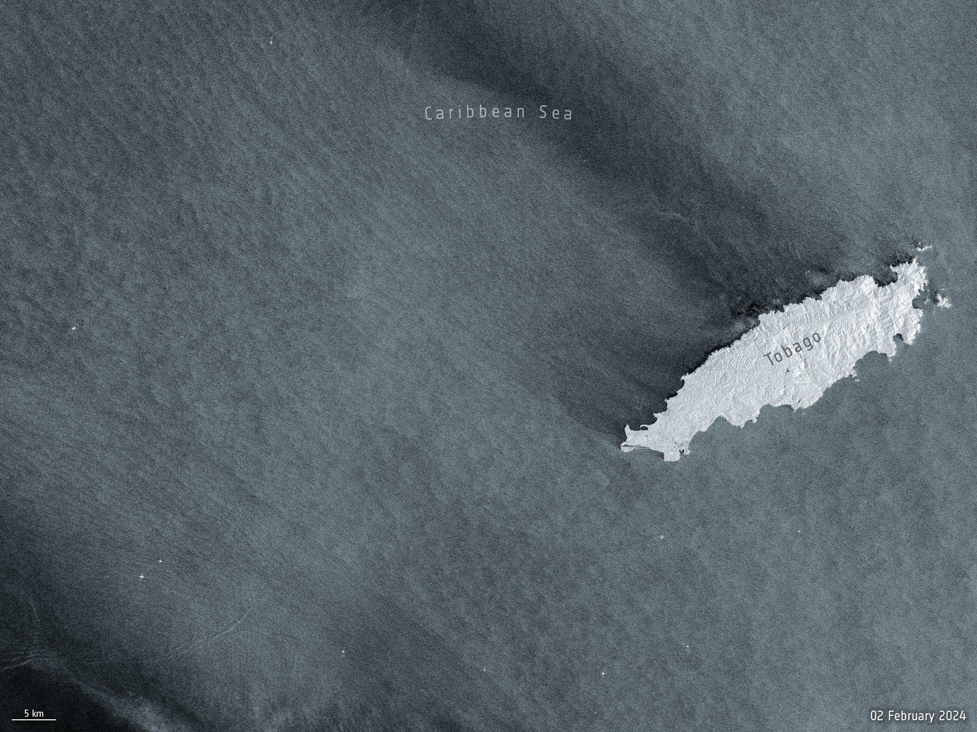 Image:
Before and after satellite images from the Copernicus Sentinel-1 mission show the scale of the oil spill that occurred off the shores of Trinidad and Tobago’s coastline earlier this week.
Image:
Before and after satellite images from the Copernicus Sentinel-1 mission show the scale of the oil spill that occurred off the shores of Trinidad and Tobago’s coastline earlier this week.
Otevírací doba [Knihovna geografie, byTopic]
16.2.2024 11:40 Katedra aplikované geoinformatiky a kartografie Přf UK Knihovny geografie v letním semestru 2024odborný rada – právník
16.2.2024 10:58 ČÚZK - předpisy a opatření Katastrální úřad pro hlavní město Prahu zveřejnil novou aktualitu: Ředitelka úřadu vyhlašuje výběrové řízení na pozici:odborný rada – právník
odborný rada – právník
16.2.2024 10:58 ČÚZK /Urady/Katastralni-urady/Katastralni-urady/Katastralni-urad-pro-hlavni-mesto-Prahu/O-uradu/Aktuality/odborny-rada-–-pravnik-(1)odborný rada – právník
16.2.2024 10:57 ČÚZK /Urady/Katastralni-urady/Katastralni-urady/Katastralni-urad-pro-hlavni-mesto-Prahu/Uredni-deska/Oznameni-a-jina-uredni-sdeleni/Volna-mista/odborny-rada-–-pravnik-(1)odborný rada – právník
16.2.2024 10:57 ČÚZK - předpisy a opatření Katastrální úřad pro hlavní město Prahuvypisuje výběrové řízení na místo
odborný rada – právník
odborný rada – právník
16.2.2024 10:57 ČÚZK - volná místa Katastrální úřad pro hlavní město Prahu vypisuje výběrové řízení na místo odborný rada – právníkTři Fusiony za cenu dvou
16.2.2024 10:27 Adeon
Autodesk ohlásil jarní akci pro nové licence aplikace Fusion 360. V rámci akce lze pořídit 3 nové licence za cenu […]
The post Tři Fusiony za cenu dvou appeared first on Adeon CZ.
Earth from Space: Côte d'Ivoire
16.2.2024 10:00 ESA Observing the Earth Image:
The Copernicus Sentinel-2 mission takes us over Côte d'Ivoire in western Africa.
Image:
The Copernicus Sentinel-2 mission takes us over Côte d'Ivoire in western Africa.
Nové číslo GaKO
16.2.2024 9:03
ÚGKK SR
Nové číslo časopisu Geodetického a Kartografického Obzoru 02/2024
The “Use case 2.06 – Collision check & mechanical integration of medium voltage distribution systems in a building” Activity Proposal is now out for review by the Standards Committee.
16.2.2024 3:07 buildingSMART.orgThe “Use case 2.06 – Collision check & mechanical integration of medium voltage distribution systems in a building” Activity Proposal is now out for review by the Standards Committee. The…
The post The “Use case 2.06 – Collision check & mechanical integration of medium voltage distribution systems in a building” Activity Proposal is now out for review by the Standards Committee. appeared first on buildingSMART International.
The “Use case 2.06 – Collision check & mechanical integration of medium voltage distribution systems in a building” Activity Proposal is now out for review by the Standards Committee.
16.2.2024 2:44 buildingSMART.orgThe “Use case 2.06 – Collision check & mechanical integration of medium voltage distribution systems in a building” Activity Proposal is now out for review by the Standards Committee. The…
The post The “Use case 2.06 – Collision check & mechanical integration of medium voltage distribution systems in a building” Activity Proposal is now out for review by the Standards Committee. appeared first on buildingSMART International.
Test title
15.2.2024 16:09 buildingSMART.orgContent here
The post Test title appeared first on buildingSMART International.
What does a warming Arctic mean for the future?
15.2.2024 16:00 ESA Observing the Earth Video:
00:12:27
Video:
00:12:27
The Arctic is experiencing disproportionately higher temperature increases compared to the rest of the planet, triggering a series of cascading effects. This rapid warming has profound implications for global climate patterns, human populations and wildlife.
The Copernicus Imaging Microwave Radiometer mission (CIMR) will provide measurements to decision makers with evidence of change and impact in the polar regions – with a focus on the Arctic.
The mission has the largest radiometer developed by ESA and will provide high-resolution measurements related to sea ice, the ocean, snow and ice-sheet surfaces. This will be crucial in understanding the evolution of the climate in the polar region.
CIMR is one of six Copernicus Sentinel Expansion missions that ESA is developing on behalf of the EU. The missions will expand the current capabilities of the Copernicus Space Component – the world’s biggest supplier of Earth observation data.
This video features interviews with Craig Donlon, CIMR Mission Scientist, Rolv Midthassel, CIMR Payload Manager, Claudio Galeazzi, CIMR Project Manager, Mariel Triggianese, CIMR Satellite Engineering and AIV Manager, and Marcello Sallusti, CIMR System Performance and Operations Manager.
In the meantime Craig has changed his role but will retain his position as Mission Scientist.
Access all "Unpacking Sentinels" videos.
What does a warming Arctic mean for the future?
15.2.2024 16:00 ESA Observing the Earth
Video:
00:12:27
The Arctic is experiencing disproportionately higher temperature increases compared to the rest of the planet, triggering a series of cascading effects. This rapid warming has profound implications for global climate patterns, human populations and wildlife.
The Copernicus Imaging Microwave Radiometer mission (CIMR) will provide measurements to decision makers with evidence of change and impact in the polar regions – with a focus on the Arctic.
The mission has the largest radiometer developed by ESA and will provide high-resolution measurements related to sea ice, the ocean, snow and ice-sheet surfaces. This will be crucial in understanding the evolution of the climate in the polar region.
CIMR is one of six Copernicus Sentinel Expansion missions that ESA is developing on behalf of the EU. The missions will expand the current capabilities of the Copernicus Space Component – the world’s biggest supplier of Earth observation data.
This video features interviews with Craig Donlon, CIMR Mission Scientist, Rolv Midthassel, CIMR Payload Manager, Claudio Galeazzi, CIMR Project Manager, Mariel Triggianese, CIMR Satellite Engineering and AIV Manager, and Marcello Sallusti, CIMR System Performance and Operations Manager.
In the meantime Craig has changed his role but will retain his position as Mission Scientist.
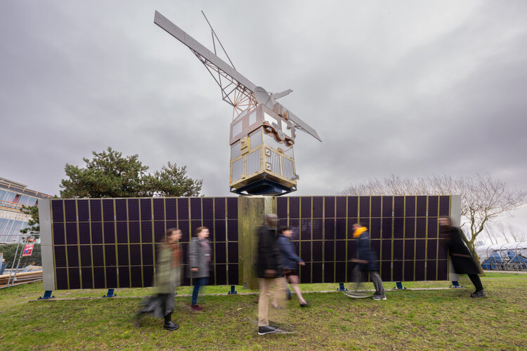 Image:
Saying goodbye to ERS-2
Image:
Saying goodbye to ERS-2
GaKO 2/2024
15.2.2024 14:30 GaKO GaKO 2/2024 KYSEĽ, P.: Obnova vektorovej katastrálnej mapy číselnej s lokálnym posunomTajemná Indonésie [Knihovna geografie, byTopic]
15.2.2024 10:30 Katedra aplikované geoinformatiky a kartografie Přf UK Svět, o kterém jste si mysleli, že už neexistuje!Zveřejnění obsahu informací poskytnutých na žádost dle zákona č. 106/1999 Sb. za rok 20
15.2.2024 9:33 ČÚZK - předpisy a opatření Zeměměřický a katastrální inspektorát v Brnězveřejňuje obsah informace poskytnutých na žádost dle zákona č. 106/1999 Sb. za rok
2024
Zveřejnění obsahu informací poskytnutých na žádost dle zákona č. 106/1999 Sb. za rok 20
15.2.2024 9:33 ČÚZK /Urady/Zememericke-a-katastralni-inspektoraty/Zememericke-a-katastralni-inspektoraty/Zememericky-a-katastralni-inspektorat-v-Brne/Casto-hledane-informace/Poskytovani-informaci-106-1999-Sb/Zverejneni-obsahu-informaci-poskytnutych-na-za-(1)/Zverejneni-obsahu-informaci-poskytnutych-na-za-(8)ERS-2 reentry – how and why is it happening?
15.2.2024 9:30 ESA Observing the Earth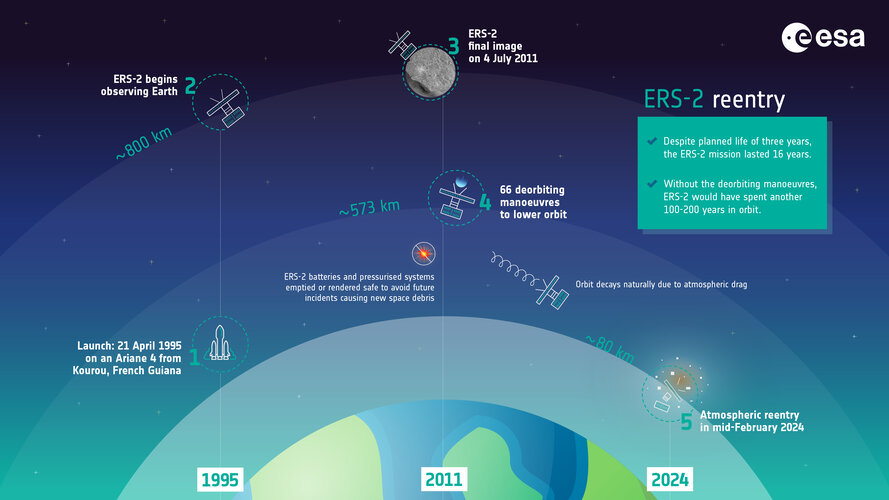 Image:
ERS-2 reentry – how and why is it happening?
Image:
ERS-2 reentry – how and why is it happening?
Mapové služby v https.
15.2.2024 9:10 Jihočeský krajMapové služby na Geoportálu jsou nově přístupné pouze přes protokol HTTPS. Protokol HTTP již není dostupný.
Erasmus [Knihovna geografie, byTopic]
15.2.2024 7:55 Katedra aplikované geoinformatiky a kartografie Přf UK Knihovnu geografie navštívili studenti Erasmu.Strengthening EU Resilience: The Horizon Europe GEXTRECS project and secure SATCOM
14.2.2024 17:13 European GNSS Agency
Protecting citizens and freedoms stands as a cornerstone of the European Union's strategic agenda for 2019-2024, with a priority to increase the EU's resilience against both natural and man-made disasters. At the heart of this effort lies the need for secure satellite communications (SATCOM), essential for implementing a common security policy and safeguarding EU autonomy and independence.
Secure SATCOM serves as a vital communication tool for covering large geographical areas and operating in remote or isolated sites. It also functions as an instrumental backup communication means when terrestrial networks face compromise or unreliability. Recognizing this, the European Union Governmental Satellite Communications (EU GOVSATCOM) Programme aims to furnish secure, guaranteed and cost-effective SATCOM services to eligible EU governmental users.
In this context, the Horizon Europe project GEXTRECS emerges aimed at defining and demonstrating an End-to-End GOVSATCOM Service supporting Extreme Events Crisis Management. GEXTRECS Kick Off Meeting took place at EUSPA Headquarters on February 8, 2024, with attendance of representatives of all project partners.
Over the course of 24 months, GEXTRECS endeavours to develop a solution that meets user needs and requirements for secure SATCOM, while also exploring synergies with other EU Space Programme components, notably Galileo and Copernicus, in emergency management. Two demonstrations are planned: one addressing a cross-border emergency scenario and another focused on maritime emergencies.
The project leverages the expertise of skilled user professionals in both land and maritime scenarios, engaging worldwide stakeholders from private and governmental entities involved in massive emergencies to prepare the solution for operational use. Among others, the consortium aims to create training materials and solicit end-user feedback through dedicated Key Performance Indicators assessed during the demonstrations.
Demonstrations will be coordinated from the On-Site Operations Coordination Centre hosted by the Training Base Weeze (TBW) located in Germany. From there, demonstrations of land and maritime use cases will be managed, coordinating with technical teams deployed onboard a vessel in Spain and on land near TBW.
The innovative GEXTRECS solution integrates several key components:
- A smart and continuous Dynamic Planner, which will enable dynamic SATCOM resources allocation in the most optimal manner, making use of advance heuristics;
- A Network Balancer, which will enable the required interoperability ensuring that secure communications are preserved when using different communications networks;
- Copernicus based products and services (e.g. Emergency Management Service (CEMS),..)
- Galileo services and differentiators, tailored to the selected use cases
The GEXTRECS consortium brings together expertise from four EU countries: Germany, Italy, Poland, and Spain. Partners possess extensive experience in addressing emergencies stemming from natural hazards such as fires, floods, and earthquakes, as well as challenges related to geographical situations.
Through collaborative efforts like GEXTRECS, the EU aims to enhance its resilience and responsiveness to crises, ensuring the safety and security of its citizens while reinforcing its position as a leader in satellite communication technology and emergency management.
Media note: This feature can be republished without charge provided the European Union Agency for the Space Programme (EUSPA) is acknowledged as the source at the top or the bottom of the story. You must request permission before you use any of the photographs on the site. If you republish, we would be grateful if you could link back to the EUSPA website (http://www.euspa.europa.eu).
Informace o výsledcích kontrol dle § 26 zákona č. 255/2012 Sb. za rok 2023
14.2.2024 14:15 ČÚZK - předpisy a opatření Český úřad zeměměřický a katastrálnívydává informace o výsledcích kontrol dle § 26 zákona č. 255/2012 Sb. za rok
2023
Obnova katastrálního operátu novým mapováním v k. ú. Svor
14.2.2024 9:21 ČÚZK /Urady/Katastralni-urady/Katastralni-urady/Katastralni-urad-pro-Liberecky-kraj/Katastralni-pracoviste/KP-Ceska-Lipa/O-uradu/Aktuality/Obnova-katastralniho-operatu-novym-mapovanim-v-k-uObnova katastrálního operátu novým mapováním v k. ú. Svor
14.2.2024 9:21 ČÚZK - předpisy a opatření Katastrální úřad pro Liberecký kraj - Katastrální pracoviště Česká Lípa zveřejnil novou aktualitu:Obnova katastrálního operátu novým mapováním v k. ú. Svor
14.2.2024 9:21 ČÚZK - předpisy a opatření Katastrální úřad pro Liberecký kraj - Katastrální pracoviště Česká Lípa zveřejnil novou aktualitu: Katastrální úřad pro Liberecký kraj, Katastrální pracoviště Česká Lípa oznamuje, že v katastrálním území Svor obce Svor bude od přibližně září 2024 zahájena obnova katastrálního operátu novým mapováním. Podrobnosti viz úřední deska.odborný referent/vrchní referent – revize katastrálního operátu
13.2.2024 20:34 ČÚZK - předpisy a opatření Katastrální úřad pro hlavní město Prahu zveřejnil novou aktualitu: Ředitelka úřadu vyhlašuje výběrové řízení na pozici:odborný referent/vrchní referent – revize katastrálního operátu
odborný referent/vrchní referent – revize katastrálního operátu
13.2.2024 20:34 ČÚZK /Urady/Katastralni-urady/Katastralni-urady/Katastralni-urad-pro-hlavni-mesto-Prahu/O-uradu/Aktuality/odborny-referent-vrchni-referent-–-revize-katastraodborný referent/vrchní referent – revize katastrálního operátu
13.2.2024 20:32 ČÚZK - předpisy a opatření Katastrální úřad pro hlavní město Prahuvypisuje výběrové řízení na místo
odborný referent/vrchní referent – revize katastrálního operátu
odborný referent/vrchní referent – revize katastrálního operátu
13.2.2024 20:32 ČÚZK - volná místa Katastrální úřad pro hlavní město Prahu vypisuje výběrové řízení na místo odborný referent/vrchní referent – revize katastrálního operátuodborný referent/vrchní referent – revize katastrálního operátu
13.2.2024 20:32 ČÚZK /Urady/Katastralni-urady/Katastralni-urady/Katastralni-urad-pro-hlavni-mesto-Prahu/Uredni-deska/Oznameni-a-jina-uredni-sdeleni/Volna-mista/odborny-referent-vrchni-referent-–-revize-katastraEnhancing critical infrastructure resilience: Galileo Timing Receivers standardization
13.2.2024 16:44 European GNSS Agency
Accurate and secure timing information is essential for critical infrastructure in strategic networks such as the energy distribution grids, the telecom, or financial ones. These sectors, and all timing users, will benefit from the Galileo Timing Service and from the implementation of Standards in timing receivers.
On February 2nd, the Workshop on standardisation of Galileo Timing Receivers, jointly organized by EUSPA and the European Commission, with the support of the Joint Research Centre (JRC), convened a large number of stakeholders from various sectors crucial to critical infrastructure, including receiver manufacturers, telecom operators, timing laboratories, research institutions and BIPM. At the centre of this workshop was the presentation of the 1st Galileo Timing Receiver Standard, developed within CEN/CENELEC under the initiative of the European Commission. The Standard will play a pivotal role towards ensuring higher levels of timing accuracy and reliability to end users.
Key outcomes included reaffirming the necessity of timing receiver standards, previously identified by projects developed under Horizon 2020 and Fundamental Elements programmes. The Workshop was also the occasion to review the comprehensive set of requirements and needs for timing and synchronization, overseen by EUSPA as part of the User Consultation Platform process – and published through the Report on Time & Synchronisation User Needs and Requirements. Notably none of the existing requirements were challenged and they remained as per the current version.
The active participation during the Q&A session, allowing attendees to delve deeper into the standard, particularly beneficial for those unfamiliar with the CEN/CENELEC process, demonstrated the strong interest in the workshop.
In summary, the workshop provided the opportunity to present and discuss the Standard for Galileo Timing Receivers, confirms its relevance for the community and validates the existing set of timing and synchronisation user needs and requirements.
For additional insights, you can find the presentations delivered here.
Media note: This feature can be republished without charge provided the European Union Agency for the Space Programme (EUSPA) is acknowledged as the source at the top or the bottom of the story. You must request permission before you use any of the photographs on the site. If you republish, we would be grateful if you could link back to the EUSPA website (http://www.euspa.europa.eu).
Air pollution fluctuations over the Po Valley
13.2.2024 15:49 ESA Observing the Earth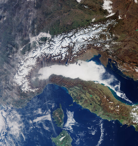
The Po Valley, nestled in northern Italy, is renowned for its picturesque landscapes and rich agricultural history. However, the region is also grappling with a persistent environmental challenge: air pollution. The unique geographical and meteorological conditions of the Po Valley contribute to fluctuations in air quality – impacting the health of its residents.
Přerušení provozu DP a WSDP v pátek 16.2.2024 od 20:00 do cca 21:30.
13.2.2024 15:38 ČÚZK /Aplikace-DP-do-KN/Aplikace-DP-do-KN/Archiv-DP/408404Přerušení provozu DP a WSDP v pátek 16.2.2024 od 20:00 do cca 21:30.
13.2.2024 15:38 Dálkový přístup k údajům KN ČR Vážení uživatelé,oznamujeme, že v pátek 16.2.2024 od 20:00 bude z provozních důvodů zcela přerušen provoz Dálkového přístupu i Webových služeb dálkového přístupu. Obnovení provozu předpokládáme v cca 21:30 hodin. U této verze nedochází ke změnám webových služeb.
Za komplikace tímto způsobené se omlouváme a děkujeme za pochopení.
Přerušení provozu DP a WSDP v pátek 16.2.2024 od 20:00 do cca 21:30.
13.2.2024 15:38 ČÚZK - předpisy a opatření Vážení uživatelé,oznamujeme, že v pátek 16.2.2024 od 20:00 bude z provozních důvodů zcela přerušen provoz Dálkového přístupu i Webových služeb dálkového přístupu. Obnovení provozu předpokládáme v cca 21:30 hodin. U této verze nedochází ke změnám webových služeb.
Za komplikace tímto způsobené se omlouváme a děkujeme za pochopení.
Vrchní referent/rada – oddělení dokumentace KN
13.2.2024 13:13 ČÚZK - předpisy a opatření Katastrální úřad pro Karlovarský kraj Katastrální pracoviště Chebvypisuje výběrové řízení na místo
Vrchní referent/rada – oddělení dokumentace KN
Vrchní referent/rada – oddělení dokumentace KN
13.2.2024 13:13 ČÚZK /Urady/Katastralni-urady/Katastralni-urady/Katastralni-urad-pro-Karlovarsky-kraj/Uredni-deska/Oznameni-a-jina-uredni-sdeleni/Volna-mista/DMS/Vrchni-referent-rada-–-oddeleni-dokumentace-KNVrchní referent/rada – oddělení dokumentace KN
13.2.2024 13:13 ČÚZK - volná místa Katastrální úřad pro Karlovarský kraj Katastrální pracoviště Cheb vypisuje výběrové řízení na místo Vrchní referent/rada – oddělení dokumentace KNVerze 1.6.1.1 na PROD
13.2.2024 10:38 ČÚZK - předpisy a opatření Český úřad zeměměřický a katastrální informuje, že byla dokončena instalace nové verze 1.6.1.1 informačního systému na produkční prostředí IS DMVS, prostředí je opět dostupné. Přehledný seznam změn této verze je popsán v dokumentu Přehled změn IS DMVS ve verzi 1.6Krátka správa č. 9/2024
13.2.2024 10:07 Komora geodetů a kartografů SRThe post Krátka správa č. 9/2024 appeared first on Komora geodetov a kartografov.
Krátka správa č. 8/2024
13.2.2024 9:55 Komora geodetů a kartografů SRThe post Krátka správa č. 8/2024 appeared first on Komora geodetov a kartografov.
Krátka správa č. 7/2024
13.2.2024 9:53 Komora geodetů a kartografů SRThe post Krátka správa č. 7/2024 appeared first on Komora geodetov a kartografov.
Odborný referent – poskytování informací KN
13.2.2024 9:19 ČÚZK - předpisy a opatření Katastrální úřad pro Moravskoslezský kraj Katastrální pracoviště Třinecvypisuje výběrové řízení na místo
Odborný referent – poskytování informací KN
Odborný referent – poskytování informací KN
13.2.2024 9:19 ČÚZK - volná místa Katastrální úřad pro Moravskoslezský kraj Katastrální pracoviště Třinec vypisuje výběrové řízení na místo Odborný referent – poskytování informací KNOdborný referent – poskytování informací KN
13.2.2024 9:19 ČÚZK /Urady/Katastralni-urady/Katastralni-urady/Katastralni-urad-pro-Moravskoslezsky-kraj/Uredni-deska/Oznameni-a-jina-uredni-sdeleni/Volna-mista/DMS/Odborny-referent-–-poskytovani-informaci-KNVizualizace investičních projektů Magistrátu města Zlína pomocí ArcGIS Dashboard
13.2.2024 8:52 blog ARCDATA Webová aplikace umožňuje interaktivně procházet a přehledně vizualizovat městskou databázi investičních projektů a záměrů.Nová mapová aplikace - Uzavírky silnic v Jihočeském kraji v roce 2024
12.2.2024 13:40 Jihočeský krajByla vytvořena mapová aplikace Uzavírky silnic v Jihočeském kraji v roce 2024, zobrazující dopravní omezení včetně objízdných tras na silnicích v Jihočeském kraji.
20240212_Investiční referent oddělení hospodářské správy – vrchní referent / rada
12.2.2024 10:47 ČÚZK /Urady/Katastralni-urady/Katastralni-urady/Katastralni-urad-pro-Stredocesky-kraj/O-uradu/Aktuality/20240212_Investicni-referent-oddeleni-hospodarske-20240212_Investiční referent oddělení hospodářské správy – vrchní referent / rada
12.2.2024 10:47 ČÚZK - předpisy a opatření Katastrální úřad pro Středočeský kraj Vyhlášení výběrového řízení: Investiční referent oddělení hospodářské správy – vrchní referent / rada V části "Úřední deska", v sekci "Oznámení a jiná úřední sdělení" bylo vystaveno "Oznámení o vyhlášení výběrového řízení na obsazení služebního místa Investiční referent oddělení hospodářské správy – vrchní referent / rada"20240212_Odborný referent oddělení právních vztahů k nemovitostem
12.2.2024 10:18 ČÚZK - předpisy a opatření Katastrální úřad pro Středočeský kraj - Katastrální pracoviště Příbram Vyhlášení výběrového řízení: Odborný referent oddělení právních vztahů k nemovitostem Katastrálního pracoviště Příbram V části "Úřední deska", v sekci "Oznámení a jiná úřední sdělení" bylo vystaveno "Oznámení o vyhlášení výběrového řízení na obsazení služebního místa Odborný referent oddělení právních vztahů k nemovitostem Katastrálního pracoviště Příbram"20240212_Odborný referent oddělení právních vztahů k nemovitostem
12.2.2024 10:18 ČÚZK /Urady/Katastralni-urady/Katastralni-urady/Katastralni-urad-pro-Stredocesky-kraj/Katastralni-pracoviste/KP-Pribram/O-uradu/Aktuality/20240212_Odborny-referent-oddeleni-pravnich-vztahu30 let české krajiny - 30 let změn [Katedra aplikované geoinformatiky a kartografie, byTopic]
12.2.2024 9:10 Katedra aplikované geoinformatiky a kartografie Přf UK Krajina naší země se za dobu její samostatnosti výrazně změnila. Kde se kdysi pásly ovce, tam dnes najdeme pole. Kde kdysi bývala pole, tam dnes nacházíme lesy. Kde kdysi bývaly lesy, tam dnes třeba i bydlíme. Jak se změnila naše krajina od pádu komunismu? Jak způsoby, jakými ji využíváme, souvisí s vývojem naší společnosti a se změnami s ní spjatými? K jaké podobě vlastně směřuje česká krajina? Nejen tyto otázky se snažili zodpovědět Petra Grešlová z CENIA (CENIA – Czech Environmental Information Agency), Josef Laštovička a Přemysl Štych z Katedry aplikované geoinformatiky a kartografie z Přírodovědecké fakulty Univerzity Karlovy.20230212-VŘ KP
12.2.2024 9:01 ČÚZK - aktuality v resortu Oznámení o vyhlášení výběrových řízení na obsazení služebních míst ředitele/ ředitelky Katastrálního pracoviště Rychnov nad Kněžnou, Katastrálního pracoviště Náchod, Katastrálního pracoviště Vsetín a Katastrálního pracoviště Ústí nad Labem.20230212-VŘ KP
12.2.2024 9:01 ČÚZK - aktuality v resortu Oznámení o vyhlášení výběrového řízení na obsazení služebního místa ředitele/ ředitelky Katastrálního pracoviště Rychnov nad Kněžnou, Katastrálního pracoviště Náchod, Katastrálního pracoviště Vsetín a Katastrálního pracoviště Ústí nad Labem.20230212-VŘ KP
12.2.2024 9:01 ČÚZK - předpisy a opatření Český úřad zeměměřický a katastrální zveřejnil novou aktualitu: Oznámení o vyhlášení výběrových řízení na obsazení služebních míst ředitele/ ředitelky Katastrálního pracoviště Rychnov nad Kněžnou, Katastrálního pracoviště Náchod, Katastrálního pracoviště Vsetín a Katastrálního pracoviště Ústí nad Labem.20230212-VŘ KP
12.2.2024 9:01 ČÚZK - aktuality v resortu Oznámení o vyhlášení výběrového řízení na obsazení služebního místa ředitele/ ředitelky Katastrálního pracoviště Rychnov nad Kněžnou, Katastrálního pracoviště Náchod, Katastrálního pracoviště Vsetín a Katastrálního pracoviště Ústí nad Labem.20230212-VŘ KP
12.2.2024 9:01 ČÚZK - předpisy a opatření Český úřad zeměměřický a katastrálnízveřejnil novou aktualitu: Oznámení o vyhlášení výběrových řízení na obsazení služebních míst ředitele/ ředitelky Katastrálního pracoviště Rychnov nad Kněžnou, Katastrálního pracoviště Náchod, Katastrálního pracoviště Vsetín a Katastrálního pracoviště Ústí nad Labem.
20230212-VŘ KP
12.2.2024 9:01 ČÚZK - předpisy a opatření Český úřad zeměměřický a katastrální zveřejnil novou aktualitu: Oznámení o vyhlášení výběrového řízení na obsazení služebního místa ředitele/ ředitelky Katastrálního pracoviště Rychnov nad Kněžnou, Katastrálního pracoviště Náchod, Katastrálního pracoviště Vsetín a Katastrálního pracoviště Ústí nad Labem.20230212-VŘ KP
12.2.2024 9:01 ČÚZK - aktuality v resortu Oznámení o vyhlášení výběrových řízení na obsazení služebních míst ředitele/ ředitelky Katastrálního pracoviště Rychnov nad Kněžnou, Katastrálního pracoviště Náchod, Katastrálního pracoviště Vsetín a Katastrálního pracoviště Ústí nad Labem.20240212_Výpadek elektrického proudu
12.2.2024 8:56 ČÚZK - předpisy a opatření Katastrální úřad pro Středočeský kraj - Katastrální pracoviště Mělníkzveřejnil novou aktualitu: Výpadek elektrického proudu Z důvodu výpadku dodávky elektrického proudu, jsou dnes do cca 14:30 hod. omezeny služby poskytované naším pracovištěm. Za komplikace se omlouváme.
20240212_Výpadek elektrického proudu
12.2.2024 8:56 ČÚZK /Urady/Katastralni-urady/Katastralni-urady/Katastralni-urad-pro-Stredocesky-kraj/Katastralni-pracoviste/KP-Melnik/O-uradu/Aktuality/20240212_Vypadek-elektrickeho-prouduOznámení o vyhlášení VŘ na služební místo rada - odborný rada
12.2.2024 6:35 ČÚZK - předpisy a opatření Zeměměřický a katastrální inspektorát v Praze zveřejnil novou aktualitu: Zeměměřický a katastrální inspektorát v Praze vyhlašuje výběrová řízení na služební místa Rada/Odborný rada inspektor (obor služby 55).Rada/odborný rada - inspektor ZKI v Praze (odbor služby 55.)
12.2.2024 6:33 ČÚZK - předpisy a opatření Zeměměřický a katastrální inspektorát v Prazevypisuje výběrové řízení na místo
Rada/odborný rada - inspektor ZKI v Praze (odbor služby 55.)
TurboCAD Deluxe + TurboPDF v akční ceně
9.2.2024 16:05 ŠPINAR - softwareVážení zákazníci,
dovolujeme si Vám nabídnout programy TurboCAD Deluxe 28 + TurboPDF, které spojují CAD nástroje pro kreslení ve 2D / 3D prostoru včetně fotorealistických výstupů s editorem a převodníkem PDF dokumentů v akční ceně do 17. 02. 2024.
The post TurboCAD Deluxe + TurboPDF v akční ceně appeared first on ŠPINAR – software.
TurboCAD Deluxe + TurboPDF v akční ceně
9.2.2024 16:05 ŠPINAR - softwareVážení zákazníci,
dovolujeme si Vám nabídnout programy TurboCAD Deluxe 28 + TurboPDF, které spojují CAD nástroje pro kreslení ve 2D / 3D prostoru včetně fotorealistických výstupů s editorem a převodníkem PDF dokumentů v akční ceně do 17. 02. 2024.
Rozpočet úřadu za rok 2024
9.2.2024 15:18 ČÚZK - předpisy a opatření Zeměměřický úřadvystavuje rozpočet úřadu za rok
2024
Rozpočet úřadu za rok 2024
9.2.2024 15:18 ČÚZK - předpisy a opatření Zeměměřický úřadvystavuje rozpočet úřadu za rok
2024
Rozpočet úřadu za rok 2024
9.2.2024 15:18 ČÚZK /Urady/Zememericky-urad/Rozpocty/Rozpocet-uradu-za-rok-2024Rozpočet úřadu za rok 2024
9.2.2024 15:18 ČÚZK /Urady/Zememericky-urad/Rozpocty/Rozpocet-uradu-za-rok-2024Rozpočet úřadu za rok 2024
9.2.2024 15:18 Zeměměřický úřad Zeměměřický úřadvystavuje rozpočet úřadu za rok
2024
Rozpočet úřadu za rok 2024
9.2.2024 15:18 Zeměměřický úřad Zeměměřický úřadvystavuje rozpočet úřadu za rok
2024
112 and Galileo: Answering the call and saving lives
9.2.2024 14:55 European GNSS Agency
With the European 112-emergency number, help is never more than a phone call away. The service, which is available free of charge from fixed and mobile phones everywhere in the EU, connects a caller to a Public Safety Answering Point (PSAP). A PSAP is a call centre where calls for first responders, including police, ambulance and fire brigade, are received and handled.
While 112 has been answering the call – and saving lives – for over 30 years, thanks in part to EU Space, it’s also continually evolving to offer even better services.
The EU Space Programme was conceived to benefit and protect EU citizens, and Galileo’s successful integration into the 112-emergency number does exactly that.
As Europe celebrates 112 Day, let’s look at how the EU Space Programme is helping to enhance these lifesaving digits.
Galileo signals for more accurate positioning
Before we started to use GNSS for locating callers making an emergency call from their smartphones, when an emergency call was placed via a mobile phone, the caller’s location was established based on the coverage area of a cellular network tower. Unfortunately, the accuracy of that location information could vary anywhere from two to 10 kilometres. That’s a pretty big gap in which an emergency responder would need to find you!
But today, GNSS, including Galileo, which helps fill this accuracy gap.
In fact, the EU now requires that all smartphones placed in the European single market be compatible and interoperable with at least Galileo. The result is E112, a location-enhanced version of the 112-emergency service.
When a mobile phone is GNSS-enabled, including Galileo one, it can provide location information with an accuracy of down to just a few metres. This level of accuracy can have a major impact in terms of response times – and in emergency situations, every second counts.
Advanced Mobile Location (AML) uses GNSS information from the caller’s smartphone to accurately locate them. When a caller dials 112 from their smartphone, AML uses the phone’s integrated functionalities, deriving data from Galileo (and Wi-Fi) to accurately pinpoint the caller’s location. This information is then transmitted to a dedicated endpoint, usually a PSAP, which makes the caller’s location available to emergency responders, ensuring that help gets to where it needs to be even faster.
Putting the power of Galileo into smartphones and emergency control rooms across Europe translates into even more lives being saved.
Currently, more than 3 billion Galileo-enabled smartphones are in use worldwide. You can see if yours is one of them by visiting www.useGalileo.eu.
eCall to the rescue
While 112 has proven to be a lifesaving service, it only works if you call it. However, in a motor vehicle accident, a victim might not be able to reach their mobile phone or be physically capable of calling 112.
In situations like these, there’s eCall.
The eCall service is automatically activated as soon as in-vehicle sensors detect a serious crash. Once activated, the system dials the 112-emergency number and establishes a telephone link to the appropriate emergency call centre.
Leveraging EGNSS (Galileo and EGNOS), the system sends the accurate position of the crashed vehicle and the direction of travel to the emergency services, enabling responders to get to the accident site faster.
An eCall can also be triggered manually by pushing a button in the car, for example by a witness to a serious accident.
According to the European Commission, in some cases eCall can cut emergency response times in half, reducing the number of fatalities by 4% and the number of severe injuries by 6 – 10%. More so, thanks to improved accident management, it has the potential to help reduce congestion costs caused by traffic accidents.
All new car models sold in the EU are required to come with the Galileo-enabled 112-based eCall system already installed.
“eCall is a true success story for Europe, one that leverages EU Space and specifically Galileo’s precise positioning to save lives – which is certainly something worth celebrating,” concludes da Costa.
Media note: This feature can be republished without charge provided the European Union Agency for the Space Programme (EUSPA) is acknowledged as the source at the top or the bottom of the story. You must request permission before you use any of the photographs on the site. If you republish, we would be grateful if you could link back to the EUSPA website (http://www.euspa.europa.eu).
20240209 - VŘ Správce RÚIAN
9.2.2024 14:41 ČÚZK - předpisy a opatření Český úřad zeměměřický a katastrální zveřejnil novou aktualitu: Oznámení o vyhlášení výběrového řízení na obsazení služebního místa odborný rada - Správce/správkyně RÚIAN.20240209 - VŘ Správce RÚIAN
9.2.2024 14:41 ČÚZK - aktuality v resortu Oznámení o vyhlášení výběrového řízení na obsazení služebního místa odborný rada - Správce/správkyně RÚIAN.rada/odborný rada - rozhodování o povolení vkladu v oddělení právních vztahů k nemovitostem na Katas
9.2.2024 12:53 ČÚZK /Urady/Katastralni-urady/Katastralni-urady/Katastralni-urad-pro-Jihocesky-kraj/Uredni-deska/Oznameni-a-jina-uredni-sdeleni/Volna-mista/DMS/rada-odborny-rada-rozhodovani-o-povoleni-vklad-(1)rada/odborný rada - rozhodování o povolení vkladu v oddělení právních vztahů k nemovitostem na Katas
9.2.2024 12:53 ČÚZK - volná místa Katastrální úřad pro Jihočeský kraj Katastrální pracoviště Český Krumlov vypisuje výběrové řízení na místo rada/odborný rada - rozhodování o povolení vkladu v oddělení právních vztahů k nemovitostem na Katasrada/odborný rada - rozhodování o povolení vkladu v oddělení právních vztahů k nemovitostem na Katas
9.2.2024 12:53 ČÚZK - předpisy a opatření Katastrální úřad pro Jihočeský kraj Katastrální pracoviště Český Krumlovvypisuje výběrové řízení na místo
rada/odborný rada - rozhodování o povolení vkladu v oddělení právních vztahů k nemovitostem na Katastrálním pracovišti Český Krumlov (ID SM 30000150/30003774)
20240209 - volné místo - Účetní v ekonom. odd. kanceláře ředitele katastrálního úřadu na KÚ pro UK
9.2.2024 11:55 ČÚZK /Urady/Katastralni-urady/Katastralni-urady/Katastralni-urad-pro-Ustecky-kraj/O-uradu/Aktuality/20240209-volne-misto-Ucetni-v-ekonom-odd-kancelare20240209 - volné místo - Účetní v ekonom. odd. kanceláře ředitele katastrálního úřadu na KÚ pro UK
9.2.2024 11:55 ČÚZK - předpisy a opatření Český úřad zeměměřický a katastrální zveřejnil novou aktualitu: Nabídka volného místa - Účetní v ekonomickém oddělení kanceláře ředitele katastrálního úřadu na Katastrálním úřadu pro Ústecký krajÚčetní v ekonomickém oddělení kanceláře ředitele katastrálního úřadu na Katastrálním úřadu pro Ústec
9.2.2024 11:43 ČÚZK - předpisy a opatření Katastrální úřad pro Ústecký kraj kancelář ředitelevypisuje výběrové řízení na místo
Účetní v ekonomickém oddělení kanceláře ředitele katastrálního úřadu na Katastrálním úřadu pro Ústecký kraj
Účetní v ekonomickém oddělení kanceláře ředitele katastrálního úřadu na Katastrálním úřadu pro Ústec
9.2.2024 11:43 ČÚZK /Urady/Katastralni-urady/Katastralni-urady/Katastralni-urad-pro-Ustecky-kraj/Volna-mista/DMS/Ucetni-v-ekonomickem-oddeleni-kancelare-reditele-kÚčetní v ekonomickém oddělení kanceláře ředitele katastrálního úřadu na Katastrálním úřadu pro Ústec
9.2.2024 11:43 ČÚZK - volná místa Katastrální úřad pro Ústecký kraj kancelář ředitele vypisuje výběrové řízení na místo Účetní v ekonomickém oddělení kanceláře ředitele katastrálního úřadu na Katastrálním úřadu pro ÚstecSchválení oprav JVF DTM 1.4.3
9.2.2024 10:31 ČÚZK - předpisy a opatření Český úřad zeměměřický a katastrální informuje, že dne 8. února 2024 byly Koordinační radou správců DMVS a DTM schváleny drobné formální opravy JVF DTM verze 1.4.3. Přehled realizovaných oprav je uveden v dokumentu Přehled dodatečných změn v XSD a popisech JVF 1.4.3 k 17.1.2024Earth from Space: South Atlantic bloom
9.2.2024 10:00 ESA Observing the Earth Image:
This wide view from the Copernicus Sentinel-3 mission captures an algae bloom around the Falkland Islands in the South Atlantic Ocean.
Image:
This wide view from the Copernicus Sentinel-3 mission captures an algae bloom around the Falkland Islands in the South Atlantic Ocean.
Výběrové řízení na KÚ pro Vysočinu
9.2.2024 9:05 ČÚZK /Urady/Katastralni-urady/Katastralni-urady/Katastralni-urad-pro-Vysocinu/O-uradu/Aktuality/Vyberove-rizeni-na-KU-pro-Vysocinu-(1)Výběrové řízení na KÚ pro Vysočinu
9.2.2024 9:05 ČÚZK - předpisy a opatření Katastrální úřad pro Vysočinu zveřejnil novou aktualitu: Oznámení o vyhlášení výběrového řízení na služební místo rada/odborný rada – ředitel/ka Kanceláře ředitele Katastrálního úřadu na Katastrálním úřadu pro Vysočinu.Výběrové řízení na KÚ pro Vysočinu
9.2.2024 9:04 ČÚZK - předpisy a opatření Katastrální úřad pro Vysočinu zveřejnil novou aktualitu: Oznámení o vyhlášení výběrového řízení na služební místo rada/odborný rada – ředitel/ka Technického odboru na Katastrálním úřadu pro Vysočinu.Výběrové řízení na KÚ pro Vysočinu
9.2.2024 9:04 ČÚZK /Urady/Katastralni-urady/Katastralni-urady/Katastralni-urad-pro-Vysocinu/O-uradu/Aktuality/Vyberove-rizeni-na-KU-pro-Vysocinu15th satnav summer school open for registrations
9.2.2024 8:48 ESA Navigation
Are you a young researcher in the field of satellite navigation? Register now for this year’s ESA-JRC International Summer School on Global Navigation Satellite Systems, taking place in Slovenia in July, to learn from top-notch experts and expand your network.
15th satnav summer school open for registrations
9.2.2024 8:48 ESA Navigation
Are you a researcher in the field of satellite navigation? Register now for this year’s ESA-JRC International Summer School on Global Navigation Satellite Systems, taking place in Slovenia in July, to learn from top-notch experts and expand your network.
rada-odborný rada - ředitel-ředitelka Kanceláře ředitele úřadu
9.2.2024 8:17 ČÚZK - volná místa Katastrální úřad pro Vysočinu kancelář ředitele vypisuje výběrové řízení na místo rada-odborný rada - ředitel-ředitelka Kanceláře ředitele úřadurada-odborný rada - ředitel-ředitelka Kanceláře ředitele úřadu
9.2.2024 8:17 ČÚZK - předpisy a opatření Katastrální úřad pro Vysočinu kancelář ředitelevypisuje výběrové řízení na místo
rada-odborný rada - ředitel-ředitelka Kanceláře ředitele úřadu
rada-odborný rada - ředitel-ředitelka Kanceláře ředitele úřadu
9.2.2024 8:17 ČÚZK /Urady/Katastralni-urady/Katastralni-urady/Katastralni-urad-pro-Vysocinu/Uredni-deska/Oznameni-a-jina-uredni-sdeleni/Volna-mista/DMS/rada-odborny-rada-reditel-reditelka-Kancelare-redirada-odborný rada - ředitel-ředitelka Technického odboru
9.2.2024 8:13 ČÚZK /Urady/Katastralni-urady/Katastralni-urady/Katastralni-urad-pro-Vysocinu/Uredni-deska/Oznameni-a-jina-uredni-sdeleni/Volna-mista/DMS/rada-odborny-rada-reditel-reditelka-Technickeho-odrada-odborný rada - ředitel-ředitelka Technického odboru
9.2.2024 8:13 ČÚZK - volná místa Katastrální úřad pro Vysočinu technický odbor vypisuje výběrové řízení na místo rada-odborný rada - ředitel-ředitelka Technického odborurada-odborný rada - ředitel-ředitelka Technického odboru
9.2.2024 8:13 ČÚZK - předpisy a opatření Katastrální úřad pro Vysočinu technický odborvypisuje výběrové řízení na místo
rada-odborný rada - ředitel-ředitelka Technického odboru
Nové letecké snímky v aplikaci Archiv
9.2.2024 8:05 ČÚZK - Geoportál Nové letecké snímky v aplikaci ArchivAplikace Archiv byla doplněna o nově naskenované archivní letecké měřické snímky z roku 1992.
Nové letecké snímky v aplikaci Archiv
9.2.2024 8:05 ČÚZK - Geoportál Nové letecké snímky v aplikaci ArchivAplikace Archiv byla doplněna o nově naskenované archivní letecké měřické snímky z roku 1992.