


![]()

zprávy
zdroje zpráv:Balíček 3D Ready Pack – využijte licence na max
2.5.2023 10:43 Arkance SystemsK novým licencím Autodesk Inventoru a Product Design & Manufacturing Collection nyní nabízíme balíček aplikací a služeb zdarma.
Zpráva Balíček 3D Ready Pack – využijte licence na max pochází z arkance-systems.cz.
Balíček 3D Ready Pack pro Autodesk Inventor
2.5.2023 10:43 Arkance SystemsVyužijte nové licence Inventoru na max. Jen u Arkance Systems s balíčkem plným benefitů - aplikací i služeb.
Zpráva Balíček 3D Ready Pack pro Autodesk Inventor pochází z arkance-systems.cz.
ISKN Import a VFR Import pro ArcGIS Pro 3.1
2.5.2023 10:30 ARCDATAVydali jsme nové verze doplňků ISKN Import a VFR Import, které jsou kompatibilní s ArcGIS Pro 3.1. Na příslušných stránkách si můžete stáhnout bezplatné verze doplňků, umožňující základní import dat RÚIAN (VFR) a ISKN (VFK).
Jaké jsou novinky v těchto verzích?
VFR Import 3.1.5
- Zaslání e-mailu v případě, že nedojde k načtení licence ArcGIS při spouštění konzolové aplikace. (K tomu může dojít například když vás ArcGIS Pro odhlásí.)
- Nový parametr EnableSsl pro možnost použití Secure Sockets Layer (SSL) při posílání e-mailů.
- Doplnění dokumentace o kapitolu Datový model.
Opravy
- Byl opraven datový typ pole Vusc (ze short int na long int) u třídy prvků Okres. Pokud datový model již vytvořený máte, je třeba změnit datový typ pole manuálně.
- Opraveno odstraňování atributových indexů při importu v postgresql.
ISKN Import 3.1.6
- Vytváření atributových indexů na místech, kde je automaticky vytváří relační třídy, při spouštění nástroje s licencí ArcGIS Pro Basic.
- Sestavení geometrie po aktualizaci pomocí změnových souborů.
- Parametr umožňující sestavení linií (jako je lomená čára), které nemají v datech definovaný atribut typ spojení.
- Relační třídy mezi tabulkami JED – RIZENI a JPV – RIZENI.
- Vylepšení importu změnových a stavových dat v určitých specifických případech.
- Atributové indexy se při importu změnových souborů neodstraňují.
- Úprava a doplnění dokumentace.
Opravy
- Chyba při hledání podle vlastníka v ArcGIS Pro 3.X v ISKN View.
- Doplnění dokumentace ISKN View do archivu ZIP s instalačními soubory.
- Vytváření a odstraňování atributových indexů v postgresql.
- Proces deanonymizace v postgresql.
- Zápis metadat v postgresql.
- Bug při vytváření datového modelu ve FGDB (ArcGIS Pro 3.1).

výběrové řízení na KP Jihlava
2.5.2023 9:38 ČÚZK /Urady/Katastralni-urady/Katastralni-urady/Katastralni-urad-pro-Vysocinu/O-uradu/Aktuality/vyberove-rizeni-na-KP-Jihlava-(3)výběrové řízení na KP Jihlava
2.5.2023 9:38 ČÚZK - předpisy a opatření Katastrální úřad pro Vysočinu - Katastrální pracoviště Jihlava zveřejnil novou aktualitu: Oznámení o vyhlášení výběrového řízení na služební místo odborný referent v oddělení aktualizace KN I Katastrálního pracoviště Jihlava.odborný referent - KP JI aktualizace KN I
2.5.2023 9:12 ČÚZK - předpisy a opatření Katastrální úřad pro Vysočinu Katastrální pracoviště Jihlavavypisuje výběrové řízení na místo
odborný referent - KP JI aktualizace KN I
odborný referent - KP JI aktualizace KN I
2.5.2023 9:12 ČÚZK /Urady/Katastralni-urady/Katastralni-urady/Katastralni-urad-pro-Vysocinu/Uredni-deska/Oznameni-a-jina-uredni-sdeleni/Volna-mista/DMS/odborny-referent-KP-JI-aktualizace-KN-Iodborný referent - KP JI aktualizace KN I
2.5.2023 9:12 ČÚZK - volná místa Katastrální úřad pro Vysočinu Katastrální pracoviště Jihlava vypisuje výběrové řízení na místo odborný referent - KP JI aktualizace KN IDAEX DESIGN Plus – vše pro truhláře a nábytkáře v jednom s akčními bonusy
1.5.2023 20:02 ŠPINAR - software Vážení zákazníci, připravili jsme pro Vás DAEX DESIGN Plus pro výrobce a návrháře nábytku a interiérů s rozšiřujícími bonusy do 7. 5. 2023DAEX DESIGN Plus – vše pro truhláře a nábytkáře v jednom s akčními bonusy
1.5.2023 20:02 ŠPINAR - softwareVážení zákazníci, připravili jsme pro Vás DAEX DESIGN Plus pro výrobce a návrháře nábytku a interiérů s rozšiřujícími bonusy do 7. 5. 2023
The post DAEX DESIGN Plus – vše pro truhláře a nábytkáře v jednom s akčními bonusy appeared first on ŠPINAR – software.
DAEX DESIGN Plus – vše pro truhláře a nábytkáře v jednom s akčními bonusy
1.5.2023 20:02 ŠPINAR - softwareVážení zákazníci, připravili jsme pro Vás DAEX DESIGN Plus pro výrobce a návrháře nábytku a interiérů s rozšiřujícími bonusy do 7. 5. 2023
The post DAEX DESIGN Plus – vše pro truhláře a nábytkáře v jednom s akčními bonusy appeared first on ŠPINAR – software.
buildingSMART International Publishes the Strategic Roadmap
1.5.2023 15:31 czBIM27. 4. 2023 od 10:00 – 12:00, online In one of my first blogs in this role, I set out as a priority the creation...
Článek buildingSMART International Publishes the Strategic Roadmap se nejdříve objevil na czBIM.
buildingSMART International Publishes the Strategic Roadmap
1.5.2023 15:31 czBIM27. 4. 2023 od 10:00 – 12:00, online In one of my first blogs in this role, I set out as a priority the creation...
Článek buildingSMART International Publishes the Strategic Roadmap se nejdříve objevil na czBIM.
buildingSMART International Publishes the Strategic Roadmap
1.5.2023 15:31 czBIM27. 4. 2023 od 10:00 – 12:00, online In one of my first blogs in this role, I set out as a priority the creation...
Článek buildingSMART International Publishes the Strategic Roadmap se nejdříve objevil na czBIM.
Setkání GEPRO & ATLAS 2023
28.4.2023 12:23 GEPROLetošní září se blíží a s ním i nejvýznamnější událost našeho oboru – konference Setkání uživatelů GEPRO & ATLAS 2023. S radostí vám přinášíme pozvání na tuto tradiční akci, která se již standardně koná v hotelu Olšanka v Praze. Termín jsme zvolili podobně jako v loňském roce, již v září, tentokrát ve středu a čtvrtek …
Setkání GEPRO & ATLAS 2023 Pokračovat ve čtení »
Článek Setkání GEPRO & ATLAS 2023 se nejdříve objevil na GEPRO.
Setkání GEPRO & ATLAS 2023
28.4.2023 12:23 GEPROLetošní září se blíží a s ním i nejvýznamnější událost našeho oboru – konference Setkání uživatelů GEPRO & ATLAS 2023. S radostí vám přinášíme pozvání na tuto tradiční akci, která se již standardně koná v hotelu Olšanka v Praze. Termín jsme zvolili podobně jako v loňském roce, již v září, tentokrát ve středu a čtvrtek […]
Článek Setkání GEPRO & ATLAS 2023 se nejdříve objevil na GEPRO.
Setkání GEPRO & ATLAS 2023
28.4.2023 12:23 GEPROLetošní září se blíží a s ním i nejvýznamnější událost našeho oboru – konference Setkání uživatelů GEPRO & ATLAS 2023. S radostí vám přinášíme pozvání na tuto tradiční akci, která se již standardně koná v hotelu Olšanka v Praze. Termín jsme zvolili podobně jako v loňském roce, již v září, tentokrát ve středu a čtvrtek …
Setkání GEPRO & ATLAS 2023 Pokračovat ve čtení »
Článek Setkání GEPRO & ATLAS 2023 se nejdříve objevil na GEPRO.
Setkání GEPRO&ATLAS 2023
28.4.2023 12:23 GEPROLetošní září se blíží a s ním i nejvýznamnější událost našeho oboru – konference Setkání uživatelů GEPRO&ATLAS 2023. S radostí vám přinášíme pozvání na tuto tradiční akci, která se již standardně koná v hotelu Olšanka v Praze. Termín jsme zvolili podobně jako v loňském roce, již v září, tentokrát ve středu a čtvrtek 20. a …
Setkání GEPRO&ATLAS 2023 Pokračovat ve čtení »
Článek Setkání GEPRO&ATLAS 2023 se nejdříve objevil na GEPRO.
Repowering the EU from space
28.4.2023 10:57 European GNSS Agency
The EU’s energy dependence is becoming more complicated over the last months, so the EU has no choice but to look for new means of securing its energy supply.
But energy independence shouldn’t come at the cost of the climate. Which is why any decision relating to energy security must be aligned with meeting the EU’s goal of becoming climate neutral by 2050.
How do you strike this delicate balance between energy sovereignty and climate neutrality?
Renewable energy is one answer.
Today, approximately 22% of the EU’s energy comes from renewable sources. The REPowerEU initiative seeks to not only more than double this, but to do so in just a few years’ time.
Unfortunately, no ‘magic switch’ can flip to go from our current fossil fuel-based energy system to one based on renewables. But what we do have is EU Space.
From choosing the best location for wind turbines to understanding how dust storms might impact solar energy production, the EU Space Programme will be a key enabler of Europe’s energy transition.
Synchronising smart grids
Speaking of supplying the grid, the smart grids that will carry the renewable energy from source to switch will be based on the solid and robust synchronisation provided by GNSS. Specifically, these grids rely on GNSS clocks as a time reference, with atomic clocks serving as a backup in case of an outage.
To reduce the risk of outages, it is critical that the GNSS signals used for smart grid timing be resilient against interference. Here, not only does Galileo offer grid operators increased accuracy and robustness, the forthcoming Open Service Navigation Message Authentication (OSNMA) will add an extra layer of protection.
Add to this GNSS receivers’ comparably low cost and the fact that they can be easily implemented into a grid to enable real-time automatic control, and it’s easy to see why Galileo is becoming the go-to-solution for smart grid operators.

The accuracy and robustness of Galileo and the added layer of protection that will be offered by the OSNMA, means that Galileo will be the go-to solution for smart grid operators.
Using GNSS to maintain renewable infrastructure
GNSS will also play a role in maintaining renewable energy infrastructure and smart grid systems. That’s because the precise positioning services offered by Galileo and EGNOS, together with the latest developments in computer vision-aided navigation, enable the use of unmanned aerial vehicles (UAVs), or drones, to efficiently, effectively and safely inspect renewable energy infrastructure – which is often located in difficult-to-reach and remote locations.
Drones are already used to remotely detect solar panel hotspots, which can reduce power generation, and inspect wind turbine structures. With the recently launched Galileo High Accuracy Service (HAS), this capability will become even more efficient and widespread.
Using images provided by Sentinel satellites, these GNSS-enabled drones can also be used to inspect and predict landslides. Operators can use this information to monitor critical infrastructure. They may even be able to use it to conduct preventative maintenance, essentially fixing a problem (e.g., shoring up a potential landslide area) before it has a chance to cause damage.
Selecting the right site for renewable energy infrastructure
Power plant owners want to know where the best place to invest their money is. Thus, choosing the right location for renewable energy infrastructure is a key prerequisite to efficient energy production, and EU Space data makes finding the optimal site easier.
For example, using information gathered from Copernicus’ satellites and atmospheric models, the Copernicus Atmosphere Monitoring Service (CAMS) produces global irradiation models that the renewable energy sector can use to make informed decisions on where to best place solar panels.
Copernicus data can also be used to optimise the location of wind turbines. According to an article published by Observer, the Copernicus news service, by providing consistent, quality-controlled information about Europe’s past, present and potential future climate, Copernicus, and in particular the Copernicus Climate Change Service (C3S), has emerged as the tool of choice for selecting the right site for wind turbines.
Efficient operations and energy production
Once a site is selected and built, the next step is to get it up and running. But this is easier said than done, as plant and grid operators face several challenges unique to the renewable energy sector. Amongst these are constantly changing meteorological and atmospheric conditions, which can cause fluctuations in energy production.
To illustrate, consider the offshore windfarms that dot the coasts of countries like Belgium, Germany, Spain and Portugal. In order to optimise their operations, these energy companies rely on high-quality information about wind variability – information that is made freely available via C3S. Likewise, solar plant operators depend on CAMS aerosol forecasts to better anticipate dust storms, which allow them to take steps to prevent UV-blocking dust from accumulating on their photovoltaic panels.
Energy producers also rely on Copernicus data to accurately estimate the amount of energy they will be able to generate. For example, grid and plant operators can leverage data on the availability of solar, wind and other resources to more accurately determine which supply is likely to be more abundant. Independent producers use this information to commit how much energy they can supply to the grid, while Transmission System Operators use it to balance supply and demand.
Energy sovereignty and climate neutrality can go together
With the support of the EU Space Programme, which was conceived as a means of advancing European autonomy in space, we can build the autonomous renewable energy system that will power an energy independent and climate neutral future for Europe.
“Today’s energy crisis has a major impact on EU citizens and businesses” concludes EUSPA Executive Director Rodrigo da Costa. “However, at EUSPA we want to leverage the free data and services provided by EU Space to directly benefit EU citizens, by supporting renewable energies and improving management of grids.”
Media note: This feature can be republished without charge provided the European Union Agency for the Space Programme (EUSPA) is acknowledged as the source at the top or the bottom of the story. You must request permission before you use any of the photographs on the site. If you republish, we would be grateful if you could link back to the EUSPA website (http://www.euspa.europa.eu).
Odstávka Portálu ESKN
28.4.2023 10:45
ÚGKK SR
Dňa 28.4.2023 (piatok) od 13:00 hod. do 15:00 hod. môže dochádzať k výpadkom elektronických služieb katastra nehnuteľností, nakoľko bude realizovaná aktualizácia infraštruktúry systému elektronických služieb katastra nehnuteľností.
#PortálESKN #od:28.04.2023@13:00 #do:28.04.2023@15:00
referent/vrchní referent – informační a kontrolní pracovník
28.4.2023 10:31 ČÚZK - předpisy a opatření Katastrální úřad pro hlavní město Prahuvypisuje výběrové řízení na místo
referent/vrchní referent – informační a kontrolní pracovník
referent/vrchní referent – informační a kontrolní pracovník
28.4.2023 10:31 ČÚZK /Urady/Katastralni-urady/Katastralni-urady/Katastralni-urad-pro-hlavni-mesto-Prahu/Uredni-deska/Oznameni-a-jina-uredni-sdeleni/Volna-mista/DMS/referent-vrchni-referent-–-informacni-a-kontrolni-referent/vrchní referent – informační a kontrolní pracovník
28.4.2023 10:31 ČÚZK - volná místa Katastrální úřad pro hlavní město Prahu vypisuje výběrové řízení na místo referent/vrchní referent – informační a kontrolní pracovníkProdej 120 kusů betonových patek
28.4.2023 10:27 ČÚZK - předpisy a opatřeníKatastrální úřad pro Jihomoravský kraj nabízí nepotřebný majetek k odkupu. Jedná se o
Prodej 120 kusů betonových patek
Prodej 120 kusů betonových patek
28.4.2023 10:27 ČÚZK /Urady/Katastralni-urady/Katastralni-urady/Katastralni-urad-pro-Jihomoravsky-kraj/Nabidky-majetku/Prodej-120-kusu-betonovych-patek-(1)Earth from Space: Blooming California
28.4.2023 10:00 ESA Observing the Earth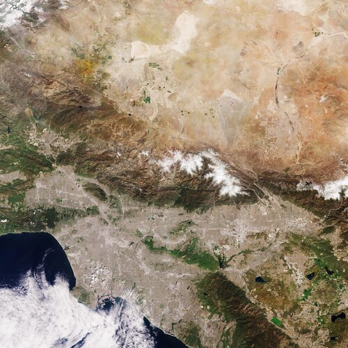 Image:
Captured by the Copernicus Sentinel-2 mission on 8 April 2023, this image shows Los Angeles and part of the hinterland in Southern California.
Image:
Captured by the Copernicus Sentinel-2 mission on 8 April 2023, this image shows Los Angeles and part of the hinterland in Southern California.
20230428_Odborný rada oddělení právních vztahů k nemovitostem
28.4.2023 9:23 ČÚZK /Urady/Katastralni-urady/Katastralni-urady/Katastralni-urad-pro-Stredocesky-kraj/Katastralni-pracoviste/KP-Rakovnik/O-uradu/Aktuality/20230111_Odborny-rada-oddeleni-pravnich-vztahu-(4)20230428_Odborný rada oddělení právních vztahů k nemovitostem
28.4.2023 9:23 ČÚZK - předpisy a opatření Katastrální úřad pro Středočeský kraj - Katastrální pracoviště Rakovník Vyhlášení výběrového řízení: odborný rada oddělení právních vztahů k nemovitostem V části "Úřední deska", v sekci "Oznámení a jiná úřední sdělení" bylo vystaveno "Oznámení o vyhlášení výběrového řízení na obsazení služebního místa odborný rada oddělení právních vztahů k nemovitostem"vrchní referent/rada – návrh zápisu v katastru
28.4.2023 6:37 ČÚZK - předpisy a opatření Katastrální úřad pro Olomoucký kraj Katastrální pracoviště Olomoucvypisuje výběrové řízení na místo
vrchní referent/rada – návrh zápisu v katastru
vrchní referent/rada – návrh zápisu v katastru
28.4.2023 6:37 ČÚZK - volná místa Katastrální úřad pro Olomoucký kraj Katastrální pracoviště Olomouc vypisuje výběrové řízení na místo vrchní referent/rada – návrh zápisu v katastruCo je verifikační registr DMVS, kde a kdy se do něj přihlásit
27.4.2023 18:36 ZeměměřičVerifikační registr DMVS slouží ke shromáždění kontaktů na vlastníky, správce a provozovatele (VSP) dopravní a technické infrastruktury (DTI), které ČÚZK dle bodu 3 přechodného ustanovení zákona č. 47/2020 Sb., kterým se mění mj. zákon č. 200/1994 Sb., o zeměměřictví a o změně a doplnění některých zákonů souvisejících s jeho zavedením, ve znění pozdějších předpisů (zeměměřický zákon), vyzve k registraci do Registru subjektů DMVS po jeho zprovoznění v termínu […]
The post Co je verifikační registr DMVS, kde a kdy se do něj přihlásit appeared first on Zeměměřič.
Program konference GIVS 2023, pořadatelem je Česká asociace pro geinformace
27.4.2023 15:27 ZeměměřičZačátkem května (2. – 3. května) se v Praze koná další ročník konference, známé častěji pod zkratkou GIVS, tedy Geoinformace ve veřejné správě. První blok konference je zaměřen na téma GeoInfoStrategie, vzdělávání a dopady zavádění BIM v ČR. Prvním přednášejícím v dopoledním bloku je Jitka Coufalová z Digitální a informační agentury, která představí implementaci projektu GeoInfoStrategie2020+. O vzdělávání v oblasti GIS bude hovořit Jiří […]
The post Program konference GIVS 2023, pořadatelem je Česká asociace pro geinformace appeared first on Zeměměřič.
Přihlášení do e-mailového informačního kanálu GEUSinfo
27.4.2023 15:19 GEUSware Zasílání aktuálních informací týkajících se našich produktů pro jejich uživatele, tedy se nejedná o marketingové informace, ale výhradně inforrmace týkající se používání těchto produktů - výpadky serverů, nové verze produktů apod.Oznámení
27.4.2023 13:52 ČÚZK - aktuality v resortu Český úřad zeměměřický a katastrální oznamuje, že dne 27. 4. 2023 od cca 10 do 13 hodin byla omezena dostupnost některých aplikací v důsledku přetížení části infrastruktury kybernetickým bezpečnostním incidentem. Přes provedená opatření nelze zcela vyloučit opakování. Omlouváme se za případné problémy.Oznámení
27.4.2023 13:52 ČÚZK - předpisy a opatření Český úřad zeměměřický a katastrálnízveřejnil novou aktualitu: Český úřad zeměměřický a katastrální oznamuje, že dne 27. 4. 2023 od cca 10 do 13 hodin byla omezena dostupnost některých aplikací v důsledku přetížení části infrastruktury kybernetickým bezpečnostním incidentem. Přes provedená opatření nelze zcela vyloučit opakování. Omlouváme se za případné problémy.
Přerušení dodávky elektřiny
27.4.2023 11:49 ČÚZK - předpisy a opatření Katastrální úřad pro Moravskoslezský kraj - Katastrální pracoviště Frýdek-Místek zveřejnil novou aktualitu: Přerušení dodávky elektřinyKatastrální úřad pro Moravskoslezský kraj, Katastrální pracoviště Frýdek-Místek informuje, že společnost ČEZ Distribuce, a. s. oznámila na adrese sídla pracoviště, tř. T.G. Masaryka, na pátek dne 5. 5. 2023 v době od 7:00 do 11:00 hodin přerušení dodávky elektřiny. Z uvedeného důvodu budou v tento den služby v budově Katastrálního pracoviště Frýdek-Místek omezeny pouze na přijetí podání na podatelně úřadu.
Děkujeme za pochopení.
Přerušení dodávky elektřiny
27.4.2023 11:49 ČÚZK /Urady/Katastralni-urady/Katastralni-urady/Katastralni-urad-pro-Moravskoslezsky-kraj/Katastralni-pracoviste/KP-Frydek-Mistek/O-uradu/Aktuality/Preruseni-dodavky-elektrinyEU Space at the heart of the EU Maritime Security Strategy
27.4.2023 9:43 European GNSS Agency
Home to over 300 of the world’s main seaports and nearly 30% of the global merchant fleet, maritime transportation plays a big role in the European economy. In particular, the EU controls c.a. 30% of the world merchant fleet. That’s why the EU goes to great lengths to ensure its security.
The EU Maritime Security Strategy (EUMSS) promotes international peace and security, respect for international rules and principles, and the sustainability of our oceans with the goal of providing safe maritime operations .
But, while its focus may be at sea level, the EUMSS very much depends on space.
“Whether it be Earth Observation data from Copernicus, the precise positioning offered by Galileo and EGNOS, or the secure communications of IRIS2 and GOVSATCOM, the services and data provided by the EU Space Programme can go a long way in securing the maritime transport sector,” says EUSPA Executive Director, Rodrigo da Costa.

Commercial vessels queuing outside the port of Piraeus, Greece as seen from Copernicus Sentinel-2
Safety at sea starts with Galileo
GNSS is a critical technology used in maritime navigation systems. However, GNSS signals are vulnerable to interference and spoofing, which can cause user navigation systems to obtain faulty information. Intentional satellite interreference is not a new issue, but, in recent years the maritime industry has been increasingly facing GNSS spoofing incidents (Black Sea in 2017, Shanghai 2019, Louisiana 2020). Erroneous data of a vessel’s position, speed and direction poses real threats to its own operations, but also to surrounding ships, especially those carrying dangerous goods. Between leaving both crew and shipments vulnerable to hijacking and theft and the risk of guiding a vessel off course, the implications of falsifying GNSS signals can negatively impact the Union’s blue economy.
To increase the robustness against GNSS attacks, the EU is currently testing the Galileo OSNMA service. This forthcoming service is an authentication mechanism that allows GNSS receivers to verify the authenticity of GNSS information, ensuring that the data they receive are indeed from Galileo and have not been modified in any way.
EUSPA-funded, ASGARD project is working to integrate the ONSMA capability in dual frequency shipborne receivers. The main goal is to increase the adoption of Galileo in maritime in order to detect and alert vessels that are under spoofing attacks.
Moreover, Galileo is also an important tool in maritime transportation. Thanks to the increased accuracy, coverage and resiliency it brings, the sector has benefited from better prediction of vessel location, a decrease in collisions, and more efficient manoeuvrings. Galileo has even helped the sector reduce its environmental footprint.
There’s also the ground-breaking Galileo Return Link Service (RLS), which is part of the Galileo Search and Rescue (SAR) service. Thanks to the RLS, sailors in distress, when equipped with the appropriate beacon, will see a light verifying that their distress signal has been received by emergency first responders and that their location has been established.
Europe’s eyes on the sea
Accidents often occur in poor weather conditions where it is difficult or dangerous to deploy manned assets (e.g., helicopters). When an accident happens in a remote area, there may not be the option to send vessels or aircraft to verify the situation. In both contexts, the Copernicus Maritime Surveillance (implemented by EMSA) service can provide valuable additional data to help detect, track and potentially identify the vessels in distress. By doing so, the CMS helps support Search and Rescue efforts.
More specifically, Copernicus utilises Synthetic Aperture Radar (SAR) images to detect vessels over large areas, this is particularly valuable during the night and through clouds. This capability is especially useful when a vessel loses communication and goes adrift (e.g., following a fire or tracking storm damage). Identifying the location of a vessel optimises the use of search and rescue assets and allows authorities to direct resources to where they are of most use. Optical images can also provide a wealth of information, such as characterising the damage caused or detecting any deployed lifeboats. SAR images generated by Copernicus Sentinel-1 also allow for oil spill detections in remote locations such as the Arctic circle. When combined with GNSS positioning from AIS, authorities can swiftly reach the spill site, understand the extent of the risk and implement necessary actions.
How the EU Space Programme helps address the new challenges of a changing Arctic
Uninterrupted, secure communications across the oceans
Last, are the two new components of the EU Space Programme IRIS2 and GOVSATCOM. Both are set to ensure uninterrupted communications, even on the open seas. With the addition of IRIS2, the European Union is ramping up digitisation of European society and its economy while looking to make space data more accessible and scalable to many communities, maritime included. The combination of MEO and LEO capabilities of IRIS2 will enable the provision of seamless internet connectivity throughout the Union but also around the world, removing communication dead zones. This will be particularly useful for maritime operators who must communicate with the crew onboard the vessel.
Read this: EU Space enables safer maritime operations
Your partner in maritime safety and security
While the EU Space Programme provides European maritime operators, seafarers and national authorities with tools to enhance safety at sea, optimise navigation performance and protect the oceans, EUSPA itself continually partners with the sector to further leverage the benefits of EU Space.
“As a user-oriented agency, EUSPA closely follows the needs of maritime users, working together to shape and deliver new space-based services that will further enhance the security and effectiveness of this critical sector,’’ adds da Costa.
For instance, EUSPA has been working with such relevant organisations as the European Fisheries Control Agency (EFCA) and the European Maritime Safety Agency (EMSA) to develop space-based solutions related to navigation, search and rescue and fisheries control.
EUSPA also contributes to the EFCA and EMSA’s annual workshops, both of which focus on the use of new technologies – including drones – for fisheries surveillance and operational inspections respectively. The EFCA has invited EUSPA to their next annual meeting on 3 May, leveraging the memorandum of understanding between the two agencies, to present the latest work of several EUSPA-supported projects, including Blue Box Porbeagle, which is developing a VMS transceiver using the Galileo Open Service Navigation Message Authentication (OSNMA) service, and GAMBAS, an initiative working on a Ship Security Alert System (SSAS) with Galileo return link capability.
In addition to this work with maritime agencies, EUSPA also supports the sector through awareness raising measures by providing key market intelligence like our EO and GNSS Market Report, and by offering a range of funding opportunities.
To learn more about our work in the maritime sector, please contact us at market@euspa.europa.eu. Or download our brochure here.
Media note: This feature can be republished without charge provided the European Union Agency for the Space Programme (EUSPA) is acknowledged as the source at the top or the bottom of the story. You must request permission before you use any of the photographs on the site. If you republish, we would be grateful if you could link back to the EUSPA website (http://www.euspa.europa.eu).
Výběrové řízení na pozici vedoucí ekonomického oddělení Kanceláře úřadu Katastrálního úřadu pro Král
27.4.2023 7:17 ČÚZK - volná místa Katastrální úřad pro Královéhradecký kraj kancelář ředitele vypisuje výběrové řízení na místo Výběrové řízení na pozici vedoucí ekonomického oddělení Kanceláře úřadu Katastrálního úřadu pro KrálVýběrové řízení na pozici vedoucí ekonomického oddělení Kanceláře úřadu Katastrálního úřadu pro Král
27.4.2023 7:17 ČÚZK /Urady/Katastralni-urady/Katastralni-urady/Katastralni-urad-pro-Kralovehradecky-kraj/Volna-mista/DMS/Vyberove-rizeni-na-pozici-vedouci-ekonomickeho-oddVýběrové řízení na pozici vedoucí ekonomického oddělení Kanceláře úřadu Katastrálního úřadu pro Král
27.4.2023 7:17 ČÚZK - předpisy a opatření Katastrální úřad pro Královéhradecký kraj kancelář ředitelevypisuje výběrové řízení na místo
Výběrové řízení na pozici vedoucí ekonomického oddělení Kanceláře úřadu Katastrálního úřadu pro Královéhradecký kraj
Upozornění - 1.5. a 8.5.2023 [Knihovna geografie, byTopic]
27.4.2023 0:00 Katedra aplikované geoinformatiky a kartografie Přf UK Z důvodu státních svátků bude knihovna geografie v pondělí 1.5.2023 (Svátek práce)a v pondělí 8.5.2023 (Den vítězství) uzavřena!
The Strategic Roadmap for buildingSMART
26.4.2023 22:35 buildingSMART.orgIn one of my first blogs in this role, I set out as a priority the creation of a Strategic Roadmap for buildingSMART International. My goal was to help guide the work…
The post The Strategic Roadmap for buildingSMART appeared first on buildingSMART International.
The Strategic Roadmap for buildingSMART
26.4.2023 22:35 buildingSMART.orgIn one of my first blogs in this role, I set out as a priority the creation of a Strategic Roadmap for buildingSMART International so that we can develop interoperable standards,…
The post The Strategic Roadmap for buildingSMART appeared first on buildingSMART International.
Krátka správa č. 22/2023
26.4.2023 19:47 Komora geodetů a kartografů SRThe post Krátka správa č. 22/2023 appeared first on Komora geodetov a kartografov.
Krátka správa č. 22/2023
26.4.2023 19:47 Komora geodetů a kartografů SRThe post Krátka správa č. 22/2023 appeared first on Komora geodetov a kartografov.
Srdečně vás zveme na první konferenci CADfórum na Slovensku
26.4.2023 18:23 Arkance SystemsArkance Systems pořádá 7. června 2023 první CADfórum na Slovensku. Nejnovější trendy a Průmysl 4.0 přímo ve Sliači.
Zpráva Srdečně vás zveme na první konferenci CADfórum na Slovensku pochází z arkance-systems.cz.
CryoSat reveals ice loss from glaciers
26.4.2023 15:00 ESA Observing the Earth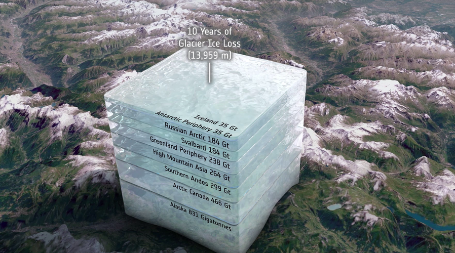
When one thinks of the damage that climate change is doing, it’s probable that what comes to mind is a vision of huge lumps of ice dropping off one of the polar ice sheets and crashing into the ocean. While Greenland and Antarctica are losing masses of ice, so too are most of the glaciers around the world, but it’s tricky to measure how much ice they are shedding.
Thanks to ESA’s CryoSat satellite and a breakthrough way of using its data, scientists have discovered that glaciers worldwide have shrunk by a total of 2% in just 10 years, and it’s because of higher air temperatures.
Geodet/ka
26.4.2023 14:19 ČÚZK - volná místa Zeměměřický úřad vypisuje výběrové řízení na místo Geodet/kaGeodet/ka
26.4.2023 14:19 ČÚZK - předpisy a opatření Zeměměřický úřadvypisuje výběrové řízení na místo
Geodet/ka
Geodet/ka
26.4.2023 14:19 Zeměměřický úřad Zeměměřický úřadvypisuje výběrové řízení na místo
Geodet/ka
20230426
26.4.2023 12:56 ČÚZK - předpisy a opatření Český úřad zeměměřický a katastrální zveřejnil novou aktualitu: Zkoušky ÚOZI se budou konat ve dnech 10. a 11. května 2023.20230426
26.4.2023 12:56 ČÚZK - aktuality v resortu Zkoušky ÚOZI se budou konat ve dnech 10. a 11. května 2023.NEW SatLab HydroBoat 990 Bathymetric USV System – Efficiency in Every Echo!
26.4.2023 4:55 Satlab Geosolutions https://www.youtube.com/watch?v=5twfgrUV7aQSatLab newly released an One-Man Solution for bathymetric surveys to improve efficiency in every echo! […]NEW SatLab HydroBoat 990 Bathymetric USV System – Efficiency in Every Echo!
26.4.2023 4:55 Satlab Geosolutionshttps://www.youtube.com/watch?v=5twfgrUV7aQSatLab newly released an One-Man Solution for bathymetric surveys to improve efficiency in every echo! […]
The post NEW SatLab HydroBoat 990 Bathymetric USV System – Efficiency in Every Echo! appeared first on Global Satellite Positioning Solutions | SatLab Geosolutions AB.
NEW SatLab HydroBoat 990 Bathymetric USV System – Efficiency in Every Echo!
26.4.2023 4:55 Satlab Geosolutions https://www.youtube.com/watch?v=5twfgrUV7aQSatLab newly released an One-Man Solution for bathymetric surveys to improve efficiency in every echo! […]Výstava „Vltava - proměny historické krajiny“ [Knihovna geografie, byTopic]
26.4.2023 0:00 Katedra aplikované geoinformatiky a kartografie Přf UK Středočeské muzeum v Roztokách u Prahy srdečně zve na výstavu o proměnách krajiny okolo Vltavy v moderní době. Nenechte si rovněž ujít slavnostní vernisáž, jež se koná příští čtvrtek 4.5.2023 v 17 hodin v prostorách muzea (Zámek 1).Změna výpůjční doby 26.4.2023 [Knihovna geografie, byTopic]
26.4.2023 0:00 Katedra aplikované geoinformatiky a kartografie Přf UKVe středu 26. dubna 2023 bude Knihovna geografie z provozních důvodů otevřena pouze do 16,00 hod. Děkujeme za pochopení.
The future of gravity is MAGIC
25.4.2023 16:08 ESA Observing the Earth
The latest European State of the Climate report states that, last year, Europe suffered its hottest summer on record. The heat and a persistent lack of rain caused drought which, at its peak, affected much of the continent. This not only illustrates the reality of climate change, but also how precarious our supply of freshwater can be, even in western Europe where the climate is relatively moderate.
By delivering frequent and accurate gravity measurements, a new space mission called MAGIC, a cooperation between ESA and NASA, will help make the important task of managing our precious water supplies more efficient.
odborný/vrchní referent - personalista/ka v kanceláři ředitele Katastrálního úřadu pro Jihočeský kra
25.4.2023 13:22 ČÚZK - předpisy a opatření Katastrální úřad pro Jihočeský kraj kancelář ředitelevypisuje výběrové řízení na místo
odborný/vrchní referent - personalista/ka v kanceláři ředitele Katastrálního úřadu pro Jihočeský kraj (ID SM: 30000022/30003646)
Systémový inženýr/ka
25.4.2023 12:35 ČÚZK /Urady/Zememericky-urad/Volna-mista/DMS/Systemovy-inzenyr-kaSystémový inženýr/ka
25.4.2023 12:35 ČÚZK - předpisy a opatření Zeměměřický úřadvypisuje výběrové řízení na místo
Systémový inženýr/ka
Systémový inženýr/ka
25.4.2023 12:35 Zeměměřický úřad Zeměměřický úřadvypisuje výběrové řízení na místo
Systémový inženýr/ka
Systémový inženýr/ka
25.4.2023 12:35 ČÚZK - volná místa Zeměměřický úřad vypisuje výběrové řízení na místo Systémový inženýr/ka20230425_Vrchní referent / rada oddělení aktualizace KN
25.4.2023 10:58 ČÚZK - předpisy a opatření Katastrální úřad pro Středočeský kraj - Katastrální pracoviště Příbram Vyhlášení výběrového řízení: Vrchní referent / rada oddělení aktualizace KN V části "Úřední deska", v sekci "Oznámení a jiná úřední sdělení" bylo vystaveno "Oznámení o vyhlášení výběrového řízení na obsazení služebního místa Vrchní referent / rada oddělení aktualizace KN"20230425_Vrchní referent / rada oddělení aktualizace KN
25.4.2023 10:58 ČÚZK /Urady/Katastralni-urady/Katastralni-urady/Katastralni-urad-pro-Stredocesky-kraj/Katastralni-pracoviste/KP-Pribram/O-uradu/Aktuality/20210922_Odborny-referent-oddeleni-aktualizace-(1)Geodetem na Správě veřejného statku města Plzně?
24.4.2023 16:41 Blogující geomatici - FAV ZČUSpráva veřejného statku města Plzně, příspěvková organizace vyhlašuje výběrové řízení na obsazení místa geodet/ka.
Pracovní úvazek: 1,0 (40 hodin týdně), pružná pracovní doba PO-PÁMísto výkonu práce: Plzeň
Pracovní poměr: na dobu určitou na jeden rok, s možností změny na dobu neurčitou
Předpokládaný datum nástupu: po domluvě
Platová třída: 9-10, tj. v rozmezí 21 710 – 34 370,- Kč + pohyblivá složka platu (osobní příplatek, odměny). Plat se řídí dle NV č. 264/2022 Sb. a záleží na dosažené praxi a vzdělání.
geodetické činnosti v terénu i kanceláři
tvorba geometrických plánů, vytyčování hranic pozemků, zaměřování skutečného stavu, vyhotovování podkladů pro projekty
komunikace se zákazníky
vzdělání – SŠ/VŠ – zeměměřického směru - podmínkou
řidičský průkaz skupiny B,
znalost práce na PC (word, excel).
znalost programů Geus, Geometr, MicroStation výhodou
samostatnost, odpovědnost
vhodné i pro absolventy
praxe výhodou
zajímavá, koncepční práce a perspektivní zaměstnání,
získání praxe pro zkoušky ÚOZI pro VŠ
motivující osobní příplatek, mimořádné odměny a další zaměstnanecké výhody
(příspěvek na penzijní připojištění, stravenkový paušál, sick days (indispoziční volno), výhodnější paušály na volání, 5 týdnů dovolené).
Doklady potřebné pro přihlášení do výběrového řízení:
1. strukturovaný životopis,
2. podepsané prohlášení uchazeče v následujícím znění: Poskytnutím svých osobních údajů v rozsahu podkladů pro přihlášku do výběrového řízení dávám souhlas k jejich zpracování (jméno, příjmení, titul, datum narození, podpis).
Stačí tuto větu připojit na konec životopisu.
Bližší informace na telefonu č. 378 037 075, Ing. Martin Novák, vedoucí geodetického oddělení
Nedostupné produkční ISÚI a VDP
24.4.2023 14:44 ČÚZK /ruian/Editacni-agendovy-system-ISUI/Provozni-informace-a-odstavky/Archiv-PROD/Nedostupne-produkcni-ISUI-a-VDP-(5)Podepisování v GEUSu hlásí chybu, nelze podepsat GP ani ZPMZ
24.4.2023 14:42 GEUSware Nelze podepisovat soubory GP a ZPMZ v GEUSu. Na odstranění chyby usilovně pracujeme, jakmile to bude možné, vydáme nové sestavení GEUS 27.0.Nelze podepsat GP v GEUSu - vydána oprava
24.4.2023 14:42 GEUSware Nelze podepisovat soubory GP v GEUSu, podepisování skončí chybou. Byla vydána oprava. Více informací v článku.Podepisování v GEUSu hlásí chybu, nelze podepsat GP ani ZPMZ
24.4.2023 14:42 GEUSware Nelze podepisovat soubory GP v GEUSu, podepisování skončí chybou. Byla vydána oprava. Více informací v článku.Přerušení provozu DP a WSDP v pátek 28.4.2023 od 15:30 do cca 23:00.
24.4.2023 14:27 ČÚZK - předpisy a opatření Vážení uživatelé,oznamujeme, že v pátek 28.4.2023 od 15:30 bude z provozních důvodů zcela přerušen provoz Dálkového přístupu i Webových služeb dálkového přístupu. Obnovení provozu předpokládáme v cca 23 hodin. U této verze nedochází ke změnám webových služeb.
Za komplikace tímto způsobené se omlouváme a děkujeme za pochopení.
Přerušení provozu DP a WSDP v pátek 28.4.2023 od 15:30 do cca 23:00.
24.4.2023 14:27 ČÚZK /Aplikace-DP-do-KN/Aplikace-DP-do-KN/Archiv-DP/384454Přerušení provozu DP a WSDP v pátek 28.4.2023 od 15:30 do cca 23:00.
24.4.2023 14:27 Dálkový přístup k údajům KN ČR Vážení uživatelé,oznamujeme, že v pátek 28.4.2023 od 15:30 bude z provozních důvodů zcela přerušen provoz Dálkového přístupu i Webových služeb dálkového přístupu. Obnovení provozu předpokládáme v cca 23 hodin. U této verze nedochází ke změnám webových služeb.
Za komplikace tímto způsobené se omlouváme a děkujeme za pochopení.
20230425 - volné místo - Odborný/vrchní referent v PEO katastrálního úřadu na KÚ pro Ústecký kraj
24.4.2023 13:41 ČÚZK - předpisy a opatření Katastrální úřad pro Ústecký kraj zveřejnil novou aktualitu: Nabídka volného místa - Odborný / vrchní referent v personálním oddělení kanceláře ředitele katastrálního úřadu na Katastrálním úřadu pro Ústecký kraj20230425 - volné místo - Odborný/vrchní referent v PEO katastrálního úřadu na KÚ pro Ústecký kraj
24.4.2023 13:41 ČÚZK /Urady/Katastralni-urady/Katastralni-urady/Katastralni-urad-pro-Ustecky-kraj/O-uradu/Aktuality/20230425-volne-misto-Odborny-vrchni-referent-v-PEOOdborný / vrchní referent v personálním oddělení kanceláře ředitele katastrálního úřadu na Katastrál
24.4.2023 13:35 ČÚZK - volná místa Katastrální úřad pro Ústecký kraj kancelář ředitele vypisuje výběrové řízení na místo Odborný / vrchní referent v personálním oddělení kanceláře ředitele katastrálního úřadu na KatastrálOdborný / vrchní referent v personálním oddělení kanceláře ředitele katastrálního úřadu na Katastrál
24.4.2023 13:35 ČÚZK /Urady/Katastralni-urady/Katastralni-urady/Katastralni-urad-pro-Ustecky-kraj/Uredni-deska/Oznameni-a-jina-uredni-sdeleni/Volna-mista/DMS/Odborny-vrchni-referent-v-personalnim-oddeleni-kanOdborný / vrchní referent v personálním oddělení kanceláře ředitele katastrálního úřadu na Katastrál
24.4.2023 13:35 ČÚZK - předpisy a opatření Katastrální úřad pro Ústecký kraj kancelář ředitelevypisuje výběrové řízení na místo
Odborný / vrchní referent v personálním oddělení kanceláře ředitele katastrálního úřadu na Katastrálním úřadu pro Ústecký kraj
referent/vrchní referent – vedení katastrální mapy
24.4.2023 12:34 ČÚZK - předpisy a opatření Katastrální úřad pro hlavní město Prahuvypisuje výběrové řízení na místo
referent/vrchní referent – vedení katastrální mapy
referent/vrchní referent – vedení katastrální mapy
24.4.2023 12:34 ČÚZK - volná místa Katastrální úřad pro hlavní město Prahu vypisuje výběrové řízení na místo referent/vrchní referent – vedení katastrální mapyOdborný referent v oddělení obnovy katastrálního operátu č.3 na Technické sekci
24.4.2023 11:34 ČÚZK - předpisy a opatření Katastrální úřad pro Jihomoravský kraj technická sekcevypisuje výběrové řízení na místo
Odborný referent v oddělení obnovy katastrálního operátu č.3 na Technické sekci
Odborný referent v oddělení obnovy katastrálního operátu č.3 na Technické sekci
24.4.2023 11:34 ČÚZK /Urady/Katastralni-urady/Katastralni-urady/Katastralni-urad-pro-Jihomoravsky-kraj/Uredni-deska/Oznameni-a-jina-uredni-sdeleni/Volna-mista/DMS/Odborny-referent-v-oddeleni-obnovy-katastralniho-oOdborný referent v oddělení obnovy katastrálního operátu č.3 na Technické sekci
24.4.2023 11:34 ČÚZK - volná místa Katastrální úřad pro Jihomoravský kraj technická sekce vypisuje výběrové řízení na místo Odborný referent v oddělení obnovy katastrálního operátu č.3 na Technické sekciKvětnový den s CAD technikem – bezplatná online konzultace pro vaši firmu
24.4.2023 8:00 Arkance Systems26. května 2023 - přihlaste se na nový termín akce společnosti Arkance Systems. Těšíme se na vás.
Zpráva Květnový den s CAD technikem – bezplatná online konzultace pro vaši firmu pochází z arkance-systems.cz.
Nominace na ocenění MAPA ROKU 2022. Přijďte na vyhlášení výsledků!
23.4.2023 19:20 Česká kartografická společnostOdborná komise České kartografické společnosti na svém zasedání zhodnotila všechny přihlášené produkty a nominovala na ocenění Mapa roku 2022. Slavnostní vyhlášení výsledků soutěže se uskuteční ve středu 3. května 2023 od 12:30 hodin v Praze na Novotného lávce 5. Srdečně zveme nejen všechny nominované na ocenění Mapa roku 2022, ale i všechny příznivce soutěže a zájemce o […]
The post Nominace na ocenění MAPA ROKU 2022. Přijďte na vyhlášení výsledků! first appeared on Česká kartografická společnost.
DAEX DESIGN Professional včetně akčních modulů
23.4.2023 17:34 ŠPINAR - softwarePřipravili jsme pro Vás Příklady vizualizací a zdroje světel pro DAEX DESIGN Standard, Plus a Pro v2
The post DAEX DESIGN Professional včetně akčních modulů appeared first on ŠPINAR – software.
DAEX DESIGN Professional s akčními moduly
23.4.2023 17:34 ŠPINAR - softwareVážení truhláři, nábytkáři, designeři a návrháři interiérů, připravili jsme pro Vás DAEX DESIGN Pro s akčními moduly.
The post DAEX DESIGN Professional s akčními moduly appeared first on ŠPINAR – software.
DAEX DESIGN Professional s akčními moduly
23.4.2023 17:34 ŠPINAR - software Vážení truhláři, nábytkáři, designeři a návrháři interiérů, připravili jsme pro Vás DAEX DESIGN Pro s akčními moduly.DAEX DESIGN Professional s akčními moduly
23.4.2023 17:34 ŠPINAR - softwareVážení truhláři, nábytkáři, designeři a návrháři interiérů, připravili jsme pro Vás DAEX DESIGN Pro s akčními moduly.
The post DAEX DESIGN Professional s akčními moduly appeared first on ŠPINAR – software.
Příklady vizualizací a zdroje světel pro DAEX DESIGN 2
23.4.2023 12:16 ŠPINAR - softwarePřipravili jsme pro Vás Příklady vizualizací a zdroje světel pro DAEX DESIGN Standard, Plus a Pro v2
The post Příklady vizualizací a zdroje světel pro DAEX DESIGN 2 appeared first on ŠPINAR – software.
Příklady vizualizací a zdroje světel pro DAEX DESIGN
23.4.2023 12:16 ŠPINAR - software Připravili jsme pro Vás Příklady vizualizací a zdroje světel v2 pro DAEX DESIGN Standard, Plus a Pro 23Příklad vizualizace a zdroje světel pro DAEX DESIGN 2
23.4.2023 12:16 ŠPINAR - softwarePřipravili jsme pro Vás Příklad vizualizace a zdroje světel pro DAEX DESIGN Standard, Plus a Pro v2
The post Příklad vizualizace a zdroje světel pro DAEX DESIGN 2 appeared first on ŠPINAR – software.
Příklady vizualizací a zdroje světel pro DAEX DESIGN
23.4.2023 12:16 ŠPINAR - softwarePřipravili jsme pro Vás Příklady vizualizací a zdroje světel v2 pro DAEX DESIGN Standard, Plus a Pro 23
The post Příklady vizualizací a zdroje světel pro DAEX DESIGN appeared first on ŠPINAR – software.
Příklad vizualizace a zdroje světel pro DAEX DESIGN 2
23.4.2023 12:16 ŠPINAR - softwarePřipravili jsme pro Vás Příklady vizualizací a zdroje světel pro DAEX DESIGN Standard, Plus a Pro v2
The post Příklad vizualizace a zdroje světel pro DAEX DESIGN 2 appeared first on ŠPINAR – software.
GISáček 2023: uzávierka abstraktov
23.4.2023 9:51 Geocommunity.skPríspevok GISáček 2023: uzávierka abstraktov zobrazený najskôr GeoCommunity.sk.
GISáček 2023: uzávierka abstraktov
23.4.2023 9:51 Geocommunity.skPríspevok GISáček 2023: uzávierka abstraktov zobrazený najskôr GeoCommunity.sk.
9. jednání TPS
22.4.2023 0:36 ČÚZK - předpisy a opatření Dne 10. května 2023 proběhne distančně 9. jednání Technické pracovní skupiny Koordinační rady správců DMVS a DTM.Earth Day 2023: Uncovering Europe’s much needed critical raw materials from space
21.4.2023 14:45 European GNSS Agency
What do semiconductor chips, electric vehicles, solar panels, heat pumps, wind turbines and clean energy technologies have in common?
They all depend on having ready access to critical raw materials like lithium.
“Raw materials are the essential ingredient to achieving our ambitious climate targets,” says EU Commissioner for the Internal Market Commissioner Thierry Breton. “Without the necessary raw materials, there can be no green transition.”
According to a recent Eurometaux study, this transition will require huge amounts of raw materials, including aluminium, copper, lithium, nickel, zinc, silicon and cobalt. To give you an idea of what we mean by huge, the report notes that Europe will require 330% more cobalt and a whopping 3,500% increase in lithium. This has been complemented by the study written by the Joint Research Centre of the European Commission.
The problem is Europe simply doesn’t have the capacity to supply enough raw material to meet this demand. As a result, it has traditionally imported its raw materials from the likes of China and Russia. But this dependency means importing materials that are often mined in unsustainable or unresponsible ways. It also makes the EU vulnerable to having its supply cut off, which is exactly what happened following Russia’s invasion of Ukraine.
“Without secure and sustainable access to the necessary raw materials, our ambition to become the first climate neutral continent is at risk,” says European Commission President Ursula von der Leyen.
In an effort to mitigate its dependence on the extraction, processing and recycling of raw materials, the EU has launched the European Critical Raw Materials Act. The Act aims to build up reserves where supply is at risk by identifying potential strategic projects along the entire supply chain – from extraction to refining, processing and recycling.
And when it comes to efficiently extracting raw materials from the ground, there’s no better place to start than space.
With the raw materials sector already leveraging the benefits of GNSS and Earth Observation for everything from exploration to site approval, construction, operations and closure, EU Space is well-placed to play a pivotal role in ensuring the rare earth independence envisioned by the European Critical Raw Materials Act.
Two powerful tools for the mining sector
Take Earth Observation (EO). The European Commission’s Action Plan on Raw Materials, a precursor to the Critical Raw Materials Act, specifically proposes deploying EO programmes and remote sensing for resource exploration and mining operations.
The raw materials sector is already using hyperspectral imagery to assess the abundancy of certain minerals at a potential site. When the site is up and running, high-resolution EO data is used to monitor many aspects of a plant’s operations, including pit slopes and ground motion effects.
The data provided by such Earth Observation programmes as Copernicus complements and enhances traditional detection methods by reducing location errors and providing faster, more accurate information on asset concentration and commercial yields.
But this is, as they say, just the tip of the iceberg. According to EUSPA’s 2022 EO and GNSS Market Report, as the technology continues to mature, the EO sector will soon offer fit-for-purpose, turn-key solutions that the mining industry can integrate into their own workflows and systems.
Mining also depends on GNSS. In fact, the sector was an early adapter of augmented GNSS solutions, using it for everything from surveying mining sites to accessing remote areas and enabling the safe operation of heavy machinery. Today, with many activities being increasingly automated, GNSS has become a key enabler for the management of mining operations.
The use of high-accuracy GNSS in particular is used for such tasks as grading, dozing, drilling, collision avoidance and fleet management. It’s also a key tool for machine guidance, with the determination of excavator bucket wheel position being a critical GNSS application.
While GNSS and Earth Observation are powerful tools in their own right, the raw materials sector stands to benefit the most when these solutions are used in synergy. For example, mining companies can use services enabled by EO and GNSS data to not only identify the most suitable areas for extracting raw materials, but also to aid in the permitting process, plan their development and monitor their operations. By assessing stability of pit slopes of tailings dams, their combined use is also improving safety around mining operations.
Keeping the green transformation clean
With all this being said, we cannot ignore the significant environmental impact raw material extraction has. According to EUSPA’s EU Space for Green Transformation Report, mining is amongst the most environmentally harmful activities, impacting land, water, air, biodiversity and human health.
Thus, as Europe moves forward to secure the raw materials it needs to enable its green transition, it needs to do so in a way that aligns with its climate and environmental priorities.
Here too, EU Space can help.
While Earth Observation services may bring the most value in mineral exploration, ground stability monitoring and planning of mining sites, environmental monitoring also draws on EO powered solutions – especially when it comes to post-closure environmental management. For instance, when a mining site closes, companies can use EO data to guide their site clean-up, rehabilitation and waste management.
GNSS also helps mining reduce its environmental footprint. By optimising fleet management during mining operations, it is estimated that the use of precise navigation services can improve the efficiency of mining equipment, especially trucks, in terms of fuel consumption from 1.8 to 2.3%. Furthermore, Galileo-enabled location-based services can be used throughout industry to track and optimise operations like warehousing and further reduce direct emissions.
Although accurate positioning is important, it alone is not enough. Robustness and resiliency are critical too. Here, companies like Septentrio, which manufactures GNSS components and receivers, are using proprietary algorithms to improve positioning robustness and resilience during operations. As a result, mining companies can maximise efficiency, achieve the highest levels of safety, optimise the utilisation of natural resources and help safeguard the integrity of surrounding ecosystems.
Not only does EU Space help secure the raw materials needed to enable Europe’s green transition, it also ensures the processes for doing so don’t compromise our other sustainability goals.
Media note: This feature can be republished without charge provided the European Union Agency for the Space Programme (EUSPA) is acknowledged as the source at the top or the bottom of the story. You must request permission before you use any of the photographs on the site. If you republish, we would be grateful if you could link back to the EUSPA website (http://www.euspa.europa.eu).
Earth from Space: Rome, Italy
21.4.2023 10:00 ESA Observing the Earth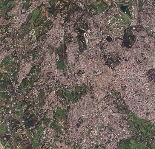 Image:
The historic centre of Rome, Italy’s capital city, is featured in this image captured on 28 March 2023.
Image:
The historic centre of Rome, Italy’s capital city, is featured in this image captured on 28 March 2023.
Vyšla aktualizace ArcGIS Enterprise 11.1
21.4.2023 9:00 ARCDATATento týden vyšla aktualizovaná verze ArcGIS Enterprise 11.1. Vybrali jsme pro vás několik nejzajímavějších novinek, které přináší. Pokud chcete znát všechny změny, doporučujeme vaší pozornosti článek na stránkách Esri.
- Webhooky pro feature služby a asynchronní geoprocessingové služby. Kromě stávajících webhooků v ArcGIS Enterprise (například těch pro obsah, uživatele nebo skupiny) budete mít nyní možnost publikovat i webhooky, které se spouštějí na feature a asynchronních geoprocessingových službách (job status), což poskytuje příležitost pro větší integraci se stávajícími podnikovými IT pracovními postupy – například s platformou Microsoft Power Platform. Dojde tak k napojení různých procesů na akce vytvořit, číst, aktualizovat, smazat (CRUD).
- Custom data feeds. Tato novinka umožňuje uživatelům využít svá data pomocí ArcGIS Enterprise, aniž by je do ArcGIS Enterprise museli registrovat nebo fyzicky nahrát. Data mohou zůstat ve svém původním formátu, který nemusí být nativním formátem podporovaným systémem ArcGIS. Uživatelé nastaví tento datový feed pomocí JavaScriptového kódu a v rámci ArcGIS Enterprise se bude tvářit jako feature služba (s omezením na čtení dat). Jedná se o velmi užitečný nástroj, kterým rozšíříte možnosti zobrazování dat na ArcGIS Enterprise, a tím i v celém systému ArcGIS.
- Map Viewer nově umožňuje přímé načtení souborů geoJSON a CSV a v jeho pop-upech bude možné zobrazit relačně navázané záznamy. Záznamy z tabulek a vrstev bude také možné zobrazovat pomocí výsečových grafů. A v případě symboliky se můžete těšit na vícebarevné vektorové symboly.
- V nové verzi ArcGIS Enterprise se také setkáte s vylepšeným editorem Arcade pro pohodlnější psaní výrazů.
- Webové scéně nyní můžete vdechnout život díky efektům počasí a přidat na realističnosti s 3D vrstvami budov a stromů zpracovaných na základě OpenStreetMap.
- V ArcGIS Dashboards, konkrétně ve widgetu List, budete moci nově vyhledávat a také se můžete těšit na nové akce. Sumarizovaná data bude možné stáhnout do tabulky CSV.
- Na pozadí můžete sledovat v rozšířeném editor tracking i události jako přidat/upravit/smazat. Velmi užitečným postupem pak bude možnost nahrazení zdroje.
- Vylepšením, které známe i z ArcGIS Pro 3.1, je možnost nastavit informaci o časové zóně, která se liší od databázového času či výchozího UTC.
- Pokud využíváte rozšíření ArcGIS Enterprise s publikovanými webovými nástroji z ArcGIS Notebooks, potěší vás, že nedávná vylepšení umožní uživatelům snadno aktualizovat a přepisovat stávající webové nástroje z aktualizovaných ArcGIS Notebooks.
- Máte-li v rámci vašeho prostředí ještě služby publikované z ArcMap, aktualizační proces automaticky zmigruje služby postavené na runtime ArcMapu a pro mapové, image a geodatové služby použije runtime ArcGIS Pro. Výsledek upgradu shrne do reportu, kde například uvidíte ty služby, které vyžadují další pozornost (obsahují staré SOI/SOE, nepodporované vrstvy a databáze...) s popiskem o možné nápravě.
Aktualizace dat v mapových aplikacích
21.4.2023 7:40 Jihočeský krajData katastru nemovitostí (DKM, KMD, KM-D a ÚKM) byla v mapových aplikacích a výdejním moduli aktualizována k 1.4.2023.
Z knižních novinek (VII) - Den Země [Knihovna geografie, byTopic]
21.4.2023 0:00 Katedra aplikované geoinformatiky a kartografie Přf UK 22. dubna má naše planeta svátek. Cílem moderních oslav dne Země je upozornit na dopady lidského chování na životní prostředí, a také hledat možná nápravná a preventivní řešení těchto problémů. K tomu můžou svým skromným dílem napomoci i některé knižní novinky v našem fondu:-)Mapová aplikace ÚPD - nové dokumentace
20.4.2023 15:10 Jihočeský krajV mapové aplikaci Územně plánovací dokumentace obcí byla aktualizována ÚPD obcí ORP Jindřichův Hradec – Bednárec, Č. Krumlov – Srnín, Nová Ves, ORP ČB – Lišov, Vrábče, Štěpánovice, Sedlec a Hradce.
Introducing World Cereal
20.4.2023 14:05 ESA Observing the Earth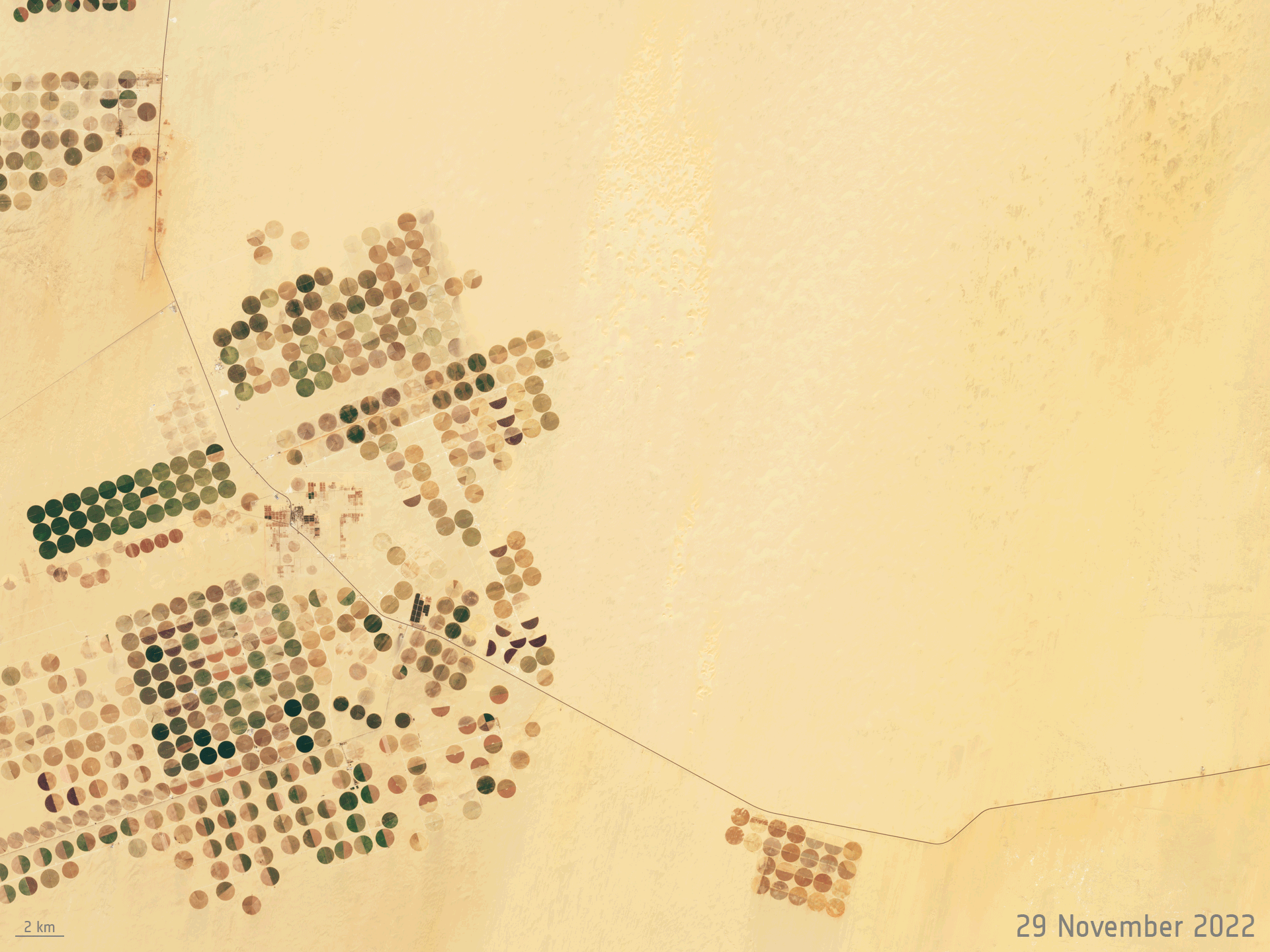
Global food security is a major challenge in the face of population growth and climate change. One of the first steps in achieving food security for all is to know which crops are growing where and how – each season. Launching today, ESA’s WorldCereal is the world’s first dynamic system capable of providing seasonally updated crop information to help monitor agricultural production across the globe.
Ice loss from Greenland and Antarctica hits new record
20.4.2023 9:00 ESA Observing the Earth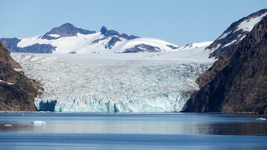
A report, released today, states that ice loss from Greenland and Antarctica has increased fivefold since the 1990s, and now accounts for a quarter of sea-level rise.
Ice loss from Greenland and Antarctica hits new record
20.4.2023 9:00 ESA Observing the Earth
A report, publishing today, states that ice loss from Greenland and Antarctica has increased fivefold since the 1990s, and now accounts for a quarter of sea-level rise.
Jarni webináře s ARCDATA PRAHA
20.4.2023 8:51 GISportal.cz
Společnost ARCDATA PRAHA připravila šest jarních webinářů, které jsou pro zájemce zdarma v termínech níže. Na jednotlivé webináře se ale musíte dopředu registrovat! Na jaká témata se můžete těšit? ArcGIS Dashboards – rozšíření pomocí Arcade (Matej Vrtich, 11. května) ArcGIS for Microsoft 365 – zaměřeno na Microsoft Excel (Radek Kuttelwascher, 18. května) ArcGIS Field Maps Designer […]
The post Jarni webináře s ARCDATA PRAHA appeared first on GISportal.cz.
Jarni webináře s ARCDATA PRAHA
20.4.2023 8:51 GISportal.czSpolečnost ARCDATA PRAHA připravila šest jarních webinářů, které jsou pro zájemce zdarma v termínech níže. Na jednotlivé webináře se ale musíte dopředu registrovat! Na jaká témata se můžete těšit? ArcGIS Dashboards – rozšíření pomocí Arcade (Matej Vrtich, 11. května) ArcGIS for Microsoft 365 – zaměřeno na Microsoft Excel (Radek Kuttelwascher, 18. května) ArcGIS Field Maps Designer […]
The post Jarni webináře s ARCDATA PRAHA appeared first on GISportal.cz.
Z knižních novinek (VI) - Střední a východní Evropa [Knihovna geografie, byTopic]
20.4.2023 0:00 Katedra aplikované geoinformatiky a kartografie Přf UK Současné tragické události na Ukrajině mají krom jiného i velmi hluboké historické kořeny. Výběr z našich novinek týkající se širšího území střední a východní Evropy vám alespoň některé z nich pomůže osvětlit. Přijďte se přesvědčit!Marc Goldman podcast conversation
19.4.2023 20:00 buildingSMART.orgMarc Goldman of Esri, discusses his election to the buildingSMART International Infrastructure Room, how BIM and GIS standards are going to reshape the future of the building and infrastructure industry,…
The post Marc Goldman podcast conversation appeared first on buildingSMART International.
How much water do we use for irrigation?
19.4.2023 16:04 ESA Observing the Earth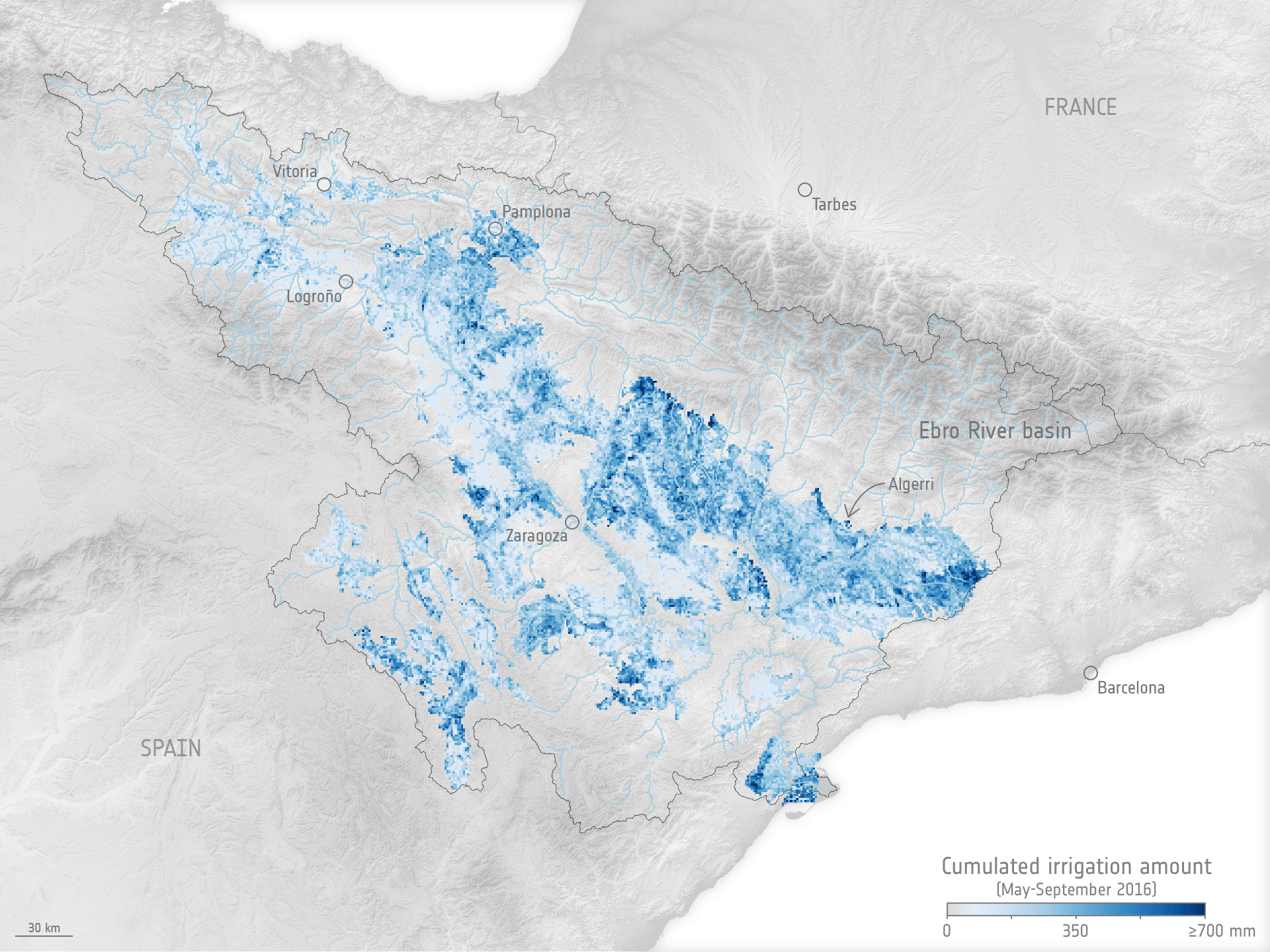
While we know that we use more water for irrigation than for any other single purpose, watering practices are not monitored worldwide. Water needed for agriculture is expected to further increase as time goes on, so managing this precious resource as effectively as possible is imperative. Scientists have now shown that a nifty way of using information from satellites could pave the way to measuring how much water we use to irrigate, which could subsequently lead to better management.
How much water do we use for irrigation?
19.4.2023 16:04 ESA Observing the Earth
While we know that we use more water for irrigation than for any other single purpose, watering practices are not monitored worldwide. Water needed for agriculture is expected to further increase as time goes on, so managing this precious resource as effectively as possible is imperative. Scientists have now shown that a nifty way of using information from satellites could pave to way to measuring how much water we use to irrigate, which could subsequently lead to better management.
10 remarkable Earth facts
18.4.2023 15:25 ESA Observing the Earth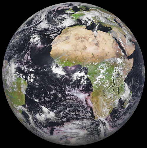
Every year on 22 April, we’ve celebrated Earth Day and the beautiful planet we call home. Earth Day, established in 1970, has been used to highlight our planet’s environmental challenges and raise awareness of the importance of protecting our world for future generations. But shouldn’t every day be Earth Day? We only have one beautiful planet after all. We hope you enjoy this curated list of 10 of the most remarkable facts about Earth.
Scroll to the end of the article to take part in ESA's Earth Day 2023 campaign.
10 remarkable Earth facts
18.4.2023 15:25 ESA Observing the Earth
Every year on 22 April, we’ve celebrated Earth Day and the beautiful planet we call home. Earth Day, established in 1970, has been used to highlight our planet’s environmental challenges and raise awareness of the importance of protecting our world for future generations. But shouldn’t every day be Earth Day? We only have one beautiful planet after all. We hope you enjoy this curated list of 10 of the most remarkable facts about Earth.
Scroll to the end of the article to take part in ESA's 'You like, we plant' campaign.