


![]()

zprávy
zdroje zpráv:TwiGIS pracuje s 3D objekty, vytvořenými v BIM softwaru
5.6.2023 17:15 GeoBusinessThe post TwiGIS pracuje s 3D objekty, vytvořenými v BIM softwaru appeared first on GeoBusiness.
Rada/odborný rada – oddělení katastrálního operátu 1
5.6.2023 16:47 ČÚZK - volná místa Katastrální úřad pro Karlovarský kraj vypisuje výběrové řízení na místo Rada/odborný rada – oddělení katastrálního operátu 1Rada/odborný rada – oddělení katastrálního operátu 1
5.6.2023 16:47 ČÚZK - předpisy a opatření Katastrální úřad pro Karlovarský krajvypisuje výběrové řízení na místo
Rada/odborný rada – oddělení katastrálního operátu 1
Rada/odborný rada – oddělení katastrálního operátu 1
5.6.2023 16:47 ČÚZK /Urady/Katastralni-urady/Katastralni-urady/Katastralni-urad-pro-Karlovarsky-kraj/Uredni-deska/Oznameni-a-jina-uredni-sdeleni/Volna-mista/DMS/Rada-odborny-rada-–-oddeleni-katastralniho-operatu20230605
5.6.2023 15:06 ČÚZK /Urady/Katastralni-urady/Katastralni-urady/Katastralni-urad-pro-Stredocesky-kraj/Katastralni-pracoviste/KP-Praha-zapad/O-uradu/Aktuality/20210412_Uprava-urednich-hodin-(1)20230605
5.6.2023 15:06 ČÚZK - předpisy a opatření Katastrální úřad pro Středočeský kraj - Katastrální pracoviště Praha-západ zveřejnil novou aktualitu: Upozorňujeme, že od 8. 6. do 20. 7. 2023 bude z důvodu výkopových prací omezeno parkování v okolí budovy zeměměřických a katastrálních úřadů v Praze. K dopravě na úřady doporučujeme využít MHD (stanice metra C Kobylisy).20230605
5.6.2023 15:04 ČÚZK - předpisy a opatření Katastrální úřad pro Středočeský kraj zveřejnil novou aktualitu: Upozorňujeme, že od 8. 6. do 20. 7. 2023 bude z důvodu výkopových prací omezeno parkování v okolí budovy zeměměřických a katastrálních úřadů v Praze. K dopravě na úřady doporučujeme využít MHD (stanice metra C Kobylisy).20230605
5.6.2023 15:04 ČÚZK /Urady/Katastralni-urady/Katastralni-urady/Katastralni-urad-pro-Stredocesky-kraj/Katastralni-pracoviste/KP-Praha-vychod/O-uradu/Aktuality/20210412_Uprava-urednich-hodin-(1)20230605
5.6.2023 15:04 ČÚZK - předpisy a opatření Katastrální úřad pro Středočeský kraj - Katastrální pracoviště Praha-východ zveřejnil novou aktualitu: Upozorňujeme, že od 8. 6. do 20. 7. 2023 bude z důvodu výkopových prací omezeno parkování v okolí budovy zeměměřických a katastrálních úřadů v Praze. K dopravě na úřady doporučujeme využít MHD (stanice metra C Kobylisy).Parkovani_budova
5.6.2023 15:00 ČÚZK - předpisy a opatření Český úřad zeměměřický a katastrální zveřejnil novou aktualitu: Upozorňujeme, že od 8. 6. do 20. 7. 2023 bude z důvodu výkopových prací omezeno parkování v okolí budovy zeměměřických a katastrálních úřadů v Praze. K dopravě na úřady doporučujeme využít MHD (stanice metra C Kobylisy).omezení parkování v okolí budovy
5.6.2023 15:00 ČÚZK - předpisy a opatření Český úřad zeměměřický a katastrální zveřejnil novou aktualitu: Upozorňujeme, že od 8. 6. do 20. 7. 2023 bude z důvodu výkopových prací omezeno parkování v okolí budovy zeměměřických a katastrálních úřadů v Praze. K dopravě na úřady doporučujeme využít MHD (stanice metra C Kobylisy).omezení parkování v okolí budovy
5.6.2023 15:00 Zeměměřický úřad Český úřad zeměměřický a katastrální zveřejnil novou aktualitu: Upozorňujeme, že od 8. 6. do 20. 7. 2023 bude z důvodu výkopových prací omezeno parkování v okolí budovy zeměměřických a katastrálních úřadů v Praze. K dopravě na úřady doporučujeme využít MHD (stanice metra C Kobylisy).omezení parkování v okolí budovy
5.6.2023 15:00 ČÚZK /Urady/Zememericky-urad/O-uradu/Aktuality/Parkovani_budovaParkovani_budova
5.6.2023 15:00 Zeměměřický úřad Český úřad zeměměřický a katastrální zveřejnil novou aktualitu: Upozorňujeme, že od 8. 6. do 20. 7. 2023 bude z důvodu výkopových prací omezeno parkování v okolí budovy zeměměřických a katastrálních úřadů v Praze. K dopravě na úřady doporučujeme využít MHD (stanice metra C Kobylisy).20230605
5.6.2023 14:57 ČÚZK /Urady/Katastralni-urady/Katastralni-urady/Katastralni-urad-pro-Stredocesky-kraj/O-uradu/Aktuality/20210412_Uprava-urednich-hodin-(1)20230605
5.6.2023 14:57 ČÚZK - předpisy a opatření Katastrální úřad pro Středočeský kraj zveřejnil novou aktualitu: Upozorňujeme, že od 8. 6. do 20. 7. 2023 bude z důvodu výkopových prací omezeno parkování v okolí budovy zeměměřických a katastrálních úřadů v Praze. K dopravě na úřady doporučujeme využít MHD (stanice metra C Kobylisy).05.06.2023
5.6.2023 14:31 ČÚZK - předpisy a opatření Katastrální úřad pro hlavní město Prahu zveřejnil novou aktualitu: Upozorňujeme, že od 8. 6. do 20. 7. 2023 bude z důvodu výkopových prací omezeno parkování v okolí budovy zeměměřických a katastrálních úřadů v Praze. K dopravě na úřady doporučujeme využít MHD (stanice metra C Kobylisy).05.06.2023
5.6.2023 14:31 ČÚZK /Urady/Katastralni-urady/Katastralni-urady/Katastralni-urad-pro-hlavni-mesto-Prahu/O-uradu/Aktuality/05-06-202320230605 - Omezení parkování
5.6.2023 12:55 ČÚZK - předpisy a opatření Český úřad zeměměřický a katastrální zveřejnil novou aktualitu: Upozorňujeme, že od 8. 6. do 20. 7. 2023 bude z důvodu výkopových prací omezeno parkování v okolí budovy zeměměřických a katastrálních úřadů v Praze. K dopravě na úřady doporučujeme využít MHD (stanice metra C Kobylisy).20230605 - Omezení parkování
5.6.2023 12:55 ČÚZK - aktuality v resortu Upozorňujeme, že od 8. 6. do 20. 7. 2023 bude z důvodu výkopových prací omezeno parkování v okolí budovy zeměměřických a katastrálních úřadů v Praze. K dopravě na úřady doporučujeme využít MHD (stanice metra C Kobylisy).20230605 - Omezení parkování
5.6.2023 12:55 ČÚZK - předpisy a opatření Český úřad zeměměřický a katastrální zveřejnil novou aktualitu: Upozorňujeme, že od 8. 6. do 20. 7. 2023 bude z důvodu výkopových prací omezeno parkování v okolí budovy zeměměřických a katastrálních úřadů v Praze. K dopravě na úřady doporučujeme využít MHD (stanice metra C Kobylisy).Ministerstvo životního prostředí společně s Českou informační agenturou životního prostředí (CENIA) představují novou webovou storymapu o životním prostředí
5.6.2023 12:30 GISportal.cz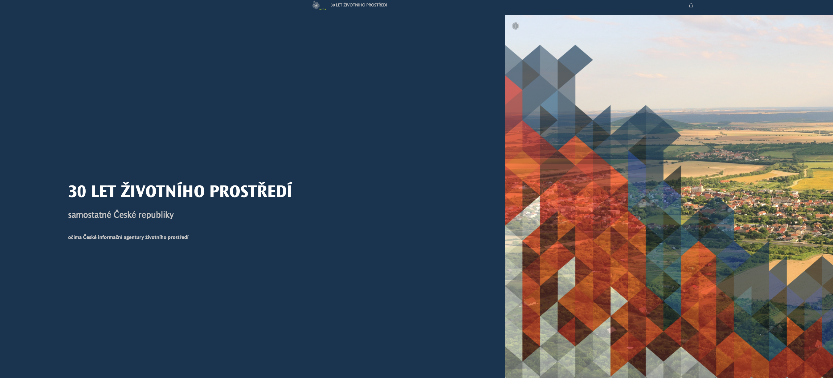
Ministerstvo životního prostředí společně s Českou informační agenturou životního prostředí (CENIA) představují novou webovou storymapu o životním prostředí, které mapuje 30 let proměn od vzniku samostatné České republiky. Webová stránka přehledně seznamuje nejen se změnami, kterými jsme prošli v minulosti, ale i s novými trendy a výzvami, kterým budeme teprve čelit. „Informace o ovzduší, lesích, […]
The post Ministerstvo životního prostředí společně s Českou informační agenturou životního prostředí (CENIA) představují novou webovou storymapu o životním prostředí appeared first on GISportal.cz.
EGNOS latest payload becomes operational ahead of V3 Service
5.6.2023 12:29 European GNSS Agency
Launched onboard EUTELSAT’s Hotbird 13G satellite in November 2022 from Cape Canaveral, the EGNOS payload is ready to transmit the first EGNOS V3 test signals, as of Thursday, 1 June 2023. Placed in a geostationary orbit some 35,000 km away from the Earth, the payload underwent a rigorous testing phase before entering service. It is expected to have a life duration of 15 years.
"With the new payload in service, the EGNOS Space segment is now fully ready for the move to the next generation, EGNOS V3" said Jean-Marc Piéplu, EGNOS Exploitation Programme Manager at EUSPA. "Our role at EUSPA is to ensure the operability and the safety of the system with the core aim to benefit end users" he concluded.
Enhanced performance and increased autonomy for Europe
The next generation of EGNOS - EGNOS V3 - will augment both GPS and Galileo in the L1 and L5 bands. It is also set to provide additional satellite-based augmentation system (SBAS) service capabilities through a new SBAS channel on L5 and will deliver increased EGNOS service availability within and beyond the EU, supporting a growing number of users.
Aviation has benefitted greatly from EGNOS, namely from the system’s Safety of Life service. This has enabled better access to small and regional airports, increased safety and facilitated more sustainable flight routes across Europe.
Other transport means including maritime and rail also benefit from the EGNOS Safety of Life service. Thanks to its Open Service, EGNOS also increases the positioning accuracy for other land-based applications, notably precision farming, geomatics, and land management.
Read this: Are all signals the same?
In addition to the improved user experience, the new EGNOS payload is another reaffirmation of the Union’s investment in advanced space technologies. Together with the EGNOS GEO-5 and with the deployment of the next generation Galileo satellites, Europe further increases its autonomous access to space.
About EGNOS
EGNOS is Europe's regional satellite-based augmentation system (SBAS). It is currently used to improve the performance of GPS and will augment Galileo from 2025 onwards. EGNOS was deployed to provide safety of life navigation services to aviation, maritime and land-based users.
EGNOS uses GNSS measurements taken by reference stations deployed mainly across Europe and North Africa. These measurements are transferred to a central computing centre where differential corrections and integrity messages are calculated. These calculations are then broadcast over the covered area using geostationary satellites that serve as an augmentation, or overlay, to the original GNSS message.
The information provided by EGNOS improves the accuracy and reliability of GNSS positioning information while also providing a crucial integrity message. In addition, EGNOS also transmits an accurate time signal.
Media note: This feature can be republished without charge provided the European Union Agency for the Space Programme (EUSPA) is acknowledged as the source at the top or the bottom of the story. You must request permission before you use any of the photographs on the site. If you republish, we would be grateful if you could link back to the EUSPA website (http://www.euspa.europa.eu).
Aktualizováno: Pozvánka na virtuální setkání ÚOZI 7.6.2023
5.6.2023 10:24 ZeměměřičOd 1. července 2023 vzniká zeměměřická komora ze zákona. Zákonná ustanovení jsou již známá a vyplývá z nich mnoho zajímavých informací, o kterých bychom jako zeměměřiči měli vědět. Asociace podnikatelů v geomatice (APG) dokázala svou heroickou snahou a úsilím zeměměřickou komoru vybudovat, tedy zajistit potřebnou shodu napříč politickými stranami, u ministerstev, jiných profesních komor a předložit – po spolupráci řady stran – odpovídající změnu […]
The post Aktualizováno: Pozvánka na virtuální setkání ÚOZI 7.6.2023 appeared first on Zeměměřič.
Uverejnili na ŽIVÉ.SK
5.6.2023 8:41
ÚGKK SR
Slovensko má nové 3D modely povrchu krajiny, sú pre každého zadarmo
výběrové řízení na KP Pelhřimov
5.6.2023 6:48 ČÚZK - předpisy a opatření Katastrální úřad pro Vysočinu - Katastrální pracoviště Pelhřimov zveřejnil novou aktualitu: Oznámení o vyhlášení výběrového řízení na služební místo rada/odborný rada – vedoucí oddělení aktualizace KN Katastrálního pracoviště Pelhřimov na Katastrálním úřadu pro Vysočinu.DAEX DESIGN Start pro truhláře a nábytkáře v akci do 31. 5. 2023
2.6.2023 19:01 ŠPINAR - softwareVážení zákazníci, připravili jsme pro Vás DAEX DESIGN Start pro výrobce a návrháře nábytku a interiérů s rozšiřujícími bonusy do 31. 5. 2023
The post DAEX DESIGN Start pro truhláře a nábytkáře v akci do 31. 5. 2023 appeared first on ŠPINAR – software.
TurboCAD Pro MAC CZ v akční ceně do 11. 6. 2023
2.6.2023 19:01 ŠPINAR - softwareVážení zákazníci, připravili jsme pro Vás TurboCAD Pro MAC v akční ceně do 11. 6. 2023
The post TurboCAD Pro MAC CZ v akční ceně do 11. 6. 2023 appeared first on ŠPINAR – software.
Odborný referent v oddělení obnovy katastrálního operátu č.1 na Technické sekci
2.6.2023 11:47 ČÚZK - předpisy a opatření Katastrální úřad pro Jihomoravský kraj technická sekcevypisuje výběrové řízení na místo
Odborný referent v oddělení obnovy katastrálního operátu č.1 na Technické sekci
Odborný referent v oddělení obnovy katastrálního operátu č.1 na Technické sekci
2.6.2023 11:47 ČÚZK - volná místa Katastrální úřad pro Jihomoravský kraj technická sekce vypisuje výběrové řízení na místo Odborný referent v oddělení obnovy katastrálního operátu č.1 na Technické sekciOdborný referent v oddělení obnovy katastrálního operátu č.1 na Technické sekci
2.6.2023 11:47 ČÚZK /Urady/Katastralni-urady/Katastralni-urady/Katastralni-urad-pro-Jihomoravsky-kraj/Uredni-deska/Oznameni-a-jina-uredni-sdeleni/Volna-mista/DMS/Odborny-referent-v-oddeleni-obnovy-katastralni-(2)rada-odborný rada - vedoucí oddělení aktualizace KN - KP Pelhřimov
2.6.2023 10:06 ČÚZK /Urady/Katastralni-urady/Katastralni-urady/Katastralni-urad-pro-Vysocinu/Uredni-deska/Oznameni-a-jina-uredni-sdeleni/Volna-mista/DMS/rada-odborny-rada-vedouci-oddeleni-aktualizace-KN-rada-odborný rada - vedoucí oddělení aktualizace KN - KP Pelhřimov
2.6.2023 10:06 ČÚZK - volná místa Katastrální úřad pro Vysočinu Katastrální pracoviště Pelhřimov vypisuje výběrové řízení na místo rada-odborný rada - vedoucí oddělení aktualizace KN - KP Pelhřimovrada-odborný rada - vedoucí oddělení aktualizace KN - KP Pelhřimov
2.6.2023 10:06 ČÚZK - předpisy a opatření Katastrální úřad pro Vysočinu Katastrální pracoviště Pelhřimovvypisuje výběrové řízení na místo
rada-odborný rada - vedoucí oddělení aktualizace KN - KP Pelhřimov
Earth from Space: Anchorage, Alaska
2.6.2023 10:00 ESA Observing the Earth Image:
From the Chugach Mountains on the right to the Cook Inlet on the left, this Copernicus Sentinel-2 image features the varied landscape surrounding Anchorage, the largest and most populous city in the state of Alaska in the United States.
Image:
From the Chugach Mountains on the right to the Cook Inlet on the left, this Copernicus Sentinel-2 image features the varied landscape surrounding Anchorage, the largest and most populous city in the state of Alaska in the United States.
Omezení provozu kontaktního místa v Bystřici nad Pernštejnem
2.6.2023 9:03 ČÚZK - předpisy a opatření Český úřad zeměměřický a katastrální - Katastrální pracoviště Žďár nad Sázavou zveřejnil novou aktualitu: Katastrální úřad pro Vysočinu, Katastrální pracoviště Žďár nad Sázavou oznamuje, že od 19. 6. 2023 do 31. 7. 2023 bude Kontaktní místo Bystřice nad Pernštejnem z provozních důvodů uzavřeno.V případě potřeby se obracejte na podatelnu Katastrálního pracoviště Žďár nad Sázavou, se sídlem Strojírenská 8, 591 27 Žďár nad Sázavou.
Děkujeme za pochopení.
Omezení provozu kontaktního místa v Bystřici nad Pernštejnem
2.6.2023 9:03 ČÚZK - předpisy a opatření Katastrální úřad pro Vysočinu - Katastrální pracoviště Žďár nad Sázavou zveřejnil novou aktualitu: Katastrální úřad pro Vysočinu, Katastrální pracoviště Žďár nad Sázavou oznamuje, že od 19. 6. 2023 do 31. 7. 2023 bude Kontaktní místo Bystřice nad Pernštejnem z provozních důvodů uzavřeno.V případě potřeby se obracejte na podatelnu Katastrálního pracoviště Žďár nad Sázavou, se sídlem Strojírenská 8, 591 27 Žďár nad Sázavou.
Děkujeme za pochopení.
Mapy jsou pro každého 2023 (pozvánka)
2.6.2023 8:13 GISportal.cz
Organizátoři konference si Vás dovolují pozvat na letošní 9. ročník konference Mapy jsou pro každého (hotel Luna 12. – 13. září 2023). Můžete se těšit na zajímavé příspěvky a inspirativní setkání k tématům, která v každodenní práci řešíte. Nezapomeneme se ohlédnout za projekty digitálních technických map a mrkneme také na to, co nás dále čeká. […]
The post Mapy jsou pro každého 2023 (pozvánka) appeared first on GISportal.cz.
Mapy jsou pro každého 2023 (pozvánka)
2.6.2023 8:13 GISportal.czOrganizátoři konference si Vás dovolují pozvat na letošní 9. ročník konference Mapy jsou pro každého (hotel Luna 12. – 13. září 2023). Můžete se těšit na zajímavé příspěvky a inspirativní setkání k tématům, která v každodenní práci řešíte. Nezapomeneme se ohlédnout za projekty digitálních technických map a mrkneme také na to, co nás dále čeká. […]
The post Mapy jsou pro každého 2023 (pozvánka) appeared first on GISportal.cz.
28. jednání KRS
1.6.2023 16:39 ČÚZK - předpisy a opatření Dne 28. června 2023 proběhne distančně 28. jednání Koordinační rady správců DMVS a DTM.10. jednání TPS
1.6.2023 16:37 ČÚZK - předpisy a opatření Dne 21. června 2023 proběhne distančně 10. jednání Technické pracovní skupiny Koordinační rady správců DMVS a DTM.Nová verze JVF DTM 1.4.2.3
1.6.2023 16:32 ČÚZK - předpisy a opatření Do záložky JVF DTM byla přidána dokumentace k nové verzi JVF DTM 1.4.2.3. Tato verze byla vydána s ohledem na nutnost validního uložení neveřejných informací veřejných objektových typů a dne 31. května 2023 byla schválena Koordinační radou správců DMVS a DTM. S jejím nasazením na produkční prostředí se počítá, stejně jako s avizovanými změnami ve verzi JVF DTM 1.4.2.2, v termínu od 1. července 2023.Osvěta od Geodézie Plch pro středoškoláky oboru stavebnictví a pozemní stavitelství
1.6.2023 16:29 ZeměměřičFirma Geodézie Plch se snaží mezi studenty zvýšit povědomí o možnostech geodézie a věří, že také díky jejich snaze bude obor geodézie zajímavějším pro studenty, kteří se rozhodují o svém dalším směřování. Přednáška Přemysla Plcha se uskutečnila 18. dubna 2023 na Masarykově střední škole Letovice. Ing. Plch studentům oboru Stavebnictví – pozemní stavitelství vysvětlil, jako vypadá moderní geodézie – […]
The post Osvěta od Geodézie Plch pro středoškoláky oboru stavebnictví a pozemní stavitelství appeared first on Zeměměřič.
ČSGK zve na akci o novele zeměměřického zákona
1.6.2023 16:18 ZeměměřičČeský svaz geodetů a kartografů zve na odbornou akci, nazvanou „Novela zeměměřického zákona, vznik České komory zeměměřičů (ČKZ)“. Akce se koná ve středu 14. června 2023 v kongresovém sále č. 217 v Praze 1, Novotného lávka 5. Program 9:30 – 9:35 Zahájení a úvodní slovo 9:35 – 10:15 Snahy o vznik komory zeměměřičů v minulosti a současná situace – Ing. Karel Večeře, ČÚZK 10:15 […]
The post ČSGK zve na akci o novele zeměměřického zákona appeared first on Zeměměřič.
ČSGK zve na akci o novele zeměměřického zákona
1.6.2023 16:18 ZeměměřičČeský svaz geodetů a kartografů zve na odbornou akci, nazvanou „Novela zeměměřického zákona, vznik České komory zeměměřičů (ČKZ)“. Akce se koná ve středu 14. června 2023 v kongresovém sále č. 217 v Praze 1, Novotného lávka 5. Program 9:30 – 9:35 Zahájení a úvodní slovo 9:35 – 10:15 Snahy o vznik komory zeměměřičů v minulosti a současná situace – Ing. Karel Večeře, ČÚZK 3. 10:15 […]
The post ČSGK zve na akci o novele zeměměřického zákona appeared first on Zeměměřič.
Aliance vystavovala na Dni dětí na Ministerstvu dopravy a prezident Aliance mluvil s ministrem dopravy
1.6.2023 15:49 UAVADnes najdete UAVA společně s Létejte zodpovědně na Dni dětí na Ministerstvu dopravy, kde ukazujeme drony a jaká jsou pravidla jejich provozu. Kromě toho prezident Aliance mluvil s ministrem dopravy Martinem Kupkou k urychlení implementace U-space, který to uvedl jako jednu ze svých priorit.
The post Aliance vystavovala na Dni dětí na Ministerstvu dopravy a prezident Aliance mluvil s ministrem dopravy appeared first on UAV Aliance pro bezpilotní letecký průmysl.
CubeMAP mission development halted
1.6.2023 14:00 ESA Observing the Earth
After very careful consideration, ESA’s Earth Observation Programme Board has taken the decision to terminate the development of CubeMAP as a Scout satellite mission. This decision is based on the development path exceeding the programmatic constraints related to the timeline and budgetary boundaries allocated for this category of New Space mission.
Gefos pořádá BLK Day, věnovaný skenování a zpracování dat
1.6.2023 12:49 ZeměměřičSpolečnost Gefos, autorizovaný prodejce techniky Leica Geosystems, zve na jednodenní konferenci BLK Day, která se bude konat 15. června v hotelu Tři Věžičky ve Stříteži u Jihlavy. K vidění a vyzkoušení budou nové statické, mobilní i létající skenery řady BLK (např. BLK360, BLK2GO, BLK2FLY, nebo BLK ARC) a navazující software pro zpracování dat. Pořadatelé se po stručných prezentacích budou věnovat praktickému měření a zpracování […]
The post Gefos pořádá BLK Day, věnovaný skenování a zpracování dat appeared first on Zeměměřič.
Setkání zeměměřičů Plzeňského a Karlovarského kraje
1.6.2023 12:14 ZeměměřičAsociace podnikatelů v geomatice (APG) zve na Setkání zeměměřičů Plzeňského a Karlovarského kraje. Setkání se uskuteční v pondělí 19. června 2023 od 9:15 v areálu Fakulty aplikovaných věd Západočeské univerzity v Plzni (Technická 8, Plzeň 3, budova NTIS, posluchárna UN207). Prezence: od 9:00, předpokládané ukončení ve 13 hod. Program setkání 9:00 – 9:15 – Prezence 9:15 – 10:45 – Blok I […]
The post Setkání zeměměřičů Plzeňského a Karlovarského kraje appeared first on Zeměměřič.
How EU Space supports Europe’s environmental policies
1.6.2023 11:48 European GNSS Agency
A famous frog once sang, ‘it’s not easy being green’.
Clearly, he didn’t know about EU Space.
“With the wealth of data, services and information that the EU Space Programme provides, ‘being green’ has become a whole lot easier,” says EUSPA Executive Director Rodrigo da Costa.
As Europe prepares to celebrate EU Green Week from 3 – 11 June, let’s look at some of the ways EU Space supports the package of policies and initiatives that is the European Green Deal – Europe’s roadmap to becoming the world’s first climate neutral continent.
Energy Performance of Buildings Directive
Our homes, offices, schools, hospitals, libraries, and other buildings are, collectively, the single largest consumer of energy. They’re also one of the largest emitters of carbon dioxide, responsible for 36% of all greenhouse gas emissions.
In other words, the path to climate neutrality starts with energy efficient buildings.
Here, the Copernicus Atmosphere Monitoring Service helps monitor emissions in residential areas of cities. With this information in hand, urban planners can focus on renovating the worst-performing buildings first.
Last year, EUSPA also kicked-off a series of Horizon Europe projects that aim to support the transversal objectives of the European Green Deal. Among these projects, BUILDSPACE aims to enable greener and more sustainable management of buildings and urban areas in European cities, using Digital Twins powered by EU Space data. The city services of Piraeus, Riga and Ljubljana are expected to validate the digital twin services delivered by the project.
Renewable Energy Directive / RePowerEU
Today, approximately 22% of the EU’s energy comes from renewable sources. These initiatives seek to not only more than double this, but to do so in just a few years’ time.
Unfortunately, we don’t have a ‘magic switch’ that we can flip to go from our current fossil fuel- based energy system to one based on renewables. But what we do have is EU Space. A recently initiated EUSPA project called RESPONDENT uses Galileo timing and synchronization services to allow for smarter grid monitoring, improved power balancing and overall better operation of the infrastructure of renewable energy sources.
From choosing the best location for wind turbines to understanding how dust storms might impact solar energy production, the EU Space Programme will be a key enabler of Europe’s energy transition.
Corporate Sustainability Reporting Directive
Large listed businesses, banks and insurance companies with over 500 employees are required to reports on their Environment-Social-Government (ESG) policies and performance. To do so, many are turning to Earth Observation.
High-quality, objective, independent, verifiable, regularly updated, comprehensive, global – these are all reasons why Earth Observation data is so well-suited for environmental risk assessment and monitoring. Furthermore, Earth Observation has the benefit of allowing users to quickly and cost-effectively collect and analyse large amounts of information over a large spatial extent in a consistent, unbiased, repetitive and cost-effective manner.
Regulation on Land Use, Land Use Change & Forestry
Both Galileo and Copernicus play a role in preventing illegal logging. By flagging potential development and road construction happening within forests, Earth Observation data helps authorities look for illegal activity and predict where such activity is most likely to occur. Authorities can also leverage the precise positioning provided by Galileo to track timbre movements, which increases the transparency and traceability of the timber supply chain and reduces the likelihood that illegal exportation goes unnoticed.
Carbon Offset and Reduction Scheme for International Aviation
Once an airline’s collective emissions surpass 2019 levels, CORSIA requires them to offset all additional carbon emissions. But instead of just paying to offset, airlines are also working to reduce their carbon footprint. For example, using Galileo, airlines and airports can improve their ground operations, saving fuel and thus cutting greenhouse gas emissions.
EGNOS also helps make flights more sustainable. On the one hand, EGNOS allows for a smooth, continuous glide path approach that is significantly more fuel efficient. On the other hand, the lower decision height that EGNOS enables can help pilots better evaluate visibility conditions, which in many cases means avoiding the need to circle or divert – two manoeuvres that burn a lot of fuel.
Supporting companies’ green transformations
While each of the above listed initiatives are essential to achieving Europe’s ambitious climate change goals, policy without action amounts to nothing more than empty promises. In fact, each of these goals requires that companies take a deep look at their internal operations, as well as their supply chains, to identify opportunities for reducing their own environmental footprints.
Here too EU Space plays a role.
While the EU Space Programme and the data and services it provides are important assets to supporting the implementation of the Green Deal, businesses stand to benefit too. For example, Copernicus, Galileo and EGNOS supply the information companies need to monitor environmental indicators, reduce their environmental impact, comply with relevant policies and regulations, become more sustainable and drive the green transformations. Better yet, much of this data is openly accessibly and provided free of charge.
To help companies utilise this data as a means of driving their own sustainability journeys, EUSPA has published its first EU Space for the Green Transformation report. The practical guide is full of best practices and real-world examples on how EU Space can make being green easier for companies of all shapes, sizes and sectors.
“If this report is a trusted roadmap for a green transformation and sustainability journey for companies willing to evolve towards a sustainable future, EUSPA's work on Horizon Europe also creates new opportunities for businesses and reinforces the Union's green ambition. Together, we can drive positive change and seize the benefits of sustainable practices, " concludes da Costa.
You can download your free copy of the EU Space for the Green Transformation report here.
Media note: This feature can be republished without charge provided the European Union Agency for the Space Programme (EUSPA) is acknowledged as the source at the top or the bottom of the story. You must request permission before you use any of the photographs on the site. If you republish, we would be grateful if you could link back to the EUSPA website (http://www.euspa.europa.eu).
Accelerating the Green Transition
1.6.2023 10:30 ESA Observing the Earth
Earth observation has been essential in identifying and monitoring climate change. Satellite data form the baseline for effective European mitigation and adaptation strategies to support the Green Transition, the European Union to reach its goal of becoming carbon neutral by 2050, as well as its Green Deal.
ESA has now concluded its initial phase of a pilot initiative in Austria that demonstrates the untapped potential of space technologies by providing actionable Earth observation information to accelerate the Green Transition for both society and the economy.
Accelerating the Green Transition
1.6.2023 10:30 ESA Observing the Earth
Earth observation has been essential in identifying and monitoring climate change. Satellite data form the baseline for effective European mitigation and adaptation strategies to support the Green Transition, the European Union's Green Deal and the global goal of becoming carbon neutral by 2050.
ESA has now concluded its initial phase of a pilot initiative in Austria that demonstrates the untapped potential of space technologies by providing actionable Earth observation information to accelerate the Green Transition for both society and the economy.
Galileo Second Generation enters full development phase
1.6.2023 9:35 ESA Navigation
Update July 2023:
Three more contracts for Galileo’s Second Generation development have been signed by ESA, on behalf of EUSPA, with respectively GMV (Spain) for the Ground Control Segment, Thales (France) for Security Monitoring and Thales Alenia Space (France) on the Ground Mission Segment. In total, an amount of approximately €900 million has been awarded since summer 2022 which will lead forward the development of Galileo’s Second Generation to provide more robust, resilient, and new services in the near future for users worldwide.
Galileo Second Generation enters full development phase
1.6.2023 9:35 ESA Navigation
The main procurements batch of Galileo Second Generation initiated last summer has been finalised, leaving the system ready for its In Orbit Validation development phase. Today, following the opening session of the European Navigation Conference (ENC), ESA Director of Navigation Javier Benedicto invited Thales (Italy), Airbus Defence and Space (Germany) and Thales Six GTS (France) to sign the respective contracts commencing System Engineering Support for the next generation of Europe’s navigation satellite system.
Včelaření v době klimatické změny (mapová publikace)
1.6.2023 8:48 GISportal.cz
Ve spolupráci geoinformatiků a biochemiků z Přírodovědecké fakulty Univerzity Palackého v Olomouc vznikla zajímavá mapová publikace „Včelaření v době klimatické změny“. Na tomto odkazu si můžete zdarma stáhnout první mapovou publikaci, která formou map popisuje změny ve včelařském sektoru za několik posledních let. Jedná o první publikaci svého druhu, která vychází z dat dostupných pro […]
The post Včelaření v době klimatické změny (mapová publikace) appeared first on GISportal.cz.
ARKANCE zíkává firmu VinZero a zdvojnásobuje svou velikost
1.6.2023 8:00 Arkance SystemsVýznamná akvizice mezinárodní společnosti VinZero, která se specializuje na digitální transformaci pro stavebnictví a strojírenství.
Zpráva ARKANCE zíkává firmu VinZero a zdvojnásobuje svou velikost pochází z arkance-systems.cz.
ARKANCE získává firmu VinZero a zdvojnásobuje svou velikost
1.6.2023 8:00 Arkance SystemsVýznamná akvizice mezinárodní společnosti VinZero, která se specializuje na digitální transformaci pro stavebnictví a strojírenství.
Zpráva ARKANCE získává firmu VinZero a zdvojnásobuje svou velikost pochází z arkance-systems.cz.
Červnový den s CAD technikem – bezplatná online konzultace pro vaši firmu
1.6.2023 7:30 Arkance Systems23. června 2023 - přihlaste se na nový termín akce společnosti Arkance Systems. Těšíme se na vás.
Zpráva Červnový den s CAD technikem – bezplatná online konzultace pro vaši firmu pochází z arkance-systems.cz.
Červnový den s CAD technikem – bezplatná online konzultace pro vaši firmu
1.6.2023 7:30 Arkance Systems22. června 2023 - přihlaste se na nový termín akce společnosti Arkance Systems. Těšíme se na vás.
Zpráva Červnový den s CAD technikem – bezplatná online konzultace pro vaši firmu pochází z arkance-systems.cz.
Výběrové řízení na pozici odborný referent v oddělení právních vztahů k nemovitostem Katastrálního p
1.6.2023 7:09 ČÚZK - předpisy a opatření Katastrální úřad pro Královéhradecký kraj Katastrální pracoviště Rychnov nad Kněžnouvypisuje výběrové řízení na místo
Výběrové řízení na pozici odborný referent v oddělení právních vztahů k nemovitostem Katastrálního pracoviště Rychnov nad Kněžnou
Výběrové řízení na pozici odborný referent v oddělení právních vztahů k nemovitostem Katastrálního p
1.6.2023 7:09 ČÚZK - volná místa Katastrální úřad pro Královéhradecký kraj Katastrální pracoviště Rychnov nad Kněžnou vypisuje výběrové řízení na místo Výběrové řízení na pozici odborný referent v oddělení právních vztahů k nemovitostem Katastrálního pAPGEO - SPŠ stavební Brno novým přidruženým členem APG
1.6.2023 2:00 Asociace podnikatelů v geomatice V květnu se novým přidruženým členem stala Střední průmyslová škola stavební Brno.Trimble X9, nový statický skenovací systém, navazuje na model X7
31.5.2023 20:13 ZeměměřičSpolečnost Trimble představila 3D laserový skenovací systém Trimble X9. Nový model Trimble X9 rozšiřuje model Trimble X7 a přináší větší dosah, vyšší přesnost, kratší dobu skenování a vyšší citlivost, což má zlepšovat výsledky skenování Díky výkonnějšímu laseru se má zvýšit citlivost všech skenů, čímž model X9 umí zpracovat i doposud obtížné tmavé nebo reflexní povrchy. Nová konstrukce středové […]
The post Trimble X9, nový statický skenovací systém, navazuje na model X7 appeared first on Zeměměřič.
Galileo Second Generation enters full development phase
31.5.2023 14:35 ESA Navigation
The main procurements batch of Galileo Second Generation initiated last summer has been finalised, leaving the system ready for its In Orbit Validation development phase. Today, following the opening session of the European Navigation Conference (ENC), ESA Director of Navigation Javier Benedicto invited Thales Alenia Space (Italy), Airbus Defence and Space (Germany) and Thales Six GTS (France) to sign the respective contracts commencing System Engineering Support for the next generation of Europe’s navigation satellite system.
Nový GIS ve společnosti ČEVAK
31.5.2023 14:08 blog ARCDATA Přechod na novou technologii je vždy náročný projekt, a to zejména u komplexních systémů. V tomto článku se dozvíte, jak společnost ČEVAK a.s. převedla svůj GIS na systém ArcGIS, a zjistíte, jaké výhody to přineslo – od pohodlnější práce zaměstnanců po lepší informovanost zákazníků.New site in Greenland to enhance Galileo SAR
31.5.2023 10:47 European GNSS Agency
On May 17, 2023, the European Union Agency for the Space Programme (EUSPA) and Naviair, signed a cooperation agreement aimed at strengthening the monitoring capabilities of the Galileo Search and Rescue (SAR) Service by establishing a new site in Greenland. This collaboration marks a significant step towards ensuring the redundancy, of the SAR/Galileo system and therefore the safety and security of the European Union and its surrounding regions.
EUSPA, as the user-oriented operational agency of the EU Space Programme, is dedicated to promoting sustainable growth, security, and safety within the European Union. Naviair, a company owned by the Danish state and represented by the Ministry of Transport, specializes in air navigation and related infrastructure services.
The SAR/Galileo component of the EU Space Programme plays a crucial role in the detection of emergency signals transmitted by distress beacons in support of the internationally recognized Search and Rescue (SAR) Cospas-Sarsat programme. As part of this programme, the Galileo SAR Service utilises SAR instruments onboard Galileo satellites, Medium Earth Orbit Local User Terminals (MEOLUTs), and a network of SAR Reference Beacons (REFBE) located across Europe.
Recognizing the need to strengthen SAR Service monitoring capabilities, particularly around the edges of the European area, EUSPA and Naviair have joined hands to extend the ground segment and the current capabilities. As part of the agreement, Naviair will contribute to the Galileo Programme objectives by procuring, deploying, hosting, and operating a REFBE nearby the Kangerlussuaq airport in Greenland. This initiative will play a pivotal role in supporting SAR Service monitoring in cooperation with EUSPA.

SAR Reference Beacons in European Coverage Area and Indian Coverage Area
Rodrigo da Costa, Executive Director of EUSPA, highlighted that “Naviair's commitment aligns perfectly with the goals of EUSPA to constantly strengthen and advance the capabilities and services provided ensuring the safety and security of individuals within the European Union and beyond.”
Mads Kvist Eriksen, Chief Executive Officer of Naviair, expressed his enthusiasm about this collaboration, stating, "Naviair is looking forward to hosting a SAR/Galileo Reference Beacon in Kangerlussuaq, Greenland, to support SAR Service monitoring capabilities around the edges of the European area in cooperation with EUSPA."
In addition, the cooperation agreement between EUSPA and Naviair sets a precedent for future partnerships, clearly exemplifying the spirit of international cooperation that drive the Search and Rescue efforts worldwide.
The new SAR/Galileo Site and REFBE will be strategically located around the margins of the declared Service Coverage Area (see Figure 2) and will be fully integrated to SAR Ground Segment, raising the number of REFBEs to total of eight. The REFBEs provide data for service performance monitoring and there are currently five in the European Coverage Area and two in the Indian Ocean Coverage Area.
The REFBEs are fitted with vertical linear polarized antenna that transmit timely synchronised signals equivalent to a standard 406 MHz Cospas-Sarsat beacon which combined to their well-known position enables specific SAR/Galileo Service performance indicators to be derived.
The new site is bound to be ready by the fourth quarter of 2023.
Media note: This feature can be republished without charge provided the European Union Agency for the Space Programme (EUSPA) is acknowledged as the source at the top or the bottom of the story. You must request permission before you use any of the photographs on the site. If you republish, we would be grateful if you could link back to the EUSPA website (http://www.euspa.europa.eu).
Krátka správa č. 25/2023
31.5.2023 9:24 Komora geodetů a kartografů SRThe post Krátka správa č. 25/2023 appeared first on Komora geodetov a kartografov.
Register for ESA’s first Earth observation commercialisation event
31.5.2023 8:55 ESA Observing the Earth
Registration is now open for ESA’s first-ever Earth Observation Commercialisation Forum. Taking place at ESA Headquarters in Paris from 30 to 31 October 2023, investors, institutions, entrepreneurs and companies of any size from the Earth observation sector will now be able to come together and discuss the commercial potential and challenges of Earth observation, together with the technical, industrial and risk-capital support available to European companies.
APGEO - Pozvánka na Setkání zeměměřičů Plzeňského a Karlovarského kraje
31.5.2023 2:00 Asociace podnikatelů v geomatice Pozvánka na Setkání zeměměřičů Plzeňského a Karlovarského kraje, které se uskuteční 19. června 2023 v Plzni.TOSHULIN využívá generativní navrhování v Autodesk Fusion 360
30.5.2023 14:10 Arkance SystemsGenerativní design a další nové technologie pro navrhování a optimalizaci strojních součástí.
Zpráva TOSHULIN využívá generativní navrhování v Autodesk Fusion 360 pochází z arkance-systems.cz.
Oznámení o vyhlášení VŘ na služební místo rada-odborný rada
30.5.2023 13:17 ČÚZK /Urady/Zememericke-a-katastralni-inspektoraty/Zememericke-a-katastralni-inspektoraty/Zememericky-a-katastralni-inspektorat-v-Praze/O-uradu/Aktuality/Oznameni-o-vyhlaseni-VR-na-sluzebni-misto-rada-odbOznámení o vyhlášení VŘ na služební místo rada-odborný rada
30.5.2023 13:17 ČÚZK - předpisy a opatření Zeměměřický a katastrální inspektorát v Praze zveřejnil novou aktualitu: Zeměměřický a katastrální inspektorát v Praze vyhlašuje výběrové řízení na služební místo Rada/Odborný rada inspektor (obor služby 55)Rada/odborný rada - inspektor ZKI v Praze (obor služby 55.)
30.5.2023 13:12 ČÚZK /Urady/Zememericke-a-katastralni-inspektoraty/Zememericke-a-katastralni-inspektoraty/Zememericky-a-katastralni-inspektorat-v-Praze/Uredni-deska/Oznameni-a-jina-uredni-sdeleni/Volna-mista/DMS/Rada-odborny-rada-inspektor-ZKI-v-Praze-(obor-sluzRada/odborný rada - inspektor ZKI v Praze (obor služby 55.)
30.5.2023 13:12 ČÚZK - volná místa Zeměměřický a katastrální inspektorát v Praze vypisuje výběrové řízení na místo Rada/odborný rada - inspektor ZKI v Praze (obor služby 55.)Rada/odborný rada - inspektor ZKI v Praze (obor služby 55.)
30.5.2023 13:12 ČÚZK - předpisy a opatření Zeměměřický a katastrální inspektorát v Prazevypisuje výběrové řízení na místo
Rada/odborný rada - inspektor ZKI v Praze (obor služby 55.)
20230530_Vrchní referent / rada oddělení aktualizace GI KN Katastrálního
30.5.2023 11:20 ČÚZK /Urady/Katastralni-urady/Katastralni-urady/Katastralni-urad-pro-Stredocesky-kraj/Katastralni-pracoviste/KP-Praha-vychod/O-uradu/Aktuality/20210922_Odborny-referent-oddeleni-aktualizace-(1)20230530_Vrchní referent / rada oddělení aktualizace GI KN Katastrálního
30.5.2023 11:20 ČÚZK - předpisy a opatření Katastrální úřad pro Středočeský kraj - Katastrální pracoviště Praha-východ Vyhlášení výběrového řízení: Vrchní referent / rada oddělení aktualizace GI KN Katastrálního V části "Úřední deska", v sekci "Oznámení a jiná úřední sdělení" bylo vystaveno "Oznámení o vyhlášení výběrového řízení na obsazení služebního místa Vrchní referent / rada oddělení aktualizace GI KN Katastrálního"Vrchní referent / rada oddělení aktualizace GI KN Katastrálního
30.5.2023 11:18 ČÚZK /Urady/Katastralni-urady/Katastralni-urady/Katastralni-urad-pro-Stredocesky-kraj/Uredni-deska/Oznameni-a-jina-uredni-sdeleni/Volna-mista/DMS/Vrchni-referent-rada-oddeleni-aktualizace-GI-KN-KaVrchní referent / rada oddělení aktualizace GI KN Katastrálního
30.5.2023 11:18 ČÚZK - volná místa Katastrální úřad pro Středočeský kraj Katastrální pracoviště Praha-východ vypisuje výběrové řízení na místo Vrchní referent / rada oddělení aktualizace GI KN KatastrálníhoVrchní referent / rada oddělení aktualizace GI KN Katastrálního
30.5.2023 11:18 ČÚZK - předpisy a opatření Katastrální úřad pro Středočeský kraj Katastrální pracoviště Praha-východvypisuje výběrové řízení na místo
Vrchní referent / rada oddělení aktualizace GI KN Katastrálního
Aktualizováno: Pozvánka na virtuální setkání ÚOZI
30.5.2023 10:24 ZeměměřičOd 1. července 2023 vzniká zeměměřická komora ze zákona. Zákonná ustanovení jsou již známá a vyplývá z nich mnoho zajímavých informací, o kterých bychom jako zeměměřiči měli vědět. Asociace podnikatelů v geomatice (APG) dokázala svou heroickou snahou a úsilím zeměměřickou komoru vybudovat, tedy zajistit potřebnou shodu napříč politickými stranami, u ministerstev, jiných profesních komor a předložit – po spolupráci řady stran – odpovídající změnu […]
The post Aktualizováno: Pozvánka na virtuální setkání ÚOZI appeared first on Zeměměřič.
Výběrové řízení - rada/odborný rada - inspektor na ZKI Brno
30.5.2023 9:34 ČÚZK /Urady/Zememericke-a-katastralni-inspektoraty/Zememericke-a-katastralni-inspektoraty/Zememericky-a-katastralni-inspektorat-v-Brne/O-uradu/Aktuality/Vyberove-rizeni-rada-odborny-rada-inspektor-na-ZKIVýběrové řízení - rada/odborný rada - inspektor na ZKI Brno
30.5.2023 9:34 ČÚZK - předpisy a opatření Zeměměřický a katastrální inspektorát v Brně zveřejnil novou aktualitu: Oznámení o vyhlášení výběrového řízení na služební místo rada/odborný rada – inspektor Zeměměřického a katastrálního inspektorátu v Brně20230530_Rada / odborný rada oddělení aktualizace a dokumentace KN
30.5.2023 9:17 ČÚZK /Urady/Katastralni-urady/Katastralni-urady/Katastralni-urad-pro-Stredocesky-kraj/Katastralni-pracoviste/KP-Nymburk/O-uradu/Aktuality/20210922_Odborny-referent-oddeleni-aktualizace-(1)20230530_Rada / odborný rada oddělení aktualizace a dokumentace KN
30.5.2023 9:17 ČÚZK - předpisy a opatření Katastrální úřad pro Středočeský kraj - Katastrální pracoviště Nymburk Vyhlášení výběrového řízení: Rada / odborný rada oddělení aktualizace a dokumentace KN V části "Úřední deska", v sekci "Oznámení a jiná úřední sdělení" bylo vystaveno "Oznámení o vyhlášení výběrového řízení na obsazení služebního místa Rada / odborný rada oddělení aktualizace a dokumentace KN"Rada / odborný rada oddělení aktualizace a dokumentace KN
30.5.2023 9:16 ČÚZK - předpisy a opatření Katastrální úřad pro Středočeský kraj Katastrální pracoviště Nymburkvypisuje výběrové řízení na místo
Rada / odborný rada oddělení aktualizace a dokumentace KN
Rada / odborný rada oddělení aktualizace a dokumentace KN
30.5.2023 9:16 ČÚZK /Urady/Katastralni-urady/Katastralni-urady/Katastralni-urad-pro-Stredocesky-kraj/Uredni-deska/Oznameni-a-jina-uredni-sdeleni/Volna-mista/DMS/Rada-odborny-rada-oddeleni-aktualizace-a-dokumentaRada / odborný rada oddělení aktualizace a dokumentace KN
30.5.2023 9:16 ČÚZK - volná místa Katastrální úřad pro Středočeský kraj Katastrální pracoviště Nymburk vypisuje výběrové řízení na místo Rada / odborný rada oddělení aktualizace a dokumentace KNAeolus enhances volcanic ash forecasts for aviation safety
30.5.2023 8:55 ESA Observing the Earth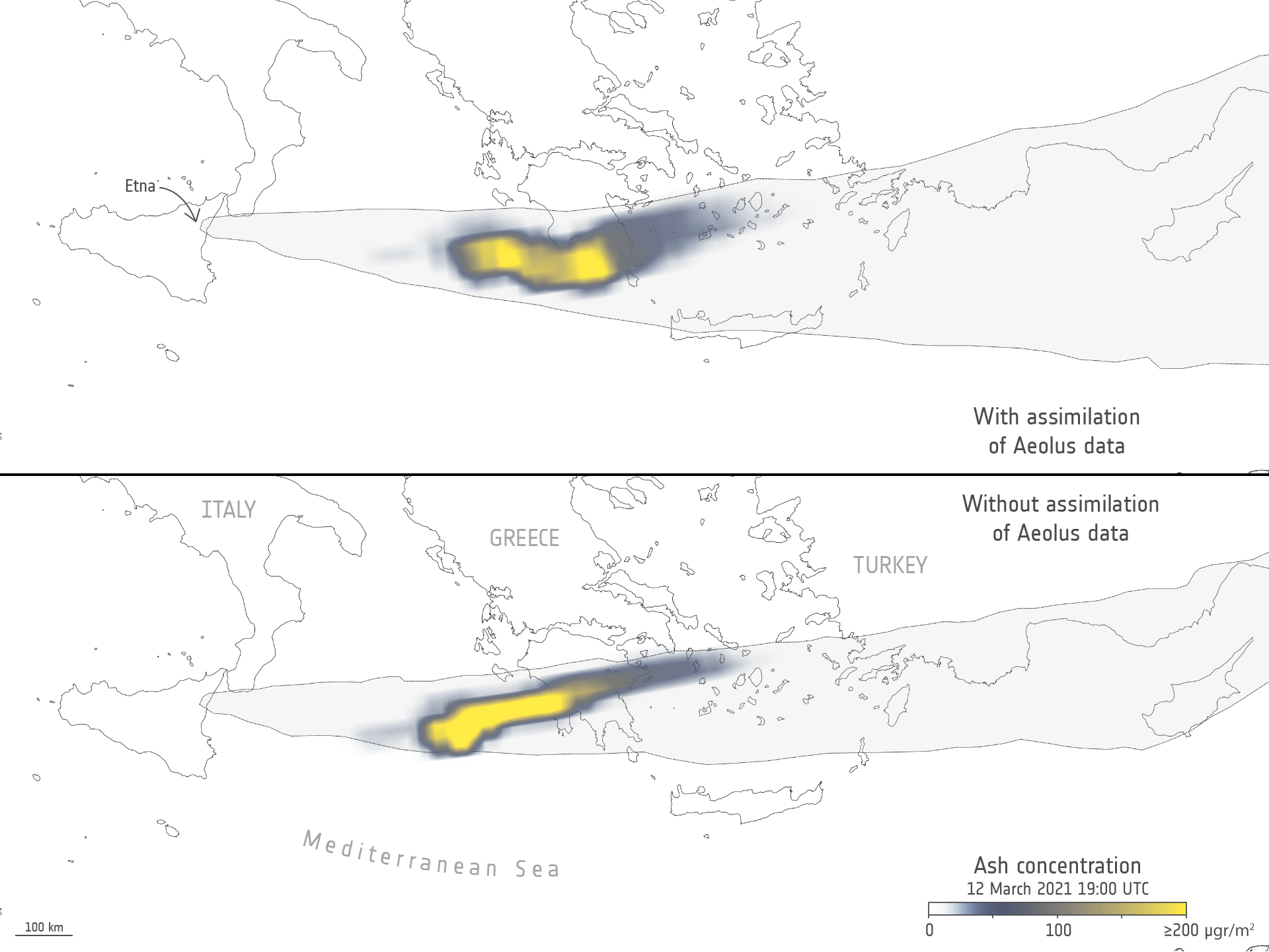
Aeolus enhances volcanic ash forecasts for aviation safety
rada / odborný rada v oddělení právních vztahů k nemovitostem na Katastrálním pracovišti Jablonec na
30.5.2023 7:21 ČÚZK - předpisy a opatření Katastrální úřad pro Liberecký kraj Katastrální pracoviště Jablonec nad Nisouvypisuje výběrové řízení na místo
rada / odborný rada v oddělení právních vztahů k nemovitostem na Katastrálním pracovišti Jablonec nad Nisou Katastrálního úřadu pro Liberecký kraj
rada / odborný rada v oddělení právních vztahů k nemovitostem na Katastrálním pracovišti Jablonec na
30.5.2023 7:21 ČÚZK - volná místa Katastrální úřad pro Liberecký kraj Katastrální pracoviště Jablonec nad Nisou vypisuje výběrové řízení na místo rada / odborný rada v oddělení právních vztahů k nemovitostem na Katastrálním pracovišti Jablonec narada / odborný rada v oddělení právních vztahů k nemovitostem na Katastrálním pracovišti Jablonec na
30.5.2023 7:21 ČÚZK - volná místa Katastrální úřad pro Liberecký kraj - Katastrální pracoviště Jablonec nad Nisou vypisuje výběrové řízení na místo rada / odborný rada v oddělení právních vztahů k nemovitostem na Katastrálním pracovišti Jablonec narada / odborný rada v oddělení právních vztahů k nemovitostem na Katastrálním pracovišti Jablonec na
30.5.2023 7:21 ČÚZK /Urady/Katastralni-urady/Katastralni-urady/Katastralni-urad-pro-Liberecky-kraj/Uredni-deska/Oznameni-a-jina-uredni-sdeleni/Volna-mista/DMS/rada-odborny-rada-v-oddeleni-pravnich-vztahu-k-nemrada / odborný rada v oddělení právních vztahů k nemovitostem na Katastrálním pracovišti Jablonec na
30.5.2023 7:21 ČÚZK - předpisy a opatření Katastrální úřad pro Liberecký kraj - Katastrální pracoviště Jablonec nad Nisouvypisuje výběrové řízení na místo
rada / odborný rada v oddělení právních vztahů k nemovitostem na Katastrálním pracovišti Jablonec nad Nisou Katastrálního úřadu pro Liberecký kraj
Výběrové řízení na pozici rada / odborný rada v oddělení aktualizace katastru nemovitostí Katastráln
30.5.2023 7:10 ČÚZK /Urady/Katastralni-urady/Katastralni-urady/Katastralni-urad-pro-Kralovehradecky-kraj/Uredni-deska/Oznameni-a-jina-uredni-sdeleni/Volna-mista/DMS/Vyberove-rizeni-na-pozici-rada-odborny-rada-v-oddeVýběrové řízení na pozici rada / odborný rada v oddělení aktualizace katastru nemovitostí Katastráln
30.5.2023 7:10 ČÚZK - předpisy a opatření Katastrální úřad pro Královéhradecký kraj Katastrální pracoviště Jičínvypisuje výběrové řízení na místo
Výběrové řízení na pozici rada / odborný rada v oddělení aktualizace katastru nemovitostí Katastrálního pracoviště Jičín
Výběrové řízení na pozici rada / odborný rada v oddělení aktualizace katastru nemovitostí Katastráln
30.5.2023 7:10 ČÚZK - volná místa Katastrální úřad pro Královéhradecký kraj Katastrální pracoviště Jičín vypisuje výběrové řízení na místo Výběrové řízení na pozici rada / odborný rada v oddělení aktualizace katastru nemovitostí KatastrálnRada/odborný rada – inspektor Zeměměřického a katastrálního inspektorátu v Brně
30.5.2023 7:03 ČÚZK /Urady/Zememericke-a-katastralni-inspektoraty/Zememericke-a-katastralni-inspektoraty/Zememericky-a-katastralni-inspektorat-v-Brne/Uredni-deska/Oznameni-a-jina-uredni-sdeleni/Volna-mista/DMS/Rada-odborny-rada-–-inspektor-Zememerickeho-a-kataRada/odborný rada – inspektor Zeměměřického a katastrálního inspektorátu v Brně
30.5.2023 7:03 ČÚZK - předpisy a opatření Zeměměřický a katastrální inspektorát v Brněvypisuje výběrové řízení na místo
Rada/odborný rada – inspektor Zeměměřického a katastrálního inspektorátu v Brně
Rada/odborný rada – inspektor Zeměměřického a katastrálního inspektorátu v Brně
30.5.2023 7:03 ČÚZK - volná místa Zeměměřický a katastrální inspektorát v Brně vypisuje výběrové řízení na místo Rada/odborný rada – inspektor Zeměměřického a katastrálního inspektorátu v BrněOdstávka el. energie
29.5.2023 12:42 ČÚZK - předpisy a opatření Katastrální úřad pro Jihomoravský kraj - Katastrální pracoviště Znojmo zveřejnil novou aktualitu: V důsledku přerušení dodávky elektrické energie bude provoz Katastrálního pracoviště Znojmo dne 15.6.2023 od 11:30 do 14:00 hod. omezen.Děkujeme za pochopení.
Odstávka el. energie
29.5.2023 12:42 ČÚZK /Urady/Katastralni-urady/Katastralni-urady/Katastralni-urad-pro-Jihomoravsky-kraj/Katastralni-pracoviste/KP-Znojmo/O-uradu/Aktuality/Odstavka-el-energieDesáté setkání geodetů Jihočeského kraje
29.5.2023 11:51 ZeměměřičIng. Robert Šinkner (TKP geo) bude další týden ve čtvrtek 8. června v Českých Budějovicích moderovat desáté setkání geodetů Jihočeského kraje. Akce se koná v prostorách Vysoké školy technické a ekonomické v Českých Budějovicích. Prezence: od 8:30 Předpokládané ukončení: 14:40 Program setkání geodetů Jihočeského kraje 9:00 – 9:15 Zahájení 9:15 – 11:00 Blok I: Novela zeměměřického zákona Činnost APG a historie pokusů […]
The post Desáté setkání geodetů Jihočeského kraje appeared first on Zeměměřič.
Odevzdávání PDF souborů na KP ve formátu PDF/A
29.5.2023 11:39 GEUSware V rámci novelizace Katastrální vyhlášky k 1.1.2023 vzniká geodetům povinnost od 1.7.2023 odevzdávat na KP dokumenty ve formátu PDF/A. Program GEUS pro tisk do PDF využívá virtuální tiskárny. V článku naleznete postup, jak získat PDF/A verze PDF 1.7 pomocí různých programů.Odevzdávání PDF souborů na KP ve formátu PDF/A
29.5.2023 11:39 GEUSware V rámci novelizace Katastrální vyhlášky k 1.1.2023 vzniká geodetům povinnost od 1.7.2023 odevzdávat na KP dokumenty ve formátu PDF/A. Některá KP vyžadují formát PDF/A již nyní. Program GEUS pro tisk do PDF využívá virtuální tiskárny. V článku naleznete postup, jak získat PDF/A verze PDF 1.7 pomocí různých programů.Program semináře Unicorn GIS Day 2023. Energetika, umělá inteligence, contracting, BIM, CDE, monitoring rizik
29.5.2023 11:23 GeoBusinessFirma Unicorn pořádá seminář (fyzicky i streamovaný) se vstupem zdarma. Akce se koná ve středu 7. června 2023 v Praze (a na streamu, ke kterému se dostanete, když se zaregistrujete). Program letošního setkání je věnován energetice, umělé inteligenci, contractingu, BIM, CDE a monitoringu rizik. Program Unicorn GIS Day 2023 09:00 – 09:10 Zahájení 09:10 – […]
The post Program semináře Unicorn GIS Day 2023. Energetika, umělá inteligence, contracting, BIM, CDE, monitoring rizik appeared first on GeoBusiness.
Změny ve verzi JVF DTM 1.4.2.2: zapracovány požadavky související s DTM krajů
29.5.2023 10:39 ZeměměřičČeský úřad zeměměřický a katastrální představil chystané vývojové změny a úpravy ve jednotném výměnném formátu Digitální technické mapy ČR. Do verze JVF DTM 1.4.2.2 byly zapracovány požadavky, které vyvstaly především v souvislosti s aktualizací základní prostorové situace (ZPS) DTM krajů. 1. Vymezení oblasti aktualizace ZPS Součástí XML dokumentu s geodetickou aktualizační dokumentací (GAD) DTM je nově také zadání oblasti, ve […]
The post Změny ve verzi JVF DTM 1.4.2.2: zapracovány požadavky související s DTM krajů appeared first on Zeměměřič.
Pozvánka na virtuální setkání ÚOZI
29.5.2023 10:24 ZeměměřičOd 1. července 2023 vzniká zeměměřická komora ze zákona. Zákonná ustanovení jsou již známá a vyplývá z nich mnoho zajímavých informací, o kterých bychom jako zeměměřiči měli vědět. Asociace podnikatelů v geomatice (APG) dokázala svou heroickou snahou a úsilím zeměměřickou komoru vybudovat, tedy zajistit potřebnou shodu napříč politickými stranami, u ministerstev, jiných profesních komor a předložit – po spolupráci řady stran – odpovídající změnu […]
The post Pozvánka na virtuální setkání ÚOZI appeared first on Zeměměřič.
DAEX DESIGN Start pro truhláře a nábytkáře v akci do 31. 5. 2023
29.5.2023 9:09 ŠPINAR - software Vážení zákazníci, připravili jsme pro Vás DAEX DESIGN Start pro výrobce a návrháře nábytku a interiérů s rozšiřujícími bonusy do 31. 5. 2023DAEX DESIGN Start pro truhláře a nábytkáře v akci do 31. 5. 2023
29.5.2023 9:09 ŠPINAR - softwareVážení zákazníci, připravili jsme pro Vás DAEX DESIGN Start pro výrobce a návrháře nábytku a interiérů s rozšiřujícími bonusy do 31. 5. 2023
The post DAEX DESIGN Start pro truhláře a nábytkáře v akci do 31. 5. 2023 appeared first on ŠPINAR – software.
DAEX DESIGN Start pro truhláře a nábytkáře prodloužení akce s bonusy
29.5.2023 9:09 ŠPINAR - softwareVážení zákazníci, připravili jsme pro Vás DAEX DESIGN Start pro výrobce a návrháře nábytku a interiérů s rozšiřujícími bonusy do 28. 5. 2023
The post DAEX DESIGN Start pro truhláře a nábytkáře prodloužení akce s bonusy appeared first on ŠPINAR – software.
Změna poskytování map II. vojenského mapování a Speciálních map III. vojenského mapování
26.5.2023 21:55 CENIA - národní geoportál INSPIRE U mapových vrstev II. vojenské mapování a Speciální mapy III. vojenského mapování došlo ke změně odkazů, ze kterých jsou prohlížecí služby poskytovány. Pro vrstvu II. vojenského mapování je dlaždicová prohlížecí služba WMTS nově poskytována na adrese: https://gis.cenia.cz/mapcache/II_vojenske_mapovani/wmts?SERVICE=WMTS&REQUEST=GetCapabilities. Prohlížecí služba II. vojenského mapování je...odborný referent – zápisy v řízení V a Z, řízení o SP
26.5.2023 13:16 ČÚZK - volná místa Katastrální úřad pro Olomoucký kraj Katastrální pracoviště Hranice vypisuje výběrové řízení na místo odborný referent – zápisy v řízení V a Z, řízení o SPodborný referent – zápisy v řízení V a Z, řízení o SP
26.5.2023 13:16 ČÚZK /Urady/Katastralni-urady/Katastralni-urady/Katastralni-urad-pro-Olomoucky-kraj/Uredni-deska/Oznameni-a-jina-uredni-sdeleni/Volna-mista/DMS/odborny-referent-–-zapisy-v-rizeni-V-a-Z,-rizeni-oodborný referent – zápisy v řízení V a Z, řízení o SP
26.5.2023 13:16 ČÚZK - předpisy a opatření Katastrální úřad pro Olomoucký kraj Katastrální pracoviště Hranicevypisuje výběrové řízení na místo
odborný referent – zápisy v řízení V a Z, řízení o SP
odborný referent/vrchní referent – návrh zápisu v katastru
26.5.2023 13:06 ČÚZK - předpisy a opatření Katastrální úřad pro Olomoucký kraj Katastrální pracoviště Olomoucvypisuje výběrové řízení na místo
odborný referent/vrchní referent – návrh zápisu v katastru