


![]()

zprávy
zdroje zpráv:Návrh nového openBIM® standardu IDS předložen ke schválení buildingSMART
22.3.2023 11:33 czBIMbuildingSMART dokončuje přípravu nového openBIM® standardu pro „Information Delivery Specification“ (IDS) neboli pro specifikaci předávání informací. IDS je standardem pro definování požadavků na informace způsobem,...
Článek Návrh nového openBIM® standardu IDS předložen ke schválení buildingSMART se nejdříve objevil na czBIM.
Návrh nového openBIM® standardu IDS předložen ke schválení buildingSMART
22.3.2023 11:33 czBIMbuildingSMART dokončuje přípravu nového openBIM® standardu pro „Information Delivery Specification“ (IDS) neboli pro specifikaci předávání informací. IDS je standardem pro definování požadavků na informace způsobem,...
Článek Návrh nového openBIM® standardu IDS předložen ke schválení buildingSMART se nejdříve objevil na czBIM.
AUTO Škoda Fabia TDI 1,9 Combi
22.3.2023 9:30 ČÚZK /Urady/Zememericky-urad/Nabidka-majetku/AUTO-Skoda-Fabia-TDI-1,9-CombiAUTO Škoda Fabia TDI 1,9 Combi
22.3.2023 9:30 ČÚZK - předpisy a opatřeníZeměměřický úřad nabízí nepotřebný majetek k odkupu. Jedná se o
AUTO Škoda Fabia TDI 1,9 Combi
AUTO Škoda Fabia TDI 1,9 Combi
22.3.2023 9:30 Zeměměřický úřadZeměměřický úřad nabízí nepotřebný majetek k odkupu. Jedná se o
AUTO Škoda Fabia TDI 1,9 Combi
Odstávka mapových aplikací Geoportálu a výdeje dat
22.3.2023 9:09 Jihočeský krajV sobotu 25.3.2023 od 18:00 budou z technických důvodů nedostupné mapové aplikace Geoportálu a nebude možné žádat o výdej dat. Obnovení plného provozu předpokládáme v sobotu 25.3.2023 po 23:00.
rnrnOmlouváme se za komplikace
Přerušení dodávky elektřiny
22.3.2023 8:48 ČÚZK /Urady/Katastralni-urady/Katastralni-urady/Katastralni-urad-pro-Pardubicky-kraj/Katastralni-pracoviste/KP-Svitavy/O-uradu/Aktuality/Preruseni-dodavky-elektrinyPřerušení dodávky elektřiny
22.3.2023 8:48 ČÚZK - předpisy a opatření Katastrální úřad pro Pardubický kraj - Katastrální pracoviště Svitavy zveřejnil novou aktualitu:Aretinova mapa Čech v bojích třicetileté války [Knihovna geografie, byTopic]
22.3.2023 0:00 Katedra aplikované geoinformatiky a kartografie Přf UK O třetí nejstarší tištěné mapě Čech z 1. poloviny 17. století a jejím autorovi, kartografu Pavlu Aretinovi z Ehrenfeldu hovořila dr. Eva Novotná v pořadu Planetárium regionální stanice Českého rozhlasu - Sever.Z knižních novinek (II) - Světový den vody [Knihovna geografie, byTopic]
22.3.2023 0:00 Katedra aplikované geoinformatiky a kartografie Přf UK 22. března se slaví Světový den vody. V knihovně geografie si jej můžeme připomenout několika zajímavými novinkami ve fondu. Přijďte nás navštívit a začíst se do zajímavých publikací!Z knižních novinek (I) [Knihovna geografie, byTopic]
21.3.2023 16:35 Katedra aplikované geoinformatiky a kartografie Přf UK Letošní zima byla u nás podle meteorologických měření jednou z nejteplejších. Pojďte se tedy vypravit za chladem, sněhem a ledem alespoň symbolicky prostřednictvím nových přírůstků ve fondu Knihovny geografie!Výběrové řízení na pozici Vrchní ministerský rada v oddělení koncepčním a metodickém, v odboru územního plánování
21.3.2023 15:05 Blogující geomatici - FAV ZČUVYHLÁŠENÍ VÝBĚROVÉHO ŘÍZENÍ na služební místo vrchního ministerského rady v oddělení koncepčním a metodickém, v odboru územního plánování Co nabízíme: Možnost podílet se na tvorbě koncepce územního plánování v ČR. Rozmanitou činnost v oblasti digitalizace územního plánování. Možnost podílet se na zavádění inovativních řešení v územních plánování. Možnost profesního růstu zejména v oblasti digitalizace veřejné správy. Odměňování ve 14. platové třídě (tarifní plat od 34.840 Kč do 51.530 Kč podle délky Vaší započitatelné praxe) a osobní příplatek na základě Vašeho individuálního výkonu. Benefity naleznete na: https://www.mmr.cz/cs/kariera/benefity. Co očekáváme: Dosažené vzdělání v magisterském studijním programu. Na služebním místě budete vykonávat službu v oboru 41. Bydlení, územní plánování a stavební řád. Bližší informace jsou uvedeny v oznámení o vyhlášení výběrového řízení. Předpokládaný nástup v květnu 2023 nebo dle dohody.
| Datum vystavení | 21. 03. 2023 |
| Datum platnosti | 10. 04. 2023 |
| Doba trvání | Na dobu neurčitou |
| Smluvní vztah | Služební poměr |
OZNÁMENÍ O VYHLÁŠENÍ VÝBĚROVÉHO ŘÍZENÍ
na služební místo vrchního ministerského rady v oddělení koncepčním a metodickém, v odboru územního plánování
Č. j.: MMR-21210/2023-94
Datum: 21. března 2023
1. Údaje o služebním místě
Státní tajemnice Ministerstva pro místní rozvoj jako služební orgán příslušný podle § 10 odst. 1 písm. f) zákona č. 234/2014 Sb., o státní službě, ve znění pozdějších předpisů (dále jen „zákon“), vyhlašuje výběrové řízení na služební místo č. MMR_1241 vrchního ministerského rady v oddělení koncepčním a metodickém, v odboru územního plánování, v Ministerstvu pro místní rozvoj, se služebním působištěm v Praze.
Na služebním místě je státní služba (dále jen „služba“) vykonávána v oboru služby
41 – Bydlení, územní plánování a stavební řád.
Na služebním místě jsou vykonávány zejména následující činnosti:
- tvoří koncepci územního plánování ČR;
- tvoří koncepci digitalizace územně plánovacích dokumentací a podkladů, včetně standardizace těchto dokumentů;
- vypracovává metodické materiály související s digitalizací územně plánovacích dokumentací a podkladů, včetně tvorby vzorových dat a výstupů, spolupracuje na pořízení územně plánovacích podkladů (územní studie a územně analytické podklady) nezbytné k výkonu činnosti odboru;
- spolupracuje při pořizování dokumentů územního rozvoje řešících vzájemné vazby v území;
- spolupracuje v rámci metodické činnosti na úseku územně analytických podkladů, usměrňuje a sjednocuje výkon státní správy a praxi orgánů územního plánování;
- podílí se na vedení informačního systému územního plánování;
- podílí se na výkonu nadřízeného orgánu územního plánování, plní další úkoly dle pokynu příslušného představeného, které vyplývají z činnosti odboru územního plánování.
2. Údaje o složkách platu
Zveřejnění uvedených údajů o složkách platu nepředstavuje veřejný příslib.
Služební místo je zařazeno podle přílohy č. 1 k zákonu o státní službě do 14. platové třídy.
2.1 Platový tarif
Státnímu zaměstnanci přísluší platový tarif od 34.840 Kč do 51.530 Kč.
Státní zaměstnanec se zařadí do platového stupně podle započitatelné praxe a míry jejího zápočtu podle § 3 nařízení vlády č. 304/2014 Sb., o platových poměrech státních zaměstnanců, ve znění pozdějších předpisů.
2.2 Osobní příplatek
Rozpětí od 2.577 Kč do 7.730 Kč odpovídá průměrné výši osobního příplatku při dosahování dobrých výsledků ve služebním hodnocení ve služebních úřadech v České republice.
Osobní příplatek je nenároková složka platu, kterou lze ocenit státního zaměstnance za jeho znalosti, dovednosti, a především za jeho výkonnost. V závislosti na výsledku jeho služebního hodnocení tedy státnímu zaměstnanci přísluší osobní příplatek v rozmezí od 0 Kč do částky odpovídající 50 % platového tarifu nejvyššího platového stupně v platové třídě, do které je zařazeno služební místo, na kterém státní zaměstnanec vykonává službu, a u tzv. vynikajících, všeobecně uznávaných odborníků do částky odpovídající 100 %.
2.3 Odměny
Státnímu zaměstnanci, který splnil mimořádné nebo zvlášť významné služební úkoly nebo který dobrovolně převzal splnění naléhavých služebních úkolů za nepřítomného státního zaměstnance, lze poskytnout odměnu a státnímu zaměstnanci, který se bezprostředně nebo významně podílel na splnění předem stanoveného mimořádně náročného služebního úkolu, jež je z hlediska působnosti služebního úřadu zvlášť významné, lze poskytnout cílovou odměnu. Odměny jsou nenárokové, zpravidla se vyplácejí 2x ročně dle objemu disponibilních finančních prostředků.
3. Údaje o podmínkách výkonu služby
Služba na služebním místě bude vykonávána ve služebním poměru na dobu neurčitou.
Předpokládaným dnem nástupu do služby na služebním místě je 1. květen 2023 nebo dle dohody.
Délka stanovené týdenní služební doby je 40 hodin.
Další údaje o podmínkách výkonu služby naleznete na internetové stránce Ministerstva vnitra https://www.mvcr.cz/sluzba/soubor/ssp-c-3-2022-priloha-c-3b-podminky-vykonu-sluzby-text.aspx
Služební úřad poskytuje následující benefity: https://www.mmr.cz/cs/kariera/benefity
4. Podání žádosti
Posuzovány budou žádosti[1] o přijetí do služebního poměru a zařazení na služební místo nebo žádosti o zařazení na služební místo (dále jen „žádost“) podané ve lhůtě do 10. dubna 2023 (žádosti doručené po uplynutí této lhůty budou vyřazeny), tj. v této lhůtě:
- podané v elektronické podobě prostřednictvím datové schránky služebního úřadu 26iaava;
- podané v elektronické podobě podepsané uznávaným elektronickým podpisem na adresu elektronické pošty služebního úřadu podatelna@mmr.cz;
- doručené služebnímu orgánu prostřednictvím provozovatele poštovních služeb na adresu služebního úřadu Ministerstvo pro místní rozvoj, Staroměstské náměstí 6, 110 15 Praha 1;
- podané osobně na podatelnu služebního úřadu na výše uvedené adrese.
Obálka, resp. datová zpráva, obsahující žádost včetně požadovaných listin (příloh) musí být označena slovy: „Neotvírat“ a slovy „Výběrové řízení na služební místo vrchního ministerského rady v oddělení koncepčním a metodickém, č.j.: 21210/2023-94 MG“.
V žádosti je žadatel povinen uvést ID datové schránky nebo elektronickou adresu, na kterou mu budou doručovány písemnosti ve výběrovém řízení.
5. Podmínky účasti ve výběrovém řízení
Výběrového řízení na výše uvedené služební místo, se v souladu se zákonem může zúčastnit žadatel, který:
1) Splňuje základní předpoklady stanovené zákonem tj.:
a) je státním občanem České republiky[2], občanem jiného členského státu Evropské unie nebo občanem státu, který je smluvním státem Dohody o Evropském hospodářském prostoru [§ 25 odst. 1 písm. a) zákona];
b) dosáhl věku 18 let [§ 25 odst. 1 písm. b) zákona];
c) je plně svéprávný [§ 25 odst. 1 písm. c) zákona][3];
d) je bezúhonný [§ 25 odst. 1 písm. d) zákona][4];
e) dosáhl vzdělání stanoveného zákonem pro toto služební místo [§ 25 odst. 1 písm. e) zákona], tj. vysokoškolského vzdělání v magisterském studijním programu[5];
f) má potřebnou zdravotní způsobilost [§ 25 odst. 1 písm. f) zákona][6];
6. Další povinné přílohy
K žádosti dále žadatel přiloží:
a) strukturovaný profesní životopis[7]
b) motivační dopis
c) doklad o dosaženém vzdělání
7. Údaje o pohovoru
Se žadateli, jejichž žádost nebyla vyřazena, provede výběrová komise pohovor.
V případě dotazů k tomuto výběrovému řízení se můžete obrátit na Mgr. Magdalénu Dejmkovou na e-mailu Magdalena.Dejmkova@mmr.cz.
Ing. Zdeňka Pikešová, MPA
státní tajemnice Ministerstva pro místní rozvoj
Krátka správa č. 16/2023
21.3.2023 13:55 Komora geodetů a kartografů SRThe post Krátka správa č. 16/2023 appeared first on Komora geodetov a kartografov.
Krátka správa č. 16/2023
21.3.2023 13:55 Komora geodetů a kartografů SRThe post Krátka správa č. 16/2023 appeared first on Komora geodetov a kartografov.
Dubnový den s CAD technikem – bezplatná online konzultace pro vaši firmu
21.3.2023 12:00 Arkance Systems21. dubna 2023 - přihlaste se na nový termín akce společnosti Arkance Systems. Těšíme se na vás.
Zpráva Dubnový den s CAD technikem – bezplatná online konzultace pro vaši firmu pochází z arkance-systems.cz.
Dubnový den s CAD/PDM expertem – bezplatná online konzultace pro vaši firmu
21.3.2023 12:00 Arkance Systems21. dubna 2023 - přihlaste se na nový termín akce společnosti Arkance Systems. Těšíme se na vás.
Zpráva Dubnový den s CAD/PDM expertem – bezplatná online konzultace pro vaši firmu pochází z arkance-systems.cz.
Odborný referent/vrchní referent – obnova katastrálního operátu
21.3.2023 10:53 ČÚZK - předpisy a opatření Katastrální úřad pro Moravskoslezský kraj Katastrální pracoviště Třinecvypisuje výběrové řízení na místo
Odborný referent/vrchní referent – obnova katastrálního operátu
Odborný referent/vrchní referent – obnova katastrálního operátu
21.3.2023 10:53 ČÚZK - volná místa Katastrální úřad pro Moravskoslezský kraj Katastrální pracoviště Třinec vypisuje výběrové řízení na místo Odborný referent/vrchní referent – obnova katastrálního operátuVrchní referent/rada – obnova katastrálního operátu
21.3.2023 10:51 ČÚZK - předpisy a opatření Katastrální úřad pro Moravskoslezský kraj Katastrální pracoviště Ostravavypisuje výběrové řízení na místo
Vrchní referent/rada – obnova katastrálního operátu
Vrchní referent/rada – obnova katastrálního operátu
21.3.2023 10:51 ČÚZK - volná místa Katastrální úřad pro Moravskoslezský kraj Katastrální pracoviště Ostrava vypisuje výběrové řízení na místo Vrchní referent/rada – obnova katastrálního operátuRada/odborný rada – kontrola listin určených k záznamu
21.3.2023 10:47 ČÚZK - předpisy a opatření Katastrální úřad pro Moravskoslezský kraj Katastrální pracoviště Ostravavypisuje výběrové řízení na místo
Rada/odborný rada – kontrola listin určených k záznamu
Rada/odborný rada – kontrola listin určených k záznamu
21.3.2023 10:47 ČÚZK - volná místa Katastrální úřad pro Moravskoslezský kraj Katastrální pracoviště Ostrava vypisuje výběrové řízení na místo Rada/odborný rada – kontrola listin určených k záznamuRada/odborný rada – kontrola listin určených k záznamu
21.3.2023 10:47 ČÚZK /Urady/Katastralni-urady/Katastralni-urady/Katastralni-urad-pro-Moravskoslezsky-kraj/Uredni-deska/Oznameni-a-jina-uredni-sdeleni/Volna-mista/DMS/Rada-odborny-rada-–-kontrola-listin-urcenych-k-zazVrchní referent/rada – obnova katastrálního operátu
21.3.2023 10:41 ČÚZK - předpisy a opatření Katastrální úřad pro Moravskoslezský kraj Katastrální pracoviště Karvinávypisuje výběrové řízení na místo
Vrchní referent/rada – obnova katastrálního operátu
Vrchní referent/rada – obnova katastrálního operátu
21.3.2023 10:41 ČÚZK - volná místa Katastrální úřad pro Moravskoslezský kraj Katastrální pracoviště Karviná vypisuje výběrové řízení na místo Vrchní referent/rada – obnova katastrálního operátuVrchní referent/rada – obnova katastrálního operátu na
21.3.2023 10:38 ČÚZK - předpisy a opatření Katastrální úřad pro Moravskoslezský kraj Katastrální pracoviště Frýdek-Místekvypisuje výběrové řízení na místo
Vrchní referent/rada – obnova katastrálního operátu na
Vrchní referent/rada – obnova katastrálního operátu na
21.3.2023 10:38 ČÚZK - volná místa Katastrální úřad pro Moravskoslezský kraj Katastrální pracoviště Frýdek-Místek vypisuje výběrové řízení na místo Vrchní referent/rada – obnova katastrálního operátu naVrchní referent/rada – obnova katastrálního operátu na
21.3.2023 10:38 ČÚZK /Urady/Katastralni-urady/Katastralni-urady/Katastralni-urad-pro-Moravskoslezsky-kraj/Uredni-deska/Oznameni-a-jina-uredni-sdeleni/Volna-mista/DMS/Vrchni-referent-rada-–-obnova-katastralniho-op-(3)Vrchní referent/rada – obnova katastrálního operátu
21.3.2023 10:35 ČÚZK - předpisy a opatření Katastrální úřad pro Moravskoslezský kraj Katastrální pracoviště Frýdek-Místekvypisuje výběrové řízení na místo
Vrchní referent/rada – obnova katastrálního operátu
Vrchní referent/rada – obnova katastrálního operátu
21.3.2023 10:35 ČÚZK - volná místa Katastrální úřad pro Moravskoslezský kraj Katastrální pracoviště Frýdek-Místek vypisuje výběrové řízení na místo Vrchní referent/rada – obnova katastrálního operátuHappy International Forests Day!
21.3.2023 10:10 European GNSS Agency
Forests offer countless benefits – from purifying water to cleaning the air and capturing carbon to fight climate change. They also provide food, life-saving medicines and raw materials for building homes. And who hasn’t enjoyed going for a hike in the woods?
To celebrate the many benefits of healthy forests, the United Nations has designated today, 21 March, as the International Day of Forests. But more than celebrating, today is also a chance to raise awareness about the importance of protecting our forests.
“Conserving and sustainably using forests is one of the best ways of protecting our planet and our own well-being,” says EUSPA Executive Director Rodrigo da Costa. “It’s up to us to safeguard these precious natural resources – and EU Space and our Agency can help.”
From promoting reforestation to preventing deforestation, degradation and fires, the EU Space Programme is an essential tool for sustainable forest management. Here’s six ways that Copernicus, EGNOS and Galileo are all working to ensure that everyone can benefit from healthy forests.
1. Keeping an eye on carbon sinks
Trees are important carbon sinks, meaning they absorb more carbon from the atmosphere than they release. According to the Forest Information System for Europe (FISE), as of 2020, Europe’s forests were storing 92.1 gigatonnes of carbon. Unfortunately, when forests disappear or become degraded, all this stored carbon gets emitted back into the atmosphere.
This highlights the critical need to monitor the carbon stocks of forested regions – monitoring that can be done via Earth Observation. For example, using the Copernicus Land Monitoring Service, climate scientists can map and monitor forest biomass and estimate its potential to serve as a carbon sink.
2. Planting 3 billion trees
A key component of the EU Forest Strategy, which aims to improve the quantity and quality of Europe’s forests while also strengthening their protection, restoration and resilience, is to plant 3 billion new trees by 2030. According to the 2022 EUSPA EO and GNSS Market Report, Earth Observation will play a big part in achieving this goal.
With the climate and weather data provided by Copernicus, authorities can better understand how different tree species will adapt to droughts, heatwaves and other climate-induced extreme weather events. EO can also provide decision makers with the data on soil composition they need to ensure these new trees are planted in the right conditions.
3. Stopping deforestation
The UN estimates that every year the world loses nearly 4.7 million hectares of forested area. Much of this loss is due to deforestation, the process of converting forested land into other uses.
When it comes to detecting, mapping and monitoring this deforestation, nothing beats Earth Observation. For example, EO-based tools for forest monitoring are using Copernicus data, along with the optical and radar instruments onboard Sentinel satellites, to provide global information with a high acquisition frequency to forestry stakeholders completely free of charge.
4. Preventing illegal logging
Copernicus can even help prevent illegal logging – a major cause of deforestation. By flagging potential development and road construction happening within forests, EO data helps authorities look for illegal activity and predict where such activity is most likely to occur.
Authorities also use GNSS to track timbre movements, which can help increase the transparency and traceability of the timber supply chain, reducing the likelihood that illegal exportation goes unnoticed.
5. Sustainable forests management
Much of Europe’s forests are under the management of the forest industry and are used to source raw material to produce paper and wood products. If these forests aren’t sustainably managed, we could run out of raw material – which is why the forestry industry is keen on using EU Space.
Forest managers and owners use remote sensing technologies to gather data over the large, often remote swaths of land that managed forests cover. They then use this data to track relevant inventory and, based on this, optimise harvesting and planting plans.
The forestry industry also relies on GNSS for such precision operations as the guidance of machinery and the variable rate application of fertilisers and irrigation – all of which allow the timber industry to implement best practices in sustainable forest management.
Thanks to its more robust signals, Galileo performs better under dense tree canopies, enabling machine guidance in forest environments. Moreover, Galileo is used to guide drones, which are increasingly being utilised in forest management operations.
6. Fighting forests fires
With climate change causing extreme draughts, heatwaves and winds, forest fires are becoming an all-too frequent occurrence. Luckily, fire departments and decision makers can rely on Earth Observation to help mitigate the risk of fires before they happen and to battle them when they do. That’s because EO has the advantage of being able to provide wide geographic coverage and the ability to ‘see’ through clouds and smoke and rapidly capture images.
Firefighting teams are also replacing their ground-based systems and use of rotorcraft with drones equipped with a range of sensors for capturing data. Such systems are particularly beneficial in rural and remote areas, where EO-equipped drones guided by the precise positioning offered by GNSS can provide wildfire fighters with another layer of information – and protection.
7. Cassini Hackathon and EUSPA´s contribution
EUSPA is leading the Cassini hackathons and also there, forestry is a big topic! Earth observation to protect forests from bark beetle infestation was the idea of YOLANDA. Blaz & Matic were old friends, they met Primoz and Lucija at the Cassini Hackathon #4. They were all already familiar with the problem of bark beetle infestation, but only during the hackathon, they crafted a realistic plan for a software product that allows forest insurers/owners to have actionable insights from satellite imagery. The ultimate outcome is the preservation of our natural resources and an increase in CO2 sequestration.
Endless potential
As we celebrate International Forests Day, it’s important to remember that, while our forests are in trouble, there is still plenty we can do to help.
“From carbon monitoring to sustainable logging, Copernicus, Galileo and EGNOS are indispensable tools for protecting – even restoring – our forests,” concludes da Costa. “When these tools are paired with emerging technologies like drones, robots and artificial intelligence, the potential for preserving healthy forests for future generations is endless. The protection of our forests is critical not only for the environment but also for the success of the EU Green Deal and our collective efforts to combat climate change.”
To learn more about this potential, be sure to check out the dedicated chapter in the latest edition of our EO and GNSS Market Report and get in touch with EUSPA at market@euspa.europa.eu.
Media note: This feature can be republished without charge provided the European Union Agency for the Space Programme (EUSPA) is acknowledged as the source at the top or the bottom of the story. You must request permission before you use any of the photographs on the site. If you republish, we would be grateful if you could link back to the EUSPA website (http://www.euspa.europa.eu).
Happy International Forests Day!
21.3.2023 10:10 European GNSS AgencyForests offer countless benefits – from purifying water to cleaning the air and capturing carbon to fight climate change. They also provide food, life-saving medicines and raw materials for building homes. And who hasn’t enjoyed going for a hike in the woods?
To celebrate the many benefits of healthy forests, the United Nations has designated today, 21 March, as the International Day of Forests. But more than celebrating, today is also a chance to raise awareness about the importance of protecting our forests.
“Conserving and sustainably using forests is one of the best ways of protecting our planet and our own well-being,” says EUSPA Executive Director Rodrigo da Costa. “It’s up to us to safeguard these precious natural resources – and EU Space and our Agency can help.”
From promoting reforestation to preventing deforestation, degradation and fires, the EU Space Programme is an essential tool for sustainable forest management. Here’s six ways that Copernicus, EGNOS and Galileo are all working to ensure that everyone can benefit from healthy forests.
1. Keeping an eye on carbon sinks
Trees are important carbon sinks, meaning they absorb more carbon from the atmosphere than they release. According to the Forest Information System for Europe (FISE), as of 2020, Europe’s forests were storing 92.1 gigatonnes of carbon. Unfortunately, when forests disappear or become degraded, all this stored carbon gets emitted back into the atmosphere.
This highlights the critical need to monitor the carbon stocks of forested regions – monitoring that can be done via Earth Observation. For example, using the Copernicus Land Monitoring Service, climate scientists can map and monitor forest biomass and estimate its potential to serve as a carbon sink.
2. Planting 3 billion trees
A key component of the EU Forest Strategy, which aims to improve the quantity and quality of Europe’s forests while also strengthening their protection, restoration and resilience, is to plant 3 billion new trees by 2030. According to the 2022 EUSPA EO and GNSS Market Report, Earth Observation will play a big part in achieving this goal.
With the climate and weather data provided by Copernicus, authorities can better understand how different tree species will adapt to droughts, heatwaves and other climate-induced extreme weather events. EO can also provide decision makers with the data on soil composition they need to ensure these new trees are planted in the right conditions.
3. Stopping deforestation
The UN estimates that every year the world loses nearly 4.7 million hectares of forested area. Much of this loss is due to deforestation, the process of converting forested land into other uses.
When it comes to detecting, mapping and monitoring this deforestation, nothing beats Earth Observation. For example, EO-based tools for forest monitoring are using Copernicus data, along with the optical and radar instruments onboard Sentinel satellites, to provide global information with a high acquisition frequency to forestry stakeholders completely free of charge.
4. Preventing illegal logging
Copernicus can even help prevent illegal logging – a major cause of deforestation. By flagging potential development and road construction happening within forests, EO data helps authorities look for illegal activity and predict where such activity is most likely to occur.
Authorities also use GNSS to track timbre movements, which can help increase the transparency and traceability of the timber supply chain, reducing the likelihood that illegal exportation goes unnoticed.
5. Sustainable forests management
Much of Europe’s forests are under the management of the forest industry and are used to source raw material to produce paper and wood products. If these forests aren’t sustainably managed, we could run out of raw material – which is why the forestry industry is keen on using EU Space.
Forest managers and owners use remote sensing technologies to gather data over the large, often remote swaths of land that managed forests cover. They then use this data to track relevant inventory and, based on this, optimise harvesting and planting plans.
The forestry industry also relies on GNSS for such precision operations as the guidance of machinery and the variable rate application of fertilisers and irrigation – all of which allow the timber industry to implement best practices in sustainable forest management.
Thanks to its more robust signals, Galileo performs better under dense tree canopies, enabling machine guidance in forest environments. Moreover, Galileo is used to guide drones, which are increasingly being utilised in forest management operations.
6. Fighting forests fires
With climate change causing extreme draughts, heatwaves and winds, forest fires are becoming an all-too frequent occurrence. Luckily, fire departments and decision makers can rely on Earth Observation to help mitigate the risk of fires before they happen and to battle them when they do. That’s because EO has the advantage of being able to provide wide geographic coverage and the ability to ‘see’ through clouds and smoke and rapidly capture images.
Firefighting teams are also replacing their ground-based systems and use of rotorcraft with drones equipped with a range of sensors for capturing data. Such systems are particularly beneficial in rural and remote areas, where EO-equipped drones guided by the precise positioning offered by GNSS can provide wildfire fighters with another layer of information – and protection.
7. Cassini Hackathon and EUSPA´s contribution
EUSPA is leading the Cassini hackathons and also there, forestry is a big topic! Earth observation to protect forests from bark beetle infestation was the idea of YOLANDA. Blaz & Matic were old friends, they met Primoz and Lucija at the Cassini Hackathon #4. They were all already familiar with the problem of bark beetle infestation, but only during the hackathon, they crafted a realistic plan for a software product that allows forest insurers/owners to have actionable insights from satellite imagery. The ultimate outcome is the preservation of our natural resources and an increase in CO2 sequestration.

4th CASSINI Hackathon winners YOLANDA (Slovenia)
Endless potential
As we celebrate International Forests Day, it’s important to remember that, while our forests are in trouble, there is still plenty we can do to help.
“From carbon monitoring to sustainable logging, Copernicus, Galileo and EGNOS are indispensable tools for protecting – even restoring – our forests,” concludes da Costa. “When these tools are paired with emerging technologies like drones, robots and artificial intelligence, the potential for preserving healthy forests for future generations is endless. The protection of our forests is critical not only for the environment but also for the success of the EU Green Deal and our collective efforts to combat climate change.”
To learn more about this potential, be sure to check out the dedicated chapter in the latest edition of our EO and GNSS Market Report and get in touch with EUSPA at market@euspa.europa.eu.
Media note: This feature can be republished without charge provided the European Union Agency for the Space Programme (EUSPA) is acknowledged as the source at the top or the bottom of the story. You must request permission before you use any of the photographs on the site. If you republish, we would be grateful if you could link back to the EUSPA website (http://www.euspa.europa.eu).
Odborný/vrchní referent – obnova katastrálního operátu
21.3.2023 10:04 ČÚZK - volná místa Katastrální úřad pro Moravskoslezský kraj technický odbor vypisuje výběrové řízení na místo Odborný/vrchní referent – obnova katastrálního operátuOdborný/vrchní referent – obnova katastrálního operátu
21.3.2023 10:04 ČÚZK - předpisy a opatření Katastrální úřad pro Moravskoslezský kraj technický odborvypisuje výběrové řízení na místo
Odborný/vrchní referent – obnova katastrálního operátu
Odborný/vrchní referent – obnova katastrálního operátu
21.3.2023 10:04 ČÚZK /Urady/Katastralni-urady/Katastralni-urady/Katastralni-urad-pro-Moravskoslezsky-kraj/Uredni-deska/Oznameni-a-jina-uredni-sdeleni/Volna-mista/DMS/Odborny-vrchni-referent-–-obnova-katastralniho-opeVrchní referent/rada – kontrola aktualizace
21.3.2023 9:59 ČÚZK - předpisy a opatření Katastrální úřad pro Moravskoslezský kraj Katastrální pracoviště Opavavypisuje výběrové řízení na místo
Vrchní referent/rada – kontrola aktualizace
Vrchní referent/rada – kontrola aktualizace
21.3.2023 9:59 ČÚZK - volná místa Katastrální úřad pro Moravskoslezský kraj Katastrální pracoviště Opava vypisuje výběrové řízení na místo Vrchní referent/rada – kontrola aktualizaceEarth observation supports latest UN climate report
20.3.2023 16:30 ESA Observing the Earth
The final instalment of the sixth assessment report by the United Nations' Intergovernmental Panel on Climate Change (IPCC) has been released today. The report warns that the planet has already warmed 1.1°C above pre-industrial levels, resulting in more frequent and intense extreme weather events that are causing increasingly dangerous impacts on nature and people in every region of the world.
The report includes a greater contribution of Earth observation data than its previous iterations in providing the physical evidence of Earth’s changing climate system – from sea-level rise, growing greenhouse-gas emissions and melting sea ice.
referent/vrchní referent – informační a kontrolní pracovník
20.3.2023 15:52 ČÚZK /Urady/Katastralni-urady/Katastralni-urady/Katastralni-urad-pro-hlavni-mesto-Prahu/Uredni-deska/Oznameni-a-jina-uredni-sdeleni/Volna-mista/DMS/referent-vrchni-referent-–-informacni-a-kontrolni-referent/vrchní referent – informační a kontrolní pracovník
20.3.2023 15:52 ČÚZK /Urady/Katastralni-urady/Katastralni-urady/Katastralni-urad-pro-hlavni-mesto-Prahu/Uredni-deska/Oznameni-a-jina-uredni-sdeleni/Volna-mista/DMS/referent-vrchni-referent-–-informacni-a-kontrolnireferent/vrchní referent – informační a kontrolní pracovník
20.3.2023 15:52 ČÚZK - předpisy a opatření Katastrální úřad pro hlavní město Prahuvypisuje výběrové řízení na místo
referent/vrchní referent – informační a kontrolní pracovník
referent/vrchní referent – informační a kontrolní pracovník
20.3.2023 15:52 ČÚZK - volná místa Katastrální úřad pro hlavní město Prahu vypisuje výběrové řízení na místo referent/vrchní referent – informační a kontrolní pracovníkGIS Slovakia již od zítřka
20.3.2023 15:11 GISportal.cz
Online konference GIS Slovakia začíná již zítra (úterý 21.3.) a bude se konat do čtvrtka 23.3. Konference je přístupná všem zdarma skrze MS Teams. Více informací naleznete také jako event na Facebooku. Program konference je zaměřený především na praktické využití GIS nejen ve státní sféře na Slovensku, ale i v ČR. Utorok 21.3.2023 ********************************************************************************************* 09:09 […]
The post GIS Slovakia již od zítřka appeared first on GISportal.cz.
GIS Slovakia již od zítřka
20.3.2023 15:11 GISportal.czOnline konference GIS Slovakia začíná již zítra (úterý 21.3.) a bude se konat do čtvrtka 23.3. Konference je přístupná všem zdarma skrze MS Teams. Více informací naleznete také jako event na Facebooku. Program konference je zaměřený především na praktické využití GIS nejen ve státní sféře na Slovensku, ale i v ČR. Utorok 21.3.2023 ********************************************************************************************* 09:09 […]
The post GIS Slovakia již od zítřka appeared first on GISportal.cz.
Pozvánka na „Deň otvorených výkopov v Radetone“
20.3.2023 14:45 Geotronics.sk Srdečne Vás pozývame na DEŇ OTVORENÝCH VÝKOPOV V RADETONE V spolupráci s Radeton SK s.r.o. a so zástupcom Geotronics Slovakia, s.r.o. môžete stretnúť už tento týždeň 23. a 24. marca 2023 v českom sídle RADETON v Brne. Pozvánku na toto podujatie nájdete TU: Na tomto mieste je vybudovaný veľký polygón rôznych podzemných vedení, na ktorých si [...]Pozvánka na „Deň otvorených výkopov v Radetone“
20.3.2023 14:45 Geotronics.sk Srdečne Vás pozývame na DEŇ OTVORENÝCH VÝKOPOV V RADETONE V spolupráci s Radeton SK s.r.o. sa so zástupcom Geotronics Slovakia, s.r.o. môžete stretnúť už tento týždeň 23. a 24. marca 2023 v českom sídle RADETON v Brne. Pozvánku na toto podujatie nájdete TU: Na tomto mieste je vybudovaný veľký polygón rôznych podzemných vedení, na ktorých si môžete [...]Pozvánka na „Deň otvorených výkopov v Radetone“
20.3.2023 14:45 Geotronics.sk Srdečne Vás pozývame na DEŇ OTVORENÝCH VÝKOPOV V RADETONE V spolupráci s Radeton SK s.r.o. a so zástupcom Geotronics Slovakia, s.r.o. môžete stretnúť už tento týždeň 23. a 24. marca 2023 v českom sídle RADETON v Brne. Pozvánku na toto podujatie nájdete TU: Na tomto mieste je vybudovaný veľký polygón rôznych podzemných vedení, na ktorých si [...]Webinář - Efektivní využití produktu Autodesk Docs
20.3.2023 13:26 Adeon
Společnost Adeon CZ srdečně zve všechny zájemce na exkluzivní webinář, který se bude zaměřovat na produkt Autodesk DOCS z platformy […]
The post Webinář - Efektivní využití produktu Autodesk Docs appeared first on Adeon CZ.
Nedostupné telefonní linky na KP Klatovy
20.3.2023 13:24 ČÚZK /Urady/Katastralni-urady/Katastralni-urady/Katastralni-urad-pro-Plzensky-kraj/Katastralni-pracoviste/KP-Klatovy/O-uradu/Aktuality/Nedostupne-telefonni-linky-na-KP-KlatovyNedostupné telefonní linky na KP Klatovy
20.3.2023 13:24 ČÚZK - předpisy a opatření Katastrální úřad pro Plzeňský kraj - Katastrální pracoviště Klatovy zveřejnil novou aktualitu: V době od 23. 3. 2023 8:00 do 18:00 dojde na pracovišti Klatovy k plánované výluce služeb firmy Ha-vel z důvodu práce v síti operátora. Po tuto dobu nebudou dostupné telefonní linky na KP Klatovy.Nedostupné telefonní linky na KP Klatovy
20.3.2023 13:21 ČÚZK - předpisy a opatření Katastrální úřad pro Plzeňský kraj - Katastrální pracoviště Klatovy zveřejnil novou aktualitu: V době od 23. 3. 2023 8:00 do 18:00 dojde na pracovišti Klatovy k plánované výluce služeb firmy Ha-vel z důvodu práce v síti operátora. Po tuto dobu nebudou dostupné telefonní linky na KP Klatovy.Nedostupné telefonní linky na KP Klatovy
20.3.2023 13:21 ČÚZK /Urady/Katastralni-urady/Katastralni-urady/Katastralni-urad-pro-Plzensky-kraj/O-uradu/Aktuality/Nedostupne-telefonni-linky-na-KP-KlatovyVŘ správce IKT
20.3.2023 9:49 ČÚZK /Urady/Zememericky-urad/Uredni-deska/Oznameni-a-jina-uredni-sdeleni/Volna-mista/DMS/VR-spravce-IKTVŘ správce IKT
20.3.2023 9:49 ČÚZK - volná místa Zeměměřický úřad vypisuje výběrové řízení na místo VŘ správce IKTVŘ správce IKT
20.3.2023 9:49 ČÚZK - předpisy a opatření Zeměměřický úřadvypisuje výběrové řízení na místo
VŘ správce IKT
VŘ správce IKT
20.3.2023 9:49 Zeměměřický úřad Zeměměřický úřadvypisuje výběrové řízení na místo
VŘ správce IKT
Ceny rektorky pro studenty katedry [Katedra aplikované geoinformatiky a kartografie, byTopic]
20.3.2023 8:25 Katedra aplikované geoinformatiky a kartografie Přf UK Mezi laureáty letošních Cen rektorky Univerzity Karlovy jsou Petra Krsková a Mojmír Polák, kteří obhájili své práce na Katedře aplikované geoinformatiky a kartografie. Gratulujeme!Ceny rektorky pro studenty katedry [Katedra aplikované geoinformatiky a kartografie, byTopic]
20.3.2023 8:25 Katedra aplikované geoinformatiky a kartografie Přf UKAnalytik IKT / Analytička IKT
20.3.2023 8:03 ČÚZK /Urady/Zememericky-urad/Volna-mista/DMS/Analytik-IKT-Analyticka-IKTAnalytik IKT / Analytička IKT
20.3.2023 8:03 ČÚZK - předpisy a opatření Zeměměřický úřadvypisuje výběrové řízení na místo
Analytik IKT / Analytička IKT
Analytik IKT / Analytička IKT
20.3.2023 8:03 ČÚZK - volná místa Zeměměřický úřad vypisuje výběrové řízení na místo Analytik IKT / Analytička IKTAnalytik IKT / Analytička IKT
20.3.2023 8:03 Zeměměřický úřad Zeměměřický úřadvypisuje výběrové řízení na místo
Analytik IKT / Analytička IKT
ISPRS e-bulletin: 2023 – Issue No.1
19.3.2023 21:48 Společnost pro fotogrammetrii a dálkový průzkumISPRS e-bulletin: 2023 – Issue No.1
The post ISPRS e-bulletin: 2023 – Issue No.1 appeared first on SFDP.
ISPRS e-bulletin: 2023 – Issue No.1
19.3.2023 21:48 Společnost pro fotogrammetrii a dálkový průzkum ISPRS e-bulletin: 2023 – Issue No.1ISPRS e-bulletin: 2023 – Issue No.1
19.3.2023 21:48 Společnost pro fotogrammetrii a dálkový průzkum ISPRS e-bulletin: 2023 – Issue No.1TurboCAD Platinum 28 CZ + přes 30 miliónů CAD Symbolů
19.3.2023 16:52 ŠPINAR - softwarePřipravili jsme pro Vás skvělé spojení TurboCAD Platinum + CAD Symbols v akční ceně do 26 3. 2023,
The post TurboCAD Platinum 28 CZ + přes 30 miliónů CAD Symbolů appeared first on ŠPINAR – software.
TurboCAD Platinum a přes 30 miliónů CAS Symbolů
19.3.2023 16:52 ŠPINAR - softwareTurboCAD Designer 28 CZ v akční ceně do 19. 3. 2023,
The post TurboCAD Platinum a přes 30 miliónů CAS Symbolů appeared first on ŠPINAR – software.
TurboCAD Platinum + přes 30 miliónů CAD Symbolů
19.3.2023 16:52 ŠPINAR - softwarePřipravili jsme pro Vás skvělé spojení TurboCAD Platinum + CAD Symbols v akční ceně do 26 3. 2023,
The post TurboCAD Platinum + přes 30 miliónů CAD Symbolů appeared first on ŠPINAR – software.
Securing the EU Space Programme starts with EUSPA
17.3.2023 16:06 European GNSS Agency
From 6 to 10 March 2023, the EU conducted the Space Threat Response Architecture (STRA) 2023 exercise at the European External Action Service (EEAS) Headquarters in Brussels.
The STRA exercise is a yearly exercise to test and enhance the EU´s response to threats to the systems and services deployed under the various components of the EU Space Programme. It builds on a scenario, which reflects the complexity of the current geopolitical landscape and emerging hybrid threats, ranging from cyber-attacks on space and ground segments to spoofing or jamming satellite signals, as well as disinformation campaigns.
During the STRA 2023 exercise, the EU´s space threat response mechanism was triggered by a cyber-security incident affecting Galileo. The incident was activated in EEAS HQ and involved key political, diplomatic and operational actors including Member States, the EEAS, the EU Space Programme Agency (EUSPA /Galileo Security Monitoring Centre), the Commission and the Council of the European Union. Italy and Spain as Galileo host nations activated their chain of command, involving appropriate national capabilities to address the incident and providing support to digital forensics and critical infrastructure protection measures.
During this exercise, the Agency demonstrated that its mission in implementing the operational security of Galileo as a component of the European Union Space Programme is fulfilled.
“EUSPA continues to take steps to ensure the security of the EU Space Programme and the confidentiality, integrity and availability of the data and services it provides,” says EUSPA Executive Director Rodrigo da Costa.
Central to this role is the Galileo Security Monitoring Centre (GSMC).
Around-the-clock monitoring
The GSMC monitors and, when necessary, acts regarding security threats, security alerts and the operational status of Galileo’s various components. It operates its mission from the two facilities in Saint-Germain-en-Laye, France, and in San Martín de la Vega, Spain.
“We provide around-the-clock monitoring of the Galileo system’s security,” explains GSMC Head Philippe Rosius. “The purpose of this monitoring is to detect accidental or deliberate security events that could cause a disruption to the programme’s services.”
In the event of a threat to the security of the system and/or its services that could affect the security of the EU, the European Council will issue specific instructions to EUSPA, which the GSMC is responsible for implementing.
Beyond its monitoring duties, the GSMC is also responsible for managing access to the Public Regulated Service (PRS) and for ensuring that sensitive information relating to its use is properly managed and protected.
“While the GSMC is an integral part of the Galileo infrastructure, it has the competence to be extended to other components of the Union Space Programme,” adds Rosius.
Security expertise to support EU priorities
EUSPA’s security expertise also makes it well-positioned to support the objectives of the recently adopted European Union Space Strategy for Security and Defence.
Proposed by EU High Representative/Vice-President for Foreign Affairs and Security Policy Josep Borrell, Executive Vice-President for A Europe Fit for the Digital Age of the European Commission, Margrethe Vestager and European Commissioner for the Internal Market Thierry Breton, the Strategy proposes actions to strengthen the resilience and protection of space systems and services in the EU EUSPA will have a key role to play for the implementation of this strategy. Firstly, the strategy proposes the creation of a Sharing and Analysis Centre (EU Space ISAC) to raise awareness and facilitate the exchange of best practices among commercial and relevant public entities on resilience measures for space capabilities.
Building on its experience with Galileo, EUSPA can ensure consistent security monitoring of all EU space programmes. In close cooperation with the Commission, the Computer Security Incident Response Team of all the EU institutions (CERT-EU) and the European Union Agency for Cybersecurity (ENISA), EUSPA will play a key role as space security monitoring and operations centre in the EU. On request, we will be ready to also assist operators of essential space systems and services across the EU27.
With user needs being always the basis of the EU Space Programme, the Commission is seeking to embed military and security user requirements in the design of relevant new EU space systems and the upgrade of existing systems. Being a user-oriented agency, EUSPA will support the identification of security-related needs, and the accreditation and exploitation of dual-use systems and services.
“Thanks to its robust security apparatus, EUSPA is an essential partner in keeping all of Europe’s space assets and the important data and services they provide safe and secure,” concludes da Costa.
Media note: This feature can be republished without charge provided the European Union Agency for the Space Programme (EUSPA) is acknowledged as the source at the top or the bottom of the story. You must request permission before you use any of the photographs on the site. If you republish, we would be grateful if you could link back to the EUSPA website (http://www.euspa.europa.eu).
IFC 4.3 Progress Report and Next Steps
17.3.2023 16:05 buildingSMART.orgBy Clive Billiald IFC 4.3 formally entered the next stage of the ISO process – the DIS (Draft International Standard) voting phase – on 20th February 2023. This was…
The post IFC 4.3 Progress Report and Next Steps appeared first on buildingSMART International.
Earth from Space: Okavango Delta, Botswana
17.3.2023 10:00 ESA Observing the Earth Image:
Botswana’s Okavango Delta – the world’s largest inland delta – is featured in this multitemporal radar image, captured by the Copernicus Sentinel-1 mission.
Image:
Botswana’s Okavango Delta – the world’s largest inland delta – is featured in this multitemporal radar image, captured by the Copernicus Sentinel-1 mission.
Mapová aplikace ÚPD - nové dokumentace
17.3.2023 8:24 Jihočeský krajV mapové aplikaci Územně plánovací dokumentace obcí byla aktualizována ÚPD obcí ORP České Budějovice – Hůry, Hluboká nad Vltavou, Boršov nad Vltavou, Staré Hodějovice, Dynín, Záboří, Dasný, Dívčice, Ledenice, Lipí, Žabovřesky, Dobrá Voda, Ševětín, Planá, ORP Týn nad Vltavou – Bečice.
Guide to the Use of Industry Foundation Classes in Exchange of Reinforcement Models
16.3.2023 20:00 buildingSMART.orgThe American Concrete Institute have produced a user guide on how to use IFC in the exchange of reinforcement models. ACI have been working with the Building Room steering committee…
The post Guide to the Use of Industry Foundation Classes in Exchange of Reinforcement Models appeared first on buildingSMART International.
referent KN – zápis do protokolu řízení V a Z
16.3.2023 17:00 ČÚZK - předpisy a opatření Katastrální úřad pro hlavní město Prahuvypisuje výběrové řízení na místo
referent KN – zápis do protokolu řízení V a Z
referent KN – zápis do protokolu řízení V a Z
16.3.2023 17:00 ČÚZK - volná místa Katastrální úřad pro hlavní město Prahu vypisuje výběrové řízení na místo referent KN – zápis do protokolu řízení V a Zreferent KN – zápis do protokolu řízení V a Z
16.3.2023 17:00 ČÚZK /Urady/Katastralni-urady/Katastralni-urady/Katastralni-urad-pro-hlavni-mesto-Prahu/Uredni-deska/Oznameni-a-jina-uredni-sdeleni/Volna-mista/DMS/referent-KN-–-zapis-do-protokolu-rizeni-V-a-Z20230316_Odborný rada oddělení právních vztahů k nemovitostem
16.3.2023 13:58 ČÚZK - předpisy a opatření Katastrální úřad pro Středočeský kraj - Katastrální pracoviště Rakovník Vyhlášení výběrového řízení: odborný rada oddělení právních vztahů k nemovitostem V části "Úřední deska", v sekci "Oznámení a jiná úřední sdělení" bylo vystaveno "Oznámení o vyhlášení výběrového řízení na obsazení služebního místa odborný rada oddělení právních vztahů k nemovitostem"20230316_Odborný rada oddělení právních vztahů k nemovitostem
16.3.2023 13:58 ČÚZK /Urady/Katastralni-urady/Katastralni-urady/Katastralni-urad-pro-Stredocesky-kraj/Katastralni-pracoviste/KP-Rakovnik/O-uradu/Aktuality/20230111_Odborny-rada-oddeleni-pravnich-vztahu-(3)Odborný rada oddělení právních vztahů k nemovitostem
16.3.2023 13:57 ČÚZK - volná místa Katastrální úřad pro Středočeský kraj Katastrální pracoviště Rakovník vypisuje výběrové řízení na místo Odborný rada oddělení právních vztahů k nemovitostemOdborný rada oddělení právních vztahů k nemovitostem
16.3.2023 13:57 ČÚZK - předpisy a opatření Katastrální úřad pro Středočeský kraj Katastrální pracoviště Rakovníkvypisuje výběrové řízení na místo
Odborný rada oddělení právních vztahů k nemovitostem
odborný referent / vrchní referent v oddělení právních vztahů k nemovitostem na Katastrálním pracovi
16.3.2023 13:49 ČÚZK - volná místa Katastrální úřad pro Liberecký kraj Katastrální pracoviště Liberec vypisuje výběrové řízení na místo odborný referent / vrchní referent v oddělení právních vztahů k nemovitostem na Katastrálním pracoviodborný referent / vrchní referent v oddělení právních vztahů k nemovitostem na Katastrálním pracovi
16.3.2023 13:49 ČÚZK - předpisy a opatření Katastrální úřad pro Liberecký kraj - Katastrální pracoviště Liberecvypisuje výběrové řízení na místo
odborný referent / vrchní referent v oddělení právních vztahů k nemovitostem na Katastrálním pracovišti Liberec Katastrálního úřadu pro Liberecký kraj
Nové číslo GaKO
16.3.2023 10:43
ÚGKK SR
Nové číslo časopisu Geodetického a Kartografického Obzoru 03/2023
20230215_Rada / odborný rada oddělení aktualizace KN
16.3.2023 10:29 ČÚZK /Urady/Katastralni-urady/Katastralni-urady/Katastralni-urad-pro-Stredocesky-kraj/Katastralni-pracoviste/KP-Pribram/O-uradu/Aktuality/20210922_Odborny-referent-oddeleni-aktualizace-(4)20230215_Rada / odborný rada oddělení aktualizace KN
16.3.2023 10:29 ČÚZK - předpisy a opatření Katastrální úřad pro Středočeský kraj - Katastrální pracoviště Příbram Vyhlášení výběrového řízení: Rada / odborný rada oddělení aktualizace KN V části "Úřední deska", v sekci "Oznámení a jiná úřední sdělení" bylo vystaveno "Oznámení o vyhlášení výběrového řízení na obsazení služebního místa Rada / odborný rada oddělení aktualizace KN"Rada / odborný rada oddělení aktualizace KN
16.3.2023 10:26 ČÚZK - předpisy a opatření Katastrální úřad pro Středočeský kraj Katastrální pracoviště Příbramvypisuje výběrové řízení na místo
Rada / odborný rada oddělení aktualizace KN
Rada / odborný rada oddělení aktualizace KN
16.3.2023 10:26 ČÚZK /Urady/Katastralni-urady/Katastralni-urady/Katastralni-urad-pro-Stredocesky-kraj/Uredni-deska/Oznameni-a-jina-uredni-sdeleni/Volna-mista/DMS/Rada-odborny-rada-oddeleni-aktualizace-KNRada / odborný rada oddělení aktualizace KN
16.3.2023 10:26 ČÚZK - volná místa Katastrální úřad pro Středočeský kraj Katastrální pracoviště Příbram vypisuje výběrové řízení na místo Rada / odborný rada oddělení aktualizace KN20230316_Odborný / vrchní referent oddělení obnovy a revize KN
16.3.2023 10:09 ČÚZK - předpisy a opatření Katastrální úřad pro Středočeský kraj - Katastrální pracoviště Praha-západ Vyhlášení výběrového řízení: Odborný / vrchní referent oddělení obnovy a revize KN V části "Úřední deska", v sekci "Oznámení a jiná úřední sdělení" bylo vystaveno "Oznámení o vyhlášení výběrového řízení na obsazení služebního místa Odborný / vrchní referent oddělení obnovy a revize KN"20230316_Odborný / vrchní referent oddělení obnovy a revize KN
16.3.2023 10:09 ČÚZK /Urady/Katastralni-urady/Katastralni-urady/Katastralni-urad-pro-Stredocesky-kraj/Katastralni-pracoviste/KP-Praha-zapad/O-uradu/Aktuality/20210922_Odborny-referent-oddeleni-aktualizac-(8)20230316_Vrchní referent / rada oddělení obnovy a revize KN
16.3.2023 9:41 ČÚZK /Urady/Katastralni-urady/Katastralni-urady/Katastralni-urad-pro-Stredocesky-kraj/Katastralni-pracoviste/KP-Praha-zapad/O-uradu/Aktuality/20210922_Odborny-referent-oddeleni-aktualizac-(7)20230316_Vrchní referent / rada oddělení obnovy a revize KN
16.3.2023 9:41 ČÚZK - předpisy a opatření Katastrální úřad pro Středočeský kraj - Katastrální pracoviště Praha-západ Vyhlášení výběrového řízení: Vrchní referent / rada oddělení obnovy a revize KN V části "Úřední deska", v sekci "Oznámení a jiná úřední sdělení" bylo vystaveno "Oznámení o vyhlášení výběrového řízení na obsazení služebního místa Vrchní referent / rada oddělení obnovy a revize KN"20230316_Odborný / vrchní referent oddělení aktualizace GI KN
16.3.2023 9:01 ČÚZK - předpisy a opatření Katastrální úřad pro Středočeský kraj - Katastrální pracoviště Praha-západ Vyhlášení výběrového řízení: Odborný / vrchní referent oddělení aktualizace GI KN V části "Úřední deska", v sekci "Oznámení a jiná úřední sdělení" bylo vystaveno "Oznámení o vyhlášení výběrového řízení na obsazení služebního místa Odborný / vrchní referent oddělení aktualizace GI KN"20230316_Odborný / vrchní referent oddělení aktualizace GI KN
16.3.2023 9:01 ČÚZK /Urady/Katastralni-urady/Katastralni-urady/Katastralni-urad-pro-Stredocesky-kraj/Katastralni-pracoviste/KP-Praha-zapad/O-uradu/Aktuality/20210922_Odborny-referent-oddeleni-aktualizac-(6)Your Bathymetric Survey Partner SatLab HydroBoat 990 Is Here
16.3.2023 9:00 Satlab Geosolutions Date: 21 March 2023 What do you need to prepare for bathymetry and hydrography […]Odborný / vrchní referent oddělení aktualizace GI KN
16.3.2023 8:56 ČÚZK - volná místa Katastrální úřad pro Středočeský kraj vypisuje výběrové řízení na místo Odborný / vrchní referent oddělení aktualizace GI KNOdborný / vrchní referent oddělení aktualizace GI KN
16.3.2023 8:56 ČÚZK - předpisy a opatření Katastrální úřad pro Středočeský krajvypisuje výběrové řízení na místo
Odborný / vrchní referent oddělení aktualizace GI KN
Odborný / vrchní referent oddělení aktualizace GI KN
16.3.2023 8:56 ČÚZK - volná místa Katastrální úřad pro Středočeský kraj - Katastrální pracoviště Praha-západ vypisuje výběrové řízení na místo Odborný / vrchní referent oddělení aktualizace GI KNOdborný / vrchní referent oddělení aktualizace GI KN
16.3.2023 8:56 ČÚZK - předpisy a opatření Katastrální úřad pro Středočeský kraj - Katastrální pracoviště Praha-západvypisuje výběrové řízení na místo
Odborný / vrchní referent oddělení aktualizace GI KN
Porucha
16.3.2023 8:52 ČÚZK - předpisy a opatření Katastrální úřad pro Plzeňský krajzveřejnil novou aktualitu: Z důvodu poruchy ústředny jsou nefunkční telefonní linky KP Domažlice.
Porucha
16.3.2023 8:52 ČÚZK /Urady/Katastralni-urady/Katastralni-urady/Katastralni-urad-pro-Plzensky-kraj/O-uradu/Aktuality/PoruchaGaKO 3/2023
16.3.2023 8:39 GaKO GaKO 3/2023 ĎURAČIOVÁ, R.–JANÁK, J.–GERHÁTOVÁ, Ľ.–LIESKOVSKÝ, T.–PAPČO, J.: Od geodetických základov ku globálnej geodézii a geoinformatike – aktuálne otázky výskumu na katedreTalk with us on Ocean Business 2023 in Southampton, UK
16.3.2023 4:25 Satlab Geosolutions See you in the UK and discuss the possibility and opportunities in the ocean industrybuildingSMART International Awards 2023 is Now Open
15.3.2023 20:02 buildingSMART.orgLondon, U.K. - March 15, 2023 - London, - buildingSMART International (bSI) is delighted to announce that the annual openBIM® Awards Program is open. Registration opens on March 15, 2023. Since its launch,…
The post buildingSMART International Awards 2023 is Now Open appeared first on buildingSMART International.
Recovering forests regain a quarter of carbon lost from deforestation
15.3.2023 17:00 ESA Observing the Earth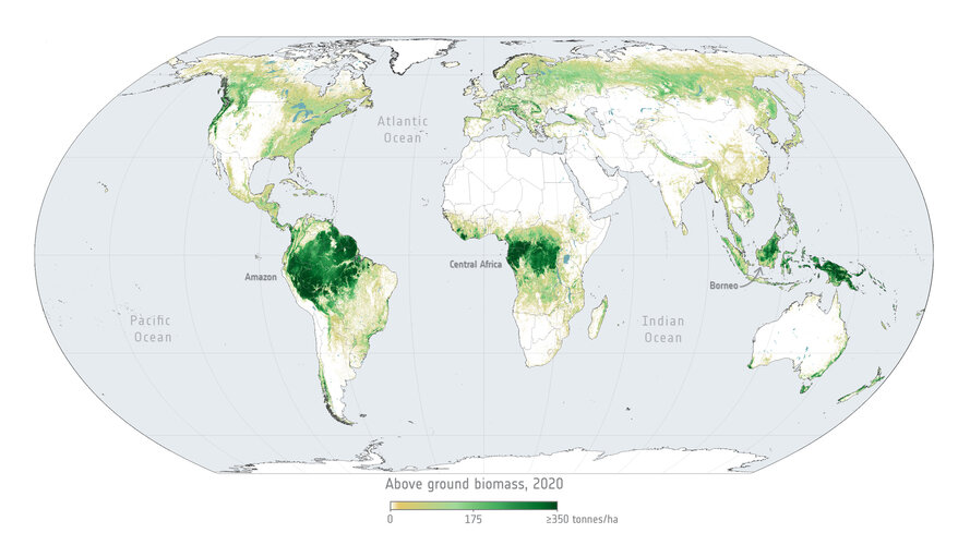
RSS kanál oživen
15.3.2023 16:59 GEPROOživením kanálu RSS vám chceme pomoci dosáhnout lepší informovanost a získat rychlejší přehled o novinkách publikovaných na našem webu www.gepro.cz. Jedná se především o informace typu: nové verze produků, aktualizace, opravy nebo úpravy softwaru, pořádání školení, setkání uživatelů apod.Pokud RSS čtečky používáte, můžete si si ke svým zdrojům informací přidat také naše stránky. Pokud s …
RSS kanál oživen Pokračovat ve čtení »
Článek RSS kanál oživen se nejdříve objevil na GEPRO.
RSS kanál oživen
15.3.2023 16:59 GEPROOživením kanálu RSS vám chceme pomoci dosáhnout lepší informovanost a získat rychlejší přehled o novinkách publikovaných na našem webu www.gepro.cz. Jedná se především o informace typu: nové verze produků, aktualizace, opravy nebo úpravy softwaru, pořádání školení, setkání uživatelů apod.Pokud RSS čtečky používáte, můžete si si ke svým zdrojům informací přidat také náš web. Pokud s …
RSS kanál oživen Pokračovat ve čtení »
Článek RSS kanál oživen se nejdříve objevil na GEPRO.
RSS kanál oživen
15.3.2023 16:59 GEPROOživením kanálu RSS vám chceme pomoci dosáhnout lepší informovanost a získat rychlejší přehled o novinkách publikovaných na našem webu www.gepro.cz. Jedná se především o informace typu: nové verze produktů, aktualizace, opravy nebo úpravy softwaru, pořádání školení, setkání uživatelů apod. Pokud RSS čtečky používáte, můžete si si ke svým zdrojům informací přidat také náš web. Pokud s …
RSS kanál oživen Pokračovat ve čtení »
Článek RSS kanál oživen se nejdříve objevil na GEPRO.
RSS kanál oživen
15.3.2023 16:59 GEPROOživením kanálu RSS vám chceme pomoci dosáhnout lepší informovanost a získat rychlejší přehled o novinkách publikovaných na našem webu www.gepro.cz. Jedná se především o informace typu: nové verze produktů, aktualizace, opravy nebo úpravy softwaru, pořádání školení, setkání uživatelů apod. Pokud RSS čtečky používáte, můžete si si ke svým zdrojům informací přidat také náš web. Pokud …
RSS kanál oživen Pokračovat ve čtení »
Článek RSS kanál oživen se nejdříve objevil na GEPRO.
RSS kanál oživen
15.3.2023 16:59 GEPROOživením kanálu RSS vám chceme pomoci dosáhnout lepší informovanost a získat rychlejší přehled o novinkách publikovaných na našem webu www.gepro.cz. Jedná se především o informace typu: nové verze produktů, aktualizace, opravy nebo úpravy softwaru, pořádání školení, setkání uživatelů apod. Pokud RSS čtečky používáte, můžete si si ke svým zdrojům informací přidat také náš web. Pokud s …
RSS kanál oživen Pokračovat ve čtení »
Článek RSS kanál oživen se nejdříve objevil na GEPRO.
odborný referent v odd. dokumentace katastru nemovitostí na katastrálním pracovišti Česká Lípa
15.3.2023 13:32 ČÚZK - volná místa Katastrální úřad pro Liberecký kraj Katastrální pracoviště Česká Lípa vypisuje výběrové řízení na místo odborný referent v odd. dokumentace katastru nemovitostí na katastrálním pracovišti Česká Lípaodborný referent v odd. dokumentace katastru nemovitostí na katastrálním pracovišti Česká Lípa
15.3.2023 13:32 ČÚZK - předpisy a opatření Katastrální úřad pro Liberecký kraj Katastrální pracoviště Česká Lípavypisuje výběrové řízení na místo
odborný referent v odd. dokumentace katastru nemovitostí na katastrálním pracovišti Česká Lípa
odborný referent v odd. dokumentace katastru nemovitostí na katastrálním pracovišti Česká Lípa
15.3.2023 13:32 ČÚZK /Urady/Katastralni-urady/Katastralni-urady/Katastralni-urad-pro-Liberecky-kraj/Volna-mista/DMS/odborny-referent-v-odd-dokumentace-katastru-nemoviKrátka správa č. 15/2023
15.3.2023 11:45 Komora geodetů a kartografů SRThe post Krátka správa č. 15/2023 appeared first on Komora geodetov a kartografov.
Krátka správa č. 15/2023
15.3.2023 11:45 Komora geodetů a kartografů SRThe post Krátka správa č. 15/2023 appeared first on Komora geodetov a kartografov.
Freshers, kick-off your career in the EU Space Programme!
15.3.2023 11:12 European GNSS Agency provides university students and graduates with a unique and first-hand experience of the workings of the EUSPA, in particular, and of the EU institutions in general.")
Graduating from university is exciting. But it can also be nerve-racking, especially if you still haven’t figured out what you like or what to do next. Do you see yourself as an administrative officer with a more back-office role? Or, do you aspire to become a c-suite executive? Do you prefer financial auditing or public procurement? Media relations or events management? Engineering or project management? Sounds familiar?
"When I first graduated from university with a degree in media and journalism, I was unsure if I wanted to work as a communications professional or do something more artistic. Thanks to my traineeship at EUSPA I worked on my first graphic design project, which allowed me to connect to explore the latter. I am now finishing a master’s degree in Strategic Design and Entrepreneurship at Copenhagen Business School, while as a Student Assistant in Architecture" says former EUSPA trainee Pedro Granacha from Lisbon, Portugal
Since its inception, EUSPA has been offering both undergraduates and graduates the opportunity to get a hands-on experience on the Union’s most ambitious industrial project. More than 150 young professionals have kickstarted their careers thanks to their traineeship. It gave them the final push to be recruited quickly with some experience in various areas, including consulting, engineering, legal & procurement matters, IT, public relations, EU affairs, and more.
We call them traineeships for a reason!
The EUSPA traineeship scheme is a development programme aimed at providing young graduates with the soft and hard skills necessary for a successful career both in the private and public sectors. EUSPA trainees have the opportunity to work on projects related to their field of study and gain a better understanding of the EU’s policies and decision-making processes as well as the EU Space Programme.
"While trainees must have a degree (bachelor’s or master’s) related to the post they have applied for, they are not expected to master any task from the beginning. We’re here to train them, share our knowledge and help them bring out hidden talents" says the Head of Administration at EUSPA, Patrick Hamilton.
As a trainee at EUSPA, you will start with basic induction training to familiarise yourself with the mission of the Agency and its procedures before diving into deep and carrying out work-related tasks. All trainees are assigned a project officer not only as a supervisor but also as a mentor. Supervisors meet with trainees weekly to assign projects, debrief and share concerns. This allows project officers to see weaknesses and strengths and give and receive constructive feedback.
Additionally, trainees can benefit from seminars, and on-site events, participate in workshops, and even participate to language lunches.
Helping you discover what you like the most!
"As cliché as it may sound, employees who love what they do, almost always excel in it, and this is what we incentivise our trainees to do" continues Hamilton.
Task rotation is an important element of the EUSPA traineeship scheme because it allows graduates to view different aspects of their field, discover their strengths and cultivate new abilities. A trainee in the Market Downstream and Innovation Department will be helping start-ups become more innovative through space, while also monitoring market trends to identify new opportunities. The same applies to a trainee in finance, who will assist in the financial implementation of EU grants but also support in accounting, monitoring KPIs and more.
With the EU Space Programme having a direct application across various industry sectors, trainees will have to get out of their comfort zone and expand their knowledge fields such as maritime, agriculture, aviation and climate change, just to name a few.
"When I was a trainee in communications, I was tasked with media monitoring, and press relations for campaigns that needed press releases. Together with social media copywriting, I had to be constantly in touch with topics I was not familiar with, such as precision farming or the uses of Earth Observation. At first it was tough, and it required extensive desk research to see the full picture. Thanks to the input from my colleagues and the unlimited resources the agency offers, communicating about complex scientific topics became my favourite task" says Cristina Garcia.
Be part of a bigger EU family
What about having fun? Being a EUSPA trainee doesn’t necessarily mean getting your work done and going to sleep. When you set foot to EUSPA, you will be joined by fellow graduates from across the EU and engage in tons of activities like hiking in the scenic Bohemian Switzerland, partying or blending with the locals.
"It is really an amazing opportunity to put in practice what I learnt in a fascinating multicultural environment, participating to the EU involvement in space activities", confirmed Lorenzo Miccinesi, previous trainee in the Legal Department.
With the goal of boosting competitiveness and supporting skill development, the EU has named 2023 the ‘European Year of Skills’ – an initiative EUSPA is clearly supporting through its fully fledged traineeship scheme.
Still not convinced? Hear from our past trainees
Tips on how to ace your interview.
Media note: This feature can be republished without charge provided the European Union Agency for the Space Programme (EUSPA) is acknowledged as the source at the top or the bottom of the story. You must request permission before you use any of the photographs on the site. If you republish, we would be grateful if you could link back to the EUSPA website (http://www.euspa.europa.eu).
Freshers, kick-off your career in the EU Space Programme!
15.3.2023 11:12 European GNSS AgencyGraduating from university is exciting. But it can also be nerve-racking, especially if you still haven’t figured out what you like or what to do next. Do you see yourself as an administrative officer with a more back-office role? Or, do you aspire to become a c-suite executive? Do you prefer financial auditing or public procurement? Media relations or events management? Engineering or project management? Sounds familiar?
"When I first graduated from university with a degree in media and journalism, I was unsure if I wanted to work as a communications professional or do something more artistic. Thanks to my traineeship at EUSPA I worked on my first graphic design project, which allowed me to connect to explore the latter. I am now finishing a master’s degree in Strategic Design and Entrepreneurship at Copenhagen Business School, while as a Student Assistant in Architecture" says former EUSPA trainee Pedro Granacha from Lisbon, Portugal
Since its inception, EUSPA has been offering both undergraduates and graduates the opportunity to get a hands-on experience on the Union’s most ambitious industrial project. More than 150 young professionals have kickstarted their careers thanks to their traineeship. It gave them the final push to be recruited quickly with some experience in various areas, including consulting, engineering, legal & procurement matters, IT, public relations, EU affairs, and more.
We call them traineeships for a reason!
The EUSPA traineeship scheme is a development programme aimed at providing young graduates with the soft and hard skills necessary for a successful career both in the private and public sectors. EUSPA trainees have the opportunity to work on projects related to their field of study and gain a better understanding of the EU’s policies and decision-making processes as well as the EU Space Programme.
"While trainees must have a degree (bachelor’s or master’s) related to the post they have applied for, they are not expected to master any task from the beginning. We’re here to train them, share our knowledge and help them bring out hidden talents" says the Head of Administration at EUSPA, Patrick Hamilton.
As a trainee at EUSPA, you will start with basic induction training to familiarise yourself with the mission of the Agency and its procedures before diving into deep and carrying out work-related tasks. All trainees are assigned a project officer not only as a supervisor but also as a mentor. Supervisors meet with trainees weekly to assign projects, debrief and share concerns. This allows project officers to see weaknesses and strengths and give and receive constructive feedback.
Additionally, trainees can benefit from seminars, and on-site events, participate in workshops, and even participate to language lunches.
Helping you discover what you like the most!
"As cliché as it may sound, employees who love what they do, almost always excel in it, and this is what we incentivise our trainees to do" continues Hamilton.
Task rotation is an important element of the EUSPA traineeship scheme because it allows graduates to view different aspects of their field, discover their strengths and cultivate new abilities. A trainee in the Market Downstream and Innovation Department will be helping start-ups become more innovative through space, while also monitoring market trends to identify new opportunities. The same applies to a trainee in finance, who will assist in the financial implementation of EU grants but also support in accounting, monitoring KPIs and more.
With the EU Space Programme having a direct application across various industry sectors, trainees will have to get out of their comfort zone and expand their knowledge fields such as maritime, agriculture, aviation and climate change, just to name a few.
"When I was a trainee in communications, I was tasked with monitoring the media and press relations for campaigns that needed Press releases. Together with social media copywriting, I had to be constantly in touch with topics I was not familiar with such as precision farming or the uses of Earth Observation. At first, it was tough, and it required extensive desk research to see the full picture. Thanks to input from my colleagues and the unlimited sources the agency offers, communicating about complex scientific topics became my favourite task" says Cristina Garcia.
Be part of a bigger EU family
What about having fun? Being a EUSPA trainee doesn’t necessarily mean getting your work done and going to sleep. When you set foot to EUSPA, you will be joined by fellow graduates from across the EU and engage in tons of activities like hiking in the scenic Bohemian Switzerland, partying or blending with the locals.
"It is really an amazing opportunity to put in practice what I learnt in a fascinating multicultural environment, participating to the EU involvement in space activities", confirmed Lorenzo Miccinesi, previous trainee in the Legal Department.
With the goal of boosting competitiveness and supporting skill development, the EU has named 2023 the ‘European Year of Skills’ – an initiative EUSPA is clearly supporting through its fully fledged traineeship scheme.
Still not convinced? Hear from our past trainees
Tips on how to ace your interview.
Media note: This feature can be republished without charge provided the European Union Agency for the Space Programme (EUSPA) is acknowledged as the source at the top or the bottom of the story. You must request permission before you use any of the photographs on the site. If you republish, we would be grateful if you could link back to the EUSPA website (http://www.euspa.europa.eu).
Clement Albergel on forests and the carbon cycle
15.3.2023 11:08 ESA Observing the Earth Video:
00:01:21
Video:
00:01:21
Tropical forests are vital ecosystems in the fight against climate change. Yet vast areas of forest are still degraded or lost through deforestation and environmental changes. Clement Albergel, Climate Applications Scientist at ESA, explains how satellite observations can not only help us to monitor deforestation, but provide valuable information on secondary and degraded forests as well as how much carbon they accumulate.
Reforestation in Rio Capim, Amazon
15.3.2023 10:58 ESA Observing the Earth Video:
00:00:08
Video:
00:00:08
A series of USGS Landsat and Copernicus Sentinel-2 images showing secondary forest regrowth near Rio Capim, in the Brazilian Amazon, from 1985 to 2022.