


![]()

zprávy
zdroje zpráv:Přerušení provozu DP a WSDP ve čtvrtek 30.6.2022 od 16:30 do cca 21:00.
24.6.2022 9:56 ČÚZK - předpisy a opatření Vážení uživatelé,oznamujeme, že ve čtvrtek 30.6.2022 od 16:30 bude z provozních důvodů zcela přerušen provoz Dálkového přístupu i Webových služeb dálkového přístupu. Obnovení provozu předpokládáme v cca 21 hodin. U této verze nedochází ke změnám webových služeb.
Za komplikace tímto způsobené se omlouváme a děkujeme za pochopení.
Vychází ArcGIS Pro 3.0
24.6.2022 9:05 ARCDATADnes vyšla nová verze ArcGIS Pro 3.0. Pojďme se společně podívat, co nového nás čeká, a na co nesmíme při aktualizaci zapomenout.
Při spuštění aplikace ArcGIS Pro se vám od dnešního rána může zobrazit odkaz ke stažení nové verze 3.0 (záleží na tom, jakou lokalizaci používáte) nebo si instalační soubory můžete stáhnout z webu My Esri na záložce Moje organizace – Stahování. Před samotnou instalací si však prosím přečtěte následující informace.
ArcGIS Pro používá .NET 6
ArcGIS Pro 3.0 je vytvořeno pomocí technologie .NET 6, což je nejnovější verze běhového prostředí, která bude mít od Microsoftu dlouhodobou podporu. Vývojáři tím získávají nejaktuálnější nástroje a perspektivu do budoucna, znamená to ovšem také, že:
- Před instalací ArcGIS Pro je nutné na počítač nainstalovat také .NET 6.Instalační soubory naleznete na stránkách Microsoftu.
- Projekty 3.x nebudou zpětně kompatibilní s ArcGIS Pro 2.x.
- Doplňky (add-in) pro verze 2.x nebudou s ArcGIS Pro 3.0 kompatibilní.
Jak zajistit zpětnou kompatibilitu projektů
Přestože dokumenty verze 3.0 nelze přímo otevřít v předchozích verzích, je možné vytvořit projektový balíček, který bude obsahovat verze 2.x i 3.x. Pokud se chcete pojistit, před prací s aktuálními projekty v ArcGIS Pro 3.0 si pomocí funkce Uložit jako uložte kopii projektu 2.x jako zálohu a teprve poté jej uložte do verze 3.0. Více se můžete dočíst v článku od Esri.
Kompatibilita doplňků
Doplňky (add-in) pro ArcGIS Pro 3.0 bude nutné přizpůsobit pro .NET 6. Znamená to, že tvůrce doplňku musí dodat novou verzi, která bude v ArcGIS Pro 3.0 fungovat. Pokud při práci v ArcGIS Pro doplňky používáte, doporučujeme přejít na ArcGIS Pro 3.0 až ve chvíli, kdy budete mít zajištěny jejich nové verze.
Toto se týká také doplňků VFR Import a ISKN Import, které na finální verzi právě testujeme a jejich verze pro ArcGIS Pro 3.0 budou k dispozici během několika týdnů.
Česká lokalizace
Česká lokalizace ArcGIS Pro 3.0 zatím není dostupná. Pokud používáte češtinu a hodláte nyní přejít na ArcGIS Pro v angličtině, doporučujeme nejprve v prostředí Windows odinstalovat aplikaci ArcGIS Pro – jazyková sada pro češtinu, aby nevznikaly problémy při automatických aktualizacích z prostředí ArcGIS Pro. O dostupnosti české lokalizace vás budeme na našich stránkách informovat.
Prozkoumejte novinky
A nyní se podívejme na to, co v ArcGIS Pro 3.0 nalezneme nového. K novinkám, kterých si všimneme hned při prvním spuštění, patří nová úvodní obrazovka. Ta obsahuje odkazy na užitečné stránky (například kompletní soupis novinek) a na záložce Learn poskytuje seznam užitečných tutoriálů jak s ArcGIS Pro pracovat, a to nejen pro nové uživatele. Při otevírání projektu pak máme praktickou možnost vyhledávat v nedávno otevřených projektech.

Šikovné informace v geoprocessingových nástrojích
Při práci s geoprocessingovými nástroji jistě uvítáte zobrazení odhadu spotřeby kreditů u vybraných nástrojů z ArcGIS Online. Budete tak mít pod kontrolou spotřebu třeba při používání služby World Geocoding Service.
U geoprocessingových nástrojů se také zobrazí informační řádka, kde zjistíte, zda je na vstupní vrstvy aplikován výběr nebo jiný filtr a kolik záznamů bude zpracováno. Některé nástroje si také budou pamatovat parametry, se kterými byly naposledy spuštěné.

Mapy v reportech
Jaké další nové možnosti v ArcGIS Pro ještě čekají? Například vkládání map do reportů. Mapy jsou podle umístění v rámci reportu buď statické (hlavička, č. 1) nebo dynamické (záhlaví skupin 2, jednotlivé položky 3).

Předvolby exportu
Svá oblíbená nastavení exportů si můžete uložit do předvoleb – nebo použijte některou z již připravených konfigurací.

Simulátor poruch barevného vidění
Simulátor poruch barevného vidění si můžete zapnout na kartě View a zkontrolovat si tak vámi zvolené barevné schéma. Informační proužek vás upozorní že sledujete mapu ve speciálním režimu, takže se nestane, že byste simulátor zapomněli později vypnout.

Data Engineering
V okně Data Engineering je nyní snazší vypočítat hodnoty pro všechna pole najednou, přibyly nové nástroje, statistické ukazatele a funkce.

Mezi další vylepšení patří ukládání webové scény i s jejím ID, podpora časových dat v samostatných tabulkách, optimalizace ukládání obrázků v layoutech, možnost promazat zobrazovací cache po každém zavření aplikace a spousta drobných vylepšení kontextových nabídek, které vám usnadní práci se soubory (velikost souborů, přechod do složky Windows přímo z ArcGIS Pro a další).


Pokud si nebudete vědět rady nebo vám migrace na ArcGIS Pro 3.0 nebude z jakéhokoli důvodu fungovat, neváhejte se obrátit na naši technickou podporu.
Pokud je ArcGIS Pro licencováno s využitím licencí concurrent use, nezapomeňte nejprve aktualizovat ArcGIS License Manager na verzi 2022.0, kterou lze stáhnout z webu My Esri.
Vychází ArcGIS Pro 3.0
24.6.2022 9:05 ARCDATADnes vyšla nová verze ArcGIS Pro 3.0. Pojďme se společně podívat, co nového nás čeká, a na co nesmíme při aktualizaci zapomenout.
Při spuštění aplikace ArcGIS Pro se vám od dnešního rána může zobrazit odkaz ke stažení nové verze 3.0 (záleží na tom, jakou lokalizaci používáte) nebo si instalační soubory můžete stáhnout z webu My Esri na záložce Moje organizace – Stahování. Před samotnou instalací si však prosím přečtěte následující informace.
ArcGIS Pro používá .NET 6
ArcGIS Pro 3.0 je vytvořeno pomocí technologie .NET 6, což je nejnovější verze běhového prostředí, která bude mít od Microsoftu dlouhodobou podporu. Vývojáři tím získávají nejaktuálnější nástroje a perspektivu do budoucna, znamená to ovšem také, že:
- Před instalací ArcGIS Pro je nutné na počítač nainstalovat také .NET 6.Instalační soubory naleznete na stránkách Microsoftu.
- Projekty 3.x nebudou zpětně kompatibilní s ArcGIS Pro 2.x.
- Doplňky (add-in) pro verze 2.x nebudou s ArcGIS Pro 3.0 kompatibilní.
Jak zajistit zpětnou kompatibilitu projektů
Přestože dokumenty verze 3.0 nelze přímo otevřít v předchozích verzích, je možné vytvořit projektový balíček, který bude obsahovat verze 2.x i 3.x. Pokud se chcete pojistit, před prací s aktuálními projekty v ArcGIS Pro 3.0 si pomocí funkce Uložit jako uložte kopii projektu 2.x jako zálohu a teprve poté jej uložte do verze 3.0. Více se můžete dočíst v článku od Esri.
Kompatibilita doplňků
Doplňky (add-in) pro ArcGIS Pro 3.0 bude nutné přizpůsobit pro .NET 6. Znamená to, že tvůrce doplňku musí dodat novou verzi, která bude v ArcGIS Pro 3.0 fungovat. Pokud při práci v ArcGIS Pro doplňky používáte, doporučujeme přejít na ArcGIS Pro 3.0 až ve chvíli, kdy budete mít zajištěny jejich nové verze.
Toto se týká také doplňků VFR Import a ISKN Import, které na finální verzi právě testujeme a jejich verze pro ArcGIS Pro 3.0 budou k dispozici během několika týdnů.
Česká lokalizace
Česká lokalizace ArcGIS Pro 3.0 zatím není dostupná. Pokud používáte češtinu a hodláte nyní přejít na ArcGIS Pro v angličtině, doporučujeme nejprve v prostředí Windows odinstalovat aplikaci ArcGIS Pro – jazyková sada pro češtinu, aby nevznikaly problémy při automatických aktualizacích z prostředí ArcGIS Pro. O dostupnosti české lokalizace vás budeme na našich stránkách informovat.
Prozkoumejte novinky
A nyní se podívejme na to, co v ArcGIS Pro 3.0 nalezneme nového. K novinkám, kterých si všimneme hned při prvním spuštění, patří nová úvodní obrazovka. Ta obsahuje odkazy na užitečné stránky (například kompletní soupis novinek) a na záložce Learn poskytuje seznam užitečných tutoriálů jak s ArcGIS Pro pracovat, a to nejen pro nové uživatele. Při otevírání projektu pak máme praktickou možnost vyhledávat v nedávno otevřených projektech.
Šikovné informace v geoprocessingových nástrojích
Při práci s geoprocessingovými nástroji jistě uvítáte zobrazení odhadu spotřeby kreditů u vybraných nástrojů z ArcGIS Online. Budete tak mít pod kontrolou spotřebu třeba při používání služby World Geocoding Service.
U geoprocessingových nástrojů se také zobrazí informační řádka, kde zjistíte, zda je na vstupní vrstvy aplikován výběr nebo jiný filtr a kolik záznamů bude zpracováno. Některé nástroje si také budou pamatovat parametry, se kterými byly naposledy spuštěné.
Mapy v reportech
Jaké další nové možnosti v ArcGIS Pro ještě čekají? Například vkládání map do reportů. Mapy jsou podle umístění v rámci reportu buď statické (hlavička, č. 1) nebo dynamické (záhlaví skupin 2, jednotlivé položky 3).
Předvolby exportu
Svá oblíbená nastavení exportů si můžete uložit do předvoleb – nebo použijte některou z již připravených konfigurací.
Simulátor poruch barevného vidění
Simulátor poruch barevného vidění si můžete zapnout na kartě View a zkontrolovat si tak vámi zvolené barevné schéma. Informační proužek vás upozorní že sledujete mapu ve speciálním režimu, takže se nestane, že byste simulátor zapomněli později vypnout.
Data Engineering
V okně Data Engineering je nyní snazší vypočítat hodnoty pro všechna pole najednou, přibyly nové nástroje, statistické ukazatele a funkce.
Mezi další vylepšení patří ukládání webové scény i s jejím ID, podpora časových dat v samostatných tabulkách, optimalizace ukládání obrázků v layoutech, možnost promazat zobrazovací cache po každém zavření aplikace a spousta drobných vylepšení kontextových nabídek, které vám usnadní práci se soubory (velikost souborů, přechod do složky Windows přímo z ArcGIS Pro a další).
Pokud si nebudete vědět rady nebo vám migrace na ArcGIS Pro 3.0 nebude z jakéhokoli důvodu fungovat, neváhejte se obrátit na naší technickou podporu.
Pokud je ArcGIS Pro licencováno s využitím licencí concurrent use, nezapomeňte nejprve aktualizovat ArcGIS License Manager na verzi 2022.0, kterou lze stáhnout z webu My Esri.
Engrain and LCP Media Announce Map Integrations to Visually Manage Virtual Tours in TourBuilder
24.6.2022 9:00 GISCafe.com Webcasts-Webinars DENVER, June 23, 2022 — (PRNewswire) — Engrain, the market leader in interactive mapping and data visualization software for the …Bluesky LiDAR Data Helps Farmers Apply for Carbon Credits
24.6.2022 9:00 GISCafe.com Webcasts-Webinars Leicestershire, UK, 22 June 2022 - A new UK government funded project is using LiDAR data captured by aerial survey and mapping company, Bluesky …The InfraMarker® RFID App Now Live in the Esri ArcGIS Marketplace
23.6.2022 21:23 GISCafe.com Webcasts-Webinars MADISON, Wis., June 23, 2022 — (PRNewswire) — Berntsen International, a leading manufacturer of infrastructure marking products, …DATAMARK and NGA Partner to Enhance GIS for NG9-1-1 Core Services
23.6.2022 21:23 GISCafe.com Webcasts-Webinars SANTA ANA, Calif., June 23, 2022 — (PRNewswire) — DATAMARK, the public safety geographic information systems (GIS) team of Michael Baker …Esri Releases ArcGIS GeoAnalytics Engine, Enabling Comprehensive Spatial Analysis for Big Data
23.6.2022 19:04 GISCafe.com Webcasts-Webinars New Product Streamlines and Optimizes Spatial Analysis for Big Data WorkflowsREDLANDS, Calif. — (BUSINESS WIRE) — June 23, 2022 …
BAE Systems Selected to Advance Autonomous Technology for Automatic Target Recognition
23.6.2022 19:04 GISCafe.com Webcasts-Webinars BURLINGTON, Mass. — (BUSINESS WIRE) — June 23, 2022 —The Air Force Research Laboratory (AFRL) awarded BAE Systems a $7.8 million …
Esri to Donate Software for America the Beautiful Challenge for Conservation and Restoration
23.6.2022 19:04 GISCafe.com Webcasts-Webinars In-Kind Donation Provides Grant Recipients GIS TechnologyREDLANDS, Calif. — (BUSINESS WIRE) — June 23, 2022 —
In recent years, …
Spire Global Awarded $6 Million NASA Contract Extension for Earth Observation Data
23.6.2022 16:20 GISCafe.com Webcasts-Webinars Spire has provided reflectometry, radio occultation and other Earth observation data to NASA’s Commercial Smallsat Data Acquisition (CSDA) Program …SkyDrop, Domino's gear up to launch commercial drone delivery trial in New Zealand
23.6.2022 16:20 GISCafe.com Webcasts-Webinars RENO, Nev., June 23, 2022 — (PRNewswire) — SkyDrop announced that production of the drone fleet for the commercial drone delivery trial …Presagis Extends 3D Tiles Next Workflow into Esri ArcGIS Pro
23.6.2022 16:20 GISCafe.com Webcasts-Webinars MONTREAL, June 23, 2022 (GLOBE NEWSWIRE) -- Presagis, a global leader in 3D advanced modelling and simulation software, is releasing the 3D …Methane levels surged in 2020 despite lockdowns
23.6.2022 14:45 ESA Observing the Earth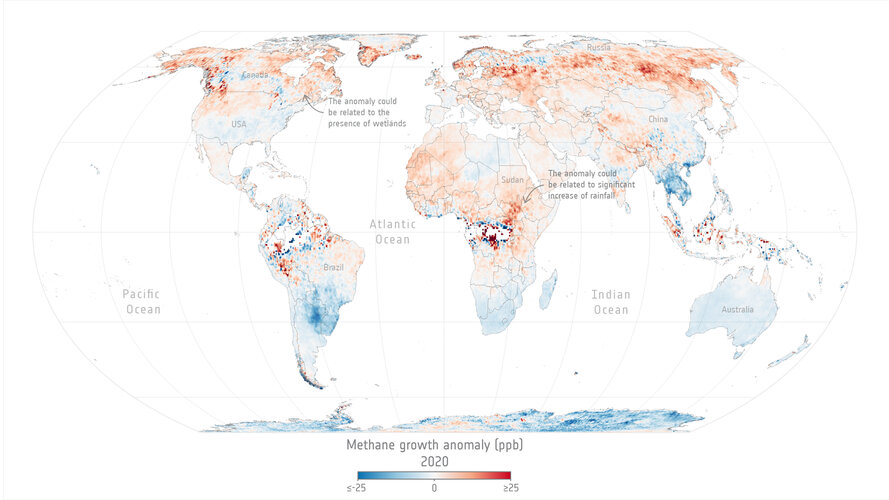
Levels of methane, the second most important greenhouse gas in our atmosphere, continued their unrelenting rise in 2020 despite the economic slowdown caused by the COVID-19 pandemic.
A team of scientists, from the University of Leeds, have used data from the Copernicus Sentinel-5P satellite to pinpoint locations with large surges of methane emissions. These findings were presented during ESA’s Living Planet Symposium which took place last month in Bonn, Germany.
Vrchní referent / rada – obnova katastrálního operátu v oddělení dokumentace KN Katastrálního pracov
23.6.2022 10:56 ČÚZK - volná místa Katastrální úřad pro Zlínský kraj Katastrální pracoviště Valašské Meziříčí vypisuje výběrové řízení na místo Vrchní referent / rada – obnova katastrálního operátu v oddělení dokumentace KN Katastrálního pracovVrchní referent / rada – obnova katastrálního operátu v oddělení dokumentace KN Katastrálního pracov
23.6.2022 10:56 ČÚZK - předpisy a opatření Katastrální úřad pro Zlínský kraj Katastrální pracoviště Valašské Meziříčívypisuje výběrové řízení na místo
Vrchní referent / rada – obnova katastrálního operátu v oddělení dokumentace KN Katastrálního pracoviště Valašské Meziříčí
Kartograf/ka
23.6.2022 10:16 Zeměměřický úřad Zeměměřický úřadvypisuje výběrové řízení na místo
Kartograf/ka
Kartograf/ka
23.6.2022 10:16 ČÚZK - volná místa Zeměměřický úřad vypisuje výběrové řízení na místo Kartograf/kaKartograf/ka
23.6.2022 10:16 ČÚZK - předpisy a opatření Zeměměřický úřadvypisuje výběrové řízení na místo
Kartograf/ka
Uživatelská konference Esri v San Diegu se blíží
23.6.2022 8:44 GISportal.cz
Jedna z největších GIS konferencí roku – uživatelská konference společnosti Esri v San Diegu se blíží a letos, více než kdy jindy, je i pro české účastníky možné se připojit, za malé (žádné) náklady. Věděli jste že: plenary (úvodní přednáška/y) je otevřená zdarma všem, stačí se zaregistrovat! plný online přístup je za 99 USD, což je […]
The post Uživatelská konference Esri v San Diegu se blíží appeared first on GISportal.cz.
Uživatelská konference Esri v San Diegu se blíží
23.6.2022 8:44 GISportal.czJedna z největších GIS konferencí roku – uživatelská konference společnosti Esri v San Diegu se blíží a letos, více než kdy jindy, je i pro české účastníky možné se připojit, za malé (žádné) náklady. Věděli jste že: plenary (úvodní přednáška/y) je otevřená zdarma všem, stačí se zaregistrovat! plný online přístup je za 99 USD, což je […]
The post Uživatelská konference Esri v San Diegu se blíží appeared first on GISportal.cz.
Regionálne stretnutie Trenčianskeho, Žilinského a Trnavského kraja
23.6.2022 0:00 Komora geodetů a kartografů SRAirspace Link completes a $23M Series B Round, led by Avanta Ventures, to accelerate the safe integration of drones
22.6.2022 22:44 GISCafe.com Webcasts-Webinars DETROIT, June 22, 2022 — (PRNewswire) — Airspace Link Inc, a leading provider of drone safety software and data solutions, announced the …Burgex Mining Consultants Launches Mineralocity Aggregates Interactive Map Tool
22.6.2022 17:19 GISCafe.com Webcasts-Webinars SALT LAKE CITY — (BUSINESS WIRE) — June 22, 2022 —Mineralocity Aggregates is finally live! After years of development, our …
CoreLogic Report: Nearly 33 Million and 7.8 Million U.S. Properties at Risk of Hurricane-force Wind and Storm Surge Damage, Respectively
22.6.2022 17:19 GISCafe.com Webcasts-Webinars New York City and Miami have most homes at risk of storm surge damage with the highest total reconstruction cost valueIRVINE, Calif. — …
Flogistix and Commaris Announce Collaborative Exploration
22.6.2022 17:19 GISCafe.com Webcasts-Webinars HOUSTON, June 22, 2022 — (PRNewswire) — Flogistix, LP and Commaris today announce that the companies are exploring combining their …Velodyne Lidar’s Intelligent Infrastructure Solution Deployed in Helsinki Traffic Safety Improvement Project
22.6.2022 16:14 GISCafe.com Webcasts-Webinars Velodyne’s Solution Delivered Traffic Monitoring with Lidar and Edge AI ComputingSAN JOSE, Calif. — (BUSINESS WIRE) — June 22, 2022 …
Hexagon disrupts reality capture once again with its next-generation, ultra-fast Leica BLK360 laser scanner
22.6.2022 16:14 GISCafe.com Webcasts-Webinars NACKA STRAND, Sweden, June 22, 2022 — (PRNewswire) — Hexagon AB, a global leader in digital reality solutions combining sensor, …BlackSky Chief Innovation Officer Dr. Patrick O’Neil to Present on AI and Machine Learning at AWS re:MARS 2022
22.6.2022 16:14 GISCafe.com Webcasts-Webinars Company to conduct live demonstrations of AI-enabled dynamic monitoring from spaceHERNDON, Va. — (BUSINESS WIRE) — June 22, 2022 …
Woolpert Expands Google Partnership Globally, Launches Support for Google Maps Platform in Europe, Middle East and Africa
22.6.2022 16:14 GISCafe.com Webcasts-Webinars AMSTERDAM, June 22, 2022 — (PRNewswire) — Woolpert announced today that it is expanding its partnership with Google to provide Google …ArcRevue 1/2022 je ke stažení
22.6.2022 12:42 ARCDATANejnovější číslo časopisu ArcRevue si můžete prohlédnout ve formátu PDF. Pojďte si přečíst články o projektech, jako je Atlas rozvoje venkova, Atlas Moravskoslezského kraje, Datový portál Královéhradeckého kraje nebo Informační systém „Přejímka Externích Zákresů“. Dozvíte se také, jak na data katastru a RÚIAN nebo jaké jsou novinky v oblasti zpracování rastrových dat.
Celý časopis ArcRevue si můžete stáhnout kliknutím na obrázek nebo si na stránce časopisu vyberte konkrétní článek.

20220622 - změny vyvolané zrušením okresu Praha
22.6.2022 11:42 ČÚZK /ruian/Novinky-RUIAN/Archiv-novinek-RUIAN/2022/20220622-zmeny-vyvolane-zrusenim-okresu-Praha20220622 - změny vyvolané zrušením okresu Praha
22.6.2022 11:30 ČÚZK /ruian/Poskytovani-udaju-ISUI-RUIAN-VDP/Vymenny-format-RUIAN-(VFR)/Archiv-novinek-VFR/2022/20220622-zmeny-vyvolane-zrusenim-okresu-PrahaHexagon, RapidSOS make life-saving data shareable across diverse organizations
22.6.2022 11:00 Hexagon Safety & Infrastructure Public safety tech leaders create safer, more resilient cities through enhanced situational awareness and information sharing3 hodiny konzultace zdarma při koupi nových strojařských produktů Autodesk
22.6.2022 10:28 Arkance SystemsArkance Systems vás nyní podpoří při koupi nové licence vybraných strojařských produktů. Platí až do 31.8. 2022.
Zpráva 3 hodiny konzultace zdarma při koupi nových strojařských produktů Autodesk pochází z arkance-systems.cz.
3 hodiny konzultace zdarma při koupi nových strojařských produktů Autodesk
22.6.2022 10:28 Arkance SystemsArkance Systems vás nyní podpoří při koupi nové licence vybraných strojírenských produktů. Platí až do 31.8. 2022.
Zpráva 3 hodiny konzultace zdarma při koupi nových strojařských produktů Autodesk pochází z arkance-systems.cz.
21 sLET olomoucké geoinformatiky
22.6.2022 10:08 Katedra geoinformatiky UP OlomoucKolegové, studenti, absolventi, prostě všichni olomoučtí geoinformatici, v září roku léta páně 2022 uplyne přesně 21 let od založení Katedry geoinformatiky na Univerzitě Palackého v Olomouci, se kterou jste spojili kus svého života. Někdo pracoval, někdo studoval, někdo ještě pracuje a někdo pořád ještě studuje. Za těch 21 let se mnoho změnilo nejenom na katedře, ale hlavně v oboru […]
The post 21 sLET olomoucké geoinformatiky appeared first on Katedra geoinformatiky.
Info k novele zákona o zeměměřictví
22.6.2022 9:49 ČÚZK - předpisy a opatření S účinností zákona č. 47/2020 Sb., kterým se mění mj. zákon č. 200/1994 Sb., o zeměměřictví a o změně a doplnění některých zákonů souvisejících s jeho zavedením, ve znění pozdějších předpisů, je od 1. července 2023 mezi zeměměřické činnosti ve veřejném zájmu nově zaváděno založení digitálních technických map a vyhotovení podkladů pro jejich vedení. Také tyto výsledky zeměměřických činností budou muset být ověřeny fyzickou osobou, které bylo uděleno úřední oprávnění pro ověřování výsledků zeměměřických činností, konkrétně rozsahem úředního oprávnění dle § 13 odst. 1 písm. c) výše uvedeného zákona. Potřebné informace k ověřování výsledků zeměměřických činností v elektronické podobě jsou na webových stránkách ČÚZK uvedeny v oddíle Zeměměřictví v záložce Zeměměřické činnosti. Naleznete zde také k volnému stažení software KDirSign, který je využitelný pro ověřování odborné správnosti výsledku v elektronické podobě.Slet olomouckých geoinformatiků, aneb 21 let od založení Katedry geoinformatiky v Olomouci
22.6.2022 9:33 GISportal.cz
V září roku léta páně 2022 uplyne přesně 21 let od založení Katedry geoinformatiky na Univerzitě Palackého v Olomouci a její vedení zve všechny bývalé studenty a zaměstnance na setkání. Níže zveřejňujeme jejich pozvánku. Pamatujete si na první kontakt s katedrou? Jak jste přijeli před lety na přijímačky nebo jaký byl první pracovní den na katedře? A […]
The post Slet olomouckých geoinformatiků, aneb 21 let od založení Katedry geoinformatiky v Olomouci appeared first on GISportal.cz.
Slet olomouckých geoinformatiků, aneb 21 let od založení Katedry geoinformatiky v Olomouci
22.6.2022 9:33 GISportal.czV září roku léta páně 2022 uplyne přesně 21 let od založení Katedry geoinformatiky na Univerzitě Palackého v Olomouci a její vedení zve všechny bývalé studenty a zaměstnance na setkání. Níže zveřejňujeme jejich pozvánku. Pamatujete si na první kontakt s katedrou? Jak jste přijeli před lety na přijímačky nebo jaký byl první pracovní den na katedře? A […]
The post Slet olomouckých geoinformatiků, aneb 21 let od založení Katedry geoinformatiky v Olomouci appeared first on GISportal.cz.
World ATM Congress v Madridu
22.6.2022 7:30 UAVATento týden probíhá největší světový veletrh a konference zaměřené na řízení letového provozu World ATM Congress v Madridu, kde nechybí ani prezident Aliance a další čeští vystavovatelé a účastníci. Velkým tématem je nyní U-Space a Urban Air Mobility. Je zde také možné potkat několik českých zástupců a vystavovatelů. Zde krátké video z akce:
The post World ATM Congress v Madridu appeared first on UAV Aliance pro bezpilotní letecký průmysl.
Better than Ever: CHASING's New Generation of Industrial-Grade Underwater Drone M2 PRO MAX Gets Easier-to-use, More Capabilities and Powerful Performance
22.6.2022 2:46 GISCafe.com Webcasts-Webinars QINGDAO, China, June 21, 2022 — (PRNewswire) — Chasing-Innovation Technology ("Chasing"), a world-leading developer and …APGEO - Valná hromada APG & konference Geomatika 2022
22.6.2022 2:00 Asociace podnikatelů v geomatice Valná hromada APG a konference Geomatika 2022 se bude konat v úterý 4. října 2022 ve vysočanském hotelu Clarion.Otevírací doba v červenci a srpnu [Knihovna geografie, byTopic]
22.6.2022 0:00 Katedra aplikované geoinformatiky a kartografie Přf UK Během prázdnin bude mít knihovna otevřeno každý den pouze od 9 do 11 hodin. Zkrácená otevírací doba souvisí s revizemi, které je knihovna provádět podle knihovního zákona. Děkujeme za pochopení a přejeme příjemné léto!Otevírací doba v červenci a srpnu [Knihovna geografie, byTopic]
22.6.2022 0:00 Katedra aplikované geoinformatiky a kartografie Přf UK Během prázdnin bude mít knihovna otevřeno každý den pouze od 9 do 11 hodin. Zkrácená otevírací doba souvisí s revizemi, které je knihovna povinna provádět podle knihovního zákona. Děkujeme za pochopení a přejeme příjemné léto!BlackSky Awarded Five-Year Joint Artificial Intelligence Center Contract for AI Data Readiness
21.6.2022 17:35 GISCafe.com Webcasts-Webinars Company’s data-rich dynamic monitoring platform delivers AI-enabled end-to-end capabilities for DoD communityHERNDON, Va. — (BUSINESS WIRE) …
Quectel Releases Dual-Band High Precision GNSS Module LC29H with RTK and DR Technologies
21.6.2022 17:35 GISCafe.com Webcasts-Webinars The LC29H series offers high performance, power-efficient solutions to meet market needs of high-precision positioning at the centimeter and …Smarty Unveils Unmatched QGIS Geocoding Accuracy with Release of Geocoding Plugin — US Address
21.6.2022 17:35 GISCafe.com Webcasts-Webinars PROVO, Utah — (BUSINESS WIRE) — June 21, 2022 —Smarty, a leader in location data intelligence, announces today the release of …
Leading Standards Organizations and Companies Unite to Drive Open Metaverse Interoperability
21.6.2022 17:35 GISCafe.com Webcasts-Webinars Metaverse Standards Forum to foster the development of open standards for the metaverse; Membership is free and open to any organization. Founding …AgEagle Announces eBee X™ is First Drone in its Class to Receive Design Verification Essential for BVLOS and Operations Over People From European Union Aviation Safety Agency
21.6.2022 17:35 GISCafe.com Webcasts-Webinars WICHITA, Kan., June 21, 2022 (GLOBE NEWSWIRE) -- AgEagle Aerial Systems Inc. (NYSE American: UAVS) (“AgEagle” or the “Company”), an …Orbbec Announces Availability of Femto Time-of-Flight Camera Line, Enabling Accurate 3D Object and Scene Capture
21.6.2022 17:35 GISCafe.com Webcasts-Webinars TROY, Mich., June 21, 2022 — (PRNewswire) — Orbbec, a leading global 3D camera provider, today announced it has begun shipping its line …Earth Observant Inc (EOI) Unveils Re-branding to Align with Company's Mission and Accelerated Growth
21.6.2022 17:35 GISCafe.com Webcasts-Webinars LOUISVILLE, Colo., June 21, 2022 — (PRNewswire) — EOI, a company deploying low-flying small satellites that provide location …NV5 Acquires GEO1, Expands National Leadership Position in Electrical Utility Geospatial Solutions
21.6.2022 17:35 GISCafe.com Webcasts-Webinars HOLLYWOOD, Fla., June 21, 2022 (GLOBE NEWSWIRE) -- NV5 Global, Inc. (the “Company” or “NV5”) (Nasdaq: NVEE), a provider of technology, …Esri Announces Winners of the 2022 ArcGIS Online Competition
21.6.2022 17:35 GISCafe.com Webcasts-Webinars US High School and Middle School Students Used GIS Technology to Map Home State IssuesREDLANDS, Calif. — (BUSINESS WIRE) — June 21, 2022 …
Drone Nerds to Highlight Public Safety UAV Solutions at the Police Security Expo 2022 in Atlantic City
21.6.2022 17:35 GISCafe.com Webcasts-Webinars Dania Beach, June 21, 2022 (GLOBE NEWSWIRE) -- Drone Nerds, an enterprise UAV solutions provider, will be at the largest law enforcement tradeshow …Nedostupné produkční prostředí ISÚI a VDP
21.6.2022 13:53 ČÚZK /ruian/Editacni-agendovy-system-ISUI/Provozni-informace-a-odstavky/Archiv-PROD/Nedostupne-produkcni-prostredi-ISUI-a-VDP-(3)Leica AP20 AutoPole
21.6.2022 10:53 GEFOS Leica AP20 AutoPole vám umožňuje měřit s nakloněnou tyčkou, přičemž automaticky zná její výšku a navíc vyhledá a uzamkne konkrétní hranol.Správa organizace na ArcGIS Online
21.6.2022 9:18 blog ARCDATA Pokud čtete tento článek, nejspíš zakládáte novou organizaci na ArcGIS Online a chcete být na správu organizace dobře připraven, nebo již administrátorem jste a hledáte postupy, které by vám práci s tímto prostředím usnadnily. V obou těchto případech byste v tomto článku měli nalézt upozornění na důležitá nastavení pro chod vaší organizace na ArcGIS Online.Hexagon and Fujitsu announce strategic partnership to solve societal challenges for ‘Trusted Society’
21.6.2022 4:00 Hexagon Safety & InfrastructureSichuan Road and Bridge Sets New Benchmark for Regional Smart Highways
20.6.2022 21:17 Bentley SystemsPressCoverage
TechInvest, ANZ
Read the articleodborný referent/vrchní referent – vedení katastrální mapy
20.6.2022 19:21 ČÚZK - předpisy a opatření Katastrální úřad pro hlavní město Prahuvypisuje výběrové řízení na místo
odborný referent/vrchní referent – vedení katastrální mapy
odborný referent/vrchní referent – vedení katastrální mapy
20.6.2022 19:21 ČÚZK /Urady/Katastralni-urady/Katastralni-urady/Katastralni-urad-pro-hlavni-mesto-Prahu/Uredni-deska/Oznameni-a-jina-uredni-sdeleni/Volna-mista/DMS/205-referent-vrchni-referent-–-vedeni-katastralniodborný referent/vrchní referent – vedení katastrální mapy
20.6.2022 19:21 ČÚZK - volná místa Katastrální úřad pro hlavní město Prahu vypisuje výběrové řízení na místo odborný referent/vrchní referent – vedení katastrální mapyodborný referent/vrchní referent – revize katastrálního operátu
20.6.2022 19:17 ČÚZK - předpisy a opatření Katastrální úřad pro hlavní město Prahuvypisuje výběrové řízení na místo
odborný referent/vrchní referent – revize katastrálního operátu
odborný referent/vrchní referent – revize katastrálního operátu
20.6.2022 19:17 ČÚZK - volná místa Katastrální úřad pro hlavní město Prahu vypisuje výběrové řízení na místo odborný referent/vrchní referent – revize katastrálního operátuodborný referent/vrchní referent – revize katastrálního operátu
20.6.2022 19:17 ČÚZK /Urady/Katastralni-urady/Katastralni-urady/Katastralni-urad-pro-hlavni-mesto-Prahu/Uredni-deska/Oznameni-a-jina-uredni-sdeleni/Volna-mista/DMS/204-referent-vrchni-referent-–-revize-katastralnihodborný referent/vrchní referent – pracovník podatelny
20.6.2022 19:14 ČÚZK - předpisy a opatření Katastrální úřad pro hlavní město Prahuvypisuje výběrové řízení na místo
odborný referent/vrchní referent – pracovník podatelny
odborný referent/vrchní referent – pracovník podatelny
20.6.2022 19:14 ČÚZK /Urady/Katastralni-urady/Katastralni-urady/Katastralni-urad-pro-hlavni-mesto-Prahu/Uredni-deska/Oznameni-a-jina-uredni-sdeleni/Volna-mista/DMS/203-odborny-referent-vrchni-referent-–-pracovnik-podborný referent/vrchní referent – pracovník podatelny
20.6.2022 19:14 ČÚZK - volná místa Katastrální úřad pro hlavní město Prahu vypisuje výběrové řízení na místo odborný referent/vrchní referent – pracovník podatelnyThe EUSPA Space Academy: Lift off to a successful space business!
20.6.2022 17:57 European GNSS Agency
Tired of the nine-to-five grind? Spacing out at your desk while thinking of launching your own start-up?
It’s time to stop dreaming, buckle up and get ready for lift off towards exciting opportunities in space!
The Space Academy, a new initiative by the EU Agency for the Space Programme (EUSPA), is your ticket to creating ground-breaking new apps and disruptive business solutions using the power of the EU Space Programme.
This free online training is open to all individuals, start-ups, entrepreneurs and SMEs who want to learn the ins and outs of building a space application business.
From innovative idea to successful space business
Your training starts with a series of modules that can be followed using your own device and completed when and where you want. The modules are taught by top academics, industry leaders and EUSPA experts, all of whom bring real-world experience to your learning journey.
By covering a specific topic or skill, these modules serve as building blocks for turning your innovative idea into a successful space business. Topics range from the technical details of the EU Space Programme and its various components to practical business skills such as:
• Customer support and sales
• Building a successful team
• Resource allocation
• Business plans and models
• Access to funding
• Intellectual Property, copyrights and data policy
• And much, much more
Pick and choose which modules to follow and tailor your training to your own unique learning needs. Opportunities for Q&As, one-on-one sessions, additional workshops, personalised follow-ups and mentoring may also be available. Once you finish the training, you’ll receive an official certificate of completion from EUSPA.
What are you waiting for? Subscribe to the EUSPA Space Academy today and then it’s 3, 2, 1 lift off to a successful space business!
Media note: This feature can be republished without charge provided the European Union Agency for the Space Programme (EUSPA) is acknowledged as the source at the top or the bottom of the story. You must request permission before you use any of the photographs on the site. If you republish, we would be grateful if you could link back to the EUSPA website (http://www.euspa.europa.eu).
Registrace subjektů do VR DMVS
20.6.2022 16:31 ČÚZK - předpisy a opatření Dne 16. června 2022 byl na všechny obce v rámci první vlny oslovování subjektů dopravní a technické infrastruktury rozeslán průvodní dopis s žádostí o registraci do Verifikačního registru DMVS. Součástí registrace je kontrola údajů, které o konkrétním subjektu ČÚZK získal z veřejných evidencí, doplnění rolí, ve kterých bude subjekt v rámci ID DMVS vystupovat, a doplnění skupiny objektů, které subjekt vlastní nebo spravuje. V případě problémů s procesem registrace je možno ČÚZK kontaktovat také na e-mailové adrese vr.dmvs@cuzk.cz.Tantek 4D manages construction of tallest modular-built high-rise in the world
20.6.2022 16:12 Bentley SystemsPressCoverage
Inside Construction, ANZ
Read the articleProStar Expands Into Australia With The Adoption Of PointMan By Utility Mapping
20.6.2022 16:05 GISCafe.com Webcasts-Webinars GRAND JUNCTION, Colo., June 20, 2022 (GLOBE NEWSWIRE) -- ProStar Holdings Inc. ("ProStar®" or "the Company") (TSXV: MAPS) (OTCQX: MAPPF) (FSE: …City of Helsinki Expands Digitalization with Citywide Digital Twin
20.6.2022 15:59 Bentley SystemsPressCoverage
Engineering.com, USA
Read the articleInfrastructure Investment and Jobs Act Brings Digital Construction to DOTs
20.6.2022 15:51 Bentley SystemsPressCoverage
Engineering.com, USA
Read the articleDigital Twins and the Gemini Papers
20.6.2022 15:40 Bentley SystemsPressCoverage
dc hub, UK&I
Read the articleSlavnostní vyhlášení výsledků soutěže Mapa roku
20.6.2022 13:45 Česká kartografická společnostSlavnostní vyhlášení výsledků soutěže proběhlo ve čtvrtek 9. června 2022 v sídle Českého úřadu zeměměřického a katastrálního v Praze. Součástí slavnostního předání ocenění Mapa roku 2021 bylo také přání k 90. narozeninám významnému českému kartografovi doc. Ing. Miroslavu Mikšovskému, CSc., a udělení čestného členství v České kartografické společnosti historičce prof. PhDr. Evě Semotanové, DrSc. Více informací na stránkách soutěže.
The post Slavnostní vyhlášení výsledků soutěže Mapa roku first appeared on Česká kartografická společnost.
Slavnostní vyhlášení výsledků soutěže Mapa roku
20.6.2022 13:45 Česká kartografická společnost Slavnostní vyhlášení výsledků soutěže proběhlo ve čtvrtek 9. června 2022 v sídle Českého úřadu zeměměřického a katastrálního v Praze. Součástí slavnostního předání ocenění Mapa roku 2021 bylo také přání k 90. narozeninám významnému českému kartografovi doc. Ing. Miroslavu Mikšovskému, CSc., a udělení čestného členství v České kartografické společnosti historičce prof. PhDr. Evě Semotanové, DrSc. Více informací na stránkách soutěže.ArcČR 4.1 je ke stažení (i pro ne Esri uživatele)
20.6.2022 12:33 GISportal.cz
Digitální vektorová databáze České republiky ArcČR® verze 4.1 obsahuje data administrativního členění České republiky propojená s vybranými statistickými údaji Českého statistického úřadu ze Sčítání lidu, domů a bytů. Zdrojem geometrie dat jsou data z RÚIAN (Registru územní identifikace, adres a nemovitostí) exportovaná k 10. 2. 2022. Vrstvy obcí, okresů a krajů jsou navíc doplněny o statistiky Územně analytických podkladů (ÚAP), např. o počet obyvatel v různých […]
The post ArcČR 4.1 je ke stažení (i pro ne Esri uživatele) appeared first on GISportal.cz.
ArcČR 4.1 je ke stažení (i pro ne Esri uživatele)
20.6.2022 12:33 GISportal.czDigitální vektorová databáze České republiky ArcČR® verze 4.1 obsahuje data administrativního členění České republiky propojená s vybranými statistickými údaji Českého statistického úřadu ze Sčítání lidu, domů a bytů. Zdrojem geometrie dat jsou data z RÚIAN (Registru územní identifikace, adres a nemovitostí) exportovaná k 10. 2. 2022. Vrstvy obcí, okresů a krajů jsou navíc doplněny o statistiky Územně analytických podkladů (ÚAP), např. o počet obyvatel v různých […]
The post ArcČR 4.1 je ke stažení (i pro ne Esri uživatele) appeared first on GISportal.cz.
20220620_Vrchní referent / rada personálního oddělení Katastrálního úřadu
20.6.2022 11:21 ČÚZK /Urady/Katastralni-urady/Katastralni-urady/Katastralni-urad-pro-Stredocesky-kraj/O-uradu/Aktuality/20210922_Odborny-referent-oddeleni-aktualizace-(7)20220620_Vrchní referent / rada personálního oddělení Katastrálního úřadu
20.6.2022 11:21 ČÚZK - předpisy a opatření Katastrální úřad pro Středočeský kraj Vyhlášení výběrového řízení: Vrchní referent / rada personálního oddělení Katastrálního úřadu V části "Úřední deska", v sekci "Oznámení a jiná úřední sdělení" bylo vystaveno "Oznámení o vyhlášení výběrového řízení na obsazení služebního místa Vrchní referent / rada personálního oddělení Katastrálního úřadu"20220531_Vrchní referent / rada personálního oddělení Katastrálního úřadu
20.6.2022 11:21 ČÚZK /Urady/Katastralni-urady/Katastralni-urady/Katastralni-urad-pro-Stredocesky-kraj/O-uradu/Aktuality/20210922_Odborny-referent-oddeleni-aktualizace-(7)20220531_Vrchní referent / rada personálního oddělení Katastrálního úřadu
20.6.2022 11:21 ČÚZK - předpisy a opatření Katastrální úřad pro Středočeský kraj Vyhlášení výběrového řízení: Vrchní referent / rada personálního oddělení Katastrálního úřadu V části "Úřední deska", v sekci "Oznámení a jiná úřední sdělení" bylo vystaveno "Oznámení o vyhlášení výběrového řízení na obsazení služebního místa Vrchní referent / rada personálního oddělení Katastrálního úřadu"Vrchní referent / rada personálního oddělení Katastrálního úřadu
20.6.2022 11:18 ČÚZK - volná místa Katastrální úrad pro Středočeský kraj vypisuje výběrové řízení na místo Vrchní referent / rada personálního oddělení Katastrálního úřaduVrchní referent / rada personálního oddělení Katastrálního úřadu
20.6.2022 11:18 ČÚZK /Urady/Katastralni-urady/Katastralni-urady/Katastralni-urad-pro-Stredocesky-kraj/Uredni-deska/Oznameni-a-jina-uredni-sdeleni/Volna-mista/DMS/Vrchni-referent-rada-personalniho-oddeleni-KatasVrchní referent / rada personálního oddělení Katastrálního úřadu
20.6.2022 11:18 ČÚZK - předpisy a opatření Katastrální úrad pro Středočeský krajvypisuje výběrové řízení na místo
Vrchní referent / rada personálního oddělení Katastrálního úřadu
Space tech to be put to test on Asia-bound Fiat Panda
20.6.2022 10:47 ESA Navigation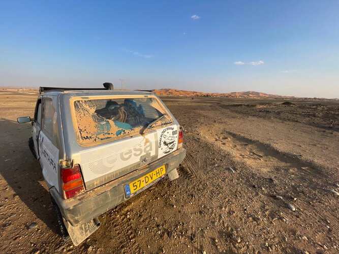
Two ESA engineers are offering a unique testbed for novel space technology: a second-hand, two-decade-old Fiat Panda, set to be driven 16 000 km to compete in the Mongol Rally from Europe to the Mongolian steppes during summer 2023. Having already taken part in the Panda Raid race to Morocco and back, the ‘space2ground’ team plans to perform on-board testing over the course of their epic Asiatic drive.
odborný referent/vrchní referent – oddělení aktualizace katastru nemovitostí
20.6.2022 10:40 ČÚZK /Urady/Katastralni-urady/Katastralni-urady/Katastralni-urad-pro-Karlovarsky-kraj/Uredni-deska/Oznameni-a-jina-uredni-sdeleni/Volna-mista/DMS/odborny-referent-vrchni-referent-–-oddeleni-aktualodborný referent/vrchní referent – oddělení aktualizace katastru nemovitostí
20.6.2022 10:40 ČÚZK - volná místa Katastrální úřad pro Karlovarský kraj Katastrální pracoviště Karlovy Vary vypisuje výběrové řízení na místo odborný referent/vrchní referent – oddělení aktualizace katastru nemovitostíodborný referent/vrchní referent – oddělení aktualizace katastru nemovitostí
20.6.2022 10:40 ČÚZK - předpisy a opatření Katastrální úřad pro Karlovarský kraj Katastrální pracoviště Karlovy Varyvypisuje výběrové řízení na místo
odborný referent/vrchní referent – oddělení aktualizace katastru nemovitostí
Vrchní referent/rada – obnova katastrálního operátu na Katastrálním pracovišti Ostrava
20.6.2022 8:33 ČÚZK - volná místa Katastrální úřad pro Moravskoslezský kraj Katastrální pracoviště Ostrava vypisuje výběrové řízení na místo Vrchní referent/rada – obnova katastrálního operátu na Katastrálním pracovišti OstravaVrchní referent/rada – obnova katastrálního operátu na Katastrálním pracovišti Ostrava
20.6.2022 8:33 ČÚZK /Urady/Katastralni-urady/Katastralni-urady/Katastralni-urad-pro-Moravskoslezsky-kraj/Uredni-deska/Oznameni-a-jina-uredni-sdeleni/Volna-mista/DMS/Vrchni-referent-rada-–-obnova-katastralniho-op-(1)Vrchní referent/rada – obnova katastrálního operátu na Katastrálním pracovišti Ostrava
20.6.2022 8:33 ČÚZK - předpisy a opatření Katastrální úřad pro Moravskoslezský kraj Katastrální pracoviště Ostravavypisuje výběrové řízení na místo
Vrchní referent/rada – obnova katastrálního operátu na Katastrálním pracovišti Ostrava
Vrchní referent/rada – obnova katastrálního operátu
20.6.2022 8:27 ČÚZK - volná místa Katastrální úřad pro Moravskoslezský kraj Katastrální pracoviště Frýdek-Místek vypisuje výběrové řízení na místo Vrchní referent/rada – obnova katastrálního operátuVrchní referent/rada – obnova katastrálního operátu
20.6.2022 8:27 ČÚZK - předpisy a opatření Katastrální úřad pro Moravskoslezský kraj Katastrální pracoviště Frýdek-Místekvypisuje výběrové řízení na místo
Vrchní referent/rada – obnova katastrálního operátu
Rada/odborný rada – rozhodování o povolení vkladu
20.6.2022 8:23 ČÚZK /Urady/Katastralni-urady/Katastralni-urady/Katastralni-urad-pro-Moravskoslezsky-kraj/Uredni-deska/Oznameni-a-jina-uredni-sdeleni/Volna-mista/DMS/Rada-odborny-rada-–-rozhodovani-o-povoleni-vkladuRada/odborný rada – rozhodování o povolení vkladu
20.6.2022 8:23 ČÚZK - předpisy a opatření Katastrální úřad pro Moravskoslezský kraj Katastrální pracoviště Frýdek-Místekvypisuje výběrové řízení na místo
Rada/odborný rada – rozhodování o povolení vkladu
Rada/odborný rada – rozhodování o povolení vkladu
20.6.2022 8:23 ČÚZK - volná místa Katastrální úřad pro Moravskoslezský kraj Katastrální pracoviště Frýdek-Místek vypisuje výběrové řízení na místo Rada/odborný rada – rozhodování o povolení vkladuAplikace Holixa T4R vydána s podporou pro Revit 2023
20.6.2022 8:00 Arkance SystemsTento týden vydáváme novou verzi nadstavbové aplikace Holixa T4R (dříve známé jako Revit Tools) s podporou pro Autodesk Revit® 2023.
Zpráva Aplikace Holixa T4R vydána s podporou pro Revit 2023 pochází z arkance-systems.cz.
Aliance zařídíla český stánek na největším evropském veletrhu Amsterdam Drone Week 2022 s EASA High Level Conference
19.6.2022 15:12 UAVATento týden nechybíme na Amsterdam Drone Week 2022 s EASA High Level Conference na Českém stánku, který Aliance zařídila ve spolupráci s českým velvyslanectvím v Nizozemsku, kde nás dnes navštívila i paní velvyslankyně v Nizozemsku. Na stánku jste mohli potkat UpVision, Dronetag, Workswell , Fly4future a BizGarden sro. Není nad potkávání se a jednání osobně […]
The post Aliance zařídíla český stánek na největším evropském veletrhu Amsterdam Drone Week 2022 s EASA High Level Conference appeared first on UAV Aliance pro bezpilotní letecký průmysl.
Aliance je opět partnerem Commercial UAV Expo Americas 2022 v Las Vegas a bude zde opět český stánek
19.6.2022 7:10 UAVAAliance je opět partnerem jedné z největších světových akcí zaměřené na drony Commercial UAV Expo Americas, která se koná 6. – 8. září 2022 v Las Vegas, kde bude také český stánek a pro případné další zájemce kromě vystavovatelů máme k dispozici 2 lístky zdarma na celou třídenní akci v ceně až $950, včetně konference […]
The post Aliance je opět partnerem Commercial UAV Expo Americas 2022 v Las Vegas a bude zde opět český stánek appeared first on UAV Aliance pro bezpilotní letecký průmysl.
Výběrové řízení na studijní pobyty v rámci programu Erasmus+ (jaro 2023)
19.6.2022 0:00 Geografický ústav MUDo 19. června 2022 probíhá na GÚ výběrové řízení na studijní pobyty Erasmus+ na období jaro 2023. Přihlášky se podávají prostřednictvím systému ISOIS isois.ois.muni.cz/en/outgoing-application/application/.
Detaily k výběrovému řízení naleznete zde.
Výběrové řízení na studijní pobyty v rámci programu Erasmus+ (jaro 2023)
19.6.2022 0:00 Geografický ústav MUDo 19. června 2022 probíhá na GÚ výběrové řízení na studijní pobyty Erasmus+ pro období jaro 2023. Přihlášky se podávají prostřednictvím systému ISOIS isois.ois.muni.cz/en/outgoing-application/application/.
Detaily k výběrovému řízení naleznete zde.
Nová verze DAEX DESIGN Plus 23
18.6.2022 20:25 ŠPINAR - softwareVážení zákazníci,
nová verze DAEX DESIGN Plus 23 CZ již na trhu České a Slovenské republiky.
The post Nová verze DAEX DESIGN Plus 23 appeared first on ŠPINAR – software.
Nová verze DAEX DESIGN Plus 23
18.6.2022 20:25 ŠPINAR - softwareVážení zákazníci,
nová verze DAEX DESIGN Professional 23 CZ již na trhu České a Slovenské republiky.
The post Nová verze DAEX DESIGN Plus 23 appeared first on ŠPINAR – software.
Nová verze DAEX DESIGN Plus 23
18.6.2022 20:25 ŠPINAR - software Vážení zákazníci,nová verze DAEX DESIGN Plus 23 CZ již na trhu České a Slovenské republiky.
TurbineHub Joins the Esri Startup Program
17.6.2022 18:19 GISCafe.com Webcasts-Webinars Bringing a New Standard to Wind Energy Development and InvestmentAVON, Colo. — (BUSINESS WIRE) — June 16, 2022 …
2022 Safety and Security Summit @ Esri UC to Showcase Building Resilient Communities
17.6.2022 18:19 GISCafe.com Webcasts-Webinars Industry Leaders Will Discuss Risk and How GIS Can Help Plan for a Safer FutureREDLANDS, Calif. — (BUSINESS WIRE) — June 17, 2022 …
V Unicornu proběhl GIS Day 2022
17.6.2022 15:00 Unicorn Dne 14. 6. 2022 proběhl odborný seminář Unicorn GIS Day na téma aktuálních trendů geografických informačních systémů (GIS), kde jsme se podělili o naše pracovní zkušenosti z oboru. Věnovali jsme se zejména tématům výkonné spolupráce na projektech a efektivním využití dostupných geoinformatických nástrojů. Řekli jsme si o roli GIS v oblasti BIM, provozu GIS systémů v cloudu, novinkách v technologiích Esri a mnoha dalším. Přečtěte si o čem seminář byl a pusťte si záznam!20220617 - VŘ Řízení projektů - RÚIAN
17.6.2022 13:40 ČÚZK /Aktuality-resort/2022/20220617-VR-Rizeni-projektu-RUIAN20220617 - VŘ Řízení projektů - RÚIAN
17.6.2022 13:40 ČÚZK - předpisy a opatření Český úřad zeměměřický a katastrální zveřejnil novou aktualitu: Oznámení o vyhlášení výběrového řízení na obsazení služebního místa Řízení projektů - RÚIAN.20220617 - VŘ Řízení projektů - RÚIAN
17.6.2022 13:40 ČÚZK - aktuality v resortu Oznámení o vyhlášení výběrového řízení na obsazení služebního místa Řízení projektů - RÚIAN.Řízení projektů - RÚIAN
17.6.2022 13:32 ČÚZK /Urady/Cesky-urad-zememericky-a-katastralni/Uredni-deska/Oznameni-a-jina-uredni-sdeleni/Volna-mista/DMS/Rizeni-projektu-RUIANŘízení projektů - RÚIAN
17.6.2022 13:32 ČÚZK - předpisy a opatření Český úřad zeměměřický a katastrálnívypisuje výběrové řízení na místo
Řízení projektů - RÚIAN
Řízení projektů - RÚIAN
17.6.2022 13:32 ČÚZK - volná místa Český úřad zeměměřický a katastrální vypisuje výběrové řízení na místo Řízení projektů - RÚIANVŘ - Technický odbor - obnova katastrálního operátu
17.6.2022 13:05 ČÚZK - předpisy a opatření Katastrální úřad pro Olomoucký kraj - technický odborvypisuje výběrové řízení na místo
VŘ - Technický odbor - obnova katastrálního operátu