


![]()

zprávy
zdroje zpráv:Novinky v aplikacích
29.6.2022 11:00 ČÚZK - Geoportál Novinky v aplikacíchGeoprohlížeč:
Produkty DMR 5G, DMR 4G a DMP 1G jsou nově zobrazovány pomocí Image služby - připravené rastrové funkce jsou po přidání do Seznamu vrstev k dispozici v kontextovém menu vrstvy.
Externí Image služby je nyní možné připojit ve widgetu Přidat data - REST. K dispozici je nastavení rastrových služeb, které jsou zohledněny i při sdílení Geoprohlížeče (uložení webové mapy).
Archiv:
Byly doplněny nejnovější letecké měřické snímky z roku 1975.
Analýzy výškopisu:
Byly doplněny příslušné nápovědy do každého widgetu.
Jména světa:
Byl doplněn francouzský překlad.
Novinky v aplikacích
29.6.2022 11:00 ČÚZK - Geoportál Novinky v aplikacíchGeoprohlížeč:
Produkty DMR 5G, DMR 4G a DMP 1G jsou nově zobrazovány pomocí Image služby - připravené rastrové funkce jsou po přidání do Seznamu vrstev k dispozici v kontextovém menu vrstvy.
Externí Image služby je nyní možné připojit ve widgetu Přidat data - REST. K dispozici je nastavení rastrových služeb, které jsou zohledněny i při sdílení Geoprohlížeče (uložení webové mapy).
Archiv:
Byly doplněny nejnovější letecké měřické snímky z roku 1975.
Analýzy výškopisu:
Byly doplněny příslušné nápovědy do každého widgetu.
Jména světa:
Byl doplněn francouzský překlad.
výběrové řízení na KP Žďár nad Sázavou
29.6.2022 9:42 ČÚZK - předpisy a opatření Katastrální úřad pro Vysočinu - Katastrální pracoviště Žďár nad Sázavou zveřejnil novou aktualitu: Oznámení o vyhlášení výběrového řízení na služební místo odborný referent/vrchní referent v oddělení právní vztahy k nemovitostem Katastrálního pracoviště Žďár nad Sázavou.výběrové řízení na KP Žďár nad Sázavou
29.6.2022 9:42 ČÚZK /Urady/Katastralni-urady/Katastralni-urady/Katastralni-urad-pro-Vysocinu/O-uradu/Aktuality/vyberove-rizeni-na-KP-Zdar-nad-Sazavou-(2)odborný-vrchní referent - právní vztahy KP Žďár n. S.
29.6.2022 9:27 ČÚZK /Urady/Katastralni-urady/Katastralni-urady/Katastralni-urad-pro-Vysocinu/Uredni-deska/Oznameni-a-jina-uredni-sdeleni/Volna-mista/DMS/odborny-vrchni-referent-pravni-vztahy-KP-Zdar-nodborný-vrchní referent - právní vztahy KP Žďár n. S.
29.6.2022 9:27 ČÚZK - volná místa Katastrální úřad pro Vysočinu Katastrální pracoviště Žďár nad Sázavou vypisuje výběrové řízení na místo odborný-vrchní referent - právní vztahy KP Žďár n. S.odborný-vrchní referent - právní vztahy KP Žďár n. S.
29.6.2022 9:27 ČÚZK - předpisy a opatření Katastrální úřad pro Vysočinu Katastrální pracoviště Žďár nad Sázavouvypisuje výběrové řízení na místo
odborný-vrchní referent - právní vztahy KP Žďár n. S.
Referent/ka zeměměřictví a katastru nemovitostí
29.6.2022 9:07 Zeměměřický úřad Zeměměřický úřadvypisuje výběrové řízení na místo
Referent/ka zeměměřictví a katastru nemovitostí
Referent/ka zeměměřictví a katastru nemovitostí
29.6.2022 9:07 ČÚZK - volná místa Zeměměřický úřad vypisuje výběrové řízení na místo Referent/ka zeměměřictví a katastru nemovitostíReferent/ka zeměměřictví a katastru nemovitostí
29.6.2022 9:07 ČÚZK /Urady/Zememericky-urad/Volna-mista/DMS/Referent-ka-zememerictvi-a-katastru-nemovitostiReferent/ka zeměměřictví a katastru nemovitostí
29.6.2022 9:07 ČÚZK - předpisy a opatření Zeměměřický úřadvypisuje výběrové řízení na místo
Referent/ka zeměměřictví a katastru nemovitostí
Nové letecké snímky v aplikaci Archiv
29.6.2022 9:05 ČÚZK - Geoportál Nové letecké snímky v aplikaci ArchivAplikace Archiv byla doplněna o nově naskenované archivní letecké měřické snímky z roku 1975.
Nové letecké snímky v aplikaci Archiv
29.6.2022 9:05 ČÚZK - Geoportál Nové letecké snímky v aplikaci ArchivAplikace Archiv byla doplněna o nově naskenované archivní letecké měřické snímky z roku 1975.
Nové letecké snímky v aplikaci Archiv
29.6.2022 9:05 ČÚZK - Geoportál Nové letecké snímky v aplikaci ArchivAplikace Archiv byla doplněna o nově naskenované archivní letecké měřické snímky z roku 1975.
Nové letecké snímky v aplikaci Archiv
29.6.2022 9:05 ČÚZK - Geoportál Nové letecké snímky v aplikaci ArchivAplikace Archiv byla doplněna o nově naskenované archivní letecké měřické snímky z roku 1975.
Nové letecké snímky v aplikaci Archiv
29.6.2022 9:05 ČÚZK - Geoportál Nové letecké snímky v aplikaci ArchivAplikace Archiv byla doplněna o nově naskenované archivní letecké měřické snímky z roku 1975.
Nové letecké snímky v aplikaci Archiv
29.6.2022 9:05 ČÚZK - Geoportál Nové letecké snímky v aplikaci ArchivAplikace Archiv byla doplněna o nově naskenované archivní letecké měřické snímky z roku 1975.
Nové letecké snímky v aplikaci Archiv
29.6.2022 9:05 ČÚZK - Geoportál Nové letecké snímky v aplikaci ArchivAplikace Archiv byla doplněna o nově naskenované archivní letecké měřické snímky z roku 1975.
Nové letecké snímky v aplikaci Archiv
29.6.2022 9:05 ČÚZK - Geoportál Nové letecké snímky v aplikaci ArchivAplikace Archiv byla doplněna o nově naskenované archivní letecké měřické snímky z roku 1975.
Nové letecké snímky v aplikaci Archiv
29.6.2022 9:05 ČÚZK - Geoportál Nové letecké snímky v aplikaci ArchivAplikace Archiv byla doplněna o nově naskenované archivní letecké měřické snímky z roku 1975.
Nové letecké snímky v aplikaci Archiv
29.6.2022 9:05 ČÚZK - Geoportál Nové letecké snímky v aplikaci ArchivAplikace Archiv byla doplněna o nově naskenované archivní letecké měřické snímky z roku 1975.
Nové letecké snímky v aplikaci Archiv
29.6.2022 9:05 ČÚZK - Geoportál Nové letecké snímky v aplikaci ArchivAplikace Archiv byla doplněna o nově naskenované archivní letecké měřické snímky z roku 1975.
Nové letecké snímky v aplikaci Archiv
29.6.2022 9:05 ČÚZK - Geoportál Nové letecké snímky v aplikaci ArchivAplikace Archiv byla doplněna o nově naskenované archivní letecké měřické snímky z roku 1975.
Nové letecké snímky v aplikaci Archiv
29.6.2022 9:05 ČÚZK - Geoportál Nové letecké snímky v aplikaci ArchivAplikace Archiv byla doplněna o nově naskenované archivní letecké měřické snímky z roku 1975.
Nové letecké snímky v aplikaci Archiv
29.6.2022 9:05 ČÚZK - Geoportál Nové letecké snímky v aplikaci ArchivAplikace Archiv byla doplněna o nově naskenované archivní letecké měřické snímky z roku 1975.
Nové letecké snímky v aplikaci Archiv
29.6.2022 9:05 ČÚZK - Geoportál Nové letecké snímky v aplikaci ArchivAplikace Archiv byla doplněna o nově naskenované archivní letecké měřické snímky z roku 1975.
Nové letecké snímky v aplikaci Archiv
29.6.2022 9:05 ČÚZK - Geoportál Nové letecké snímky v aplikaci ArchivAplikace Archiv byla doplněna o nově naskenované archivní letecké měřické snímky z roku 1975.
Nové letecké snímky v aplikaci Archiv
29.6.2022 9:05 ČÚZK - Geoportál Nové letecké snímky v aplikaci ArchivAplikace Archiv byla doplněna o nově naskenované archivní letecké měřické snímky z roku 1975.
Nové letecké snímky v aplikaci Archiv
29.6.2022 9:05 ČÚZK - Geoportál Nové letecké snímky v aplikaci ArchivAplikace Archiv byla doplněna o nově naskenované archivní letecké měřické snímky z roku 1975.
Nové letecké snímky v aplikaci Archiv
29.6.2022 9:05 ČÚZK - Geoportál Nové letecké snímky v aplikaci ArchivAplikace Archiv byla doplněna o nově naskenované archivní letecké měřické snímky z roku 1975.
Vyhlášení platnosti obnoveného operátu
29.6.2022 8:49 ČÚZK - předpisy a opatření Katastrální úřad pro Liberecký kraj - Katastrální pracoviště Semily zveřejnil novou aktualitu: Dne 28. 6. 2022 byla v kat. území Vyskeř vyhlášena platnost obnoveného katastrálního operátu novým mapováním na části katastrálního území.Vyhlášení platnosti obnoveného operátu
29.6.2022 8:49 ČÚZK /Urady/Katastralni-urady/Katastralni-urady/Katastralni-urad-pro-Liberecky-kraj/Katastralni-pracoviste/KP-Semily/O-uradu/Aktuality/Vyhlaseni-platnosti-obnoveneho-operatuVýpadek telefonní ústředny
29.6.2022 8:32 ČÚZK - předpisy a opatření Katastrální úřad pro Středočeský kraj - Katastrální pracoviště Rakovníkzveřejnil novou aktualitu: KP Rakovník má z technických důvodů výpadek telefonní ústředny. Na nápravě se pracuje.
Výpadek telefonní ústředny
29.6.2022 8:32 ČÚZK - předpisy a opatření Katastrální úřad pro Středočeský kraj - Katastrální pracoviště Rakovník zveřejnil novou aktualitu: KP Rakovník má z technických důvodů výpadek telefonní ústředny. Na nápravě se pracuje.Nouzové kontaktní číslo: 737 228 763
Výpadek telefonní ústředny
29.6.2022 8:32 ČÚZK /Urady/Katastralni-urady/Katastralni-urady/Katastralni-urad-pro-Stredocesky-kraj/Katastralni-pracoviste/KP-Rakovnik/O-uradu/Aktuality/Vypadek-telefonni-ustrednyAeroVironment Announces Fiscal 2022 Fourth Quarter and Fiscal Year Results
29.6.2022 1:47 GISCafe.com Webcasts-Webinars ARLINGTON, Va. — (BUSINESS WIRE) — June 28, 2022 —AeroVironment, Inc. (NASDAQ: AVAV), a global leader in intelligent, …
Taking off with Liebherr electronics: high-tech drones by Quantum-Systems
29.6.2022 0:22 GISCafe.com Webcasts-Webinars Drone manufacturer Quantum-Systems relies on Liebherr’s experience, when it comes to the manufacturing of electronics for the autopilot and …Airbus awarded FORUM Earth monitoring satellite contract from ESA
29.6.2022 0:09 GISCafe.com Webcasts-Webinars Stevenage, 28 June 2022 - Airbus has been awarded a €160M contract for the European Space Agency’s (ESA) FORUM satellite to measure heat …Svět knihy '22 a nové přírůstky do knihovny [Knihovna geografie, byTopic]
29.6.2022 0:00 Katedra aplikované geoinformatiky a kartografie Přf UK Představujeme Vám výběr knih, nakoupených na veletrhu Svět knihy 2022. Postupně je zpracováváme tak, abyste si je mohli co nejdříve půjčit. Zastavte se u nás! :-)S&P CORELOGIC CASE-SHILLER INDEX REPORTS ANNUAL HOME PRICE GAIN OF 20.4%
28.6.2022 18:58 GISCafe.com Webcasts-Webinars NEW YORK, June 28, 2022 — (PRNewswire) — S&P Dow Jones Indices (S&P DJI) today released the latest results for the S&P …Bantec's Drone USA Receives Purchase Order from a State Police Department for two Ultra-High-Tech Drones Equipped with Lidar and Night Vision Capabilities.
28.6.2022 18:58 GISCafe.com Webcasts-Webinars LITTLE FALLS, N.J., June 28, 2022 — (PRNewswire) — Bantec, Inc. (OTCPINK: BANT) ("Bantec" or the "Company"), Bantec, Inc., a …Nation's First Drone-on-Demand Mobile App Now Downloadable on All Devices
28.6.2022 18:58 GISCafe.com Webcasts-Webinars HARTFORD, Conn., June 28, 2022 — (PRNewswire) —Aquiline Drones Creates Streamlined Drone Ordering System for Consumer & …
Digital Twinning
28.6.2022 16:22 Bentley SystemsPressCoverage
Airports International, UK&I
Read the articleCartegraph Launches Right-of-Way Permitting Solution for Local Governments
28.6.2022 16:21 GISCafe.com Webcasts-Webinars Affordable SaaS solution streamlines ROW permitting workflows, from application and review to payment processing and issuance.DUBUQUE, Iowa — …
Cardinal Health, Magellan Rx Management, and Novant Health Launch On-Demand Drone Delivery with Zipline
28.6.2022 16:21 GISCafe.com Webcasts-Webinars KANNAPOLIS, N.C., June 28, 2022 (GLOBE NEWSWIRE) -- North Carolina’s legacy of first in flight is now even richer. Three leading U.S. healthcare …Overhead Intelligence Partners with Iris Automation for Large-Scale Magnetometer Survey
28.6.2022 16:21 GISCafe.com Webcasts-Webinars WINTER HAVEN, Fla. and RENO, Nev., June 28, 2022 — (PRNewswire) — Working with safety innovator Iris Automation, Florida-based …Gordie Howe
28.6.2022 16:09 Bentley SystemsPressCoverage
Civil Engineering Surveyor, UK&I
Read the articleMapová aplikace ÚPD - nové dokumentace
28.6.2022 14:53 Jihočeský krajV mapové aplikaci Územně plánovací dokumentace obcí byla aktualizována ÚPD obcí ORP České Budějovice – Hrdějovice, ORP Trhové Sviny – Slavče, Mladošovice, Olešnice, Jílovice, ORP Český Krumlov – Český Krumlov a ORP Dačice – Hříšice.
20220628_Odborný referent oddělení právních vztahů k nemovitostem
28.6.2022 11:16 ČÚZK /Urady/Katastralni-urady/Katastralni-urady/Katastralni-urad-pro-Stredocesky-kraj/Katastralni-pracoviste/KP-Pribram/O-uradu/Aktuality/20210922_Odborny-referent-oddeleni-aktualizace-(2)20220628_Odborný referent oddělení právních vztahů k nemovitostem
28.6.2022 11:16 ČÚZK - předpisy a opatření Katastrální úřad pro Středočeský kraj - Katastrální pracoviště Příbram Vyhlášení výběrového řízení: Odborný referent oddělení právních vztahů k nemovitostem V části "Úřední deska", v sekci "Oznámení a jiná úřední sdělení" bylo vystaveno "Oznámení o vyhlášení výběrového řízení na obsazení služebního místa Odborný referent oddělení právních vztahů k nemovitostem"Odborný referent oddělení právních vztahů k nemovitostem
28.6.2022 11:15 ČÚZK - předpisy a opatření Katastrální úrad pro Středočeský kraj Katastrální pracoviště Příbramvypisuje výběrové řízení na místo
Odborný referent oddělení právních vztahů k nemovitostem
Odborný referent oddělení právních vztahů k nemovitostem
28.6.2022 11:15 ČÚZK /Urady/Katastralni-urady/Katastralni-urady/Katastralni-urad-pro-Stredocesky-kraj/Uredni-deska/Oznameni-a-jina-uredni-sdeleni/Volna-mista/DMS/Odborny-referent-oddeleni-pravnich-vztahu-k-ne-(1)Odborný referent oddělení právních vztahů k nemovitostem
28.6.2022 11:15 ČÚZK - volná místa Katastrální úrad pro Středočeský kraj Katastrální pracoviště Příbram vypisuje výběrové řízení na místo Odborný referent oddělení právních vztahů k nemovitostem20220628_Rada / odborný rada oddělení právních vztahů k nemovitostem
28.6.2022 10:03 ČÚZK /Urady/Katastralni-urady/Katastralni-urady/Katastralni-urad-pro-Stredocesky-kraj/Katastralni-pracoviste/KP-Pribram/O-uradu/Aktuality/20210922_Odborny-referent-oddeleni-aktualizace-(6)20220628_Rada / odborný rada oddělení právních vztahů k nemovitostem
28.6.2022 10:03 ČÚZK - předpisy a opatření Katastrální úřad pro Středočeský kraj - Katastrální pracoviště Příbram Vyhlášení výběrového řízení: Rada / odborný rada oddělení právních vztahů k nemovitostem V části "Úřední deska", v sekci "Oznámení a jiná úřední sdělení" bylo vystaveno "Oznámení o vyhlášení výběrového řízení na obsazení služebního místa Rada / odborný rada oddělení právních vztahů k nemovitostem"Rada / odborný rada oddělení právních vztahů k nemovitostem
28.6.2022 10:01 ČÚZK - volná místa Katastrální úrad pro Středočeský kraj Katastrální pracoviště Příbram vypisuje výběrové řízení na místo Rada / odborný rada oddělení právních vztahů k nemovitostemRada / odborný rada oddělení právních vztahů k nemovitostem
28.6.2022 10:01 ČÚZK /Urady/Katastralni-urady/Katastralni-urady/Katastralni-urad-pro-Stredocesky-kraj/Uredni-deska/Oznameni-a-jina-uredni-sdeleni/Volna-mista/DMS/Rada-odborny-rada-oddeleni-pravnich-vztahu-k-nemRada / odborný rada oddělení právních vztahů k nemovitostem
28.6.2022 10:01 ČÚZK - předpisy a opatření Katastrální úrad pro Středočeský kraj Katastrální pracoviště Příbramvypisuje výběrové řízení na místo
Rada / odborný rada oddělení právních vztahů k nemovitostem
Esri představuje novou platformu StoryMaps pro všechny
28.6.2022 10:00 ARCDATAChcete vyprávět příběhy pomocí map? Nyní už nemusíte být součástí platformy ArcGIS. Společnost Esri totiž představila zbrusu novou samostatnou platformu StoryMaps, která má sloužit všem, kteří hledají kreativní a originální formu prezentace.
StoryMaps udělá vypravěče příběhů opravdu z každého. Podělte se o své myšlenky a zážitky skrze interaktivní obsah s mapami, médii a dalšími prvky. Jednoduše si můžete vybrat z různých motivů, fontů, a přizpůsobit tak celé schéma náladě vašeho vyprávění. S novými StoryMaps můžete v základní verzi pracovat zdarma.
Pokud máte účet ArcGIS Online, jsou pro vás stále k dispozici profesionální ArcGIS StoryMaps.

Revize KN
28.6.2022 9:03 ČÚZK - předpisy a opatření Katastrální úřad pro Ústecký kraj - Katastrální pracoviště Teplice zveřejnil novou aktualitu: Vážení klienti, oznamujeme Vám, že od 1.9.2022 - do 30.11.2023 bude probíhat v katastrálních územích Moldava, Nové Město u Mikulova, Oldříš u Moldavy a Pastviny u Moldavy obce Moldava revize katastru nemovitostí. Účelem provádění revize je soulad údajů katastru nemovitostí se skutečným stavem v terénu, kdy jsou zjišťovány změny a ověřován dosavadní stav předmětu evidence katastru nemovitostí.Contract secures design for ESA’s FORUM satellite
28.6.2022 9:00 ESA Observing the Earth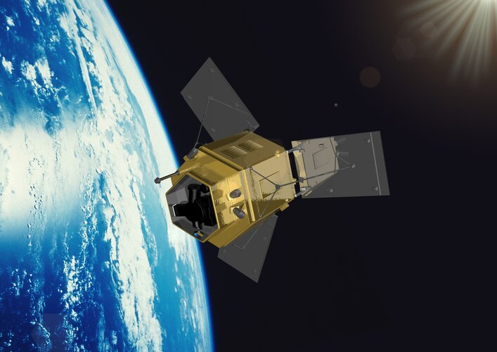
ESA has awarded a contract worth €160 million to Airbus in the UK to build the Earth Explorer FORUM satellite. This exciting new mission will yield unique insight into the planet’s radiation budget and how it is controlled – thereby filling in a critical missing piece of the climate jigsaw.
Short for Far-infrared Outgoing Radiation Understanding and Monitoring, FORUM is ESA’s ninth Earth Explorer mission.
Zveřejnění obsahu informací poskytnutých na žádost dle zákona č. 106/1999 Sb. za rok 2022
28.6.2022 8:47 ČÚZK /Urady/Katastralni-urady/Katastralni-urady/Katastralni-urad-pro-Zlinsky-kraj/Casto-hledane-informace/Poskytovani-informaci-106-1999-Sb/Zverejneni-obsahu-informaci-poskytnutych-na-za-(1)/Zverejneni-obsahu-informaci-poskytnutych-na-za-(5)Zveřejnění obsahu informací poskytnutých na žádost dle zákona č. 106/1999 Sb. za rok 2022
28.6.2022 8:47 ČÚZK - předpisy a opatření Katastrální úřad pro Zlínský krajzveřejňuje obsah informace poskytnutých na žádost dle zákona č. 106/1999 Sb. za rok
2022
Letní promo sleva 20 % na Autodesk Fusion 360 a 30 % na Fusion Extensions
28.6.2022 0:00 Arkance SystemsNeváhejte a využijte letní slevovou akci na Fusion 360 a na Fusion Extensions. Až do 22. července 2022.
Zpráva Letní promo sleva 20 % na Autodesk Fusion 360 a 30 % na Fusion Extensions pochází z arkance-systems.cz.
AgEagle Aerial Systems Announces Pricing of $10 Million Registered Direct Offering
27.6.2022 17:41 GISCafe.com Webcasts-Webinars WICHITA, Kan., June 27, 2022 (GLOBE NEWSWIRE) -- AgEagle Aerial Systems Inc. (NYSE American: UAVS) (“AgEagle” or the …CoreLogic Names Patrick Dodd CEO
27.6.2022 17:40 GISCafe.com Webcasts-Webinars IRVINE, Calif. — (BUSINESS WIRE) — June 27, 2022 —CoreLogic announced today that Patrick Dodd has been appointed president and …
Getting faster information with digital twin implementation
27.6.2022 17:33 Bentley SystemsPressCoverage
Oil Review Africa, Middle East
Read the articleIts not just investing in technology
27.6.2022 16:50 Bentley SystemsPressCoverage
Smart Water Magazine, Southern Europe
Read the articleMetaverse
27.6.2022 16:45 Bentley SystemsPressCoverage
Civil Engineering Surveyor, UK&I
Read the articleHERE helps automakers reach higher car safety ratings with advanced speed assistance
27.6.2022 16:43 GISCafe.com Webcasts-Webinars HERE helps car manufacturers comply with the latest updates to New Car Assessment Programs (NCAP) in Europe and Australia by combining speed limit …Verisk and Loveland Innovations Integration Expedites Property Claims Scoping Process
27.6.2022 16:43 GISCafe.com Webcasts-Webinars JERSEY CITY, N.J. and PLEASANT GROVE, Utah, June 27, 2022 (GLOBE NEWSWIRE) -- Insurance adjusters and contractors can now expedite the estimate …MissionGO Provides Michigan’s First Real-World Cargo Delivery Operations via UAS
27.6.2022 16:43 GISCafe.com Webcasts-Webinars DETROIT, June 27, 2022 (GLOBE NEWSWIRE) -- MissionGO Unmanned Systems, a global leader in uncrewed aircraft systems (UAS) production and …Epson Now Shipping New High-Speed, Compact SureColor T7770D 44-Inch Technical, CAD and Graphics Printer
27.6.2022 16:43 GISCafe.com Webcasts-Webinars LOS ALAMITOS, Calif., June 27, 2022 — (PRNewswire) — With a space-saving design to fit into office spaces and production …Exodigo Underground Imaging Platform Helps Utility Infrastructure Engineering and Construction Company Avoid 50 Percent More Utility Hits
27.6.2022 16:43 GISCafe.com Webcasts-Webinars TEL AVIV, Israel and PALO ALTO, Calif., June 27, 2022 — (PRNewswire) — Exodigo, a technology innovator combining the power of …Digital Twins and the Gemini Papers pt2
27.6.2022 16:38 Bentley SystemsPressCoverage
dc hub, UK&I
Read the articleCNC Tvar
27.6.2022 16:31 Arkance SystemsČeská společnost je jedním z nejvýznamnějších světových producentů turbín do hydroelektráren, využívá software Autodesk PowerMill
Zpráva CNC Tvar pochází z arkance-systems.cz.
Přerušení provozu DP a WSDP ve čtvrtek 30.6.2022
27.6.2022 14:54 GEUSware Upozorňujeme naše uživatele, že ČÚZK ve čtvrtek 30.6.2022 od 16:30 do cca 21:00 zcela přeruší provoz Dálkového přístupu (DP) i Webových služeb dálkového přístupu (WSDP). Z tohoto důvodu budou v GEUSu nefunkční Podklady měření a Odesílání GP.Bentley Systems Recognized among the 50 Most Community minded Businesses
27.6.2022 14:48 Bentley SystemsPress Announcements
Bentley Systems Recognized among the 50 Most Community minded Businesses
27.6.2022 14:48 Bentley SystemsPress Announcements
Přihlašování do ISÚI přes JIP vyřešené
27.6.2022 12:17 ČÚZK /ruian/Editacni-agendovy-system-ISUI/Provozni-informace-a-odstavky/Archiv-PROD/Prihlasovani-do-ISUI-pres-JIP-vyreseneVýběrové řízení vedoucí Oddělení digitalizace leteckého měřického snímkování
27.6.2022 11:23 ČÚZK - volná místa Zeměměřický úřad vypisuje výběrové řízení na místo Výběrové řízení vedoucí Oddělení digitalizace leteckého měřického snímkováníVýběrové řízení vedoucí Oddělení digitalizace leteckého měřického snímkování
27.6.2022 11:23 ČÚZK /Urady/Zememericky-urad/Uredni-deska/Oznameni-a-jina-uredni-sdeleni/Volna-mista/DMS/Vyberove-rizeni-vedouci-Oddeleni-digitalizace-leteVýběrové řízení vedoucí Oddělení digitalizace leteckého měřického snímkování
27.6.2022 11:23 ČÚZK - předpisy a opatření Zeměměřický úřadvypisuje výběrové řízení na místo
Výběrové řízení vedoucí Oddělení digitalizace leteckého měřického snímkování
Výběrové řízení vedoucí Oddělení digitalizace leteckého měřického snímkování
27.6.2022 11:23 Zeměměřický úřad Zeměměřický úřadvypisuje výběrové řízení na místo
Výběrové řízení vedoucí Oddělení digitalizace leteckého měřického snímkování
Odborný referent/vrchní referent – poskytování informací KN
27.6.2022 11:05 ČÚZK - volná místa Katastrální úřad pro Moravskoslezský kraj Katastrální pracoviště Opava vypisuje výběrové řízení na místo Odborný referent/vrchní referent – poskytování informací KNOdborný referent/vrchní referent – poskytování informací KN
27.6.2022 11:05 ČÚZK - předpisy a opatření Katastrální úřad pro Moravskoslezský kraj Katastrální pracoviště Opavavypisuje výběrové řízení na místo
Odborný referent/vrchní referent – poskytování informací KN
Rada/odborný rada – rozhodování o povolení vkladu
27.6.2022 11:01 ČÚZK - předpisy a opatření Katastrální úřad pro Moravskoslezský kraj Katastrální pracoviště Opavavypisuje výběrové řízení na místo
Rada/odborný rada – rozhodování o povolení vkladu
Rada/odborný rada – rozhodování o povolení vkladu
27.6.2022 11:01 ČÚZK /Urady/Katastralni-urady/Katastralni-urady/Katastralni-urad-pro-Moravskoslezsky-kraj/Uredni-deska/Oznameni-a-jina-uredni-sdeleni/Volna-mista/DMS/Rada-odborny-rada-–-rozhodovani-o-povoleni-vkl-(1)Rada/odborný rada – rozhodování o povolení vkladu
27.6.2022 11:01 ČÚZK - volná místa Katastrální úřad pro Moravskoslezský kraj Katastrální pracoviště Opava vypisuje výběrové řízení na místo Rada/odborný rada – rozhodování o povolení vkladuVrchní referent/rada – obnova katastrálního operátu
27.6.2022 10:58 ČÚZK /Urady/Katastralni-urady/Katastralni-urady/Katastralni-urad-pro-Moravskoslezsky-kraj/Uredni-deska/Oznameni-a-jina-uredni-sdeleni/Volna-mista/DMS/Vrchni-referent-rada-–-obnova-katastralniho-op-(2)Vrchní referent/rada – obnova katastrálního operátu
27.6.2022 10:58 ČÚZK - volná místa Katastrální úřad pro Moravskoslezský kraj technický odbor vypisuje výběrové řízení na místo Vrchní referent/rada – obnova katastrálního operátuVrchní referent/rada – obnova katastrálního operátu
27.6.2022 10:58 ČÚZK - předpisy a opatření Katastrální úřad pro Moravskoslezský kraj technický odborvypisuje výběrové řízení na místo
Vrchní referent/rada – obnova katastrálního operátu
Odborný referent/vrchní referent – obnova katastrálního operátu
27.6.2022 10:53 ČÚZK - volná místa Katastrální úřad pro Moravskoslezský kraj technický odbor vypisuje výběrové řízení na místo Odborný referent/vrchní referent – obnova katastrálního operátuOdborný referent/vrchní referent – obnova katastrálního operátu
27.6.2022 10:53 ČÚZK - předpisy a opatření Katastrální úřad pro Moravskoslezský kraj technický odborvypisuje výběrové řízení na místo
Odborný referent/vrchní referent – obnova katastrálního operátu
EUSPA takes on the Space Surveillance and Tracking helpdesk as of 2023
27.6.2022 10:53 European GNSS Agency Front Desk service.")
The EU Agency for the Space Programme (EUSPA) will take responsibility for the Programme’s Space Surveillance and Tracking (SST) Front Desk operations service, following a Commission’s Decision of 03 June 2022.
The responsibility will be transferred from the European Satellite Centre (SatCen), who currently operates the service, to EUSPA’s Galileo Security Monitoring Centre (GSMC) in Madrid, which will now serve as the SST Front Desk. The Front Desk is the main interface for the delivery of SST information and services, including activities related to user coordination, service performance, engagement and promotion.
The EU established the SST as a means of mitigating the increasing risk of collision between European operators’ space assets, such as Galileo satellites, and other spacecraft and debris. To do this, the system uses a network of nationally owned ground-based sensors and other infrastructure to survey and track artificial space objects orbiting Earth.
The SST is part of the Space Situational Awareness (SSA) component of the EU Space Programme and plays a key role in ensuring the safety and security of the European economies, societies and citizens who rely on space-based applications. As such, transferring the system’s Front Desk to EUSPA aligns with the Agency’s mission of linking space to user needs and further strengthens the resiliency of the EU Space Programme.
In preparation for the transfer, EUSPA is working closely with SatCen to design, procure, validate and implement the necessary IT infrastructure. The two organisations are also cooperating on the handover of the relevant operational information and related competencies. EUSPA is currently in the process of onboarding the necessary talent to manage the service.
In addition to its SST Front Desk responsibilities, EUSPA is preparing the system’s security monitoring jointly with the European Commission and the EUSST Consortium, particularly as to establishing the security requirements needed to shape the SST network. The Agency will also operate the security monitoring of the network.
Media note: This feature can be republished without charge provided the European Union Agency for the Space Programme (EUSPA) is acknowledged as the source at the top or the bottom of the story. You must request permission before you use any of the photographs on the site. If you republish, we would be grateful if you could link back to the EUSPA website (http://www.euspa.europa.eu).
Nedostupné produkční prostředí ISÚI
27.6.2022 10:15 ČÚZK /ruian/Editacni-agendovy-system-ISUI/Provozni-informace-a-odstavky/Archiv-PROD/Nedostupne-produkcni-prostredi-ISUI-(33)Kraj Vysočina zná vítěze soutěže o nejlepší středoškolskou StoryMapu
27.6.2022 9:55 ARCDATAKraj Vysočina opět uspořádal středoškolskou soutěž o nejlepší mapu s příběhem. Tentokrát bylo zvoleno téma „Jak vidím a chci zlepšit místo, kde žiju“ a stejně jako v minulém ročníku byly všechny výstupy prezentovány pomocí aplikace ArcGIS StoryMaps.
Na nejvyšších příčkách jednoznačně dominovali studentky a studenti ze Střední uměleckoprůmyslové školy Jihlava-Helenín. Letošní vítězkou se stala Natálie Egartová, jejíž story mapa popisuje problematická místa ve městě Ledeč nad Sázavou a zároveň navrhuje, jak na ně upozornit. Druhou příčku obsadila Monika Pačanová, která ve své story mapě prezentovala problematiku zastávek hromadné dopravy na Vysočině. A na bronzové pozici se umístil Alois Sklenář, který se zaměřil na rozmístění veřejných pítek v Jihlavě.
Posíláme gratulace oceněným a děkujeme všem, kteří se zúčastnili. Prezentace nápadů a dat skrze mapy nás vždy těší a jsme rádi, že se na této studentské soutěži můžeme podílet.
Po River dries up
27.6.2022 9:30 ESA Observing the Earth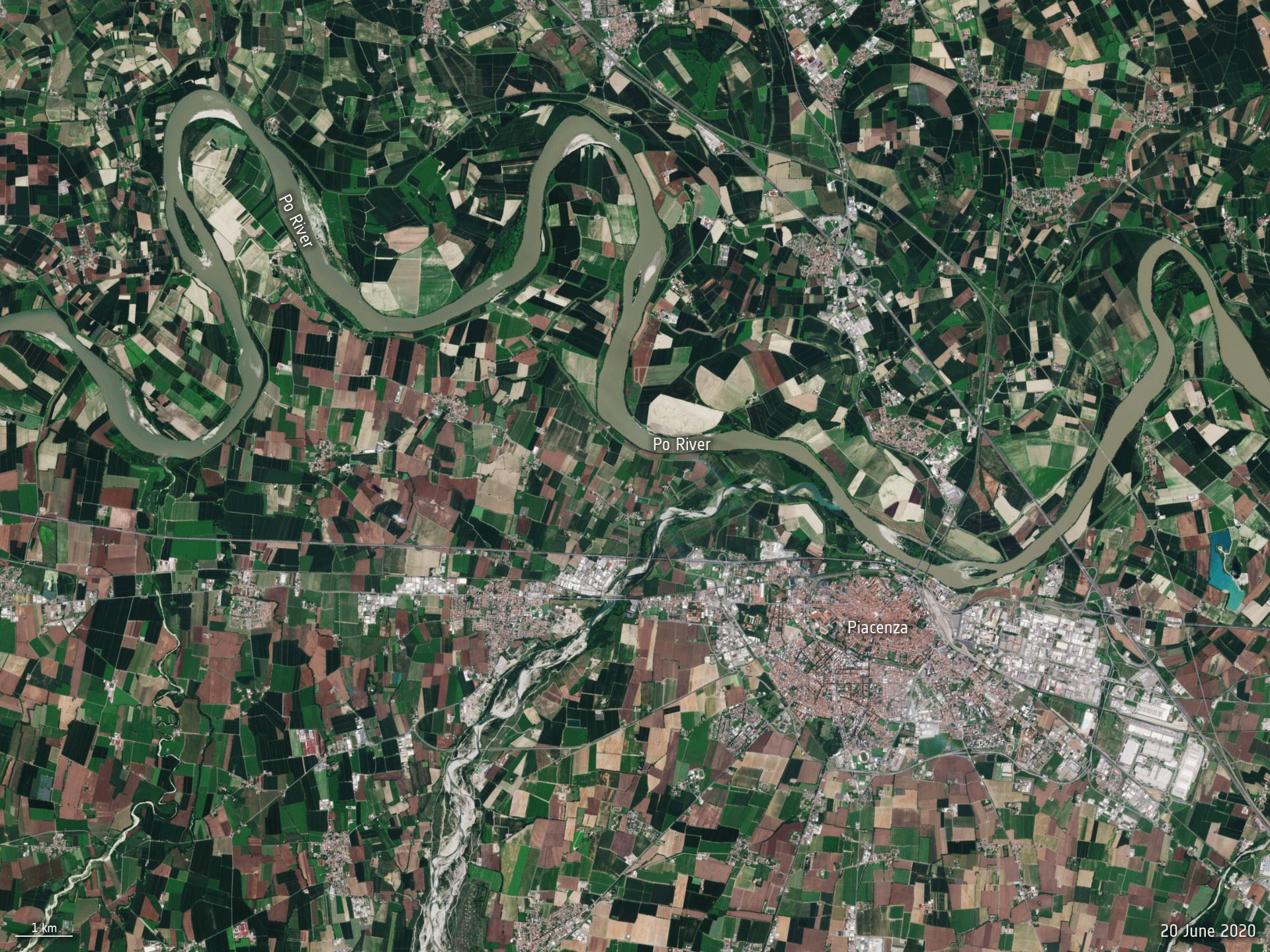 Image:
The Po River, the longest river in Italy, is hitting record low water levels after months without heavy rainfall. This Copernicus Sentinel-2 animation reveals how the river has significantly shrunk between June 2020 and June 2022.
Image:
The Po River, the longest river in Italy, is hitting record low water levels after months without heavy rainfall. This Copernicus Sentinel-2 animation reveals how the river has significantly shrunk between June 2020 and June 2022.
Interview with Zacc Dukowitz, Senior Communications Manager, Flyability
27.6.2022 9:00 GISCafe.com Webcasts-WebinarsNová verze DAEX DESIGN Standard 23
25.6.2022 12:37 ŠPINAR - softwareVážení zákazníci,
nová verze DAEX DESIGN Professional 23 CZ již na trhu České a Slovenské republiky.
The post Nová verze DAEX DESIGN Standard 23 appeared first on ŠPINAR – software.
Nová verze DAEX DESIGN Standard 23
25.6.2022 12:37 ŠPINAR - softwareVážení zákazníci,
nová verze DAEX DESIGN Standard 23 CZ již na trhu České a Slovenské republiky.
The post Nová verze DAEX DESIGN Standard 23 appeared first on ŠPINAR – software.
Nová verze DAEX DESIGN Standard 23
25.6.2022 12:37 ŠPINAR - software Vážení zákazníci,nová verze DAEX DESIGN Standard 23 CZ již na trhu České a Slovenské republiky.
Nová verze DAEX DESIGN Standard 23
25.6.2022 12:37 ŠPINAR - softwareVážení zákazníci,
nová verze DAEX DESIGN Standard 23 CZ již na trhu České a Slovenské republiky.
The post Nová verze DAEX DESIGN Standard 23 appeared first on ŠPINAR – software.
Kombinace mobilního skenování GeoSLAM s daty z leteckého snímkování
25.6.2022 9:36 3gon Vše zpracované ve 3DSurvey!Za hranice dneška – Steven Cost, šéf divize Safety, Infrastructure & Geospatial na konferenci HxGN LIVE Global 2022
24.6.2022 21:07 GeoBusinessZahajovací přednáška Stevena Costa, ředitele divize Safety, Infrastructure & Geospatial ve firmě Hexagon, na celosvětové konferenci HxGN Live Global 2022.
The post Za hranice dneška – Steven Cost, šéf divize Safety, Infrastructure & Geospatial na konferenci HxGN LIVE Global 2022 appeared first on GeoBusiness.
Satellite Vu Selects Orbit Logic Planning Software for Thermal Imaging Constellation
24.6.2022 20:07 GISCafe.com Webcasts-Webinars GREENBELT, MD (June 20, 2022) – Orbit Logic announced today that UK satellite firm Satellite Vu has selected Orbit Logic’s collection …Dronedge 2022 – 7. konference Aliance
24.6.2022 12:19 UAVAPřijměte pozvání na již sedmý ročník největší akce v ČR, konference Aliance pro bezpilotní letecký průmysl – Dronedge, která kromě výrobců, provozovatelů dronů sdružuje rovněž univerzity, výzkumné ústavy a další instituce či firmy. Program nabídne tři tématické bloky. První seznámí s aktuálním stavem české a slovenské legislativy a implementací evropské legislativy spojené s drony, U-space a stavem novely zákona o civlním […]
The post Dronedge 2022 – 7. konference Aliance appeared first on UAV Aliance pro bezpilotní letecký průmysl.
Dronedge 2022 – 7. konference Aliance
24.6.2022 12:19 UAVAPřijměte pozvání na již sedmý ročník největší akce svého druhu zaměřené na drony ve Střední Evropě, konference Aliance pro bezpilotní letecký průmysl – Dronedge, která kromě výrobců, provozovatelů dronů sdružuje rovněž univerzity, výzkumné ústavy a další instituce či firmy. Program nabídne tři tématické bloky. První seznámí s aktuálním stavem české a slovenské legislativy a implementací evropské legislativy spojené s drony, U-space […]
The post Dronedge 2022 – 7. konference Aliance appeared first on UAV Aliance pro bezpilotní letecký průmysl.
Odborný referent / vrchní referent – návrh zápisu v katastru v oddělení aktualizace KN Katastrálního
24.6.2022 10:51 ČÚZK - volná místa Katastrální úřad pro Zlínský kraj Katastrální pracoviště Zlín vypisuje výběrové řízení na místo Odborný referent / vrchní referent – návrh zápisu v katastru v oddělení aktualizace KN KatastrálníhoOdborný referent / vrchní referent – návrh zápisu v katastru v oddělení aktualizace KN Katastrálního
24.6.2022 10:51 ČÚZK - předpisy a opatření Katastrální úřad pro Zlínský kraj Katastrální pracoviště Zlínvypisuje výběrové řízení na místo
Odborný referent / vrchní referent – návrh zápisu v katastru v oddělení aktualizace KN Katastrálního pracoviště Zlín
Verze 1.3 popisu služeb
24.6.2022 10:49 ČÚZK - předpisy a opatření V záložce Popis rozhraní byla zveřejněna aktualizovaná verze 1.3 dokumentu Popis a technické parametry služeb IS DMVSOdborný referent – poskytování informací KN, poskytování podkladů, nahlížení do KN, poskytování info
24.6.2022 10:41 ČÚZK - volná místa Katastrální úřad pro Zlínský kraj Katastrální pracoviště Zlín vypisuje výběrové řízení na místo Odborný referent – poskytování informací KN, poskytování podkladů, nahlížení do KN, poskytování infoOdborný referent – poskytování informací KN, poskytování podkladů, nahlížení do KN, poskytování info
24.6.2022 10:41 ČÚZK - předpisy a opatření Katastrální úřad pro Zlínský kraj Katastrální pracoviště Zlínvypisuje výběrové řízení na místo
Odborný referent – poskytování informací KN, poskytování podkladů, nahlížení do KN, poskytování informací PK v oddělení dokumentace KN Katastrálního pracoviště Zlín
EUSPA re-opens testing campaign for INAV improvements implementation
24.6.2022 10:35 European GNSS Agency Open Service Signal-In-Space Interface Control Document (OS SIS ICD) Issue 2.0 contains the publicly available information on the Galileo Signal-In-Space.")
(The information has been updated as of 29 July 2022)
The European Union Agency for the Space Programme (EUSPA) is re-opening a testing campaign for INAV improvements implementation and hereby invites external stakeholders to express their interest in participating in such testing campaign.
The testing will cover any of the three I/NAV improvements (SSP, FEC-2, RedCED), that will be tested in laboratory using simulated realistic scenarios, including open sky as well as impaired environments. The tests will allow the participants to have confirmation of the correct implementation of the OSSISICD 2.0. In case of specific interest, legacy receivers (e.g. not implementing I/NAV improvements) could be also tested, solely at the scope of confirming that they are not impacted anyhow by the introduction of the new I/NAV capabilities (backward compatibility is in any case guaranteed “by design” for any receiver that is fully compliant with the Galileo OS SIS ICD provisions, and referring in particular to section 4.1.2).
The characteristics of the testing campaign are described here.
The interested participants may be invited to provide their product(s) before 1 October to the premises indicated below according to the terms and conditions that will be communicated by the agency and be ready to provide any remote technical assistance needed during the testing as well as all the necessary interface documentation required for the testing. Any further detailed provision, including the possibility to provide the testing laboratories with ad-hoc receiver development platforms facilitating the testing activities, will be discussed with the interested participants.
The tests will be executed at the laboratories of the European Commission’s Joint Research Centre in Ispra, Italy, and of the European Space Agency ESA/ESTEC in Noordwijk, The Netherlands. Each applicant will be assigned by EUSPA to any of the two laboratories depending on the specific conditions and availability.
Testing is currently foreseen to start on 1 October 2022. The EUSPA reserves the right to change the scope, and timeline of the procedure.
Express your interest
If you are interested in participating in the testing campaign above, please express your interest by sending an email before 15/09/2022, 17:00 (Prague local time) to the following email address: market@euspa.europa.eu. The subject of the email shall be “INAV improvements implementation testing campaign: 2nd call”.
Media note: This feature can be republished without charge provided the European Union Agency for the Space Programme (EUSPA) is acknowledged as the source at the top or the bottom of the story. You must request permission before you use any of the photographs on the site. If you republish, we would be grateful if you could link back to the EUSPA website (http://www.euspa.europa.eu).
EUSPA re-opens testing campaign for INAV improvements implementation
24.6.2022 10:35 European GNSS AgencyThe European Union Agency for the Space Programme (EUSPA) is re-opening a testing campaign for INAV improvements implementation and hereby invites external stakeholders to express their interest in participating in such testing campaign.
The testing will cover any of the three I/NAV improvements (SSP, FEC-2, RedCED), that will be tested in laboratory using simulated realistic scenarios, including open sky as well as impaired environments. The tests will allow the participants to have confirmation of the correct implementation of the OSSISICD 2.0. In case of specific interest, legacy receivers (e.g. not implementing I/NAV improvements) could be also tested, solely at the scope of confirming that they are not impacted anyhow by the introduction of the new I/NAV capabilities (backward compatibility is in any case guaranteed “by design” for any receiver that is fully compliant with the Galileo OS SIS ICD provisions, and referring in particular to section 4.1.2).
The characteristics of the testing campaign are described here.
The interested participants may be invited to provide their product(s) before 1 August or 1 October to the premises indicated below according to the terms and conditions that will be communicated by the agency and be ready to provide any remote technical assistance needed during the testing as well as all the necessary interface documentation required for the testing. Any further detailed provision, including the possibility to provide the testing laboratories with ad-hoc receiver development platforms facilitating the testing activities, will be discussed with the interested participants.
The tests will be executed at the laboratories of the European Commission’s Joint Research Centre in Ispra, Italy, and of the European Space Agency ESA/ESTEC in Noordwijk, The Netherlands. Each applicant will be assigned by EUSPA to any of the two laboratories depending on the specific conditions and availability.
Testing is currently foreseen to be done in three batches, starting on 1 August and 1 October 2022. The EUSPA reserves the right to change the scope, and timeline of the procedure.
Express your interest
If you are interested in participating in the testing campaign above, please express your interest by sending an email before 15/07/2022, 17:00 (Prague local time) to the following email address: market@euspa.europa.eu. The subject of the email shall be “INAV improvements implementation testing campaign: 2nd call”.
Media note: This feature can be republished without charge provided the European Union Agency for the Space Programme (EUSPA) is acknowledged as the source at the top or the bottom of the story. You must request permission before you use any of the photographs on the site. If you republish, we would be grateful if you could link back to the EUSPA website (http://www.euspa.europa.eu).
Earth from Space: Lake Balkhash
24.6.2022 10:00 ESA Observing the Earth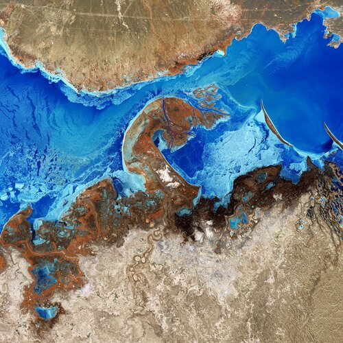
Lake Balkhash, the largest lake in Central Asia, is featured in this false-colour image captured by the Copernicus Sentinel-2 mission.
Earth from Space: Lake Balkhash
24.6.2022 10:00 ESA Observing the Earth
Lake Balkhash, the largest lake in Central Asia, is featured in this false-colour image captured by the Copernicus Sentinel-2 mission.
Přerušení provozu DP a WSDP ve čtvrtek 30.6.2022 od 16:30 do cca 21:00.
24.6.2022 9:56 Dálkový přístup k údajům KN ČR Vážení uživatelé,oznamujeme, že ve čtvrtek 30.6.2022 od 16:30 bude z provozních důvodů zcela přerušen provoz Dálkového přístupu i Webových služeb dálkového přístupu. Obnovení provozu předpokládáme v cca 21 hodin. U této verze nedochází ke změnám webových služeb.
Za komplikace tímto způsobené se omlouváme a děkujeme za pochopení.