


![]()

zprávy
zdroje zpráv:
Ako od mája elektronicky komunikovať s katastrom
6.6.2022 11:30
ÚGKK SR
Denník N publikoval na svojich stránkach článok Ako od mája elektronicky komunikovať s katastrom (otázky a odpovede)
Ako od mája elektronicky komunikovať s katastrom
6.6.2022 11:30 ÚGKK SRDenník N publikoval na svojich stránkach článok Ako od mája elektronicky komunikovať s katastrom (otázky a odpovede)
Oznámení o vyhlášení výběrového řízení na služební místo rada/odborný rada – vedoucí oddělení aktua
6.6.2022 10:59 ČÚZK - předpisy a opatření Český úřad zeměměřický a katastrální zveřejnil novou aktualitu: Oznámení o vyhlášení výběrového řízení na služební místo rada/odborný rada – vedoucí oddělení aktualizace KN - VOA10, KÚ pro Plzeňský kraj, KP Plzeň - městoOznámení o vyhlášení výběrového řízení na služební místo rada/odborný rada – vedoucí oddělení aktua
6.6.2022 10:59 ČÚZK /Urady/Katastralni-urady/Katastralni-urady/Katastralni-urad-pro-Plzensky-kraj/O-uradu/Aktuality/Oznameni-o-vyhlaseni-vyberoveho-rizeni-na-sluzebniOznámení o vyhlášení výběrového řízení na služební místo rada/odborný rada – vedoucí oddělení aktual
6.6.2022 10:54 ČÚZK - volná místa Katastrální úřad pro Plzeňský kraj Katastrální pracoviště Plzeň-město vypisuje výběrové řízení na místo Oznámení o vyhlášení výběrového řízení na služební místo rada/odborný rada – vedoucí oddělení aktualOznámení o vyhlášení výběrového řízení na služební místo rada/odborný rada – vedoucí oddělení aktual
6.6.2022 10:54 ČÚZK - předpisy a opatření Katastrální úřad pro Plzeňský kraj Katastrální pracoviště Plzeň-městovypisuje výběrové řízení na místo
Oznámení o vyhlášení výběrového řízení na služební místo rada/odborný rada – vedoucí oddělení aktualizace KN - VOA10, KÚ pro Plzeňský kraj, KP Plzeň - město
Oznámení o vyhlášení výběrového řízení na služební místo rada/odborný rada – vedoucí oddělení aktual
6.6.2022 10:54 ČÚZK /Urady/Katastralni-urady/Katastralni-urady/Katastralni-urad-pro-Plzensky-kraj/Uredni-deska/Oznameni-a-jina-uredni-sdeleni/Volna-mista/DMS/Oznameni-o-vyhlaseni-vyberoveho-rizeni-na-sluzebniRealizace Digitální technické mapy ČR se rozbíhá a T-MAPY jsou u toho
6.6.2022 10:33 T-MAPYThe post Realizace Digitální technické mapy ČR se rozbíhá a T-MAPY jsou u toho appeared first on T-MAPY spol. s r.o..
Realizace Digitální technické mapy ČR se rozbíhá a T-MAPY jsou u toho
6.6.2022 10:33 T-MAPYThe post Realizace Digitální technické mapy ČR se rozbíhá a T-MAPY jsou u toho appeared first on T-MAPY spol. s r.o..
výběrové řízení na KP Jihlava
6.6.2022 9:44 ČÚZK - předpisy a opatření Katastrální úřad pro Vysočinu - Katastrální pracoviště Jihlava zveřejnil novou aktualitu: OZNÁMENÍ O VYHLÁŠENÍ VÝBĚROVÉHO ŘÍZENÍ na služební místo odborný referent/vrchní referent v oddělení dokumentace KN Katastrálního pracoviště Jihlava.odborný-vrchní referent - dokumentace KP Jihlava
6.6.2022 9:28 ČÚZK - volná místa Katastrální úřad pro Vysočinu Katastrální pracoviště Jihlava vypisuje výběrové řízení na místo odborný-vrchní referent - dokumentace KP Jihlavaodborný-vrchní referent - dokumentace KP Jihlava
6.6.2022 9:28 ČÚZK - předpisy a opatření Katastrální úřad pro Vysočinu Katastrální pracoviště Jihlavavypisuje výběrové řízení na místo
odborný-vrchní referent - dokumentace KP Jihlava
odborný-vrchní referent - dokumentace KP Jihlava
6.6.2022 9:28 ČÚZK /Urady/Katastralni-urady/Katastralni-urady/Katastralni-urad-pro-Vysocinu/Uredni-deska/Oznameni-a-jina-uredni-sdeleni/Volna-mista/DMS/odborny-vrchni-referent-dokumentace-KP-JihlavaSTUDENTSKÁ SOUTĚŽ 2021 / 2022
5.6.2022 18:18 ŠPINAR - softwareVážení zákazníci,
dovolujeme si Vás informovat o nové verzi DAEX DESIGN 23 CZ. Již brzy na trhu v ČR a SR-
The post STUDENTSKÁ SOUTĚŽ 2021 / 2022 appeared first on ŠPINAR – software.
STUDENTSKÉ PROJEKTY 2021 / 2022
5.6.2022 18:18 ŠPINAR - softwareVážení přátelé,
dovolujeme si Vás informovat o výsledcích veřejné soutěže - Studentské projekty 2021 / 2022
The post STUDENTSKÉ PROJEKTY 2021 / 2022 appeared first on ŠPINAR – software.
STUDENTSKÁ SOUTĚŽ 2021 / 2022
5.6.2022 18:18 ŠPINAR - softwareVážení přátelé,
dovolujeme si Vás informovat o výsledcích soutěže studentské projekty 2021 / 2022
The post STUDENTSKÁ SOUTĚŽ 2021 / 2022 appeared first on ŠPINAR – software.
STUDENTSKÉ PROJEKTY 2021 / 2022
5.6.2022 18:18 ŠPINAR - software Vážení přátelé,dovolujeme si Vás informovat o výsledcích veřejné soutěže - Studentské projekty 2021 / 2022
rada/odborný rada – kontrolor
3.6.2022 20:16 ČÚZK - předpisy a opatření Katastrální úřad pro hlavní město Prahu Katastrální pracoviště Prahavypisuje výběrové řízení na místo
rada/odborný rada – kontrolor
rada/odborný rada – kontrolor
3.6.2022 20:16 ČÚZK /Urady/Katastralni-urady/Katastralni-urady/Katastralni-urad-pro-hlavni-mesto-Prahu/Volna-mista/DMS/rada-odborny-rada-–-kontrolorrada/odborný rada – kontrolor
3.6.2022 20:16 ČÚZK - volná místa Katastrální úřad pro hlavní město Prahu Katastrální pracoviště Praha vypisuje výběrové řízení na místo rada/odborný rada – kontrolorNextech AR To Spin Out Real-World Augmented Reality Spatial Mapping Platform ARitize Maps
3.6.2022 19:10 GISCafe.com Webcasts-Webinars Nextech and PC 1 Corp. Enter into Binding Agreement to Complete Qualifying Transaction on the TSX-VSpin Out Asset ARitize Maps is bringing the …
Reliability Radio EP 276 Greg Demchak Bentley Systems
3.6.2022 17:07 Bentley SystemsPressCoverage
ReliabilityWeb, USA
Read the articleIIJA Act Triggers Flood of Infrastructure Work
3.6.2022 17:00 Bentley SystemsPressCoverage
Cadalyst, USA
Read the articleVelodyne Lidar Wins GeoBuiz Summit Award for Innovation in Mapping Technology
3.6.2022 16:15 GISCafe.com Webcasts-Webinars Velodyne’s Intelligent Infrastructure Solution Creates 3D Maps of Roads and Intersections to Advance Safety in Communities GloballySAN JOSE, …
Omezení provozu kontaktního místa v Bystřici nad Pernštejnem
3.6.2022 15:10 ČÚZK - předpisy a opatření Katastrální úřad pro Vysočinu - Katastrální pracoviště Žďár nad Sázavou zveřejnil novou aktualitu: Katastrální úřad pro Vysočinu, Katastrální pracoviště Žďár nad Sázavou oznamuje, že dne 4.7.2022 bude Kontaktní místo Bystřice nad Pernštejnem z provozních důvodů uzavřeno.V případě potřeby se obracejte na podatelnu Katastrálního pracoviště Žďár nad Sázavou, se sídlem Strojírenská 8, 591 27 Žďár nad Sázavou.
EGNOS makes flying sustainably ‘easy’
3.6.2022 14:32 European GNSS Agency
EGNOS, the European Geostationary Navigation Overlay Service, has revolutionised the way we fly: creating greater access to small and regional airports, increasing safety and facilitating more sustainable flight routes across Europe.
“From the commercial, regional, general and business aviation sectors to original equipment manufacturers (OEMs), airports and the end user – everyone benefits from EGNOS,” says Jean-Marc Piéplu, Head of EGNOS Services Department at the EU Agency for the Space Programme (EUSPA).
With news that Airbus has delivered the first EGNOS-enabled A320neo to the popular low-cost airline EasyJet, soon even more passengers will be flying with EGNOS. The A320neo is the world’s most popular aircraft family for short-haul flights, claiming the greatest number of aircraft sold and delivered.
Accurate guidance for safer landings
As an alternative to ground-based Instrument Landing System (ILS) navigational aids, EGNOS-enabled approaches, often referred to as localiser performance with vertical guidance (LPV), utilise geostationary satellites and a network of ground stations to receive, analyse and augment GNSS signals. In doing so, it enables aircraft approaches that are operationally equivalent to ILS CAT I, providing lateral and vertical guidance without the need for visual contact with the ground until a decision height of only 200 feet above the runway as minimum.
In addition to providing pilots with accurate guidance for safer landings (even in poor weather conditions), EGNOS is also more cost effective to install, maintain and operate than equivalent ground-based systems. This makes EGNOS particularly attractive to Europe’s many small and regional airports that simply cannot afford the high cost of ILS.
“Having the ability to cost-effectively offer accurate vertical guidance makes these airports safer and more attractive to short-haul flights,” explains Piéplu “Moreover, EGNOS based procedures are mandatory in all instrument runways by 2024, and will be the main means for CAT-I by 2030 in EU.”
Towards a more sustainable aviation sector
Not only are these EGNOS-enabled approaches safer, they’re also more sustainable. “Having LPV in all airports give more choices for alternate airports, which means that the distance to be flown could be shorter, and results in less fuel being burned and more emissions being released,” adds Carmen Aguilera, Operational Market Development Officer at EUSPA. “EGNOS approaches, as enabler of PBN, allows shorter trajectories with respect to conventional approaches, which is more fuel efficient.”
Thanks to its lower decision height, EGNOS can help pilots better evaluate visibility conditions, which in many cases means avoiding the need to circle or divert – two manoeuvres that burn a lot of fuel. “Minimising diversions and aborted landings mean less fuel consumption, a win-win for both the environment and the airlines,” concludes Aguilera.
EGNOS services are delivered by the EGNOS service provider (ESSP) under a contract with EUSPA.
Media note: This feature can be republished without charge provided the European Union Agency for the Space Programme (EUSPA) is acknowledged as the source at the top or the bottom of the story. You must request permission before you use any of the photographs on the site. If you republish, we would be grateful if you could link back to the EUSPA website (http://www.euspa.europa.eu).
EGNOS makes flying sustainably ‘easy’
3.6.2022 14:32 European GNSS AgencyEGNOS, the European Geostationary Navigation Overlay Service, has revolutionised the way we fly: creating greater access to small and regional airports, increasing safety and facilitating more sustainable flight routes across Europe.
“From the commercial, regional, general and business aviation sectors to original equipment manufacturers (OEMs), airports and the end user – everyone benefits from EGNOS,” says Jean-Marc Piéplu, Head of EGNOS Services Department at the EU Agency for the Space Programme (EUSPA).
With news that Airbus has delivered the first EGNOS-enabled A320neo to the popular low-cost airline EasyJet, soon even more passengers will be flying with EGNOS. The A320neo is the world’s most popular aircraft family for short-haul flights, claiming the greatest number of aircraft sold and delivered.
Accurate guidance for safer landings
As an alternative to ground-based Instrument Landing System (ILS) navigational aids, EGNOS-enabled approaches, often referred to as localiser performance with vertical guidance (LPV), utilise geostationary satellites and a network of ground stations to receive, analyse and augment GNSS signals. In doing so, it enables aircraft approaches that are operationally equivalent to ILS CAT I, providing lateral and vertical guidance without the need for visual contact with the ground until a decision height of only 200 feet above the runway as minimum.
In addition to providing pilots with accurate guidance for safer landings (even in poor weather conditions), EGNOS is also more cost effective to install, maintain and operate than equivalent ground-based systems. This makes EGNOS particularly attractive to Europe’s many small and regional airports that simply cannot afford the high cost of ILS.
“Having the ability to cost-effectively offer accurate vertical guidance makes these airports safer and more attractive to short-haul flights,” explains Piéplu “Moreover, EGNOS based procedures are mandatory in all instrument runways by 2024, and will be the main means for CAT-I by 2030 in EU.”
Towards a more sustainable aviation sector
Not only are these EGNOS-enabled approaches safer, they’re also more sustainable. “Having LPV in all airports give more choices for alternate airports, which means that the distance to be flown could be shorter, and results in less fuel being burned and more emissions being released,” adds Carmen Aguilera, Operational Market Development Officer at EUSPA. “EGNOS approaches, as enabler of PBN, allows shorter trajectories with respect to conventional approaches, which is more fuel efficient.”
Thanks to its lower decision height, EGNOS can help pilots better evaluate visibility conditions, which in many cases means avoiding the need to circle or divert – two manoeuvres that burn a lot of fuel. “Minimising diversions and aborted landings mean less fuel consumption, a win-win for both the environment and the airlines,” concludes Aguilera.
EGNOS services are delivered by the EGNOS service provider (ESSP) under a contract with EUSPA.
Media note: This feature can be republished without charge provided the European Union Agency for the Space Programme (EUSPA) is acknowledged as the source at the top or the bottom of the story. You must request permission before you use any of the photographs on the site. If you republish, we would be grateful if you could link back to the EUSPA website (http://www.euspa.europa.eu).
Earth from Space: Puglia, Italy
3.6.2022 10:00 ESA Observing the Earth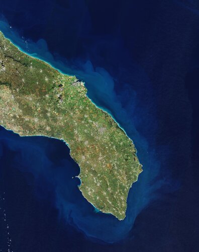
Part of Puglia, or Apulia, a region in southern Italy, is featured in this image captured by the Copernicus Sentinel-2 mission.
Mapová aplikace ÚPD - nové dokumentace
3.6.2022 9:53 Jihočeský krajV mapové aplikaci Územně plánovací dokumentace obcí byla aktualizována ÚPD obcí ORP Dačice – Hříšice, ORP Vimperk – Borová Lada, ORP Prachatice – Kratušín, Malovice, ORP České Budějovice – Vrábče, Hluboká nad Vltavou, Vitín, Římov, Dubné a Jankov.
20220603_Vrchní referent / rada oddělení dokumentace KN
3.6.2022 9:53 ČÚZK - předpisy a opatření Katastrální úřad pro Středočeský kraj - Katastrální pracoviště Praha-západ Vyhlášení výběrového řízení: Vrchní referent / rada oddělení dokumentace KN V části "Úřední deska", v sekci "Oznámení a jiná úřední sdělení" bylo vystaveno "Oznámení o vyhlášení výběrového řízení na obsazení služebního místa Vrchní referent / rada oddělení dokumentace KN"20220603_Vrchní referent / rada oddělení dokumentace KN
3.6.2022 9:53 ČÚZK /Urady/Katastralni-urady/Katastralni-urady/Katastralni-urad-pro-Stredocesky-kraj/Katastralni-pracoviste/KP-Praha-zapad/O-uradu/Aktuality/20210922_Odborny-referent-oddeleni-aktualizace-(8)Vrchní referent / rada oddělení dokumentace KN
3.6.2022 9:50 ČÚZK /Urady/Katastralni-urady/Katastralni-urady/Katastralni-urad-pro-Stredocesky-kraj/Uredni-deska/Oznameni-a-jina-uredni-sdeleni/Volna-mista/DMS/Vrchni-referent-rada-oddeleni-dokumentace-KNVrchní referent / rada oddělení dokumentace KN
3.6.2022 9:50 ČÚZK - předpisy a opatření Katastrální úrad pro Středočeský kraj Katastrální pracoviště Praha-západvypisuje výběrové řízení na místo
Vrchní referent / rada oddělení dokumentace KN
Vrchní referent / rada oddělení dokumentace KN
3.6.2022 9:50 ČÚZK - volná místa Katastrální úrad pro Středočeský kraj Katastrální pracoviště Praha-západ vypisuje výběrové řízení na místo Vrchní referent / rada oddělení dokumentace KNUnicorn na konferenci BIM ve stavebnictví 2022
3.6.2022 9:02 Unicorn Na co se má české stavebnictví připravit? Jaké jsou výhody a možnosti zavedení metody BIM? To jsou témata, která se aktivně probírají na letošní konferenci BIM ve stavebnictví. Unicorn jako dodavatel společného datového prostředí pro správu stavebních projektů na této konferenci nesmí chybět!Datamark Announces Awards For Innovative Women In Public Safety And Gis Industries
3.6.2022 9:00 GISCafe.com Webcasts-Webinars WHO: DATAMARK, the public safety geographic information systems (GIS) team of Michael Baker International. As trusted advisors in public …Kleos executes agreement with US Navy for maritime domain awareness exercise
3.6.2022 9:00 GISCafe.com Webcasts-Webinars Kleos Space Inc. (US subsidiary of Kleos Space S.A), a space-powered Radio Frequency Reconnaissance Data-as-a-Service (DaaS) and Mission-as-a-Service …Setkání eye-trakcking výzkumníků na UP
3.6.2022 8:04 Katedra geoinformatiky UP OlomoucNa katedře proběhlo historický první setkání výzkumníků z Univerzity Palackého využívajících při své práci eye-traking. V případě zájmu o další informace nebo možnosti zapojení se do společného výzkumu kontaktujte stanislav.popelka@upol.cz Víc o setkání poslal Žurnál UP https://www.zurnal.upol.cz/nc/zprava/clanek/vyzkumnici-debatovali-o-vyuziti-dat-ze-sledovani-pohybu-oci/
The post Setkání eye-trakcking výzkumníků na UP appeared first on Katedra geoinformatiky.
Esri Integrates LightBox Data to Expand Geocoding for Canadian Content
3.6.2022 2:32 GISCafe.com Webcasts-Webinars ArcGIS Users Can Now Access Newer and More Precise Address InformationREDLANDS, Calif. — (BUSINESS WIRE) — June 2, 2022 —
To …
] Flagship geospatial and location intelligence trade show Geo Connect Asia 2022 kicks off in Singapore
2.6.2022 22:49 GISCafe.com Webcasts-Webinars The two-day exhibition and conference aim to reconnect the industry and build momentum for the continued development of geospatial capabilities …Implement Digital Twin Faster with A Trustworthy Asset Information System
2.6.2022 21:49 Bentley SystemsPressCoverage
Daily CADCAM, India
Read the articleFaster Infra Development with New-Age Technologies
2.6.2022 21:45 Bentley SystemsPress Announcements
Digital Transformation is Here to Stay
2.6.2022 21:42 Bentley SystemsPressCoverage
Process-Worldwide Online, DACH
Read the articleGregg Herrin
2.6.2022 21:13 Bentley SystemsPressCoverage
Water Finance Management, USA
Read the articleKalendář akcí na červen až září 2022
2.6.2022 16:03 GeoBusinessČerven Rok informatiky 1.–3. června — Plzeň www.egovernment.cz XXVI. mezinárodní Polsko-Česko-Slovenské geodetické dny 2.–4. června — Lodž https://csgk.vutbr.cz CACIO fórum – Jak technologie mění svět 7. června www.cacio.cz Mezinárodní sympozium MOSTY 2022 16.–17. června — Brno www.sympozium-mosty.cz HxGN Live Global 2022 20.–23. června — Las Vegas www.hxgnlive.com Červenec Esri User Conference 11.–15. července — San […]
The post Kalendář akcí na červen až září 2022 appeared first on GeoBusiness.
NLT & Canopy Weather Partner to Provide FEMA Crucial Disaster Information in Response of Deadly Tornadoes
2.6.2022 15:38 GISCafe.com Webcasts-Webinars WASHINGTON, June 2, 2022 — (PRNewswire) — New Light Technologies (NLT) and Canopy Weather, a leading provider of weather data products, …Intermap Awarded U.S. Government Multiple Award Schedule Prime Contract
2.6.2022 15:38 GISCafe.com Webcasts-Webinars DENVER, June 2, 2022 — (PRNewswire) — Intermap Technologies (TSX: IMP) (OTCQX: ITMSF) ("Intermap" or the "Company"), a global leader in …Dronedek Announces New Partnership with Speedy Eats
2.6.2022 15:38 GISCafe.com Webcasts-Webinars INDIANAPOLIS, June 2, 2022 — (PRNewswire) — Dronedek Founder and CEO Dan O'Toole fields dozens of contacts each week from …Výběrové řízení
2.6.2022 13:43 ČÚZK - předpisy a opatření Katastrální úřad pro Liberecký kraj - Katastrální pracoviště Liberec zveřejnil novou aktualitu: Oznámení o vyhlášení výběrového řízení na služební místo odborný referent v oddělení právních vztahů k nemovitostem na Katastrálním pracovišti LiberecVýběrové řízení
2.6.2022 13:41 ČÚZK - předpisy a opatření Katastrální úřad pro Liberecký kraj zveřejnil novou aktualitu: Oznámení o vyhlášení výběrového řízení na služební místo odborný referent v oddělení právních vztahů k nemovitostem na Katastrálním pracovišti Liberecodborný referent v oddělení právních vztahů k nemovitostem na Katastrálním pracovišti Liberec
2.6.2022 13:32 ČÚZK /Urady/Katastralni-urady/Katastralni-urady/Katastralni-urad-pro-Liberecky-kraj/Uredni-deska/Oznameni-a-jina-uredni-sdeleni/Volna-mista/DMS/odborny-referent-v-oddeleni-pravnich-vztahu-k-nemoodborný referent v oddělení právních vztahů k nemovitostem na Katastrálním pracovišti Liberec
2.6.2022 13:32 ČÚZK - volná místa Katastrální úřad pro Liberecký kraj vypisuje výběrové řízení na místo odborný referent v oddělení právních vztahů k nemovitostem na Katastrálním pracovišti Liberecodborný referent v oddělení právních vztahů k nemovitostem na Katastrálním pracovišti Liberec
2.6.2022 13:32 ČÚZK - předpisy a opatření Katastrální úřad pro Liberecký krajvypisuje výběrové řízení na místo
odborný referent v oddělení právních vztahů k nemovitostem na Katastrálním pracovišti Liberec
Watch out - exciting disruption is happening ahead! #myEUspace winners announced
2.6.2022 13:10 European GNSS Agency
Farming by smartphone. Creating artistic, personalised products using satellite imagery. Building a better back nine from space. And monitoring road safety issues without a human in sight.
These aren’t clips from some sci-fi future. It’s all happening now – thanks to EU Space and 11 very innovative European start-ups.
The start-ups are the winners of the #myEUspace competition, a EUSPA initiative supporting the development of innovative commercial applications that leverage data coming from the EU Space Programme.
Launched in September 2021 as part of the European Commission’s CASSINI Space Entrepreneurship Initiative and with over EUR 1 million in prize money on the line, #myEUspace is one of the biggest competitions ever organised by EUSPA.
And the winners are…
Following an intense nine-week process of fine-tuning prototypes and products, refining business plans and making final pitches to a scrutinising panel of judges, the competition’s winners were announced at EUSPA’s Entrepreneurship Day.
While the selected solutions cover such diverse sectors as location-based services, smart mobility, geomatics and precision agriculture, they all share a foundation in their use of data coming from Galileo, Copernicus or a synergistic combination of the two.
So, without further ado, let us introduce to you 11 of Europe’s hottest, most disruptive space-based start-ups:
Track 1:
• SANGENE: integrated GNSS-based passive radar for the detection and first localisation of obstacles.
• EO4ART: web application for artistic and personalised products based on satellite images acquired over a specific region of interest.
• ALTIWAVE: satellite-derived regional wave heights for the marine energy sector.
• Master Map: automatic road mapping status for maintenance optimisation.
• VirtualCrop: application for sustainable precision farming that turns phones into data gathering and analysis tools.
• RIGOROUS: efficient and effective development and deployment of solutions based on using Randomness-Intensive algorithms for near-real-time route optimisation.
Track 2:
• C-ITS Platform: increased road safety, powered by Galileo and Copernicus.
• E20.Green: intelligent platform powered by GNSS, AI, EO and IoT that enables golf courses and urban green spaces to effectively manage their assets, operations and land.
• SPAI: solution to easily integrate satellite analytics into the work practices of expert and non-expert users, effortlessly extracting the value of EO using AI.
• SOILSPECT: automatic monitoring of ground settlement happening at construction sites.
• Agricircle: dashboard for monitoring the outcome of regenerative agriculture initiatives.
Defining the future today
While the competition may be over, for these 11 start-ups, the work is just beginning. Armed with up to EUR 50,000 in prize money and ready access to additional sources of financing, mentoring and incubation, the winners will now work to further develop their products and services and move them towards commercialisation.
"Space data and services are driving innovation and enabling disruptive technologies in a wide range of sectors", says EUSPA Executive Director, Rodrigo da Costa. "Start-ups have been particularly enthusiastic in embracing the potential offered by the EU Space Programme. I would like to congratulate the winners and also the participants for the effort they put."
Media note: This feature can be republished without charge provided the European Union Agency for the Space Programme (EUSPA) is acknowledged as the source at the top or the bottom of the story. You must request permission before you use any of the photographs on the site. If you republish, we would be grateful if you could link back to the EUSPA website (http://www.euspa.europa.eu).
Watch out - exciting disruption is happening ahead! #myEUspace winners announced
2.6.2022 13:10 European GNSS AgencyFarming by smartphone. Creating artistic, personalised products using satellite imagery. Building a better back nine from space. And monitoring road safety issues without a human in sight.
These aren’t clips from some sci-fi future. It’s all happening now – thanks to EU Space and 11 very innovative European start-ups.
The start-ups are the winners of the #myEUspace competition, a EUSPA initiative supporting the development of innovative commercial applications that leverage data coming from the EU Space Programme.
Launched in September 2021 as part of the European Commission’s CASSINI Space Entrepreneurship Initiative and with over EUR 1 million in prize money on the line, #myEUspace is one of the biggest competitions ever organised by EUSPA.
And the winners are…
Following an intense nine-week process of fine-tuning prototypes and products, refining business plans and making final pitches to a scrutinising panel of judges, the competition’s winners were announced at EUSPA’s Entrepreneurship Day.
While the selected solutions cover such diverse sectors as location-based services, smart mobility, geomatics and precision agriculture, they all share a foundation in their use of data coming from Galileo, Copernicus or a synergistic combination of the two.
So, without further ado, let us introduce to you 11 of Europe’s hottest, most disruptive space-based start-ups:
Track 1:
• SANGENE: integrated GNSS-based passive radar for the detection and first localisation of obstacles.
• EO4ART: web application for artistic and personalised products based on satellite images acquired over a specific region of interest.
• ALTIWAVE: satellite-derived regional wave heights for the marine energy sector.
• Master Map: automatic road mapping status for maintenance optimisation.
• VirtualCrop: application for sustainable precision farming that turns phones into data gathering and analysis tools.
• RIGOROUS: efficient and effective development and deployment of solutions based on using Randomness-Intensive algorithms for near-real-time route optimisation.
Track 2:
• C-ITS Platform: increased road safety, powered by Galileo and Copernicus.
• E20.Green: intelligent platform powered by GNSS, AI, EO and IoT that enables golf courses and urban green spaces to effectively manage their assets, operations and land.
• SPAI: solution to easily integrate satellite analytics into the work practices of expert and non-expert users, effortlessly extracting the value of EO using AI.
• SOILSPECT: automatic monitoring of ground settlement happening at construction sites.
• Agricircle: dashboard for monitoring the outcome of regenerative agriculture initiatives.
Defining the future today
While the competition may be over, for these 11 start-ups, the work is just beginning. Armed with up to EUR 50,000 in prize money and ready access to additional sources of financing, mentoring and incubation, the winners will now work to further develop their products and services and move them towards commercialisation.
"Space data and services are driving innovation and enabling disruptive technologies in a wide range of sectors", says EUSPA Executive Director, Rodrigo da Costa. "Start-ups have been particularly enthusiastic in embracing the potential offered by the EU Space Programme. I would like to congratulate the winners and also the participants for the effort they put."
Media note: This feature can be republished without charge provided the European Union Agency for the Space Programme (EUSPA) is acknowledged as the source at the top or the bottom of the story. You must request permission before you use any of the photographs on the site. If you republish, we would be grateful if you could link back to the EUSPA website (http://www.euspa.europa.eu).
18. jednání KRS
2.6.2022 12:24 ČÚZK - předpisy a opatření Dne 22. června 2022 proběhne distančně osmnácté jednání Koordinační rady správců DMVS a DTM.3. jednání TPS
2.6.2022 12:15 ČÚZK - předpisy a opatření Dne 8. června 2022 proběhne distančně třetí jednání Technické pracovní skupiny Koordinační rady správců DMVS a DTM.PhD pozice na NTNU v Norsku
2.6.2022 11:57 Katedra geoinformatiky UP OlomoucDostala se k nám zajímavá nabídka z NTNU v Norsku od našich kolegů na PhD pozici. Originální znění zde: We have an announcement for a PhD position at the Department of Geography, NTNU. The topic for his PhD is: Using citizen science/spatial statistics/GIS to identify the geography and temporality of costal plastic pollution. Look here […]
The post PhD pozice na NTNU v Norsku appeared first on Katedra geoinformatiky.
Nové prezentace o IS DMVS
2.6.2022 11:47 ČÚZK - předpisy a opatření Do prezentací byly doplněny dvě nové prezentace Ing. K. ŠtencelaNové prezentace o IS DMVS
2.6.2022 11:47 ČÚZK - předpisy a opatření Do záložky Prezentace byly doplněny dvě nové prezentace - místopředsedy úřadu Ing. K. ŠtencelaVýběrové řízení na pozici specializované činnosti v oddělení aktualizace katastru nemovitostí Katast
2.6.2022 10:49 ČÚZK /Urady/Katastralni-urady/Katastralni-urady/Katastralni-urad-pro-Pardubicky-kraj/Volna-mista/DMS/Vyberove-rizeni-na-pozici-specializovane-cinnostiVýběrové řízení na pozici specializované činnosti v oddělení aktualizace katastru nemovitostí Katast
2.6.2022 10:49 ČÚZK - předpisy a opatření Katastrální úřad pro Pardubický kraj Katastrální pracoviště Pardubicevypisuje výběrové řízení na místo
Výběrové řízení na pozici specializované činnosti v oddělení aktualizace katastru nemovitostí Katastrálního pracoviště Pardubice
Výběrové řízení na pozici specializované činnosti v oddělení aktualizace katastru nemovitostí Katast
2.6.2022 10:49 ČÚZK - volná místa Katastrální úřad pro Pardubický kraj Katastrální pracoviště Pardubice vypisuje výběrové řízení na místo Výběrové řízení na pozici specializované činnosti v oddělení aktualizace katastru nemovitostí KatastČervnový den s CAD/PDM expertem – bezplatná konzultace pro vaši firmu
2.6.2022 10:00 Arkance Systems24. června 2022 - využijte nové akce společnosti Arkance Systems a přihlaste se!
Zpráva Červnový den s CAD/PDM expertem – bezplatná konzultace pro vaši firmu pochází z arkance-systems.cz.
Nové termíny školení pro další pololetí
2.6.2022 10:00 ARCDATAPrvní polovina roku 2022 je téměř za námi, a proto je ideální čas na plánování té následující. Připravili jsme pro vás nové termíny školení, které by vám neměly uniknout.
V naší nabídce najdete kurzy pro začátečníky (Úvod do GIS, Začínáme s ArcGIS Dashboards) i pro celou organizaci – například ArcGIS Enterprise: nasazení a konfigurace nebo Sběr dat a práce v terénu pomocí ArcGIS. Také ale nepropásněte důležitý přechod na ArcGIS Pro s kurzem Migrace z ArcMap do ArcGIS Pro.
Kompletní přehled všech kurzů a jejich termínů najdete na našich stránkách.
Pokud máte k obsahu nebo formě školení nějaký dotaz, rádi vám jej zodpovíme e-mailem na adrese skoleni@arcdata.cz nebo telefonicky na čísle 224 190 511.

Interview with Barbara Ryan, Executive Director, World Geospatial Industry Council (WGIC)
2.6.2022 9:00 GISCafe.com Webcasts-WebinarsOmezení provozu
2.6.2022 8:30 ČÚZK /Urady/Katastralni-urady/Katastralni-urady/Katastralni-urad-pro-Jihomoravsky-kraj/Katastralni-pracoviste/KP-Hodonin/O-uradu/Aktuality/Omezeni-provozuOmezení provozu
2.6.2022 8:30 ČÚZK - předpisy a opatření Katastrální úřad pro Jihomoravský kraj - Katastrální pracoviště Hodonín zveřejnil novou aktualitu: UPOZORNĚNÍ PRO KLIENTY KATASTRÁLNÍHO PRACOVIŠTĚ HODONÍNDne 15.06.2022 bude z technických důvodů (odstávka elektrické
energie) omezen provoz katastrálního pracoviště Hodonín (včetně
podatelny).
Předpokládaná doba omezení je mezi 7:30 – 13:00 hod.
Omlouváme se za vzniklé komplikace.
Mighty Dog Roofing Announces Drone Inspections to Improve Safety, Speed, and Cost-Effectiveness
1.6.2022 21:54 GISCafe.com Webcasts-Webinars Grand Rapids, June 01, 2022 (GLOBE NEWSWIRE) -- Grand Rapids, Michigan - West Michigan: Mighty Dog Roofing has announced a new program to make …Commercial UAV Expo Projects 200+ Exhibitors from Around the Globe
1.6.2022 21:54 GISCafe.com Webcasts-Webinars PORTLAND, Maine, June 1, 2022 — (PRNewswire) —Exhibit floor expanded to accommodate overwhelming demand as best-in-class UAS …
Near Space Labs Launches Swifty 3 Stratospheric Imaging Robots
1.6.2022 18:01 GISCafe.com Webcasts-Webinars BROOKLYN, N.Y., June 1, 2022 — (PRNewswire) — Near Space Labs, the cutting-edge geospatial data and Earth observation company, …Universal Engineering Sciences Awarded $5 Million Contract by FDOT to Perform Geotechnical Services in Northeast Florida
1.6.2022 18:01 GISCafe.com Webcasts-Webinars ORLANDO, Fla., June 1, 2022 — (PRNewswire) — Universal Engineering Sciences® (UES), a national leading engineering and consulting …20220601_odborný referent v oddělení aktualizace a dokumentace KN
1.6.2022 16:12 ČÚZK /Urady/Katastralni-urady/Katastralni-urady/Katastralni-urad-pro-Stredocesky-kraj/Katastralni-pracoviste/KP-Beroun/O-uradu/Aktuality/20210922_Odborny-referent-oddeleni-aktualizace-(4)20220601_odborný referent v oddělení aktualizace a dokumentace KN
1.6.2022 16:12 ČÚZK - předpisy a opatření Katastrální úřad pro Středočeský kraj - Katastrální pracoviště Beroun Vyhlášení výběrového řízení: odborný referent v oddělení aktualizace a dokumentace KN V části "Úřední deska", v sekci "Oznámení a jiná úřední sdělení" bylo vystaveno "Oznámení o vyhlášení výběrového řízení na obsazení služebního místa odborný referent v oddělení aktualizace a dokumentace KN"Matternet Takes Over Drone Business From Swiss Post, Announces Plans for First City-Wide Network in Switzerland
1.6.2022 16:10 GISCafe.com Webcasts-Webinars MOUNTAIN VIEW, Calif., June 1, 2022 — (PRNewswire) — Today, Matternet announced it is embarking on the next chapter of its drone …Verisk Expands Weather Intelligence with Mapping and Analytics Platform
1.6.2022 16:10 GISCafe.com Webcasts-Webinars JERSEY CITY, N.J, June 01, 2022 (GLOBE NEWSWIRE) -- Insurers, first responders and supply chain logistics operators can now analyze the impact of …Draganfly Announces New Heavy Lift and High-Endurance Multi-Use Drones
1.6.2022 16:10 GISCafe.com Webcasts-Webinars Los Angeles, CA., June 01, 2022 (GLOBE NEWSWIRE) -- Draganfly Inc. (NASDAQ: DPRO) (CSE: DPRO) (FSE: 3U8) (“Draganfly” or the “Company”), an …UAS Drone’s Subsidiary, Duke Robotics, to Move its Operations to a Science & Industry Park with Adjacent Drone Testing Zone
1.6.2022 16:10 GISCafe.com Webcasts-Webinars Fort Lauderdale, Florida, June 01, 2022 (GLOBE NEWSWIRE) -- UAS Drone Corp. (OTCQB: USDR), a leader in robotics technology and drone solutions, …odborný referent v oddělení aktualizace a dokumentace KN
1.6.2022 16:10 ČÚZK /Urady/Katastralni-urady/Katastralni-urady/Katastralni-urad-pro-Stredocesky-kraj/Uredni-deska/Oznameni-a-jina-uredni-sdeleni/Volna-mista/DMS/odborny-referent-v-oddeleni-aktualizace-a-dokumentodborný referent v oddělení aktualizace a dokumentace KN
1.6.2022 16:10 ČÚZK - volná místa Katastrální úrad pro Středočeský kraj Katastrální pracoviště Beroun vypisuje výběrové řízení na místo odborný referent v oddělení aktualizace a dokumentace KNodborný referent v oddělení aktualizace a dokumentace KN
1.6.2022 16:10 ČÚZK - předpisy a opatření Katastrální úrad pro Středočeský kraj Katastrální pracoviště Berounvypisuje výběrové řízení na místo
odborný referent v oddělení aktualizace a dokumentace KN
Chráněno: Realizace Digitální technické mapy ČR se rozbíhá a T-MAPY jsou u toho
1.6.2022 15:33 T-MAPYStručný obsah příspěvku zde není uveden, protože je tento příspěvek chráněn heslem.
The post Chráněno: Realizace Digitální technické mapy ČR se rozbíhá a T-MAPY jsou u toho appeared first on T-MAPY spol. s r.o..
Mezinárodní konference Dědictví zaniklých krajin: identifikace, rekonstrukce, zpřístupnění [Katedra aplikované geoinformatiky a kartografie, byTopic]
1.6.2022 11:50 Katedra aplikované geoinformatiky a kartografie Přf UK Dne 17. 5. 2022 proběhla v prostorách Přírodovědecké fakulty UK mezinárodní konference projektu MK ČR NAKI II DG18P02OVV008 Dědictví zaniklých krajin: identifikace, rekonstrukce, zpřístupnění. Prohlédněte si prezentace, fotografie a videa z konference.Výrazné snížení ceny softwaru OpenCities Map PowerView o 34%. (1.6.2022)
1.6.2022 11:01 GISoftSpolečnost Bentley Systems přistoupila k výraznému snížení ceny svého softwaru OpenCities Map PowerView na cenu 57 453 Kč/licence z původní ceny 87215 Kč/licence. Cena služby Bentley SELECT pro licenci OpenCities Map PowerView byla snížena na cenu 11 491 Kč/licence. Ceny jsou uvedeny bez DPH.
V�razn� sn�en� ceny softwaru OpenCities Map PowerView o 34%. (1.6.2022)
1.6.2022 11:01 GISoftSpole�nost Bentley Systems p�istoupila k v�razn�mu sn�en� ceny sv�ho softwaru OpenCities Map PowerView na cenu 57 453 K�/licence z p�vodn� ceny 87215 K�/licence. Cena slu�by Bentley SELECT pro licenci OpenCities Map PowerView byla sn�ena na cenu 11 491 K�/licence. Ceny jsou uvedeny bez DPH.
20220601_Odborný rada oddělení právních vztahů k nemovitostem
1.6.2022 10:53 ČÚZK - předpisy a opatření Katastrální úřad pro Středočeský kraj - Katastrální pracoviště Benešov Vyhlášení výběrového řízení: Odborný rada oddělení právních vztahů k nemovitostem V části "Úřední deska", v sekci "Oznámení a jiná úřední sdělení" bylo vystaveno "Oznámení o vyhlášení výběrového řízení na obsazení služebního místa Odborný rada oddělení právních vztahů k nemovitostem"20220601_Odborný rada oddělení právních vztahů k nemovitostem
1.6.2022 10:53 ČÚZK /Urady/Katastralni-urady/Katastralni-urady/Katastralni-urad-pro-Stredocesky-kraj/Katastralni-pracoviste/KP-Benesov/O-uradu/Aktuality/20210922_Odborny-referent-oddeleni-aktualizace-(4)Odborný rada oddělení právních vztahů k nemovitostem
1.6.2022 10:51 ČÚZK /Urady/Katastralni-urady/Katastralni-urady/Katastralni-urad-pro-Stredocesky-kraj/Uredni-deska/Oznameni-a-jina-uredni-sdeleni/Volna-mista/DMS/Odborny-rada-oddeleni-pravnich-vztahu-k-nemovi-(1)Odborný rada oddělení právních vztahů k nemovitostem
1.6.2022 10:51 ČÚZK - volná místa Katastrální úrad pro Středočeský kraj Katastrální pracoviště Benešov vypisuje výběrové řízení na místo Odborný rada oddělení právních vztahů k nemovitostemOdborný rada oddělení právních vztahů k nemovitostem
1.6.2022 10:51 ČÚZK - předpisy a opatření Katastrální úrad pro Středočeský kraj Katastrální pracoviště Benešovvypisuje výběrové řízení na místo
Odborný rada oddělení právních vztahů k nemovitostem
Vymeňte starú kontrolnú jednotku za novú
1.6.2022 9:41 Geotronics.sk MODERNIZUJTE GNSS ZOSTAVU Vymeňte starú kontrolnú jednotku za novú Trimble TDC63 917 € bez DPH2 990 € bez DPH Trimble TSC55 795 € bez DPH4 900 € bez DPH Ako prebieha výmena? 1. Odovzdáte starú kontrolnú jednotku odovzdáte nám [...]Vymeňte starú kontrolnú jednotku za novú
1.6.2022 9:41 Geotronics.sk MODERNIZUJTE GNSS ZOSTAVU Vymeňte starú kontrolnú jednotku za novú Trimble TDC600 3 385 € bez DPH 2 800 € bez DPH Trimble TSC5 5 432 € bez DPH 4 800 € bez DPH Ako prebieha výmena? 1. [...]Vymeňte starú kontrolnú jednotku za novú
1.6.2022 9:41 Geotronics.sk MODERNIZUJTE GNSS ZOSTAVU Vymeňte starú kontrolnú jednotku za novú Trimble TDC6003 510 € bez DPH2 800 € bez DPH Trimble TSC5 5 432 € bez DPH 4 800 € bez DPH Ako prebieha výmena? 1. Odovzdáte starú kontrolnú [...]Vymeňte starú kontrolnú jednotku za novú
1.6.2022 9:41 Geotronics.sk MODERNIZUJTE GNSS ZOSTAVU Vymeňte starú kontrolnú jednotku za novú Trimble TDC6 3 866 € bez DPH 2 990 € bez DPH Trimble TSC5 5 662 € bez DPH 4 900 € bez DPH Ako prebieha výmena? 1. [...]Vymeňte starú kontrolnú jednotku za novú
1.6.2022 9:41 Geotronics.sk MODERNIZUJTE GNSS ZOSTAVU Vymeňte starú kontrolnú jednotku za novú Trimble TDC600 3 570 € bez DPH 2 800 € bez DPH Trimble TSC5 5 645 € bez DPH 4 900 € bez DPH Ako prebieha výmena? 1. [...]Vymeňte starú kontrolnú jednotku za novú
1.6.2022 9:41 Geotronics.sk MODERNIZUJTE GNSS ZOSTAVU Vymeňte starú kontrolnú jednotku za novú Trimble TDC6003 510 € bez DPH2 800 € bez DPH Trimble TSC5 5 432 € bez DPH 4 800 € bez DPH Ako prebieha výmena? 1. Odovzdáte starú kontrolnú [...]2022_01 - Výpočetní a kancel. technika
1.6.2022 9:29 ČÚZK - předpisy a opatřeníKatastrální úřad pro hlavní město Prahu nabízí nepotřebný majetek k odkupu. Jedná se o
2022_01 - Výpočetní a kancel. technika
2022_01 - Výpočetní a kancel. technika
1.6.2022 9:29 ČÚZK /Urady/Katastralni-urady/Katastralni-urady/Katastralni-urad-pro-hlavni-mesto-Prahu/Nabidky-majetku/2022_01-Vypocetni-a-kancel-technikaUživatelská konference 2022
1.6.2022 8:57 GEFOS Srdečně Vás zveme na naši uživatelskou konferenci, která proběhne 16. - 17.6. 2022 ve Stříteži.Nabídka mapové skříně
1.6.2022 7:59 ČÚZK - předpisy a opatřeníKatastrální úřad pro Vysočinu nabízí nepotřebný majetek k odkupu. Jedná se o mapovou skříň
Nabídka mapové skříně
Nabídka mapové skříně
1.6.2022 7:59 ČÚZK /Urady/Katastralni-urady/Katastralni-urady/Katastralni-urad-pro-Vysocinu/Nabidky-majetku/Nabidka-mapove-skrineAPGEO - Prezentace z 9. setkání geodetů Jihočeského kraje
1.6.2022 2:00 Asociace podnikatelů v geomatice Prezentace z 9. setkání geodetů Jihočeského kraje, které se uskutečnilo 24. května 2022 v Českých Budějovicích.CHA Integrated Solutions (CHA) Celebrates 20 Years as an Esri Partner
1.6.2022 1:06 GISCafe.com Webcasts-Webinars CHA is a longtime member of the Esri Partner Network delivering industry-leading GIS solutionsNorwell, MA -- CHA Integrated Solutions (CHA), an …
City of McAlester, Oklahoma, Selects DATAMARK for Data Remediation Services
1.6.2022 1:05 GISCafe.com Webcasts-Webinars SANTA ANA, Calif., May 31, 2022 — (PRNewswire) — DATAMARK, the public safety geographic information systems (GIS) team of Michael Baker …New Book from Esri Showcases How Technology Can Empower Equitable and Sustainable Land Administration
1.6.2022 1:05 GISCafe.com Webcasts-Webinars Valuing Place and Purpose Shows GIS Applications for Better Land-Use StrategiesREDLANDS, Calif. — (BUSINESS WIRE) — May 31, 2022 …
S&P CORELOGIC CASE-SHILLER INDEX REPORTS ANNUAL HOME PRICE GAIN OF 20.6% IN MARCH
1.6.2022 1:05 GISCafe.com Webcasts-Webinars NEW YORK, May 31, 2022 — (PRNewswire) — S&P Dow Jones Indices (S&P DJI) today released the latest results for the S&P …HP Inc. Reports Fiscal 2022 Second Quarter Results
1.6.2022 1:05 GISCafe.com Webcasts-Webinars PALO ALTO, Calif., May 31, 2022 (GLOBE NEWSWIRE) -- HP (NYSE: HPQ) Second quarter GAAP diluted net earnings per share ("EPS") of $0.94, compared …Memorandum of Understanding signed by Hexagon | NovAtel and Xona Space Systems for development of assured precision PNT technology with new LEO constellation
1.6.2022 1:05 GISCafe.com Webcasts-Webinars CALGARY, Alberta, May 31, 2022 — (PRNewswire) —The launch of Xona's test satellite begins a new era of innovation in assured PNT, …
