


![]()

zprávy
zdroje zpráv:Rada / odborný rada – interní auditor Katastrálního úřadu
31.5.2022 13:57 ČÚZK - volná místa Katastrální úrad pro Středočeský kraj vypisuje výběrové řízení na místo Rada / odborný rada – interní auditor Katastrálního úřaduRada / odborný rada – interní auditor Katastrálního úřadu
31.5.2022 13:57 ČÚZK - předpisy a opatření Katastrální úrad pro Středočeský krajvypisuje výběrové řízení na místo
Rada / odborný rada – interní auditor Katastrálního úřadu
VeriDaaS expands expertise of executive team with addition of Tammy Peterson to lead partnerships and marketing
31.5.2022 9:00 GISCafe.com Webcasts-Webinars DENVER, CO, May 31, 2022 – VeriDaaS Corporation, a leader and innovator in high-definition (HD) LiDAR acquisition and Data as a Service (DaaS) …Dronfest 2022 opět v Plzni v rámci festivalu Inovujeme Plzeň
31.5.2022 6:58 UAVAOd čtvrtka 2.6. do soboty 4.6. se koná opět v osobním formátu Dronfest Plzeň v rámci veletrhu Inovujeme Plzeň. Kromě stánků jsou součástí programu zajímavé přednášky včetně prezentace prezidenta Aliance, závody FPV a například představení nového dronu Elios 3 s LiDARem od Flyability. Těšíme se na viděnou… Zde program akce: https://www.inovujemeplzen.cz/program-veletrhu/
The post Dronfest 2022 opět v Plzni v rámci festivalu Inovujeme Plzeň appeared first on UAV Aliance pro bezpilotní letecký průmysl.
GEO Business 2022 marks huge growth in the geospatial profession
31.5.2022 1:44 GISCafe.com Webcasts-Webinars GEO Business made a big impact on the UK geospatial profession as it returned to ExCeL London on 18-19 May.The 2022 edition welcomed an impressive …
vrchní referent/rada - obnova katastrálního operátu v oddělení aktualizace KN Katastrálního pracoviš
30.5.2022 15:27 ČÚZK - předpisy a opatření Katastrální úřad pro Jihočeský kraj Katastrální pracoviště Jindřichův Hradecvypisuje výběrové řízení na místo
vrchní referent/rada - obnova katastrálního operátu v oddělení aktualizace KN Katastrálního pracoviště Jindřichův Hradec (ID SM 30000200/30003824)
Zajímavá vizualizace železničních „koridorů“
30.5.2022 13:54 GISportal.cz
Taky Vás už někdy zajímalo, kam se dostanete z Vašeho nádraží nejdále bez přestupu? Podobnou otázku si asi položil i vývojář Julius Tens, který je autorem mapy a projektu Direct train connections, který používá API od Deutche Bahn. Na velmi jednoduché mapě zadáte výchozí stanici a zobrazí se Vám, kam (a za jak dlouho) se […]
The post Zajímavá vizualizace železničních „koridorů“ appeared first on GISportal.cz.
výpočetní techniku
30.5.2022 13:18 ČÚZK /Urady/Katastralni-urady/Katastralni-urady/Katastralni-urad-pro-Vysocinu/Nabidky-majetku/vypocetni-technikuvýpočetní techniku
30.5.2022 13:18 ČÚZK - předpisy a opatřeníKatastrální úřad pro Vysočinu - Katastrální pracoviště Pelhřimov nabízí nepotřebný majetek k odkupu. Jedná se o
výpočetní techniku
Neváhejte a přihlaste se na Konferenci GIS Esri v ČR 2022
30.5.2022 13:00 ARCDATADnes byla zahájena registrace na Konferenci GIS Esri v ČR 2022, která se uskuteční 1. a 2. listopadu v pražském Cubex Centru. Můžete se přihlásit k prezenční účasti nebo k digitálnímu přístupu.
Již nyní se můžete těšit na:
- přednášky o aktuálních a inspirativních projektech,
- představení technologických novinek,
- workshopy,
- uživatelské přednášky z nejrůznějších oblastí a oborů.
Pokud máte zajímavý projekt a myslíte si, že by vaše zkušenosti mohly někomu zjednodušit práci či poskytnout inspiraci, neváhejte a pošlete nám svůj abstrakt ještě před prázdninami – přednášku je totiž možné přihlásit do 30. 6. 2022.
Více informací a přihlášku naleznete na konferenční stránce.

Oznámení o vyhlášení výběrového řízení na doplňkové služební místo odborný referent v oddělení dokum
30.5.2022 12:22 ČÚZK /Urady/Katastralni-urady/Katastralni-urady/Katastralni-urad-pro-Pardubicky-kraj/Uredni-deska/Oznameni-a-jina-uredni-sdeleni/Volna-mista/DMS/Oznameni-o-vyhlaseni-vyberoveho-rizeni-na-doplnkovOznámení o vyhlášení výběrového řízení na doplňkové služební místo odborný referent v oddělení dokum
30.5.2022 12:22 ČÚZK - volná místa Katastrální úřad pro Pardubický kraj Katastrální pracoviště Svitavy vypisuje výběrové řízení na místo Oznámení o vyhlášení výběrového řízení na doplňkové služební místo odborný referent v oddělení dokumOznámení o vyhlášení výběrového řízení na doplňkové služební místo odborný referent v oddělení dokum
30.5.2022 12:22 ČÚZK - předpisy a opatření Katastrální úřad pro Pardubický kraj Katastrální pracoviště Svitavyvypisuje výběrové řízení na místo
Oznámení o vyhlášení výběrového řízení na doplňkové služební místo odborný referent v oddělení dokumentace katastru nemovitostí Katastrálního pracoviště Svitavy
Help us improve the EUSPA user experience
30.5.2022 12:02 European GNSS Agency
EUSPA is revamping its online presence – and we need your help! Take part in our study and let us know how we can build a better website user experience for you.
When the EU Agency for the Space Programme (EUSPA) was launched in May 2021, it represented the start of a new era for EU Space. With an expanded mandate and new responsibilities, EUSPA has remained committed to helping the EU, its citizens and its businesses maximise the many social and economic benefits offered by the EU Space Programme.
Part of this commitment means making sure you can easily access the EU Space information you need when and where you need it – and that starts with our website. To build a better user experience, we have created a study in two parts to find out what you want to see and how you want to see it. Take our short online survey and participate in our tree testing study to provide us with your valuable insights. Read on to learn more.
An evolving space programme and organisation
Today, the EU Space Programme consists of:
- Copernicus, Europe’s Earth Observation system
- Galileo, the EU´s Global Navigation Satellite System (GNSS)
- EGNOS, the EU’s regional satellite-based augmentation system (SBAS)
- GOVSATCOM
- The Space Situational Awareness (SSA) programme and the Space Surveillance and Tracking (SST) services
Read more: GOVSATCOM adds secure governmental communications to the EU Space Programme
Together, these core components enable a wide range of critical services and everyday applications, making the EU Space Programme indispensable to the lives of Europeans.
The EU Space Programme also provides essential infrastructure that gives the European economy an important competitive edge and plays a key role in Europe’s digital transformation. Copernicus, as the number one world provider of space data and information, coupled with Galileo’s impressive 20 cm accuracy, means that EU space technology and data are a major enabler in the GNSS and Earth Observation downstream market. A market, that on a global scale, is expected to reach almost EUR 500 billion in revenue over the next decade.
With so much growth on the horizon, in addition to managing an increasing workload, promoting innovative downstream applications, scaling the market share of EGNSS and Copernicus and creating new synergies across the EU Space Programme requires that EUSPA, as an organisation, evolve. That is why we are currently in the process of establishing ourselves as a matrix organisation. By streamlining our operations and maximising efficiency, this change in structure will allow us to better meet our expanded mandate and growing responsibilities.
We need your help!
Even with its expanded mandate, new responsibilities and an updated organisational structure, EUSPA’s mission remains the same: linking space to user needs. To ensure we continue to meet that mission, we need your support.
You can help us improve our website to better serve your needs in two ways:
- By taking our short survey, you will ensure that we are providing the type of information and content you are looking for when you visit the EUSPA site. Your input will be used to tailor the type of online content we provide.
- Our tree testing study, which should take no more than 10 minutes of your time, will help us better understand how you navigate our site and how easily you can find the information you are looking for. We’ll use your input to design an enhanced user experience for our online presence.
Because we want to gather input from as many different users as possible, we also ask that you share our survey within your own network. Simply copy and paste this link (https://bit.ly/3sRBhlM) into your preferred social media channels, email and messaging apps.
Together, we can make the link between space and users even stronger!
Media note: This feature can be republished without charge provided the European Union Agency for the Space Programme (EUSPA) is acknowledged as the source at the top or the bottom of the story. You must request permission before you use any of the photographs on the site. If you republish, we would be grateful if you could link back to the EUSPA website (http://www.euspa.europa.eu).
Revisit Living Planet Symposium: watch session replays
30.5.2022 11:00 ESA Observing the Earth
Revisit Living Planet Symposium: watch session replays
Rada/odborný rada - vedoucí oddělení aktualizace PI KN na Katastrálním pracovišti Brno - město
30.5.2022 10:14 ČÚZK - volná místa Katastrální úřad pro Jihomoravský kraj Katastrální pracoviště Brno-město vypisuje výběrové řízení na místo Rada/odborný rada - vedoucí oddělení aktualizace PI KN na Katastrálním pracovišti Brno - městoRada/odborný rada - vedoucí oddělení aktualizace PI KN na Katastrálním pracovišti Brno - město
30.5.2022 10:14 ČÚZK - předpisy a opatření Katastrální úřad pro Jihomoravský kraj Katastrální pracoviště Brno-městovypisuje výběrové řízení na místo
Rada/odborný rada - vedoucí oddělení aktualizace PI KN na Katastrálním pracovišti Brno - město
Rada/odborný rada - vedoucí oddělení aktualizace PI KN na Katastrálním pracovišti Brno - město
30.5.2022 10:14 ČÚZK /Urady/Katastralni-urady/Katastralni-urady/Katastralni-urad-pro-Jihomoravsky-kraj/Uredni-deska/Oznameni-a-jina-uredni-sdeleni/Volna-mista/DMS/Rada-odborny-rada-vedouci-oddeleni-aktualizace-POpakovaná odborná príprava držiteľov osvedčení na projektovanie pozemkových úprav
29.5.2022 23:58 Komora pozemkových úprav SR
Dňa 16.6.2022 sa uskutoční opakovaná odborná príprava držiteľov oprávnení na projektovanie pozemkových úprav
Nová verze DAEX DESIGN 23 již brzy na trhu v ČR a SR
29.5.2022 23:46 ŠPINAR - software Vážení zákazníci,dovolujeme si Vás informovat o nové verzi DAEX DESIGN 23 CZ. Již brzy na trhu v ČR a SR-
Nová verze DAEX DESIGN 23 již brzy na trhu v ČR a SR
29.5.2022 23:46 ŠPINAR - softwareVážení zákazníci,
dovolujeme si Vás informovat o nové verzi DAEX DESIGN 23 CZ. Již brzy na trhu v ČR a SR-
The post Nová verze DAEX DESIGN 23 již brzy na trhu v ČR a SR appeared first on ŠPINAR – software.
Nová verze DAEX DESIGN 23 již brzy na trhu v ČR a SR
29.5.2022 23:46 ŠPINAR - softwareVážení zákazníci,
dovolujeme si Vás informovat o chystané nové verzi DAEX DESIGN 23 CZ. Již brzy na trhu v ČR a SR-
The post Nová verze DAEX DESIGN 23 již brzy na trhu v ČR a SR appeared first on ŠPINAR – software.
Geoslam zpracovává data z Kolosea
29.5.2022 15:02 3gon Podívejte se, jak geoslam zpracovává data z Kolosea!Opakovaná odborná príprava držiteľov osvedčení na projektovanie pozemkových úprav
29.5.2022 0:52 Komora pozemkových úprav SRDňa 16.6.2022 (štvrtok) so začiatkom o 9.00 hod. sa v kongresovej sále Okresného úradu Banská Bystrica, Nám. Ľ. Štúra 1, 974 05 Banská Bystrica, uskutoční opakovaná odborná príprava držiteľov oprávnení na projektovanie pozemkových úprav. K zabezpečeniu prezenčnej listiny účastníkov, občerstvenia […]
Článok Opakovaná odborná príprava držiteľov osvedčení na projektovanie pozemkových úprav je zobrazený ako prvý na Pozemkové úpravy - kpu.sk.
Opakovaná odborná príprava držiteľov osvedčení na projektovanie pozemkových úprav
29.5.2022 0:52 Komora pozemkových úprav SRDňa 16.6.2022 (štvrtok) so začiatkom o 9.00 hod. sa v kongresovej sále Okresného úradu Banská Bystrica, Nám. Ľ. Štúra 1, 974 05 Banská Bystrica, uskutoční opakovaná odborná príprava držiteľov oprávnení na projektovanie pozemkových úprav. K zabezpečeniu prezenčnej listiny účastníkov, občerstvenia […]
Článok Opakovaná odborná príprava držiteľov osvedčení na projektovanie pozemkových úprav je zobrazený ako prvý na Pozemkové úpravy - kpu.sk.
IFC 4.3 – A Major Milestone Introduction and Overview of the Current Status
28.5.2022 12:00 buildingSMART.orgBy Richard Petrie, written in March 2022. Earlier this year buildingSMART International sent the full IFC 4.3 final Production Standard to ISO to initiate the process of elevating the standard to become a formal ISO, and, in parallel, a CEN standard. This is a very important and significant milestone. It represents the conclusion of at…
The post IFC 4.3 – A Major Milestone Introduction and Overview of the Current Status appeared first on buildingSMART International.
IFC 4.3 – A Major Milestone Introduction and Overview of the Current Status
28.5.2022 12:00 buildingSMART.orgBy Richard Petrie, written in March 2022. Earlier this year buildingSMART International sent the full IFC 4.3 final Production Standard to ISO to initiate the process of elevating the standard…
The post IFC 4.3 – A Major Milestone Introduction and Overview of the Current Status appeared first on buildingSMART International.
Construction industry looks to BIM to improve decision-making, collaboration: Survey
28.5.2022 11:39 buildingSMART.orgMany architecture, engineering, and construction (AEC) firms see building information modeling (BIM) as important to enabling better decision-making and team collaboration at all stages of a project, new research shows.…
The post Construction industry looks to BIM to improve decision-making, collaboration: Survey appeared first on buildingSMART International.
Construction industry looks to BIM to improve decision-making, collaboration: Survey
28.5.2022 11:39 buildingSMART.orgMany architecture, engineering, and construction (AEC) firms see building information modeling (BIM) as important to enabling better decision-making and team collaboration at all stages of a project, new research shows. The buildingSMART International survey, titled “Understanding the Role of BIM and CDEs Today and Expectations for the Future,”also found that more than three-quarters (77%) of…
The post Construction industry looks to BIM to improve decision-making, collaboration: Survey appeared first on buildingSMART International.
Autodesk to Present at Upcoming Investor Conferences
27.5.2022 16:19 GISCafe.com Webcasts-Webinars SAN FRANCISCO, May 27, 2022 — (PRNewswire) — Autodesk, Inc. (NASDAQ: ADSK) today announced its executives will be speaking at …EU Space is the key to disaster risk management and response
27.5.2022 15:59 European GNSS Agency
When it comes to weather-related events, 2021 was a record-breaking year for Europe. The summer the hottest on record – with a part of Sicily setting a provisional heat record for Europe at 48.8 degrees Celsius in August – translating into a very dry Mediterranean region. This extreme heatwave ignited wildfires across countries like Greece and Italy. According to the European Organisation for the Exploitation of Meteorological Satellites (EUMETSAT), these fires overwhelmed firefighters, forced people to evacuate their homes and left at least 86 dead. By the end, 2021 was the second worst year ever for forest fires in the Mediterranean. But it wasn’t just southern Europe that suffered. Up north, parts of Germany, Belgium and some surrounding countries were inundated by record-breaking rains and deadly flooding.
“Satellite technologies have proven invaluable in addressing emergencies, with an enormous potential to further contribute to effective response and adequate recovery” said Minister for Climate Crisis and Protection in his opening remarks at the Satellite-based Services for Disaster Risk Management Workshop organised in Athens, Greece. ‘’ EU programmes like Copernicus and Galileo help us build an efficient disaster risk management cycle - prevent and prepare, respond, and recover” he concluded.

“Last summer was a case study in the importance of having innovative tools and solutions for effective disaster risk management and response,” said Rodrigo da Costa, Executive Director of the EU Agency for the Space Programme (EUSPA). “The key to building these potentially life-saving tools and solutions is the EU Space Programme.”
According to da Costa, each component of the EU Space Programme brings added value to different phases of the disaster risk management and mitigation chain. For example, the Copernicus EMS service provides on-demand, detailed information for selected emergency situations, including fires and flooding.
The service also offers continuous observations and forecasting for flood, drought and fire risks, providing decision makers with the critical geospatial information they need to, for example, issue an evacuation order or early warning alert.
The power of synergy
Although Galileo, EGNOS and Copernicus each offer emergency responders with a unique tool set, EU Space offers even more benefits when used in synergy.
“When the Greek central region of Thessaly has been affected by floods in 2020 trapping hundreds of people and rendered transportation and communication infrastructure useless, satellite communication, working in synergy with Copernicus (CEMS activation) and European GNSS (EGNSS), provided rescue teams with the spatial awareness, connectivity and highly accurate positioning and navigation they needed to save lives,” da Costa told the Hellenic Parliament in Greece.
As part of his visit to Athens, da Costa addressed the Parliament’s Special Permanent Committee on Environmental Protection during a dedicated discussion on using the EU Space Programme to prevent and respond to natural disasters.
This synergy between GNSS and Earth Observation is particularly beneficial to drone operations, which emergency response teams use for everything from inspecting flooded areas to post-earthquake search and rescue operations and monitoring remote wildfires.
As to the later, firefighting teams are replacing traditional ground-based systems supported by manned aircraft with more cost-effective drones. Equipped with a wide-range of sensors for capturing Earth Observation data and navigated using GNSS positioning, advanced drones can now provide firefighters with another layer of information – and protection.
Secure satellite communications for security and safety-critical missions
But what happens when a disaster occurs where there are no ground stations, either because they were destroyed, such as during an earthquake, or because they never existed in the first place? Or what if the end users require secure communication?
For emergency situations like these, there’s GOVSATCOM.
As the fourth pillar of the EU Space Programme, GOVSATCOM will provide secure, cost-efficient communication capabilities to security and safety-critical missions, operations and infrastructure. Its users will include border and maritime authorities, law enforcement agencies, civil protection forces, search and rescue services, disaster relief and humanitarian missions, authorised infrastructure operators and military forces.
By working in synergy with Galileo, EGNOS and Copernicus, GOVSATCOM will further enhance the EU Space Programme’s ability to keep European citizens safe and secure. While Copernicus and EGNSS provide the necessary data and positioning, some security incidents also require a means of communication that is robustly protected against interference, interception, intrusion and other risks. GOVSATCOM bridges this gap between the need for assured and secure communication and the capabilities already offered by Copernicus, Galileo and EGNOS.
Media note: This feature can be republished without charge provided the European Union Agency for the Space Programme (EUSPA) is acknowledged as the source at the top or the bottom of the story. You must request permission before you use any of the photographs on the site. If you republish, we would be grateful if you could link back to the EUSPA website (http://www.euspa.europa.eu).
Living Planet concludes with record numbers
27.5.2022 13:42 ESA Observing the Earth
With more than 5000 participants, 240 science sessions and over 1300 oral presentations, ESA’s Living Planet Symposium comes to a close with record-breaking numbers. Held on 23-27 May at the World Conference Center in the German city of Bonn, the symposium brought together world-class scientists, business leaders, representatives from space agencies and international organisations and industry from around the world. Throughout the week, they showcased the latest advances in Earth observation and highlighted the essential role of Earth observation for decision making regarding the ongoing climate crisis. As the week draws to a close, we look back at some of the highlights of the week.
20220527_Odborný rada oddělení právních vztahů k nemovitostem
27.5.2022 13:25 ČÚZK /Urady/Katastralni-urady/Katastralni-urady/Katastralni-urad-pro-Stredocesky-kraj/Katastralni-pracoviste/KP-Pribram/O-uradu/Aktuality/20210922_Odborny-referent-oddeleni-aktualizace-(1)20220527_Odborný rada oddělení právních vztahů k nemovitostem
27.5.2022 13:25 ČÚZK - předpisy a opatření Katastrální úřad pro Středočeský kraj - Katastrální pracoviště Příbram Vyhlášení výběrového řízení: Odborný rada oddělení právních vztahů k nemovitostem V části "Úřední deska", v sekci "Oznámení a jiná úřední sdělení" bylo vystaveno "Oznámení o vyhlášení výběrového řízení na obsazení služebního místa Odborný rada oddělení právních vztahů k nemovitostem."
Odborný rada oddělení právních vztahů k nemovitostem
27.5.2022 13:22 ČÚZK /Urady/Katastralni-urady/Katastralni-urady/Katastralni-urad-pro-Stredocesky-kraj/Uredni-deska/Oznameni-a-jina-uredni-sdeleni/Volna-mista/DMS/Odborny-rada-oddeleni-pravnich-vztahu-k-nemovitostOdborný rada oddělení právních vztahů k nemovitostem
27.5.2022 13:22 ČÚZK - předpisy a opatření Katastrální úrad pro Středočeský kraj Katastrální pracoviště Příbramvypisuje výběrové řízení na místo
Odborný rada oddělení právních vztahů k nemovitostem
Odborný rada oddělení právních vztahů k nemovitostem
27.5.2022 13:22 ČÚZK - volná místa Katastrální úrad pro Středočeský kraj Katastrální pracoviště Příbram vypisuje výběrové řízení na místo Odborný rada oddělení právních vztahů k nemovitostemBoosting commercial Earth observation
27.5.2022 11:45 ESA Observing the Earth
One of the objectives of the Living Planet Symposium, taking place this week in Bonn, is to foster interaction between the institutional and commercial sectors to boost the Earth observation space economy. This is being achieved by highlighting existing partnerships, expanding the number of data users and facilitating access to private funds for companies.
20220527 - VŘ - ředitel KP Ústí nad Labem
27.5.2022 11:13 ČÚZK - aktuality v resortu Oznámení o vyhlášení výběrového řízení na obsazení služebního místa ředitele/ ředitelky Katastrálního pracoviště Ústí nad Labem.20220527 - VŘ - ředitel KP Ústí nad Labem
27.5.2022 11:13 ČÚZK - předpisy a opatření Český úřad zeměměřický a katastrální zveřejnil novou aktualitu: Oznámení o vyhlášení výběrového řízení na obsazení služebního místa ředitele/ ředitelky Katastrálního pracoviště Ústí nad Labem.20220527 - VŘ - ředitel KP Ústí nad Labem
27.5.2022 11:13 ČÚZK /Aktuality-resort/2022/20220527-VR-reditel-KP-Usti-nad-LabemEnhancing Software with Satellite Imagery Analytics to Meet Agricultural Businesses’ Needs
27.5.2022 9:00 GISCafe.com Webcasts-Webinars Mountain View, May 24, 2022 (GLOBE NEWSWIRE) -- Innovations in equipment, crop protection chemicals, animal and crop genetics, and farm management …Aliance je opět partnerem největšího světového průzkumu Drone Industry Barometer 2022
27.5.2022 8:44 UAVAAliance je opět partnerem Drone Industry Barometer 2022, největšího mezinárodního průzkumu Drone Industry Insights a tímto prosíme o velkou účast z České republiky, kdyby se nám opět povedlo být mezi Top 10 státy s největší účastí jako v roce 2020. Průzkum probíhá do konce června a pro všechny respondenty budou výsledky tohoto rozsáhlého průzkumu zdarma […]
The post Aliance je opět partnerem největšího světového průzkumu Drone Industry Barometer 2022 appeared first on UAV Aliance pro bezpilotní letecký průmysl.
MissionGO Partners with UVT to Offer Advanced UAS Services Nationwide
27.5.2022 1:07 GISCafe.com Webcasts-Webinars BALTIMORE, May 26, 2022 (GLOBE NEWSWIRE) -- MissionGO Unmanned Systems, a global leader in unmanned aircraft systems (UAS) production and …DATAMARK Selected to Provide Statewide GIS Training for the State of Oklahoma
27.5.2022 1:07 GISCafe.com Webcasts-Webinars SANTA ANA, Calif., May 26, 2022 — (PRNewswire) — DATAMARK, the public safety geographic information systems (GIS) team of Michael Baker …AUTODESK, INC. ANNOUNCES FISCAL 2023 FIRST QUARTER RESULTS
27.5.2022 1:06 GISCafe.com Webcasts-Webinars SAN FRANCISCO, May 26, 2022 — (PRNewswire) — Autodesk, Inc. (NASDAQ: ADSK) today reported financial results for the first quarter of …Airport Survey: Baggage Handling System
26.5.2022 20:01 buildingSMART.orgThe Airport Entities project team has produced a survey on Baggage Handling Systems. The survey aims to verify the proposed mapping of airport specific objects to IFC entities and check…
The post Airport Survey: Baggage Handling System appeared first on buildingSMART International.
Airport Survey: Baggage Handling System
26.5.2022 20:01 buildingSMART.orgThe Airport Entities project team has produced a survey on Baggage Handling Systems. The survey aims to verify the proposed mapping of airport specific objects to IFC entities and check its completeness. To take part please follow the link Go to document
The post Airport Survey: Baggage Handling System appeared first on buildingSMART International.
Oceans and Climate
26.5.2022 17:15 ESA Observing the Earth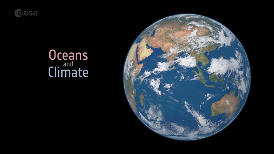 Video:
00:03:33
Video:
00:03:33
Earth’s oceans are huge heat stores, soaking up 93% of the excess heat from human activity over the past 70 years. Ocean currents redistribute heat around the planet, from the Equator to the poles. Where this ocean heat goes influences weather patterns and regional climate. As well as absorbing heat, oceans are a natural carbon sink, absorbing a quarter of carbon dioxide emissions from human activity. This has led to the acidification of ocean water, threating marine life.
The amount of heat and carbon dioxide absorbed depends on a number of ocean variables, all of which can be measured from space.
Taking climate monitoring into the future with quantum
26.5.2022 17:00 ESA Observing the Earth
Over the last decades, satellites measuring the many aspects of Earth have certainly demonstrated their worth with the information they yield to understand and monitor our environment and, importantly, to provide undeniable evidence of climate change for policymaking. While Europe is currently firmly placed as a world leader in Earth observation, it’s critical to stay ahead of the game by examining how even more sophisticated space technologies can be developed to return even more precise information in the future. Today, at ESA’s Living Planet Symposium, being held in Bonn, scientists dug deep into the potential of spaceborne quantum gravity sensors to do just this.
Taking climate monitoring into the future with quantum
26.5.2022 17:00 ESA Observing the Earth
Over the last decades, satellites measuring the many aspects of Earth have certainly demonstrated their worth with the information they yield to understand and monitor our environment and, importantly, to provide undeniable evidence of climate change for policymaking. While Europe is currently firmly placed as a world leader in Earth observation, it’s critical to stay ahead of the game by examining how even more sophisticated space technologies can be developed to return even more precise information in the future.
Today, at ESA’s Living Planet Symposium, being held in Bonn, scientists dug deep into the potential of spaceborne quantum gravity sensors to do just this.
HawkEye 360 Launches Next-Generation Cluster 5 Satellites
26.5.2022 15:45 GISCafe.com Webcasts-Webinars HERNDON, Va., May 25, 2022 — (PRNewswire) — HawkEye 360 Inc., the world's leading commercial provider of space-based radio frequency …ICEYE successfully completes its largest satellite launch ever, placing five new SAR satellites into orbit
26.5.2022 15:45 GISCafe.com Webcasts-Webinars HELSINKI, Finland and IRVINE, Calif., May 26, 2022 — (PRNewswire) — ICEYE, the global leader in persistent monitoring with radar …Omnispace Spark-2™ Satellite Successfully Launches into Orbit
26.5.2022 15:45 GISCafe.com Webcasts-Webinars TYSONS, Va. and TOULOUSE, France, May 26, 2022 — (PRNewswire) — Omnispace and Thales Alenia Space, a joint venture between Thales (67%) …Northeast Utility Selects NV5 for $25 Million LNG Infrastructure Upgrade
26.5.2022 15:44 GISCafe.com Webcasts-Webinars HOLLYWOOD, Fla., May 26, 2022 (GLOBE NEWSWIRE) -- NV5 Global, Inc. (the “Company” or “NV5”) (Nasdaq: NVEE), a provider of technology, …Satellogic Announces Successful Launch of Four Additional Satellites on SpaceX Transporter-5 Mission
26.5.2022 15:44 GISCafe.com Webcasts-Webinars Company Increases Fleet to 26 Operational Satellites, On Track for Weekly Remapping of the Entire Surface of the Earth in 2023NEW YORK — …
Introducing Mapware Fly for DJI Drones: Automated Flight Planning, Flight Control & Capture for Accurate, Detailed 3D Mapping
26.5.2022 15:44 GISCafe.com Webcasts-Webinars WASHINGTON, May 26, 2022 — (PRNewswire) —New, free Android app lets anyone reliably capture landscapes and points of interest for …
Lovte stromy jako pokémony s aplikací Tree Check (TZ)
26.5.2022 13:50 GISportal.cz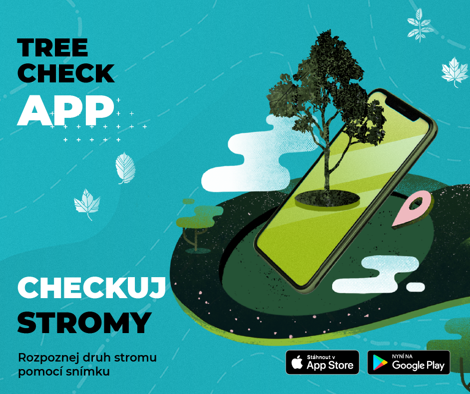
Květnové dny lákají k procházkám, které si můžeme zpříjemnit posezením pod rozkvetlými stromy. Díky nové mobilní aplikaci Tree Check můžeme navíc o stromu, pod nímž se nacházíme, zjistit mnohem více. Aplikace díky umělé inteligenci po vyfocení rozpozná, o jaký druh stromu se jedná. Pracuje na principu 3D scanneru, který využívá vestavěnou kameru v telefonu. Na základě […]
The post Lovte stromy jako pokémony s aplikací Tree Check (TZ) appeared first on GISportal.cz.
Lovte stromy jako pokémony s aplikací Tree Check (TZ)
26.5.2022 13:50 GISportal.czKvětnové dny lákají k procházkám, které si můžeme zpříjemnit posezením pod rozkvetlými stromy. Díky nové mobilní aplikaci Tree Check můžeme navíc o stromu, pod nímž se nacházíme, zjistit mnohem více. Aplikace díky umělé inteligenci po vyfocení rozpozná, o jaký druh stromu se jedná. Pracuje na principu 3D scanneru, který využívá vestavěnou kameru v telefonu. Na základě […]
The post Lovte stromy jako pokémony s aplikací Tree Check (TZ) appeared first on GISportal.cz.
Water cycle
26.5.2022 12:47 ESA Observing the Earth Video:
00:03:23
Video:
00:03:23
Imagine the world without water: as cold and lifeless as the planet Mars. Earth is unique in our solar system in being able to sustain liquid water on its surface. Water is essential for life and for Earth’s climate, helping transport heat around the planet, but it is difficult to track through the whole water cycle. The global view offered by satellites helps. ESA’s Climate Change Initiative is looking at a range of climate variables linked to the water cycle.
Putting the future in FutureEO
26.5.2022 12:45 ESA Observing the Earth
With scientific excellence at the very heart of ESA’s FutureEO programme, participants at this week’s Living Planet Symposium have been making it clear that new research missions to advance Earth science must continue to be realised in the future.
referent KN – právník do právního oddělení XI.
26.5.2022 11:28 ČÚZK - volná místa Katastrální úřad pro hlavní město Prahu - Katastrální pracoviště Praha vypisuje výběrové řízení na místo referent KN – právník do právního oddělení XI.referent KN – právník do právního oddělení XI.
26.5.2022 11:28 ČÚZK - předpisy a opatření Katastrální úřad pro hlavní město Prahu - Katastrální pracoviště Prahavypisuje výběrové řízení na místo
referent KN – právník do právního oddělení XI.
20220526_Vrchní referent / rada oddělení obnovy a revize KN
26.5.2022 10:48 ČÚZK - předpisy a opatření Katastrální úřad pro Středočeský kraj - Katastrální pracoviště Praha-západ Vyhlášení výběrového řízení: Vrchní referent / rada oddělení obnovy a revize KN V části "Úřední deska", v sekci "Oznámení a jiná úřední sdělení" bylo vystaveno "Oznámení o vyhlášení výběrového řízení na obsazení služebního místa Vrchní referent / rada oddělení obnovy a revize KN "20220526_Vrchní referent / rada oddělení obnovy a revize KN
26.5.2022 10:48 ČÚZK /Urady/Katastralni-urady/Katastralni-urady/Katastralni-urad-pro-Stredocesky-kraj/Katastralni-pracoviste/KP-Praha-zapad/O-uradu/Aktuality/20210922_Odborny-referent-oddeleni-aktualizace-(6)Vrchní referent / rada oddělení obnovy a revize KN
26.5.2022 10:41 ČÚZK - volná místa Katastrální úrad pro Středočeský kraj Katastrální pracoviště Praha-západ vypisuje výběrové řízení na místo Vrchní referent / rada oddělení obnovy a revize KNVrchní referent / rada oddělení obnovy a revize KN
26.5.2022 10:41 ČÚZK - předpisy a opatření Katastrální úrad pro Středočeský kraj Katastrální pracoviště Praha-západvypisuje výběrové řízení na místo
Vrchní referent / rada oddělení obnovy a revize KN
Vrchní referent / rada oddělení obnovy a revize KN
26.5.2022 10:41 ČÚZK /Urady/Katastralni-urady/Katastralni-urady/Katastralni-urad-pro-Stredocesky-kraj/Uredni-deska/Oznameni-a-jina-uredni-sdeleni/Volna-mista/DMS/Vrchni-referent-rada-oddeleni-obnovy-a-revize-KNŘízení letového provozu spustilo tzv. Grid (dlaždice) pro CTR a MCTR se znázorněním ochranných pásem a maximálních povolených výšek pro drony
26.5.2022 10:33 UAVAŘízení letového provozu (ŘLP) spustilo ve zkušebním provozu na stránkách https://dronview.rlp.cz/ pro CTR a MCTR tzv. Grid (dlaždice), které jasně graficky znázorňují průběh ochranných pásem řízených letišť a hodnoty udávají maximální výšku nad zemí, která nesmí být provozem dronu v daném obdélníku překročena bez předchozí koordinace s ŘLP. Tuto vrstvu spustíte tlačítkem Grid v levém […]
The post Řízení letového provozu spustilo tzv. Grid (dlaždice) pro CTR a MCTR se znázorněním ochranných pásem a maximálních povolených výšek pro drony appeared first on UAV Aliance pro bezpilotní letecký průmysl.
Aktualizace prohlížecí služby WMTS ZABAGED®
26.5.2022 10:00 ČÚZK - Geoportál Aktualizace prohlížecí služby WMTS ZABAGED®Prohlížecí služba WMTS ZABAGED®, vytvořená za účelem poskytování podkladové mapy s rychlým překreslováním z předpřipravených mapových dlaždic, již poskytuje veškeré změny po dubnové aktualizaci datové sady ZABAGED®.
Již dříve (souběžně s aktualizací) byly aktualizovány dynamické prohlížecí služby ZABAGED®, ZABAGED® (vizualizace nad ortofoto), ZABAGED® (vizualizace ZM10) poskytující obraz dat ZABAGED® přímo z publikační databáze.
Aktualizace prohlížecí služby WMTS ZABAGED®
26.5.2022 10:00 ČÚZK - Geoportál Aktualizace prohlížecí služby WMTS ZABAGED®Prohlížecí služba WMTS ZABAGED®, vytvořená za účelem poskytování podkladové mapy s rychlým překreslováním z předpřipravených mapových dlaždic, již poskytuje veškeré změny po dubnové aktualizacidatové sady ZABAGED®.
Již dříve (souběžně s aktualizací) byly aktualizovány dynamické prohlížecí služby ZABAGED®, ZABAGED® (vizualizace nad ortofoto) ZABAGED® (vizualizace ZM10) poskytující obraz dat ZABAGED® přímo z publikační databáze.
Aktualizace prohlížecí služby WMTS ZABAGED®
26.5.2022 10:00 ČÚZK - Geoportál Aktualizace prohlížecí služby WMTS ZABAGED®Prohlížecí služba WMTS ZABAGED®, vytvořená za účelem poskytování podkladové mapy s rychlým překreslováním z předpřipravených mapových dlaždic, již poskytuje veškeré změny po dubnové aktualizaci datové sady ZABAGED®.
Již dříve (souběžně s aktualizací) byly aktualizovány dynamické prohlížecí služby ZABAGED®, ZABAGED® (vizualizace nad ortofoto), ZABAGED® (vizualizace ZM10) poskytující obraz dat ZABAGED® přímo z publikační databáze.
Aktualizace prohlížecí služby WMTS ZABAGED®
26.5.2022 10:00 ČÚZK - Geoportál Aktualizace prohlížecí služby WMTS ZABAGED®Prohlížecí služba WMTS ZABAGED®, vytvořená za účelem poskytování podkladové mapy s rychlým překreslováním z předpřipravených mapových dlaždic, již poskytuje veškeré změny po dubnové aktualizaci datové sady ZABAGED®.
Již dříve (souběžně s aktualizací) byly aktualizovány dynamické prohlížecí služby ZABAGED®, ZABAGED® (vizualizace nad ortofoto), ZABAGED® (vizualizace ZM10) poskytující obraz dat ZABAGED® přímo z publikační databáze.
20220526_Rada / odborný rada oddělení aktualizace GI KN
26.5.2022 9:51 ČÚZK /Urady/Katastralni-urady/Katastralni-urady/Katastralni-urad-pro-Stredocesky-kraj/Katastralni-pracoviste/KP-Praha-zapad/O-uradu/Aktuality/20210922_Odborny-referent-oddeleni-aktualizace-(5)20220526_Odborný / vrchní referent oddělení právních vztahů k nemovitostem
26.5.2022 9:51 ČÚZK /Urady/Katastralni-urady/Katastralni-urady/Katastralni-urad-pro-Stredocesky-kraj/Katastralni-pracoviste/KP-Praha-zapad/O-uradu/Aktuality/20210922_Odborny-referent-oddeleni-aktualizace-(5)20220526_Rada / odborný rada oddělení aktualizace GI KN
26.5.2022 9:51 ČÚZK - předpisy a opatření Katastrální úřad pro Středočeský kraj - Katastrální pracoviště Praha-západ Vyhlášení výběrového řízení: Rada / odborný rada oddělení aktualizace GI KN V části "Úřední deska", v sekci "Oznámení a jiná úřední sdělení" bylo vystaveno "Oznámení o vyhlášení výběrového řízení na obsazení služebního místa Rada / odborný rada oddělení aktualizace GI KN "Rada / odborný rada oddělení aktualizace GI KN
26.5.2022 9:48 ČÚZK /Urady/Katastralni-urady/Katastralni-urady/Katastralni-urad-pro-Stredocesky-kraj/Uredni-deska/Oznameni-a-jina-uredni-sdeleni/Volna-mista/DMS/Rada-odborny-rada-oddeleni-aktualizace-GI-KNRada / odborný rada oddělení aktualizace GI KN
26.5.2022 9:48 ČÚZK - předpisy a opatření Katastrální úrad pro Středočeský kraj Katastrální pracoviště Praha-západvypisuje výběrové řízení na místo
Rada / odborný rada oddělení aktualizace GI KN
Rada / odborný rada oddělení aktualizace GI KN
26.5.2022 9:48 ČÚZK - volná místa Katastrální úrad pro Středočeský kraj Katastrální pracoviště Praha-západ vypisuje výběrové řízení na místo Rada / odborný rada oddělení aktualizace GI KN20220526_Odborný / vrchní referent oddělení právních vztahů k nemovitostem
26.5.2022 9:12 ČÚZK - předpisy a opatření Katastrální úřad pro Středočeský kraj - Katastrální pracoviště Příbram Vyhlášení výběrového řízení: Odborný / vrchní referent oddělení právních vztahů k nemovitostem V části "Úřední deska", v sekci "Oznámení a jiná úřední sdělení" bylo vystaveno "Oznámení o vyhlášení výběrového řízení na obsazení služebního místa Odborný / vrchní referent oddělení právních vztahů k nemovitostem"20220526_Odborný / vrchní referent oddělení právních vztahů k nemovitostem
26.5.2022 9:12 ČÚZK /Urady/Katastralni-urady/Katastralni-urady/Katastralni-urad-pro-Stredocesky-kraj/Katastralni-pracoviste/KP-Pribram/O-uradu/Aktuality/20210922_Odborny-referent-oddeleni-aktualizace-(5)Odborný / vrchní referent oddělení právních vztahů k nemovitostem
26.5.2022 9:07 ČÚZK - volná místa Katastrální úrad pro Středočeský kraj Katastrální pracoviště Příbram vypisuje výběrové řízení na místo Odborný / vrchní referent oddělení právních vztahů k nemovitostemOdborný / vrchní referent oddělení právních vztahů k nemovitostem
26.5.2022 9:07 ČÚZK - předpisy a opatření Katastrální úrad pro Středočeský kraj Katastrální pracoviště Příbramvypisuje výběrové řízení na místo
Odborný / vrchní referent oddělení právních vztahů k nemovitostem
Odborný / vrchní referent oddělení právních vztahů k nemovitostem
26.5.2022 9:07 ČÚZK /Urady/Katastralni-urady/Katastralni-urady/Katastralni-urad-pro-Stredocesky-kraj/Uredni-deska/Oznameni-a-jina-uredni-sdeleni/Volna-mista/DMS/Odborny-vrchni-referent-oddeleni-pravnich-vztahWhat can satellites reveal about climate tipping points?
26.5.2022 9:01 ESA Observing the Earth
The effects of our warming climate are seen across a multitude of measures, usually as incremental changes: more frequent extreme weather, heatwaves, droughts and wildfires. The cumulative impact of these changes, however, can cause fundamental parts of the Earth system to change more quickly and drastically. These ‘tipping points’ are thresholds where a tiny change pushes the system into an entirely new state.
This week, at ESA’s Living Planet Symposium, scientists came together to discuss the latest research evidence for climate tipping points and identify the opportunities and challenges of using remote sensing data to understand them.
Interview with Lori DeMatteis, Global VP Customer Success, Iris Automation
26.5.2022 9:00 GISCafe.com Webcasts-WebinarsD-Orbit Launches its Sixth ION Satellite Carrier Mission
26.5.2022 1:44 GISCafe.com Webcasts-Webinars FINO MORNASCO, Italy, May 25, 2022 (GLOBE NEWSWIRE) -- D-Orbit, the space logistics and orbital transportation company in the process of going …Drones that deliver critical medical supplies coming to Brazil
25.5.2022 17:21 GISCafe.com Webcasts-Webinars DENVER, CO., May 24, 2022 (GLOBE NEWSWIRE) -- Spright, the new drone division of Air Methods, and Synerjet Corp, a specialist in business aviation …BlackSky Awarded 10-Year Electro Optical Commercial Layer (EOCL) Contract with U.S. Government
25.5.2022 17:21 GISCafe.com Webcasts-Webinars The National Reconnaissance Office selected BlackSky to deliver advanced high frequency imagery servicesHERNDON, Va. — (BUSINESS WIRE) — …
Satellogic to Participate at Upcoming Investor Conferences in June
25.5.2022 17:21 GISCafe.com Webcasts-Webinars Baird 2022 Global Consumer, Technology & Services Conference in New York City June 6-8, 2022LD Micro Invitational XII Conference in Westlake …
NRO Awards Maxar a 10-Year Contract Under the Electro-Optical Commercial Layer Acquisition
25.5.2022 17:21 GISCafe.com Webcasts-Webinars WESTMINSTER, Colo. — (BUSINESS WIRE) — May 25, 2022 —Maxar Technologies (NYSE:MAXR)(TSX:MAXR), a trusted partner and innovator in …
Historic Greenland ice sheet rainfall unravelled
25.5.2022 15:30 ESA Observing the Earth
For the first time ever recorded, in the late summer of 2021, rain fell on the high central region of the Greenland ice sheet. This extraordinary event was followed by the surface snow and ice melting rapidly. Researchers now understand exactly what went on in those fateful summer days and what we can learn from it.
From Rome to Bonn by bike
25.5.2022 13:55 ESA Observing the Earth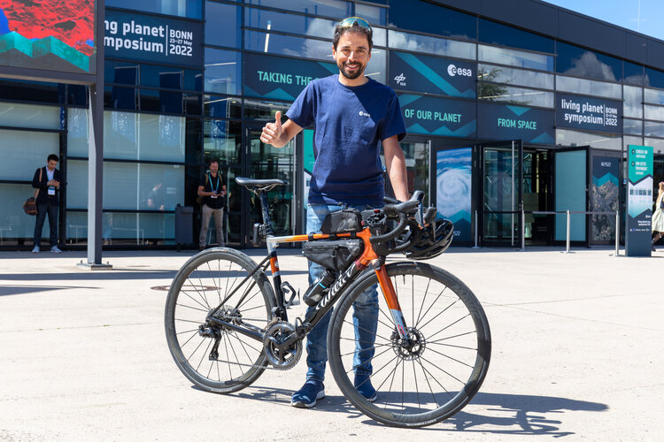 Image:
Omar di Felice, an extreme cyclist, has biked from Rome to Bonn to take part at ESA’s Living Planet Symposium. Tune in today at 15:30 live from Bonn on ESA Earth Observation Instagram as he’s joined by ESA Astronaut Luca Parmitano and ESA CryoSat Mission Geophysicist Alessandro di Bella.
Image:
Omar di Felice, an extreme cyclist, has biked from Rome to Bonn to take part at ESA’s Living Planet Symposium. Tune in today at 15:30 live from Bonn on ESA Earth Observation Instagram as he’s joined by ESA Astronaut Luca Parmitano and ESA CryoSat Mission Geophysicist Alessandro di Bella.
From Rome to Bonn by bike
25.5.2022 13:55 ESA Observing the Earth
Image:
Omar Di Felice, an extreme cyclist, has biked from Rome to Bonn to take part at ESA’s Living Planet Symposium. Tune in today at 15:30 live from Bonn on ESA Earth Observation Instagram as he’s joined by ESA Astronaut Luca Parmitano and ESA CryoSat Mission Geophysicist Alessandro di Bella.
Informácie pre používateľov Portálu ESKN
25.5.2022 12:50
ÚGKK SR
Na základe odozvy používateľov za prvé 3 týždne prevádzky nového Portálu elektronických služieb katastra nehnuteľností (ESKN) po vypnutí staršieho Katastrálneho portálu (KaPor) sme pripravili niekoľko informácií pre používateľov. Ide o niektoré rady pri používaní Portálu ESKN alebo dôležité informácie či vysvetlenie problémov.
Informácie pre používateľov Portálu ESKN
25.5.2022 12:50 ÚGKK SRNa základe odozvy používateľov za prvé 3 týždne prevádzky nového Portálu elektronických služieb katastra nehnuteľností (ESKN) po vypnutí staršieho Katastrálneho portálu (KaPor) sme pripravili niekoľko informácií pre používateľov. Ide o niektoré rady pri používaní Portálu ESKN alebo dôležité informácie či vysvetlenie problémov.
Informácie pre používateľov Portálu ESKN
25.5.2022 12:50
ÚGKK SR
Na základe odozvy používateľov za prvé 3 týždne prevádzky nového Portálu elektronických služieb katastra nehnuteľností (ESKN) po vypnutí staršieho Katastrálneho portálu (KaPor) sme pripravili niekoľko informácií pre používateľov. Ide o niektoré rady pri používaní Portálu ESKN alebo dôležité informácie či vysvetlenie problémov.
Upozornění
25.5.2022 12:45 ČÚZK - předpisy a opatření Katastrální úřad pro Liberecký kraj zveřejnil novou aktualitu: Upozornění - dne 23. 5. 2022 došlo k odcizení služebních průkazů, více informací zde.Upozornění
25.5.2022 12:45 ČÚZK /Urady/Katastralni-urady/Katastralni-urady/Katastralni-urad-pro-Liberecky-kraj/O-uradu/Aktuality/Upozorneni
Odstávka Portálu ESKN
25.5.2022 12:40
ÚGKK SR
Dňa 26.05.2021 /štvrtok/ bude v čase od 21:00 hod. do 22:00 hod. plánovaná technická odstávka Portálu ESKN /aktualizácia systému/. Z uvedeného dôvodu nebudú v uvedenom čase dostupné elektronické služby katastra nehnuteľností pre verejnosť.
Za vzniknuté problémy sa ospravedlňujeme.
Supporting the Paris Agreement from space
25.5.2022 12:15 ESA Observing the Earth
Earth observation is already capable of supporting national climate action, but there are many more opportunities on the horizon, according to discussions today among leading scientists and policymakers at ESA’s Living Planet Symposium being held in Bonn, Germany.
Entrepreneurship Day a not-to-be-missed event for start-ups, scale-ups, innovators and investors
25.5.2022 11:43 European GNSS Agency
If you’re a European start-up, scale-up, SME, entrepreneur, innovator or investor and aren’t taking advantage of the EU Space Programme then listen up: you’re missing out on a big opportunity.
Just how big are we talking?
According to research conducted by the experts at the EU Agency for the Space Programme (EUSPA), the GNSS and Earth Observation downstream market generated over EUR 200 billion in revenue in 2021. What’s more, this market is expected to hit the half trillion mark over the next decade.
Now that we have your attention, it’s time to take out your calendar and circle 1 June. That’s the day EUSPA will provide all the information and insight you need to successfully integrate European space solutions into your business idea, start-up or innovation.
Taking place at EUSPA Headquarters in Prague, Entrepreneurship Day is a chance to learn about the EU Space Programme and how EUSPA supports those looking to innovate and invest using European GNSS and Earth Observation. It’s also an opportunity to get a first-hand look at how innovative space-based solutions are delivering cutting-edge, often industry-defining services across a range of application areas – many of which will be exhibiting during the event as part of the #myEUspace competition.
Bringing space-solutions onto the European market
Organised by EUSPA as part of the European Commission’s CASSINI - Space Entrepreneurship Initiative, the #myEUspace competition has committed EUR 1 million in prize money to bring disruptive, space-based solutions onto the European market. The accelerated start-ups developed a range of novel solutions, new technologies, mobile apps and hardware. While each solution covers a different sector, including location-based services, smart mobility, geomatics and smart agriculture, they all share a foundation in their use of data coming from Galileo and/or Copernicus.
“Space data is at the heart of the technological revolution currently sweeping Europe, and this competition is another example of how EUSPA supports innovative entrepreneurs, start-ups and SMEs from across the EU who are leveraging Copernicus and Galileo data, information and services,” says Fiammetta Diani, EUSPA Head of Market, Downstream and Innovation.
Nearly 40 EU start-ups will be on hand at Entrepreneurship Day to share how their space-based innovations support the EU’s strategic agenda. The start-ups will also provide live demonstrations as part of their final pitch to judges, who will announce the winners of the #myEUspace competition at the end of the day.
Information for fund managers and investors too
Entrepreneurship Day will also host the latest edition of our Capacity Building for Fund Managers series.
Organised by EUSPA, in collaboration with the European Commission, European Space Agency (ESA) and European Investment Fund (EIF), this series of five workshops is designed to provide venture capitalists, fund managers and other investors with the in-depth information they need to make smart, informed investment decisions.
“If you want to become an active investor in this exciting field or simply want to gather more information before deciding to raise a new fund, then this capacity building programme is for you,” adds Diani.
The workshop will be held live during Entrepreneurship Day, as well as online.
A focus on start-ups
On top of the start-up showcase, the #myEUspace competition and the Capacity Building workshop, the Entrepreneurship Day agenda will feature panel discussions on how to grow a start-up and best practices in start-up investment.
“Because of their agility and unique ability to adjust to new business models and adapt to new technologies, start-ups are particularly well-positioned to leverage the potential offered by the EU Space Programme,” notes Diani.
The day also includes dedicated time for business matchmaking and of course plenty of opportunities for networking.
Join us virtually for the afternoon sessions by tuning in here.
Media note: This feature can be republished without charge provided the European Union Agency for the Space Programme (EUSPA) is acknowledged as the source at the top or the bottom of the story. You must request permission before you use any of the photographs on the site. If you republish, we would be grateful if you could link back to the EUSPA website (http://www.euspa.europa.eu).