


![]()

zprávy
zdroje zpráv:FOTO: Slavnostní vyhlášení výsledků soutěže Mapa roku 2020
14.9.2021 10:47 GeoBusinessČeská kartografická společnost uspořádala v pořadí již 23. ročník soutěže Mapa roku, ve které odborná porota vybrala z přihlášených kartografických děl ta nejlepší. Slavnostní vyhlášení výsledků soutěže se konalo za účasti široké kartografické komunity ve čtvrtek 9. září 2021 na společenském večeru 24. kartografické konference v Ostravě. Vít Voženílek, zakladatel soutěže Mapa roku a současný viceprezident pořádající České kartografické společnosti, představuje výsledky. […]
The post FOTO: Slavnostní vyhlášení výsledků soutěže Mapa roku 2020 appeared first on GeoBusiness.
FOTO: Slavnostní vyhlášení výsledků soutěže Mapa roku 2020
14.9.2021 10:47 GeoBusinessČeská kartografická společnost uspořádala v pořadí již 23. ročník soutěže Mapa roku, ve které odborná porota vybrala z přihlášených kartografických děl ta nejlepší. Slavnostní vyhlášení výsledků soutěže se konalo za účasti široké kartografické komunity ve čtvrtek 9. září 2021 na společenském večeru 24. kartografické konference v Ostravě. Vít Voženílek, zakladatel soutěže Mapa roku a současný viceprezident pořádající České […]
The post FOTO: Slavnostní vyhlášení výsledků soutěže Mapa roku 2020 appeared first on GeoBusiness.
Announcing Earth observation hackathon winners
14.9.2021 10:00 ESA Observing the Earth
In June 2021, more than 4300 participants from 132 countries and territories came together to solve challenges related to the COVID-19 pandemic. ESA, NASA and the Japan Aerospace Exploration Agency (JAXA) are pleased to announce CleverChart and TRACER as the winners of the Open Science Award.
Oznámení o výběru zástupu na služební místo odborný/vrchní referent – obnova katastrálního operátu
14.9.2021 8:37 ČÚZK /Urady/Katastralni-urady/Katastralni-urady/Katastralni-urad-pro-Plzensky-kraj/O-uradu/Aktuality/Oznameni-o-vyberu-zastupu-na-sluzebni-misto-odbornOznámení o výběru zástupu na služební místo odborný/vrchní referent – obnova katastrálního operátu
14.9.2021 8:37 ČÚZK - předpisy a opatření Katastrální úřad pro Plzeňský kraj - Katastrální pracoviště Domažlice zveřejnil novou aktualitu: KÚ pro Plzeňský kraj vybírá zástup na služební místo odborný/vrchní referent – obnova katastrálního operátu OKO0409 - KP Domažlice.Oznámení o výběru zástupu na služební místo odborný/vrchní referent – obnova katastrálního operátu O
14.9.2021 8:30 ČÚZK - předpisy a opatření Katastrální úřad pro Plzeňský kraj Katastrální pracoviště Domažlicevypisuje výběrové řízení na místo
Oznámení o výběru zástupu na služební místo odborný/vrchní referent – obnova katastrálního operátu OKO0409
Oznámení o výběru zástupu na služební místo odborný/vrchní referent – obnova katastrálního operátu O
14.9.2021 8:30 ČÚZK /Urady/Katastralni-urady/Katastralni-urady/Katastralni-urad-pro-Plzensky-kraj/Uredni-deska/Oznameni-a-jina-uredni-sdeleni/Volna-mista/DMS/Oznameni-o-vyberu-zastupu-na-sluzebni-misto-odbornOznámení o výběru zástupu na služební místo odborný/vrchní referent – obnova katastrálního operátu O
14.9.2021 8:30 ČÚZK - volná místa Katastrální úřad pro Plzeňský kraj Katastrální pracoviště Domažlice vypisuje výběrové řízení na místo Oznámení o výběru zástupu na služební místo odborný/vrchní referent – obnova katastrálního operátu OHexagon introduces Security & Surveillance portfolio for rail
14.9.2021 5:30 Hexagon Safety & InfrastructureSkycatch Launches Proprietary 3D and 4D Software for the M300 at MINExpo, Delivering End to End Power and 24x Faster Data Processing at the Edge
14.9.2021 3:43 GISCafe.com Webcasts-Webinars SAN FRANCISCO, Sept. 13, 2021 — (PRNewswire) — Skycatch, an industrial end-to-end data automation solution company, today …Illinois DOT Deploys CompassCom for Snow Fighting and Emergency Traffic Patrol Assets on the STARCOM 21 Radio Network
13.9.2021 23:56 GISCafe.com Webcasts-Webinars DENVER, CO – August 14, 2021 –CompassCom is pleased to announce that the Illinois Department of Transportation (IDOT) has deployed …UN-GGIM marks a decade of global cooperation in unlocking the value of location-based data
13.9.2021 20:28 GISCafe.com Webcasts-Webinars Globally adopted frameworks developed in the first decade of the United Nations Committee of Experts on Global Geospatial Information Management …Nové verze 15.25 našich produktů
13.9.2021 18:23 GEPROPřipravili jsme pro vás nové verze 15.25 našich produktů. Stahovat je můžete z obvyklého umístění na našem download serveru:
… >>
Juzhen Data Tech Selects Ouster Digital Lidar for Its Autonomous Electric Delivery Vehicles
13.9.2021 17:07 GISCafe.com Webcasts-Webinars Agreement includes potential demand for 1,190 Ouster lidar sensors through 2025 as Juzhen scales production of its next-generation delivery …Tower Semiconductor Announces Breakthrough LiDAR Technology for Advanced Driver-Assistance Systems
13.9.2021 17:07 GISCafe.com Webcasts-Webinars Utilizing Tower’s advanced SiPho technology platform, innovation provides a compact solid-state electronically scanning LiDAR solution with superb …Luokung Announces eMapGo to Provide Community Information Management and Technical Services for Heilongjiang Mobile
13.9.2021 17:07 GISCafe.com Webcasts-Webinars BEIJING, Sept. 13, 2021 — (PRNewswire) — Luokung Technology Corp. (NASDAQ: LKCO) ("Luokung" or the "Company"), a leading …Kratos Receives $338 Million Sole Source Contract Award for Target Drones from U.S. Air Force
13.9.2021 17:07 GISCafe.com Webcasts-Webinars SAN DIEGO, Sept. 13, 2021 (GLOBE NEWSWIRE) -- Kratos Defense & Security Solutions, Inc. (NASDAQ: KTOS), a leading National Security Solutions …Woolpert Utilizes Esri Technology to Launch AirportWorX Application Portal
13.9.2021 17:07 GISCafe.com Webcasts-Webinars The GIS-based solution enables airports to efficiently manage work orders, inspections and leases.DAYTON, Ohio, Sept. 13, 2021 — (PRNewswire) …
rada/odborný rada – rozhodování o povolení vkladu v oddělení právních vztahů k nemovitostem Katastrá
13.9.2021 13:46 ČÚZK - volná místa Katastrální úřad pro Jihočeský kraj Katastrální pracoviště Strakonice vypisuje výběrové řízení na místo rada/odborný rada – rozhodování o povolení vkladu v oddělení právních vztahů k nemovitostem Katastrárada/odborný rada – rozhodování o povolení vkladu v oddělení právních vztahů k nemovitostem Katastrá
13.9.2021 13:46 ČÚZK - předpisy a opatření Katastrální úřad pro Jihočeský kraj Katastrální pracoviště Strakonicevypisuje výběrové řízení na místo
rada/odborný rada – rozhodování o povolení vkladu v oddělení právních vztahů k nemovitostem Katastrálního pracoviště Strakonice (ID SM 30000279/30003903)
odborný/vrchní referent – kontrola aktualizace v oddělení právních vztahů k nemovitostem Katastrální
13.9.2021 13:25 ČÚZK - předpisy a opatření Katastrální úřad pro Jihočeský kraj Katastrální pracoviště Strakonicevypisuje výběrové řízení na místo
odborný/vrchní referent – kontrola aktualizace v oddělení právních vztahů k nemovitostem Katastrálního pracoviště Strakonice (ID SM 30000285/30003909)
odborný/vrchní referent – kontrola aktualizace v oddělení právních vztahů k nemovitostem Katastrální
13.9.2021 13:25 ČÚZK - volná místa Katastrální úřad pro Jihočeský kraj Katastrální pracoviště Strakonice vypisuje výběrové řízení na místo odborný/vrchní referent – kontrola aktualizace v oddělení právních vztahů k nemovitostem Katastrálníodborný/vrchní referent – kontrola aktualizace v oddělení právních vztahů k nemovitostem Katastrální
13.9.2021 13:25 ČÚZK /Urady/Katastralni-urady/Katastralni-urady/Katastralni-urad-pro-Jihocesky-kraj/Uredni-deska/Oznameni-a-jina-uredni-sdeleni/Volna-mista/DMS/odborny-vrchni-referent-–-kontrola-aktualizace-v-oEUSPA back on the road for a series of September events
13.9.2021 13:05 European GNSS Agency
After a year of digital events, EUSPA greeted autumn with two events in physical format. Startup OLÉ and European Rover Challenger were two great opportunities for EUSPA to showcase EU Space success stories and opportunities to the old and new EU Space community.
Providing satellite-based services to a broad spectrum of industries has always been at the core of EUSPA’s mission. To do so, and to keep abreast of their needs, the agency has since its inception been interacting with users through various fora, consultation platforms, industry days and exhibitions. While last year found our EUSPA teams wired to digital events, this September our colleagues hit the road to introduce our revamped agency to the EU Space community.
‘’Engaging in live events with users whose businesses and operations rely on GNSS and EO data, is pivotal for the development of a robust downstream space sector. EUSPA stays in the know by closely monitoring market trends and adapting, devising and implementing strategic plans that guarantee the market uptake of the EU Space Programme,’’ says Fiammetta Diani, Head of Market Development at EUSPA. ‘’Every year, we try to participate at events across Europe to bring ‘’more space’’ to entrepreneurship and innovation,’’ concludes Diani.
While observing all the necessary hygiene measures, our EUSPA team flew to Salamanca, Spain and Kielc, Poland for two special events:
Sparking space entrepreneurship at Startup OLÉ
Held in Salamanca, Startup OLÉ is a conference that brings together start-ups, accelerators, investors, and public institutions, and through activities such as matchmaking, panels and roundtables, helps them develop synergies and secure financing opportunities. EUSPA hosted a panel on innovative solutions driven by space data, which featured Marco Nisi, Head of Integrated space-based solutions at Sistematica S.p.A. and CEO of SARA Project and Iñigo Adin, Director of the Electronic Systems and Communications Group at CEIT (Centro de Estudios e Investigaciones Técnicas de Gipuzkoa) as main speakers. Both Nisi and Adin talked about their experience with developing projects under the H2020 funding mechanism, challenges and lessons learned.
Quotes:
Mike Rhodes, CEO at Allerayde and previous participant in #MyGalileoSolution competition explained how thanks to EUSPA he managed to develop a prototype much faster and why such innovation competitions are a great booster for start-ups.
#EUSpace robotic solutions turning the planet greener
The European Rover Challenge is a prestigious space and robotics event combining international competitions of mobile robots with scientific and technological shows. Sunday September 12th was dedicated to robotic solutions and Earth protection. Justyna Redełkiewicz, Head of Sector LBS, Market & Technology at EUSPA presented the agency’s new scope as well as the key contributions of the EU Space Programme to environmental protection.
From IoT and Augmented Reality to autonomous robotic systems, space data is enabling many of the current market and tech trends. Robotics rely on various sources to position themselves and navigate ranging from LiDAR sensors to GNSS data. The contribution of Galileo’s positioning services and the extra precision guaranteed by EGNOS help robotic applications optimise their routes and thus calibrate their overall performance.
In the past, EUSPA has funded various robotic ideas some of which include, GreenPatrol, a robotic solution for Integrated Pest Management in Greenhouses, and 10Lines, a Galileo-enabled autonomous parking lot solution. 10Lines robots can strip parking lots seven times faster than current processes, requiring less supervision, eliminating the time-consuming measuring and pre-marking phases while significantly reducing CO2 emissions.
Next stop…Copenhagen for Tech BBQ (Denmark, 16th and 17th of September): the festival for tech start-ups and entrepreneurs to promote innovation and technology in the Nordic start-up ecosystem.
See you all there!
Media note: This feature can be republished without charge provided the European Union Agency for the Space Programme (EUSPA) is acknowledged as the source at the top or the bottom of the story. You must request permission before you use any of the photographs on the site. If you republish, we would be grateful if you could link back to the EUSPA website (http://www.euspa.europa.eu).
EUSPA back on the road for a series of September events
13.9.2021 13:05 European GNSS AgencyAfter a year of digital events, EUSPA greeted autumn with two events in physical format. Startup OLÉ and European Rover Challenger were two great opportunities for EUSPA to showcase EU Space success stories and opportunities to the old and new EU Space community.
Providing satellite-based services to a broad spectrum of industries has always been at the core of EUSPA’s mission. To do so, and to keep abreast of their needs, the agency has since its inception been interacting with users through various fora, consultation platforms, industry days and exhibitions. While last year found our EUSPA teams wired to digital events, this September our colleagues hit the road to introduce our revamped agency to the EU Space community.
‘’Engaging in live events with users whose businesses and operations rely on GNSS and EO data, is pivotal for the development of a robust downstream space sector. EUSPA stays in the know by closely monitoring market trends and adapting, devising and implementing strategic plans that guarantee the market uptake of the EU Space Programme,’’ says Fiammetta Diani, Head of Market Development at EUSPA. ‘’Every year, we try to participate at events across Europe to bring ‘’more space’’ to entrepreneurship and innovation,’’ concludes Diani.
While observing all the necessary hygiene measures, our EUSPA team flew to Salamanca, Spain and Kielc, Poland for two special events:
Sparking space entrepreneurship at Startup OLÉ
Held in Salamanca, Startup OLÉ is a conference that brings together start-ups, accelerators, investors, and public institutions, and through activities such as matchmaking, panels and roundtables, helps them develop synergies and secure financing opportunities. EUSPA hosted a panel on innovative solutions driven by space data, which featured Marco Nisi, Head of Integrated space-based solutions at Sistematica S.p.A. and CEO of SARA Project and Iñigo Adin, Director of the Electronic Systems and Communications Group at CEIT (Centro de Estudios e Investigaciones Técnicas de Gipuzkoa) as main speakers. Both Nisi and Adin talked about their experience with developing projects under the H2020 funding mechanism, challenges and lessons learned.
Mike Rhodes, CEO at Allerayde and previous participant in #MyGalileoSolution competition explained how thanks to EUSPA he managed to develop a prototype much faster and why such innovation competitions are a great booster for start-ups.
#EUSpace robotic solutions turning the planet greener
The European Rover Challenge is a prestigious space and robotics event combining international competitions of mobile robots with scientific and technological shows. Sunday September 12th was dedicated to robotic solutions and Earth protection. Justyna Redełkiewicz, Head of Sector LBS, Market & Technology at EUSPA presented the agency’s new scope as well as the key contributions of the EU Space Programme to environmental protection.
From IoT and Augmented Reality to autonomous robotic systems, space data is enabling many of the current market and tech trends. Robotics rely on various sources to position themselves and navigate ranging from LiDAR sensors to GNSS data. The contribution of Galileo’s positioning services and the extra precision guaranteed by EGNOS help robotic applications optimise their routes and thus calibrate their overall performance.
In the past, EUSPA has funded various robotic ideas some of which include, GreenPatrol, a robotic solution for Integrated Pest Management in Greenhouses, and 10Lines, a Galileo-enabled autonomous parking lot solution. 10Lines robots can strip parking lots seven times faster than current processes, requiring less supervision, eliminating the time-consuming measuring and pre-marking phases while significantly reducing CO2 emissions.
Next stop…Copenhagen for Tech BBQ (Denmark, 16th and 17th of September): the festival for tech start-ups and entrepreneurs to promote innovation and technology in the Nordic start-up ecosystem.
See you all there!
Media note: This feature can be republished without charge provided the European Union Agency for the Space Programme (EUSPA) is acknowledged as the source at the top or the bottom of the story. You must request permission before you use any of the photographs on the site. If you republish, we would be grateful if you could link back to the EUSPA website (http://www.euspa.europa.eu).
Noc vědců 2021 – vyberte si ze 1429 událostí
13.9.2021 12:40 GeoBusinessNoc vědců, akce oživující v jeden večer stovky vědeckých budov, do kterých se běžný smrtelník nedostane. Návštěvníci proplouvají laboratořemi, přednáškovými místnostmi, vybuchujícími experimenty a jdou do hloubky aktuálních témat. Děti, dospělí, senioři, každý zapálený pro vědu je vítaný. V České republice se Noc vědců koná od roku 2005 a je zastoupena českými univerzitami, vědeckými ústavy, […]
The post Noc vědců 2021 – vyberte si ze 1429 událostí appeared first on GeoBusiness.
Noc vědců 2021 – vyberte si ze 1429 událostí
13.9.2021 12:40 GeoBusinessNoc vědců, akce oživující v jeden večer stovky vědeckých budov, do kterých se běžný smrtelník nedostane. Návštěvníci proplouvají laboratořemi, přednáškovými místnostmi, vybuchujícími experimenty a jdou do hloubky aktuálních témat. Děti, dospělí, senioři, každý zapálený pro vědu je vítaný. V České republice se Noc vědců koná od roku 2005 a je zastoupena českými univerzitami, vědeckými ústavy, hvězdárnami a dalšími institucemi. […]
The post Noc vědců 2021 – vyberte si ze 1429 událostí appeared first on GeoBusiness.
Interaktivní atlas světa od Seznamu jedním z vítězů soutěže Mapa roku 2020
13.9.2021 11:36 ZeměměřičČeská kartografická společnost uspořádala v pořadí již 23. ročník soutěže Mapa roku. Uzávěrka pro přihlášení kartografických děl a výsledků studentských prací byla 31. března 2021 a následující období patřilo podrobnému hodnocení produktů jednotlivými členy hodnotící komise. Ve středu 16. června 2021 se členové komise sešli na Geografickém ústavu Masarykovy univerzity v Brně a po společném jednání stanovili nominace na ocenění Mapa roku 2020. Slavnostní […]
The post Interaktivní atlas světa od Seznamu jedním z vítězů soutěže Mapa roku 2020 appeared first on Zeměměřič.
Skvalitnenie údajov SGI tvorbou implementovaných máp
13.9.2021 11:30
ÚGKK SR
Spustenie verejného obstarávania na tvorbu Vektorovej katastrálnej mapy implementovanej na podklade Transformovanej mapy a Súboru prevzatých meraní - bližšie informácie v časti Kataster nehnuteľností\Aktuality
Omezení výpůjční doby [Knihovna geografie, byTopic]
13.9.2021 11:25 Katedra aplikované geoinformatiky a kartografie Přf UK Zkrácení výpůjční doby.20210902_účetní
13.9.2021 10:39 ČÚZK /Urady/Katastralni-urady/Katastralni-urady/Katastralni-urad-pro-Stredocesky-kraj/O-uradu/Aktuality/20210113_odborny-rada,-reditel-Katastralniho-p-(6)20210902_účetní
13.9.2021 10:39 ČÚZK - předpisy a opatření Katastrální úřad pro Středočeský kraj Vyhlášení výběrového řízení: účetní V části "Úřední deska", v sekci "Oznámení a jiná úřední sdělení" bylo vystaveno "Oznámení o vyhlášení výběrového řízení na obsazení systemizovaného místa účetní v kanceláři ředitele KÚ"20210902_Rada / odborný rada – interní auditor Katastrálního úřadu pro Středočeský kraj
13.9.2021 10:39 ČÚZK /Urady/Katastralni-urady/Katastralni-urady/Katastralni-urad-pro-Stredocesky-kraj/O-uradu/Aktuality/20210113_odborny-rada,-reditel-Katastralniho-p-(6)20210902_Rada / odborný rada – interní auditor Katastrálního úřadu pro Středočeský kraj
13.9.2021 10:39 ČÚZK - předpisy a opatření Katastrální úřad pro Středočeský kraj Vyhlášení výběrového řízení: Rada / odborný rada – interní auditor Katastrálního úřadu pro Středočeský kraj V části "Úřední deska", v sekci "Oznámení a jiná úřední sdělení" bylo vystaveno "Oznámení o vyhlášení výběrového řízení na obsazení služebního místa Rada / odborný rada – interní auditor Katastrálního úřadu pro Středočeský kraj"účetní
13.9.2021 10:38 ČÚZK - předpisy a opatření Katastrální úřad pro Středočeský kraj - kancelář ředitelevypisuje výběrové řízení na místo účetní
účetní
účetní
13.9.2021 10:38 ČÚZK /Urady/Katastralni-urady/Katastralni-urady/Katastralni-urad-pro-Stredocesky-kraj/Uredni-deska/Oznameni-a-jina-uredni-sdeleni/Volna-mista/ucetniúčetní
13.9.2021 10:38 ČÚZK - volná místa Katastrální úřad pro Středočeský kraj - kancelář ředitele vypisuje výběrové řízení na místo účetníReferent/ka ZKN
13.9.2021 10:09 Zeměměřický úřad Zeměměřický úřadvypisuje výběrové řízení na místo
Referent/ka ZKN
Referent/ka ZKN
13.9.2021 10:09 ČÚZK - volná místa Zeměměřický úřad vypisuje výběrové řízení na místo Referent/ka ZKNReferent/ka ZKN
13.9.2021 10:09 ČÚZK - předpisy a opatření Zeměměřický úřadvypisuje výběrové řízení na místo
Referent/ka ZKN
Mapa roku 2020 (výsledky)
13.9.2021 8:27 GISportal.cz
Česká kartografická společnost v roce 2021 uspořádala v pořadí již 23. ročník soutěže Mapa roku. Odborná komise pro soutěž Mapa roku přihlášená kartografická díla vydaná na území České republiky v roce 2020 zhodnotila na svém červnovém zasedání a určila nominace a vítěze tohoto prestižního kartografického ocenění. Uzávěrka pro přihlášení kartografických děl a výsledků studentských prací byla 31. března […]
The post Mapa roku 2020 (výsledky) appeared first on GISportal.cz.
Mapa roku 2020 (výsledky)
13.9.2021 8:27 GISportal.czČeská kartografická společnost v roce 2021 uspořádala v pořadí již 23. ročník soutěže Mapa roku. Odborná komise pro soutěž Mapa roku přihlášená kartografická díla vydaná na území České republiky v roce 2020 zhodnotila na svém červnovém zasedání a určila nominace a vítěze tohoto prestižního kartografického ocenění. Uzávěrka pro přihlášení kartografických děl a výsledků studentských prací byla 31. března […]
The post Mapa roku 2020 (výsledky) appeared first on GISportal.cz.
Seequent to host geoscience community at 6th annual Lyceum virtual events
10.9.2021 22:11 GISCafe.com Webcasts-Webinars Lyceum 2021, Together Towards Tomorrow: virtual events on September 22 (global) and September 23-30 (regional events) celebrate the geoscience …Schneider Electric announces new capabilities for ecostruxure grid asset advisor
10.9.2021 22:09 GISCafe.com Webcasts-Webinars The latest release includes new functionality for enhanced asset analytics, new Asset Intelligence Library, and easier integration with IT/OT …URISA Announces 2021 Young Professional Scholarship Winners
10.9.2021 22:05 GISCafe.com Webcasts-Webinars Des Plaines, IL (September 9, 2021) URISA is pleased to announce that Josiah Burkett and Samantha Strang are the recipients of 2021 Dr. Marilyn …Worldwide Server Market Revenue Declined 2.5% Year Over Year in the Second Quarter of 2021, According to IDC
10.9.2021 16:18 GISCafe.com Webcasts-Webinars NEEDHAM, Mass. — (BUSINESS WIRE) — September 9, 2021 —According to the International Data Corporation (IDC) Worldwide Quarterly …
Další jednání KRS
10.9.2021 15:08 ČÚZK - předpisy a opatření Dne 15. září 2021 proběhne poprvé prezenčně jedenácté jednání Koordinační rady správců DMVS a DTM.Materiály Egger Cleaf pro TurboCAD a DAEX DESIGN
10.9.2021 13:20 ŠPINAR - softwareVážení zákazníci,
dovolujeme si Vám nabídnout
zdarma knihovnu materiálů Egger CLEAF pro programy TurboCAD 27 a DAEX DESIGN 22.
Aktualizujte si své knihovní prvky!
The post Materiály Egger Cleaf pro TurboCAD a DAEX DESIGN appeared first on ŠPINAR – software.
Materiály Egger Cleaf pro TurboCAD a DAEX DESIGN
10.9.2021 13:20 ŠPINAR - software Vážení zákazníci,dovolujeme si Vám nabídnout
zdarma knihovnu materiálů Egger CLEAF pro programy TurboCAD 27 a DAEX DESIGN 22.
Aktualizujte si své knihovní prvky!
Acronis má nový software pro softwarovou ochranu malých firem
10.9.2021 12:07 ZeměměřičFirma Acronis, dlouhodobě se zabývající tvorbou zálohovacího softwaru, uvedla na trh novou verzi kybernetické ochrany pro malé kanceláře, živnostníky a domácí použití. Acronis Cyber Protect Home Office je novým názvem oceňovaného programu Acronis True Image, jež odráží integraci širokého spektra funkcí nutných ke komplexní ochraně před současnými kybernetickými riziky. Od roku 2017, kdy Acronis integroval anti-ransomwarovou […]
The post Acronis má nový software pro softwarovou ochranu malých firem appeared first on Zeměměřič.
DronEdge 2021 – 6. konference Aliance úspěšně za námi
10.9.2021 10:18 UAVADne 2.9.2021 se úspěšně konala již 6. konference Aliance pro bezpilotní letecký průmysl v kině Dlabačov v Praze. I za aktuálních epidemiologických opatření omezující se konání akcí s osobní účastí bylo na konferenci 110 návštěvníků a byla tak po velmi dlouhé době možnost se osobně setkat se zástupci průmyslu, vědy a výzkumu, leteckých autorit a […]
The post DronEdge 2021 – 6. konference Aliance úspěšně za námi appeared first on UAV Aliance pro bezpilotní letecký průmysl.
Earth from Space: Danube Delta
10.9.2021 10:00 ESA Observing the Earth
The Copernicus Sentinel-2 mission takes us over the Danube Delta – the second largest river delta in Europe.
Katastrálny portál
10.9.2021 10:00
ÚGKK SR
Aktuálna informácia ku grafickej časti (zobrazovanie máp) Katastrálneho portálu (www.katasterportal.sk)
Earth from Space: Danube Delta
10.9.2021 10:00 ESA Observing the Earth
The Copernicus Sentinel-2 mission takes us over the Danube Delta – the second largest river delta in Europe.
Kleos invests for future growth, expands Luxembourg headquarters
10.9.2021 9:00 GISCafe.com Webcasts-Webinars Kleos Space S.A (ASX: KSS, Frankfurt: KS1), a space-powered Radio Frequency Reconnaissance data-as-a-service (DaaS) company, is investing for future …Bluesky National Tree Map at the Root of Birmingham’s Urban Forest Master Plan
10.9.2021 9:00 GISCafe.com Webcasts-Webinars Leicestershire, UK, 07 September 2021 – An extract from a map that details the location and attributes of more than 300 million trees is being …Soutěž pro studenty technických a přírodovědeckých oborů. Cena Wernera von Siemense rozdělí 800 tisíc korun
10.9.2021 8:59 GeoBusinessSoutěž „Cena Wernera von Siemense“ pro studenty technických, přírodovědeckých a medicínských oborů a mladé vědce otevřela přihlašování do letošního čtyřiadvacátého ročníku. „Poznání a vzdělání je základem každého pokroku. Studentům, mladým vědcům a jejich pedagogům chceme ukázat, za jak důležitou jejich roli ve společnosti považujeme,“ uvedl k zahájení soutěže Eduard Palíšek, generální ředitel skupiny Siemens v České republice. Kandidáti se mohou přihlašovat prostřednictvím […]
The post Soutěž pro studenty technických a přírodovědeckých oborů. Cena Wernera von Siemense rozdělí 800 tisíc korun appeared first on GeoBusiness.
Soutěž pro studenty technických a přírodovědeckých oborů
10.9.2021 8:59 GeoBusinessSoutěž „Cena Wernera von Siemense“ pro studenty technických, přírodovědeckých a medicínských oborů a mladé vědce otevřela přihlašování do letošního čtyřiadvacátého ročníku. „Poznání a vzdělání je základem každého pokroku. Studentům, mladým vědcům a jejich pedagogům chceme ukázat, za jak důležitou jejich roli ve společnosti považujeme,“ uvedl k zahájení soutěže Eduard Palíšek, generální ředitel skupiny Siemens v České republice. Kandidáti se mohou přihlašovat prostřednictvím […]
The post Soutěž pro studenty technických a přírodovědeckých oborů appeared first on GeoBusiness.
Soutěž pro studenty technických a přírodovědeckých oborů
10.9.2021 8:59 GeoBusinessSoutěž „Cena Wernera von Siemense“ pro studenty technických, přírodovědeckých a medicínských oborů a mladé vědce otevřela přihlašování do letošního čtyřiadvacátého ročníku. „Poznání a vzdělání je základem každého pokroku. Studentům, mladým vědcům a jejich pedagogům chceme ukázat, za jak důležitou jejich roli ve společnosti považujeme,“ uvedl k zahájení soutěže Eduard Palíšek, generální ředitel skupiny Siemens v České republice. Kandidáti se […]
The post Soutěž pro studenty technických a přírodovědeckých oborů appeared first on GeoBusiness.
Nová verzia ZBGIS-Geoportálu
10.9.2021 7:20
ÚGKK SR
Vážení občania odborná i laická verejnosť, GKÚ nasadil novú verziu "ZBGIS-Geoportálu" - verzia 4.4.
Doplnené boli mnohé funkcie, ktoré môžete využívať a to: Porovnanie máp v témach Základná mapa, Kataster nehnuteľností, Terén a Archív, doplnená funkcia Meranie v 3D zobrazení tém Základná mapa, Kataster nehnuteľností a Terén, doplnená funkcia Rez vrstvami v 3D zobrazení tém Základná mapa, Kataster nehnuteľností a Terén, doplnenie podporovaných formátov Pridanie vrstvy zo súboru o GeoPackage, SpatialLite a SQLite, doplnenie možnosti zdieľania Zdieľanie mapy prostredníctvom QR kódu alebo HTML, doplnenie funkcie Zobraziť Vašu polohu v mobilnom zariadení s orientáciou zariadenia, Vytvorený nový formulár pre oznamovanie nedostatkov a žiadostí na odstránenie Referenčných geodetických bodov Žiadosti a oznámenia, doplnený atribút Ťiažové zrýchlenie (S-Gr95) vo vrstvách Referenčných geodetických bodov téma Geodetické základy, doplnené a aktualizované predvolené vrstvy Geológia (ŠGÚDŠ).
Prajeme Vám veľa úžitku z nových funkcií nášho najviac navštevovaného Portálu.
Intergeo 2021: The Gates Open For Intergeo 2021, Live In Hannover
9.9.2021 23:34 GISCafe.com Webcasts-Webinars Karlsruhe, 09.09.2021. INTERGEO live returns! With a comprehensive security strategy based on 3G rules, INTERGEO will take place in Hannover this …Three companies within the UAV industry were selected as winners of the Pitch The Press event taking place at CUAV Americas 2021: Emesent, BRINC Drones, and vHive
9.9.2021 20:14 GISCafe.com Webcasts-Webinars Pitch the Press is a unique opportunity for exhibitors to present their products to a group of editors and reporters looking for the most unique new …Pointivo Lands Ninth Patent Increasing Coverage of the Drone Analytics Market
9.9.2021 20:14 GISCafe.com Webcasts-Webinars ATLANTA, Sept. 09, 2021 (GLOBE NEWSWIRE) -- Pointivo, the leading software platform provider for asset inspection using AI and computer …Hesai Announces Distribution Agreement with LiDAR USA
9.9.2021 20:14 GISCafe.com Webcasts-Webinars SHANGHAI, Sept. 9, 2021 — (PRNewswire) — Hesai Technology Co., Ltd., a global leader in 3D LiDAR sensors, announced an agreement with …Woolpert Acquires Geospatial Partner Optimal GEO, Augments Lidar, Imagery Capabilities
9.9.2021 20:14 GISCafe.com Webcasts-Webinars This move unites like-minded geospatial leaders, enhancing their ability to support federal clients worldwide.DAYTON, Ohio, Sept. 9, 2021 — …
Fathom Launches LiveBy Local
9.9.2021 20:14 GISCafe.com Webcasts-Webinars -- New Service Provides Agents with Robust Suite of Hyperlocal Products to Help Them Drive Increased Transaction Volumes -CARY, N.C., Sept. 9, 2021 …
BlackSky Announces Completion of Merger with Osprey Technology Acquisition Corp.
9.9.2021 20:14 GISCafe.com Webcasts-Webinars BlackSky’s Common Stock to Commence Trading on NYSE Under the Ticker “BKSY”Gross proceeds to BlackSky totaled $283 million, combining funds …
Put your hack hat on, the 2nd Cassini Hackathon registrations are open!
9.9.2021 15:27 European GNSS Agency
The 2nd CASSINI Hackathon is set for 5-7 November 2021 and will tackle the challenge of connecting the Arctic with European satellite technologies. But where will the Hackathon take place? From Croatia to Iceland, this truly pan-European project is set to make an impact all across Europe!
The second CASSINI Hackathon will focus on the extraordinary region Arctic and is challenging you to develop ideas that help maintain safe passage at sea, assist life on land, and safeguard its native wildlife. With your help, we can protect, support and strengthen the Arctic using European space data, signals, and technologies.
The CASSINI Hackathons and Mentoring, initiated by the European Union and its space programmes, is a series of six hackathons that tackle global challenges using European space technologies. Now, in its second edition, this hackathon provides access to pre-processed Arctic data, on-demand training, and other valuable tools to help participants take on one of our three challenges. The best ideas will be awarded at both local and EU levels, and the overall winners will enter a six-month mentoring programme that includes 100 hours of customised expert mentoring.
Here’s what to expect: if you are a skilful innovator in Europe, you are invited to participate in the CASSINI Hackathon at one of our ten locations. Each hackathon location features its own unique set of experts, prizes, and additional special features. Once you select a location, it’s time for registration, team formation and ideation! Your team will choose to solve one of three challenges, all related to the theme of connecting the Arctic:
Safe passage at sea: design products, devices or services that enable container ships, cruise liners and fishing trawlers to navigate safely across our Nordic Seas. If you choose this challenge, you’ll be encouraged to dive into the areas of navigation route optimisation, extreme weather and sea ice warnings, the development and connectivity of future shipping lanes, and environmental disaster and emergency management.
Life on land: design products, devices or services that enable human societies, plants and wildlife to better adapt to the Arctic climate. If you choose this challenge, you’ll be encouraged to explore topics such as environmental monitoring and climate change mitigation, renewable energy advancements, environmental protection, and the improved connectivity for research stations in remote areas.
Caring for our wildlife: design products, devices or services that can help protect biodiversity and the natural habitat of wildlife in the Arctic. If you choose this challenge, you’ll be encouraged to focus on protecting marine biodiversity, understanding and forecasting migration routes, understanding and mitigating the effects of exploration and development on wildlife, and the impact of climate change on natural habitats.
Remember, no previous space experience is required. This is your chance to engage with the sector, even if it’s for the first time. The application process couldn’t be easier: Simply choose a challenge and decide how you’ll leverage EU space technologies to connect the Arctic. Register here: hackathons.cassini.eu/hackers
It’s your chance to become part of this exciting European initiative to promote EU Space technology and its many applications. Hack with a purpose and leverage EU space data, services and signals to access, understand and protect the Arctic!
More information: hackathons.cassini.eu
Media note: This feature can be republished without charge provided the European Union Agency for the Space Programme (EUSPA) is acknowledged as the source at the top or the bottom of the story. You must request permission before you use any of the photographs on the site. If you republish, we would be grateful if you could link back to the EUSPA website (http://www.euspa.europa.eu).
20210909 - VŘ Pověřenec
9.9.2021 13:03 ČÚZK - aktuality v resortu Oznámení o vyhlášení výběrového řízení na obsazení služebního místa odborný rada - Pověřenec pro ochranu osobních údajů.20210909 - VŘ Pověřenec
9.9.2021 13:03 ČÚZK - předpisy a opatření Český úřad zeměměřický a katastrální zveřejnil novou aktualitu: Oznámení o vyhlášení výběrového řízení na obsazení služebního místa odborný rada - Pověřenec pro ochranu osobních údajů.Odborný rada - Pověřenec pro ochranu osobních údajů
9.9.2021 12:56 ČÚZK - předpisy a opatření Český úřad zeměměřický a katastrálnívypisuje výběrové řízení na místo
Odborný rada - Pověřenec pro ochranu osobních údajů
Odborný rada - Pověřenec pro ochranu osobních údajů
9.9.2021 12:56 ČÚZK - volná místa Český úřad zeměměřický a katastrální vypisuje výběrové řízení na místo Odborný rada - Pověřenec pro ochranu osobních údajůOdborný rada - Pověřenec pro ochranu osobních údajů
9.9.2021 12:56 ČÚZK /Urady/Cesky-urad-zememericky-a-katastralni/Uredni-deska/Oznameni-a-jina-uredni-sdeleni/Volna-mista/DMS/Odborny-rada-Poverenec-pro-ochranu-osobnich-udajCo umí nová verze ArcGIS Online Map Viewer
9.9.2021 11:08 GeoBusinessLucie Patková z firmy Arcdata Praha představila na webináři novou generaci softwaru ArcGIS Online Map Viewer. Ten se předtím jmenoval Map Viewer Beta. Software má nové uživatelské prostředí, ale také novou Smart Mapping symbologii, možnosti změny stylů rastrových dat (Imagery Layers). Dozvíte se také o tvorbě interaktivních grafů, konfiguraci vyskakovacích oken nebo vytváření skic. Na závěr Lucie […]
The post Co umí nová verze ArcGIS Online Map Viewer appeared first on GeoBusiness.
Co umí nová verze ArcGIS Online Map Viewer
9.9.2021 11:08 GeoBusinessLucie Patková z firmy Arcdata Praha představila na webináři novou generaci softwaru ArcGIS Online Map Viewer. Ten se předtím jmenoval Map Viewer Beta. Software má nové uživatelské prostředí, ale také novou Smart Mapping symbologii, možnosti změny stylů rastrových dat (Imagery Layers). Dozvíte se také o tvorbě interaktivních grafů, konfiguraci vyskakovacích oken nebo vytváření skic. Na […]
The post Co umí nová verze ArcGIS Online Map Viewer appeared first on GeoBusiness.
Firma Arcdata Praha spustila registraci na virtuální konferenci GIS Esri v ČR
9.9.2021 10:57 GeoBusinessOrganizátor listopadové konference GIS Esri v ČR, která se loni poprvé po dvou dekádách musela uskutečnit pouze ve virtuální podobě, otevřel registrační formulář na letošní konferenci. Podobně jako loni se akce uskuteční ve virtuální podobě, protože nikdo netuší, jak se vyvine situace s variantou delta covid-19. Datum letošního ročníku GIS Esri v ČR je 2. […]
The post Firma Arcdata Praha spustila registraci na virtuální konferenci GIS Esri v ČR appeared first on GeoBusiness.
Firma Arcdata Praha spustila registraci na virtuální konferenci GIS Esri v ČR
9.9.2021 10:57 GeoBusinessOrganizátor listopadové konference GIS Esri v ČR, která se loni poprvé po dvou dekádách musela uskutečnit pouze ve virtuální podobě, otevřel registrační formulář na letošní konferenci. Podobně jako loni se akce uskuteční ve virtuální podobě, protože nikdo netuší, jak se vyvine situace s variantou delta covid-19. Datum letošního ročníku GIS Esri v ČR je 2. a 3. listopadu 2021. https://www.arcdata.cz/zpravy-a-akce/akce/konference
The post Firma Arcdata Praha spustila registraci na virtuální konferenci GIS Esri v ČR appeared first on GeoBusiness.
CADfórum 2021. BIM bude hlavním tématem prvního dne konference
9.9.2021 10:31 ZeměměřičPodzimní dvoudenní konference CADfórum se letos koná v Brně ve dnech 21. a 22. září. První den bude zaměřen na BIM, automatizaci projektování a výstavby. Akci pořádá firma Arkance Systems (CAD Studio 1991-2021). 1. den – Stavebnictví, BIM (21. 9.) – Automatizace projektování a výstavby Hlavní sál (společné) 9:00 – 9:30 Registrace účastníků konference 9:30 – 9:35 Společná zahajovací sekce Slavnostní zahájení konference […]
The post CADfórum 2021. BIM bude hlavním tématem prvního dne konference appeared first on Zeměměřič.
CADfórum 2021. První den bude zaměřen na BIM a stavebnictví
9.9.2021 10:00 BIM NewsOsmnáctý ročník akce jménem CADfórum, pořádané firmou Arkance Systems (CAD Studio 1991-2021), se letos uskuteční v Brně ve dnech 21. a 22. září. Konference je i tentokrát dvoudenní. První den je zaměřen na stavebnictví, druhý den bude věnován strojírenství. 1. den – Stavebnictví, BIM (21. 9.) – Automatizace projektování a výstavby Hlavní sál (společné) 9:00 […]
The post CADfórum 2021. První den bude zaměřen na BIM a stavebnictví appeared first on BIM News.
Konference Coding4Good nabízí několik inspirací, jak mohou vývojáři a technologie zlepšit současný svět (pozvánka)
9.9.2021 8:56 GISportal.cz
Vývoj technologií a software mění posledních několik desetiletí výrazně náš svět. Současně ale lidstvo čelí velkému množství výzev: od globálního oteplování, přes vymírání druhů až po zákeřné pandemie. Jak můžeme těmto výzvám čelit s pomocí vývojářských dovedností se snaží na několika případových studiích ukázat odborná konference Coding4Good. Dozvíte se na ní, jak funguje mezinárodní filantropický […]
The post Konference Coding4Good nabízí několik inspirací, jak mohou vývojáři a technologie zlepšit současný svět (pozvánka) appeared first on GISportal.cz.
Konference Coding4Good nabízí několik inspirací, jak mohou vývojáři a technologie zlepšit současný svět (pozvánka)
9.9.2021 8:56 GISportal.czVývoj technologií a software mění posledních několik desetiletí výrazně náš svět. Současně ale lidstvo čelí velkému množství výzev: od globálního oteplování, přes vymírání druhů až po zákeřné pandemie. Jak můžeme těmto výzvám čelit s pomocí vývojářských dovedností se snaží na několika případových studiích ukázat odborná konference Coding4Good. Dozvíte se na ní, jak funguje mezinárodní filantropický […]
The post Konference Coding4Good nabízí několik inspirací, jak mohou vývojáři a technologie zlepšit současný svět (pozvánka) appeared first on GISportal.cz.
Konferenci GIS Esri v ČR (přihlašování)
9.9.2021 8:17 GISportal.cz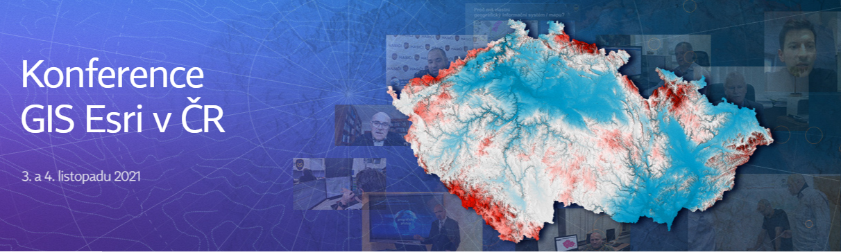
Přihláška na Konferenci GIS Esri v ČR byla právě spuštěna. Přečtěte si podrobnosti a pokud máte navíc i nějaký zajímavý projekt, určitě neváhejte a využijte jednu z možností prezentace. Jaká letošní konference bude a kdo se může přihlásit? Vzhledem k okolnostem jsme se rozhodli konferenci uspořádat opět virtuální formou, což Vám mimo jiné zajistí, že […]
The post Konferenci GIS Esri v ČR (přihlašování) appeared first on GISportal.cz.
Konferenci GIS Esri v ČR (přihlašování)
9.9.2021 8:17 GISportal.czPřihláška na Konferenci GIS Esri v ČR byla právě spuštěna. Přečtěte si podrobnosti a pokud máte navíc i nějaký zajímavý projekt, určitě neváhejte a využijte jednu z možností prezentace. Jaká letošní konference bude a kdo se může přihlásit? Vzhledem k okolnostem jsme se rozhodli konferenci uspořádat opět virtuální formou, což Vám mimo jiné zajistí, že […]
The post Konferenci GIS Esri v ČR (přihlašování) appeared first on GISportal.cz.
Pynwheel Unveils 3D Maps for Interactive Property Map Solution
9.9.2021 0:53 GISCafe.com Webcasts-Webinars New Feature to Further Enhance Multifamily Property Websites with Pynwheel MapsDENVER, Sept. 8, 2021 — (PRNewswire) —
…
Agrowing and Senseacre Labs partner for enhancing aerial remote sensing from NDVI to Deep Learning AI Precision Agriculture" solutions in India
9.9.2021 0:53 GISCafe.com Webcasts-Webinars Senseacre Labs of India Agrowing of Israel enter a collaboration to enhance aerial precision agriculture in India with the next level of deep …CoreLogic Estimates $16 Billion to $24 Billion in Insured and Uninsured Flood Losses in the Northeast from Tropical Storm Ida
8.9.2021 21:59 GISCafe.com Webcasts-Webinars —One of the worst flooding events in this region underscores importance for community resilience ahead of increasingly severe natural …Nové číslo Zpravodaje ČKS 3/2021
8.9.2021 21:54 Česká kartografická společnost Přinášíme letošní třetí Zpravodaj České kartografické společnosti. Prolistovat si jej můžete online. Účastníci 24. kartografické konference v Ostravě si navíc u registrace mohou vyzvednout tištěnou verzi. Přejeme příjemné čtení!Airspace Link Announces Partnership with the City of Las Vegas to Enable Safer Drone Operations and Laying the Groundwork for Scalable Commercial Applications
8.9.2021 20:58 GISCafe.com Webcasts-Webinars DETROIT, Sept. 8, 2021 — (PRNewswire) — Airspace Link, Inc., a leading provider of drone mapping and solution software, announced it …20210908 - Změny VFK v nové verzi ISKN 9.2
8.9.2021 18:13 ČÚZK - předpisy a opatření V souvislosti s instalací nové verze ISKN 9.2 dojde ke změně ve struktuře výměnného formátu ISKN. Nová verze ponese označení 5.6. Předpokládaný termín instalace je 5.11.202120210908 - Změny VFK v nové verzi ISKN 9.2
8.9.2021 18:13 ČÚZK - Výměnný formát ISKN V souvislosti s instalací nové verze ISKN 9.2 dojde ke změně ve struktuře výměnného formátu ISKN. Nová verze ponese označení 5.6. Předpokládaný termín instalace je 5.11.202120210908 - Změny VFK v nové verzi ISKN 9.2
8.9.2021 18:13 ČÚZK - Výměnný formát ISKN V souvislosti s instalací nové verze ISKN 9.2 dojde ke změně ve struktuře výměnného formátu ISKN. Nová verze ponese označení 5.6. Předpokládaný termín instalace je 5.11.202120210908 - Změny VFK v nové verzi ISKN 9.2
8.9.2021 18:13 ČÚZK - Výměnný formát ISKN V souvislosti s instalací nové verze ISKN 9.2 dojde ke změně ve struktuře výměnného formátu ISKN. Nová verze ponese označení 5.6. Předpokládaný termín instalace je 5.11.202120210908 - Změny VFK v nové verzi ISKN 9.2
8.9.2021 18:13 ČÚZK - Výměnný formát ISKN V souvislosti s instalací nové verze ISKN 9.2 dojde ke změně ve struktuře výměnného formátu ISKN. Nová verze ponese označení 5.6. Předpokládaný termín instalace je 5.11.202120210908 - Změny VFK v nové verzi ISKN 9.2
8.9.2021 18:13 ČÚZK - Výměnný formát ISKN V souvislosti s instalací nové verze ISKN 9.2 dojde ke změně ve struktuře výměnného formátu ISKN. Nová verze ponese označení 5.6. Předpokládaný termín instalace je 5.11.202120210908 - Změny VFK v nové verzi ISKN 9.2
8.9.2021 17:53 ČÚZK /Katastr-nemovitosti/Poskytovani-udaju-z-KN/Vymenny-format-KN/Podrobne-informace-VF-ISKN/Archiv-podrobnych-informaci/20210908-Zmeny-VFK-v-nove-verzi-ISKN-9-220210908 - Změny VFK v nové verzi ISKN 9.2
8.9.2021 17:53 ČÚZK - předpisy a opatření Český úřad zeměměřický a katastrální zveřejnil novou aktualitu: V souvislosti s instalací nové verze ISKN 9.2 dojde ke změně ve struktuře výměnného formátu ISKN. Nová verze ponese označení 5.6. Předpokládaný termín instalace je 5.11.2021Fortem Technologies and URSA Announce Webinar: Defeating the Most Dangerous Drones
8.9.2021 17:44 GISCafe.com Webcasts-Webinars Pleasant Grove, Utah, Sept. 07, 2021 (GLOBE NEWSWIRE) -- Fortem Technologies, the leader in airspace security and defense for detecting and …NOAA Awards Tetra Tech $49 Million Coastal Geospatial Contract
8.9.2021 17:44 GISCafe.com Webcasts-Webinars PASADENA, Calif. — (BUSINESS WIRE) — September 8, 2021 —Tetra Tech, Inc. (NASDAQ: TTEK), a leading provider of high-end …
Inmarsat’s Velaris Connectivity Solution to Unlock Unlimited Possibilities of Fast-growing UAV Industry
8.9.2021 17:44 GISCafe.com Webcasts-Webinars LONDON — (BUSINESS WIRE) — September 8, 2021 —Ground-breaking new offering will safely integrate drones into managed airspace, …
Cupix Integration with Procore Delivers Industry’s First Location-Based Virtual Job Site Navigation
8.9.2021 17:44 GISCafe.com Webcasts-Webinars Integration with CupixWorks 3D Digital Twin Platform Works Seamlessly within the Procore Platform with No Additional Training RequiredSAN JOSE, …
VR do 26.10. rada/odborný rada – opravy chyb v KN
8.9.2021 16:54 ČÚZK - předpisy a opatření Katastrální úřad pro hlavní město Prahu - Katastrální pracoviště Praha VR do 1.10. rada/odborný rada – opravy chyb v KN Ředitelka úřadu vyhlašuje výběrové řízení na systemizované služební místo:rada/odborný rada – opravy chyb
VR do 19.11. referent KN – zápis do protokolu řízení V a Z
8.9.2021 16:54 ČÚZK /Urady/Katastralni-urady/Katastralni-urady/Katastralni-urad-pro-hlavni-mesto-Prahu/O-uradu/Aktuality/VR-do-1-10-rada-odborny-rada-–-opravy-chyb-v-KNVR do 1.10. rada/odborný rada – opravy chyb v KN
8.9.2021 16:54 ČÚZK /Urady/Katastralni-urady/Katastralni-urady/Katastralni-urad-pro-hlavni-mesto-Prahu/O-uradu/Aktuality/VR-do-1-10-rada-odborny-rada-–-opravy-chyb-v-KNVR do 26.10. rada/odborný rada – opravy chyb v KN
8.9.2021 16:54 ČÚZK /Urady/Katastralni-urady/Katastralni-urady/Katastralni-urad-pro-hlavni-mesto-Prahu/O-uradu/Aktuality/VR-do-1-10-rada-odborny-rada-–-opravy-chyb-v-KNVR do 1.10. rada/odborný rada – opravy chyb v KN
8.9.2021 16:54 ČÚZK - předpisy a opatření Katastrální úřad pro hlavní město Prahu - Katastrální pracoviště Praha VR do 1.10. rada/odborný rada – opravy chyb v KN Ředitelka úřadu vyhlašuje výběrové řízení na systemizované služební místo:Rada/odborný rada – opravy chyb v KN
VR do 19.11. referent KN – zápis do protokolu řízení V a Z
8.9.2021 16:54 ČÚZK - předpisy a opatření Katastrální úřad pro hlavní město Prahu VR do 1.10. rada/odborný rada – opravy chyb v KN Ředitelka úřadu vyhlašuje výběrové řízení na systemizované služební místo:referent KN – zápis do protokolu řízení V a Z
VR do 29.9. vrchní referent/rada – kontrola listin určených k záznamu
8.9.2021 16:49 ČÚZK /Urady/Katastralni-urady/Katastralni-urady/Katastralni-urad-pro-hlavni-mesto-Prahu/O-uradu/Aktuality/VR-do-29-9-vrchni-referent-rada-–-kontrola-listinVR do 29.9. vrchní referent/rada – kontrola listin určených k záznamu
8.9.2021 16:49 ČÚZK - předpisy a opatření Katastrální úřad pro hlavní město Prahu - Katastrální pracoviště Praha VR do 29.9. VR na služební místo vrchní referent/rada – kontrola listin určených k záznamu Ředitelka úřadu vyhlašuje výběrové řízení na systemizované služební místo:Vrchní referent/rada – kontrola listin určených k záznamu
New angle on reflected satnav yields sharper sea tracking
8.9.2021 16:48 ESA Navigation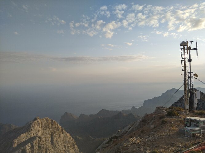
An experimental satellite navigation receiver station high atop Spain’s Mallorca island has opened up a novel view of the ever-changing face of the sea. By picking up satnav signals from the far horizon as they bounce off ocean waves, the receivers are able to measure sea surface height down to a scale of centimetres.
VR do 30.9. rada/odborný rada – vedoucí oddělení potvrzování geometrických plánů
8.9.2021 16:43 ČÚZK /Urady/Katastralni-urady/Katastralni-urady/Katastralni-urad-pro-hlavni-mesto-Prahu/O-uradu/Aktuality/VR-do-30-9-rada-odborny-rada-–-vedouci-oddeleni-pVR do 30.9. rada/odborný rada – vedoucí oddělení potvrzování geometrických plánů
8.9.2021 16:43 ČÚZK - předpisy a opatření Katastrální úřad pro hlavní město Prahu - Katastrální pracoviště Praha VR na služební místo rada/odborný rada – vedoucí oddělení potvrzování geometrických plánů Ředitelka úřadu vyhlašuje výběrové řízení na systemizované služební místo:Rada/odborný rada – vedoucí oddělení potvrzování geometrických plánů
rada/odborný rada – opravy chyb v KN
8.9.2021 16:33 ČÚZK - volná místa Katastrální úřad pro hlavní město Prahu Katastrální pracoviště Praha vypisuje výběrové řízení na místo rada/odborný rada – opravy chyb v KNrada/odborný rada – opravy chyb v KN
8.9.2021 16:33 ČÚZK - předpisy a opatření Katastrální úřad pro hlavní město Prahu Katastrální pracoviště Prahavypisuje výběrové řízení na místo
rada/odborný rada – opravy chyb v KN
vrchní referent/rada – kontrola listin určených k záznamu
8.9.2021 16:28 ČÚZK - předpisy a opatření Katastrální úřad pro hlavní město Prahu Katastrální pracoviště Prahavypisuje výběrové řízení na místo
vrchní referent/rada – kontrola listin určených k záznamu