


![]()

zprávy
zdroje zpráv:Odborný referent / vrchní referent – správa dokumentace katastru v oddělení aktualizace a dokumentac
23.9.2021 14:16 ČÚZK - předpisy a opatření Katastrální úřad pro Zlínský kraj Katastrální pracoviště Valašské Kloboukyvypisuje výběrové řízení na místo
Odborný referent / vrchní referent – správa dokumentace katastru v oddělení aktualizace a dokumentace KN Katastrálního pracoviště Valašské Klobouky
Odborný referent / vrchní referent – správa dokumentace katastru v oddělení aktualizace a dokumentac
23.9.2021 14:16 ČÚZK /Urady/Katastralni-urady/Katastralni-urady/Katastralni-urad-pro-Zlinsky-kraj/Uredni-deska/Oznameni-a-jina-uredni-sdeleni/Volna-mista/DMS/Odborny-referent-vrchni-referent-–-sprava-dokumeProgram konference Geomatika 2021
23.9.2021 12:24 ZeměměřičNa začátku října pořádá Asociace podnikatelů v geomatice svoji valnou hromadu. Po valné hromadě, určené pouze členům, se můžete zúčastnit konference, nazvané Geomatika 2021. 14:00 – 14:20 – Zahájení: Ing. Martin Hrdlička (APG) 14:20 – 14:40 – DTM a samospráva: Ing. Martin Kupka (PS PČR) 14:40 – 15:00 – Hlavní principy zakotvené v právních předpisech DMVS: Ing. Karel Štencel (ČÚZK) […]
The post Program konference Geomatika 2021 appeared first on Zeměměřič.
Zákonná komora zeměměřičů v programu konference Geomatika 21
23.9.2021 12:24 ZeměměřičNa začátku října pořádá Asociace podnikatelů v geomatice svoji valnou hromadu. Po valné hromadě, určené pouze členům, se můžete zúčastnit konference, nazvané Geomatika 21. 14:00 – 14:20 – Zahájení: Ing. Martin Hrdlička (APG) 14:20 – 14:40 – DTM a samospráva: Ing. Martin Kupka (PS PČR) 14:40 – 15:00 – Hlavní principy zakotvené v právních předpisech DMVS: Ing. Karel Štencel (ČÚZK) […]
The post Zákonná komora zeměměřičů v programu konference Geomatika 21 appeared first on Zeměměřič.
Webinář - 3D mapování podzemních prostor: od skenování po finální produkt
23.9.2021 12:20 3gon Záznam z webináře Mapování podzemních prostor pomocí 3D skenování (statického a mobilního) - klikni.Ukážeme si jak jednoduše lze skenovat a následně jak udělat požadovaný výstup a to například 3D model, objem, profily a řezy atd. Když se ví jak na to, nic není nemožné a obtížné. My to víme :) Budeme si hrát se skenery GeoSLAM atd. a zpracovávat data v softwarech GeoSLAM HUB a Carlson Point Cloud od společnosti Carlson Software, Inc., kde vytvoříme prostorový model podzemí s jeho následnou editací, výpočtem objemů, vytvářením profilů a příčných řezů a bude zodpovězena problematika, jak vytvořená data využít v dalších profesích a návazných softwarových aplikacích.
Vybrané otázky věcných práv budou jedním z témat 26. semináře Katastr nemovitostí
23.9.2021 12:11 ZeměměřičSpolek zeměměřičů Brno zve na svůj 26. seminář o katastru nemovitostí. Akce se uskuteční 14. října 2021 v Třebíči v hotelu Atom. 8:00 – 9:00 Prezence účastníků 9:00 – 14:00 Seminář a diskuse Přednášející Mgr. Michal Králík, Ph.D. (Nejvyšší soud České republiky): Vybrané otázky věcných práv v občanském zákoníku z pohledu aktuální judikatury Nejvyššího soudu ČR Ing. Bc. Vladimíra Žufanová, Ph.D. (Český […]
The post Vybrané otázky věcných práv budou jedním z témat 26. semináře Katastr nemovitostí appeared first on Zeměměřič.
Vybrané otázky věcných práv jedním z témat 26. semináře Katastr nemovitostí
23.9.2021 12:11 ZeměměřičSpolek zeměměřičů Brno zve na svůj 26. seminář o katastru nemovitostí. Akce se uskuteční 14. října 2021 v Třebíči v hotelu Atom. 8:00 – 9:00 Prezence účastníků 9:00 – 14:00 Seminář a diskuse Přednášející Mgr. Michal Králík, Ph.D. (Nejvyšší soud České republiky): Vybrané otázky věcných práv v občanském zákoníku z pohledu aktuální judikatury Nejvyššího soudu ČR Ing. Bc. Vladimíra Žufanová, Ph.D. (Český […]
The post Vybrané otázky věcných práv jedním z témat 26. semináře Katastr nemovitostí appeared first on Zeměměřič.
Odborný referent v oddělení právních vztahů k nemovitostem Katastrálního pracoviště Rychnov nad Kněž
23.9.2021 9:22 ČÚZK - předpisy a opatření Katastrální úřad pro Královéhradecký kraj - Katastrální pracoviště Rychnov nad Kněžnouvypisuje výběrové řízení na místo
Odborný referent v oddělení právních vztahů k nemovitostem Katastrálního pracoviště Rychnov nad Kněžnou
Odborný referent v oddělení právních vztahů k nemovitostem Katastrálního pracoviště Rychnov nad Kněž
23.9.2021 9:22 ČÚZK - volná místa Katastrální úřad pro Královéhradecký kraj - Katastrální pracoviště Rychnov nad Kněžnou vypisuje výběrové řízení na místo Odborný referent v oddělení právních vztahů k nemovitostem Katastrálního pracoviště Rychnov nad KněžOdborný referent v oddělení právních vztahů k nemovitostem Katastrálního pracoviště Rychnov nad Kněž
23.9.2021 9:22 ČÚZK /Urady/Katastralni-urady/Katastralni-urady/Katastralni-urad-pro-Kralovehradecky-kraj/Volna-mista/Odborny-referent-v-oddeleni-pravnich-vztahu-k-nemoGeodet/ka
23.9.2021 8:21 ČÚZK /Urady/Zememericky-urad/Uredni-deska/Oznameni-a-jina-uredni-sdeleni/Volna-mista/Geodet-ka-(1)Geodet/ka
23.9.2021 8:21 ČÚZK - volná místa Zeměměřický úřad vypisuje výběrové řízení na místo Geodet/kaGeodet/ka
23.9.2021 8:21 ČÚZK - předpisy a opatření Zeměměřický úřadvypisuje výběrové řízení na místo
Geodet/ka
Geodet/ka
23.9.2021 8:21 Zeměměřický úřad Zeměměřický úřadvypisuje výběrové řízení na místo
Geodet/ka
FEMA Awards Geospark Analytics New Contract for Community Lifeline Interdependency Analysis
22.9.2021 23:33 GISCafe.com Webcasts-Webinars HERNDON, Va., Sept. 22, 2021 — (PRNewswire) — Geospark Analytics, a world class leader in applied artificial intelligence …Seminář Katastr nemovitostí XXVI., 2021
22.9.2021 21:43 Spolek zeměměřičů Brno Dne 14. října 2021 se uskutečnil seminář o katastru nemovitostí.Kde: Hotel Atom, Velkomeziříčská 640/45, Třebíč Program 8:00 – 9:00 Prezence účastníků9:00 – 14:00 Seminář a diskuse Přednášející Mgr. Michal Králík, Ph.D. (Nejvyšší soud České republiky)Vybrané otázky věcných práv v občanském zákoníku z pohledu aktuální judikatury Nejvyššího soudu ČR Ing. Bc. Vladimíra... Read more »Seminář Katastr nemovitostí XXVI., 2021
22.9.2021 21:43 Spolek zeměměřičů Brno Dne 14. října 2021 se uskuteční seminář o katastru nemovitostí.Kde: Hotel Atom, Velkomeziříčská 640/45, Třebíč Program 8:00 – 9:00 Prezence účastníků9:00 – 14:00 Seminář a diskuse Přednášející Mgr. Michal Králík, Ph.D. (Nejvyšší soud České republiky)Vybrané otázky věcných práv v občanském zákoníku z pohledu aktuální judikatury Nejvyššího soudu ČR Ing. Bc. Vladimíra... Read more »Vexcel Data Program Enhances Wide Area Capture Program in U.S. and Europe
22.9.2021 20:05 GISCafe.com Webcasts-Webinars BOULDER, Colo., Sept. 22, 2021 — (PRNewswire) — Vexcel Data Program announced today it will enhance its entire Wide Area …Data Science Helps Raleigh Water Avoid Digging Up The Streets
22.9.2021 18:21 GISCafe.com Webcasts-Webinars Xylem & Esri Partner to Analyze Risk on 88,000 Pipe Segments And Reduce Planning Time by 75%RYE BROOK, N.Y. — (BUSINESS WIRE) — …
Press Release - Enhanced User Experience with New Online Map Service
22.9.2021 16:28 GISCafe.com Webcasts-Webinars Enhanced User Experience with New Online Map ServiceCLERMONT-FERRAND, France – September 21, 2021 – PlanetObserver and Kalisio reveal …
Guidebook on Airport Response to UAS Threats, Developed by Woolpert, Published by National Safe Skies Alliance
22.9.2021 16:25 GISCafe.com Webcasts-Webinars The information is designed to help airports develop planning, response and recovery protocols.DENVER, Sept. 22, 2021 — (PRNewswire) — …
Draganfly Selected as Exclusive Manufacturer for Valqari Drone Delivery Stations and Receives Initial $400,000 Order
22.9.2021 16:23 GISCafe.com Webcasts-Webinars Los Angeles, CA., Sept. 22, 2021 (GLOBE NEWSWIRE) -- Draganfly Inc. (NASDAQ: DPRO) (CSE: DPRO) (FSE: 3U8) (“Draganfly” or the “Company”), …Matternet and SkyGo partner with Abu Dhabi DoH for world's first city-wide medical drone network
22.9.2021 16:23 GISCafe.com Webcasts-Webinars Advanced aerial delivery network positions the Emirate on the leading-edge of healthcare and last-mile logisticsABU DHABI, UAE, Sept. 22, 2021 …
20210922_Odborný referent oddělení právních vztahů k nemovitostem
22.9.2021 14:12 ČÚZK - předpisy a opatření Katastrální úřad pro Středočeský kraj - Katastrální pracoviště Kutná Hora Vyhlášení výběrového řízení: odborný referent oddělení právních vztahů k nemovitostem V části "Úřední deska", v sekci "Oznámení a jiná úřední sdělení" bylo vystaveno "Oznámení o vyhlášení výběrového řízení na obsazení služebního místa odborný referent oddělení právních vztahů k nemovitostem"20210922_Odborný referent oddělení právních vztahů k nemovitostem
22.9.2021 14:12 ČÚZK /Urady/Katastralni-urady/Katastralni-urady/Katastralni-urad-pro-Stredocesky-kraj/Katastralni-pracoviste/KP-Kutna-Hora/O-uradu/Aktuality/20210922_Odborny-referent-oddeleni-pravnich-vztahuOdborný referent oddělení právních vztahů k nemovitostem
22.9.2021 14:09 ČÚZK - volná místa Katastrální úřad pro Středočeský kraj - Katastrální pracoviště Kutná Hora vypisuje výběrové řízení na místo Odborný referent oddělení právních vztahů k nemovitostemOdborný referent oddělení právních vztahů k nemovitostem
22.9.2021 14:09 ČÚZK - předpisy a opatření Katastrální úřad pro Středočeský kraj - Katastrální pracoviště Kutná Horavypisuje výběrové řízení na místo Odborný referent oddělení právních vztahů k nemovitostem
Odborný referent oddělení právních vztahů k nemovitostem
20210922_Odborný referent oddělení aktualizace PI KN I.
22.9.2021 13:59 ČÚZK - předpisy a opatření Katastrální úřad pro Středočeský kraj - Katastrální pracoviště Praha-západ Vyhlášení výběrového řízení: odborný referent oddělení aktualizace PI KN I. V části "Úřední deska", v sekci "Oznámení a jiná úřední sdělení" bylo vystaveno "Oznámení o vyhlášení výběrového řízení na obsazení služebního místa odborný referent oddělení aktualizace PI KN I. "20210922_Odborný referent oddělení aktualizace PI KN I.
22.9.2021 13:59 ČÚZK /Urady/Katastralni-urady/Katastralni-urady/Katastralni-urad-pro-Stredocesky-kraj/Katastralni-pracoviste/KP-Praha-zapad/O-uradu/Aktuality/20210922_Odborny-referent-oddeleni-aktualizace-PIOdborný referent oddělení aktualizace PI KN I.
22.9.2021 13:55 ČÚZK - předpisy a opatření Katastrální úřad pro Středočeský kraj - Katastrální pracoviště Praha-západvypisuje výběrové řízení na místo odborný referent oddělení aktualizace PI KN I.
Odborný referent oddělení aktualizace PI KN I.
REFERENT MAJETKOVÉ SPRÁVY
22.9.2021 11:49 ČÚZK - volná místa Katastrální úřad pro hlavní město Prahu vypisuje výběrové řízení na místo REFERENT MAJETKOVÉ SPRÁVYreferent majetkové správy
22.9.2021 11:49 ČÚZK /Urady/Katastralni-urady/Katastralni-urady/Katastralni-urad-pro-hlavni-mesto-Prahu/Volna-mista/DMS/REFERENT-MAJETKOVE-SPRAVYreferent majetkové správy
22.9.2021 11:49 ČÚZK - volná místa Katastrální úřad pro hlavní město Prahu vypisuje výběrové řízení na místo referent majetkové správyreferent majetkové správy
22.9.2021 11:49 ČÚZK - předpisy a opatření Katastrální úřad pro hlavní město Prahuvypisuje výběrové řízení na místo
referent majetkové správy
New infrastructure in Kerguelen island, key for the continued Galileo Service Provision
22.9.2021 11:07 European GNSS Agency
The construction of a new Galileo Sensor Station in the Kerguelen Islands, in the French Southern and Antarctic Lands (TAAF), was recently completed. The installation of the infrastructure has now begun and will be followed by integration and testing of the GSS apparatuses, which will continue until May 2022 to ensure its robust functioning in view of the forthcoming Galileo satellites launches.
To make the best use of the Galileo services, users rely on much more than the satellites orbiting the earth at an altitude of 23.000km. Dedicated facilities such as the Galileo Control Centers (GCCs), the sensor and uplink stations are some of the most important components that make up the so-called ‘’Galileo Ground Segment’’ the role of which is to support the service provision of Europe’s own Global Navigation Satellite System.
The Galileo Sensor Stations (GSS) are a network of antennas deployed at remote sites located around the world for real-time monitoring of the signal precision and quality, as well as establishing the satellite orbits with precision.
A new infrastructure was recently built in the Kerguelen Islands to host the newest, state-of-the art GSS. The new station will replace the previous one, built in the earliest stages of the programme, as part of an update of the world-wide network of the Galileo Ground Segment. These upgrades will further increase the performance of the European navigation and positioning system and guarantee an accurate, precise signal at all times across the globe.

A remote EU location of significant importance.
Situated in the sub-Antarctic region of the Indian Ocean, with a population of about 150 scientists, researchers and soldiers, the Kerguelen Islands are among the world’s most isolated places, 3500 km away from the Reunion island. Under French jurisdiction, these volcanic islands are part of Europe.
"Placing the GSS in the Kerguelen islands is of major importance. Galileo is the EU’s largest and most ambitious industrial project - maintaining its integrity and performance is of utmost importance for Europe and its citizens. This is a perfect location for both operational and security reasons" says Executive Director, Rodrigo da Costa.
Putting together the infrastructure was not easy due to the weather conditions and the island’s remote location. It is reached only four times a year by “Marion Dufresne”, a vessel departing from La Réunion, and anchoring off the Kerguelen Islands only after 15 days of sailing. The new GSS worth 2 million euros is fully funded by the European Union and is set to undergo tests until May 2022 to ensure its robust functioning in view of the forthcoming Galileo satellites launches.
Media note: This feature can be republished without charge provided the European Union Agency for the Space Programme (EUSPA) is acknowledged as the source at the top or the bottom of the story. You must request permission before you use any of the photographs on the site. If you republish, we would be grateful if you could link back to the EUSPA website (http://www.euspa.europa.eu).
New infrastructure in Kerguelen Islands, key for the continued Galileo Service Provision
22.9.2021 11:07 European GNSS AgencyThe construction of a new Galileo Sensor Station in the Kerguelen Islands, in the French Southern and Antarctic Lands (TAAF), was recently completed. The installation of the infrastructure has now begun and will be followed by integration and testing of the GSS apparatuses, which will continue until May 2022 to ensure its robust functioning in view of the forthcoming Galileo satellites launches.
To make the best use of the Galileo services, users rely on much more than the satellites orbiting the Earth at an altitude of 23.000km. Dedicated facilities such as the Galileo Control Centers (GCCs), sensor and uplink stations are some of the most important components that make up the so-called ‘’Galileo Ground Segment’’ the role of which is to support the service provision of Europe’s own Global Navigation Satellite System.
The Galileo Sensor Stations (GSS) are a network of antennas deployed at remote sites located around the world for real-time monitoring of the signal precision and quality, as well as establishing the satellite orbits with precision.
A new infrastructure was recently built in the Kerguelen Islands to host the newest, state-of-the art GSS. The new station will replace the previous one, built in the earliest stages of the programme, as part of an update of the world-wide network of the Galileo Ground Segment. These upgrades will further increase the performance of the European navigation and positioning system and guarantee an accurate, precise signal at all times across the globe.
A remote EU location of significant importance.
Situated in the sub-Antarctic region of the Indian Ocean, with a population of about 150 scientists, researchers and soldiers, the Kerguelen Islands are among the world’s most isolated places, 3500 km away from the Reunion Island. Under French jurisdiction, these volcanic islands are part of Europe.
"Placing the GSS in the Kerguelen islands is of major importance. Galileo is the EU’s largest and most ambitious industrial project - maintaining its integrity and performance is of utmost importance for Europe and its citizens. This is a perfect location for both operational and security reasons" says Executive Director, Rodrigo da Costa.
Putting together the infrastructure was not easy due to the weather conditions and the island’s remote location. It is reached only four times a year by “Marion Dufresne”, a vessel departing from La Réunion, and anchoring off the Kerguelen Islands only after 15 days of sailing. The new GSS of 2 million euros worth is fully funded by the European Union and is set to undergo tests until May 2022 to ensure its robust functioning in view of the forthcoming Galileo satellites launches.
Media note: This feature can be republished without charge provided the European Union Agency for the Space Programme (EUSPA) is acknowledged as the source at the top or the bottom of the story. You must request permission before you use any of the photographs on the site. If you republish, we would be grateful if you could link back to the EUSPA website (http://www.euspa.europa.eu).
Pozvánka na Joint conference 2021
22.9.2021 10:55 Blogující geomatici - FAV ZČURádi bychom pozvali všechny zájemce a nadšence o geomatiku a geoprostorová data na letošní ročník JOINT CONFERENCE 2021. Ta v sobě zahrnuje 25. ročník konference Informačních systémů v zemědělství a lesnictví (ISAF), 14. ročník Geomatiky v projektech, 6. výroční konferenci asociace Plan4All a také konferenci Agriculture 4.0 smart farming and climate.
Pro letošní rok vzhledem ke stále nestálé celosvětové situaci zachovává konference virtuální formát. Hlavní dny konference se uskuteční virtuálně ve středu 20. října a ve čtvrtek 21. října 2021. Konference je pro registrované zdarma.
Registrace účastníků a konferenčních příspěvků je k dispozici jednotně na odkaze: https://forms.gle/UnVMM2dJHyREDpSXA.
Příspěvky mohou být libovolného konferenčním tématu a postačí pro jejich registraci abstrakt. Členové programového výboru mohou po konferenci oslovit autory vybraných příspěvků s možností publikace rozšířených verzí příspěvků v online časopisu Agris online.
Pozvánka na webinář ArcGIS v prostředí webu
22.9.2021 10:54 Blogující geomatici - FAV ZČUBěhem webináře se zaměříme na práci s nejpoužívanějšími aplikacemi ArcGIS:
ArcGIS Pro, ArcGIS Online, ArcGIS Field Maps, ArcGIS Survey123, ArcGIS Insights a ArcGIS StoryMaps.
V rámci jednotlivých ukázek přitom projdeme všechny důležité fáze práce v GIS, kterými jsou:
- sběr geodat,
- analýza geodat,
- tvorba interaktivní mapy,
- a prezentace výsledků pomocí webové aplikace obsahující interaktivní mapu spolu s dalšími informačními zdroji.
Povíme si i o správě uživatelů prostřednictvím portálu, díky kterému se všechny tyto procesy mohou odehrávat nad jediným úložištěm dat (na serveru nebo v cloudu). Každý uživatel tak data využívá:
- odkudkoli (tedy distančně),
- podle svých oprávnění (tedy bezpečně),
- z jakéhokoli zařízení (PC, mobil, tablet),
- z webu či prostřednictvím nainstalované aplikace.
Díky portálu je navíc možná spolupráce (sdílené využívání geodat) v rámci organizace i mezi organizacemi navzájem.
Forma webináře: online v Google meet (meet.google.com/wsd-vzom-dxy)
Termín webináře: 4. 10. 2021 v čase 11:10 – 13:40
Přednášející: Radek Kuttelwascher, ARCDATA PRAHA, s.r.o.
Úroveň webináře: Seminář je koncipován pro uživatele ArcGIS různé pokročilosti (pedagogy i studenty).
Dotazy v chatu či ústně předem i během webináře jsou vítány.
JOINT CONFERENCE 2021 (pozvánka)
22.9.2021 9:51 GISportal.cz
Rádi bychom pozvali všechny zájemce a nadšence o geomatiku a geoprostorová data na letošní ročník JOINT CONFERENCE 2021. Ta v sobě zahrnuje 25. ročník konference Informačních systémů v zemědělství a lesnictví (ISAF), 14. ročník Geomatiky v projektech, 6. výroční konferenci asociace Plan4All a také konferenci Agriculture 4.0 smart farming and climate. Pro letošní rok vzhledem ke stále […]
The post JOINT CONFERENCE 2021 (pozvánka) appeared first on GISportal.cz.
JOINT CONFERENCE 2021 (pozvánka)
22.9.2021 9:51 GISportal.czRádi bychom pozvali všechny zájemce a nadšence o geomatiku a geoprostorová data na letošní ročník JOINT CONFERENCE 2021. Ta v sobě zahrnuje 25. ročník konference Informačních systémů v zemědělství a lesnictví (ISAF), 14. ročník Geomatiky v projektech, 6. výroční konferenci asociace Plan4All a také konferenci Agriculture 4.0 smart farming and climate. Pro letošní rok vzhledem ke stále […]
The post JOINT CONFERENCE 2021 (pozvánka) appeared first on GISportal.cz.
Landsat 9 denně pořídí 700 záznamů Země. Rozšíří tak současných osm milionů družicových snímků z předchozích 50 let
22.9.2021 6:30 GeoBusinessAmerické družice Landsat již téměř padesát let snímkují Zemi. Vypuštěním družice Landsat 9 koncem září (27. září 2021) bude pokračovat nejdelší družicový záznam Země. Od vypuštění první družice Landsat v roce 1972 se archiv této mise rozrostl na více než 8 milionů snímků, které jsou veřejnosti volně přístupné. Landsat 9 bude obíhat kolem Země v intervalu 99 minut […]
The post Landsat 9 denně pořídí 700 záznamů Země. Rozšíří tak současných osm milionů družicových snímků z předchozích 50 let appeared first on GeoBusiness.
Hexagon aids Piaseczno, Poland’s public safety transformation
22.9.2021 4:00 Hexagon Safety & InfrastructurePředběžná tržní konzultace k nákupu hybridních vozidel (mild-hybrid)
22.9.2021 0:00 Státní pozemkový úřad Praha, 22. září 2021 - Státní pozemkový úřad (SPÚ) se jako zadavatel rozhodl využít institutu předběžné tržní konzultace (PTK) dle ust. § 33 zákona č. 134/2016 Sb., ve znění pozdějších předpisů, o zadávání veřejných zakázek, a zahájil dne 22. 9. 2021 PTK s cílem stanovit zadávací podmínky veřejné zakázky na dodávku hybridních osobních vozidel (mild-hybrid).Portál Církevní mapy – historické mapy českých zemí [Knihovna geografie, byTopic]
22.9.2021 0:00 Katedra aplikované geoinformatiky a kartografie Přf UK Všem zájemcům o historickou kartografii doporučujeme webový portál Církevní mapy, který si klade za cíl představit výsledky zpracování dat raně novověké církevní správy v českých zemích formou interaktivní webové mapy. Zájemci o církevní dějiny mají možnost v aplikaci porovnávat různé mapové podklady a procházet podrobné textové údaje o farní síti.Sanborn Wins Major Mapping Contract with USGS
21.9.2021 23:22 GISCafe.com Webcasts-Webinars Contract for Geospatial Services Spans Five YearsCOLORADO SPRINGS, Colo. — (BUSINESS WIRE) — September 21, 2021 —
The Sanborn Map …
Pay As You Go: Advanced Photogrammetry Now Available Without a Subscription
21.9.2021 23:22 GISCafe.com Webcasts-Webinars The professional choice for creating detailed 3D models from ordinary photos now has simple and transparent on-demand pricingWASHINGTON, Sept. 21, …
Hexagon | NovAtel GNSS SMART Antenna now the default receiver selection on Fendt machines in North America, Europe and the Middle East
21.9.2021 20:18 GISCafe.com Webcasts-Webinars Standard Fendt guidance packages now include NovAtel's SMART7.CALGARY, Alberta, Sept. 21, 2021 — (PRNewswire) —
CALGARY, Alberta, …
Velodyne Lidar Announces Multi-Year Supply Agreement with TOPODRONE
21.9.2021 17:30 GISCafe.com Webcasts-Webinars TOPODRONE Survey Solutions – Equipped with Velodyne’s Lidar Sensors – Tackle Challenging Applications Including Farms, Forests, …New Trimble DA2 Receiver Boosts Performance of Trimble Catalyst GNSS Positioning Service
21.9.2021 17:30 GISCafe.com Webcasts-Webinars Subscription-Based Positioning Solution with Trimble ProPoint GNSS Technology Delivers "Simply Precise" Mapping WorkflowsSUNNYVALE, Calif., Sept. …
Soaring Eagle Imaging and Skynetwest unite to launch Soaring Eagle Technologies
21.9.2021 17:30 GISCafe.com Webcasts-Webinars Two leading companies join forces to become a premier UAS tech-enabled inspections companyHOUSTON, Sept. 21, 2021 — (PRNewswire) — …
EarthOptics Raises $10.3 million in Series A Funding, Led by Leaps by Bayer, to Accelerate Carbon Mapping
21.9.2021 17:30 GISCafe.com Webcasts-Webinars Investment to help accelerate roll-out of soil mapping and machine learning technologies for most accurate soil carbon content and compaction …MARTA Selects Woolpert for $5M Geospatial Survey Contract to Support Design, Construction
21.9.2021 17:30 GISCafe.com Webcasts-Webinars The firm will provide services that include terrestrial lidar, photogrammetry, BIM, UAS and subsurface utility engineering.ATLANTA, Sept. 21, 2021 …
OmniSci to Showcase Power of Massively-Accelerated Geospatial Analytics at GEOINT 2021
21.9.2021 17:30 GISCafe.com Webcasts-Webinars Presentations and Training Sessions will Highlight New Uses for OmniSci Platform That Queries and Visualizes Billions of Rows of Data in …INTERGEO Live and Digital 2021 Opens
21.9.2021 16:17 GISCafe.com Webcasts-Webinars The international ‘Smarter-Makers’ event begins live in Hannover INTERGEO, the largest meeting place for the geospatial industry, …Korekční služba Trimble Catalyst má novou anténu DA2 a začíná podporovat iOS
21.9.2021 16:04 ZeměměřičTrimble Catalyst je softwarový GNSS přijímač a stejnojmenná polohovací služba, u které si můžete volit přesnost dle vaší aktuální potřeby při měření. Přesnost měření je dána výběrem předplatného korekčních služeb, přičemž předplatné si můžete zvolit i na měsíce, ve kterých budete sbírat data. K tomu si můžete volit libovolnou přesnost v každém měsíci dle typu práce nebo sezóny. K dispozici jsou pro […]
The post Korekční služba Trimble Catalyst má novou anténu DA2 a začíná podporovat iOS appeared first on Zeměměřič.
Vyhlášení výběrového řízení - rada/odborný rada – interní auditor - IA
21.9.2021 13:34 ČÚZK /Urady/Katastralni-urady/Katastralni-urady/Katastralni-urad-pro-Plzensky-kraj/O-uradu/Aktuality/Vyhlaseni-vyberoveho-rizeni-rada-odborny-rada-–Vyhlášení výběrového řízení - rada/odborný rada – interní auditor - IA
21.9.2021 13:34 ČÚZK - předpisy a opatření Katastrální úřad pro Plzeňský kraj - Katastrální pracoviště Plzeň-město zveřejnil novou aktualitu: Vyhlášení výběrového řízení na služební místo Rada/odborný rada – interní auditor - IA , Katastrální úřad pro Plzeňský krajKatastrální úřad pro Plzeňský kraj
Rada/odborný rada – interní auditor - IA , Katastrální úřad pro Plzeňský kraj
21.9.2021 13:14 ČÚZK - předpisy a opatření Katastrální úřad pro Plzeňský kraj kancelář ředitelevypisuje výběrové řízení na místo
Rada/odborný rada – interní auditor - IA , Katastrální úřad pro Plzeňský kraj
Rada/odborný rada – interní auditor - IA , Katastrální úřad pro Plzeňský kraj
21.9.2021 13:14 ČÚZK - volná místa Katastrální úřad pro Plzeňský kraj kancelář ředitele vypisuje výběrové řízení na místo Rada/odborný rada – interní auditor - IA , Katastrální úřad pro Plzeňský krajRada/odborný rada – interní auditor - IA , Katastrální úřad pro Plzeňský kraj
21.9.2021 13:14 ČÚZK /Urady/Katastralni-urady/Katastralni-urady/Katastralni-urad-pro-Plzensky-kraj/Uredni-deska/Oznameni-a-jina-uredni-sdeleni/Volna-mista/DMS/Rada-odborny-rada-–-interni-auditor-IA-,-KatastPředstavte svoji práci na Konferenci GIS Esri v ČR 2021
21.9.2021 10:55 ARCDATA
Listopadová konference GIS Esri se blíží a s ní i možnost představit svoji práci na největším setkání geoinformatiků v ČR. Pokud máte zajímavý projekt, který by někomu mohl zjednodušit práci nebo poskytnout inspiraci, určitě nám o sobě dejte vědět.
V letošním roce konference proběhne 3. a 4. listopadu virtuální formou. I když se tedy nebudeme moci setkat osobně, můžete – právě díky virtuálnímu formátu – oslovit mnohem širší publikum než obvykle. Prezentovat se navíc můžete několika různými způsoby:
- Předtočení video přednášky
- Účast v přehlídce map a online aplikací
- Obrázek či mapa v zahajovací prezentaci
Pokud se rozhodnete pro natočenípřednášky, může Vám pomoci tento jednoduchý návod, který je stejně jako vzor abstraktu k nalezení na webových stránkách akce. Termín pro přihlášení příspěvku je 30. září 2021.
Zpracování mračen bodů z DJI L1 pomocí softwaru Terrasolid
21.9.2021 6:43 GeoBusinessFinská firma Terrasolid je producentem stejnojmenného softwaru Terrasolid, používaného pro zpracování mračen bodů a snímků. Na tomto webináři se seznámíte s kroky zpracování mračen bodů z LiDARové kamery L1 od DJI: Import mračna bodů a řešení trajektorie Odstranění nadbytečných dat Vyhlazování mračna bodů Klasifikace „zásahů“ do země Klasifikace „zásahů“ stromů, vegetace a střech budov Přizpůsobení nadmořské výšky dat kontrolním bodům […]
The post Zpracování mračen bodů z DJI L1 pomocí softwaru Terrasolid appeared first on GeoBusiness.
Bentley Systems Announces Finalists for the 2021 Going Digital Awards in Infrastructure
21.9.2021 3:27 GISCafe.com Webcasts-Webinars Finalists Also Announced for the Student Future Infrastructure Star ChallengeEXTON, Pa. — (BUSINESS WIRE) — September 20, 2021 …
Bentley Systems Announces Finalists for the 2021 Going Digital Awards in Infrastructure
20.9.2021 22:04 Bentley SystemsPress Announcements
Crunchy Data Delivers Trusted PostgreSQL Containers In Collaboration With The U.S. Department Of Defense
20.9.2021 21:40 GISCafe.com Webcasts-Webinars Crunchy PostgreSQL containers for Kubernetes have been approved for inclusion in Iron Bank, the DoD centralized repository for top development tools …AGM Selects Velodyne Lidar’s Alpha Prime Sensor for New Mobile Scanning System
20.9.2021 15:26 GISCafe.com Webcasts-Webinars AGM Provides Accurate and Powerful Mobile Mapping for Complex Applications Including Infrastructure, Smart City, MoreSAN JOSE, Calif. — …
On the Roof of Ecuador, XAG Spearheads Drones for Sustainable Andean Farming
20.9.2021 15:26 GISCafe.com Webcasts-Webinars QUITO, Ecuador, Sept. 20, 2021 — (PRNewswire) — Flying into the Andes mountains of Ecuador, XAG Agricultural Drones were recently …Pondělí, 20. 9. omezení výpůjční doby [Knihovna geografie, byTopic]
20.9.2021 13:30 Katedra aplikované geoinformatiky a kartografie Přf UK3D ve vzduchu i na zemi – pozvánka
20.9.2021 12:36 GeoBusinessSpolečnost 3GON Positioning všechny srdečně zve na akci, nazvanou 3D ve vzduchu i na zemi. Akce se uskuteční dvakrát, v Praze a Brně. října 2021 – Praha – Hotel Chvalská Tvrz, Na Chvalské tvrzi 858/11 října 2021 – Brno – Hotel Avanti, Střední 61 Program 09:30 – Registrace 10:00 – Představení techniky od DJI Enterprise 10:20 – DJI […]
The post 3D ve vzduchu i na zemi – pozvánka appeared first on GeoBusiness.
Gaudeamus Hejčín 2021
20.9.2021 11:55 Katedra geoinformatiky UP OlomoucBudoucí maturanti se začali již v září seznamovat se studijním oborem Geo informatika. Honza Roller prezentoval studium na Hejčínském gaudeámu v pátek 17. 9. 2021. Chcete taky propagovat geoinformatiku na své střední škole? Kontaktujte jakub.konicek@upol.cz
The post Gaudeamus Hejčín 2021 appeared first on Katedra geoinformatiky.
5 ways the EU Space Programme makes urban mobility more sustainable
20.9.2021 11:53 European GNSS Agency
The 20th EUROPEAN MOBILITY WEEK is on! This year’s motto is ‘Safe and Healthy with Sustainable Mobility’ paying tribute to the hardships felt by Europe – and the world – throughout the COVID-19 pandemic. Space is a significant booster in the development of new, intelligent mobility solutions as well as the monitoring of important urban infrastructures.
The European Mobility Week is the European Commission’s flagship awareness-raising campaign on sustainable urban mobility, promoting new ways of living in favour of active mobility, public transport, and other clean, intelligent transport solutions. The benefits of space services and data for sustainability and smart mobility are currently under the spotlight as the Union is investing more on its EU Space Programme for the definition of its green and digital policies. Here are 5 ways the EU Space Programme is positively impacting sustainable mobility:
1. Streamlining urban traffic
Transport is one of the main sources of air pollution, which is known to have direct effect on mortality as well as respiratory and cardiovascular diseases. The use of satellite navigation systems such as Galileo in vehicles can reduce journey times by more than 10%, and thus contribute to reducing emissions of harmful and polluting substances. Copernicus services can support emissions monitoring by validating the measurements from existing sensors and providing data from areas not covered otherwise.
2. Contributing to Intelligent Transport Systems (ITS)
ITS systems rely on positioning data, which has now become much more precise thanks to Galileo services. With the help of the EU’s GNSS, advanced implementation of Intelligent Transport System (ITS) is now becoming a reality for transport and mobility companies. The city of Madrid was among the first to integrate Galileo’s enhanced positioning services into its Transport System to improve public transport services in the Spanish capital. EU Space technology is becoming fundamental for the development of smart mobility solutions targeting the EU Green Deal.
3. Mobility infrastructure monitoring
Copernicus offers a broad range of products and services based on satellite optical data. Lidar images, can for instance, help urban planning authorities to identify changes in the terrain such as land subsidence or vegetation that could encroach rail tracks or power grids supplying the city with electricity. The combination of imagery from Copernicus with the very accurate positioning provided by Galileo allows for the monitoring of critical infrastructures tunnels, motorways and bridges.
4. Easing the flow of goods between EU cities during COVID-19
Developed by EUSPA in collaboration with the European Commission, the Galileo Green Lane app is a key tool in the EU’s COVID-19 pandemic response. By easing traffic flow through the EU’s borders, the app is helping to support a fundamental EU principle - the free movement of goods and freight in the internal market.
5. Faster emergency response on the road
As of April 2018, all new car models in the European Union are equipped with eCall technology. In the event of a serious accident, eCall automatically dials 112 - Europe's single emergency number - to provide faster assistance. Leveraging Galileo, the system sends the accurate position of the crashed vehicle and the direction of travel to the emergency services, enabling the emergency responders to get to the accident site faster. By speeding up emergency response times by 40% in urban areas and 50% in the countryside, it is estimated that eCall could help prevent 2,500 road deaths and save EUR 26 billion every year.
Towns and cities worldwide are invited to participate in the EUROPEANMOBILITYWEEK, which takes place 16-22 September each year, check out the interactive map to see if your city is taking part.
More info and registration here
Media note: This feature can be republished without charge provided the European Union Agency for the Space Programme (EUSPA) is acknowledged as the source at the top or the bottom of the story. You must request permission before you use any of the photographs on the site. If you republish, we would be grateful if you could link back to the EUSPA website (http://www.euspa.europa.eu).
Müllerova mapa Čech v 10 přednáškách odborníků
20.9.2021 11:24 GeoBusinessKatedra geomatiky Stavební fakulty ČVUT v Praze nahrála deset přednášek konference k 300. výročí Müllerovy mapy Čech. Eva Semotanová – Jan Kryštof Müller a evropská kartografie Jiří Martínek – Život Jana Kryštofa Müllera Jiří Hrbek – Společnost v době Jana Kryštofa Müllera Tomáš Janata – Müllerova mapa Království českého z pohledu kartografa Močičková/Vokurka – Nově objevený rukopisný rejstřík k Müllerově mapě Jiří […]
The post Müllerova mapa Čech v 10 přednáškách odborníků appeared first on GeoBusiness.
Vectorworks uvádí na trh verzi 2022 svých softwarů pro BIM a CAD
20.9.2021 10:49 BIM NewsSpolečnost Vectorworks vydává novou produktovou řadu Vectorworks 2022 s důrazem na technologické postupy nové generace, pracovní postupy 3D a BIM, součinnost, krajinotvorbu a pracovní postupy GIS a zábavního designu. Vectorworks svou produktovou řadu přejmenovala, aby přesněji reflektovala navrhování s pomocí BIM. Vectorworks Design Suite, dříve známá pod názvem Vectorworks Designer, však i nabízí všechny aktuální […]
The post Vectorworks uvádí na trh verzi 2022 svých softwarů pro BIM a CAD appeared first on BIM News.
Georadar Stream T změří anomálie v tunelech rychlostí až 60 km/hod
20.9.2021 10:40 ZeměměřičGeoradar Stream T, který představila firma IDS, měří anomálie v tunelech, jako je tloušťka ostění, vyztužené konstrukce, dutiny a vlhké oblasti. Modulární konstrukce systému Stream T umožňuje této inovativní georadarové soustavě překonávat překážky a pětinásobně zvýšit produktivitu ve srovnání s tradičními systémy a sbírat data rychlostí až 60 km/hod. Ovládání systému Stream T z interiéru vozidla zvyšuje bezpečnost techniků na místě […]
The post Georadar Stream T změří anomálie v tunelech rychlostí až 60 km/hod appeared first on Zeměměřič.
Robotické autonomní skenování s novým Leica BLK ARC
20.9.2021 10:29 ZeměměřičLeica Geosystems představila BLK ARC, svůj autonomní laserový skenovací modul pro roboty. Je určen k integraci s robotickými nosiči, aby umožnil autonomní mobilní laserové skenování s minimálním nebo žádným zásahem člověka. Uživatelé pouze nastaví trasu skenování. Pvním robotickým nosičem je robot Spot od Boston Dynamics. BLK ARC ve spojení se Spotem vytváří rychlý, jednoduchý, bezpečný a autonomní pracovní postup […]
The post Robotické autonomní skenování s novým Leica BLK ARC appeared first on Zeměměřič.
Odborný rada - metodik legislativy v oddělení metodiky, kontroly a personalistiky kanceláře ředitele
20.9.2021 10:07 ČÚZK /Urady/Katastralni-urady/Katastralni-urady/Katastralni-urad-pro-Kralovehradecky-kraj/Uredni-deska/Oznameni-a-jina-uredni-sdeleni/Volna-mista/Odborny-rada-metodik-legislativy-v-oddeleni-metoOdborný rada - metodik legislativy v oddělení metodiky, kontroly a personalistiky kanceláře ředitele
20.9.2021 10:07 ČÚZK - volná místa Katastrální úřad pro Královéhradecký kraj vypisuje výběrové řízení na místo Odborný rada - metodik legislativy v oddělení metodiky, kontroly a personalistiky kanceláře řediteleOdborný rada - metodik legislativy v oddělení metodiky, kontroly a personalistiky kanceláře ředitele
20.9.2021 10:07 ČÚZK - předpisy a opatření Katastrální úřad pro Královéhradecký krajvypisuje výběrové řízení na místo
Odborný rada - metodik legislativy v oddělení metodiky, kontroly a personalistiky kanceláře ředitele Katastrálního úřadu pro Královéhradecký kraj
Byl publikován Drone Industry Barometer 2021, kterého byla Aliance partnerem
20.9.2021 10:00 UAVATento týden byl publikován největší světový průzkum Drone Industry Barometer 2021 od Drone Industry Insights, kterého byla Aliance opět partnerem a který je k dispozici ke stažení zdarma. Tohoto rozsáhlého průzkumu se zúčastnilo téměř 700 firem z 64 států světa a přináší aktuální výsledky z drone industry. Ke stažení zdarma zde: https://droneii.com/project/drone-industry-barometer
The post Byl publikován Drone Industry Barometer 2021, kterého byla Aliance partnerem appeared first on UAV Aliance pro bezpilotní letecký průmysl.
Joining forces for Aeolus
20.9.2021 9:00 ESA Observing the Earth
For a team of scientists and technicians from Europe and the US, the fact of ‘going back to the office’ this September has meant heading off to the Cabo Verde islands in the Atlantic – not to extend their summer holidays, but for a complex international experiment campaign that will scrutinise the data being delivered by one of today’s most innovative Earth observation satellites: ESA’s Aeolus wind mission.
Kartografická výročí 2020/2021 – 300 let Müllerovy mapy Čech
20.9.2021 8:00 GISportal.cz
Seminář pod názvem Kartografická výročí 2020/2021 – 300 let Müllerovy mapy Čech formou ozvučených prezentací, které je možné shlédnout od 15. září 2021. Hlavními pořadateli jsou Česká kartografická společnost ve spolupráci s Historickým ústavem AV ČR, Katedrou geomatiky ČVUT Fakulty stavební a dalšími institucemi (Filosofická fakulta UJEP a Česká geografická společnost). Jan Kryštof Müller (Johann Christoph […]
The post Kartografická výročí 2020/2021 – 300 let Müllerovy mapy Čech appeared first on GISportal.cz.
Kartografická výročí 2020/2021 – 300 let Müllerovy mapy Čech
20.9.2021 8:00 GISportal.czSeminář pod názvem Kartografická výročí 2020/2021 – 300 let Müllerovy mapy Čech formou ozvučených prezentací, které je možné shlédnout od 15. září 2021. Hlavními pořadateli jsou Česká kartografická společnost ve spolupráci s Historickým ústavem AV ČR, Katedrou geomatiky ČVUT Fakulty stavební a dalšími institucemi (Filosofická fakulta UJEP a Česká geografická společnost). Jan Kryštof Müller (Johann Christoph […]
The post Kartografická výročí 2020/2021 – 300 let Müllerovy mapy Čech appeared first on GISportal.cz.
"Tecta America Zero Company Uses Nearmap to Add Value to Roofing Projects" by Susan Smith
18.9.2021 10:52 GISCafe.com Webcasts-WebinarsWoolpert Selected by USGS for Geospatial Products and Services Contract 4
18.9.2021 0:45 GISCafe.com Webcasts-Webinars The shared capacity contract will support federal, state and municipal government needs across the U.S.DAYTON, Ohio, Sept. 17, 2021 — …
Announcing HxGN Live GeoSummit, the flagship digital event of Hexagon's Geosystems division. Towards Autonomous Solutions and Digital Realities — Innovating for the Future.
17.9.2021 18:49 GISCafe.com Webcasts-Webinars (Heerbrugg, Switzerland, 16 September 2021) Hexagon, a global leader in digital reality solutions, is hosting a three-day virtual event, HxGN Live …Hexagon to showcase groundbreaking autonomous solutions and smart digital realities at INTERGEO 2021 Live+Digital
17.9.2021 18:43 GISCafe.com Webcasts-Webinars (Heerbrugg, Switzerland, 16 September 2021) Hexagon, a global leader in digital reality solutions, announces sponsoring and exhibiting at INTERGEO …Nová verze CAD Symbols pro Váš CAD 30 miliónů symbolů
17.9.2021 17:40 ŠPINAR - softwareVážení zákazníci,
dovolujeme si Vám nabídnout program CAD Symbols v 15 s ohromnou databází přes 30 milionů CAD symbolů ve 2D a 3D, které jednoduše vyhledáte a vložíte do svého CAD programu
The post Nová verze CAD Symbols pro Váš CAD 30 miliónů symbolů appeared first on ŠPINAR – software.
Nová verze CAD Symbols – 30 miliónů symbolů
17.9.2021 17:40 ŠPINAR - softwareVážení zákazníci,
dovolujeme si Vám nabídnout program CAD Symbols v 15 s ohromnou databází přes 30 milionů CAD symbolů ve 2D a 3D, které jednoduše vyhledáte a vložíte do svého CAD programu
The post Nová verze CAD Symbols – 30 miliónů symbolů appeared first on ŠPINAR – software.
USSOCOM to Receive Robotican Indoor Unmanned Reconnaissance Drone Systems
17.9.2021 17:36 GISCafe.com Webcasts-Webinars OMER, Israel, Sept. 17, 2021 — (PRNewswire) — Robotican has successfully delivered its first indoor UAS to the USSOCOM for operational …DISCOVER MORE INSPIRATIONS | GEOSPATIAL WORLD FORUM 2021
17.9.2021 11:59 Satlab GeosolutionsDISCOVER MORE INSPIRATIONS | GEOSPATIAL WORLD FORUM 2021 Event: Geospatial World Forum 2021 | SatLab New Product Launch Date: 20 – 22 October 2021 Geospatial World Forum 2021 is back! From 20th-22nd, October, the mega geospatial business and technical event is to re-connect the supply and demand of geospatial abilities in Amsterdam, the Netherlands. Under the theme […]
The post DISCOVER MORE INSPIRATIONS | GEOSPATIAL WORLD FORUM 2021 appeared first on SatLab – Global Satellite Positioning Solutions.
Nová verzia Trimble Access 2020.20
17.9.2021 10:19 Geotronics.sk Tento týždeň vyšla nová verzia softvéru Trimble Access pre kontrolné jednotky Trimble TSC7 s OS Windows 10, TDC600 a TCU5 s OS Android. Podrobný popis nových funkcií a opráv chýb starého softvéru nájdete TU: Zmena veľkosti mapy a formulára Teraz môžete pomocou jednoduchého ovládacieho prvku jazdca zmeniť veľkosť ľubovoľného formulára, ktorý sa zobrazí [...]Nová verzia Trimble Access 2020.20
17.9.2021 10:19 Geotronics.sk Tento týždeň vyšla nová verzia softvéru Trimble Access pre kontrolné jednotky Trimble TSC7 s OS Windows 10, TDC600 a TCU5 s OS Android. Podrobný popis nových funkcií a opráv chýb starého softvéru nájdete TU: Zmena veľkosti mapy a formulára Teraz môžete pomocou jednoduchého ovládacieho prvku jazdca zmeniť veľkosť ľubovoľného formulára, ktorý sa zobrazí [...]Leica BLK2FLY je nový autonomní létající laserový skener
17.9.2021 10:00 ZeměměřičFirma Leica Geosystems představila BLK2FLY, světově první plně integrovaný autonomní bezpilotní prostředek s LiDARem. Leica BLK2FLY je autonomní létající laserový skener s pokročilým vyhýbáním se překážkám pro snadné snímání reality z oblohy. Snímá exteriéry budov, stavby a prostředí a vytváří 3D mračna bodů za letu. BLK2FLY je navržen tak, aby se snadno používal: několika jednoduchými klepnutími na tabletu mohou uživatelé […]
The post Leica BLK2FLY je nový autonomní létající laserový skener appeared first on Zeměměřič.
Earth from Space: Maharloo Lake
17.9.2021 10:00 ESA Observing the Earth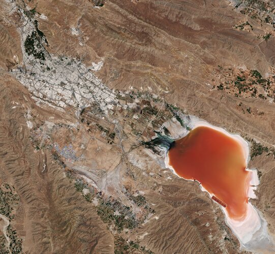
Maharloo Lake, a seasonal salt lake in Iran, is featured in this image captured by the Copernicus Sentinel-2 mission.
Kartograf/ka
17.9.2021 9:01 ČÚZK - volná místa Zeměměřický úřad vypisuje výběrové řízení na místo Kartograf/kaKartograf/ka
17.9.2021 9:01 ČÚZK /Urady/Zememericky-urad/Uredni-deska/Oznameni-a-jina-uredni-sdeleni/Volna-mista/Kartograf-ka-(1)Kartograf/ka
17.9.2021 9:01 Zeměměřický úřad Zeměměřický úřadvypisuje výběrové řízení na místo
Kartograf/ka
Kartograf/ka
17.9.2021 9:01 ČÚZK - předpisy a opatření Zeměměřický úřadvypisuje výběrové řízení na místo
Kartograf/ka
New Mapping Tool for Forest Carbon Hotspots and Biodiversity
17.9.2021 9:00 GISCafe.com Webcasts-Webinars Scientists Identify Forest Carbon “Hotspots” across US with Greatest Potential to Fight Climate Change and Protect SpeciesNew study and …
Bluesky and University of Leicester Use AI to Reduce Data Intensity for Smart City Applications
17.9.2021 9:00 GISCafe.com Webcasts-Webinars Leicestershire, UK, 13 September 2021 - Aerial mapping company Bluesky International and the University of Leicester are using Artificial …KVS Technologies signs US$60 million strategic agreement with US-based Spright to deliver linear infrastructure drone inspection services in North America
16.9.2021 16:42 GISCafe.com Webcasts-Webinars DENVER, Sept. 16, 2021 — (PRNewswire) — KVS Technologies, leading provider of end-to-end drone inspection services for utility …Planet Reports Second Quarter Financial Results and Reaffirms Full Year Outlook
16.9.2021 16:42 GISCafe.com Webcasts-Webinars Delivers Record Second Quarter Revenue of $30.4 Million, Up 19% YoYReiterates $130 million Revenue Outlook for Fiscal Year 2022
SAN FRANCISCO …
RouteSmart and HERE improve delivery optimization tools for postal and parcel industries
16.9.2021 16:42 GISCafe.com Webcasts-Webinars Since 2003, RouteSmart has combined HERE quality street and mapping data with the RouteSmart highly precise routing solutions to power routing, …Luokung Announces eMapgo Signs Cooperation Agreement with Microsoft for Launch of Autonomous Driving Services
16.9.2021 16:42 GISCafe.com Webcasts-Webinars BEIJING, Sept. 16, 2021 — (PRNewswire) — Luokung Technology Corp. (NASDAQ: LKCO) ("Luokung" or the "Company"), a leading …20210916_Odborný rada v oddělení aktualizace KN
16.9.2021 15:34 ČÚZK /Urady/Katastralni-urady/Katastralni-urady/Katastralni-urad-pro-Stredocesky-kraj/Katastralni-pracoviste/KP-Benesov/O-uradu/Aktuality/20210113_odborny-rada,-reditel-Katastralniho-p-(4)20210916_Odborný rada v oddělení aktualizace KN
16.9.2021 15:34 ČÚZK - předpisy a opatření Katastrální úřad pro Středočeský kraj - Katastrální pracoviště Benešov Vyhlášení výběrového řízení: Odborný rada v oddělení aktualizace KN V části "Úřední deska", v sekci "Oznámení a jiná úřední sdělení" bylo vystaveno "Oznámení o vyhlášení výběrového řízení na obsazení systemizovaného místa Odborný rada v oddělení aktualizace KN"Odborný rada v oddělení aktualizace KN
16.9.2021 15:30 ČÚZK - předpisy a opatření Katastrální úřad pro Středočeský kraj - Katastrální pracoviště Benešovvypisuje výběrové řízení na místo Odborný rada v oddělení aktualizace KN
Odborný rada v oddělení aktualizace KN
Odborný rada v oddělení aktualizace KN
16.9.2021 15:30 ČÚZK - volná místa Katastrální úřad pro Středočeský kraj - Katastrální pracoviště Benešov vypisuje výběrové řízení na místo Odborný rada v oddělení aktualizace KNOdborný rada v oddělení aktualizace KN
16.9.2021 15:30 ČÚZK /Urady/Katastralni-urady/Katastralni-urady/Katastralni-urad-pro-Stredocesky-kraj/Volna-mista/Odborny-rada-v-oddeleni-aktualizace-KNodborný/vrchní referent – mzdová/ý účetní v kanceláři ředitele Katastrálního úřadu pro Jihočeský kra
16.9.2021 14:57 ČÚZK /Urady/Katastralni-urady/Katastralni-urady/Katastralni-urad-pro-Jihocesky-kraj/Uredni-deska/Oznameni-a-jina-uredni-sdeleni/Volna-mista/DMS/odborny-vrchni-referent-–-mzdova-y-ucetni-v-kancelodborný/vrchní referent – mzdová/ý účetní v kanceláři ředitele Katastrálního úřadu pro Jihočeský kra
16.9.2021 14:57 ČÚZK - volná místa Katastrální úřad pro Jihočeský kraj kancelář ředitele vypisuje výběrové řízení na místo odborný/vrchní referent – mzdová/ý účetní v kanceláři ředitele Katastrálního úřadu pro Jihočeský kraodborný/vrchní referent – mzdová/ý účetní v kanceláři ředitele Katastrálního úřadu pro Jihočeský kra
16.9.2021 14:57 ČÚZK - předpisy a opatření Katastrální úřad pro Jihočeský kraj kancelář ředitelevypisuje výběrové řízení na místo
odborný/vrchní referent – mzdová/ý účetní v kanceláři ředitele Katastrálního úřadu pro Jihočeský kraj (ID SM 30000021/30003645)
What’s going on with the ozone?
16.9.2021 13:10 ESA Observing the Earth
World governments agreed in the late 1980s to protect Earth’s ozone layer by phasing out ozone-depleting substances emitted by human activities, under the Montreal Protocol. The phase out of these substances has not only helped protect the ozone layer for future generations but has also protected human health and ecosystems by limiting the harmful ultraviolet radiation from reaching Earth. On 16 September, the International Day for the Preservation of the Ozone Layer, we take a closer look at this year’s ozone hole.
What’s going on with the ozone?
16.9.2021 13:10 ESA Observing the Earth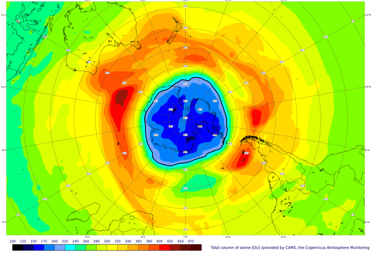
World governments agreed in the late 1980s to protect Earth’s ozone layer by phasing out ozone-depleting substances emitted by human activities, under the Montreal Protocol. The phase out of these substances has not only helped protect the ozone layer for future generations but has also protected human health and ecosystems by limiting the harmful ultraviolet radiation from reaching Earth. On 16 September, the International Day for the Preservation of the Ozone Layer, we take a closer look at this year’s ozone hole.
Vrchní referent / rada v oddělení dokumentace katastru nemovitostí Katastrálního pracoviště Jičín
16.9.2021 12:21 ČÚZK - předpisy a opatření Katastrální úřad pro Královéhradecký kraj - Katastrální pracoviště Jičínvypisuje výběrové řízení na místo
Vrchní referent / rada v oddělení dokumentace katastru nemovitostí Katastrálního pracoviště Jičín