


![]()

zprávy
zdroje zpráv:HazardHub and Bold Penguin Announce Strategic Alliance For Risk Evaluation
4.2.2021 17:19 GISCafe.com Webcasts-Webinars Two leading insurtechs integrate to both speed and sharpen the commercial insurance risk evaluation process.SAN DIEGO, Feb. 4, 2021 — …
Nové služby pro poskytování dat Databáze bodových polí
4.2.2021 16:00 ČÚZK - Geoportál Nové služby pro poskytování dat Databáze bodových políByla zveřejněna nová stahovací služba WFS Bodová pole z technologie ArcGIS Server, která je publikována dle standardu OGC WFS 2.0.0. Služba umožňuje bez nutnosti registrace opakované stahování prvků bodových polí v různých formátech. Služba má technické omezení počtu prvků, které lze stáhnout na jeden dotaz (10 000 prvků).
Součástí poskytnutých dat je vždy i URL odkaz na geodetické údaje o bodu - tj. webový formulář, který lze vytisknout ve formátu A4, s dalšími informacemi o bodu, včetně místopisu.
V otevřeném formátu pro reprezentaci geometrických objektů geoJSON je navíc možné stahovat (pomocí funkce Query) data bodových polí i prostřednictvím nové mapové služby ESRI ArcGIS Server. Služba má technické omezení počtu prvků, které lze stáhnout na jeden dotaz (2 000 prvků).
Tato služba poskytuje, kromě WFS rozhraní pro výše uvedenou stahovací službu, i WMS rozhraní pro poskytování nové prohlížecí služby dle standardu OGC WMS Bodová pole. Služba je dostupná např. v mapové kompozici Bodová pole v aplikaci Geoprohlížeč.
UPOZORNĚNÍ:
Původní WMS služba https://geoportal.cuzk.cz/WMS_BODPOLE/WMService.aspx?service=WMS&request=getCapabilities a rovněž WFS služba pro stahování dat s nutností registrace https://geoportal.cuzk.cz/wfs_bodpole/wfservice.aspx?service=wfs&request=getcapabilities již nebudou od 1. března 2021 podporovány.
CoreLogic Enters into Definitive Agreement to Be Acquired by Stone Point Capital and Insight Partners for $80 Per Share in Cash
4.2.2021 15:33 GISCafe.com Webcasts-Webinars IRVINE, Calif. & GREENWICH, Conn. — (BUSINESS WIRE) — February 4, 2021 —CoreLogic® (NYSE: CLGX), a leading global property …
Trimble Teams with ROBORACE for its Autonomous Racing Series
4.2.2021 15:33 GISCafe.com Webcasts-Webinars Trimble Named Official GNSS-Inertial Positioning Technology SupplierSUNNYVALE, Calif., Feb. 4, 2021 — (PRNewswire) — Trimble …
Atlas AI Launches Aperture™ - Unlocking Unparalleled Insight to Target Investment and Drive Impact in Emerging Markets
4.2.2021 15:33 GISCafe.com Webcasts-Webinars PALO ALTO, Calif., Feb. 4, 2021 — (PRNewswire) — Atlas AI today announced the launch of Aperture™, a market and economic …Geonexus and ActiveG Announce Strategic Partnership
4.2.2021 15:33 GISCafe.com Webcasts-Webinars Geonexus and ActiveG form strategic partnership to deliver a complete solution for IBM Maximo and Esri ArcGIS integration.ANN ARBOR, Mich., Feb. 4, …
Flirtey and Vault Conduct Drone Deliveries of At-Home COVID-19 Test Kits
4.2.2021 15:33 GISCafe.com Webcasts-Webinars RENO, Nev., Feb. 4, 2021 — (PRNewswire) — Flirtey, the pioneer of the commercial drone delivery industry, and Vault Health, the pioneer …Luokung Announces Partnership Between EMG and Leading Electric Vehicle Manufacturer BAIC BJEV to Jointly Develop Mapping Services for Autonomous Driving
4.2.2021 15:33 GISCafe.com Webcasts-Webinars BEIJING, Feb. 4, 2021 — (PRNewswire) — Luokung Technology Corp. (NASDAQ: LKCO) ("Luokung" or the "Company"), a leading interactive …HawkEye 360 Introduces "HawkEye RF Data Explorer" for Esri ArcGIS to Improve the Accessibility of Radio Frequency Intelligence
4.2.2021 15:33 GISCafe.com Webcasts-Webinars ArcGIS Pro add-in will help users easily ingest and visualize radio frequency dataHERNDON, Va., Feb. 4, 2021 — (PRNewswire) — …
Oznameni_o_vyhlaseni_vyberoveho_rizeni_OKO1_ch_2021
4.2.2021 15:21 ČÚZK - předpisy a opatření Katastrální úřad pro Karlovarský kraj odbor obnovy katastrálního operátuvypisuje výběrové řízení na místo
Oznameni_o_vyhlaseni_vyberoveho_rizeni_OKO1_ch_2021
Oznameni_o_vyhlaseni_vyberoveho_rizeni_OKO1_ch_2021
4.2.2021 15:21 ČÚZK - volná místa Katastrální úřad pro Karlovarský kraj odbor obnovy katastrálního operátu vypisuje výběrové řízení na místo Oznameni_o_vyhlaseni_vyberoveho_rizeni_OKO1_ch_2021Oznameni_o_vyhlaseni_vyberoveho_rizeni_OKO1_ch_2021
4.2.2021 15:21 ČÚZK /Urady/Katastralni-urady/Katastralni-urady/Katastralni-urad-pro-Karlovarsky-kraj/Uredni-deska/Oznameni-a-jina-uredni-sdeleni/Volna-mista/DMS/Oznameni_o_vyhlaseni_vyberoveho_rizeni_OKO1_ch_202Precisely and TomTom Help Companies Achieve Data Integrity Through Location Technology
4.2.2021 15:07 GISCafe.com Webcasts-Webinars AMSTERDAM and NEW YORK, Feb. 04, 2021 (GLOBE NEWSWIRE) -- TomTom (TOM2), the location technology specialist, and Precisely, the global leader in …DroneDeploy Secures $50M to Accelerate Development Beyond Drones and Solidify Global Market Leadership
4.2.2021 15:07 GISCafe.com Webcasts-Webinars SAN FRANCISCO, Feb. 04, 2021 (GLOBE NEWSWIRE) -- Leading enterprise drone data company DroneDeploy today announced it has raised $50 million in …Pořadatelé veletrhu Intergeo 2021 letos plánují skutečný veletrh, pokud to jen trochu situace s koronavirem dovolí
4.2.2021 13:58 ZeměměřičOrganizátoři mezinárodního veletrhu Intergeo, který se každoročně na podzim koná v Německu, oznámili, že pokud to situace dovolí, chtějí uspořádat „live trade fair“. Intergeo 2021 se bude konat ve dnech 21. – 23. září v Hannoveru. Po zkušenostech z podzimu, kdy se akce kvůli covid-19 nemohla konat, počítají samozřejmě také s digitální platformou. Aktuálně je k dispozici je rozložení stánků v halách […]
The post Pořadatelé veletrhu Intergeo 2021 letos plánují skutečný veletrh, pokud to jen trochu situace s koronavirem dovolí appeared first on Zeměměřič.
Katedra geomatiky ZČU v Plzni má od ledna nového vedoucího
4.2.2021 13:39 ZeměměřičNovým vedoucím katedry geomatiky na fakultě aplikovaných věd Západočeské univerzity v Plni se od 1. ledna 2021 stal Doc. Ing. Karel Janečka, Ph.D. Karel Janečka od června 2012 předsedá České asociaci pro geoinformace, jeho specializací je třetí rozměr v katastru nemovitostí. Karel Janečka je činný rovněž v Mezinárodní federaci zeměměřičů (FIG). 3D v katastru popsal v roce 2018 v publikaci Best Practices […]
The post Katedra geomatiky ZČU v Plzni má od ledna nového vedoucího appeared first on Zeměměřič.
Katedra geomatiky ZČU v Plzni má od ledna nového vedoucího
4.2.2021 13:39 ZeměměřičNovým vedoucím katedry geomatiky na fakultě aplikovaných věd Západočeské univerzity v Plni se od 1. ledna 2021 stal Doc. Ing. Karel Janečka, Ph.D. Karel Janečka od června 2012 předsedá České asociaci pro geoinformace, jeho specializací je třetí rozměr v katastru nemovitostí. Karel Janečka je činný rovněž v Mezinárodní federaci zeměměřičů (FIG). O 3D pro katastr se zapojil v roce 2018 do […]
The post Katedra geomatiky ZČU v Plzni má od ledna nového vedoucího appeared first on Zeměměřič.
Jack Dangermond, digitální dvojčata, jazyk R, 3D i ArcGIS Urban. Geodesign Summit se koná i letos, i když virtuálně
4.2.2021 13:19 GeoBusinessSpolečnost Esri také letos pořádá Geodesign Summit. Firma zde představí technologické novinky a různé tipy pro práci s daty v oborech územního plánování a urbanismu. Vstup na Geodesign Summit je zdarma, akce se bude konat ve dnech 8. až 11. února 2021. Součástí konference jsou také workshopy 8. a 11. února. V úvodu konference vystoupí […]
The post Jack Dangermond, digitální dvojčata, jazyk R, 3D i ArcGIS Urban. Geodesign Summit se koná i letos, i když virtuálně appeared first on GeoBusiness.
Jack Dangermond, digitální dvojčata, jazyk R, 3D i ArcGIS Urban. Geodesign Summit se koná také letos, i když jen virtuálně
4.2.2021 13:19 GeoBusinessSpolečnost Esri také letos pořádá Geodesign Summit. Firma zde představí technologické novinky a různé tipy pro práci s daty v oborech územního plánování a urbanismu. Vstup na Geodesign Summit je zdarma, akce se bude konat ve dnech 8. až 11. února 2021. Součástí konference jsou také workshopy 8. a 11. února. V úvodu konference vystoupí […]
The post Jack Dangermond, digitální dvojčata, jazyk R, 3D i ArcGIS Urban. Geodesign Summit se koná také letos, i když jen virtuálně appeared first on GeoBusiness.
Jack Dangermond, digitální dvojčata, jazyk R, 3D i ArcGIS Urban. Geodesign Summit je i letos
4.2.2021 13:19 GeoBusinessSpolečnost Esri také letos pořádá Geodesign Summit. Firma zde představí technologické novinky a různé tipy pro práci s daty v oborech územního plánování a urbanismu. Vstup na Geodesign Summit je zdarma, akce se bude konat ve dnech 8. až 11. února 2021. Součástí konference jsou také workshopy 8. a 11. února. V úvodu konference vystoupí […]
The post Jack Dangermond, digitální dvojčata, jazyk R, 3D i ArcGIS Urban. Geodesign Summit je i letos appeared first on GeoBusiness.
Aeolus shines a light on polar vortex
4.2.2021 11:45 ESA Observing the Earth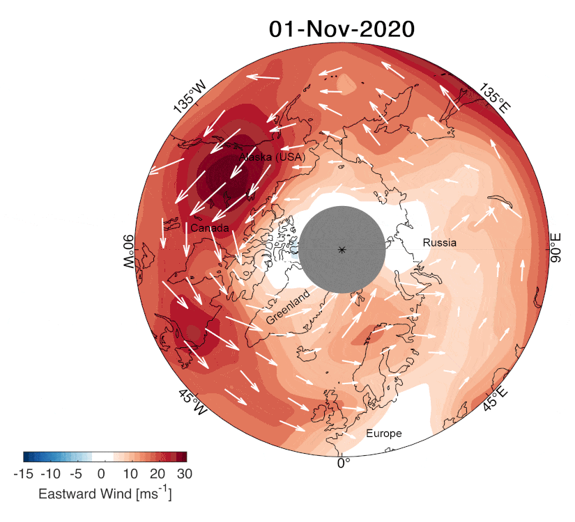
As this winter’s polar vortex currently sends extreme icy blasts of Arctic weather to some parts of the northern hemisphere such as the northeast of the US, scientists are using wind information from ESA’s Aeolus satellite to shed more light on this complex phenomenon.
rozhodování o povolení vkladu
4.2.2021 11:34 ČÚZK - volná místa Katastrální úřad pro Olomoucký kraj - Katastrální pracoviště Šumperk vypisuje výběrové řízení na místo rozhodování o povolení vkladurozhodování o povolení vkladu
4.2.2021 11:34 ČÚZK - předpisy a opatření Katastrální úřad pro Olomoucký kraj - Katastrální pracoviště Šumperkvypisuje výběrové řízení na místo
rozhodování o povolení vkladu
Pozvánka na virtuální Geodesign Summit 2021
4.2.2021 9:38 ARCDATAV letošním roce pořádá společnost Esri již 12. ročník oborové konference Geodesign Summit, která se zabývá urbanismem a efektivním využitím technologií GIS v oblasti územního plánování.
Během Geodesign Summitu se například dozvíte, proč má smysl budovat digitální dvojče, jak co nejlépe využívat aktuální data či jak vám moderní technologie GIS pomohou posoudit dopady plánovaných změn a zlepšit komunikaci s odbornou i laickou veřejností.
Pokud chcete načerpat novou inspiraci nebo vás jen zajímá, kam se obor urbanismu ubírá, připojte se 9.–10. února 2021 k účastníkům akce. Geodesign Summit 2021 se bude konat virtuálně a je zdarma – stačí se jen zaregistrovat na webových stránkách akce.
Další informace a podrobný program naleznete na webových stránkách Esri.

Přihlaste svou bakalářku do soutěže
4.2.2021 9:30 Katedra geoinformatiky UP OlomoucMáme zajímavý tip pro všechny naše studentky od Czechitas 🙂 Napsala jsi úspěšně svou bakalářku na téma související IT? Chceš realizovat svůj projekt? Přihlas se do soutěže Cena Czechitas a získej mentoring od odborníků z praxe. Registruj se do 28. 2. 2021 na czechitas.cz/CenaCzechitas.
The post Přihlaste svou bakalářku do soutěže appeared first on Katedra geoinformatiky.
Webová kartografie – rozhovor s autorem nové knihy + soutěž!
4.2.2021 8:14 GISportal.cz
Na konci loňského roku vyšla na Katedře geoinformatiky v Olomouci nová publikace o webové kartografii (Nétek, R. (2020). Webová kartografie – specifika tvorby interaktivních map na webu. Univerzita Palackého v Olomouci. 196 s. ISBN 978-80-244-5827-4.). S jejím autorem a naším kamarádem Dr. Rosťou Nétkem jsme si povídali o této knize a také připravili soutěž o […]
The post Webová kartografie – rozhovor s autorem nové knihy + soutěž! appeared first on GISportal.cz.
Nová kniha o webové kartografii
4.2.2021 7:00 Česká asociace pro geoinformace Tip na knihu z Katedry geoinformatiky Univerzity Palackého v Olomouci od dr. Rostislava Nétka (2020): Webová kartografie - specifika tvorby interaktivních map na webu. Jedná se o první publikaci komplexně popisující aspekty a principy webové kartografie.Únorové a březnové online BIM akce CAD Studia
4.2.2021 1:00 CAD Studio V letošním únorovém a březnovém kalendáři online akcí CAD Studia nyní najdete sérii specializovaných online školení a webinářů zaměřených na různé profese z oblasti BIM projektování pozemních a inženýrských staveb. Díky těmto krátkým online akcím ...Státní pozemkový úřad zveřejnil financování pozemkových úprav za rok 2020
4.2.2021 0:00 Státní pozemkový úřad Praha, 4. února 2021 - Státní pozemkový úřad (SPÚ) vyčerpal v roce 2020 na pozemkové úpravy finanční prostředky ve výši 700 milionů korun ze Všeobecné pokladní správy, 610 milionů korun z rozpočtu MZe, 48 milionů korun z rozpočtu SPÚ, přibližně 134 milionů korun na předfinancování projektů z Programu rozvoje venkova a 3,5 milionů korun z Operačního programu Životní prostředí (OPŽP).Na webových stránkách naší spo
4.2.2021 0:00 SolidVision Na webových stránkách naší společnosti je v sekci Podpora > Ke stažení k dispozici SP1 pro SOLIDWORKS 2021.Na webových stránkách naší spo
4.2.2021 0:00 SolidVision Na webových stránkách naší společnosti je v sekci Podpora > Ke stažení k dispozici SP1 pro SOLIDWORKS 2021.Dronecode Foundation Announces Appointment of New Board Directors
3.2.2021 18:11 GISCafe.com Webcasts-Webinars SAN FRANCISCO, Feb. 3, 2021 — (PRNewswire) — The Dronecode Foundation, the vendor-neutral Foundation for open source drone projects, …Referent KN – návrh zápisu, kontrola a zplatnění v PO VI
3.2.2021 17:08 ČÚZK - volná místa Katastrální úřad pro hlavní město Prahu vypisuje výběrové řízení na místo Referent KN – návrh zápisu, kontrola a zplatnění v PO VIReferent KN – návrh zápisu, kontrola a zplatnění v PO VI
3.2.2021 17:08 ČÚZK /Urady/Katastralni-urady/Katastralni-urady/Katastralni-urad-pro-hlavni-mesto-Prahu/Volna-mista/DMS/Referent-KN-–-navrh-zapisu,-kontrola-a-zplatneni-vReferent KN – návrh zápisu, kontrola a zplatnění v PO VI
3.2.2021 17:08 ČÚZK - předpisy a opatření Katastrální úřad pro hlavní město Prahuvypisuje výběrové řízení na místo
Referent KN – návrh zápisu, kontrola a zplatnění v PO VI
Referent KN – vedení DKM, vedení katastrální mapy, PT 11
3.2.2021 17:06 ČÚZK - předpisy a opatření Katastrální úřad pro hlavní město Prahu Katastrální pracoviště Prahavypisuje výběrové řízení na místo
Referent KN – vedení DKM, vedení katastrální mapy, PT 11
Referent KN – vedení DKM, vedení katastrální mapy, PT 11
3.2.2021 17:06 ČÚZK /Urady/Katastralni-urady/Katastralni-urady/Katastralni-urad-pro-hlavni-mesto-Prahu/Volna-mista/DMS/Referent-KN-–-vedeni-DKM,-vedeni-katastralni-mapy,Referent KN – vedení DKM, vedení katastrální mapy, PT 11
3.2.2021 17:06 ČÚZK - volná místa Katastrální úřad pro hlavní město Prahu Katastrální pracoviště Praha vypisuje výběrové řízení na místo Referent KN – vedení DKM, vedení katastrální mapy, PT 11Referent KN – právník do právního oddělení XI
3.2.2021 17:05 ČÚZK /Urady/Katastralni-urady/Katastralni-urady/Katastralni-urad-pro-hlavni-mesto-Prahu/Volna-mista/DMS/Referent-KN-–-pravnik-do-pravniho-oddeleni-XIReferent KN – právník do právního oddělení XI
3.2.2021 17:05 ČÚZK - předpisy a opatření Katastrální úřad pro hlavní město Prahu Katastrální pracoviště Prahavypisuje výběrové řízení na místo
Referent KN – právník do právního oddělení XI
Referent KN – právník do právního oddělení XI
3.2.2021 17:05 ČÚZK - volná místa Katastrální úřad pro hlavní město Prahu Katastrální pracoviště Praha vypisuje výběrové řízení na místo Referent KN – právník do právního oddělení XIReferent KN-vedení katastrální mapy PT 10
3.2.2021 16:44 ČÚZK - volná místa Katastrální úřad pro hlavní město Prahu vypisuje výběrové řízení na místo Referent KN-vedení katastrální mapy PT 10Referent KN-vedení katastrální mapy PT 10
3.2.2021 16:44 ČÚZK - předpisy a opatření Katastrální úřad pro hlavní město Prahuvypisuje výběrové řízení na místo
Referent KN-vedení katastrální mapy PT 10
Referent KN-vedení katastrální mapy PT 10erát_
3.2.2021 16:44 ČÚZK - volná místa Katastrální úřad pro hlavní město Prahu Katastrální pracoviště Praha vypisuje výběrové řízení na místo Referent KN-vedení katastrální mapy PT 10erát_Referent KN-vedení katastrální mapy PT 10
3.2.2021 16:44 ČÚZK /Urady/Katastralni-urady/Katastralni-urady/Katastralni-urad-pro-hlavni-mesto-Prahu/Volna-mista/DMS/Referent-KN-vedeni-katastralni-mapy-PT-10erat_Referent KN-vedení katastrální mapy PT 10erát_
3.2.2021 16:44 ČÚZK /Urady/Katastralni-urady/Katastralni-urady/Katastralni-urad-pro-hlavni-mesto-Prahu/Volna-mista/DMS/Referent-KN-vedeni-katastralni-mapy-PT-10erat_Referent KN-vedení katastrální mapy PT 10erát_
3.2.2021 16:44 ČÚZK - předpisy a opatření Katastrální úřad pro hlavní město Prahu Katastrální pracoviště Prahavypisuje výběrové řízení na místo
Referent KN-vedení katastrální mapy PT 10erát_
Trimble Introduces the Next Generation of 3D Paving Control for Asphalt Pavers
3.2.2021 16:24 GISCafe.com Webcasts-Webinars Trimble Roadworks Advances Asphalt Paving Control with Intuitive Software, Rugged Hardware and Office-to-Field InterconnectivitySUNNYVALE, Calif., …
Esri Releases ArcGIS Velocity for Analysis of Real-Time IoT Data
3.2.2021 16:24 GISCafe.com Webcasts-Webinars Additional License Levels Open Opportunities for New Industries to Integrate Geospatial Sensor CapabilityREDLANDS, Calif. — (BUSINESS WIRE) …
Quanergy Unveils 3D LiDAR People Counting Solution with Widest Coverage Area on the Market
3.2.2021 16:24 GISCafe.com Webcasts-Webinars Provides up to 30m coverage and 98% accuracy in indoor and outdoor lighting conditionsIdeally suited for challenging, low mounting heights and …
NV5 Geospatial Experts to Speak at Coastal GeoTools 2021
3.2.2021 16:24 GISCafe.com Webcasts-Webinars Presentations Showcase Use of Topobathymetric Lidar for USGS 3DEP, Elevation Modeling and Urban Water Conservation, and Decision Support Tool for …Vrchní referent / rada – správa dokumentace katastru v oddělení dokumentace
3.2.2021 14:51 ČÚZK - předpisy a opatření Katastrální úřad pro Zlínský kraj Katastrální pracoviště Zlínvypisuje výběrové řízení na místo
Vrchní referent / rada – správa dokumentace katastru v oddělení dokumentace
Vrchní referent / rada – správa dokumentace katastru v oddělení dokumentace
3.2.2021 14:51 ČÚZK /Urady/Katastralni-urady/Katastralni-urady/Katastralni-urad-pro-Zlinsky-kraj/Uredni-deska/Oznameni-a-jina-uredni-sdeleni/Volna-mista/DMS/Vrchni-referent-rada-–-sprava-dokumentace-katastVrchní referent / rada – správa dokumentace katastru v oddělení dokumentace
3.2.2021 14:51 ČÚZK - volná místa Katastrální úřad pro Zlínský kraj Katastrální pracoviště Zlín vypisuje výběrové řízení na místo Vrchní referent / rada – správa dokumentace katastru v oddělení dokumentaceOsobní automobil Škoda Fabia 1.2
3.2.2021 14:06 ČÚZK /Urady/Katastralni-urady/Katastralni-urady/Katastralni-urad-pro-Jihocesky-kraj/Nabidky-majetku/Osobni-automobil-Skoda-Fabia-1-2Osobní automobil Škoda Fabia 1.2
3.2.2021 14:06 ČÚZK - předpisy a opatřeníKatastrální úřad pro Jihočeský kraj nabízí nepotřebný majetek k odkupu. Jedná se o
Osobní automobil Škoda Fabia 1.2
Změna úředních hodin
3.2.2021 13:01 ČÚZK - předpisy a opatření Katastrální úřad pro Liberecký kraj - Katastrální pracoviště Liberec zveřejnil novou aktualitu: S ohledem na epidemiologickou situaci se od 8. 2. 2021 mění úřední hodiny:Pondělí 8 – 13
Středa 12 - 17
Podání se zasílají poštou. Osobně přinesená vkládejte do schránky u vchodu - veškeré žádosti včetně návrhů na vklad. Uveďte eMail, zašleme Vám platební údaje a potvrzení o převzetí (např. kopii s podacím razítkem). Vkládejte v uzavřené obálce max. A4, vybíráme průběžně každý den. Zkontrolujte, zda je návrh na vklad podepsaný.
Podrobnosti zde.
Návrh na vklad: aplikace.
Podrobnosti o elektronickém podání.
Stav komunikací II. a III. třídy
3.2.2021 12:20 Jihočeský kraj Mapová aplikace Stav komunikací II. a III. třídy byla aktualizována o rok 2020.Is this the end of the A-68A iceberg?
3.2.2021 12:05 ESA Observing the Earth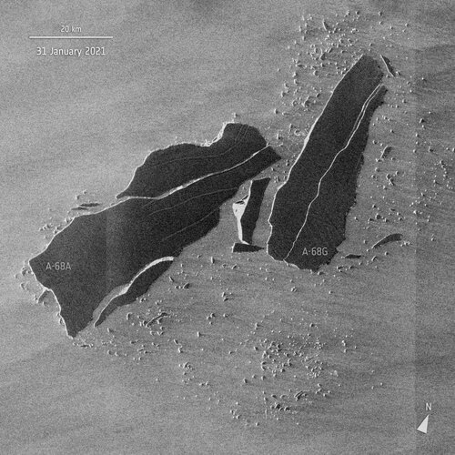
Satellite images have revealed that the once colossal A-68A iceberg has had yet another shattering experience. Several large cracks were spotted in the berg last week and it has since broken into multiple pieces. These little icebergs could indicate the end of A-68A’s environmental threat to South Georgia.
Zveřejnění obsahu informací poskytnutých na žádost dle zákona č. 106/1999 Sb. za rok 2021
3.2.2021 11:06 ČÚZK /Urady/Cesky-urad-zememericky-a-katastralni/Casto-hledane-informace/Poskytovani-informaci-106-1999-Sb/Zverejneni-obsahu-informaci-poskytnutych-na-za-(1)/Rok2008-2013/Zverejneni-obsahu-informaci-poskytnutych-na-za-(3)Zveřejnění obsahu informací poskytnutých na žádost dle zákona č. 106/1999 Sb. za rok 2021
3.2.2021 11:06 ČÚZK - předpisy a opatření Český úřad zeměměřický a katastrálnízveřejňuje obsah informace poskytnutých na žádost dle zákona č. 106/1999 Sb. za rok
2021
Zveřejnění obsahu informací poskytnutých na žádost dle zákona č. 106/1999 Sb. za rok 2021
3.2.2021 11:06 ČÚZK - předpisy a opatření Český úřad zeměměřický a katastrálnízveřejňuje obsah informace poskytnutých na žádost dle zákona č. 106/1999 Sb. za rok
2021
Zveřejnění obsahu informací poskytnutých na žádost dle zákona č. 106/1999 Sb. za rok 2021
3.2.2021 11:06 ČÚZK /Urady/Cesky-urad-zememericky-a-katastralni/Casto-hledane-informace/Poskytovani-informaci-106-1999-Sb/Zverejneni-obsahu-informaci-poskytnutych-na-za-(1)/Zverejneni-obsahu-informaci-poskytnutych-na-za-(3)Aktualizace Základní mapy 1:200 000
3.2.2021 9:19 ČÚZK - Geoportál Aktualizace Základní mapy 1:200 000Rastrová data Základní mapy 1:200 000 byla aktualizována.
Aktualizace probíhá u tohoto produktu najednou po 2 až 3 letech pro celé území ČR. Poslední vydání je z roku 2020. Stav silničních komunikací odpovídá minimálně 1. 7. 2020. Stav správního členění již odpovídá zákonu č. 51/2020 Sb., o územně správním členění státu, platnému od 1. 1. 2021.
Nové soubory ve formátu TIF již lze objednávat v aplikaci e-shop. Příslušné prohlížecí služby WMS ZM 200 a služby AGS a WMTS pro Základní mapy jsou již také aktualizovány a jsou dostupné například v aplikaci Geoprohlížeč.
Aktualizace Základní mapy 1:200 000
3.2.2021 9:19 ČÚZK - Geoportál Aktualizace Základní mapy 1:200 000Rastrová data Základní mapy 1:200 000 byla aktualizována.
Aktualizace probíhá u tohoto produktu najednou po 2 až 3 letech pro celé území ČR. Poslední vydání je z roku 2020. Stav silničních komunikací odpovídá minimálně 1. 7. 2020. Stav správního členění již odpovídá zákonu č. 51/2020 Sb., o územně správním členění státu, platnému od 1. 1. 2021.
Nové soubory ve formátu TIF již lze objednávat v aplikaci e-shop. Příslušné prohlížecí služby WMS ZM 200 a služby AGS a WMTS pro Základní mapy jsou již také aktualizovány a jsou dostupné například v aplikaci Geoprohlížeč.
Ukončení EGON služby E41 isknCtiVlastniky
3.2.2021 9:09 ČÚZK /Aplikace-DP-do-KN/Aplikace-DP-do-KN/Archiv-DP/313324Ukončení EGON služby E41 isknCtiVlastniky
3.2.2021 9:09 Dálkový přístup k údajům KN ČROznamujeme ukončení poskytování EGON služby E41 isknCtiVlastniky k 31.8.2021. Služba E41 je plně nahrazena E238 isknCtiVlastniky2.
Více informací je možné nalézt na našich stránkách https://www.cuzk.cz/Katastr-nemovitosti/Poskytovani-udaju-z-KN/Informace-poskytovane-prostrednictvim-eGON-sluzeb.aspx a nebo přímo na stránkách SZR https://www.szrcr.cz/cs/archiv-novinek/vyvojari-a-spravci-ais/166-nov%C3%A1-verze-katalogu-egon-slu%C5%BEeb-3.
Doporučujeme přejít na využívání nové služby E238 isknCtiVlastniky2 co nejdříve, nejpozději do konce srpna 2021.
Ukončení EGON služby E41 isknCtiVlastniky
3.2.2021 9:09 ČÚZK - předpisy a opatřeníOznamujeme ukončení poskytování EGON služby E41 isknCtiVlastniky k 31.8.2021. Služba E41 je plně nahrazena E238 isknCtiVlastniky2.
Více informací je možné nalézt na našich stránkách https://www.cuzk.cz/Katastr-nemovitosti/Poskytovani-udaju-z-KN/Informace-poskytovane-prostrednictvim-eGON-sluzeb.aspx a nebo přímo na stránkách SZR https://www.szrcr.cz/cs/archiv-novinek/vyvojari-a-spravci-ais/166-nov%C3%A1-verze-katalogu-egon-slu%C5%BEeb-3.
Doporučujeme přejít na využívání nové služby E238 isknCtiVlastniky2 co nejdříve, nejpozději do konce srpna 2021.
Na webových stránkách naší spo
3.2.2021 0:00 SolidVision Na webových stránkách naší společnosti je v sekci Podpora > Ke stažení k dispozici SP5 pro SOLIDWORKS 2020.Na webových stránkách naší spo
3.2.2021 0:00 SolidVision Na webových stránkách naší společnosti je v sekci Podpora > Ke stažení k dispozici SP5 pro SOLIDWORKS 2020.ASPRS ANNOUNCES STUDENT CONFERENCE PRESENTATION GRANTS!
2.2.2021 21:20 GISCafe.com Webcasts-Webinars February 02, 2021 -- ASPRS, with support of the ASPRS Foundation, has identified funding to sponsor Student Presentations in the upcoming ASPRS 2021 …Dedrone First to Offer Both United States and European Union Drone Remote ID Capability
2.2.2021 17:41 GISCafe.com Webcasts-Webinars Global airspace security leader enables its customers to leverage global Remote ID standards to identify drones and their pilotsSAN FRANCISCO, Feb. …
Onward and Upward: Annual US Home Price Appreciation in 2020 Outpaced 2019 Levels by 50%, CoreLogic Reports
2.2.2021 16:07 GISCafe.com Webcasts-Webinars U.S. Home Price Index up 9.2% in December from a year earlier, largest annual gain in more than six years fueled by low inventory and attractive …MDA Announces RADARSAT-2 Continuity Mission
2.2.2021 16:07 GISCafe.com Webcasts-Webinars BRAMPTON, ON, Feb. 2, 2021 — (PRNewswire) —New satellite mission will provide advanced commercialEarth observation imagery, products …
Satellite observations prove crucial in new climate science report
2.2.2021 15:15 ESA Observing the Earth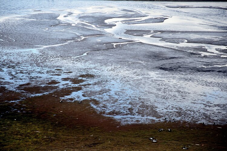
With impacts from climate change threatening major disruption to society in the coming years, leading scientists have released a compilation of the 10 most important insights on climate to help inform collective action on the ongoing climate crisis, in which satellites have played a crucial role in aiding scientific understanding.
Leica Zeno FLX100
2.2.2021 12:15 GEFOS Univerzální GIS/GNSS přijímač s 2 cm přesností k vlastnímu mobilu, tabletu nebo na tyčku. Použijete ho s vlastním softwarem nebo s aplikací Leica Zeno Mobile pro snadný sběr GIS dat.Aktualizovaná verze okruhů k SZZ v. 2021
2.2.2021 11:15 Katedra geoinformatiky UP OlomoucV sekci Dokumenty byly zveřejněny aktuální okruhy ke Státním závěrečným zkouškám platné pro akademický rok 2020/21. Samostatný dokument je pro bakalářské a magisterské studium.
The post Aktualizovaná verze okruhů k SZZ v. 2021 appeared first on Katedra geoinformatiky.
revize 2021
2.2.2021 11:01 ČÚZK - předpisy a opatření Katastrální úřad pro Ústecký kraj - Katastrální pracoviště Louny zveřejnil novou aktualitu: Vážení klienti, oznamujeme Vám, že v roce 2021 budou postupně probíhat revize katastru nemovitostí v katastrálních územích Břvany, Hřivice, Touchovice, Markvarec u Hřivic, Domoušice, Konětopy u Pnětluk, Pnětluky a v současné době se dokončuje revize v k.ú. Výškov u Počerad. Předmětem revize jsou zejména zápisy staveb, druhu a způsobu využití pozemků, kdy výsledkem by mělo být dosažení co nejlepšího souladu katastru nemovitostí se skutečným stavem v terénu. O přesném termínu zahájení revize budete informováni obecním úřadem způsobem v místě obvyklém.revize 2021
2.2.2021 11:01 ČÚZK /Urady/Katastralni-urady/Katastralni-urady/Katastralni-urad-pro-Ustecky-kraj/Katastralni-pracoviste/KP-Louny/O-uradu/Aktuality/revize-2021revize 2021
2.2.2021 11:01 ČÚZK - předpisy a opatření Katastrální úřad pro Ústecký kraj - Katastrální pracoviště Louny zveřejnil novou aktualitu: Vážení klienti, oznamujeme Vám, že v roce 2021 budou postupně probíhat revize katastru nemovitostí v katastrálních územích Břvany, Hřivice, Touchovice, Markvarec u Hřivic, Domoušice, Konětopy u Pnětluk, Pnětluky a v současné době se dokončuje revize v k.ú. Výškov u Počerad. Předmětem revize jsou zejména zápisy staveb, druhu a způsobu využití pozemků, kdy výsledkem by mělo být dosažení co nejlepšího souladu katastru nemovitostí se skutečným stavem v terénu. O přesném termínu zahájení revize budete informováni obecním úřadem způsobem v místě obvyklém.revize 2022
2.2.2021 11:01 ČÚZK - předpisy a opatření Katastrální úřad pro Ústecký kraj - Katastrální pracoviště Louny zveřejnil novou aktualitu: Vážení klienti, oznamujeme Vám, že v roce 2022 budou postupně probíhat revize katastru nemovitostí v katastrálních územích Domoušice, Solopysky, Pnětluky, Konětopy u Pnětluk, Břínkov (intravilán), Úlovice (intravilán), Dolní Ročov (mimo oblast pozemkové úpravy a mapování), Divice, Brodec, Smolnice u Loun. Předmětem revize jsou zejména zápisy staveb, druhu a způsobu využití pozemků, kdy výsledkem by mělo být dosažení co nejlepšího souladu katastru nemovitostí se skutečným stavem v terénu. O přesném termínu zahájení revize budete informováni obecním úřadem způsobem v místě obvyklém.Zároveň od 2. čtvrtletí budou pokračovat práce na novém mapování v k.ú. Horní Ročov.
revize 2022
2.2.2021 11:01 ČÚZK /Urady/Katastralni-urady/Katastralni-urady/Katastralni-urad-pro-Ustecky-kraj/Katastralni-pracoviste/KP-Louny/O-uradu/Aktuality/revize-2021Webináře Otevřené jaro – program na únor 2021
2.2.2021 10:27 GISportal.cz
Plan4all pokračuje v pořádání série webinářů Otevřené jaro, která se koná každé úterý vždy ve 13:00 hod. Témata únorových webinářů jsou již zveřejněná na stránce https://www.otevrenejaro.cz/program/ 2.2.2021, 13:00 Webinář 4: Agronode – autonomní telemetrická IoT stanice 9.2.2021, 13:00 Webinář 5: AgriHub – české zemědělské inovační centrum 16.2.2021, 13:00 Webinář 6: Lesprojekt Cloud – prostředí pro aplikace a […]
The post Webináře Otevřené jaro – program na únor 2021 appeared first on GISportal.cz.
Představili jsme nové video o pozemkových úpravách
2.2.2021 9:20 Asociace podnikatelů v geomatice Začátkem roku jsme představili nové propagační video, které upozorňuje na problematiku pozemkových úprav. Video jsme rozeslali všem našim partnerům, kterých se tato problematika dotýká – poslancům, se kterými dlouhodobě o pozemkových úpravách jednáme, zástupcům Ministerstva zemědělství, Ministerstva životního prostředí, SPÚ a na další partnerské a spolupracující organizace, stejně tak jako na vzdělávací a vědecké instituce. Těší nás, že video […]Earth observation vital in monitoring wetland waters
2.2.2021 9:00 ESA Observing the Earth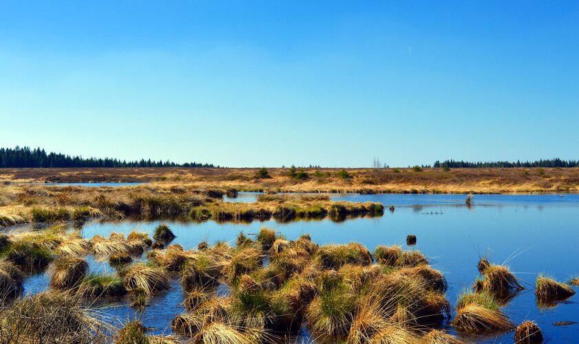
Celebrated annually on 2 February, World Wetlands Day aims to raise global awareness about the importance of wetlands for our planet. This year’s theme shines a light on wetlands as a source of freshwater and encourages actions to restore them. From their vantage point of 800 km high, Earth-observing satellites provide data and imagery on wetlands that can be used to monitor and manage these precious resources sustainably.
V Brně vzniká platforma pro umělou inteligenci Brno.AI (TZ)
2.2.2021 8:59 GISportal.cz
Autonomní auto, recepční, aplikace pro nevidomé, ale i rozpoznávání hlasu, virtuální elektrárna nebo vývoj léku proti koronaviru – tam všude má své místo umělá inteligence. A právě její větší využití v praktickém životě si dali za cíl brněnští odborníci z oblasti umělé inteligence, kteří ve čtvrtek představili společnou platformu Brno.ai. Stojí za ní nejen odborníci z VUT v Brně […]
The post V Brně vzniká platforma pro umělou inteligenci Brno.AI (TZ) appeared first on GISportal.cz.
Nová kniha o webové kartografii
2.2.2021 8:33 Katedra geoinformatiky UP OlomoucNétek R. (2020): Webová kartografie – specifika tvorby interaktivních map na webu. První publikace komplexně popisující aspekty a principy webové kartografie‼ Doporučujeme✔ https://webova.kartografie.upol.cz/
The post Nová kniha o webové kartografii appeared first on Katedra geoinformatiky.
Asistent/ka
2.2.2021 8:23 ČÚZK - volná místa Zeměměřický úřad vypisuje výběrové řízení na místo Asistent/kaAsistent/ka
2.2.2021 8:23 Zeměměřický úřad Zeměměřický úřadvypisuje výběrové řízení na místo
Asistent/ka
Přerušení provozu DP a WSDP ve pondělí 8.2.2021 od 20:00 do cca 23:00.
2.2.2021 6:45 ČÚZK /Aplikace-DP-do-KN/Aplikace-DP-do-KN/Archiv-DP/313090Přerušení provozu DP a WSDP ve pondělí 8.2.2021 od 20:00 do cca 23:00.
2.2.2021 6:45 ČÚZK - předpisy a opatření Vážení uživatelé,oznamujeme, že ve pondělí 8.2.2021 od 20:00 bude z provozních důvodů zcela přerušen provoz Dálkového přístupu i Webových služeb dálkového přístupu. Obnovení provozu předpokládáme v cca 23:00 hodin.
Za komplikace tímto způsobené se omlouváme a děkujeme za pochopení.
Přerušení provozu DP a WSDP ve pondělí 8.2.2021 od 20:00 do cca 23:00.
2.2.2021 6:45 Dálkový přístup k údajům KN ČR Vážení uživatelé,oznamujeme, že ve pondělí 8.2.2021 od 20:00 bude z provozních důvodů zcela přerušen provoz Dálkového přístupu i Webových služeb dálkového přístupu. Obnovení provozu předpokládáme v cca 23:00 hodin.
Za komplikace tímto způsobené se omlouváme a děkujeme za pochopení.
APGEO - Představili jsme nové video o pozemkových úpravách
2.2.2021 1:00 Asociace podnikatelů v geomatice Začátkem roku jsme představili nové propagační video, které upozorňuje na problematiku pozemkových úprav...L3Harris Technologies Named Among FORTUNE’s 2021 World’s Most Admired Companies
2.2.2021 0:44 GISCafe.com Webcasts-Webinars MELBOURNE, Fla. — (BUSINESS WIRE) — February 1, 2021 —L3Harris Technologies (NYSE:LHX) has been named among FORTUNE’s 2021 …
Interview discussing PlaceKey with Ross Epstein, VP of New Projects, SafeGraph
2.2.2021 0:43 GISCafe.com Webcasts-WebinarsPublic comment sought on v1.1 of OGC Coverage Implementation Schema (CIS) - ReferenceableGridCoverage Extension
1.2.2021 21:47 GISCafe.com Webcasts-Webinars
CIS extension revision enables OGC imagery-related standards to more concisely represent remotely-sensed imagery
1 …
Vrchní referent / rada – řízení o údajích SGI v oddělení aktualizace KN Katastrálního pracoviště Zlí
1.2.2021 16:46 ČÚZK - volná místa Katastrální úřad pro Zlínský kraj Katastrální pracoviště Zlín vypisuje výběrové řízení na místo Vrchní referent / rada – řízení o údajích SGI v oddělení aktualizace KN Katastrálního pracoviště ZlíVrchní referent / rada – řízení o údajích SGI v oddělení aktualizace KN Katastrálního pracoviště Zlí
1.2.2021 16:46 ČÚZK - předpisy a opatření Katastrální úřad pro Zlínský kraj Katastrální pracoviště Zlínvypisuje výběrové řízení na místo
Vrchní referent / rada – řízení o údajích SGI v oddělení aktualizace KN Katastrálního pracoviště Zlín
Vrchní referent / rada – řízení o údajích SGI v oddělení aktualizace KN Katastrálního pracoviště Zlí
1.2.2021 16:46 ČÚZK /Urady/Katastralni-urady/Katastralni-urady/Katastralni-urad-pro-Zlinsky-kraj/Uredni-deska/Oznameni-a-jina-uredni-sdeleni/Volna-mista/DMS/Vrchni-referent-rada-–-rizeni-o-udajich-SGI-v-odPlaceiq Acquires Skyhook's Geospatial Insights Business Line
1.2.2021 16:22 GISCafe.com Webcasts-Webinars NEW YORK, Feb. 1, 2021 — (PRNewswire) — PlaceIQ Inc., the leading data and technology provider that powers critical business …SunPower and EagleView Automate Home Survey Process for Faster, More Precise Solar Installations
1.2.2021 16:22 GISCafe.com Webcasts-Webinars Computer vision, machine-learning enable dealers to create precise, construction-ready designs without drones or in-home surveysSAN JOSE, Calif., …
Nabídka certifikovaných kurzů z pohodlí domova
1.2.2021 16:02 ARCDATAChcete si zdokonalit své dovednosti v oblastí prostorových analýz a tvorby map, nebo si třeba jen udržet krok s vývojem technologií GIS? Pak nepřehlédněte MOOC (Massive Open Online Courses) – ucelené online kurzy zaměřené vždy na konkrétní problematiku.
Pro letošek jsou v nabídce následující témata:
- Cartography
- Do-It-Yourself Geo Apps
- The Location Advantage
- Going Places with Spatial Analysis
- Spatial Data Science: The New Frontier in Analytics
Doba trvání jednoho kurzu je od čtyř do šesti týdnů a účastníci si sami řídí tempo, kterým se budou kurzu věnovat. Každá lekce se skládá z výukových videí a několika samostatných cvičení. Po dokončení kurzu jeho účastníci obdrží certifikát.
První kurz zaměřený na kartografii začíná již 3. února 2021 a přihlašovat se na něj můžete na webových stránkách Esri.