


![]()

zprávy
zdroje zpráv:Aktualizovaná data ortofota ČR
10.2.2021 11:00 ČÚZK - Geoportál Aktualizovaná data ortofota ČRV rozsahu 1/2 ČR - východní poloviny území - byl aktualizován produkt Ortofoto ČR.
Data byla zpracována z leteckého snímkování v roce 2020. Přesné datum pořízení snímků pro jednotlivé mapové listy a přesný rozsah aktualizovaného území viz Stav aktualizace.
Nové soubory ortofota ve formátu JPEG již lze objednávat v e-shopu.
Prohlížecí služby Ortofoto WMS, WMTS a ArcGIS Server (včetně verzí Web Mercator) jsou již také aktualizovány a jsou dostupné například v aplikacích Geoprohlížeč, Nahlížení do KN, nebo Analýzy výškopisu.
Aktualizovaná data ortofota ČR
10.2.2021 11:00 ČÚZK - Geoportál Aktualizovaná data ortofota ČRV rozsahu 1/2 ČR - východní poloviny území - byl aktualizován produkt Ortofoto ČR.
Data byla zpracována z leteckého snímkování v roce 2020. Přesné datum pořízení snímků pro jednotlivé mapové listy a přesný rozsah aktualizovaného území viz Stav aktualizace.
Nové soubory ortofota ve formátu JPEG již lze objednávat v e-shopu.
Prohlížecí služby Ortofoto WMS, WMTS a ArcGIS Server (včetně verzí Web Mercator) jsou již také aktualizovány a jsou dostupné například v aplikacích Geoprohlížeč, Nahlížení do KN, nebo Analýzy výškopisu.
Eutelsat to host EGNOS GEO-4 payload
10.2.2021 10:56 European GNSS Agency
The European GNSS Agency (GSA) has selected Eutelsat Communications for the development, integration and operation of its next-generation EGNOS GEO-4 service. The contract agreed between Eutelsat and GSA covers 15 years of service provision and represents a total value of EUR 100 million.
The contract signed between the GSA and Eutelsat on 8 February 2021, is the result of an open tender launched by the GSA at the end of 2019. The signing of the contract will kick off a two-year service preparation phase, followed by 15 years of service provision. Of the EUR 100 million baseline, only EUR 15.5 million will be committed under the current Multiannual Financial Framework (MFF) the remaining EUR 85 million is subject to the confirmation of funds allocated to the EGNOS programme from the European Union budget for 2021-2027.
Watch this: The Story of EGNOS
Commenting on the agreement, Rodolphe Belmer, Chief Executive Officer of Eutelsat said: “We are delighted to have been entrusted once again by the GSA for this critical mission. It showcases the unparalleled coverage of our fleet as well as our technological expertise and reliability. Space technology continues to change the way we live, and we are delighted to support the GSA to ensure that European citizens get the most out of satellite navigation programmes.”.
Enhancing GSA’s core mission
Rodrigo da Costa, GSA Executive Director added: “The GSA has awarded Eutelsat the EGNOS GEO-4 contract to manage this important payload that enhances the GSA’s core mission to deliver reliable and secure space-based services. By delivering innovation and thus benefits , satellite navigation is changing how we manage the mobility, safety and security of people and goods for Europe and beyond in fundamental ways.”
The EGNOS payload on GEO-4 is necessary to ensure the transition from EGNOS V2 to EGNOS V3.
And this: EGNOS for aviation
Eutelsat already operates the EGNOS GEO-3 payload on its EUTELSAT 5 West B satellite, which entered into service in February 2020. Built by Airbus Defence and Space, the new Eutelsat payload is scheduled to be launched in the first half of 2022.
Improved positioning
EGNOS is the European Geostationary Navigation Overlay Service that acts as an augmentation service to global positioning systems, to improve the reliability of positioning information. This is ensured by a crucial integrity message that is essential in aviation where GNSS alone does not satisfy strict operational requirements set by the International Civil Aviation Organization (ICAO). It is especially important during critical flight stages such as the final approach.
Other transport means including maritime and rail also benefit from the EGNOS Safety of Life service. Thanks to its Open Service, EGNOS also increases the positioning accuracy for other land-based applications, notably precision farming, geomatics, and land management.
Media note: This feature can be republished without charge provided the European GNSS Agency (GSA) is acknowledged as the source at the top or the bottom of the story. You must request permission before you use any of the photographs on the site. If you republish, we would be grateful if you could link back to the GSA website (http://www.gsa.europa.eu).
Výroční zpráva dle zákona č. 106/1999 Sb. za rok 2020
10.2.2021 10:48 ČÚZK - předpisy a opatření Katastrální úřad pro Středočeský krajvydává výroční zprávu úřadu za rok 2020
2020
Výroční zpráva dle zákona č. 106/1999 Sb. za rok 2020
10.2.2021 10:48 ČÚZK /Urady/Katastralni-urady/Katastralni-urady/Katastralni-urad-pro-Stredocesky-kraj/Vyrocni-zpravy/Vyrocni-zprava-dle-zakona-c-106-1999-Sb-za-rok-(3)Výroční zpráva dle zákona č. 106/1999 Sb. za rok 2020
10.2.2021 10:14 ČÚZK - předpisy a opatření Katastrální úřad pro Ústecký krajvydává výroční zprávu úřadu za rok
2020
Výroční zpráva dle zákona č. 106/1999 Sb. za rok 2020
10.2.2021 10:14 ČÚZK /Urady/Katastralni-urady/Katastralni-urady/Katastralni-urad-pro-Ustecky-kraj/Vyrocni-zpravy/Vyrocni-zprava-dle-zakona-c-106-1999-Sb-za-rok-(3)20211102-ročenka půdního fondu
10.2.2021 9:58 ČÚZK - aktuality v resortu Zveřejněna publikace "Souhrnné přehledy o půdním fondu z údajů katastru nemovitostí České republiky 2021"20211102-ročenka půdního fondu
10.2.2021 9:58 ČÚZK - předpisy a opatření Český úřad zeměměřický a katastrální zveřejnil novou aktualitu: Zveřejněna publikace "Souhrnné přehledy o půdním fondu z údajů katastru nemovitostí České republiky 2021"20210210-Aplikace Nahlížení do katastru
10.2.2021 9:56 ČÚZK - aktuality v resortu20210210-Aplikace Nahlížení do katastru
10.2.2021 9:56 ČÚZK - předpisy a opatření Český úřad zeměměřický a katastrální zveřejnil novou aktualitu:20210210-Aplikace Nahlížení do katastru
10.2.2021 9:56 ČÚZK - aktuality v resortu V aplikaci Nahlížení do katastru nemovitostí jsou nově aktualizována ortofota v rozsahu východní poloviny území ČR z leteckého snímkování v roce 2020. Nové soubory ortofota ve formátu JPEG již lze také objednávat v Internetovém obchodě a využívat v aplikaci Geoprohlížeč.20210210-Aplikace Nahlížení do katastru
10.2.2021 9:56 ČÚZK /Aktuality-resort/2021/20210210-Aplikace-Nahlizeni-do-katastruOdborný referent v oddělení obnovy katastrálního operátu č.3 na Technické sekci
10.2.2021 9:45 ČÚZK /Urady/Katastralni-urady/Katastralni-urady/Katastralni-urad-pro-Jihomoravsky-kraj/Uredni-deska/Oznameni-a-jina-uredni-sdeleni/Volna-mista/DMS/Odborny-referent-v-oddeleni-obnovy-katastralniho-oOdborný referent v oddělení obnovy katastrálního operátu č.3 na Technické sekci
10.2.2021 9:45 ČÚZK - předpisy a opatření Katastrální úřad pro Jihomoravský kraj technická sekcevypisuje výběrové řízení na místo
Odborný referent v oddělení obnovy katastrálního operátu č.3 na Technické sekci
Odborný referent v oddělení obnovy katastrálního operátu č.3 na Technické sekci
10.2.2021 9:45 ČÚZK - volná místa Katastrální úřad pro Jihomoravský kraj technická sekce vypisuje výběrové řízení na místo Odborný referent v oddělení obnovy katastrálního operátu č.3 na Technické sekciRada/odborný rada - vedoucí právního oddělení č.1 na Katastrálním pracovišti Brno - město
10.2.2021 9:38 ČÚZK - předpisy a opatření Katastrální úřad pro Jihomoravský kraj Katastrální pracoviště Brno-městovypisuje výběrové řízení na místo
Rada/odborný rada - vedoucí právního oddělení č.1 na Katastrálním pracovišti Brno - město
Rada/odborný rada - vedoucí právního oddělení č.1 na Katastrálním pracovišti Brno - město
10.2.2021 9:38 ČÚZK /Urady/Katastralni-urady/Katastralni-urady/Katastralni-urad-pro-Jihomoravsky-kraj/Uredni-deska/Oznameni-a-jina-uredni-sdeleni/Volna-mista/DMS/Rada-odborny-rada-vedouci-pravniho-oddeleni-c-1Rada/odborný rada - vedoucí právního oddělení č.1 na Katastrálním pracovišti Brno - město
10.2.2021 9:38 ČÚZK - volná místa Katastrální úřad pro Jihomoravský kraj Katastrální pracoviště Brno-město vypisuje výběrové řízení na místo Rada/odborný rada - vedoucí právního oddělení č.1 na Katastrálním pracovišti Brno - městoHexagon geospatial solutions to support Brazilian state water utility in Santa Catarina
10.2.2021 9:00 Hexagon Safety & InfrastructureMísta s úniky tepla odhalí analýza leteckých snímků. Problémy nejčastěji dělají stará okna, ale i špatně zapojená fotovoltaika (TZ)
10.2.2021 8:06 GISportal.cz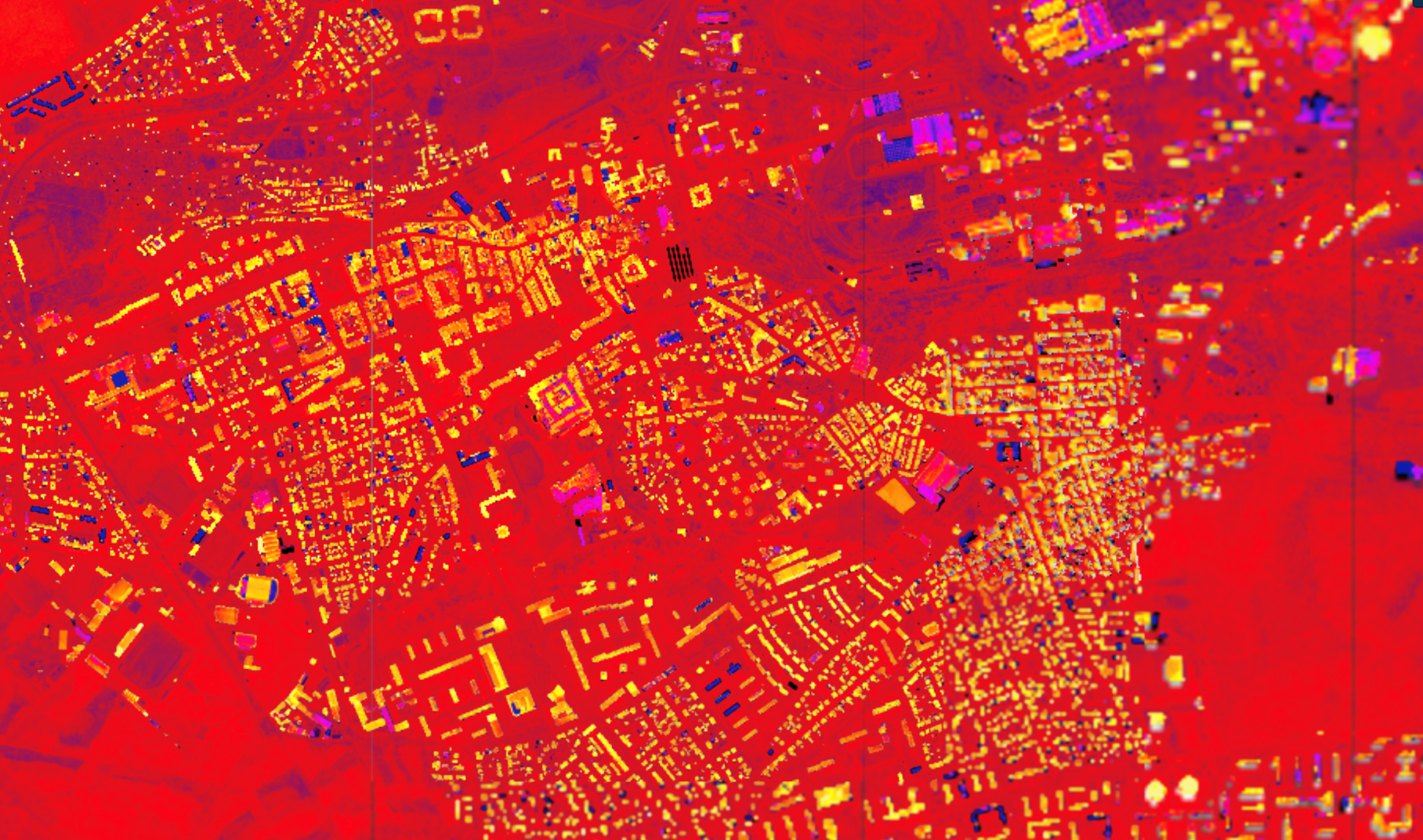
Náklady na teplo patří nejen u rodinných domů, ale zejména u místních samospráv a firemních budov a areálů k těm největším. Tepelné mosty a s nimi spojené úniky tepla mohou zvýšit náklady na provoz o desítky tisíc korun. Informace o tom, kudy z budovy teplo uniká, může majitelům a správcům nemovitostí dodat analýza leteckých snímků. V loňském roce si podobnou nechalo zpracovat […]
The post Místa s úniky tepla odhalí analýza leteckých snímků. Problémy nejčastěji dělají stará okna, ale i špatně zapojená fotovoltaika (TZ) appeared first on GISportal.cz.
20210210 - volné místo - Odborný referent v OPV k nemovitostem KP Teplice na KÚ pro Ústecký kraj
10.2.2021 8:05 ČÚZK - předpisy a opatření Katastrální úřad pro Ústecký kraj - Katastrální pracoviště Teplice zveřejnil novou aktualitu: Nabídka volného místa - Odborný referent v oddělení právních vztahů k nemovitostem Katastrálního pracoviště Teplice na Katastrálním úřadu pro Ústecký kraj20210210 - volné místo - Odborný referent v OPV k nemovitostem KP Teplice na KÚ pro Ústecký kraj
10.2.2021 8:05 ČÚZK /Urady/Katastralni-urady/Katastralni-urady/Katastralni-urad-pro-Ustecky-kraj/Katastralni-pracoviste/KP-Teplice/O-uradu/Aktuality/20210210-volne-misto-Odborny-referent-v OPV-k20210210 - volné místo - Odborný referent v OPV k nemovitostem KP Teplice na KÚ pro Ústecký kraj
10.2.2021 8:03 ČÚZK - předpisy a opatření Katastrální úřad pro Ústecký kraj - Katastrální pracoviště Teplice zveřejnil novou aktualitu: Nabídka volného místa - Odborný referent v oddělení právních vztahů k nemovitostem Katastrálního pracoviště Teplice na Katastrálním úřadu pro Ústecký kraj20210210 - volné místo - Odborný referent v OPV k nemovitostem KP Teplice na KÚ pro Ústecký kraj
10.2.2021 8:03 ČÚZK /Urady/Katastralni-urady/Katastralni-urady/Katastralni-urad-pro-Ustecky-kraj/O-uradu/Aktuality/20210210-volne-misto-Odborny-referent-v OPV-kOdborný referent v oddělení právních vztahů k nemovitostem Katastrálního pracoviště Teplice na Katas
10.2.2021 7:58 ČÚZK /Urady/Katastralni-urady/Katastralni-urady/Katastralni-urad-pro-Ustecky-kraj/Volna-mista/DMS/Odborny-referent-v oddeleni-pravnich-vztahu-k nemoOdborný referent v oddělení právních vztahů k nemovitostem Katastrálního pracoviště Teplice na Katas
10.2.2021 7:58 ČÚZK - předpisy a opatření Katastrální úřad pro Ústecký kraj Katastrální pracoviště Teplicevypisuje výběrové řízení na místo
Odborný referent v oddělení právních vztahů k nemovitostem Katastrálního pracoviště Teplice na Katastrálním úřadu pro Ústecký kraj
Odborný referent v oddělení právních vztahů k nemovitostem Katastrálního pracoviště Teplice na Katas
10.2.2021 7:58 ČÚZK - volná místa Katastrální úřad pro Ústecký kraj Katastrální pracoviště Teplice vypisuje výběrové řízení na místo Odborný referent v oddělení právních vztahů k nemovitostem Katastrálního pracoviště Teplice na KatasSwift Navigation Raises $50 Million Series C Round to Accelerate Consumer Adoption of Automotive Safety and Precise Navigation Applications Across the Globe
9.2.2021 20:36 GISCafe.com Webcasts-Webinars SAN FRANCISCO, Feb. 09, 2021 (GLOBE NEWSWIRE) -- Swift Navigation, a San Francisco-based tech firm redefining GNSS (Global Navigation Satellite …Aquiline Drones Begins Production of "Made in America" Drones
9.2.2021 18:01 GISCafe.com Webcasts-Webinars Aquiline Drones is launching the exciting production of Made-in-America commercial drones. The new manufacturing facility in Hartford, CT positions …Think Power Solutions Introduces Storm Assessment Service
9.2.2021 15:38 GISCafe.com Webcasts-Webinars Think Power Solutions new service provides damage assessments, restoration requirements and construction oversight in its new offeringPLANO, Texas, …
Kratos Defense Robotic Self-Driving Unmanned Truck Customer Portfolio Expands as Deployments are Increasing in the United States and Worldwide
9.2.2021 15:37 GISCafe.com Webcasts-Webinars SAN DIEGO, Feb. 09, 2021 (GLOBE NEWSWIRE) -- Kratos Defense & Security Solutions, Inc. (Nasdaq: KTOS), a leading National Security Solutions …Mortgage Delinquency in November Reaches the Lowest Level Since March, CoreLogic Reports
9.2.2021 15:37 GISCafe.com Webcasts-Webinars New delinquencies fall below pre-pandemic levels and serious delinquencies are the lowest since June 2020IRVINE, Calif. — (BUSINESS WIRE) …
U.S. Drone Maker Skydio Selected for Final Integration in the U.S. Army’s Short Range Reconnaissance Program
9.2.2021 15:37 GISCafe.com Webcasts-Webinars REDWOOD CITY, Calif. — (BUSINESS WIRE) — February 9, 2021 —Skydio, the leading U.S. drone manufacturer and world leader in …
PrecisionHawk Forms Alliance With American Tower to Set Industry Standard for Cell Tower Inspections
9.2.2021 15:37 GISCafe.com Webcasts-Webinars Multi-year Alliance Combines PrecisionHawk’s Autonomous Drone Flight and AI-Powered Analytics Software to Improve the Safety, Efficiency, and …DroneDeploy Joins Forces with Corteva Agriscience to Bring Scalable, Best-In-Class In-Field Analytics to Farmers Across the Globe
9.2.2021 15:37 GISCafe.com Webcasts-Webinars SAN FRANCISCO, Feb. 09, 2021 (GLOBE NEWSWIRE) -- Today, leading enterprise drone data platform DroneDeploy announces a collaboration with one of …Teledyne Imaging Begins a New Era in Large Area CMOS Imaging
9.2.2021 15:37 GISCafe.com Webcasts-Webinars WATERLOO, Ontario, Feb. 09, 2021 (GLOBE NEWSWIRE) -- Teledyne Imaging, part of Teledyne Technologies [NYSE: TDY], is proud to introduce LACera™, …NV5 Geospatial Unveils INSITE, a Cloud-based Geospatial Data Management Platform
9.2.2021 15:37 GISCafe.com Webcasts-Webinars Powerful, comprehensive solution improves efficiency, reduces costs and increases visibility into geospatial data - from acquisition to …MAXST officially Launched Spatial AR Platform Technology
9.2.2021 15:37 GISCafe.com Webcasts-Webinars SEOUL, South Korea, Feb. 9, 2021 — (PRNewswire) — On February 9th 2021, MAXST launched an official website of 'MAXST VPS' …Spustili jsme nové webové stránky ortofotmapa.cz
9.2.2021 14:17 Hrdlička Renovovali jsme stránky, které jsou zaměřeny na tvorbu ortofotomap pomocí leteckého snímkování.Celofiremní školení proběhlo letos distančně
9.2.2021 14:09 Hrdlička S ohledem na vládní nařízení související s pandemií Covid-19 se uskutečnilo celofiremní školení on-line.Celofiremní školení proběhlo letos distanční formou
9.2.2021 14:08 Hrdlička S ohledem na vládní nařízení související s pandemií Covid-19 se uskutečnilo celofiremní školení on-line.APG se zabývá pozemkovými úpravami
9.2.2021 14:01 Hrdlička Všechna voda z České republiky odtéká. Jak ji zadržet v naší krajině a udržet tak přírodu živou?ArcGIS API for JavaScript 4.18
9.2.2021 10:10 blog ARCDATA Koncem roku 2020 vyšla nová verze ArcGIS API for JavaScript, knihovny pro psaní vlastních webových aplikací nad službami ArcGIS. Verze 4.18 přináší mnoho novinek, pojďme si o některých něco říct.vystaveno oznámení o vyhlášení výběrového řízení
9.2.2021 9:28 ČÚZK - předpisy a opatření Katastrální úřad pro Jihočeský kraj - Katastrální pracoviště Písek zveřejnil novou aktualitu: Bylo vystaveno oznámení o vyhlášení výběrového řízení na služební místo rada/odborný rada – rozhodování o povolení vkladu v oddělení právních vztahů k nemovitostem.vystaveno oznámení o vyhlášení výběrového řízení
9.2.2021 9:28 ČÚZK /Urady/Katastralni-urady/Katastralni-urady/Katastralni-urad-pro-Jihocesky-kraj/Katastralni-pracoviste/KP-Pisek/O-uradu/Aktuality/vystaveno-oznameni-o-vyhlaseni-vyberoveho-rizenioznámení o vyhlášení výběrového řízení
9.2.2021 8:58 ČÚZK - předpisy a opatření Katastrální úřad pro Jihočeský kraj - Katastrální pracoviště Písek zveřejnil novou aktualitu: Bylo vystaveno oznámení o vyhlášení výběrového řízení na služební místo rada/odborný rada – rozhodování o povolení vkladu v oddělení právních vztahů k nemovitostem viz. "Volná místa".oznámení o vyhlášení výběrového řízení
9.2.2021 8:58 ČÚZK /Urady/Katastralni-urady/Katastralni-urady/Katastralni-urad-pro-Jihocesky-kraj/Katastralni-pracoviste/KP-Pisek/O-uradu/Aktuality/oznameni-o-vyhlaseni-vyberoveho-rizeniGISáček 2021 (pozvánka)
9.2.2021 8:45 GISportal.cz
19.3.2021 se uskuteční další ročník studentské soutěžní konference GISáček. Na posluchače čeká přehled nejlepších bakalářských a diplomových prací z vysokých škol v České a Slovenské republice. Společným tématem bude geoinformatika a to v jakékoliv podobě. Prezentované práce budou zaměřeny například na vývoj aplikací, analytické zpracování geodat, či na jejich prezentaci. Příspěvky budou přijímány do 5.3.2021. […]
The post GISáček 2021 (pozvánka) appeared first on GISportal.cz.
Satlab Geosolutions Established a Strategic Partnership Alliance with Aplitop
9.2.2021 4:41 Satlab GeosolutionsSweden, 9 October 2018 Satlab Geosolutions, a leading surveying equipment manufacturer, has partnered with Aplitop, a software company specialising in the development of surveying and civil engineering, to provide a wider range of software and solutions for our professional users from the office to the field. “This partnership is an exciting project that will allow […]
The post Satlab Geosolutions Established a Strategic Partnership Alliance with Aplitop appeared first on SatLab – Global Satellite Positioning Solutions.
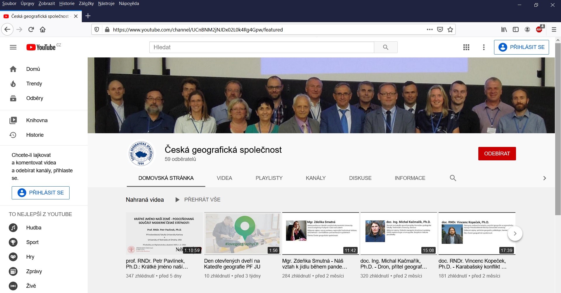
Nový YouTube kanál ČGS
9.2.2021 0:00 Geografický ústav MUPředstavujeme vám nový YouTube kanál České geografické společnosti.
Nový YouTube kanál ČGS
9.2.2021 0:00 Geografický ústav MUPředstavujeme vám nový YouTube kanál České geografické společnosti.
Sagetech Avionics Receives DoD AIMS Certification for Mode 5 Micro IFF Transponder for Drones
8.2.2021 23:47 GISCafe.com Webcasts-Webinars The MX12B micro transponder, the world's first to be certified by DoD AIMS to 17-1000 Mark XIIB, significantly expands the ability for NATO and …Teal Drones and Decathlon Capital Partners Agree on Multi-Million-Dollar Funding Deal to Fuel Growth, R&D
8.2.2021 19:32 GISCafe.com Webcasts-Webinars Investment will fuel new innovation in U.S.-made, military-grade drone technologySALT LAKE CITY, Feb. 8, 2021 — (PRNewswire) —
SALT …
Exprodat Enhances Access to Planet Imagery for Esri Users
8.2.2021 17:25 GISCafe.com Webcasts-Webinars Planet, a leading provider of satellite imagery and geospatial solutions, is committed to delivering the necessary tools and software needed for …Matterport, The Spatial Data Company Leading The Digital Transformation Of The Built World, Announces Proposed Business Combination With Gores Holdings VI
8.2.2021 16:06 GISCafe.com Webcasts-Webinars - From offline to online, Matterport's market leading technology platform turns buildings into data to deliver unparalleled property insights and …Sky-Futures Partners With SeekOps to Support Global Expansion of Drone-based Fugitive Emissions Detection Service
8.2.2021 16:06 GISCafe.com Webcasts-Webinars AUSTIN, Texas — (BUSINESS WIRE) — February 8, 2021 —Sky-Futures, an ICR company, one of the world’s leading drone inspection …
Zveřejnění obsahu informací poskytnutých na žádost dle zákona č. 106/1999 Sb. za rok 2021
8.2.2021 15:59 ČÚZK /Urady/Katastralni-urady/Katastralni-urady/Katastralni-urad-pro-Ustecky-kraj/Casto-hledane-informace/Poskytovani-informaci-106-1999-Sb/Zverejneni-obsahu-informaci-poskytnutych-na-za-(1)/Zverejneni-obsahu-informaci-poskytnutych-na-za-(3)Zveřejnění obsahu informací poskytnutých na žádost dle zákona č. 106/1999 Sb. za rok 2021
8.2.2021 15:59 ČÚZK - předpisy a opatření Katastrální úřad pro Ústecký krajzveřejňuje obsah informace poskytnutých na žádost dle zákona č. 106/1999 Sb. za rok
2021
Sentinel-6 passes in-orbit tests with flying colours
8.2.2021 15:00 ESA Observing the EarthIn November 2020, the Copernicus Sentinel-6 Michael Freilich satellite was launched into orbit from the Vandenberg Air Force Base in California, US. Now, months later, the satellite has successfully passed what is known as the ‘in-orbit verification phase’, where its equipment is switched on and the instruments’ performance is checked.
rada/odborný rada – rozhodování o povolení vkladu v oddělení právních vztahů k nemovitostem Katastrá
8.2.2021 14:56 ČÚZK /Urady/Katastralni-urady/Katastralni-urady/Katastralni-urad-pro-Jihocesky-kraj/Uredni-deska/Oznameni-a-jina-uredni-sdeleni/Volna-mista/DMS/rada-odborny-rada-–-rozhodovani-o-povoleni-vkladurada/odborný rada – rozhodování o povolení vkladu v oddělení právních vztahů k nemovitostem Katastrá
8.2.2021 14:56 ČÚZK - volná místa Katastrální úřad pro Jihočeský kraj Katastrální pracoviště Písek vypisuje výběrové řízení na místo rada/odborný rada – rozhodování o povolení vkladu v oddělení právních vztahů k nemovitostem Katastrárada/odborný rada – rozhodování o povolení vkladu v oddělení právních vztahů k nemovitostem Katastrá
8.2.2021 14:56 ČÚZK - předpisy a opatření Katastrální úřad pro Jihočeský kraj Katastrální pracoviště Písekvypisuje výběrové řízení na místo
rada/odborný rada – rozhodování o povolení vkladu v oddělení právních vztahů k nemovitostem Katastrálního pracoviště Písek (ID SM 30000223/30003847)
Změny názvu katastrálních území
8.2.2021 14:51 ČÚZK - předpisy a opatření Český úřad zeměměřický a katastrální zveřejnil novou aktualitu: Zveřejněn aktualizovaný seznam změn názvů katastrálních území.Změny názvu katastrálních území
8.2.2021 14:51 ČÚZK - aktuality v resortu Zveřejněn aktualizovaný seznam změn názvů katastrálních území.Změny názvu katastrálních území
8.2.2021 14:51 ČÚZK /Aktuality-resort/2021/Zmeny-nazvu-katastralnich-uzemiVideo: Proč jsou pozemkové úpravy důležité pro krajinu
8.2.2021 12:45 GeoBusinessNové video od Asociace podnikatelů v geomatice propaguje důležitost pozemkových úprav pro krajinu. Co můžete udělat dál? Podívat se na stránky Asociace podnikatelů v geomatice a stát se členem Přečíst si koncepci pozemkových úprav na období 2021 – 2025 Jaké bylo financování pozemkových úprav v roce 2020
The post Video: Proč jsou pozemkové úpravy důležité pro krajinu appeared first on GeoBusiness.
Galileo delivers accuracy; drones deliver solutions
8.2.2021 12:01 European GNSS Agency
GNSS is a key enabler for drones and Unmanned Aerial Vehicles (UAVs), ensuring safety of navigation and providing increased reliability for both consumer and commercial applications. Therefore, it should come as no surprise that, over the past decade, drones have become a significant GNSS segment, overtaking mature segments such as maritime, aviation and agriculture in terms of shipments, according to the GNSS Market Report.
At the same time as we have seen this growth in drone traffic, with UAVs used in more and more application areas and a steadily growing user base, new regulatory measures have been put in place to harmonise the European drone market and guarantee the highest level of safety.
In line with these market trends and new regulations and in support of EU priorities, the GSA defined several innovation areas in the MyGalileoDrone and MyGalileoSolution competitions - such as parcel delivery, emergency and crisis management, infrastructure inspection, leisure etc. - with the aim of challenging contestants to design, develop, test and deliver drone-based applications for commercial launch using Galileo-enabled receivers.
Critical precision
It is difficult to understate the importance of the precision provided by Galileo for drone-enabled services, especially if it is not possible to ensure line-of-sight or human supervision at all times. The improved integrity and high accuracy of Galileo positioning information helps drones to follow their assigned routes closely, especially in urban areas.
Read this: Entrepreneurship Day to showcase the most innovative Galileo-based solutions
“We were delighted to work together with the MyGalileoDrone and MyGalileoSolution competitors, who joined us virtually from across Europe. These teams represent start-ups and SMEs, business and academia alike,” said Katerina Strelcova, GSA Aviation Market Development Innovation Officer. “The contestants showed great creativity in identifying new service areas, achieved technological breakthroughs, and introduced novel business models. The results promise to have a positive societal impact and an excellent commercial value,” she said.
A World of Drones
After rounds of meticulous reviews, expert consultations, and mentoring, the 37 most innovative drone solutions developed during the two competitions will be presented at the “World of Drones” session of the Entrepreneurship Day that will take place 2 March. At this online event, the GSA will showcase the most innovative Galileo-based solutions delivering cutting-edge services across a range of application areas.
Watch this: EGNOS for Drones
Projects from MyGalileoDrone will be presented, along with the AirCoffee, Artificial Intelligence Autonomous VTOL Drone Platform, GALENCODER, SigLoc, TechNovator, Touchdown, and DROCATS projects from MyGalileoSolution.
Make sure to join us and learn how the innovative teams are:
- delivering critical goods on time in remote and densely populated areas;
- helping to find survivors at sea during search and rescue missions;
- guiding boats to their port moorings;
- combining drones with unmanned ground vehicles to assess and maintain road surface markings;
- monitoring pollution, and much more!
Register now to find out which application is deemed most successful by our jury and investors, and is awarded the grand prize. Make sure to follow us on Twitter, LinkedIn, Facebook or Instagram to stay up to date with all the latest news.
Media note: This feature can be republished without charge provided the European GNSS Agency (GSA) is acknowledged as the source at the top or the bottom of the story. You must request permission before you use any of the photographs on the site. If you republish, we would be grateful if you could link back to the GSA website (http://www.gsa.europa.eu).
Připomínky APG k novému stavebnímu zákonu
8.2.2021 9:45 Komora geodetů a kartografů ČR Vzhledem k tomu, že nový stavební zákon bude z velké části prostřednictvím PN přepracován, rozhodlo se vedení APG předložit znovu své připomínky a uplatnit je prostřednictvím PN. Připomínky APG k NSZ jsou předmětem komplexního pozměňovacího návrhu skupiny opozičních poslanců a zároveň připravujeme náš vlastní pozměňovací návrh, který předloží některý z koaličních poslancůHledáme kolegu kartografa / kolegyni katrografku pro naše pracoviště [Katedra aplikované geoinformatiky a kartografie, byTopic]
8.2.2021 9:30 Katedra aplikované geoinformatiky a kartografie Přf UK Kartograf/ka na katedře aplikované geoinformatiky a kartografie PřF UK (plný úvazek)Hledáme kolegu kartografa pro naše pracoviště [Katedra aplikované geoinformatiky a kartografie, byTopic]
8.2.2021 9:30 Katedra aplikované geoinformatiky a kartografie Přf UK Kartograf na katedře aplikované geoinformatiky a kartografie PřF UK (plný úvazek)Hledáme kolegu kartografa / kolegyni katrografku pro naše pracoviště [Katedra aplikované geoinformatiky a kartografie, byTopic]
8.2.2021 9:30 Katedra aplikované geoinformatiky a kartografie Přf UK Kartograf/ka na katedře aplikované geoinformatiky a kartografie PřF UK (plný úvazek). Nástup možný od 1. 6. 202115. Kartografický den Olomouc 2021 bude online
8.2.2021 7:00 Česká asociace pro geoinformace 15. kartografický den Olomouc se letos uskuteční online, již tradičně poslední únorový pátek, tedy 26. února 2021. Tématem jubilejního 15. ročníku je Kartografie a technologie. Celý program proběhne v zajímavém prostředí online platformy Gather Town, která umožní účastníkům přenést se do Olomouce virtuálně v rámci vymodelovaného městečka. Program, formulář kAPGEO - Připomínky APG k novému stavebnímu zákonu
8.2.2021 1:00 Asociace podnikatelů v geomatice Prostřednictvím pozměňovacího návrhu jsme předložili připomínky k NSZ.APGEO - Připomínky APG k novému stavebnímu zákonu
8.2.2021 1:00 Asociace podnikatelů v geomatice Vzhledem k tomu, že nový stavební zákon bude z velké části prostřednictvím PN přepracován, rozhodlo se vedení APG ...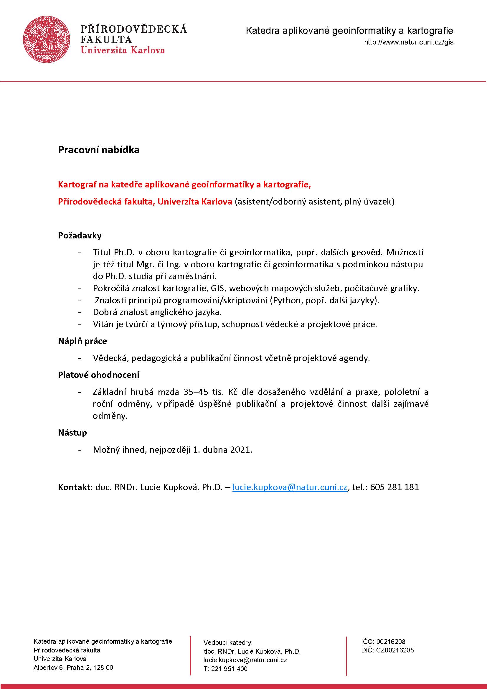
CAD & PDF = TurboCAD Designer + TurboPDF v akční ceně
7.2.2021 13:55 ŠPINAR - softwareVážení zákazníci,
máme pro Vás připravené programy TurboCAD Deluxe 27 CZ + TurboPDF CZ, které spojují CAD nástroje pro kreslení ve 2D / 3D prostoru včetně fotorealistických výstupů s editorem a převodníkem PDF dokumentů v akční ceně do 04. 02. 2021.
The post CAD & PDF = TurboCAD Designer + TurboPDF v akční ceně appeared first on ŠPINAR – software.
Lokalizace ArcGIS Pro 2.7
5.2.2021 15:26 ARCDATAČeská lokalizace ArcGIS Pro 2.7 je k dispozici ke stažení na portálu My Esri.
Pokud ArcGIS Pro 2.7 již používáte v angličtině, můžete si na My Esri stáhnout jen lokalizační balíček. (Moje organizace – Stahování – ArcGIS Pro – Zobrazit stahování – sekce jazykových balíčků je na konci seznamu.)
"GISCafé Voice Industry Predictions for 2021 – Part 3" by Susan Smith
5.2.2021 13:53 GISCafe.com Webcasts-WebinarsGISáček 2021
5.2.2021 13:41 Katedra geoinformatiky UP OlomoucStudentská konference GISáček 2021 (http://gis.vsb.cz/gisostrava/cz/gisacek.php), letos opět proběhne online formou. Registrace abstraktů je do 5.3 možná na uvedené stránce. Studentská konference se koná třetí den naší větší Konference GIS Ostrava 2021. A prezentující studenti mají volný přístup i na tuto konferenci. Konference bude opět soutěžní, takže studenti mohou vyhrát i nějaké ocenění (pro představu viz loňské výhry […]
The post GISáček 2021 appeared first on Katedra geoinformatiky.
Ředitel/ka Ekonomického odboru
5.2.2021 12:00 ČÚZK - předpisy a opatření Zeměměřický úřadvypisuje výběrové řízení na místo
Ředitel/ka Ekonomického odboru
Ředitel/ka Ekonomického odboru
5.2.2021 12:00 ČÚZK - volná místa Zeměměřický úřad vypisuje výběrové řízení na místo Ředitel/ka Ekonomického odboruŘeditel/ka Ekonomického odboru
5.2.2021 12:00 Zeměměřický úřad Zeměměřický úřadvypisuje výběrové řízení na místo
Ředitel/ka Ekonomického odboru
Ředitel/ka Ekonomického odboru
5.2.2021 12:00 ČÚZK /Urady/Zememericky-urad/Uredni-deska/Oznameni-a-jina-uredni-sdeleni/Volna-mista/Reditel-ka-Ekonomickeho-odboru-(3)ČÚZK v pondělí 8.2.20
5.2.2021 11:02 GEUSware ČÚZK v pondělí 8.2.2021 od 20:00 do cca 23:00 zcela přeruší provoz Dálkového přístupu (DP) i Webových služeb dálkového přístupu (WSDP). Z tohoto důvodu budou v GEUSu nefunkční Podklady měření a Odesílání GP.Earth from Space: Japan in bloom
5.2.2021 10:00 ESA Observing the Earth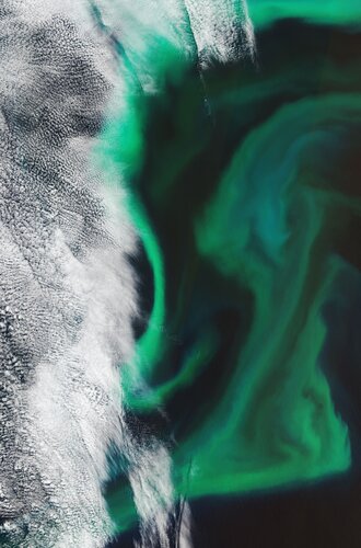
The Copernicus Sentinel-2 mission takes us over the algal blooms swirling around the Pacific Ocean, just off the coast of Japan.
Earth from Space: Japan in bloom
5.2.2021 10:00 ESA Observing the Earth
The Copernicus Sentinel-2 mission takes us over the algal blooms swirling around the Pacific Ocean, just off the coast of Japan.
Rada/odborný rada v oddělení obnovy a revize KN na Katastrálním pracovišti Brno - venkov
5.2.2021 9:31 ČÚZK - volná místa Katastrální úřad pro Jihomoravský kraj Katastrální pracoviště Brno-venkov vypisuje výběrové řízení na místo Rada/odborný rada v oddělení obnovy a revize KN na Katastrálním pracovišti Brno - venkovRada/odborný rada v oddělení obnovy a revize KN na Katastrálním pracovišti Brno - venkov
5.2.2021 9:31 ČÚZK /Urady/Katastralni-urady/Katastralni-urady/Katastralni-urad-pro-Jihomoravsky-kraj/Uredni-deska/Oznameni-a-jina-uredni-sdeleni/Volna-mista/DMS/Rada-odborny-rada-v-oddeleni-obnovy-a-revize-KN-naRada/odborný rada v oddělení obnovy a revize KN na Katastrálním pracovišti Brno - venkov
5.2.2021 9:31 ČÚZK - předpisy a opatření Katastrální úřad pro Jihomoravský kraj Katastrální pracoviště Brno-venkovvypisuje výběrové řízení na místo
Rada/odborný rada v oddělení obnovy a revize KN na Katastrálním pracovišti Brno - venkov
Bluesky Takes to the Air to Create First 3D Map of Northern Ireland’s Coastline
5.2.2021 9:00 GISCafe.com Webcasts-Webinars Leicestershire, UK, 03 February 2021 - Bluesky International will use aircraft mounted LiDAR sensors laser scanners to create a highly detailed 3D …Defense Metals Receives Wicheeda REE Property LiDaR Survey Results
5.2.2021 9:00 GISCafe.com Webcasts-Webinars VANCOUVER, BC, Feb. 1, 2021 — (PRNewswire) — Defense Metals Corp. ("Defense Metals") (TSX-V: DEFN) (OTCQB: DFMTF) (FSE: 35D) is pleased …Geoportál pro pozemkové úpravy poběží od poloviny roku 2021
5.2.2021 6:34 GeoBusinessStátní pozemkový úřad vydal koncepci pozemkových úprav na období 2021 – 2025. Plánované náklady na činnosti v pozemkových úpravách (návrhy, realizace PSZ a další související činnosti) pro období 2021 – 2025 jsou ve výši 13 miliard korun. V dokumentu je rovněž uvedeno, že od poloviny roku 2021 bude v provozu nový Geoportál SPÚ, který umožní […]
The post Geoportál pro pozemkové úpravy poběží od poloviny roku 2021 appeared first on GeoBusiness.
K dispozici je servicepack SP2
5.2.2021 0:00 SolidVision K dispozici je servicepack SP2 pro SOLIDWORKS 2021. Uživatelé s aktivní předplacenou údržbou si mohou nejaktuálnější servicepack stáhnout na Zákaznickém portále SOLIDWORKS.
K dispozici je servicepack SP2
5.2.2021 0:00 SolidVision K dispozici je servicepack SP2 pro SOLIDWORKS 2021. Uživatelé s aktivní předplacenou údržbou si mohou nejaktuálnější servicepack stáhnout na Zákaznickém portále SOLIDWORKS.Technologie v kartografii popíší šéf MapTileru i veterán herního průmyslu. Letošní Kartografický den 2021 se bude konat až do půlnoci
4.2.2021 22:53 GeoBusinessTématem jubilejního patnáctého ročníku jsou technologie v kartografii, protože výrazně ovlivňují současnou podobu kartografie. Jejich rychlý vývoj je však obtížné sledovat, když zaměření jednotlivých odborníků je naopak čím dál úžeji profilované. Vybraní přednášející proto přinesou informace o aktuálním vývoji v různých oblastech tak, aby všichni účastníci získali představu o tom, jak v současné době technologie […]
The post Technologie v kartografii popíší šéf MapTileru i veterán herního průmyslu. Letošní Kartografický den 2021 se bude konat až do půlnoci appeared first on GeoBusiness.
Technologie v kartografii popíší šéf Map Tileru i veterán herního průmyslu. Letošní Kartografický den 2021 se bude konat až do půlnoci
4.2.2021 22:53 GeoBusinessTématem jubilejního patnáctého ročníku jsou technologie v kartografii, protože výrazně ovlivňují současnou podobu kartografie. Jejich rychlý vývoj je však obtížné sledovat, když zaměření jednotlivých odborníků je naopak čím dál úžeji profilované. Vybraní přednášející proto přinesou informace o aktuálním vývoji v různých oblastech tak, aby všichni účastníci získali představu o tom, jak v současné době technologie […]
The post Technologie v kartografii popíší šéf Map Tileru i veterán herního průmyslu. Letošní Kartografický den 2021 se bude konat až do půlnoci appeared first on GeoBusiness.
Webová kartografie. Kniha od Rostislava Néteka
4.2.2021 21:54 GeoBusinessRostislav Nétek, odborný asistent na katedře geoinformatiky Přírodovědecké fakulty Univerzity Palackého v Olomouci, vydal knihu s názvem Webová kartografie. Kartografie je samozřejmě obor s dlouhou historií, avšak v posledních desetiletích došlo k velkým změnám, zejména v souvislosti s nástupem používání internetu a webu. V nové publikaci autor popisuje odlišnosti kartografie na webu a snaží se […]
The post Webová kartografie. Kniha od Rostislava Néteka appeared first on GeoBusiness.
Nové číslo Zpravodaje ČKS (1/2021)
4.2.2021 20:50 Česká kartografická společnost Nedlouho poté, co vyšel poslední zpravodaj loňského roku přinášíme první Zpravodaj České kartografické společnosti v roce 2021. Prolistovat si jej můžete níže i online. Přejeme příjemné čtení!Jaké bylo financování pozemkových úprav v roce 2020
4.2.2021 19:59 ZeměměřičStátní pozemkový úřad vyčerpal v roce 2020 na pozemkové úpravy finanční prostředky ve výši 700 milionů korun ze Všeobecné pokladní správy, 610 milionů korun z rozpočtu MZe, 48 milionů korun z rozpočtu úřadu, přibližně 134 milionů korun na předfinancování projektů z Programu rozvoje venkova a 3,5 milionů korun z Operačního programu Životní prostředí (OPŽP). „Celkový objem finančních prostředků na pozemkové úpravy […]
The post Jaké bylo financování pozemkových úprav v roce 2020 appeared first on Zeměměřič.
BIM a pozemkové úpravy
4.2.2021 19:31 ZeměměřičV rámci příprav digitalizace stavebního řízení vzniká nový zákon o předávání stavební dokumentace v digitální podobě. Státní pozemkový úřad má koncepčně pečovat o krajinu i racionálně a transparentně nakládat se státní zemědělskou půdou. Státní pozemkový úřad vznikl k 1. lednu 2013 na základě zákona č. 503/2012 Sb., o Státním pozemkovém úřadu. Je příslušný hospodařit s nemovitostmi, které byly ve správě Pozemkového fondu ČR, a rovněž se […]
The post BIM a pozemkové úpravy appeared first on Zeměměřič.