


![]()

zprávy
zdroje zpráv:It is time for your project to shine: join us at Infoshare 2020
21.8.2020 10:59 European GNSS Agency
Interested in presenting your solution at Infoshare? Then read on! The European GNSS Agency (GSA) is looking for innovative solutions to showcase at the virtual Galileo stand during Infoshare event taking place 23 – 30 September 2020. Infoshare is the biggest Tech Conference in Central and Eastern Europe. In 2019 it gathered over 6000 participants and 700+ start-ups, speakers and investors. It’s a place to share ideas and passions but also to boost start-ups and investments. In 2020, under the changed circumstances, Infoshare will continue to be a place to meet like-minded developers and experts and make new contacts from the industry in a digital format.
Infoshare 2020 edition streamed from the city of Gdańsk will be presenting a brand-new agenda spread in six days and seven stages, and covering diverse topics such as developers’ trends, artificial intelligence, machine learning, data science, big data, cybersecurity or blockchain. With nearly 70 partners, more than 20 media partners, 60+ investor companies and with a programme featuring leading visionaries and investors, the conference is a not-to-be-missed opportunity to present and promote innovative ideas, technologies and applications and bring them to the attention of business leaders, innovators and key decision-makers.
With the goal of exploring the hottest trends influencing the digital industry, Infoshare is an ideal platform to showcase and promote innovative EGNSS-based solutions and applications.
Read this: MyGalileoDrone contest open for submissions!
“Infoshare, with its new digital format, is showing how digital solutions can enhance business and networking opportunities with a global virtual exhibition, and a stage and an audience that knows no limits. This is a great opportunity for innovative companies to present their EGNSS-based solutions and bring their applications to the attention of a large audience of peers, investors and the public at large. If you have an EGNSS-based solution with the potential to improve the lives of European citizens, then we would like to hear from you,” said GSA Head of Market Development Fiammetta Diani.
Expression of Interest
With this in mind, ahead of the coming Infoshare, GSA is launching a call for expressions of interest among its Horizon 2020, Fundamental Elements, Galileo competitions partners and other EU companies. The idea is to provide a space at the GSA virtual stand to showcase our partners’ Galileo-enabled mobile solutions. If you have an EGNSS-based solution or product that you would like to showcase at Infoshare, please submit your application to prizes@gsa.europa.eu by 7th of September 2020. Put “Interested in showcasing our project at Infoshare 2020” in the subject line of your email. For more information on how to apply please read the Rules and Conditions.
This is an unmissable opportunity to present your solutions to potential investors, tech companies and user communities. Join us online where innovation is celebrated, connections are made, insights are gained, products are launched and business gets done!
EGNSS-based innovation
By matching ideas with opportunities and talent with resources, Infoshare helps support the GSA in its mission of linking space to user needs. Representative from the Agency will speak at the virtual stages and present updates on Galileo, showcase resources and opportunities for innovators, share market insights and trends, and expand on how GNSS can be leveraged to boost innovation among industry, app developers and service providers.
And this: Ubiscale: low-power GNSS processing for tracking devices
Places at the virtual stand will be limited, so get in touch with us as soon as possible to take advantage of this exciting opportunity!
Media note: This feature can be republished without charge provided the European GNSS Agency (GSA) is acknowledged as the source at the top or the bottom of the story. You must request permission before you use any of the photographs on the site. If you republish, we would be grateful if you could link back to the GSA website (http://www.gsa.europa.eu).
It is time for your project to shine: join us at Infoshare 2020
21.8.2020 10:59 European GNSS AgencyInterested in presenting your solution at Infoshare? Then read on! The European GNSS Agency (GSA) is looking for innovative solutions to showcase at the virtual Galileo stand during Infoshare event taking place 23 – 30 September 2020. Infoshare is the biggest Tech Conference in Central and Eastern Europe. In 2019 it gathered over 6000 participants and 700+ start-ups, speakers and investors. It’s a place to share ideas and passions but also to boost start-ups and investments. In 2020, under the changed circumstances, Infoshare will continue to be a place to meet like-minded developers and experts and make new contacts from the industry in a digital format.
Infoshare 2020 edition streamed from the city of Gdańsk will be presenting a brand-new agenda spread in six days and seven stages, and covering diverse topics such as developers’ trends, artificial intelligence, machine learning, data science, big data, cybersecurity or blockchain. With nearly 70 partners, more than 20 media partners, 60+ investor companies and with a programme featuring leading visionaries and investors, the conference is a not-to-be-missed opportunity to present and promote innovative ideas, technologies and applications and bring them to the attention of business leaders, innovators and key decision-makers.
With the goal of exploring the hottest trends influencing the digital industry, Infoshare is an ideal platform to showcase and promote innovative EGNSS-based solutions and applications.
Read this: MyGalileoDrone contest open for submissions!
“Infoshare, with its new digital format, is showing how digital solutions can enhance business and networking opportunities with a global virtual exhibition, and a stage and an audience that knows no limits. This is a great opportunity for innovative companies to present their EGNSS-based solutions and bring their applications to the attention of a large audience of peers, investors and the public at large. If you have an EGNSS-based solution with the potential to improve the lives of European citizens, then we would like to hear from you,” said GSA Head of Market Development Fiammetta Diani.
Call for applications
With this in mind, ahead of the coming Infoshare, GSA is launching a call for applications among its Horizon 2020, Fundamental Elements, Galileo competitions partners and innovators and enterprenerus across Europe . The idea is to provide a space at the GSA virtual stand to showcase our partners’ Galileo-enabled mobile solutions. If you have an EGNSS-based solution or product that you would like to showcase at Infoshare, please submit your application to prizes@gsa.europa.eu by 7th of September 2020. Put “Interested in showcasing our project at Infoshare 2020” in the subject line of your email. For more information on how to apply please read the Rules and Conditions.
This is an unmissable opportunity to present your solutions to potential investors, tech companies and user communities. Join us online where innovation is celebrated, connections are made, insights are gained, products are launched and business gets done!
EGNSS-based innovation
By matching ideas with opportunities and talent with resources, Infoshare helps support the GSA in its mission of linking space to user needs. Representative from the Agency will speak at the virtual stages and present updates on Galileo, showcase resources and opportunities for innovators, share market insights and trends, and expand on how GNSS can be leveraged to boost innovation among industry, app developers and service providers.
And this: Ubiscale: low-power GNSS processing for tracking devices
Places at the virtual stand will be limited, so get in touch with us as soon as possible to take advantage of this exciting opportunity!
Media note: This feature can be republished without charge provided the European GNSS Agency (GSA) is acknowledged as the source at the top or the bottom of the story. You must request permission before you use any of the photographs on the site. If you republish, we would be grateful if you could link back to the GSA website (http://www.gsa.europa.eu).
It is time for your project to shine: join us at Infoshare 2020
21.8.2020 10:59 European GNSS AgencyInterested in presenting your solution at Infoshare? Then read on! The European GNSS Agency (GSA) is looking for innovative solutions to showcase at the virtual Galileo stand during Infoshare event taking place 23 – 30 September 2020. Infoshare is the biggest Tech Conference in Central and Eastern Europe. In 2019 it gathered over 6000 participants and 700+ start-ups, speakers and investors. It’s a place to share ideas and passions but also to boost start-ups and investments. In 2020, under the changed circumstances, Infoshare will continue to be a place to meet like-minded developers and experts and make new contacts from the industry in a digital format.
Infoshare 2020 edition streamed from the city of Gdańsk will be presenting a brand-new agenda spread in six days and seven stages, and covering diverse topics such as developers’ trends, artificial intelligence, machine learning, data science, big data, cybersecurity or blockchain. With nearly 70 partners, more than 20 media partners, 60+ investor companies and with a programme featuring leading visionaries and investors, the conference is a not-to-be-missed opportunity to present and promote innovative ideas, technologies and applications and bring them to the attention of business leaders, innovators and key decision-makers.
With the goal of exploring the hottest trends influencing the digital industry, Infoshare is an ideal platform to showcase and promote innovative EGNSS-based solutions and applications.
Read this: MyGalileoDrone contest open for submissions!
“Infoshare, with its new digital format, is showing how digital solutions can enhance business and networking opportunities with a global virtual exhibition, and a stage and an audience that knows no limits. This is a great opportunity for innovative companies to present their EGNSS-based solutions and bring their applications to the attention of a large audience of peers, investors and the public at large. If you have an EGNSS-based solution with the potential to improve the lives of European citizens, then we would like to hear from you,” said GSA Head of Market Development Fiammetta Diani.
Expression of Interest
With this in mind, ahead of the coming Infoshare, GSA is launching a call for expressions of interest among its Horizon 2020, Fundamental Elements, Galileo competitions partners and other EU companies. The idea is to provide a space at the GSA virtual stand to showcase our partners’ Galileo-enabled mobile solutions. If you have an EGNSS-based solution or product that you would like to showcase at Infoshare, please submit your application to prizes@gsa.europa.eu by 7th of September 2020. Put “Interested in showcasing our project at Infoshare 2020” in the subject line of your email. For more information on how to apply please read the Rules and Conditions.
This is an unmissable opportunity to present your solutions to potential investors, tech companies and user communities. Join us online where innovation is celebrated, connections are made, insights are gained, products are launched and business gets done!
EGNSS-based innovation
By matching ideas with opportunities and talent with resources, Infoshare helps support the GSA in its mission of linking space to user needs. Representative from the Agency will speak at the virtual stages and present updates on Galileo, showcase resources and opportunities for innovators, share market insights and trends, and expand on how GNSS can be leveraged to boost innovation among industry, app developers and service providers.
And this: Ubiscale: low-power GNSS processing for tracking devices
Places at the virtual stand will be limited, so get in touch with us as soon as possible to take advantage of this exciting opportunity!
Media note: This feature can be republished without charge provided the European GNSS Agency (GSA) is acknowledged as the source at the top or the bottom of the story. You must request permission before you use any of the photographs on the site. If you republish, we would be grateful if you could link back to the GSA website (http://www.gsa.europa.eu).
INSPIRE téma Parcely (CP)
21.8.2020 2:00 Cenia - Katalog metadat ČR - INSPIRE Data odpovídají směrnici INSPIRE pro téma katastrální parcely (CP). Vychází z katastrální mapy, která je závazným státním mapovým dílem velkého měřítka, obsahuje body polohového bodového pole, polohopis a popis a může mít formu digitální mapy, analogové mapy nebo digitalizované mapy. Data publikovaná v rámci INSPIRE obsahují pouze katastrální území (pro celou Českou Republiku) a parcely a jejich hranice z území, kde je digitální mapa (k 17. 08. 2020 je to 96,93% území České republiky, t.j. 76 447,37km2). Více katastrální zákon 344/1992 SB., katastrální vyhláška č.26/2007 Sb. v platném znění a INSPIRE Data Specification on Cadastral Parcels v 3.0.1. Data ve formátu GML 3.2.1 jsou validní proti schématu XML pro INSPIRE téma Parcely ve verzi 4.0 a proti schématu pro prostorová data ELF ve verzi 1.0.INSPIRE téma Adresy (AD)
21.8.2020 2:00 Cenia - Katalog metadat ČR - INSPIRE Data odpovídají směrnici INSPIRE pro téma adresy (AD). Vychází především z projektu RÚIAN (Registr územní identifikace, adres a nemovitostí), který je součástí základních registrů České Republiky a obsahuje informace o územní identifikaci, adresách a nemovitostech. Data publikovaná v rámci INSPIRE obsahují pouze adresní místa a jejich komponenty, kterými jsou stát, obec, část obce, městský obvod v Praze (MOP), městký obvod/městská část (MO/MČ), ulice a pošta a to na území celé České Republiky. Obsahují rozvněž geometrii, která určuje definiční bod adresního místa. V datové sadě nění uvedeno 1,12%, t.j. 32796 adresních míst (k 17. 08. 2020), protože neobsahují definiční bod, podle kterého by je bylo možné prostorově určit. Více v zákoně č. 111/2009 Sb., o základních registrech a ve vyhlášce č. 359/2011 Sb., o základním registru územní identifikace, adres a nemovitostí v platných zněních a INSPIRE Data Specification on Addresses v 3.0.1 z 26.4.2010. Data ve formátu GML 3.2.1 jsou validní proti schématu XML pro INSPIRE téma Adresy ve verzi 4.0 a proti schématu pro prostorová data ELF ve verzi 1.0.INSPIRE téma Budovy (BU)
21.8.2020 2:00 Cenia - Katalog metadat ČR - INSPIRE Data odpovídají směrnici INSPIRE pro téma budovy (BU). Data pochází částečně z projektu RÚIAN (Registr územní identifikace, adres a nemovitostí), který je součástí základních registrů České Republiky a obsahuje informace o územní identifikaci, adresách a nemovitostech, a částečně z ISKN (Informační systém katastru nemovistostí). Zdrojem informací o budovách v ISKN je objekt Stavba, v RÚIAN je to Stavební objekt. Většina Staveb je zároveň Stavebními objekty, ale jsou případy, kdy tomu tak není. Kromě Budov datová sada obsahuje i části budov, které jsou pro potřeby INSPIRE vyjádřeny vchody z RÚIAN. Vchody obsahují informace o počtu podlaží, technickoekonomických atributech apod. Datová sada pokrývá celé území české republiky. V datové sadě není uvedeno 1,13%, t.j. 48175 budov (k 17. 08. 2020), protože neobsahují definiční bod ani polygon. Více v zákoně č. 111/2009 Sb., o základních registrech, ve vyhlášce č. 359/2011 Sb., o základním registru územní identifikace, adres a nemovitostí v platných zněních, v zákoně 256/2013 Sb., o katastru nemovitostí, v katastrální vyhlášce č. 357/2013 Sb. v platném znění a INSPIRE Data Specification on Buildings v 3.0 z 13.12.2013. Data ve formátu GML 3.2.1 jsou validní proti schématu XML pro INSPIRE téma Budovy ve verzi 4.0 a proti schématu pro prostorová data ELF ve verzi 1.0.Katastrální mapa ve formátech DGN a DXF poskytovaná v e-shopu
21.8.2020 2:00 Cenia - Katalog metadat ČR - INSPIRE Katastrální mapa je závazným státním mapovým dílem velkého měřítka, obsahuje body polohového bodového pole, polohopis a popis. Katastrální mapa ve vektorové podobě je poskytována zdarma ve formátu DGN a DXF a obsahuje prvky Digitální katastrální mapy (DKM) a Katastrální mapy digitalizované (KMD), tedy bodová pole, budovy, další prvky mapy, hranice parcel, katastrální hranice, parcely katastru nemovitostí, prvky orientační mapy a hranice věcného břemene. Z důvodu použití formátu DGN produkt neobsahuje značky na liniích a oblouky jsou nahrazeny lomenými čárami. Katastrální mapa ve vektorové podobě k 17. 08. 2020 pokrývá 96,93% území České republiky, t.j. 76 447,37km2. Více katastrální vyhláška č.357/2013 Sb. v platném znění.INSPIRE téma Rozšířené Parcely (CPX)
21.8.2020 2:00 Cenia - Katalog metadat ČR - INSPIRE Rozšíření má za cíl poskytovat katastrální mapu s obsahem podle vyhlášky ve vektorové podobě ve struktuře plně v souladu se strukturou danou směrnicí INSPIRE. Data rozšiřují směrnici INSPIRE pro téma katastrální parcely (CP) o věcná břemena, geodetické body, další prvky mapy, původní obloukovou geometrii a o parcely určené definičním bodem (ty pouze v oblastech s analogovou mapou). Vychází z katastrální mapy, která je závazným státním mapovým dílem velkého měřítka, obsahuje body polohového bodového pole, polohopis a popis a může mít formu digitální mapy, analogové mapy nebo digitalizované mapy. Publikovaná data obsahují katastrální území pro celou Českou Republiku, parcely a jejich hranice, věcná břemena, další prvky mapy a původní obloukovou geometrii z území, kde je digitální mapa (k 17. 08. 2020 je to 96,93% území České republiky, t.j. 76 447,37km2) a ve zbytku území katastrální parcely určené pouze definičním bodem (tedy bez hranic a polygonu). Katastrální parcely a hranice obsahují oproti datové sadě INSPIRE některé atributy navíc. Jedná se o typ hranice, způsob využití území, druh pozemku, vazbu na budovu a o mapové značky. Více katastrální zákon 344/1992 SB., katastrální vyhláška č.26/2007 Sb. v platném znění a INSPIRE Data Specification on Cadastral Parcels v 3.0.1. Data ve formátu GML 3.2.1 jsou validní proti schématu XML pro Rozšířené Parcely (CPX) ve verzi 4.0.Katastrální mapa v rastrové podobě poskytovaná v e-shopu
21.8.2020 2:00 Cenia - Katalog metadat ČR - INSPIRE Katastrální mapa v rastrové podobě je poskytována za úplatu a obsahuje analogovou mapu s kompletní kresbou. Analogová mapa pokrývá 2,92 % území České republiky, což je 2 302,48km2. Více katastrální vyhláška č.357/2013 Sb. v platném znění.OGC Welcomes Microsoft to the OGC Community as a Principal Member
21.8.2020 1:28 GISCafe.com Webcasts-Webinars As a Principal Member of OGC, Microsoft will help advance OGC APIs - the new generation of location standards for integrating location-aware …Firma GEPRO oznámila nové “prázdninové” verze 14.74 svých softwarů MISYS, KOKEŠ a PROLAND
20.8.2020 21:25 ZeměměřičFirma GEPRO oznámila nové verze svých klíčových programů MISYS, KOKEŠ a PROLAND. MISYS 14.74 Atributová tabulka: nové funkce (pro objekt) v hromadných operacích. Atributová tabulka: nápověda všech funkcí v hromadných operacích součástí dialogu. Pasport Břemena2: Do editačního formuláře parcely přidána možnost vyhledat parcelu (jen na desktopu). Pasport Břemena2: K parcele přidána poznámka. Pasport dřevin: Přidána možnost klíčem v refu volit, jakou implicitní […]
The post Firma GEPRO oznámila nové “prázdninové” verze 14.74 svých softwarů MISYS, KOKEŠ a PROLAND appeared first on Zeměměřič.
HEISHA Launches Its Latest Advanced Drone-in-the-Box Hardware Platform - D.NEST
20.8.2020 18:00 GISCafe.com Webcasts-Webinars SHENZHEN, China, Aug. 20, 2020 — (PRNewswire) — HEISHA, a drone charging solution and unattended drone system provider, has …Ecobot Acquires Wetland Delineation Platform WetForm
20.8.2020 18:00 GISCafe.com Webcasts-Webinars Merger Unites Top Two Leaders in Natural Resource Software for Engineering, Construction and Environmental Consulting FirmsASHEVILLE, N.C., Aug. 20, …
CEDA podporuje hasiče
20.8.2020 16:45 CEDA Maps a.s. Praha, 20. srpna 2020 – Držíme slovo. Na jaře jsme slíbili hasičům další dodávku aktuálních map pro jejich callcentra 112 zdarma.Na aktualizaci jsme čtvrt roku pečlivě pracovali, data předali a nyní můžeme s radostí poděkovat za pochvalu. Jsme rádi, že jsme mohli pomoci dobré věci.
HUBER+SUHNER extends its SENCITY® Rail MIMO Antenna portfolio with dual-band GNSS services
20.8.2020 16:35 GISCafe.com Webcasts-Webinars HUBER+SUHNER, a leading international manufacturer of components and systems for optical and electrical connectivity solutions, has extended the …Skydio Selected as a Trusted Drone Provider for US Federal Government in Defense Innovation Unit’s (DIU’s) Blue sUAS Project
20.8.2020 16:35 GISCafe.com Webcasts-Webinars Adds new executive leadership to serve public sector customersPartners with government supplier ADS, Inc.
REDWOOD CITY, Calif — (BUSINESS …
GPS III successfully introduced into EGNOS services
20.8.2020 15:05 European GNSS Agency
Introduction of the first GPS III satellites into EGNOS services was successfully achieved on 27 July 2020, following the initiation by GPS of a transition from its “GPS Block II” satellites to its new generation “GPS Block III" satellites.
The GPS operational constellation started in 2020 to migrate from GPS II satellites to the new generation GPS III satellites. Through cooperation exchanges with the US, the European Commission and the European GNSS Agency (GSA) obtained assurance on the “backward compatibility” of the GPS III satellites with regard to GPS II, and in particular concerning their failure characteristics.
Step-wise approach
Based on this, the GSA developed a step-wise approach to accelerate the introduction of GPS-III into the EGNOS system, overwriting the initial plan for GPS III system qualification within EGNOS 242B System release development.
As a first step, the GSA implemented a fast-track process to be as quick as possible while staying safe and respectful of the roles and obligations of the Service Provider and of the Product manufacturer.
Read this: EGNOS procedures implemented in Vilnius
For this purpose, the GSA has organized and performed, with the support of the European Satellite Services Provider (ESSP), Thales Alenia Space France (TAS-F) and the European Space Agency (ESA), a careful safety assessment, based on design analyses and a dedicated ad-hoc measurement campaign. This has allowed the GSA to substantiate and approve the introduction of the first two GPS-III (PRN-4 and PRN-18) into the EGNOS Design Safety Case.
Based on this, ESSP submitted the proposed change, along with its safety assessment, to the EASA change oversight process, resulting in an authorisation from EASA delivered on 23 July 2020. Following this, ESSP upgraded the EGNOS operational baseline and the first two GPS III satellites were successfully introduced into the EGNOS Signal in Space on 27 July 2020.
The improvements brought to the EGNOS SoL service performance were already noticeable by the EGNOS users since that day.
Next steps
And this: EC launches study on EGNOS integrity concept for road applications
In the short term, a few more GPS III satellites are expected to be put into operation by the US. In fact, a third GPS-III satellite has already been launched on 30 June 2020 and is planned to be commissioned in August 2020, while a fourth GPS-III is planned to be launched in 30 Sept 2020.
The GSA is currently planning to extend its fast-track process in order to introduce these additional GPS III satellites into operations, until the delivery and entry into service of the next major System release (ESR 242A) in 2021 which will be also updated to GPS III.
Some background
On 13 January 2020, the first GPS III satellite (SVN-74 delivering PRN-04 signal modulation) was commissioned by the US. Then, on 9 March 2020, the GPS II satellite (SVN-60 delivering PRN-23 signal modulation) used by EGNOS, and located on the same orbital slot than this first GPS III (SVN-74), was decommissioned.
The use of the GPS III satellites by EGNOS was not yet qualified in any EGNOS system release, as this qualification was to be procured as part of the 242B development, delivery of which is expected in 2022.
Consequently, the transition from GPS II to GPS III reduced the GPS constellation available for delivering EGNOS services and degraded EGNOS services in some areas. Several airports in Finland entered “contingency mode”. The average SoL service availability performance was reduced from the committed 99% to 98%. Communication to users was ensured by the EGNOS Service Provider as per EGNOS Working Agreements in place.
On 9 July 2020, a third GPS II satellite was decommissioned (SVN-41 – PRN-14). Due to its co-location with the SVN-70 (which is a more recent GPS-IIF satellite), this decommissioning did not have any significant impact on the EGNOS service performances.
Media note: This feature can be republished without charge provided the European GNSS Agency (GSA) is acknowledged as the source at the top or the bottom of the story. You must request permission before you use any of the photographs on the site. If you republish, we would be grateful if you could link back to the GSA website (http://www.gsa.europa.eu).
GPS III successfully introduced into EGNOS services
20.8.2020 15:05 European GNSS AgencyIntroduction of the first GPS III satellites into EGNOS services was successfully achieved on 27 July 2020, following the initiation by GPS of a transition from its “GPS Block II” satellites to its new generation “GPS Block III satellites”.
The GPS operational constellation started in 2020 to migrate from GPS II satellites to the new generation GPS III satellites. Through cooperation exchanges with the US, the European Commission and the European GNSS Agency (GSA) obtained assurance on the “backward compatibility” of the GPS III satellites with regard to GPS II, and in particular concerning their failure characteristics.
Step-wise approach
Based on this, the GSA developed a step-wise approach to accelerate the introduction of GPS-III into the EGNOS system, overwriting the initial plan for GPS III system qualification within EGNOS 242B System release development.
As a first step, the GSA implemented a fast-track process to be as quick as possible while staying safe and respectful of the roles and obligations of the Service Provider and of the Product manufacturer.
Read this: EGNOS procedures implemented in Vilnius
For this purpose, the GSA has organized and performed, with the support of the European Satellite Services Provider (ESSP), Thales Alenia Space France (TAS-F) and the European Space Agency (ESA), a careful safety assessment, based on design analyses and a dedicated ad-hoc measurement campaign. This has allowed the GSA to substantiate and approve the introduction of the first two GPS-III (PRN-4 and PRN-18) into the EGNOS Design Safety Case.
Based on this, ESSP submitted the proposed change, along with its safety assessment, to the EASA change oversight process, resulting in an authorisation from EASA delivered on 23 July 2020. Following this, ESSP upgraded the EGNOS operational baseline and the first two GPS III satellites were successfully introduced into the EGNOS Signal in Space on 27 July 2020.
The improvements brought to the EGNOS SoL service performance were already noticeable by the EGNOS users since that day.
Next steps
And this:EC launches study on EGNOS integrity concept for road applications
In the short term, a few more GPS III satellites are expected to be put into operation by the US. In fact, a third GPS-III satellite has already been launched on 30 June 2020 and is planned to be commissioned in August 2020, while a fourth GPS-III is planned to be launched on 30 Sept 2020.
The GSA is currently planning to extend its fast-track process in order to introduce these additional GPS III satellites into operations, until the delivery and entry into service of the next major System release (ESR 242A) in 2021 which will be also updated to GPS III.
Some background
On 13 January 2020, the first GPS III satellite (SVN-74 delivering PRN-04 signal modulation) was commissioned by the US. Then, on 9 March 2020, the GPS II satellite (SVN-60 delivering PRN-23 signal modulation) used by EGNOS, and located on the same orbital slot than this first GPS III (SVN-74), was decommissioned.
The use of the GPS III satellites by EGNOS was not yet qualified in any EGNOS system release, as this qualification was to be procured as part of the 242B development, delivery of which is expected in 2022.
Consequently, the transition from GPS II to GPS III reduced the GPS constellation available for delivering EGNOS services and degraded EGNOS services in some areas. Several airports in Finland entered “contingency mode”. The average SoL service availability performance was reduced from the committed 99% to 98%. Communication to users was ensured by the EGNOS Service Provider as per EGNOS Working Agreements in place.
On 9 July 2020, a third GPS II satellite was decommissioned (SVN-41 – PRN-14). Due to its co-location with the SVN-70 (which is a more recent GPS-IIF satellite), this decommissioning did not have any significant impact on the EGNOS service performances.
Media note: This feature can be republished without charge provided the European GNSS Agency (GSA) is acknowledged as the source at the top or the bottom of the story. You must request permission before you use any of the photographs on the site. If you republish, we would be grateful if you could link back to the GSA website (http://www.gsa.europa.eu).
GPS III successfully introduced into EGNOS services
20.8.2020 15:05 European GNSS AgencyIntroduction of the first GPS III satellites into EGNOS services was successfully achieved on 27 July 2020, following the initiation by GPS of a transition from its “GPS Block II” satellites to its new generation “GPS Block III satellites”.
The GPS operational constellation started in 2020 to migrate from GPS II satellites to the new generation GPS III satellites. Through cooperation exchanges with the US, the European Commission and the European GNSS Agency (GSA) obtained assurance on the “backward compatibility” of the GPS III satellites with regard to GPS II, and in particular concerning their failure characteristics.
Step-wise approach
Based on this, the GSA developed a step-wise approach to accelerate the introduction of GPS-III into the EGNOS system, overwriting the initial plan for GPS III system qualification within EGNOS 242B System release development.
As a first step, the GSA implemented a fast-track process to be as quick as possible while staying safe and respectful of the roles and obligations of the Service Provider and of the Product manufacturer.
Read this: EGNOS procedures implemented in Vilnius
For this purpose, the GSA has organized and performed, with the support of the European Satellite Services Provider (ESSP), Thales Alenia Space France (TAS-F) and the European Space Agency (ESA), a careful safety assessment, based on design analyses and a dedicated ad-hoc measurement campaign. This has allowed the GSA to substantiate and approve the introduction of the first two GPS-III (PRN-4 and PRN-18) into the EGNOS Design Safety Case.
Based on this, ESSP submitted the proposed change, along with its safety assessment, to the EASA change oversight process, resulting in an authorisation from EASA delivered on 23 July 2020. Following this, ESSP upgraded the EGNOS operational baseline and the first two GPS III satellites were successfully introduced into the EGNOS Signal in Space on 27 July 2020.
The improvements brought to the EGNOS SoL service performance were already noticeable by the EGNOS users since that day.
Next steps
And this: EC launches study on EGNOS integrity concept for road applications
In the short term, a few more GPS III satellites are expected to be put into operation by the US. In fact, a third GPS-III satellite has already been launched on 30 June 2020 and is planned to be commissioned in August 2020, while a fourth GPS-III is planned to be launched on 30 Sept 2020.
The GSA is currently planning to extend its fast-track process in order to introduce these additional GPS III satellites into operations, until the delivery and entry into service of the next major System release (ESR 242A) in 2021 which will be also updated to GPS III.
Some background
On 13 January 2020, the first GPS III satellite (SVN-74 delivering PRN-04 signal modulation) was commissioned by the US. Then, on 9 March 2020, the GPS II satellite (SVN-60 delivering PRN-23 signal modulation) used by EGNOS, and located on the same orbital slot than this first GPS III (SVN-74), was decommissioned.
The use of the GPS III satellites by EGNOS was not yet qualified in any EGNOS system release, as this qualification was to be procured as part of the 242B development, delivery of which is expected in 2022.
Consequently, the transition from GPS II to GPS III reduced the GPS constellation available for delivering EGNOS services and degraded EGNOS services in some areas. Several airports in Finland entered “contingency mode”. The average SoL service availability performance was reduced from the committed 99% to 98%. Communication to users was ensured by the EGNOS Service Provider as per EGNOS Working Agreements in place.
On 9 July 2020, a third GPS II satellite was decommissioned (SVN-41 – PRN-14). Due to its co-location with the SVN-70 (which is a more recent GPS-IIF satellite), this decommissioning did not have any significant impact on the EGNOS service performances.
Media note: This feature can be republished without charge provided the European GNSS Agency (GSA) is acknowledged as the source at the top or the bottom of the story. You must request permission before you use any of the photographs on the site. If you republish, we would be grateful if you could link back to the GSA website (http://www.gsa.europa.eu).
California on fire
20.8.2020 12:35 ESA Observing the Earth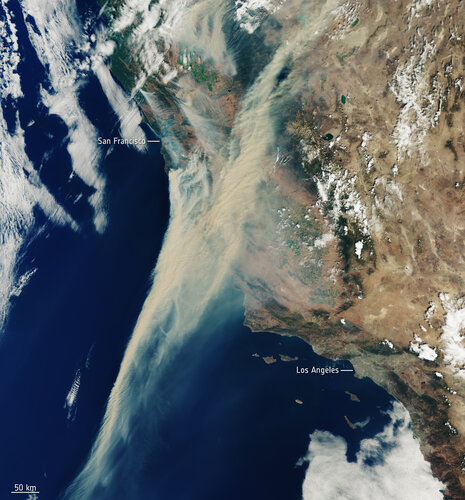 Image:
Captured on 19 August 2020, this Copernicus Sentinel-3 image shows the extent of the smoke from fires currently ablaze in California, US.
Image:
Captured on 19 August 2020, this Copernicus Sentinel-3 image shows the extent of the smoke from fires currently ablaze in California, US.
Vrchní referent / rada v oddělení aktualizace katastru nemovitostí Katastrálního pracoviště Trutnov
20.8.2020 12:06 ČÚZK /Urady/Katastralni-urady/Katastralni-urady/Katastralni-urad-pro-Kralovehradecky-kraj/Katastralni-pracoviste/KP-Trutnov/O-uradu/Aktuality/Vrchni-referent-rada-v-oddeleni-aktualizace-ka-(1)Vrchní referent / rada v oddělení aktualizace katastru nemovitostí Katastrálního pracoviště Trutnov
20.8.2020 12:06 ČÚZK - předpisy a opatření Katastrální úřad pro Královéhradecký kraj - Katastrální pracoviště Trutnov zveřejnil novou aktualitu: Vrchní referent / rada v oddělení aktualizace katastru nemovitostí Katastrálního pracoviště TrutnovPřeřušení provozu Sbírky listin ve čtvrtek 27.8.2020 od 16:30 do cca 19:30
20.8.2020 12:05 Dálkový přístup k údajům KN ČR Vážení uživatelé,oznamujeme, že z provozních důvodů nebude ve čtvrtek 27.8.2020 od 16:30 do cca 19:30 dostupné poskytování dokumentů ze Sbírky listin.
Za komplikace tímto způsobené se omlouváme a děkujeme za pochopení.
Přeřušení provozu Sbírky listin ve čtvrtek 27.8.2020 od 16:30 do cca 19:30
20.8.2020 12:05 ČÚZK - předpisy a opatření Vážení uživatelé,oznamujeme, že z provozních důvodů nebude ve čtvrtek 27.8.2020 od 16:30 do cca 19:30 dostupné poskytování dokumentů ze Sbírky listin.
Za komplikace tímto způsobené se omlouváme a děkujeme za pochopení.
Přeřušení provozu Sbírky listin ve čtvrtek 27.8.2020 od 16:30 do cca 19:30
20.8.2020 12:05 ČÚZK /Aplikace-DP-do-KN/Aplikace-DP-do-KN/Archiv-DP/298256Vrchní referent / rada v oddělení aktualizace katastru nemovitostí Katastrálního pracoviště Trutnov
20.8.2020 11:59 ČÚZK /Urady/Katastralni-urady/Katastralni-urady/Katastralni-urad-pro-Kralovehradecky-kraj/Uredni-deska/Oznameni-a-jina-uredni-sdeleni/Volna-mista/Vrchni-referent-rada-v-oddeleni-aktualizace-ka-(1)Vrchní referent / rada v oddělení aktualizace katastru nemovitostí Katastrálního pracoviště Trutnov
20.8.2020 11:59 ČÚZK - volná místa Katastrální úřad pro Královéhradecký kraj - Katastrální pracoviště Trutnov vypisuje výběrové řízení na místo Vrchní referent / rada v oddělení aktualizace katastru nemovitostí Katastrálního pracoviště TrutnovVrchní referent / rada v oddělení aktualizace katastru nemovitostí Katastrálního pracoviště Trutnov
20.8.2020 11:59 ČÚZK - předpisy a opatření Katastrální úřad pro Královéhradecký kraj - Katastrální pracoviště Trutnovvypisuje výběrové řízení na místo
Vrchní referent / rada v oddělení aktualizace katastru nemovitostí Katastrálního pracoviště Trutnov
Prázdninové verze 14.74 čekají na vás
20.8.2020 11:22 GEPROUžívejte si sluníčka a po návratu z letních dovolených zpátky domů a do práce můžete aktualizovat na nové verze 14.74 našich produktů MISYS, MISYS-WEB – licenční server, KOKEŠ, Geoportál GEPRO i PROLAND.… >>
Přihlašování na Konferenci GIS Esri v ČR je spuštěno
20.8.2020 10:13 ARCDATAPřihláška na virtuální Konferenci GIS Esri v ČR byla právě spuštěna. Přečtěte si podrobnosti a pokud máte navíc i nějaký zajímavý projekt, určitě neváhejte a využijte některou z možností prezentace.
Kdo se může přihlásit?
Výši registračního poplatku i rozsah uznávaných slev jsme letos přizpůsobili faktu, že konference bude probíhat virtuálně a toto největší setkání českých geoinformatiků jsme tak mohli udělat dostupnějším. Virtuální forma konference vám navíc zajistí i to, že stihnete opravdu každou přednášku či workshop, o který budete mít zájem.
Možnosti vlastní prezentace
Svoji práci můžete letos prezentovat dvojím způsobem – natočením přednášky nebo účastí v přehlídce map a online aplikací.
Záznam přednášky si můžete vytvořit sami, nebo vám s tím rádi pomůžeme v našem nahrávacím studiu. Co se přehlídky týče, přihlásit je možné webovou mapu, mapu s příběhem, online aplikaci i mapové dílo (mapu, plakát) ve formátu PDF. Více informací o možnostech prezentace získáte na samostatné stránce.
Takže – zbývá se již jen přihlásit.
Kartografická výročí 2020: 300 let Müllerovy mapy Čech
20.8.2020 8:50 GISportal.cz
Národní technické muzeum a Česká kartografická společnost, ve spolupráci s Historickým ústavem Akademie věd ČR, Fakultou stavební ČVUT v Praze, Filozofickou fakultou UJEP Ústí nad Labem a Českou geografickou společností, zvou na odborný seminář. Seminář k 300. výročí vydání výjimečného kartografického díla se koná ve čtvrtek 1. října 2020 od 10 hodin v konferenčním sále […]
The post Kartografická výročí 2020: 300 let Müllerovy mapy Čech appeared first on GISportal.cz.
Kartografická výročí 2020: 300 let Müllerovy mapy Čech
20.8.2020 8:50 GISportal.czNárodní technické muzeum a Česká kartografická společnost, ve spolupráci s Historickým ústavem Akademie věd ČR, Fakultou stavební ČVUT v Praze, Filozofickou fakultou UJEP Ústí nad Labem a Českou geografickou společností, zvou na odborný seminář. Seminář k 300. výročí vydání výjimečného kartografického díla se koná ve čtvrtek 1. října 2020 od 10 hodin v konferenčním sále […]
The post Kartografická výročí 2020: 300 let Müllerovy mapy Čech appeared first on GISportal.cz.
OGC and FAA invite participants to the SWIM Discovery Service (SDS) Technical Review Workshop
20.8.2020 1:10 GISCafe.com Webcasts-Webinars Workshop participants will be informed of a specification critical to the future of service discovery in a global SWIM …
Krajský pozemkový úřad v Hradci Králové je opět otevřen
20.8.2020 0:00 Státní pozemkový úřad Krajský pozemkový úřad v Hradci Králové je od dnešního dne (24. 8 2020) opět otevřen pro veřejnost.Krajský pozemkový úřad v Hradci Králové je do odvolání uzavřen veřejnosti, veškeré úkony a podání bude vyřizovat pouze elektronicky
20.8.2020 0:00 Státní pozemkový úřad Krajský pozemkový úřad v Hradci Králové je od čtvrtku 20. 8 2020 z provozně-technických důvodů uzavřen veřejnosti. Pracovníci KPÚ budou veškerá podání a žádosti vyřizovat POUZE elektronicky. Omezení KPÚ v Hradci Králové platí do odvolání.…and it’s a wrap! EUSPA Logo Contest submissions are now closed. Top finalists will be announced mid-October
19.8.2020 18:11 European GNSS Agency
The deadline for the submissions of new the European Union Space Programme Agency logo has expired.
The hunt for graphic designers is over! Friday 14th August 23:59 CET was the deadline for the submission of proposals for the EUSPA Logo Contest. We would like to thank all participants who submitted their projects for the logo of the new European Union Space Programme Agency (EUSPA) and congratulate them on their enthusiasm and creativity. A big thank you to all those who helped the Agency spread the word about the contest and reach out to new artistic communities.
The evaluation is ongoing and the selection committee, composed of experts in the field of communications, space and space user communities, will have a busy two-months reviewing the projects. The five nominated designs will be announced by mid-October 2020 and the finalists will be invited to negotiate a contract with the GSA in order for the latter to procure the logo, for a maximum budget of EUR 15.000 (fifteen thousand euros).
We are looking forward to the unveiling of the EUSPA logo, which will become the point of reference for the EU Space and GNSS user community, and celebrating the talent of the artist behind the new EUSPA logo.
To be up to date on the latest news, keep an eye on our website and social media. For any inquires you may have, please contact: logodesign@gsa.europa.eu
Good luck to everyone and stay tuned!
Media note: This feature can be republished without charge provided the European GNSS Agency (GSA) is acknowledged as the source at the top or the bottom of the story. You must request permission before you use any of the photographs on the site. If you republish, we would be grateful if you could link back to the GSA website (http://www.gsa.europa.eu).
…and it’s a wrap! EUSPA Logo Contest submissions are now closed. Top finalists will be announced mid-October
19.8.2020 18:11 European GNSS AgencyThe deadline for the submissions of new the European Union Space Programme Agency logo has expired.
The hunt for graphic designers is over! Friday 14th August 23:59 CET was the deadline for the submission of proposals for the EUSPA Logo Contest. We would like to thank all participants who submitted their projects for the logo of the new European Union Space Programme Agency (EUSPA) and congratulate them on their enthusiasm and creativity. A big thank you to all those who helped the Agency spread the word about the contest and reach out to new artistic communities.
The evaluation is ongoing and the selection committee, composed of experts in the field of communications, space and space user communities, will have a busy two-months reviewing the projects. The five nominated designs will be announced by mid-October 2020 and the finalists will be invited to negotiate a contract with the GSA in order for the latter to procure the logo, for a maximum budget of EUR 15.000 (fifteen thousand euros).
We are looking forward to the unveiling of the EUSPA logo, which will become the point of reference for the EU Space and GNSS user community, and celebrating the talent of the artist behind the new EUSPA logo.
To be up to date on the latest news, keep an eye on our website and social media. For any inquires you may have, please contact: logodesign@gsa.europa.eu
Good luck to everyone and stay tuned!
Media note: This feature can be republished without charge provided the European GNSS Agency (GSA) is acknowledged as the source at the top or the bottom of the story. You must request permission before you use any of the photographs on the site. If you republish, we would be grateful if you could link back to the GSA website (http://www.gsa.europa.eu).
…and it’s a wrap! EUSPA Logo Contest submissions are now closed. Top finalists will be announced mid-October
19.8.2020 18:11 European GNSS AgencyThe deadline for the submissions of the new European Union Space Programme Agency logo has expired.
The hunt for graphic designers is over! Friday 14th August 23:59 CET was the deadline for the submission of proposals for the EUSPA Logo Contest. We would like to thank all participants who submitted their projects for the logo of the new European Union Space Programme Agency (EUSPA) and congratulate them on their enthusiasm and creativity. A big thank you to all those who helped the Agency spread the word about the contest and reach out to new artistic communities.
The evaluation is ongoing and the selection committee, composed of experts in the field of communications, space and space user communities, will have a busy two-months reviewing the projects. The five nominated designs will be announced by mid-October 2020 and the finalists will be invited to negotiate a contract with the GSA in order for the latter to procure the logo, for a maximum budget of EUR 15.000 (fifteen thousand euros).
We are looking forward to the unveiling of the EUSPA logo, which will become the point of reference for the EU Space and GNSS user community, and celebrating the talent of the artist behind the new EUSPA logo.
To be up to date on the latest news, keep an eye on our website and social media. For any inquires you may have, please contact: logodesign@gsa.europa.eu
Good luck to everyone and stay tuned!
Media note: This feature can be republished without charge provided the European GNSS Agency (GSA) is acknowledged as the source at the top or the bottom of the story. You must request permission before you use any of the photographs on the site. If you republish, we would be grateful if you could link back to the GSA website (http://www.gsa.europa.eu).
Bees360 Releases Its Customizable API to Directly Integrate with Insurance Carriers Underwriting Platforms
19.8.2020 17:28 GISCafe.com Webcasts-Webinars HOUSTON, Aug. 19, 2020 — (PRNewswire) — Bees360, the innovator of deep learning and drone technology for property underwriting and claim …DPL Telematics Launches AssetView Max Tracking System for Affordable, Anti-Tamper Battery Powered GPS Tracking
19.8.2020 16:42 GISCafe.com Webcasts-Webinars As the industry's longest lasting battery powered GPS tracking solution the innovative, self-contained system can last up to 10 years on D …Valqari Introduces the Drone Delivery Station
19.8.2020 16:42 GISCafe.com Webcasts-Webinars Six-storage delivery solution showcases the start-up’s continued leadership in last inch drone delivery logisticsCHICAGO — (BUSINESS WIRE) …
Rada/Odborný rada – oddělení právních vztahů k nemovitostem
19.8.2020 16:21 ČÚZK - předpisy a opatření Katastrální úřad pro Karlovarský kraj Katastrální pracoviště Chebvypisuje výběrové řízení na místo
Rada/Odborný rada – oddělení právních vztahů k nemovitostem
Rada/Odborný rada – oddělení právních vztahů k nemovitostem
19.8.2020 16:21 ČÚZK - volná místa Katastrální úřad pro Karlovarský kraj Katastrální pracoviště Cheb vypisuje výběrové řízení na místo Rada/Odborný rada – oddělení právních vztahů k nemovitostemGoogle Maps přichází s novými barvami
19.8.2020 14:04 GISportal.cz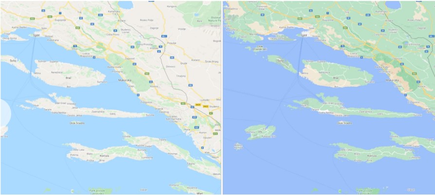
Uprostřed okurkové sezóny přichází Google Maps s novinkou, která změní vzhled jejich map prakticky po celém světě. Novinka vychází z toho, že Google analyzuje satelitní snímky jednotlivých oblastí a na jejich základě přiřazuje barvy z HSV modelu, aby více odpovídaly reálnému pokryvu. Tím se relativně “nudná” mapa například Islandu změní na “barevnější” a “realističtější” reprezentaci […]
The post Google Maps přichází s novými barvami appeared first on GISportal.cz.
Google Maps přichází s novými barvami
19.8.2020 14:04 GISportal.czUprostřed okurkové sezóny přichází Google Maps s novinkou, která změní vzhled jejich map prakticky po celém světě. Novinka vychází z toho, že Google analyzuje satelitní snímky jednotlivých oblastí a na jejich základě přiřazuje barvy z HSV modelu, aby více odpovídaly reálnému pokryvu. Tím se relativně “nudná” mapa například Islandu změní na “barevnější” a “realističtější” reprezentaci […]
The post Google Maps přichází s novými barvami appeared first on GISportal.cz.
24. kartografická konference (první info)
19.8.2020 9:49 GISportal.cz
Z pověření Výboru České kartografické společnosti byly zahájeny přípravy 24. kartografické konference, která se bude konat ve dnech 8.–10. září 2021 v Ostravě. Organizační výbor pod vedením Ing. Radka Duška, Ph.D., z Přírodovědecké fakulty Ostravské univerzity, zvolil pro konferenci motto CESTY KARTOGRAFIE. Konference bude hledat odpovědi na otázky současné kartografie: Odkud přicházíš? a Kam kráčíš?, […]
The post 24. kartografická konference (první info) appeared first on GISportal.cz.
24. kartografická konference (první info)
19.8.2020 9:49 GISportal.czZ pověření Výboru České kartografické společnosti byly zahájeny přípravy 24. kartografické konference, která se bude konat ve dnech 8.–10. září 2021 v Ostravě. Organizační výbor pod vedením Ing. Radka Duška, Ph.D., z Přírodovědecké fakulty Ostravské univerzity, zvolil pro konferenci motto CESTY KARTOGRAFIE. Konference bude hledat odpovědi na otázky současné kartografie: Odkud přicházíš? a Kam kráčíš?, […]
The post 24. kartografická konference (první info) appeared first on GISportal.cz.
INSPIRE prohlížecí služba WMS pro téma Vodstvo (HY)
19.8.2020 2:00 Cenia - Katalog metadat ČR - INSPIRE INSPIRE prohlížecí služba WMS pro téma Vodstvo (HY) poskytuje možnost prohlížet obraz dat INSPIRE tématu Vodstvo aplikačních schémat Fyzické vody a Hydrografická síť. Data jsou harmonizována dle prováděcích pravidel INSPIRE. Z aplikačního schématu Physical Waters obsahuje datová sada objekty typu Watercourse (osu i plochu u vodních toků širších než 4 m), StandingWater, LandWaterBoundary, Falls, Crossing (most, propustek, akvadukt), DamOrWeir, Ford a Lock; aplikační schéma Hydro-Network je reprezentováno objekty typu WatercourseLink, HydroNode a WatercourseSeparatedCrossing. Zdrojovou datovou sadou je Základní báze geografických dat České republiky (ZABAGED®). Služba splňuje Technické pokyny pro INSPIRE prohlížecí služby v. 3.11 a zároveň splňuje standard OGC WMS 1.1.1. a 1.3.0.INSPIRE datová sada pro téma Vodstvo - Fyzické vody (HY_P)
19.8.2020 2:00 Cenia - Katalog metadat ČR - INSPIRE Data INSPIRE tématu Vodstvo jsou harmonizována dle prováděcích pravidel INSPIRE a odpovídají INSPIRE xml schématu ve verzi 4.0 a ELF xml schématu ve verzi 1.0. Tato datová sada vodstva České republiky má proto jednotnou podobu s ostatními daty vytvářenými pro toto INSPIRE téma v rámci celé Evropy. Objekty jsou reprezentovány vektorovou složkou s atributy, které obsahují další informace o objektech. Zdrojovou datovou sadou je Základní báze geografických dat České republiky (ZABAGED®). Datová sada je zpracována dle aplikačního schématu Physical Waters a obsahuje objekty typu Watercourse (osu i plochu u vodních toků širších než 4 m), StandingWater, LandWaterBoundary, Falls, Crossing (most, propustek, akvadukt), DamOrWeir, Ford a Lock. Atributy jsou vyplněny na základě dat ZABAGED® (včetně jména), případně data, která lze odvodit (např. velikost plochy) a hodnot, které jsou pro sadu konstantní (např. skutečnost, že jméno je v češtině a psáno latinkou).Campus maps for students with visual impairments open up the higher education experience
18.8.2020 19:52 GISCafe.com Webcasts-Webinars SAS launches free resources to create and share non-visual digital mapsCARY, N.C., Aug. 18, 2020 — (PRNewswire) — Many new …
Nové číslo Zpravodaje ČKS (3/2020)
18.8.2020 16:20 Česká kartografická společnost Přinášíme Vám nové číslo Zpravodaje České kartografické společnosti. Prolistovat si jej můžete níže i online. Přejeme příjemné čtení!Liteye Launches On-the-Move (OTM) C-UAS Solution
18.8.2020 15:57 GISCafe.com Webcasts-Webinars Centennial, Colorado, Aug. 18, 2020 (GLOBE NEWSWIRE) -- Centennial, Colorado — August 18, 2020 - Liteye Systems Inc. announces the Trailer …Velodyne Lidar With Kaarta Cloud Can Produce Stunning 3D Maps
18.8.2020 15:57 GISCafe.com Webcasts-Webinars High quality lidar processing enables fast mobile mapping for diverse applicationsSAN JOSE, Calif. — (BUSINESS WIRE) — August 18, 2020 …
L3Harris Technologies Awarded Medium Unmanned Surface Vehicle Program from US Navy
18.8.2020 15:57 GISCafe.com Webcasts-Webinars Highlights:Program is the first U.S. Navy program for medium unmanned surface vehicles
Technology supports advanced autonomy in operational …
Změna úředních hodin
18.8.2020 12:34 ČÚZK - předpisy a opatření Katastrální úřad pro Ústecký kraj - Katastrální pracoviště Most zveřejnil novou aktualitu: V rámci sjednocování úředních hodin v resortu, dojde od 1.9.2020 ke změně úředních hodin.Změna úředních hodin
18.8.2020 12:34 ČÚZK /Urady/Katastralni-urady/Katastralni-urady/Katastralni-urad-pro-Ustecky-kraj/Katastralni-pracoviste/KP-Most/O-uradu/Aktuality/Zmena-urednich-hodinVolná místa - 18.08.2020
18.8.2020 12:29 ČÚZK - předpisy a opatření Katastrální úřad pro hlavní město Prahu zveřejnil novou aktualitu: Ředitel úřadu vyhlašuje výběrové řízení na zástup služebního místa - pracovní poměr na dobu určitou:referent KN –vedení DKM, vedení katastrální mapy
Volná místa - 18.08.2020
18.8.2020 12:29 ČÚZK /Urady/Katastralni-urady/Katastralni-urady/Katastralni-urad-pro-hlavni-mesto-Prahu/O-uradu/Aktuality/Volna-mista-18-08-2020Volná místa - 18.08.2020
18.8.2020 12:29 ČÚZK - předpisy a opatření Katastrální úřad pro hlavní město Prahu zveřejnil novou aktualitu: Ředitel úřadu vyhlašuje výběrové řízení na zástup služebního místa - pracovní poměr na dobu určitou:referent KN –vedení DKM, vedení katastrální mapy
referent KN – vedení DKM, vedení katastrální mapy
18.8.2020 12:08 ČÚZK - předpisy a opatření Katastrální úřad pro hlavní město Prahuvypisuje výběrové řízení na místo referent KN
referent KN – vedení DKM, vedení katastrální mapy
referent KN – vedení DKM, vedení katastrální mapy
18.8.2020 12:08 ČÚZK - předpisy a opatření Katastrální úřad pro hlavní město Prahu - Katastrální pracoviště Prahavypisuje výběrové řízení na místo referent KN
referent KN – vedení DKM, vedení katastrální mapy
referent KN – vedení DKM, vedení katastrální mapy
18.8.2020 12:08 ČÚZK /Urady/Katastralni-urady/Katastralni-urady/Katastralni-urad-pro-hlavni-mesto-Prahu/Volna-mista/referent-KN-–-vedeni-DKM,-vedeni-katastralni-mapyreferent KN – vedení DKM, vedení katastrální mapy
18.8.2020 12:08 ČÚZK - volná místa Katastrální úřad pro hlavní město Prahu vypisuje výběrové řízení na místo referent KN – vedení DKM, vedení katastrální mapyreferent KN – vedení DKM, vedení katastrální mapy
18.8.2020 12:08 ČÚZK - volná místa Katastrální úřad pro hlavní město Prahu - Katastrální pracoviště Praha vypisuje výběrové řízení na místo referent KN – vedení DKM, vedení katastrální mapy20200818 odborný referent/ vrchní referent v oddělení dokumentace KN
18.8.2020 11:12 ČÚZK - předpisy a opatření Katastrální úřad pro Středočeský kraj - Katastrální pracoviště Praha-východ Nabídka pracovní pozice na systemizované místo: Odborný referent/ vrchní referent v oddělení dokumentace KN V části "Volná místa", bylo vystaveno "Nabídka pracovní pozice na systemizované místo Odborný referent/ vrchní referent v oddělení dokumentace KN"20200818 odborný referent/ vrchní referent v oddělení dokumentace KN
18.8.2020 11:12 ČÚZK /Urady/Katastralni-urady/Katastralni-urady/Katastralni-urad-pro-Stredocesky-kraj/O-uradu/Aktuality/20200818-odborny-referent-vrchni-referent-v-oddel20200818 odborný referent/ vrchní referent v oddělení dokumentace KN
18.8.2020 11:10 ČÚZK - předpisy a opatření Katastrální úřad pro Středočeský kraj - Katastrální pracoviště Praha-východ Nabídka pracovní pozice na systemizované místo: Odborný referent/ vrchní referent v oddělení dokumentace KN V části "Volná místa", bylo vystaveno "Nabídka pracovní pozice na systemizované místo Odborný referent/ vrchní referent v oddělení dokumentace KN"20200818 odborný referent/ vrchní referent v oddělení dokumentace KN
18.8.2020 11:10 ČÚZK /Urady/Katastralni-urady/Katastralni-urady/Katastralni-urad-pro-Stredocesky-kraj/Katastralni-pracoviste/KP-Praha-vychod/O-uradu/Aktuality/20200818-odborny-referent-vrchni-referent-v-oddelPozvánka na společnou konferenci Inspirujme se a české uživatelské fórum Copernicus
18.8.2020 8:46 GISportal.cz
CENIA, česká informační agentura životního prostředí, Ministerstvo životního prostředí ČR, Ministerstvo životného prostredia SR a Ministerstvo dopravy ČR Vás zvou na společnou konferenci Inspirujme se a českého uživatelského fóra Copernicus, která se letos uskuteční ve dnech 7. – 8. 10. 2020 v Praze za podpory Institutu plánování a rozvoje hl. m. Prahy. Tento ročník nese […]
The post Pozvánka na společnou konferenci Inspirujme se a české uživatelské fórum Copernicus appeared first on GISportal.cz.
Pozvánka na společnou konferenci Inspirujme se a české uživatelské fórum Copernicus
18.8.2020 8:46 GISportal.czCENIA, česká informační agentura životního prostředí, Ministerstvo životního prostředí ČR, Ministerstvo životného prostredia SR a Ministerstvo dopravy ČR Vás zvou na společnou konferenci Inspirujme se a českého uživatelského fóra Copernicus, která se letos uskuteční ve dnech 7. – 8. 10. 2020 v Praze za podpory Institutu plánování a rozvoje hl. m. Prahy. Tento ročník nese […]
The post Pozvánka na společnou konferenci Inspirujme se a české uživatelské fórum Copernicus appeared first on GISportal.cz.
Vrchní referent/rada v oddělení aktualizace PI KN č.1 na katastrálním pracovišti Brno - venkov
18.8.2020 6:45 ČÚZK - předpisy a opatření Katastrální úřad pro Jihomoravský kraj Katastrální pracoviště Brno-venkovvypisuje výběrové řízení na místo
Vrchní referent/rada v oddělení aktualizace PI KN č.1 na katastrálním pracovišti Brno - venkov
Vrchní referent/rada v oddělení aktualizace PI KN č.1 na katastrálním pracovišti Brno - venkov
18.8.2020 6:45 ČÚZK /Urady/Katastralni-urady/Katastralni-urady/Katastralni-urad-pro-Jihomoravsky-kraj/Volna-mista/DMS/Vrchni-referent-rada-v-oddeleni-aktualizace-PI-KNVrchní referent/rada v oddělení aktualizace PI KN č.1 na katastrálním pracovišti Brno - venkov
18.8.2020 6:45 ČÚZK - volná místa Katastrální úřad pro Jihomoravský kraj Katastrální pracoviště Brno-venkov vypisuje výběrové řízení na místo Vrchní referent/rada v oddělení aktualizace PI KN č.1 na katastrálním pracovišti Brno - venkovPobočka Písek je do odvolání uzavřena veřejnosti, veškeré úkony a podání bude vyřizovat pouze elektronicky
18.8.2020 0:00 Státní pozemkový úřad Pobočka Písek je od úterý 18. srpna 2020 z provozně-technických důvodů uzavřena veřejnosti. Pracovníci pobočky budou veškerá podání a žádosti vyřizovat POUZE elektronicky. Omezení provozu Pobočky Písek platí do odvolání.Pobočka Písek je opět otevřena veřejnosti
18.8.2020 0:00 Státní pozemkový úřad Pobočka Písek je od čtvrtku 20. srpna 2020 opět otevřena veřejnosti.Pobočka Písek je opět otevřena veřejnosti
18.8.2020 0:00 Státní pozemkový úřad Pobočka Písek je od čtvrtku 20. srpna 2020 opět otevřena veřejnosti.Pobočka Písek je do odvolání uzavřena veřejnosti, veškeré úkony a podání bude vyřizovat pouze elektronicky
18.8.2020 0:00 Státní pozemkový úřad Pobočka Písek je od úterý 18. srpna 2020 z provozně-technických důvodů uzavřena veřejnosti. Pracovníci pobočky budou veškerá podání a žádosti vyřizovat POUZE elektronicky. Omezení provozu Pobočky Písek platí do odvolání.Esri Tech to Help Modernize Vermont Department of Taxes
17.8.2020 22:43 GISCafe.com Webcasts-Webinars Esri Partner Axiomatic Will Design Solutions to Promote Fair and Equitable TaxationREDLANDS, Calif. — (BUSINESS WIRE) — August 17, 2020 …
Deuce Drone Demonstrates Automated and Vision Based Flight Control in Multi-Stop Delivery of Groceries and Food
17.8.2020 19:49 GISCafe.com Webcasts-Webinars MOBILE, AL, Aug. 17, 2020 (GLOBE NEWSWIRE) -- via NEWMEDIAWIRE -- Deuce Drone today announced that it completed a technology demonstration of its …Australia's Younger Agricultural Workforce Step up with XAG Drone for the Soaring Winter Crops
17.8.2020 19:49 GISCafe.com Webcasts-Webinars BUNDABERG, Australia, Aug. 17, 2020 — (PRNewswire) — Observing an increasingly growing demand of unmanned device applications during …Commercial UAV Expo Americas Virtual Conference to Feature DRONERESPONDERS Public Safety UAS Content produced by AIRT
17.8.2020 19:49 GISCafe.com Webcasts-Webinars Public safety and emergency services drone pilots from across the globe will gather virtually to share use cases, best practices, and key learnings …Vega launch now set for 1 September
17.8.2020 17:55 ESA Observing the Earth
A new launch date of 1 September 2020 has been announced by Arianespace for Vega flight VV16.
Vega launch now set for 1 September
17.8.2020 17:55 ESA Observing the Earth
Vega will return to flight on its debut rideshare mission dedicated to light satellites with liftoff at 02:51 BST / 03:51 CEST on 2 September (22:51 local time on 1 September).
Vega launch set for 1 September
17.8.2020 17:55 ESA Observing the Earth
Vega will return to flight on its debut rideshare mission dedicated to light satellites with liftoff at 02:51 BST / 03:51 CEST on 2 September (22:51 local time on 1 September).
2020 URISA Exemplary Systems in Government Award Recipients Announced
17.8.2020 17:31 GISCafe.com Webcasts-Webinars Des Plaines, IL (August 17, 2020) The URISA Exemplary Systems in Government (ESIG) awards were first presented in 1981 to recognize outstanding …Hexagon adds powerful visual positioning technology to best-in-class survey-grade GNSS RTK rover
17.8.2020 15:51 GISCafe.com Webcasts-Webinars NACKA STRAND, Sweden, Aug. 17, 2020 — (PRNewswire) — Hexagon AB, a global leader in sensors, software and autonomous solutions, …Maxar’s 1300-Class Broadcasting Satellite Built for B-SAT Performing According to Plan After Launch
17.8.2020 15:51 GISCafe.com Webcasts-Webinars B-SAT will use the satellite to expand its 4K/8K ultra-high definition direct-to-home video service in JapanWESTMINSTER, Colo. — (BUSINESS …
New BlackSky Satellites Deliver First Images Within 58 Hours of Launch
17.8.2020 15:51 GISCafe.com Webcasts-Webinars Images Immediately Provide Customers Actionable InsightsHERNDON, Va. — (BUSINESS WIRE) — August 17, 2020 —
BlackSky, a leading …
AgEagle Aerial Systems Reports Second Quarter 2020 Results
17.8.2020 15:51 GISCafe.com Webcasts-Webinars NEODESHA, Kan., Aug. 17, 2020 (GLOBE NEWSWIRE) -- AgEagle Aerial Systems Inc. (NYSE American: UAVS) (“AgEagle or the “Company”), an industry …Woolpert Launches GeoAwareness Solution for Curbside Pickup Upon Arrival
17.8.2020 15:50 GISCafe.com Webcasts-Webinars This quick-start, real-time solution streamlines operations and improves customer serviceDAYTON, Ohio, Aug. 17, 2020 — (PRNewswire) — …
MGISS Partners with European Space Agency to Sponsor Northumbrian Water Innovation Festival
17.8.2020 15:50 GISCafe.com Webcasts-Webinars Liverpool, UK, 17 August 2020 – Mobile GIS Services (MGISS) is working with the European Space agency (ESA) to showcase the potential of …Intermap Technologies Satisfies All Senior Secured Debt Obligations
17.8.2020 15:47 GISCafe.com Webcasts-Webinars DENVER, Aug. 17, 2020 — (PRNewswire) — Intermap Technologies Corporation ("Intermap" or the "Company") today announced that it closed …Odstávka elektřiny KP KA 3. 9. 2020
17.8.2020 14:25 ČÚZK /Urady/Katastralni-urady/Katastralni-urady/Katastralni-urad-pro-Moravskoslezsky-kraj/Katastralni-pracoviste/KP-Karvina/O-uradu/Aktuality/Odstavka-elektriny-KP-KA-3-9-2020Odstávka elektřiny KP KA 3. 9. 2020
17.8.2020 14:25 ČÚZK - předpisy a opatření Katastrální úřad pro Moravskoslezský kraj - Katastrální pracoviště Karviná zveřejnil novou aktualitu: Katastrální úřad pro Moravskoslezský kraj, Katastrální pracoviště Karviná informuje, že společnost ČEZ Distribuce, a.s. oznámila na adrese sídla pracoviště, Slámova 183/1, Fryštát, 733 01 Karviná: přerušení dodávky elektřiny dne 3. 9. 2020 v době od 7:15 do 16:00 hod. Z uvedeného důvodu budou v tento den služby v budově Katastrálního pracoviště Karviná omezeny pouze na přijetí podání na podatelně.Děkujeme za pochopení.
odborný referent/vrchní referent – návrh zápisu v katastru
17.8.2020 14:06 ČÚZK - předpisy a opatření Katastrální úřad pro Olomoucký kraj - Katastrální pracoviště Prostějovvypisuje výběrové řízení na místo
odborný referent/vrchní referent – návrh zápisu v katastru
odborný referent/vrchní referent – návrh zápisu v katastru
17.8.2020 14:06 ČÚZK /Urady/Katastralni-urady/Katastralni-urady/Katastralni-urad-pro-Olomoucky-kraj/Uredni-deska/Oznameni-a-jina-uredni-sdeleni/Volna-mista/odborny-referent-vrchni-referent-–-navrh-zapisu-vodborný referent/vrchní referent – návrh zápisu v katastru
17.8.2020 14:06 ČÚZK - volná místa Katastrální úřad pro Olomoucký kraj - Katastrální pracoviště Prostějov vypisuje výběrové řízení na místo odborný referent/vrchní referent – návrh zápisu v katastruAutoCarto 2020 Online
17.8.2020 13:12 Česká kartografická společnost Konference AutoCarto 2020 z důvodu proti-pandemických opatření proběhne online. Konference proběhne ve středu 18. listopadu 2020. Deadline pro rozšířené abstrakty je 15. září 2020, termín pro přihlášení opravených abstraktů je do 30. září 2020. Prezentace musí být nahrány do 10. listopadu 2020. Více informací na webových stránkách.GSA lands safely at Prague’s EGNOS-enabled Airport for Runway Park 2020
17.8.2020 12:59 European GNSS Agency
The European GNSS Agency and its crew touched down on the runway of the Vaclav Havel Airport in Prague to highlight the benefits of the EU Space Programme in the Czech Republic.
GSA’s crew took part to the Runway Park 2020, an event gathering aviation enthusiasts, plane spotters and families, held at the old runway of Prague’s Vaclav Havel Airport. During the event, the apron is transformed into an open-air exhibition offering a wide range of activities for all age groups. True to its mission – linking space to user needs - the European GNSS Agency was there to raise awareness about the EU Space programme and the benefits it is already delivering to citizens and business alike.
With over 2000 visitors, at the GSA stand, people had the chance to experience and learn about applications based on the EU Space Programme, in particular Galileo and EGNOS. The lifesaving capabilities of the EU space technologies took centre stage when visitors experienced a helicopter rescue on the snow-capped Alps with the help of Galileo, while crafty hands were busy honing their space skills by building small scale satellite mock-ups, taking quizzes and winning prizes.
A highlight of this four-day event was the “Land with EGNOS” flight simulator. Visitors were able to “land” an Airbus A350 using EGNOS, the EU’s regional navigation system that provides the additional reliability essential for applications where position integrity is critical, such as in the aviation sector.
Read this: EGNOS goes from strength to strength
“EGNOS is a win-win solution for the airliners, the airports and the ANSP´s. It makes airports accessible under bad weather conditions while it is central to the safety of passengers and crew. EGNOS based approach procedures can be implemented at many airports without the need to invest in conventional facilities. Such procedures are published at all airports where Air Navigation Service of the Czech Republic provides services and air carriers can benefit from increased safety and accessibility of the airports,“ said Jan Klas, Director General at the Air Navigation Service of the Czech Republic.
Prague Airport, an early adopter of the EGNOS technology, will soon release a Corporate Social Responsibility report emphasizing how the system can help the airport go greener.
“Investing in EU Space technology is pivotal for rolling out cleaner forms of transport while ensuring a sustainable European economy. To this day, more than 350 European airports have implemented EGNOS procedures, and the GSA is working with Member States, airlines, air traffic regulators and airports to increase this number and accelerate progress towards the ambitious EU Green Deal,” concludes Pascal Claudel, Acting Executive Director at the GSA.
GSA lands safely at Prague’s EGNOS-enabled Airport for Runway Park 2020
17.8.2020 12:59 European GNSS AgencyThe European GNSS Agency and its crew touched down on the runway of the Vaclav Havel Airport in Prague to highlight the benefits of the EU Space Programme in the Czech Republic.
GSA’s crew took part to the Runway Park 2020, an event gathering aviation enthusiasts, plane spotters and families, held at the old runway of Prague’s Vaclav Havel Airport. During the event, the apron is transformed into an open-air exhibition offering a wide range of activities for all age groups. True to its mission – linking space to user needs - the European GNSS Agency was there to raise awareness about the EU Space programme and the benefits it is already delivering to citizens and business alike.
With over 2000 visitors, at the GSA stand, people had the chance to experience and learn about applications based on the EU Space Programme, in particular Galileo and EGNOS. The lifesaving capabilities of the EU space technologies took centre stage when visitors experienced a helicopter rescue on the snow-capped Alps with the help of Galileo, while crafty hands were busy honing their space skills by building small scale satellite mock-ups, taking quizzes and winning prizes.
A highlight of this four-day event was the “Land with EGNOS” flight simulator. Visitors were able to “land” an Airbus A350 using EGNOS, the EU’s regional navigation system that provides the additional reliability essential for applications where position integrity is critical, such as in the aviation sector.
Read this: EGNOS goes from strength to strength
EGNOS is a win-win solution for both airlines and airports. It makes airports accessible under bad weather conditions while it is central to the safety of both passengers and the crew. Furthermore, EGNOS reduces the amount of noise and emissions produced by the aircraft during the approach.
Prague Airport, an early adopter of the EGNOS technology, will soon release a Corporate Social Responsibility report emphasizing how the system can help the airport go greener.
“Investing in EU Space technology is pivotal for rolling out cleaner forms of transport while ensuring a sustainable European economy. To this day, more than 350 European airports have implemented EGNOS procedures, and the GSA is working with Member States, airlines, air traffic regulators and airports to increase this number and accelerate progress towards the ambitious EU Green Deal,” concludes Pascal Claudel, Acting Executive Director at the GSA.
obnova katastrálního operátu
17.8.2020 12:59 ČÚZK - předpisy a opatření Katastrální úřad pro Olomoucký kraj - technický odborvypisuje výběrové řízení na místo
obnova katastrálního operátu
obnova katastrálního operátu
17.8.2020 12:59 ČÚZK - volná místa Katastrální úřad pro Olomoucký kraj - technický odbor vypisuje výběrové řízení na místo obnova katastrálního operátuHrdlička Holding a Neogenia spojily síly
17.8.2020 10:54 Hrdlička Společně nahrazují aplikaci ProblemReport za Mobilní rozhlas.Výstava nominovaných produktů Mapa roku 2019
17.8.2020 10:31 Česká kartografická společnost Ve dnech 22. srpna až 24. září 2020 bude probíhat v interaktivním muzeu vědy Pevnost poznání v Olomouci výstava MAPY A MAPY. Vystaveny zde budou všechny nominované produkty na ocenění Mapa roku 2019. V zachovalém areálu korunní pevnůstky v Olomouci sídlí vzácná historická stavba s dřevěnou konstrukcí. Ještě v roce 1857 byla neoddělitelnou součástí bastionové pevnosti. Zatímco ale tehdy se v ní […]"Using Geolocation Technology to Fight Covid-19 and Climate Change" by Susan Smith
17.8.2020 9:40 GISCafe.com Webcasts-WebinarsSrpnový mapathon (pozvánka)
17.8.2020 8:35 GISportal.cz
Lékaři bez hranic zvou na srpnový online Missing Maps mapathon, který se uskuteční 25. srpna v čase od 18:00 do 20:00.
The post Srpnový mapathon (pozvánka) appeared first on GISportal.cz.
20200817-GaKO-8-2020
17.8.2020 8:18 ČÚZK - předpisy a opatření Český úřad zeměměřický a katastrální zveřejnil novou aktualitu: Aktuální číslo Geodetického a kartografického obzoru (8/2020) je k dispozici ke stažení.20200817-GaKO-8-2020
17.8.2020 8:18 ČÚZK - předpisy a opatření Český úřad zeměměřický a katastrální zveřejnil novou aktualitu: Aktuální číslo Geodetického a kartografického obzoru (8/2020) je k dispozici ke stažení.
Nové číslo GaKO
17.8.2020 8:00
ÚGKK SR
Nové číslo časopisu Geodetického a Kartografického Obzoru 08/2020
Postdoc position @ UIUC’s CyberGIS Center
16.8.2020 19:35 UIUC’s CyberGIS Center is recruiting a postdoctoral fellow to play key roles in research and education activities of multiple projects related to spatial modeling and simulation, geographic information science and systems (GIS), cyberGIS, machine learning, and/or geospatial approaches to solving public health problems. The application deadline is August 15, 2020: https://cybergis.illinois.edu/career/postdoctoral-researcher-july-21-2020/. Your help for spreading the word […]Two open PhD positions at Department of Physical Geography and Ecosystem Science, Lund University, Sweden
16.8.2020 19:34 We have two open PhD positions at Department of Physical Geography and Ecosystem Science, Lund University, Sweden. Below are links to details of the two positions. Position-1: Doctoral student in remote sensing and ecosystem modelling (last application date: 30 September 2020) Swedish https://lu.varbi.com/se/what:job/jobID:347255/type:job/where:4/apply:1 English https://lu.varbi.com/en/what:job/jobID:347255/type:job/where:4/apply:1 Position-2: Doctoral Student in hydrological modelling and remote sensing (last […]GaKO 8/2020
15.8.2020 15:16 GaKO GaKO 8/2020 BRÁZDIL, K.-PRESSOVÁ, J.-ŠÍMA, J.: Realizovaná zpřesnění polohy vybraných objektů Základní báze geografických dat (ZABAGED®) SEMRÁD, L.-STACHOŇ, Z.-KRTIČKA, L.: Poruchy barvocitu a mapy pro orientační běhGaKO 8/2020
15.8.2020 15:16 GaKO GaKO 8/2020 BRÁZDIL, K.-PRESSOVÁ, J.-ŠÍMA, J.: Realizovaná zpřesnění polohy vybraných objektů Základní báze geografických dat (ZABAGED®) SEMRÁD, L.-STACHOŇ, Z.-KRTIČKA, L.: Poruchy barvocitu a mapy pro orientační běhKolik by bude stát nový Národní geoportál INSPIRE?
15.8.2020 8:53 GISportal.cz
Česká informační agentura životního prostředí (CENIA) právě poptává “Zjištění ceny „Dodávka řešení Geoportálu“”. Pokud si myslíte, že byste jako firma mohli takový portál postavit – CENIA nyní zatím zjišťuje pouze případnou cenu – nejedná se výběrové řízení, ale spíše průzkum trhu, podívejte se na popis níže. Jak by měl nový národní geoportál vypadat?: Řešení Geoportál […]
The post Kolik by bude stát nový Národní geoportál INSPIRE? appeared first on GISportal.cz.
Immense Simulations: Now Powered by the World’s #1 Location Platform
14.8.2020 20:26 GISCafe.com Webcasts-Webinars London, 11th August 2020. Two transport insights specialists are joining forces to provide an improved way for mobility providers to identify revenue …ATLAS and BlackSky Harness Expanded Earth Observation Capabilities
14.8.2020 17:31 GISCafe.com Webcasts-Webinars TRAVERSE CITY, Mich. — (BUSINESS WIRE) — August 14, 2020 —ATLAS Space Operations, a leading innovator in ground communications …