


![]()

zprávy
zdroje zpráv:Přerušení provozu Pobočky Teplice
3.8.2020 0:00 Státní pozemkový úřad Z důvodu havárie na vodovodním řadu bude dnes od 10.30 do 16.30 uzavřena Pobočka Teplice. V případě nutnosti kontaktujte Krajský pozemkový úřad pro Ústecký kraj, tel. 727 956 872 nebo e-mail: ustecky.kraj@spucr.cz. Děkujeme za pochopení.APG má oporu i ve vedení Hospodářské komory
31.7.2020 20:00 Asociace podnikatelů v geomatice Všichni APG podporování kandidáti se dostali do vedení Hospodářské komory ČR, a to i hlasem naší asociace. Jedná se především o Vladimíra Dlouhého, Zdeňka Zajíčka a Michala Štefla. Podpora těchto kandidátů byla motivována jejich aktivní podporou projektů, na kterých se APG podílí. Jedná se především o DTM, DSŘ a BIM. Těšíme se s nimi na další spolupráci i v těchto funkcích.1Spatial unlocks the key to joined-up government
31.7.2020 18:32 GISCafe.com Webcasts-Webinars Cambridge, UK, 14th July 2020, (www.1spatial.com) 1Spatial, a global leader in Location Master Data Management (LMDM) software and solutions and …1Spatial become a member of techUK
31.7.2020 17:55 GISCafe.com Webcasts-Webinars Cambridge, UK, 16 July 2020, (www.1spatial.com) 1Spatial, a global leader in Location Master Data Management software, solutions and business …Interview: Easing the remote work transition with ProjectWise 365
31.7.2020 17:18 Bentley SystemsPress Coverage
SPAR 3D, USA
Read the articleBAE Systems Completes Acquisition of Military GPS Business
31.7.2020 17:13 GISCafe.com Webcasts-Webinars NASHUA, N.H. — (BUSINESS WIRE) — July 31, 2020 —BAE Systems has completed its acquisition of the Collins Aerospace Military …
Data insights will define post-coronavirus city planning
31.7.2020 17:06 Bentley SystemsPress Coverage
Computer Weekly, UK
Read the articleBentley Systems offers full access to LEGION Simulator and OpenBuildings Station Designer
31.7.2020 16:57 Bentley SystemsPress Coverage
GraphicSpeak, USA
Read the articleReplacing Traditional 2-D Plans with 3-D Digital Models on the Iowa I-80/380 BIM Pilot Project
31.7.2020 16:51 Bentley SystemsPress Coverage
Roads & Bridges, USA
Read the article"Talking with Becky Tamashasky of Cityworks" by Susan Smith
31.7.2020 16:27 GISCafe.com Webcasts-WebinarsBentley buys voice-based construction app maker
31.7.2020 16:04 Bentley SystemsPress Coverage
Schnitger Corporation, USA
Read the articleL3Harris Reports Second Quarter 2020 Results
31.7.2020 15:58 GISCafe.com Webcasts-Webinars 2Q20 revenue$4.4 billion, up 138% and flat versus prior-year GAAP and pro forma1, respectively
Up 2.3% on an organic2 basis; funded …
Road and Bridge Digital Twins in Action: Four Case Studies
31.7.2020 15:36 Bentley SystemsPress Coverage
Cadalyst, USA
Read the articleShell Polymers Utilizes Drone Technology to Capture Real-time Data on a Large Ethane Cracking Plant
31.7.2020 15:16 Bentley SystemsPress Coverage
Civil + Structural Engineer, USA
Read the articleBentley Systems’ Year in Infrastructure 2020 Conference is Going Digital
31.7.2020 15:14 Bentley SystemsPress Coverage
Geomatics World, UK
Read the articleBentley Systems’ Year in Infrastructure 2020 Conference is Going Digital!
31.7.2020 15:12 Bentley SystemsPress Coverage
Global Banking & Finance Review, UK
Read the articleAdvancing Digital Twins to improve asset performance
31.7.2020 15:08 Bentley SystemsPress Coverage
Engineering Specifier, UK
Read the articleBrigáda
31.7.2020 13:50 Katedra geoinformatiky UP OlomoucFirma Agpol s.r.o. hledá šikovného studenta/studentku na tvorbu mapových výstupů a jednoduchých GIS analýz v rámci zpracovávané studie ÚSES. Práce v programu ArcMap. Práce možná vzdáleně, kontrola formou konzultace (max. 1 x týdně v Olomouci). V případě zájmu kontaktujte Ing. Jakuba Feltla, Ph.D. na feltl@agpol.cz.
The post Brigáda appeared first on Katedra geoinformatiky.
First GNSS Asia Market & Technology Trends Report now available
31.7.2020 11:09 European GNSS Agency
GNSS.asia, a Horizon-2020 project of the European GNSS Agency (GSA) that aims to stimulate the creation of partnerships between GNSS industries in Europe and Asia, has announced the publication of its first Market and Technology Trends Report for the Asian market. Packed with key insights from GNSS.asia teams on the ground in Asia, this report, provided on quarterly basis, is a must read for companies looking to expand into Asian markets or to cooperate with Asian companies and institutions.
The GNSS.asia report shares the latest GNSS developments in Asia (Taiwan, China, South Korea, India, Japan and Australasia), including information on upstream developments, covering satellites and satellite augmentation systems, ground equipment, policy initiatives and much more.
Key highlights
Highlights from the report include details on new SBAS developments in both Australasia and Korea, the finalisation of BDS-3 in China, the use of GNSS in the fight against both COVID-19 and wildfires in Australia, the mandatory introduction of emergency call devices in new vehicles in Japan, and many other interesting developments.
Read this: Horizon 2020 key to international cooperation for Galileo & EGNOS
Some key findings:
• Companies in Japan are looking to take advantage of QZSS, but there is a major barrier to entry for companies due to the high price of the receivers.
• The expansion of Taiwanese and South Korean domestic satellite supply chains is a key target for partnership opportunities.
• The improvements brought about by the development of the new Australia-New Zealand SBAS will provide an entire new set of downstream applications across all segments.
• Japan’s mandatory introduction of a vehicle emergency call function that is compatible with the European e-Call opens up the market to companies from Europe.
To read the report in full, click here.
About GNSS.asia
GNSS.asia is a H2020 project of the European GNSS Agency (GSA) that aims to stimulate the creation of partnerships between GNSS industries in Europe and Asia, while supporting institutional cooperation and encouraging Galileo adoption. It offers several services, including industry matchmaking and international cooperation events. You can register for industry support on the GNSS.asia website.
And this: Space synergies to drive economic growth and job creation
To stay up-to-date on the latest news and innovation from Asia – including the second issue of the GNSS.asia Market & Technology Trends insight report – subscribe to GNSS.asia’s monthly newsletter here.
Media note: This feature can be republished without charge provided the European GNSS Agency (GSA) is acknowledged as the source at the top or the bottom of the story. You must request permission before you use any of the photographs on the site. If you republish, we would be grateful if you could link back to the GSA website (http://www.gsa.europa.eu).
Contract signed to build Europe’s carbon dioxide monitoring mission
31.7.2020 10:56 ESA Observing the Earth
With the amount of carbon dioxide in Earth’s atmosphere approaching levels that humans may have never before experienced, the need to monitor sources of emissions is more urgent than ever – hence the Copernicus Carbon Dioxide Monitoring mission being one of Europe’s new high-priority satellite missions. Taking the mission a significant step forward, ESA and OHB System AG have, today, signed a contract to build the first two satellites that make up the mission.
20200731 Odborný referent oddělení aktualizace PI KN II.
31.7.2020 10:31 ČÚZK - předpisy a opatření Katastrální úřad pro Středočeský kraj - Katastrální pracoviště Praha-východ Vyhlášení výběrového řízení: Odborný referent oddělení aktualizace PI KN II. V části "Úřední deska", v sekci "Oznámení a jiná úřední sdělení" bylo vystaveno "Oznámení o vyhlášení výběrového řízení na obsazení služebního místa Odborný referent oddělení aktualizace PI KN II. "20200731 Odborný referent oddělení aktualizace PI KN II.
31.7.2020 10:31 ČÚZK /Urady/Katastralni-urady/Katastralni-urady/Katastralni-urad-pro-Stredocesky-kraj/Katastralni-pracoviste/KP-Praha-vychod/O-uradu/Aktuality/20200526-Rada-odborny-rada-oddeleni-pravnich-vztOdborný referent oddělení aktualizace PI KN II.
31.7.2020 10:31 ČÚZK - volná místa Katastrální úřad pro Středočeský kraj - Katastrální pracoviště Praha-východ vypisuje výběrové řízení na místo Odborný referent oddělení aktualizace PI KN II.Odborný referent oddělení aktualizace PI KN II.
31.7.2020 10:31 ČÚZK /Urady/Katastralni-urady/Katastralni-urady/Katastralni-urad-pro-Stredocesky-kraj/Uredni-deska/Oznameni-a-jina-uredni-sdeleni/Volna-mista/Odborny-referent-oddeleni-aktualizace-PI-KN-IIOdborný referent oddělení aktualizace PI KN II.
31.7.2020 10:31 ČÚZK - předpisy a opatření Katastrální úřad pro Středočeský kraj - Katastrální pracoviště Praha-východvypisuje výběrové řízení na místo Odborný referent oddělení aktualizace PI KN II.
Odborný referent oddělení aktualizace PI KN II.
Online kurz Going Places with Spatial Analysis
31.7.2020 10:25 ARCDATAOnline Kurz Spatial Anylysis začíná již 12. srpna
Chcete rozvíjet své dovednosti v oblasti prostorových analýz, osvojit si pár triků a vyzkoušet si práci na zajímavých úkolech? Pokud se zajímáte o technologické novinky a rádi si rozšiřujete obzory, tak je tento kurz určen právě Vám.
Společnost Esri pořádá další z otevřených online vzdělávacích kurzů, tentokrát s tématikou: Going Places with Spatial Analysis.
A jaká bude náplň?
- Vhled do problematiky prostorových analýz a seznámení se s dostupnými nástroji
- Prostorová data a jejich atributy
- Vymezení vztahu mezi podrobností dat a vhodným měřítkem
- Topologická pravidla
- Detekce a kvantifikace prostorových vztahů
- Tvorba prediktivních modelů
První lekce začne 12. srpna a do kurzu je možné se zapsat již nyní.
Kurz je určen všem, kdo mají zájem o hlubší poznání této problematiky. Účastníci v rámci kurzu získají volný přístup k ArcGIS Online a všem potřebným aplikacím. Po celou dobu konání kurzu budou mít rovněž přístup ke studijním materiálům a cvičením a po dokončení 6týdenního kurzu pak obdrží certifikát.
Na kurz se můžete přihlásit na webových stránkách Esri.

Earth from Space: Flinders Ranges, South Australia
31.7.2020 10:00 ESA Observing the Earth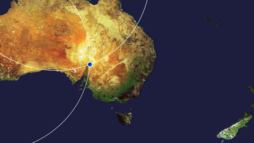 Video:
00:03:00
Video:
00:03:00
This edition of the Earth from Space programme features a false-colour image captured by Copernicus Sentinel-2 over the many colourful curves and folds of the Flinders Ranges – the largest mountain range in South Australia.
See also Flinders Ranges, South Australia to download the image.
Flinders Ranges, South Australia
31.7.2020 10:00 ESA Observing the Earth Image:
The many colourful curves and folds of the Flinders Ranges in South Australia are featured in this false-colour image captured by the Copernicus Sentinel-2 mission.
Image:
The many colourful curves and folds of the Flinders Ranges in South Australia are featured in this false-colour image captured by the Copernicus Sentinel-2 mission.
Výběrové řízení
31.7.2020 9:51 ČÚZK - předpisy a opatření Katastrální úřad pro Plzeňský kraj - Katastrální pracoviště Plzeň-město zveřejnil novou aktualitu: Ředitelka Katastrálního úřadu pro Plzeňský kraj vyhlašuje výběrové řízení na služební místo rada/odborný rada – vedoucí oddělení dokumentace KN – VOD10, Katastrální úřad pro Plzeňský kraj, Katastrální pracoviště Plzeň-město.Oznámení o vyhlášení výběrového řízení na služební místo rada/odborný rada – vedoucí oddělení dokume
31.7.2020 9:43 ČÚZK /Urady/Katastralni-urady/Katastralni-urady/Katastralni-urad-pro-Plzensky-kraj/Uredni-deska/Oznameni-a-jina-uredni-sdeleni/Volna-mista/DMS/Oznameni-o-vyhlaseni-vyberoveho-rizeni-na-sluzebniOznámení o vyhlášení výběrového řízení na služební místo rada/odborný rada – vedoucí oddělení dokume
31.7.2020 9:43 ČÚZK - předpisy a opatření Katastrální úřad pro Plzeňský kraj Katastrální pracoviště Plzeň-městovypisuje výběrové řízení na místo
Oznámení o vyhlášení výběrového řízení na služební místo rada/odborný rada – vedoucí oddělení dokumentace KN – VOD10
Oznámení o vyhlášení výběrového řízení na služební místo rada/odborný rada – vedoucí oddělení dokume
31.7.2020 9:43 ČÚZK - volná místa Katastrální úřad pro Plzeňský kraj Katastrální pracoviště Plzeň-město vypisuje výběrové řízení na místo Oznámení o vyhlášení výběrového řízení na služební místo rada/odborný rada – vedoucí oddělení dokumeTerénní cvičení z kartografie [Katedra aplikované geoinformatiky a kartografie, byTopic]
31.7.2020 9:05 Katedra aplikované geoinformatiky a kartografie Přf UK Terénní cvičení z kartografie pořádané katedrou aplikované geoinformatiky a kartografie proběhne v Nečtinách v termínu 6. - 11. 9. 2020.APGEO - APG má podporu i ve vedení Hospodářské komory
31.7.2020 2:00 Asociace podnikatelů v geomatice Všichni APG podporování kandidáti se dostali do vedení Hospodářské komory ČR, a to i hlasem naší asociace..INSPIRE téma Adresy (AD)
31.7.2020 2:00 Cenia - Katalog metadat ČR - INSPIRE Data odpovídají směrnici INSPIRE pro téma adresy (AD). Vychází především z projektu RÚIAN (Registr územní identifikace, adres a nemovitostí), který je součástí základních registrů České Republiky a obsahuje informace o územní identifikaci, adresách a nemovitostech. Data publikovaná v rámci INSPIRE obsahují pouze adresní místa a jejich komponenty, kterými jsou stát, obec, část obce, městský obvod v Praze (MOP), městký obvod/městská část (MO/MČ), ulice a pošta a to na území celé České Republiky. Obsahují rozvněž geometrii, která určuje definiční bod adresního místa. V datové sadě nění uvedeno 1,12%, t.j. 32941 adresních míst (k 27. 07. 2020), protože neobsahují definiční bod, podle kterého by je bylo možné prostorově určit. Více v zákoně č. 111/2009 Sb., o základních registrech a ve vyhlášce č. 359/2011 Sb., o základním registru územní identifikace, adres a nemovitostí v platných zněních a INSPIRE Data Specification on Addresses v 3.0.1 z 26.4.2010. Data ve formátu GML 3.2.1 jsou validní proti schématu XML pro INSPIRE téma Adresy ve verzi 4.0 a proti schématu pro prostorová data ELF ve verzi 1.0.INSPIRE téma Budovy (BU)
31.7.2020 2:00 Cenia - Katalog metadat ČR - INSPIRE Data odpovídají směrnici INSPIRE pro téma budovy (BU). Data pochází částečně z projektu RÚIAN (Registr územní identifikace, adres a nemovitostí), který je součástí základních registrů České Republiky a obsahuje informace o územní identifikaci, adresách a nemovitostech, a částečně z ISKN (Informační systém katastru nemovistostí). Zdrojem informací o budovách v ISKN je objekt Stavba, v RÚIAN je to Stavební objekt. Většina Staveb je zároveň Stavebními objekty, ale jsou případy, kdy tomu tak není. Kromě Budov datová sada obsahuje i části budov, které jsou pro potřeby INSPIRE vyjádřeny vchody z RÚIAN. Vchody obsahují informace o počtu podlaží, technickoekonomických atributech apod. Datová sada pokrývá celé území české republiky. V datové sadě není uvedeno 1,14%, t.j. 48193 budov (k 27. 07. 2020), protože neobsahují definiční bod ani polygon. Více v zákoně č. 111/2009 Sb., o základních registrech, ve vyhlášce č. 359/2011 Sb., o základním registru územní identifikace, adres a nemovitostí v platných zněních, v zákoně 256/2013 Sb., o katastru nemovitostí, v katastrální vyhlášce č. 357/2013 Sb. v platném znění a INSPIRE Data Specification on Buildings v 3.0 z 13.12.2013. Data ve formátu GML 3.2.1 jsou validní proti schématu XML pro INSPIRE téma Budovy ve verzi 4.0 a proti schématu pro prostorová data ELF ve verzi 1.0.INSPIRE téma Parcely (CP)
31.7.2020 2:00 Cenia - Katalog metadat ČR - INSPIRE Data odpovídají směrnici INSPIRE pro téma katastrální parcely (CP). Vychází z katastrální mapy, která je závazným státním mapovým dílem velkého měřítka, obsahuje body polohového bodového pole, polohopis a popis a může mít formu digitální mapy, analogové mapy nebo digitalizované mapy. Data publikovaná v rámci INSPIRE obsahují pouze katastrální území (pro celou Českou Republiku) a parcely a jejich hranice z území, kde je digitální mapa (k 27. 07. 2020 je to 96,90% území České republiky, t.j. 76 418,31km2). Více katastrální zákon 344/1992 SB., katastrální vyhláška č.26/2007 Sb. v platném znění a INSPIRE Data Specification on Cadastral Parcels v 3.0.1. Data ve formátu GML 3.2.1 jsou validní proti schématu XML pro INSPIRE téma Parcely ve verzi 4.0 a proti schématu pro prostorová data ELF ve verzi 1.0.Katastrální mapa v rastrové podobě poskytovaná v e-shopu
31.7.2020 2:00 Cenia - Katalog metadat ČR - INSPIRE Katastrální mapa v rastrové podobě je poskytována za úplatu a obsahuje analogovou mapu s kompletní kresbou. Analogová mapa pokrývá 2,94 % území České republiky, což je 2 317,17km2. Více katastrální vyhláška č.357/2013 Sb. v platném znění.Katastrální mapa ve formátech DGN a DXF poskytovaná v e-shopu
31.7.2020 2:00 Cenia - Katalog metadat ČR - INSPIRE Katastrální mapa je závazným státním mapovým dílem velkého měřítka, obsahuje body polohového bodového pole, polohopis a popis. Katastrální mapa ve vektorové podobě je poskytována zdarma ve formátu DGN a DXF a obsahuje prvky Digitální katastrální mapy (DKM) a Katastrální mapy digitalizované (KMD), tedy bodová pole, budovy, další prvky mapy, hranice parcel, katastrální hranice, parcely katastru nemovitostí, prvky orientační mapy a hranice věcného břemene. Z důvodu použití formátu DGN produkt neobsahuje značky na liniích a oblouky jsou nahrazeny lomenými čárami. Katastrální mapa ve vektorové podobě k 27. 07. 2020 pokrývá 96,90% území České republiky, t.j. 76 418,31km2. Více katastrální vyhláška č.357/2013 Sb. v platném znění.INSPIRE téma Rozšířené Parcely (CPX)
31.7.2020 2:00 Cenia - Katalog metadat ČR - INSPIRE Rozšíření má za cíl poskytovat katastrální mapu s obsahem podle vyhlášky ve vektorové podobě ve struktuře plně v souladu se strukturou danou směrnicí INSPIRE. Data rozšiřují směrnici INSPIRE pro téma katastrální parcely (CP) o věcná břemena, geodetické body, další prvky mapy, původní obloukovou geometrii a o parcely určené definičním bodem (ty pouze v oblastech s analogovou mapou). Vychází z katastrální mapy, která je závazným státním mapovým dílem velkého měřítka, obsahuje body polohového bodového pole, polohopis a popis a může mít formu digitální mapy, analogové mapy nebo digitalizované mapy. Publikovaná data obsahují katastrální území pro celou Českou Republiku, parcely a jejich hranice, věcná břemena, další prvky mapy a původní obloukovou geometrii z území, kde je digitální mapa (k 27. 07. 2020 je to 96,90% území České republiky, t.j. 76 418,31km2) a ve zbytku území katastrální parcely určené pouze definičním bodem (tedy bez hranic a polygonu). Katastrální parcely a hranice obsahují oproti datové sadě INSPIRE některé atributy navíc. Jedná se o typ hranice, způsob využití území, druh pozemku, vazbu na budovu a o mapové značky. Více katastrální zákon 344/1992 SB., katastrální vyhláška č.26/2007 Sb. v platném znění a INSPIRE Data Specification on Cadastral Parcels v 3.0.1. Data ve formátu GML 3.2.1 jsou validní proti schématu XML pro Rozšířené Parcely (CPX) ve verzi 4.0.Maxar Congratulates NASA on Launch of Perseverance Rover, Featuring Next-Generation Space Robotics
30.7.2020 22:43 GISCafe.com Webcasts-Webinars Maxar contributes a sixth robotic arm for Mars explorationWESTMINSTER, Colo. — (BUSINESS WIRE) — July 30, 2020 —
Maxar …
Textron Reports Second Quarter 2020 Results
30.7.2020 17:50 GISCafe.com Webcasts-Webinars Cash flow from operations of $245 millionBell revenue up 7% from prior year, operating margin of 14.4%
Textron Systems revenue up 6% from prior …
Pitney Bowes Announces Second Quarter 2020 Financial Results
30.7.2020 17:50 GISCafe.com Webcasts-Webinars STAMFORD, Conn. — (BUSINESS WIRE) — July 30, 2020 —Pitney Bowes Inc. (NYSE: PBI), a global technology company that provides …
Velodyne Lidar Sensors Power Emesent’s Hovermap to Fly Beyond the Visual Line of Sight
30.7.2020 17:50 GISCafe.com Webcasts-Webinars Emesent’s AL2 for Hovermap Leverages Velodyne Lidar to Access the InaccessibleSAN JOSE, Calif. — (BUSINESS WIRE) — July 30, 2020 …
Urban-Air Port Ltd and Hyundai Air Mobility Partner to Develop Urban Air Mobility Infrastructure
30.7.2020 17:50 GISCafe.com Webcasts-Webinars Collaboration aims to create smart mobility solutions that puts people first, connects communities and generates shared value.LONDON, July 30, 2020 …
Bentley Systems and NoteVault advance scope of construction digital twins
30.7.2020 17:33 Bentley SystemsPress Coverage
Power Engineering international, UK
Read the articleKonference GIS Esri v ČR bude online
30.7.2020 17:27 Česká kartografická společnost S ohledem na možnost, že se v době konání konference mohou vrátit aktivní opatření proti šíření COVID-19, rozhodli se organizátoři letošní konferenci GIS Esri v ČR uspořádat virtuální formou. Osobní setkání ve virtuálním prostředí zprostředkovat nelze, ale organizátoři ze společnosti ARCDATA PRAHA slibují, že udělali vše pro to, aby zachovali všechny nejdůležitější části programu. Více […]Bentley Systems Announces the Acquisition of NoteVault
30.7.2020 17:26 Bentley SystemsPress Coverage
Manufacturing and Engineering Magazine, UK
Read the articleBentley adds NoteVault to strengthen digital twin capabilities
30.7.2020 17:16 Bentley SystemsPress Coverage
BIM+, UK
Read the article20200730-VŘ Metodik/metodička bezpečnosti
30.7.2020 17:14 ČÚZK - předpisy a opatření Český úřad zeměměřický a katastrální zveřejnil novou aktualitu: Oznámení o vyhlášení výběrového řízení na obsazení služebního místa odborný rada - Metodik/metodička bezpečnosti.20200730-VŘ Metodik/metodička bezpečnosti
30.7.2020 17:14 ČÚZK /Aktuality-resort/2020/20200730-VR-Metodik-metodicka-bezpecnostiWorking from home: AEC firms under Covid-19 lockdown
30.7.2020 17:12 Bentley SystemsPress Coverage
AEC Magazine, UK
Read the articleAdvancing the scope of construction Digital Twins
30.7.2020 17:07 Bentley SystemsPress Coverage
Electronic Specifier, UK
Read the articleBentley waives ProjectWise 365 subscription fees until September 30th
30.7.2020 17:02 Bentley SystemsPress Coverage
CAD User, UK
Read the article20200730-VŘ Správce RÚIAN
30.7.2020 16:57 ČÚZK - předpisy a opatření Český úřad zeměměřický a katastrální zveřejnil novou aktualitu: Oznámení o vyhlášení výběrového řízení na obsazení služebního místa odborný rada - Správce RÚIAN.Foth Uses Collaborative Digital Engineering to Deliver Road Infrastructure Project
30.7.2020 16:52 Bentley SystemsPress Coverage
World Highways, UK
Read the articleStudent GÚ Damián Hruban v Magazínu M
30.7.2020 14:14 Geografický ústav MUStudent Geografického ústavu Damián Hruban popisuje v Magazínu M své zážitky coby dobrovolník při uprchlické krizi.
Esri byla v nezávislé analýze označena za technologického leadera v oblasti Climate Risk Analytics
30.7.2020 12:00 ARCDATAPo nedávném úspěchu v oblasti Location Intelligence získala Esri od nezávislé analytické společnosti Forrester další hodnocení Leader, tentokrát na poli Climate Risk Analytics.
Hodnoceno bylo celkem osm nejvýznamnějších dodavatelů, u kterých byla posuzována celá řada ukazatelů. Jmenovitě se jednalo o proces sběru a export dat, nástroje na jejich zpracování a následnou vizualizaci. Posuzována byla také dlouhodobá vize společnosti a její plánovaný přístup k dané problematice.
Status Leadera Esri získala především díky svým pokročilým nástrojům pro práci s daty, jejich analýzu a následnou vizualizaci. Jak ale řekl prezident společnosti Esri, Jack Dangermond, jedná se i o výsledek dlouhodobé systematické práce Esri v oblasti managementu životního prostředí.
Zpráva od společnosti The Forrester Wave™ je dostupná na webových stránkách Esri.

Zveřejnění obsahu informací poskytnutých na žádost dle zákona č. 106/1999 Sb. za rok 20
30.7.2020 10:57 ČÚZK - předpisy a opatření Katastrální úřad pro Karlovarský krajzveřejňuje obsah informace poskytnutých na žádost dle zákona č. 106/1999 Sb. za rok
2020
Zveřejnění obsahu informací poskytnutých na žádost dle zákona č. 106/1999 Sb. za rok 20
30.7.2020 10:57 ČÚZK /Urady/Katastralni-urady/Katastralni-urady/Katastralni-urad-pro-Karlovarsky-kraj/Casto-hledane-informace/Poskytovani-informaci-106-1999-Sb/Zverejneni-obsahu-informaci-poskytnutych-na-za-(1)/Zverejneni-obsahu-informaci-poskytnutych-na-za-(2)Historická ortofotomapa na Národním geoportálu INSPIRE
30.7.2020 10:39 CENIA - národní geoportál INSPIRE Vážení uživatelé, dovolujeme si Vás upozornit, že k 30.6.2020 byl ukončen přístup k aplikaci https://kontaminace.cenia.cz, a to z důvodu zastarání technického řešení a ukončení podpory některých softwarových komponent (Adobe Flash). Vrstva historického ortofota ČR z 50.let 20.st. je nadále dostupná z Národního geoportálu INSPIRE na tomto odkazu. Pro efektivní práci s mapovým oknem Vám doporučujeme...referent KN – návrh zápisu, kontrola a zplatnění v PO VI.
30.7.2020 9:09 ČÚZK - volná místa Katastrální úřad pro hlavní město Prahu vypisuje výběrové řízení na místo referent KN – návrh zápisu, kontrola a zplatnění v PO VI.referent KN – návrh zápisu, kontrola a zplatnění v PO VI.
30.7.2020 9:09 ČÚZK - předpisy a opatření Katastrální úřad pro hlavní město Prahuvypisuje výběrové řízení na místo
referent KN – návrh zápisu, kontrola a zplatnění v PO VI.
referent KN – návrh zápisu, kontrola a zplatnění v PO VI.
30.7.2020 9:09 ČÚZK /Urady/Katastralni-urady/Katastralni-urady/Katastralni-urad-pro-hlavni-mesto-Prahu/Uredni-deska/Oznameni-a-jina-uredni-sdeleni/Volna-mista/DMS/referent-KN-–-navrh-zapisu,-kontrola-a-zplatneni-v20200730-VŘ Asistent/Asistentka
30.7.2020 8:47 ČÚZK /Aktuality-resort/2020/20200730-VR-Asistent-Asistentka20200730-VŘ Asistent/Asistentka
30.7.2020 8:47 ČÚZK - předpisy a opatření Český úřad zeměměřický a katastrální zveřejnil novou aktualitu: Oznámení o vyhlášení výběrového řízení na obsazení pracovního místa - Asistent/Asistentka.kancelářská technika a přívěsný vozík
30.7.2020 8:43 ČÚZK - předpisy a opatřeníKatastrální úřad pro Vysočinu nabízí nepotřebný majetek k odkupu. Jedná se o
kancelářská technika a přívěsný vozík
kancelářská technika a přívěsný vozík
30.7.2020 8:43 ČÚZK /Urady/Katastralni-urady/Katastralni-urady/Katastralni-urad-pro-Vysocinu/Nabidky-majetku/kancelarska-technika-a-privesny-vozikAsistent/Asistentka
30.7.2020 8:40 ČÚZK /Urady/Cesky-urad-zememericky-a-katastralni/Volna-mista/DMS/Asistent-AsistentkaAsistent/Asistentka
30.7.2020 8:40 ČÚZK - předpisy a opatření Český úřad zeměměřický a katastrálnívypisuje výběrové řízení na místo
Asistent/Asistentka
Asistent/Asistentka
30.7.2020 8:40 ČÚZK - volná místa Český úřad zeměměřický a katastrální vypisuje výběrové řízení na místo Asistent/AsistentkaCall – professorship in Geoinformatics – Institute for Geoinformatics, Münster, Germany
30.7.2020 7:29 Professorship (W2) in Geoinformatics for sustainable development starting at the earliest possible date. Who are we looking for? Applicants should have an outstanding PhD in Geoinformatics or a related field. They should have a proven track record (peer reviewed publications, international network, successful research funding acquisitions) in at least one innovative area in geoinformatics (GI) […]Post-doc position in the MIning MUlti-source and MUlti-modal geo-referenced information (MIMU) project
30.7.2020 7:27 http://www.eracareers.pt/opportunities/index.aspx?task=global&jobId=125792 Innovative geographic knowledge discovery is becoming increasingly possible through the analysis of large-scale data, for instance made available by Earth observation projects leveraging satellites and remote-sensing, provided by ground-level sensors, or given as volunteered geographical information (e.g., geo-referenced multimedia contents posted online on social media platforms). However, problems that involve combining remotely-sensed data with […]AEC Next and SPAR 3D announce Call for Speakers for co-located 2021 event in Denver, CO
30.7.2020 0:18 GISCafe.com Webcasts-Webinars Denver, CO (USA) July 29, 2020 - The AEC Next Technology Expo + Conference and the SPAR 3D Expo & Conference, taking place in Denver, CO, March …Hexagon to Support Maryland’s Harford County with Records Management Upgrade
29.7.2020 21:09 Hexagon Safety & Infrastructure New records management system will better equip first responders to manage incidents, identify trends and analyze dataHexagon to Support Maryland’s Harford County with Records Management Upgrade
29.7.2020 21:09 Hexagon Safety & Infrastructure New countywide records management system (RMS) will better equip first responders to manage incidents, identify trends and analyze law enforcement data in communities across the county.Hexagon to Support Maryland’s Harford County with Records Management Upgrade
29.7.2020 21:09 Hexagon Safety & InfrastructureHexagon to Support Maryland’s Harford County with Records Management Upgrade
29.7.2020 21:09 Hexagon Safety & Infrastructure New records management system will better equip first responders to manage incidents, identify trends and analyze dataSteve Anderson Named to Esri’s Partner Advisory Council
29.7.2020 20:32 GISCafe.com Webcasts-Webinars Wethersfield, CT (July 29, 2020) - VHB is pleased to announce the nomination and acceptance of Steve Anderson to Esri's Partner Advisory Council …StoreDot Demonstrates World's First 5-Minute Charge of a Commercial Drone, Making Continuous & Fully-Autonomous Drone Delivery a Reality
29.7.2020 18:02 GISCafe.com Webcasts-Webinars TEL AVIV, Israel, July 29, 2020 — (PRNewswire) — Twelve months ago, ultra-fast charging (UFC) pioneer, StoreDot, achieved a world first …Symboly Häfele pro TurboCAD/DAEX
29.7.2020 16:01 ŠPINAR - software Ukázka použití knihovny Häfele v programu TurboCAD/DAEX s výstupy.Symboly Häfele pro TurboCAD/DAEX
29.7.2020 16:01 ŠPINAR - softwareUkázka použití knihovny Häfele v programu TurboCAD/DAEX s výstupy.
The post Symboly Häfele pro TurboCAD/DAEX appeared first on ŠPINAR – software.
Garmin® reports strong second quarter 2020 revenue and income during the COVID-19 pandemic
29.7.2020 15:59 GISCafe.com Webcasts-Webinars SCHAFFHAUSEN, Switzerland — (BUSINESS WIRE) — July 29, 2020 —Garmin Ltd. (Nasdaq: GRMN – News) today announced results for the …
Skyports Partners with Robotic Skies to Develop a UAS Maintenance Programme for Drone Delivery and Beyond
29.7.2020 15:59 GISCafe.com Webcasts-Webinars Aviation-grade maintenance services are vital to full-scale, permanent commercial drone delivery operations.LONDON, July 29, 2020 — …
TraceAir Expands Its Advisory Board
29.7.2020 15:59 GISCafe.com Webcasts-Webinars TraceAir Technologies is excited to announce that construction industry expert, Steve Dell'Orto, has joined TraceAir's Advisory Board.REDWOOD CITY, …
Woolpert Hired to Research and Develop Airfield Design Guidelines for Large UAS
29.7.2020 15:59 GISCafe.com Webcasts-Webinars The firm will evaluate the safety, capacity and logistical challenges of introducing drones into airport operations and provide planning standards …Autodesk and Aurigo Software Combine the Power of their Products to Drive Productivity Across Capital Projects
29.7.2020 15:59 GISCafe.com Webcasts-Webinars Integration between Autodesk Construction Cloud and Aurigo Masterworks will strengthen collaboration between capital owners and contractorsAUSTIN, …
Materiály Kronospan pro TurboCAD/DAEX
29.7.2020 15:46 ŠPINAR - software Ukázka použití knihovny nových materiálů Kronospan (Trends 2020-2021) v programu TurboCAD/DAEX.Materiály Kronospan pro TurboCAD/DAEX
29.7.2020 15:46 ŠPINAR - softwareUkázka použití knihovny nových materiálů Kronospan (Trends 2020-2021) v programu TurboCAD/DAEX.
The post Materiály Kronospan pro TurboCAD/DAEX appeared first on ŠPINAR – software.
Digital Twins The heart of the digital transformation
29.7.2020 15:40 Bentley SystemsPress Coverage
Hydrocarbon Engineering, UK
Read the articleVirtual Build spotlights IoT updates and rollouts
29.7.2020 15:37 Bentley SystemsPress Coverage
Microsoft, USA
Read the article“Be creative and bold!” webinar attendees told
29.7.2020 15:34 Bentley SystemsPress Coverage
Infrastructure Intelligence, UK
Read the article3D BIM processes used in design of Qatar Office Tower
29.7.2020 15:32 Bentley SystemsPress Coverage
International Construction, UK
Read the articleBentley Systems joins Digital Twin Consortium
29.7.2020 15:23 Bentley SystemsPress Coverage
PBC Today, UK
Read the articleConstruction transformed in 2020
29.7.2020 15:15 Bentley SystemsPress Coverage
Graphic Speak, USA
Read the articleCovid-19 | Managing pedestrian flow creates new engineering challenge
29.7.2020 15:12 Bentley SystemsPress Coverage
New Civil Engineer, UK
Read the articleBentley Systems Year in Infrastructure 2020 conference goes digital
29.7.2020 15:09 Bentley SystemsPress Coverage
BIM Today, UK
Read the articleBentley Systems acquires voice-based site automation developer
29.7.2020 15:06 Bentley SystemsPress Coverage
AEC Magazine, UK
Read the articleBentley brings construction elements digital twin development group
29.7.2020 15:02 Bentley SystemsPress Coverage
New Civil Engineer, UK
Read the articleNaše služby zachraňovaly obce při padnemii
29.7.2020 14:09 Hrdlička V obci Tetín byly využity aplikace STAVEE a MawisPhoto na elektronizaci stavebnictví.Naše služby zachraňovaly obce při padnemii
29.7.2020 14:01 Hrdlička V důsledku pandemie proběhla elektronizace stavebnictví v obci Tetín.Zúčastníme se akce "Do práce na kole 2020"
29.7.2020 13:56 Hrdlička Podporujeme naše zaměstnance ve sportovních aktivitách.Využití BIM při rekonstrukci nádraží Čachovice
29.7.2020 13:53 Hrdlička Rekonstrukce kolejiště a nástupišť v nádraží Čachovice spadá do pilotních projektů využití...Jak efektivně zadržet vodu v krajině?
29.7.2020 13:51 Hrdlička V týdeníku Echo24 probíráme situaci pozemkových úprav.Geodeti v terénu jako kaskadéři
29.7.2020 13:49 Hrdlička Práce v terénu není jednoduchá, a o tom se přesvědčují i naši geodeti.Oznameni_o_vyhl_vyberoveho_rizeni_NZK1504_KP-Tachov
29.7.2020 13:29 ČÚZK - předpisy a opatření Katastrální úřad pro Plzeňský kraj Katastrální pracoviště Tachovvypisuje výběrové řízení na místo
Oznameni_o_vyhl_vyberoveho_rizeni_NZK1504_KP-Tachov
Oznameni_o_vyhl_vyberoveho_rizeni_NZK1504_KP-Tachov
29.7.2020 13:29 ČÚZK - volná místa Katastrální úřad pro Plzeňský kraj Katastrální pracoviště Tachov vypisuje výběrové řízení na místo Oznameni_o_vyhl_vyberoveho_rizeni_NZK1504_KP-TachovOznameni_o_vyhl_vyberoveho_rizeni_NZK1504_KP-Tachov
29.7.2020 13:29 ČÚZK /Urady/Katastralni-urady/Katastralni-urady/Katastralni-urad-pro-Plzensky-kraj/Uredni-deska/Oznameni-a-jina-uredni-sdeleni/Volna-mista/DMS/Oznameni_o_vyhl_vyberoveho_rizeni_NZK1504_KP-TachoOznameni_o_vyhl_vyberoveho_rizeni_NZK1504_KP-Tachov
29.7.2020 13:29 ČÚZK - předpisy a opatření Katastrální úřad pro Plzeňský kraj Katastrální pracoviště Tachovvypisuje výběrové řízení na místo
Odborný/vrchní referent - návrh zápisu v katastru – NZK1504, oddělení aktualizace a dokumentace KN, KP Tachov
New Space satellite pinpoints industrial methane emissions
29.7.2020 12:40 ESA Observing the Earth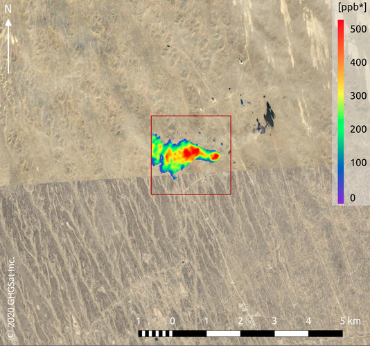
Methane may not be as abundant in the atmosphere as carbon dioxide, but with a global warming potential many times greater than carbon dioxide, monitoring and controlling industrial emissions of this potent gas is imperative to helping combat climate change. GHGSat is a New Space initiative that draws on Copernicus Sentinel-5P data for mapping methane hotspots – and its Claire satellite has now collected more than 60 000 methane measurements of industrial facilities around the world.
New Space satellite pinpoints industrial emissions of methane
29.7.2020 12:40 ESA Observing the Earth
Methane may not be as abundant in the atmosphere as carbon dioxide, but with a global warming potential many times greater than carbon dioxide, monitoring and controlling industrial emissions of this potent gas is imperative to helping combat climate change. GHGSat is a New Space initiative that draws on Copernicus Sentinel-5P data for mapping methane hotspots – and its Claire satellite has now collected more than 60 000 methane measurements of industrial facilities around the world.