


![]()

zprávy
zdroje zpráv:Textron Reports Second Quarter 2020 Results
30.7.2020 17:50 GISCafe.com Webcasts-Webinars Cash flow from operations of $245 millionBell revenue up 7% from prior year, operating margin of 14.4%
Textron Systems revenue up 6% from prior …
Pitney Bowes Announces Second Quarter 2020 Financial Results
30.7.2020 17:50 GISCafe.com Webcasts-Webinars STAMFORD, Conn. — (BUSINESS WIRE) — July 30, 2020 —Pitney Bowes Inc. (NYSE: PBI), a global technology company that provides …
Velodyne Lidar Sensors Power Emesent’s Hovermap to Fly Beyond the Visual Line of Sight
30.7.2020 17:50 GISCafe.com Webcasts-Webinars Emesent’s AL2 for Hovermap Leverages Velodyne Lidar to Access the InaccessibleSAN JOSE, Calif. — (BUSINESS WIRE) — July 30, 2020 …
Urban-Air Port Ltd and Hyundai Air Mobility Partner to Develop Urban Air Mobility Infrastructure
30.7.2020 17:50 GISCafe.com Webcasts-Webinars Collaboration aims to create smart mobility solutions that puts people first, connects communities and generates shared value.LONDON, July 30, 2020 …
Bentley Systems and NoteVault advance scope of construction digital twins
30.7.2020 17:33 Bentley SystemsPress Coverage
Power Engineering international, UK
Read the articleKonference GIS Esri v ČR bude online
30.7.2020 17:27 Česká kartografická společnost S ohledem na možnost, že se v době konání konference mohou vrátit aktivní opatření proti šíření COVID-19, rozhodli se organizátoři letošní konferenci GIS Esri v ČR uspořádat virtuální formou. Osobní setkání ve virtuálním prostředí zprostředkovat nelze, ale organizátoři ze společnosti ARCDATA PRAHA slibují, že udělali vše pro to, aby zachovali všechny nejdůležitější části programu. Více […]Bentley Systems Announces the Acquisition of NoteVault
30.7.2020 17:26 Bentley SystemsPress Coverage
Manufacturing and Engineering Magazine, UK
Read the articleBentley adds NoteVault to strengthen digital twin capabilities
30.7.2020 17:16 Bentley SystemsPress Coverage
BIM+, UK
Read the article20200730-VŘ Metodik/metodička bezpečnosti
30.7.2020 17:14 ČÚZK - předpisy a opatření Český úřad zeměměřický a katastrální zveřejnil novou aktualitu: Oznámení o vyhlášení výběrového řízení na obsazení služebního místa odborný rada - Metodik/metodička bezpečnosti.20200730-VŘ Metodik/metodička bezpečnosti
30.7.2020 17:14 ČÚZK /Aktuality-resort/2020/20200730-VR-Metodik-metodicka-bezpecnostiWorking from home: AEC firms under Covid-19 lockdown
30.7.2020 17:12 Bentley SystemsPress Coverage
AEC Magazine, UK
Read the articleAdvancing the scope of construction Digital Twins
30.7.2020 17:07 Bentley SystemsPress Coverage
Electronic Specifier, UK
Read the articleBentley waives ProjectWise 365 subscription fees until September 30th
30.7.2020 17:02 Bentley SystemsPress Coverage
CAD User, UK
Read the article20200730-VŘ Správce RÚIAN
30.7.2020 16:57 ČÚZK - předpisy a opatření Český úřad zeměměřický a katastrální zveřejnil novou aktualitu: Oznámení o vyhlášení výběrového řízení na obsazení služebního místa odborný rada - Správce RÚIAN.Foth Uses Collaborative Digital Engineering to Deliver Road Infrastructure Project
30.7.2020 16:52 Bentley SystemsPress Coverage
World Highways, UK
Read the articleStudent GÚ Damián Hruban v Magazínu M
30.7.2020 14:14 Geografický ústav MUStudent Geografického ústavu Damián Hruban popisuje v Magazínu M své zážitky coby dobrovolník při uprchlické krizi.
Esri byla v nezávislé analýze označena za technologického leadera v oblasti Climate Risk Analytics
30.7.2020 12:00 ARCDATAPo nedávném úspěchu v oblasti Location Intelligence získala Esri od nezávislé analytické společnosti Forrester další hodnocení Leader, tentokrát na poli Climate Risk Analytics.
Hodnoceno bylo celkem osm nejvýznamnějších dodavatelů, u kterých byla posuzována celá řada ukazatelů. Jmenovitě se jednalo o proces sběru a export dat, nástroje na jejich zpracování a následnou vizualizaci. Posuzována byla také dlouhodobá vize společnosti a její plánovaný přístup k dané problematice.
Status Leadera Esri získala především díky svým pokročilým nástrojům pro práci s daty, jejich analýzu a následnou vizualizaci. Jak ale řekl prezident společnosti Esri, Jack Dangermond, jedná se i o výsledek dlouhodobé systematické práce Esri v oblasti managementu životního prostředí.
Zpráva od společnosti The Forrester Wave™ je dostupná na webových stránkách Esri.

Zveřejnění obsahu informací poskytnutých na žádost dle zákona č. 106/1999 Sb. za rok 20
30.7.2020 10:57 ČÚZK - předpisy a opatření Katastrální úřad pro Karlovarský krajzveřejňuje obsah informace poskytnutých na žádost dle zákona č. 106/1999 Sb. za rok
2020
Zveřejnění obsahu informací poskytnutých na žádost dle zákona č. 106/1999 Sb. za rok 20
30.7.2020 10:57 ČÚZK /Urady/Katastralni-urady/Katastralni-urady/Katastralni-urad-pro-Karlovarsky-kraj/Casto-hledane-informace/Poskytovani-informaci-106-1999-Sb/Zverejneni-obsahu-informaci-poskytnutych-na-za-(1)/Zverejneni-obsahu-informaci-poskytnutych-na-za-(2)Historická ortofotomapa na Národním geoportálu INSPIRE
30.7.2020 10:39 CENIA - národní geoportál INSPIRE Vážení uživatelé, dovolujeme si Vás upozornit, že k 30.6.2020 byl ukončen přístup k aplikaci https://kontaminace.cenia.cz, a to z důvodu zastarání technického řešení a ukončení podpory některých softwarových komponent (Adobe Flash). Vrstva historického ortofota ČR z 50.let 20.st. je nadále dostupná z Národního geoportálu INSPIRE na tomto odkazu. Pro efektivní práci s mapovým oknem Vám doporučujeme...referent KN – návrh zápisu, kontrola a zplatnění v PO VI.
30.7.2020 9:09 ČÚZK - volná místa Katastrální úřad pro hlavní město Prahu vypisuje výběrové řízení na místo referent KN – návrh zápisu, kontrola a zplatnění v PO VI.referent KN – návrh zápisu, kontrola a zplatnění v PO VI.
30.7.2020 9:09 ČÚZK - předpisy a opatření Katastrální úřad pro hlavní město Prahuvypisuje výběrové řízení na místo
referent KN – návrh zápisu, kontrola a zplatnění v PO VI.
referent KN – návrh zápisu, kontrola a zplatnění v PO VI.
30.7.2020 9:09 ČÚZK /Urady/Katastralni-urady/Katastralni-urady/Katastralni-urad-pro-hlavni-mesto-Prahu/Uredni-deska/Oznameni-a-jina-uredni-sdeleni/Volna-mista/DMS/referent-KN-–-navrh-zapisu,-kontrola-a-zplatneni-v20200730-VŘ Asistent/Asistentka
30.7.2020 8:47 ČÚZK /Aktuality-resort/2020/20200730-VR-Asistent-Asistentka20200730-VŘ Asistent/Asistentka
30.7.2020 8:47 ČÚZK - předpisy a opatření Český úřad zeměměřický a katastrální zveřejnil novou aktualitu: Oznámení o vyhlášení výběrového řízení na obsazení pracovního místa - Asistent/Asistentka.kancelářská technika a přívěsný vozík
30.7.2020 8:43 ČÚZK - předpisy a opatřeníKatastrální úřad pro Vysočinu nabízí nepotřebný majetek k odkupu. Jedná se o
kancelářská technika a přívěsný vozík
kancelářská technika a přívěsný vozík
30.7.2020 8:43 ČÚZK /Urady/Katastralni-urady/Katastralni-urady/Katastralni-urad-pro-Vysocinu/Nabidky-majetku/kancelarska-technika-a-privesny-vozikAsistent/Asistentka
30.7.2020 8:40 ČÚZK /Urady/Cesky-urad-zememericky-a-katastralni/Volna-mista/DMS/Asistent-AsistentkaAsistent/Asistentka
30.7.2020 8:40 ČÚZK - předpisy a opatření Český úřad zeměměřický a katastrálnívypisuje výběrové řízení na místo
Asistent/Asistentka
Asistent/Asistentka
30.7.2020 8:40 ČÚZK - volná místa Český úřad zeměměřický a katastrální vypisuje výběrové řízení na místo Asistent/AsistentkaCall – professorship in Geoinformatics – Institute for Geoinformatics, Münster, Germany
30.7.2020 7:29 Professorship (W2) in Geoinformatics for sustainable development starting at the earliest possible date. Who are we looking for? Applicants should have an outstanding PhD in Geoinformatics or a related field. They should have a proven track record (peer reviewed publications, international network, successful research funding acquisitions) in at least one innovative area in geoinformatics (GI) […]Post-doc position in the MIning MUlti-source and MUlti-modal geo-referenced information (MIMU) project
30.7.2020 7:27 http://www.eracareers.pt/opportunities/index.aspx?task=global&jobId=125792 Innovative geographic knowledge discovery is becoming increasingly possible through the analysis of large-scale data, for instance made available by Earth observation projects leveraging satellites and remote-sensing, provided by ground-level sensors, or given as volunteered geographical information (e.g., geo-referenced multimedia contents posted online on social media platforms). However, problems that involve combining remotely-sensed data with […]AEC Next and SPAR 3D announce Call for Speakers for co-located 2021 event in Denver, CO
30.7.2020 0:18 GISCafe.com Webcasts-Webinars Denver, CO (USA) July 29, 2020 - The AEC Next Technology Expo + Conference and the SPAR 3D Expo & Conference, taking place in Denver, CO, March …Hexagon to Support Maryland’s Harford County with Records Management Upgrade
29.7.2020 21:09 Hexagon Safety & Infrastructure New records management system will better equip first responders to manage incidents, identify trends and analyze dataHexagon to Support Maryland’s Harford County with Records Management Upgrade
29.7.2020 21:09 Hexagon Safety & Infrastructure New countywide records management system (RMS) will better equip first responders to manage incidents, identify trends and analyze law enforcement data in communities across the county.Hexagon to Support Maryland’s Harford County with Records Management Upgrade
29.7.2020 21:09 Hexagon Safety & InfrastructureHexagon to Support Maryland’s Harford County with Records Management Upgrade
29.7.2020 21:09 Hexagon Safety & Infrastructure New records management system will better equip first responders to manage incidents, identify trends and analyze dataSteve Anderson Named to Esri’s Partner Advisory Council
29.7.2020 20:32 GISCafe.com Webcasts-Webinars Wethersfield, CT (July 29, 2020) - VHB is pleased to announce the nomination and acceptance of Steve Anderson to Esri's Partner Advisory Council …StoreDot Demonstrates World's First 5-Minute Charge of a Commercial Drone, Making Continuous & Fully-Autonomous Drone Delivery a Reality
29.7.2020 18:02 GISCafe.com Webcasts-Webinars TEL AVIV, Israel, July 29, 2020 — (PRNewswire) — Twelve months ago, ultra-fast charging (UFC) pioneer, StoreDot, achieved a world first …Symboly Häfele pro TurboCAD/DAEX
29.7.2020 16:01 ŠPINAR - software Ukázka použití knihovny Häfele v programu TurboCAD/DAEX s výstupy.Symboly Häfele pro TurboCAD/DAEX
29.7.2020 16:01 ŠPINAR - softwareUkázka použití knihovny Häfele v programu TurboCAD/DAEX s výstupy.
The post Symboly Häfele pro TurboCAD/DAEX appeared first on ŠPINAR – software.
Garmin® reports strong second quarter 2020 revenue and income during the COVID-19 pandemic
29.7.2020 15:59 GISCafe.com Webcasts-Webinars SCHAFFHAUSEN, Switzerland — (BUSINESS WIRE) — July 29, 2020 —Garmin Ltd. (Nasdaq: GRMN – News) today announced results for the …
Skyports Partners with Robotic Skies to Develop a UAS Maintenance Programme for Drone Delivery and Beyond
29.7.2020 15:59 GISCafe.com Webcasts-Webinars Aviation-grade maintenance services are vital to full-scale, permanent commercial drone delivery operations.LONDON, July 29, 2020 — …
TraceAir Expands Its Advisory Board
29.7.2020 15:59 GISCafe.com Webcasts-Webinars TraceAir Technologies is excited to announce that construction industry expert, Steve Dell'Orto, has joined TraceAir's Advisory Board.REDWOOD CITY, …
Woolpert Hired to Research and Develop Airfield Design Guidelines for Large UAS
29.7.2020 15:59 GISCafe.com Webcasts-Webinars The firm will evaluate the safety, capacity and logistical challenges of introducing drones into airport operations and provide planning standards …Autodesk and Aurigo Software Combine the Power of their Products to Drive Productivity Across Capital Projects
29.7.2020 15:59 GISCafe.com Webcasts-Webinars Integration between Autodesk Construction Cloud and Aurigo Masterworks will strengthen collaboration between capital owners and contractorsAUSTIN, …
Materiály Kronospan pro TurboCAD/DAEX
29.7.2020 15:46 ŠPINAR - software Ukázka použití knihovny nových materiálů Kronospan (Trends 2020-2021) v programu TurboCAD/DAEX.Materiály Kronospan pro TurboCAD/DAEX
29.7.2020 15:46 ŠPINAR - softwareUkázka použití knihovny nových materiálů Kronospan (Trends 2020-2021) v programu TurboCAD/DAEX.
The post Materiály Kronospan pro TurboCAD/DAEX appeared first on ŠPINAR – software.
Digital Twins The heart of the digital transformation
29.7.2020 15:40 Bentley SystemsPress Coverage
Hydrocarbon Engineering, UK
Read the articleVirtual Build spotlights IoT updates and rollouts
29.7.2020 15:37 Bentley SystemsPress Coverage
Microsoft, USA
Read the article“Be creative and bold!” webinar attendees told
29.7.2020 15:34 Bentley SystemsPress Coverage
Infrastructure Intelligence, UK
Read the article3D BIM processes used in design of Qatar Office Tower
29.7.2020 15:32 Bentley SystemsPress Coverage
International Construction, UK
Read the articleBentley Systems joins Digital Twin Consortium
29.7.2020 15:23 Bentley SystemsPress Coverage
PBC Today, UK
Read the articleConstruction transformed in 2020
29.7.2020 15:15 Bentley SystemsPress Coverage
Graphic Speak, USA
Read the articleCovid-19 | Managing pedestrian flow creates new engineering challenge
29.7.2020 15:12 Bentley SystemsPress Coverage
New Civil Engineer, UK
Read the articleBentley Systems Year in Infrastructure 2020 conference goes digital
29.7.2020 15:09 Bentley SystemsPress Coverage
BIM Today, UK
Read the articleBentley Systems acquires voice-based site automation developer
29.7.2020 15:06 Bentley SystemsPress Coverage
AEC Magazine, UK
Read the articleBentley brings construction elements digital twin development group
29.7.2020 15:02 Bentley SystemsPress Coverage
New Civil Engineer, UK
Read the articleNaše služby zachraňovaly obce při padnemii
29.7.2020 14:09 Hrdlička V obci Tetín byly využity aplikace STAVEE a MawisPhoto na elektronizaci stavebnictví.Naše služby zachraňovaly obce při padnemii
29.7.2020 14:01 Hrdlička V důsledku pandemie proběhla elektronizace stavebnictví v obci Tetín.Zúčastníme se akce "Do práce na kole 2020"
29.7.2020 13:56 Hrdlička Podporujeme naše zaměstnance ve sportovních aktivitách.Využití BIM při rekonstrukci nádraží Čachovice
29.7.2020 13:53 Hrdlička Rekonstrukce kolejiště a nástupišť v nádraží Čachovice spadá do pilotních projektů využití...Jak efektivně zadržet vodu v krajině?
29.7.2020 13:51 Hrdlička V týdeníku Echo24 probíráme situaci pozemkových úprav.Geodeti v terénu jako kaskadéři
29.7.2020 13:49 Hrdlička Práce v terénu není jednoduchá, a o tom se přesvědčují i naši geodeti.Oznameni_o_vyhl_vyberoveho_rizeni_NZK1504_KP-Tachov
29.7.2020 13:29 ČÚZK - předpisy a opatření Katastrální úřad pro Plzeňský kraj Katastrální pracoviště Tachovvypisuje výběrové řízení na místo
Oznameni_o_vyhl_vyberoveho_rizeni_NZK1504_KP-Tachov
Oznameni_o_vyhl_vyberoveho_rizeni_NZK1504_KP-Tachov
29.7.2020 13:29 ČÚZK - volná místa Katastrální úřad pro Plzeňský kraj Katastrální pracoviště Tachov vypisuje výběrové řízení na místo Oznameni_o_vyhl_vyberoveho_rizeni_NZK1504_KP-TachovOznameni_o_vyhl_vyberoveho_rizeni_NZK1504_KP-Tachov
29.7.2020 13:29 ČÚZK /Urady/Katastralni-urady/Katastralni-urady/Katastralni-urad-pro-Plzensky-kraj/Uredni-deska/Oznameni-a-jina-uredni-sdeleni/Volna-mista/DMS/Oznameni_o_vyhl_vyberoveho_rizeni_NZK1504_KP-TachoOznameni_o_vyhl_vyberoveho_rizeni_NZK1504_KP-Tachov
29.7.2020 13:29 ČÚZK - předpisy a opatření Katastrální úřad pro Plzeňský kraj Katastrální pracoviště Tachovvypisuje výběrové řízení na místo
Odborný/vrchní referent - návrh zápisu v katastru – NZK1504, oddělení aktualizace a dokumentace KN, KP Tachov
New Space satellite pinpoints industrial methane emissions
29.7.2020 12:40 ESA Observing the Earth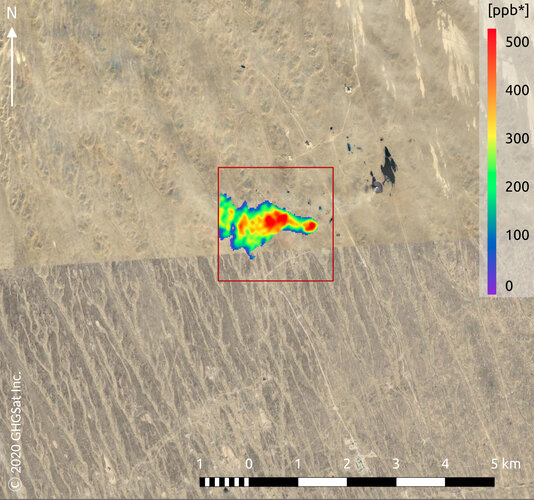
Methane may not be as abundant in the atmosphere as carbon dioxide, but with a global warming potential many times greater than carbon dioxide, monitoring and controlling industrial emissions of this potent gas is imperative to helping combat climate change. GHGSat is a New Space initiative that draws on Copernicus Sentinel-5P data for mapping methane hotspots – and its Claire satellite has now collected more than 60 000 methane measurements of industrial facilities around the world.
New Space satellite pinpoints industrial emissions of methane
29.7.2020 12:40 ESA Observing the Earth
Methane may not be as abundant in the atmosphere as carbon dioxide, but with a global warming potential many times greater than carbon dioxide, monitoring and controlling industrial emissions of this potent gas is imperative to helping combat climate change. GHGSat is a New Space initiative that draws on Copernicus Sentinel-5P data for mapping methane hotspots – and its Claire satellite has now collected more than 60 000 methane measurements of industrial facilities around the world.
Národní digitální knihovna DNNT [Knihovna geografie, byTopic]
29.7.2020 12:40 Katedra aplikované geoinformatiky a kartografie Přf UK Pro Univerzitu Karlovu je nyní přístupná Národní digitální knihovna DNNT (Děl nedostupných na trhu).Podcast s Ing. Martinem Hrdličkou
29.7.2020 8:21 Hrdlička Zakladatel společnosti Martin Hrdlička reaguje na digitalizaci stavebního řízení.Fungování společnosti v době pandemie?
29.7.2020 8:19 Hrdlička Každá firma se k situaci postavila vlastním způsobem. Podívejte se, jak to bylo u nás.Nové funkcionality ve službě UtilityReport
29.7.2020 8:19 Hrdlička Neusínáme na vavřínech. Naše služby se snažíme rozvíjet a přidávat jim hodnoty.Oznámení pro klienty
29.7.2020 7:14 ČÚZK /Urady/Katastralni-urady/Katastralni-urady/Katastralni-urad-pro-Jihocesky-kraj/O-uradu/Aktuality/Oznameni-pro-klientyOznámení pro klienty
29.7.2020 7:14 ČÚZK - předpisy a opatření Katastrální úřad pro Jihočeský kraj zveřejnil novou aktualitu: Oznámení pro klientyNa základě Nařízení mimořádného opatření č. 1/2020, vydaného Krajskou hygienickou stanicí Jihočeského kraje dne 27.7.2020, platí s účinností ode dne 29.7.2020 pro klienty na všech katastrálních pracovištích Katastrálního úřadu pro Jihočeský kraj povinnost zakrytí dýchacích cest rouškou. Dále upozorňujeme, že nadále platí zákaz pohybu klientů mimo prostory klientských center.
Esri Academy
29.7.2020 7:00 Česká asociace pro geoinformace Esri na svém webu nabízí zajímavé geoinformatické bezplatné kurzy pod jednotným názvem MOOC - Massive Open Online Courses. Kurzy jsou různě zaměřené a trvají od 4 do 6 týdnů. Podrobnosti naleznete na stránkáchManagementy v Národním parku Šumava - dílčí plochy
29.7.2020 2:00 Cenia - Katalog metadat ČR - INSPIRE Dílčí plochy jsou stanoveny Příkazem ředitele č. 168/2020 - o způsobu péče o ekosystémy NPŠ v dílčích plochách.Dílčí plocha A1 - trvalé plochy ke sledování přírodních dějů (biomonitoring) - bez aktivního managementu (režim lovu dle dílčí plochy, která DP A1 obklopuje)Dílčí plocha A2 - území nerušeného průběhu přírodních dějů bez lovu - bez aktivního managementu a bez lovuDílčí plocha A3 - území nerušeného průběhu přírodních dějů s lovem - bez aktivního managementu s možností regulace početnosti spárkaté zvěře a geograficky nepůvodních druhůDílčí plocha B - území bez nahodilých těžeb (jádrové území tetřeva hlušce mimo území DP A1, A2, A3Dílčí plocha C1 - trvalé plochy ke sledování přírodních dějů (biomonitoring) s možností speciálních opatření proti šíření kůrovce - Bez aktivního managementu smožností výjimečné asanace kůrovcem napadených stromů nebo zlomů a vývratůDílčí plocha C2 - území ekosystémů v cílovém stavu, změna ekosystému možná pouze výjimečně a krátkodobě provedenými speciálními opatřeními včetně opatření proti šíření kůrovceDílčí plocha C3 - území s možností speciálních opatření proti šíření kůrovce - bez aktivního managementu s výjimečnou asanací kůrovcem napadených stromů nebo zlomů a vývratůDílčí plocha D1 - území se střednědobým aktivním managementem, kde je dlouhodobým cílem nerušený průběh přírodních dějůDílčí plocha D2 - území s dlouhodobým aktivním managementem, kde je dlouhodobým cílem nerušený průběh přírodních dějů nebo biodiverzitaDílčí plocha E, F - nelesní plochy, stavbyDílčí plocha G - polyfunkční - ochrana fuknční technické infastruktury, speciální managementy)3D BIM processes used in design of Qatar Office Tower
28.7.2020 19:31 Bentley SystemsPress Coverage
International Construction, UK
Read the articleBentley Systems Adds Infrastructure Industry Experience to Digital Twin Consortium
28.7.2020 19:27 Bentley SystemsPress Coverage
Architosh, USA
Read the articleFinally, Digital Twins Get Their Own Consortium
28.7.2020 19:21 Bentley SystemsPress Coverage
Engineering.com, USA
Read the articleDigital Twins in Construction
28.7.2020 19:19 Bentley SystemsPress Coverage
Constructech, USA
Read the articleHydropower and the impact of COVID-19
28.7.2020 19:17 Bentley SystemsPress Coverage
Water Power Magazine, UK
Read the articleBentley Systems helps close the global productivity gap with Azure Digital Twins
28.7.2020 19:15 Bentley SystemsPress Coverage
Microsoft, USA
Read the articleBentley Systems opens up access to ProjectWise 365 to support remote civil engineering teams
28.7.2020 19:12 Bentley SystemsPress Coverage
SPAR 3D, USA
Read the article“Connected Highway” Demonstrator Shows How Easy It Can Be to Federate IoT Data in Infrastructure Digital Twins
28.7.2020 19:10 Bentley SystemsPress Coverage
Informed Infrastructure, USA
Read the articleDigital twins prove game-changer for Bergen’s light rail extension
28.7.2020 19:05 Bentley SystemsPress Coverage
PBC Today, UK
Read the articleBentley Civil Design’s Answer to the New Normal: The Digital Twin
28.7.2020 18:55 Bentley SystemsPress Coverage
AECCafe.com, USA
Read the article1Spatial become a corporate member of DAMA UK
28.7.2020 18:50 GISCafe.com Webcasts-Webinars 1Spatial become a corporate member of DAMA UKJoining a community of data professionals in the UK who champion the value of data …
S&P CoreLogic Case-Shiller Index Reports 4.5% Annual Home Price Gain In May
28.7.2020 18:50 GISCafe.com Webcasts-Webinars NEW YORK, July 28, 2020 — (PRNewswire) — S&P Dow Jones Indices today released the latest results for the S&P CoreLogic …Bulzi Selects Draganfly to be its Sole Provider of Drones and Aerial Sensors for DoD Base Security Development Projects
28.7.2020 16:38 GISCafe.com Webcasts-Webinars Los Angeles, CA, July 28, 2020 (GLOBE NEWSWIRE) -- Draganfly Inc. (CSE: DFLY) (OTCQB: DFLYF) (FSE: 3U8) (“Draganfly” or the “Company”), an …Esri and United Nations Create COVID-19 Population Vulnerability Dashboard
28.7.2020 16:38 GISCafe.com Webcasts-Webinars New Tool Will Help Public Health Organizations Use Census Data to Fight PandemicREDLANDS, Calif. — (BUSINESS WIRE) — July 28, 2020 …
Intrado Life & Safety Announces Agreement with RapidSOS to Provide Location Data for Call Handling and Mapping Solutions
28.7.2020 16:38 GISCafe.com Webcasts-Webinars Intrado’s suite of call handling and mapping solutions, including VIPER/Power 911, will now include supplemental location data provided by …HawkEye 360 Announces a Global Radio Signal Monitoring Service
28.7.2020 16:38 GISCafe.com Webcasts-Webinars The Regional Awareness Subscription service delivers daily signal geolocation data for large regionsHERNDON, Va., July 28, 2020 — (PRNewswire) …
Woolpert Selected by National Safe Skies Alliance to Develop UAS Response Guidebook for Airports
28.7.2020 16:38 GISCafe.com Webcasts-Webinars The document will provide planning considerations, response strategies and resources for airports to employ when a UAS is detected.DAYTON, Ohio, …
Duke Robotics Presents TIKAD Combat Drone Equipped with Innovative Stabilization Technology
28.7.2020 16:38 GISCafe.com Webcasts-Webinars After last month's acquisition by UAS Drone Corp (OTC: USDR), Duke Robotics has focused on engaging in a strategic expansion effort mainly in the …Workhorse Receives HVIP Eligibility from the California Air Resources Board
28.7.2020 16:38 GISCafe.com Webcasts-Webinars CINCINNATI, July 28, 2020 — (PRNewswire) — Workhorse Group Inc. (Nasdaq: WKHS) ("Workhorse" or the "Company"), an American …Explorium, augmenting data discovery for better predictions, announces $31M in funding to accelerate growth
28.7.2020 16:38 GISCafe.com Webcasts-Webinars Explorium is changing the way companies find and use data for superior machine learning models and business decisionsSAN MATEO, Calif., July 28, …
ROZŠIŘTE NÁŠ TÝM: obchodní asistentka v geoinformatice
28.7.2020 16:12 TopGis Máš ráda komunikaci se zákazníky? Máš týmového ducha? Baví Tě pracovat s „papírovou“ agendou? Baví Tě spolupracovat s kolegy a společným úsilím dosahovat cíle? Umíš najít a navrhnout jiné řešení? Pokud ano, tak hledáme právě Tebe. Co požadujeme: Co očekáváme: Co Vám nabízíme: Pokud Vás tato pozice zaujala, zašlete nám Váš CV na e-mail: kariera@topgis.cz.20200728 Odborný / vrchní referent oddělení právních vztahů k nemovitostem
28.7.2020 10:49 ČÚZK - předpisy a opatření Katastrální úřad pro Středočeský kraj - Katastrální pracoviště Mladá Boleslav Vyhlášení výběrového řízení: Odborný / vrchní referent oddělení právních vztahů k nemovitostem V části "Úřední deska", v sekci "Oznámení a jiná úřední sdělení" bylo vystaveno "Oznámení o vyhlášení výběrového řízení na obsazení služebního místa Odborný / vrchní referent oddělení právních vztahů k nemovitostem"20200728 Odborný / vrchní referent oddělení právních vztahů k nemovitostem
28.7.2020 10:49 ČÚZK /Urady/Katastralni-urady/Katastralni-urady/Katastralni-urad-pro-Stredocesky-kraj/Katastralni-pracoviste/KP-Mlada-Boleslav/O-uradu/Aktuality/20200526-Rada-odborny-rada-oddeleni-pravnich-v-(1)Odborný / vrchní referent oddělení právních vztahů k nemovitostem
28.7.2020 10:48 ČÚZK - předpisy a opatření Katastrální úřad pro Středočeský kraj - Katastrální pracoviště Mladá Boleslavvypisuje výběrové řízení na místo Odborný / vrchní referent oddělení právních vztahů k nemovitostem
Odborný / vrchní referent oddělení právních vztahů k nemovitostem
Odborný / vrchní referent oddělení právních vztahů k nemovitostem
28.7.2020 10:48 ČÚZK - volná místa Katastrální úřad pro Středočeský kraj - Katastrální pracoviště Mladá Boleslav vypisuje výběrové řízení na místo Odborný / vrchní referent oddělení právních vztahů k nemovitostemOdborný / vrchní referent oddělení právních vztahů k nemovitostem
28.7.2020 10:48 ČÚZK /Urady/Katastralni-urady/Katastralni-urady/Katastralni-urad-pro-Stredocesky-kraj/Uredni-deska/Oznameni-a-jina-uredni-sdeleni/Volna-mista/Odborny-vrchni-referent-oddeleni-pravnich-vzta-(1)20200728 Odborný / vrchní referent oddělení aktualizace katastru nemovitostí
28.7.2020 8:52 ČÚZK - předpisy a opatření Katastrální úřad pro Středočeský kraj - Katastrální pracoviště Mladá Boleslav Vyhlášení výběrového řízení: Odborný / vrchní referent oddělení aktualizace katastru nemovitostí V části "Úřední deska", v sekci "Oznámení a jiná úřední sdělení" bylo vystaveno "Oznámení o vyhlášení výběrového řízení na obsazení služebního místa Odborný / vrchní referent oddělení aktualizace katastru nemovitostí"20200728 Odborný / vrchní referent oddělení aktualizace katastru nemovitostí
28.7.2020 8:52 ČÚZK /Urady/Katastralni-urady/Katastralni-urady/Katastralni-urad-pro-Stredocesky-kraj/Katastralni-pracoviste/KP-Mlada-Boleslav/O-uradu/Aktuality/20200526-Rada-odborny-rada-oddeleni-pravnich-vztOdborný / vrchní referent oddělení aktualizace katastru nemovitostí
28.7.2020 8:51 ČÚZK - volná místa Katastrální úřad pro Středočeský kraj - Katastrální pracoviště Mladá Boleslav vypisuje výběrové řízení na místo Odborný / vrchní referent oddělení aktualizace katastru nemovitostíOdborný / vrchní referent oddělení aktualizace katastru nemovitostí
28.7.2020 8:51 ČÚZK /Urady/Katastralni-urady/Katastralni-urady/Katastralni-urad-pro-Stredocesky-kraj/Uredni-deska/Oznameni-a-jina-uredni-sdeleni/Volna-mista/Odborny-vrchni-referent-oddeleni-aktualizace-k-(1)Odborný / vrchní referent oddělení aktualizace katastru nemovitostí
28.7.2020 8:51 ČÚZK - předpisy a opatření Katastrální úřad pro Středočeský kraj - Katastrální pracoviště Mladá Boleslavvypisuje výběrové řízení na místo Odborný / vrchní referent oddělení aktualizace katastru nemovitostí
Odborný / vrchní referent oddělení aktualizace katastru nemovitostí
ČÚZK ve čtvrtek 30.07.2020 od
28.7.2020 8:07 GEUSware ČÚZK ve čtvrtek 30.07.2020 od 15:30 až do pátku 31.07.2020 do cca 01:00 zcela přeruší provoz Dálkového přístupu (DP) i Webových služeb dálkového přístupu (WSDP). Z tohoto důvodu budou v GEUSu nefunkční Podklady měření a Odesílání GP.Výběrové řízení na prodej nepotřebného majetku
28.7.2020 6:40 ČÚZK - předpisy a opatřeníKatastrální úřad pro Liberecký kraj nabízí nepotřebný majetek k odkupu. Jedná se o
Výběrové řízení na prodej nepotřebného majetku