


![]()

zprávy
zdroje zpráv:Barcelona, Spain
12.6.2020 10:00 ESA Observing the Earth Image:
The Copernicus Sentinel-2 mission takes us over Barcelona – the second largest city in Spain.
On the northeast coast of the Iberian Peninsula, Barcelona occupies a low plateau along the Mediterranean coastal plain. The city and its red roofs contrast with the forested hills and the sea that surround it.
The famous Avinguda Diagonal avenue can be seen in the right of the image. The road is one of Barcelona’s broadest avenues and cuts the city diagonally in two, hence its name. The circular Plaça de les Glòries Catalanes was meant to be the city centre in the original urban plan, but nowadays is used largely as a roundabout.
Dominating the left side of the image are the Garraf Massif mountains, their cliffs reaching the Mediterranean coast. Its highest point on the coastal side is La Morella – almost 600 m above sea level.
The Llobregat River can be seen entering the image in the top left. The river rises in the eastern Pyrenees and flows southeast before emptying into the Mediterranean Sea. Before reaching the sea, the river forms a small delta, which used to provide a large extension of fertile land but is now largely urbanised. Barcelona-El Prat airport can be seen to the left of the river. Along the coast, the port of Barcelona, one of Europe’s top ten largest container ports, is visible.
Barcelona is home to the Universitat Politècnica de Catalunya – the largest engineering university in Catalonia. In 2017, the university won ESA’s Small Satellite Challenge and the top prize at the Copernicus Masters competition with its Federated Satellite Systems (FSSCat) project. The FSSCat mission consists of two small CubeSat satellites, each about the size of a shoebox, and will use state-of-the-art dual microwave and multispectral optical sensors.
Ф-sat-1 – an enhancement of FSSCat carried on one of the two CubeSats – is set to launch soon from Europe’s spaceport in Kourou. It will be the first experiment to demonstrate how artificial intelligence can be used for Earth observation. Ф-sat-1 will have the ability to filter out less than perfect images so that only usable data are returned to Earth. This will allow for the efficient handling of data so that users will have access to timely information – ultimately benefiting society at large.
Ф-sat-1 will acquire an enormous number of images that will allow scientists to detect urban heat islands, monitor changes in vegetation and water quality, as well as carry out experiments on the role of evapotranspiration in climate change.
This image, which was captured on 16 March 2017, is also featured on the Earth from Space video programme.
Volná pozice: Web developer, konzultant
12.6.2020 10:00 ARCDATAMáte rádi mapy, moderní mapové aplikace a máte chuť se podílet na rozvoji softwaru, který je vytváří? Chcete pracovat pro leadera na českém i světovém trhu v oblasti geoinformatiky? Chcete být členem dobře fungujícího týmu? Pak vás rádi poznáme.
Koho hledáme?
Protože chceme náš tým rozšířit o další konzultanty a vývojáře webového GIS, hledáme někoho, kdo má alespoň základní znalosti a schopnosti vývoje ve webovém prostředí – primárně vývoje klientských aplikací v JavaScript (ES6, TypeScript, HTML5, CSS3) a ideálně i serverových aplikací nad platformou .NET či Java.
Na co se můžete těšit?
Na práci v menších týmech, kde táhneme za jeden provaz a učíme se jeden od druhého navzájem. Na projekty plné inovativních a technologicky progresivních řešení. Na moderní IT a software opravdového leadera na trhu GIS. Na další vzdělávání, a to nejen formou různých externích školení, ale také interních kurzů v ARCDATA nebo přímo v Esri.
Pokud vás tato nabídka zaujala, napište nám na adresu jobs@arcdata.cz.

Úvodní foto: Pexels
Earth from Space: Barcelona
12.6.2020 10:00 ESA Observing the Earth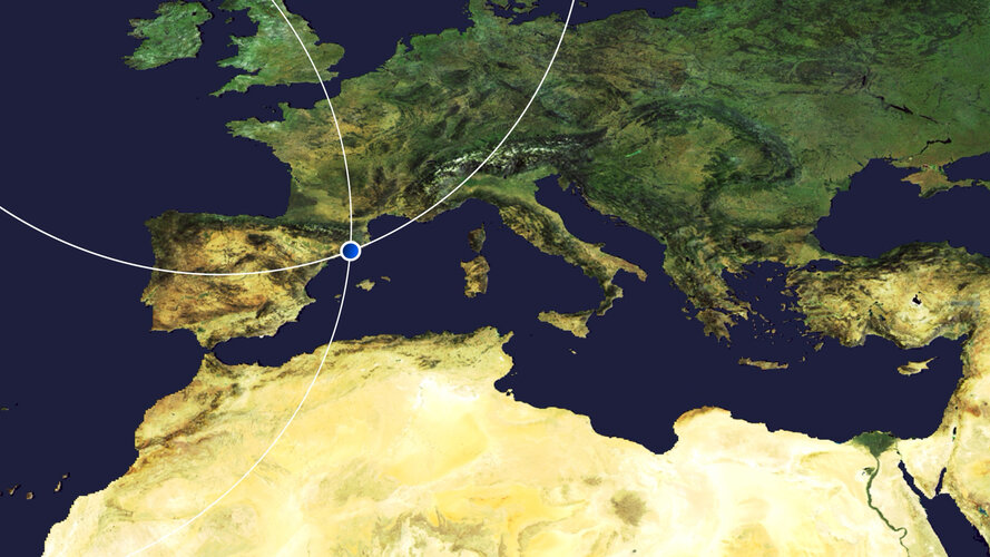 Video:
00:03:22
Video:
00:03:22
In this week's edition of the Earth from Space programme, the Copernicus Sentinel-2 mission takes us over Barcelona, the second largest city in Spain.
See also Barcelona, Spain to download the image
Volná pozice: Web developer, konzultant
12.6.2020 10:00 ARCDATAMáte rádi mapy, moderní mapové aplikace a máte chuť se podílet na rozvoji softwaru, který je vytváří? Chcete pracovat pro leadera na českém i světovém trhu v oblasti geoinformatiky? Chcete být členem dobře fungujícího týmu? Pak vás rádi poznáme.
Koho hledáme?
Protože chceme náš tým rozšířit o další konzultanty a vývojáře webového GIS, hledáme někoho, kdo má alespoň základní znalosti a schopnosti vývoje ve webovém prostředí – primárně vývoje klientských aplikací v JavaScript (ES6, TypeScript, HTML5, CSS3) a ideálně i serverových aplikací nad platformou .NET či Java.
Na co se můžete těšit?
Na práci v menších týmech, kde táhneme za jeden provaz a učíme se jeden od druhého navzájem. Na projekty plné inovativních a technologicky progresivních řešení. Na moderní IT a software opravdového leadera na trhu GIS. Na další vzdělávání, a to nejen formou různých externích školení, ale také interních kurzů v ARCDATA nebo přímo v Esri.
Pokud vás tato nabídka zaujala, napište nám na adresu jobs@arcdata.cz.
Earth from Space: Barcelona
12.6.2020 10:00 ESA Observing the Earth Video:
00:03:22
Video:
00:03:22
In this week's edition of the Earth from Space programme, the Copernicus Sentinel-2 mission takes us over Barcelona, the second largest city in Spain.
See also Barcelona, Spain to download the image
odborný referent - návrh zápisu v katastru v odd. právních vztahů KP Jindřichův Hradec
12.6.2020 9:52 ČÚZK /Urady/Katastralni-urady/Katastralni-urady/Katastralni-urad-pro-Jihocesky-kraj/Uredni-deska/Oznameni-a-jina-uredni-sdeleni/Volna-mista/DMS/odborny-referent-navrh-zapisu-v-katastru-v-oddodborný referent - návrh zápisu v katastru v odd. právních vztahů KP Jindřichův Hradec
12.6.2020 9:52 ČÚZK - volná místa Katastrální úřad pro Jihočeský kraj Katastrální pracoviště Jindřichův Hradec vypisuje výběrové řízení na místo odborný referent - návrh zápisu v katastru v odd. právních vztahů KP Jindřichův Hradecodborný referent - návrh zápisu v katastru v odd. právních vztahů KP Jindřichův Hradec
12.6.2020 9:52 ČÚZK - předpisy a opatření Katastrální úřad pro Jihočeský kraj Katastrální pracoviště Jindřichův Hradecvypisuje výběrové řízení na místo
odborný referent - návrh zápisu v katastru v odd. právních vztahů KP Jindřichův Hradec
Global ARAIM for Dual-Constellation webinar set for 24 June
12.6.2020 9:39 European GNSS Agency, GLU-2100 MMR, single frequency GPS L1 receiver, prototyped upgraded to support a GPS and Galileo DFMC GNSS and used as a baseline for the development of the ARAIM algorithm")
A webinar is being organised by the Global ARAIM for Dual-Constellation (GLAD) project, co-funded by the European GNSS Agency (GSA), which is developing the Advanced Receiver Autonomous Integrity Monitoring (ARAIM) prototype receiver under the Fundamental Elements programme. It will take place on 24 June and will cover the ARAIM concept and GLAD activities during the prototyping and demonstration of the results. You can register here.
The Advanced RAIM (ARAIM) concept extends the traditional legacy GPS single frequency Receiver Autonomous Integrity Monitoring (RAIM) by using multiple GNSS constellations that may include signals from the same satellite transmitting more than one frequency. The Galileo constellation, in addition to GPS, provides a Dual Frequency Multi-Constellation (DFMC) system that allows for robustness and redundancy. In the aviation sector, when DFMC is supported by a Satellite Based Augmentation System (SBAS) and ARAIM, satellite availability is leveraged with accuracy in position, and the associated integrity and continuity elevated in terms of radio navigation performance.
The ARAIM concept started to take shape in the Working Group C, the ARAIM Technical Subgroup, that was established in 2010, based on the US-EU bilateral agreement on GPS-Galileo co-operation agreement signed in 2004 with the goal to develop GPS-Galileo integrated applications for Safety of Life operations.
Concept wise, each GNSS Constellation Service Provider (CSP) will transmit an Integrity Support Message (ISM) to broadcast integrity information associated with its own system. The airborne receiver’s ARAIM algorithm processes this information to gain sufficient confidence in the information provided by the specific GNSS constellation in order to meet required safety criteria in terms of lateral and vertical guidance, thereby addressing the requirement for all phases of flight up to Category I (CAT I) precision approach capability/LPV 200 approach globally in the future.
GLobal ARAIM for Dual-Constellation (GLAD) is an innovative project focusing on the development of ARAIM capability within the Collins’ Global Navigation Satellite Systems (GNSS) Multi-Mode Receiver (MMR). This project is funded by the European GNSS Agency (GSA) under the “Development of an Advanced RAIM Multi-Constellation Receiver” Call for proposals. The key tenet for Collins Aerospace, a key aviation market player, was to work closely with the GSA to support the definition and development of ARAIM features to meet global airspace modernisation requirements. To that effect, Collins put together a GLAD project team which comprises Airbus, GMV, NATS and Pildo Labs to lead an ARAIM development prototyping activity. The project commenced in May 2018 and ends in June 2020.
The key objectives of the GLAD project is the maturation of the ARAIM concept by prototyping the algorithm within critical components of the Collins’ GLU-2100 Multi-Mode Receiver (MMR), followed by testing and assessing the performance of the algorithm. In addition, the project focused on concepts of operations (CONOPS) using ARAIM and collaborated with Air Navigation Service Providers (ANSPs) to engage and understand the requirements for airport operations. The team also contributed to standardisation activities within GNSS working groups.
The GLAD team has successfully conducted ground experiments demonstrating real-time horizontal and vertical ARAIM performance, with a horizontal precision of 0.3 NM and vertical precision supporting LPV-200. The future benefits will include significant contributions to improvements in position integrity, and to underpinning the economic (fuel and time), environmental (CO2) and safety aspects required by the aviation industry.
To reach the objectives set out within the project framework, the GSA and GLAD Team take the opportunity to invite stakeholders to a Webinar on 24th June 2020 to explain the ARAIM concept, outcomes of the project and show the ARAIM prototype developed. You can register here.
Media note: This feature can be republished without charge provided the European GNSS Agency (GSA) is acknowledged as the source at the top or the bottom of the story. You must request permission before you use any of the photographs on the site. If you republish, we would be grateful if you could link back to the GSA website (http://www.gsa.europa.eu).
The Global ARAIM for Dual-Constellation project and its contribution to the development of ARAIM concept for Civil Aviation
12.6.2020 9:39 European GNSS AgencyA webinar is organised by Global ARAIM for Dual-Constellation (GLAD) project, co-funded by the European GNSS Agency (GSA), that is developing the Advanced Receiver Autonomous Integrity Monitoring (RAIM) prototype receiver under the Fundamental Elements. It will take place on 24th June and will cover ARAIM concept, GLAD activities during the prototyping and demonstration of the results. You can register here.
The Advanced RAIM (ARAIM) concept extends the traditional legacy GPS single frequency Receiver Autonomous Integrity Monitoring (RAIM) by using multiple GNSS constellations that may include signals from the same satellite transmitting more than one frequency. The Galileo constellation, in addition to GPS provides a Dual Frequency Multi-Constellation (DFMC) system that allows for robustness and redundancy. In the aviation sector, when DFMC is supported by Satellite Based Augmentation System (SBAS) and ARAIM, satellite availability is leveraged with accuracy in position, and the associated integrity and continuity elevated in terms of radio navigation performance.
The ARAIM concept started to shape in the Working Group C, the ARAIM Technical Subgroup, that was established in 2010, based on the US-EU bilateral agreement on GPS-Galileo co-operation agreement signed in 2004 with the goal to develop GPS-Galileo integrated applications for Safety of Life operations.
Concept wise, each GNSS Constellation Service Provider (CSP) will transmit an Integrity Support Message (ISM) to broadcast integrity information associated with its own system. The airborne receiver’s ARAIM algorithm processes this information to gain sufficient confidence in the information provided by the specific GNSS constellation in order to meet safety-required criteria in terms of lateral and vertical guidance, and as such addressing the requirement for all phases of flight up to Category I (CAT I) precision approach capability/LPV 200 approach globally in the future.
GLobal ARAIM for Dual-Constellation (GLAD) is an innovative project focusing on development an ARAIM capability within the Collins’ Global Navigation Satellite Systems (GNSS) Multi-Mode Receiver (MMR). This project is funded by the European GNSS Agency (GSA) under the “Development of an Advanced RAIM Multi-Constellation Receiver” Call for proposal. The key tenet for Collins Aerospace, a key aviation market player, was to work closely with the GSA to support the definition and development of ARAIM features to meet the global airspace modernisation requirements. To that effect, Collins put together a GLAD project team which comprises of Airbus, GMV, NATS and Pildo Labs to lead an ARAIM development prototyping activity. The project commenced in May 2018 and completes in June 2020.
The key objectives of the GLAD project is the maturation of the ARAIM concept by prototyping the algorithm within critical components of the Collins’ GLU-2100 Multi-Mode Receiver (MMR), followed by testing and assessing the performance of the algorithm. In addition, the project focused on concepts of operations (CONOPS) using ARAIM and collaborated with Air Navigation Service Providers (ANSPs) to engage and understand the requirements for airport operations. The team also contributed to standardisation activities within GNSS working groups.
The GLAD team has successfully conducted ground experiments demonstrating real-time horizontal and vertical ARAIM performance, with a horizontal precision of 0.3 NM and vertical precision supporting LPV-200. The future benefits to this will be significant contributions to improvements in position integrity, and underpins the economic (fuel and time), environmental (CO2) and safety aspects required by the aviation industry.
To conclude the objectives set out within the project framework, the GSA and GLAD Team take the opportunity to invite the stakeholders to a Webinar on 24th June 2020 to explain the ARAIM concept, outcomes of the project and show the ARAIM prototype developed. You can register here.
Media note: This feature can be republished without charge provided the European GNSS Agency (GSA) is acknowledged as the source at the top or the bottom of the story. You must request permission before you use any of the photographs on the site. If you republish, we would be grateful if you could link back to the GSA website (http://www.gsa.europa.eu).
Let’s learn about the Global ARAIM for Dual-Constellation (GLAD) project and its contribution to the development of ARAIM concept for Civil Aviation
12.6.2020 9:39 European GNSS AgencyA webinar is organised by Global ARAIM for Dual-Constellation (GLAD) project, co-funded by the European GNSS Agency (GSA), that is developing the Advanced Receiver Autonomous Integrity Monitoring (RAIM) prototype receiver under the Fundamental Elements. It will take place on 24th June and will cover ARAIM concept, GLAD activities during the prototyping and demonstration of the results. You can register here.
The Advanced RAIM (ARAIM) concept extends the traditional legacy GPS single frequency Receiver Autonomous Integrity Monitoring (RAIM) by using multiple GNSS constellations that may include signals from the same satellite transmitting more than one frequency. The Galileo constellation, in addition to GPS provides a Dual Frequency Multi-Constellation (DFMC) system that allows for robustness and redundancy. In the aviation sector, when DFMC is supported by Satellite Based Augmentation System (SBAS) and ARAIM, satellite availability is leveraged with accuracy in position, and the associated integrity and continuity elevated in terms of radio navigation performance.
The ARAIM concept started to shape in the Working Group C, the ARAIM Technical Subgroup, that was established in 2010, based on the US-EU bilateral agreement on GPS-Galileo co-operation agreement signed in 2004 with the goal to develop GPS-Galileo integrated applications for Safety of Life operations.
Concept wise, each GNSS Constellation Service Provider (CSP) will transmit an Integrity Support Message (ISM) to broadcast integrity information associated with its own system. The airborne receiver’s ARAIM algorithm processes this information to gain sufficient confidence in the information provided by the specific GNSS constellation in order to meet safety-required criteria in terms of lateral and vertical guidance, and as such addressing the requirement for all phases of flight up to Category I (CAT I) precision approach capability/LPV 200 approach globally in the future.
GLobal ARAIM for Dual-Constellation (GLAD) is an innovative project focusing on development an ARAIM capability within the Collins’ Global Navigation Satellite Systems (GNSS) Multi-Mode Receiver (MMR). This project is funded by the European GNSS Agency (GSA) under the “Development of an Advanced RAIM Multi-Constellation Receiver” Call for proposal. The key tenet for Collins Aerospace, a key aviation market player, was to work closely with the GSA to support the definition and development of ARAIM features to meet the global airspace modernisation requirements. To that effect, Collins put together a GLAD project team which comprises of Airbus, GMV, NATS and Pildo Labs to lead an ARAIM development prototyping activity. The project commenced in May 2018 and completes in June 2020.
The key objectives of the GLAD project is the maturation of the ARAIM concept by prototyping the algorithm within critical components of the Collins’ GLU-2100 Multi-Mode Receiver (MMR), followed by testing and assessing the performance of the algorithm. In addition, the project focused on concepts of operations (CONOPS) using ARAIM and collaborated with Air Navigation Service Providers (ANSPs) to engage and understand the requirements for airport operations. The team also contributed to standardisation activities within GNSS working groups.
The GLAD team has successfully conducted ground experiments demonstrating real-time horizontal and vertical ARAIM performance, with a horizontal precision of 0.3 NM and vertical precision supporting LPV-200. The future benefits to this will be significant contributions to improvements in position integrity, and underpins the economic (fuel and time), environmental (CO2) and safety aspects required by the aviation industry.
To conclude the objectives set out within the project framework, the GSA and GLAD Team take the opportunity to invite the stakeholders to a Webinar on 24th June 2020 to explain the ARAIM concept, outcomes of the project and show the ARAIM prototype developed. You can register here.
Media note: This feature can be republished without charge provided the European GNSS Agency (GSA) is acknowledged as the source at the top or the bottom of the story. You must request permission before you use any of the photographs on the site. If you republish, we would be grateful if you could link back to the GSA website (http://www.gsa.europa.eu).
Global ARAIM for Dual-Constellation webinar took place on 24 June 2020
12.6.2020 9:39 European GNSS AgencyA webinar was organised by the Global ARAIM for Dual-Constellation (GLAD) project, co-funded by the European GNSS Agency (GSA), which is developing the Advanced Receiver Autonomous Integrity Monitoring (RAIM) prototype receiver under the Fundamental Elements programme. With more than 80 participants, the webinar covered the ARAIM concept and GLAD activities during the prototyping and demonstration of the results.
The Advanced RAIM (ARAIM) concept extends the traditional legacy GPS single frequency Receiver Autonomous Integrity Monitoring (RAIM) by using multiple GNSS constellations that may include signals from the same satellite transmitting more than one frequency. The Galileo constellation, in addition to GPS, provides a Dual Frequency Multi-Constellation (DFMC) system that allows for robustness and redundancy. In the aviation sector, when DFMC is supported by a Satellite Based Augmentation System (SBAS) and ARAIM, satellite availability is leveraged with accuracy in position, and the associated integrity and continuity elevated in terms of radio navigation performance.
The ARAIM concept started to take shape in the Working Group C, the ARAIM Technical Subgroup, that was established in 2010, based on the US-EU bilateral agreement on GPS-Galileo co-operation agreement signed in 2004 with the goal to develop GPS-Galileo integrated applications for Safety of Life operations.
Concept wise, each GNSS Constellation Service Provider (CSP) will transmit an Integrity Support Message (ISM) to broadcast integrity information associated with its own system. The airborne receiver’s ARAIM algorithm processes this information to gain sufficient confidence in the information provided by the specific GNSS constellation in order to meet required safety criteria in terms of lateral and vertical guidance, thereby addressing the requirement for all phases of flight up to Category I (CAT I) precision approach capability/LPV 200 approach globally in the future.
GLobal ARAIM for Dual-Constellation (GLAD) is an innovative project focusing on the development of ARAIM capability within the Collins’ Global Navigation Satellite Systems (GNSS) Multi-Mode Receiver (MMR). This project is funded by the European GNSS Agency (GSA) under the “Development of an Advanced RAIM Multi-Constellation Receiver” Call for proposals. The key tenet for Collins Aerospace, a key aviation market player, was to work closely with the GSA to support the definition and development of ARAIM features to meet global airspace modernisation requirements. To that effect, Collins put together a GLAD project team which comprises Airbus, GMV, NATS and Pildo Labs to lead an ARAIM development prototyping activity. The project commenced in May 2018 and ends in June 2020.
The key objectives of the GLAD project is the maturation of the ARAIM concept by prototyping the algorithm within critical components of the Collins’ GLU-2100 Multi-Mode Receiver (MMR), followed by testing and assessing the performance of the algorithm. In addition, the project focused on concepts of operations (CONOPS) using ARAIM and collaborated with Air Navigation Service Providers (ANSPs) to engage and understand the requirements for airport operations. The team also contributed to standardisation activities within GNSS working groups.
The GLAD team has successfully conducted ground experiments demonstrating real-time horizontal and vertical ARAIM performance, with a horizontal precision of 0.3 NM and vertical precision supporting LPV-200. The future benefits will include significant contributions to improvements in position integrity, and to underpinning the economic (fuel and time), environmental (CO2) and safety aspects required by the aviation industry.
To reach the objectives set out within the project framework, the GSA and GLAD Team took the opportunity to invite stakeholders to a webinar on 24th June 2020 to explain the ARAIM concept, outcomes of the project and show the ARAIM prototype developed. You can now check the presentation shared during the webinar on this page.
Media note: This feature can be republished without charge provided the European GNSS Agency (GSA) is acknowledged as the source at the top or the bottom of the story. You must request permission before you use any of the photographs on the site. If you republish, we would be grateful if you could link back to the GSA website (http://www.gsa.europa.eu).
The Global ARAIM for Dual-Constellation project and its contribution to the development of ARAIM concept for Civil Aviation
12.6.2020 9:39 European GNSS AgencyA webinar is being organised by the Global ARAIM for Dual-Constellation (GLAD) project, co-funded by the European GNSS Agency (GSA), which is developing the Advanced Receiver Autonomous Integrity Monitoring (ARAIM) prototype receiver under the Fundamental Elements programme. It will take place on 24 June and will cover the ARAIM concept and GLAD activities during the prototyping and demonstration of the results. You can register here.
The Advanced RAIM (ARAIM) concept extends the traditional legacy GPS single frequency Receiver Autonomous Integrity Monitoring (RAIM) by using multiple GNSS constellations that may include signals from the same satellite transmitting more than one frequency. The Galileo constellation, in addition to GPS, provides a Dual Frequency Multi-Constellation (DFMC) system that allows for robustness and redundancy. In the aviation sector, when DFMC is supported by a Satellite Based Augmentation System (SBAS) and ARAIM, satellite availability is leveraged with accuracy in position, and the associated integrity and continuity elevated in terms of radio navigation performance.
The ARAIM concept started to take shape in the Working Group C, the ARAIM Technical Subgroup, that was established in 2010, based on the US-EU bilateral agreement on GPS-Galileo co-operation agreement signed in 2004 with the goal to develop GPS-Galileo integrated applications for Safety of Life operations.
Concept wise, each GNSS Constellation Service Provider (CSP) will transmit an Integrity Support Message (ISM) to broadcast integrity information associated with its own system. The airborne receiver’s ARAIM algorithm processes this information to gain sufficient confidence in the information provided by the specific GNSS constellation in order to meet required safety criteria in terms of lateral and vertical guidance, thereby addressing the requirement for all phases of flight up to Category I (CAT I) precision approach capability/LPV 200 approach globally in the future.
GLobal ARAIM for Dual-Constellation (GLAD) is an innovative project focusing on the development of ARAIM capability within the Collins’ Global Navigation Satellite Systems (GNSS) Multi-Mode Receiver (MMR). This project is funded by the European GNSS Agency (GSA) under the “Development of an Advanced RAIM Multi-Constellation Receiver” Call for proposals. The key tenet for Collins Aerospace, a key aviation market player, was to work closely with the GSA to support the definition and development of ARAIM features to meet global airspace modernisation requirements. To that effect, Collins put together a GLAD project team which comprises Airbus, GMV, NATS and Pildo Labs to lead an ARAIM development prototyping activity. The project commenced in May 2018 and ends in June 2020.
The key objectives of the GLAD project is the maturation of the ARAIM concept by prototyping the algorithm within critical components of the Collins’ GLU-2100 Multi-Mode Receiver (MMR), followed by testing and assessing the performance of the algorithm. In addition, the project focused on concepts of operations (CONOPS) using ARAIM and collaborated with Air Navigation Service Providers (ANSPs) to engage and understand the requirements for airport operations. The team also contributed to standardisation activities within GNSS working groups.
The GLAD team has successfully conducted ground experiments demonstrating real-time horizontal and vertical ARAIM performance, with a horizontal precision of 0.3 NM and vertical precision supporting LPV-200. The future benefits will include significant contributions to improvements in position integrity, and to underpinning the economic (fuel and time), environmental (CO2) and safety aspects required by the aviation industry.
To reach the objectives set out within the project framework, the GSA and GLAD Team take the opportunity to invite stakeholders to a Webinar on 24th June 2020 to explain the ARAIM concept, outcomes of the project and show the ARAIM prototype developed. You can register here.
Media note: This feature can be republished without charge provided the European GNSS Agency (GSA) is acknowledged as the source at the top or the bottom of the story. You must request permission before you use any of the photographs on the site. If you republish, we would be grateful if you could link back to the GSA website (http://www.gsa.europa.eu).
The Global ARAIM for Dual-Constellation project and its contribution to the development of ARAIM concept for Civil Aviation
12.6.2020 9:39 European GNSS AgencyA webinar is organised by Global ARAIM for Dual-Constellation (GLAD) project, co-funded by the European GNSS Agency (GSA), that is developing the Advanced Receiver Autonomous Integrity Monitoring (ARAIM) prototype receiver under the Fundamental Elements. It will take place on 24th June and will cover ARAIM concept, GLAD activities during the prototyping and demonstration of the results. You can register here.
The Advanced RAIM (ARAIM) concept extends the traditional legacy GPS single frequency Receiver Autonomous Integrity Monitoring (RAIM) by using multiple GNSS constellations that may include signals from the same satellite transmitting more than one frequency. The Galileo constellation, in addition to GPS provides a Dual Frequency Multi-Constellation (DFMC) system that allows for robustness and redundancy. In the aviation sector, when DFMC is supported by Satellite Based Augmentation System (SBAS) and ARAIM, satellite availability is leveraged with accuracy in position, and the associated integrity and continuity elevated in terms of radio navigation performance.
The ARAIM concept started to shape in the Working Group C, the ARAIM Technical Subgroup, that was established in 2010, based on the US-EU bilateral agreement on GPS-Galileo co-operation agreement signed in 2004 with the goal to develop GPS-Galileo integrated applications for Safety of Life operations.
Concept wise, each GNSS Constellation Service Provider (CSP) will transmit an Integrity Support Message (ISM) to broadcast integrity information associated with its own system. The airborne receiver’s ARAIM algorithm processes this information to gain sufficient confidence in the information provided by the specific GNSS constellation in order to meet safety-required criteria in terms of lateral and vertical guidance, and as such addressing the requirement for all phases of flight up to Category I (CAT I) precision approach capability/LPV 200 approach globally in the future.
GLobal ARAIM for Dual-Constellation (GLAD) is an innovative project focusing on development an ARAIM capability within the Collins’ Global Navigation Satellite Systems (GNSS) Multi-Mode Receiver (MMR). This project is funded by the European GNSS Agency (GSA) under the “Development of an Advanced RAIM Multi-Constellation Receiver” Call for proposal. The key tenet for Collins Aerospace, a key aviation market player, was to work closely with the GSA to support the definition and development of ARAIM features to meet the global airspace modernisation requirements. To that effect, Collins put together a GLAD project team which comprises of Airbus, GMV, NATS and Pildo Labs to lead an ARAIM development prototyping activity. The project commenced in May 2018 and completes in June 2020.
The key objectives of the GLAD project is the maturation of the ARAIM concept by prototyping the algorithm within critical components of the Collins’ GLU-2100 Multi-Mode Receiver (MMR), followed by testing and assessing the performance of the algorithm. In addition, the project focused on concepts of operations (CONOPS) using ARAIM and collaborated with Air Navigation Service Providers (ANSPs) to engage and understand the requirements for airport operations. The team also contributed to standardisation activities within GNSS working groups.
The GLAD team has successfully conducted ground experiments demonstrating real-time horizontal and vertical ARAIM performance, with a horizontal precision of 0.3 NM and vertical precision supporting LPV-200. The future benefits to this will be significant contributions to improvements in position integrity, and underpins the economic (fuel and time), environmental (CO2) and safety aspects required by the aviation industry.
To conclude the objectives set out within the project framework, the GSA and GLAD Team take the opportunity to invite the stakeholders to a Webinar on 24th June 2020 to explain the ARAIM concept, outcomes of the project and show the ARAIM prototype developed. You can register here.
Media note: This feature can be republished without charge provided the European GNSS Agency (GSA) is acknowledged as the source at the top or the bottom of the story. You must request permission before you use any of the photographs on the site. If you republish, we would be grateful if you could link back to the GSA website (http://www.gsa.europa.eu).
Global ARAIM for Dual-Constellation webinar took place on 24 June 2020
12.6.2020 9:39 European GNSS AgencyA webinar was organised by the Global ARAIM for Dual-Constellation (GLAD) project, co-funded by the European GNSS Agency (GSA), which is developing the Advanced Receiver Autonomous Integrity Monitoring (RAIM) prototype receiver under the Fundamental Elements programme. It took place on 24 June 2020 and covered the ARAIM concept and GLAD activities during the prototyping and demonstration of the results.
The Advanced RAIM (ARAIM) concept extends the traditional legacy GPS single frequency Receiver Autonomous Integrity Monitoring (RAIM) by using multiple GNSS constellations that may include signals from the same satellite transmitting more than one frequency. The Galileo constellation, in addition to GPS, provides a Dual Frequency Multi-Constellation (DFMC) system that allows for robustness and redundancy. In the aviation sector, when DFMC is supported by a Satellite Based Augmentation System (SBAS) and ARAIM, satellite availability is leveraged with accuracy in position, and the associated integrity and continuity elevated in terms of radio navigation performance.
The ARAIM concept started to take shape in the Working Group C, the ARAIM Technical Subgroup, that was established in 2010, based on the US-EU bilateral agreement on GPS-Galileo co-operation agreement signed in 2004 with the goal to develop GPS-Galileo integrated applications for Safety of Life operations.
Concept wise, each GNSS Constellation Service Provider (CSP) will transmit an Integrity Support Message (ISM) to broadcast integrity information associated with its own system. The airborne receiver’s ARAIM algorithm processes this information to gain sufficient confidence in the information provided by the specific GNSS constellation in order to meet required safety criteria in terms of lateral and vertical guidance, thereby addressing the requirement for all phases of flight up to Category I (CAT I) precision approach capability/LPV 200 approach globally in the future.
GLobal ARAIM for Dual-Constellation (GLAD) is an innovative project focusing on the development of ARAIM capability within the Collins’ Global Navigation Satellite Systems (GNSS) Multi-Mode Receiver (MMR). This project is funded by the European GNSS Agency (GSA) under the “Development of an Advanced RAIM Multi-Constellation Receiver” Call for proposals. The key tenet for Collins Aerospace, a key aviation market player, was to work closely with the GSA to support the definition and development of ARAIM features to meet global airspace modernisation requirements. To that effect, Collins put together a GLAD project team which comprises Airbus, GMV, NATS and Pildo Labs to lead an ARAIM development prototyping activity. The project commenced in May 2018 and ends in June 2020.
The key objectives of the GLAD project is the maturation of the ARAIM concept by prototyping the algorithm within critical components of the Collins’ GLU-2100 Multi-Mode Receiver (MMR), followed by testing and assessing the performance of the algorithm. In addition, the project focused on concepts of operations (CONOPS) using ARAIM and collaborated with Air Navigation Service Providers (ANSPs) to engage and understand the requirements for airport operations. The team also contributed to standardisation activities within GNSS working groups.
The GLAD team has successfully conducted ground experiments demonstrating real-time horizontal and vertical ARAIM performance, with a horizontal precision of 0.3 NM and vertical precision supporting LPV-200. The future benefits will include significant contributions to improvements in position integrity, and to underpinning the economic (fuel and time), environmental (CO2) and safety aspects required by the aviation industry.
To reach the objectives set out within the project framework, the GSA and GLAD Team took the opportunity to invite stakeholders to a webinar on 24th June 2020 to explain the ARAIM concept, outcomes of the project and show the ARAIM prototype developed. You can now check the presentation shared during the webinar on this page.
Media note: This feature can be republished without charge provided the European GNSS Agency (GSA) is acknowledged as the source at the top or the bottom of the story. You must request permission before you use any of the photographs on the site. If you republish, we would be grateful if you could link back to the GSA website (http://www.gsa.europa.eu).
New mapping & data collection software hits the market
12.6.2020 9:00 GISCafe.com Webcasts-Webinars U.S. hardware manufacturer creates Uinta Mapping and Data Collection Software to pair with popular rugged devices for a total solutionHassle-free …
Interview with Derrick Reish, Senior Product Manager, Laser Technology
12.6.2020 9:00 GISCafe.com Webcasts-Webinars20200612 Vedoucí oddělení dokumentace katastru nemovitostí
12.6.2020 8:46 ČÚZK /Urady/Katastralni-urady/Katastralni-urady/Katastralni-urad-pro-Stredocesky-kraj/Katastralni-pracoviste/KP-Benesov/O-uradu/Aktuality/20200612-Vedouci-oddeleni-dokumentace-katastru-nem20200612 Vedoucí oddělení dokumentace katastru nemovitostí
12.6.2020 8:46 ČÚZK - předpisy a opatření Katastrální úřad pro Středočeský kraj - Katastrální pracoviště Benešov Vyhlášení výběrového řízení: Vedoucí oddělení dokumentace katastru nemovitostí V části "Úřední deska", v sekci "Oznámení a jiná úřední sdělení" bylo vystaveno "Oznámení o vyhlášení výběrového řízení na obsazení služebního místa Vedoucí oddělení dokumentace katastru nemovitostí"20200612 Vedoucí oddělení dokumentace katastru nemovitostí
12.6.2020 8:45 ČÚZK - předpisy a opatření Katastrální úřad pro Středočeský kraj - Katastrální pracoviště Benešov Vyhlášení výběrového řízení: Vedoucí oddělení dokumentace katastru nemovitostí V části "Úřední deska", v sekci "Oznámení a jiná úřední sdělení" bylo vystaveno "Oznámení o vyhlášení výběrového řízení na obsazení služebního místa Vedoucí oddělení dokumentace katastru nemovitostí"20200612 Vedoucí oddělení dokumentace katastru nemovitostí
12.6.2020 8:45 ČÚZK /Urady/Katastralni-urady/Katastralni-urady/Katastralni-urad-pro-Stredocesky-kraj/O-uradu/Aktuality/20200612-Vedouci-oddeleni-dokumentace-katastru-nemVedoucí oddělení dokumentace katastru nemovitostí
12.6.2020 8:43 ČÚZK /Urady/Katastralni-urady/Katastralni-urady/Katastralni-urad-pro-Stredocesky-kraj/Uredni-deska/Oznameni-a-jina-uredni-sdeleni/Volna-mista/Vedouci-oddeleni-dokumentace-katastru-nemovitostiVedoucí oddělení dokumentace katastru nemovitostí
12.6.2020 8:43 ČÚZK - předpisy a opatření Katastrální úřad pro Středočeský kraj - Katastrální pracoviště Benešovvypisuje výběrové řízení na místo vedoucí oddělení dokumentace katastru nemovitostí
Vedoucí oddělení dokumentace katastru nemovitostí
Vedoucí oddělení dokumentace katastru nemovitostí
12.6.2020 8:43 ČÚZK - volná místa Katastrální úřad pro Středočeský kraj - Katastrální pracoviště Benešov vypisuje výběrové řízení na místo Vedoucí oddělení dokumentace katastru nemovitostí20200612 Vrchní referent / rada oddělení právních vztahů k nemovitostem
12.6.2020 8:34 ČÚZK - předpisy a opatření Katastrální úřad pro Středočeský kraj - Katastrální pracoviště Rakovník Vyhlášení výběrového řízení: Vrchní referent / rada oddělení právních vztahů k nemovitostem V části "Úřední deska", v sekci "Oznámení a jiná úřední sdělení" bylo vystaveno "Oznámení o vyhlášení výběrového řízení na obsazení služebního místa Vrchní referent / rada oddělení právních vztahů k nemovitostem"20200612 Vrchní referent / rada oddělení právních vztahů k nemovitostem
12.6.2020 8:34 ČÚZK /Urady/Katastralni-urady/Katastralni-urady/Katastralni-urad-pro-Stredocesky-kraj/Katastralni-pracoviste/KP-Rakovnik/O-uradu/Aktuality/20200612-Vrchni-referent-rada-oddeleni-pravnich20200612 Vrchní referent / rada oddělení právních vztahů k nemovitostem
12.6.2020 8:32 ČÚZK /Urady/Katastralni-urady/Katastralni-urady/Katastralni-urad-pro-Stredocesky-kraj/O-uradu/Aktuality/20200612-Vrchni-referent-rada-oddeleni-pravnich20200612 Vrchní referent / rada oddělení právních vztahů k nemovitostem
12.6.2020 8:32 ČÚZK - předpisy a opatření Katastrální úřad pro Středočeský kraj - Katastrální pracoviště Rakovník Vyhlášení výběrového řízení: Vrchní referent / rada oddělení právních vztahů k nemovitostem V části "Úřední deska", v sekci "Oznámení a jiná úřední sdělení" bylo vystaveno "Oznámení o vyhlášení výběrového řízení na obsazení služebního místa Vrchní referent / rada oddělení právních vztahů k nemovitostem"Vrchní referent / rada oddělení právních vztahů k nemovitostem
12.6.2020 8:29 ČÚZK - předpisy a opatření Katastrální úřad pro Středočeský kraj - Katastrální pracoviště Rakovníkvypisuje výběrové řízení na místo Vrchní referent / rada oddělení právních vztahů k nemovitostem
Vrchní referent / rada oddělení právních vztahů k nemovitostem
Vrchní referent / rada oddělení právních vztahů k nemovitostem
12.6.2020 8:29 ČÚZK /Urady/Katastralni-urady/Katastralni-urady/Katastralni-urad-pro-Stredocesky-kraj/Uredni-deska/Oznameni-a-jina-uredni-sdeleni/Volna-mista/Vrchni-referent-rada-oddeleni-pravnich-vztahu-kVrchní referent / rada oddělení právních vztahů k nemovitostem
12.6.2020 8:29 ČÚZK - volná místa Katastrální úřad pro Středočeský kraj - Katastrální pracoviště Rakovník vypisuje výběrové řízení na místo Vrchní referent / rada oddělení právních vztahů k nemovitostemNabídka nepotřebného majetku
12.6.2020 8:29 ČÚZK - předpisy a opatřeníKatastrální úřad pro Olomoucký kraj nabízí nepotřebný majetek k odkupu. Jedná se o
Nabídka nepotřebného majetku
Katastrální mapa ve formátech DGN a DXF poskytovaná v e-shopu
12.6.2020 2:00 Cenia - Katalog metadat ČR - INSPIRE Katastrální mapa je závazným státním mapovým dílem velkého měřítka, obsahuje body polohového bodového pole, polohopis a popis. Katastrální mapa ve vektorové podobě je poskytována zdarma ve formátu DGN a DXF a obsahuje prvky Digitální katastrální mapy (DKM) a Katastrální mapy digitalizované (KMD), tedy bodová pole, budovy, další prvky mapy, hranice parcel, katastrální hranice, parcely katastru nemovitostí, prvky orientační mapy a hranice věcného břemene. Z důvodu použití formátu DGN produkt neobsahuje značky na liniích a oblouky jsou nahrazeny lomenými čárami. Katastrální mapa ve vektorové podobě k 08. 06. 2020 pokrývá 96,80% území České republiky, t.j. 76 341,13km2. Více katastrální vyhláška č.357/2013 Sb. v platném znění.INSPIRE téma Adresy (AD)
12.6.2020 2:00 Cenia - Katalog metadat ČR - INSPIRE Data odpovídají směrnici INSPIRE pro téma adresy (AD). Vychází především z projektu RÚIAN (Registr územní identifikace, adres a nemovitostí), který je součástí základních registrů České Republiky a obsahuje informace o územní identifikaci, adresách a nemovitostech. Data publikovaná v rámci INSPIRE obsahují pouze adresní místa a jejich komponenty, kterými jsou stát, obec, část obce, městský obvod v Praze (MOP), městký obvod/městská část (MO/MČ), ulice a pošta a to na území celé České Republiky. Obsahují rozvněž geometrii, která určuje definiční bod adresního místa. V datové sadě nění uvedeno 1,15%, t.j. 33662 adresních míst (k 08. 06. 2020), protože neobsahují definiční bod, podle kterého by je bylo možné prostorově určit. Více v zákoně č. 111/2009 Sb., o základních registrech a ve vyhlášce č. 359/2011 Sb., o základním registru územní identifikace, adres a nemovitostí v platných zněních a INSPIRE Data Specification on Addresses v 3.0.1 z 26.4.2010. Data ve formátu GML 3.2.1 jsou validní proti schématu XML pro INSPIRE téma Adresy ve verzi 4.0 a proti schématu pro prostorová data ELF ve verzi 1.0.INSPIRE téma Budovy (BU)
12.6.2020 2:00 Cenia - Katalog metadat ČR - INSPIRE Data odpovídají směrnici INSPIRE pro téma budovy (BU). Data pochází částečně z projektu RÚIAN (Registr územní identifikace, adres a nemovitostí), který je součástí základních registrů České Republiky a obsahuje informace o územní identifikaci, adresách a nemovitostech, a částečně z ISKN (Informační systém katastru nemovistostí). Zdrojem informací o budovách v ISKN je objekt Stavba, v RÚIAN je to Stavební objekt. Většina Staveb je zároveň Stavebními objekty, ale jsou případy, kdy tomu tak není. Kromě Budov datová sada obsahuje i části budov, které jsou pro potřeby INSPIRE vyjádřeny vchody z RÚIAN. Vchody obsahují informace o počtu podlaží, technickoekonomických atributech apod. Datová sada pokrývá celé území české republiky. V datové sadě není uvedeno 1,14%, t.j. 48326 budov (k 08. 06. 2020), protože neobsahují definiční bod ani polygon. Více v zákoně č. 111/2009 Sb., o základních registrech, ve vyhlášce č. 359/2011 Sb., o základním registru územní identifikace, adres a nemovitostí v platných zněních, v zákoně 256/2013 Sb., o katastru nemovitostí, v katastrální vyhlášce č. 357/2013 Sb. v platném znění a INSPIRE Data Specification on Buildings v 3.0 z 13.12.2013. Data ve formátu GML 3.2.1 jsou validní proti schématu XML pro INSPIRE téma Budovy ve verzi 4.0 a proti schématu pro prostorová data ELF ve verzi 1.0.Katastrální mapa v rastrové podobě poskytovaná v e-shopu
12.6.2020 2:00 Cenia - Katalog metadat ČR - INSPIRE Katastrální mapa v rastrové podobě je poskytována za úplatu a obsahuje analogovou mapu s kompletní kresbou. Analogová mapa pokrývá 2,99 % území České republiky, což je 2 354,44km2. Více katastrální vyhláška č.357/2013 Sb. v platném znění.INSPIRE téma Rozšířené Parcely (CPX)
12.6.2020 2:00 Cenia - Katalog metadat ČR - INSPIRE Rozšíření má za cíl poskytovat katastrální mapu s obsahem podle vyhlášky ve vektorové podobě ve struktuře plně v souladu se strukturou danou směrnicí INSPIRE. Data rozšiřují směrnici INSPIRE pro téma katastrální parcely (CP) o věcná břemena, geodetické body, další prvky mapy, původní obloukovou geometrii a o parcely určené definičním bodem (ty pouze v oblastech s analogovou mapou). Vychází z katastrální mapy, která je závazným státním mapovým dílem velkého měřítka, obsahuje body polohového bodového pole, polohopis a popis a může mít formu digitální mapy, analogové mapy nebo digitalizované mapy. Publikovaná data obsahují katastrální území pro celou Českou Republiku, parcely a jejich hranice, věcná břemena, další prvky mapy a původní obloukovou geometrii z území, kde je digitální mapa (k 08. 06. 2020 je to 96,80% území České republiky, t.j. 76 341,13km2) a ve zbytku území katastrální parcely určené pouze definičním bodem (tedy bez hranic a polygonu). Katastrální parcely a hranice obsahují oproti datové sadě INSPIRE některé atributy navíc. Jedná se o typ hranice, způsob využití území, druh pozemku, vazbu na budovu a o mapové značky. Více katastrální zákon 344/1992 SB., katastrální vyhláška č.26/2007 Sb. v platném znění a INSPIRE Data Specification on Cadastral Parcels v 3.0.1. Data ve formátu GML 3.2.1 jsou validní proti schématu XML pro Rozšířené Parcely (CPX) ve verzi 4.0.INSPIRE téma Parcely (CP)
12.6.2020 2:00 Cenia - Katalog metadat ČR - INSPIRE Data odpovídají směrnici INSPIRE pro téma katastrální parcely (CP). Vychází z katastrální mapy, která je závazným státním mapovým dílem velkého měřítka, obsahuje body polohového bodového pole, polohopis a popis a může mít formu digitální mapy, analogové mapy nebo digitalizované mapy. Data publikovaná v rámci INSPIRE obsahují pouze katastrální území (pro celou Českou Republiku) a parcely a jejich hranice z území, kde je digitální mapa (k 08. 06. 2020 je to 96,80% území České republiky, t.j. 76 341,13km2). Více katastrální zákon 344/1992 SB., katastrální vyhláška č.26/2007 Sb. v platném znění a INSPIRE Data Specification on Cadastral Parcels v 3.0.1. Data ve formátu GML 3.2.1 jsou validní proti schématu XML pro INSPIRE téma Parcely ve verzi 4.0 a proti schématu pro prostorová data ELF ve verzi 1.0.Commercial UAV Expo Americas and Commercial UAV Expo Europe have both become virtual events in 2020.
12.6.2020 1:24 GISCafe.com Webcasts-Webinars Portland, Maine, USA – Commercial UAV Expo Americas 2020 is going virtual, according to event organizer Diversified Communications. “Due …OGC Members propose new Routing Standards Working Group; public comment sought on draft charter
12.6.2020 1:20 GISCafe.com Webcasts-Webinars New OGC Working Group will develop an API to request, retrieve, and share routes, regardless of the underlying data, routing engine software, and …ANRA Technologies and Swiggy Launch Pioneering BVLOS Drone Delivery Program in India
11.6.2020 22:12 GISCafe.com Webcasts-Webinars Building upon years of successful international experience, ANRA leads two consortia for on-demand food delivery in IndiaNEW DELHI, India, June 11, …
Brandt Further Expands Geopositioning Offering, To Become Exclusive Canadian Sokkia Dealer
11.6.2020 18:36 GISCafe.com Webcasts-Webinars REGINA, SK, June 11, 2020 — (PRNewswire) —REGINA, SK, June 11, 2020 /CNW/ - The Brandt Group of Companies is pleased to announce …
Agrowing Releases the World's Best AI-Enabling Multispectral Sensor for Agricultural Surveys, with 14 Narrow Bands of 8 Megapixel per Band
11.6.2020 16:36 GISCafe.com Webcasts-Webinars Agrowing's new sensor revolutionizes remote sensing by enabling high-end multispectral AI-identification and classification of pests, diseases, and …Accela Cloud Solutions Enable U.S. Cities and Counties to Rapidly Adapt to COVID-19 Crisis
11.6.2020 16:36 GISCafe.com Webcasts-Webinars Easily configurable cloud technology helps Fort Lauderdale, San Diego, and Shelby County quickly move permitting processes online, conduct virtual …CoreLogic Reports Borrowers Gained Over $6 Trillion in Home Equity Since the End of The Great Recession
11.6.2020 16:36 GISCafe.com Webcasts-Webinars The number of underwater homes decreased year over year by 16% or 350,000 homesThe share of homes with negative equity fell to 3.4% in Q1 …
NV5 Awarded $4.6 Million Geospatial Vegetation and Asset Management Contract Extension
11.6.2020 16:36 GISCafe.com Webcasts-Webinars HOLLYWOOD, Fla., June 11, 2020 (GLOBE NEWSWIRE) -- NV5 Global, Inc. (the “Company” or “NV5”) (Nasdaq: NVEE), a provider of professional and …Draganfly and MicaSense Partner on Agricultural Package for Top Tier Imaging and Data Integrity
11.6.2020 16:36 GISCafe.com Webcasts-Webinars Vancouver, British Columbia, June 11, 2020 (GLOBE NEWSWIRE) -- Draganfly Inc. (CSE: DFLY) (OTCQB: DFLYF) (FSE: 3U8) (“Draganfly” or the …Space synergies to drive economic growth and job creation
11.6.2020 15:30 European GNSS Agency
By reinforcing synergies with other space technologies and working with all the Member States, while creating a favourable ecosystem, the impact of the space sector on economic growth in Europe will largely expand and create more jobs, according to European GNSS Agency (GSA) Acting Executive Director Pascal Claudel.
The 2nd Earth Observation Summit has been held online on 2-3 June. This was the occasion to underline how the different components of the EU Space programme are creating value by building applications together.
“The space sector is of strategic importance to the Union. In the last decade space related sectors grew twice as fast as global economy grows. Europe has historically been on the forefront investing greatly in space infrastructure such as Copernicus, Galileo and EGNOS. We are proud of these successful investments which are now the foundations and enablers for new applications and businesses. Indeed, space has a multiplier effect in terms of investment and the EU is well placed to capitalize on its strong space industry since more than 10% of the overall EU economy depends on space related services. Relevant technologies generate opportunities for job creation based on new skills, skills of the future.” stated Ms Blaženka Divjak, Croatian Minister of Science and Education during her opening of the Summit.
Underlining this need for the economic development with innovative approaches in mind, Timo Pesonen, Director General of the European Commission’s Directorate-General for Defence Industry and Space (DG DEFIS), confirmed “New products, new satellite missions and new technology, especially digital, like Artificial Intelligence, Quantum technology, and high-performance computing are essential, to keep our industry competitive.”
Pascal Claudel, GSA Acting Executive Director, confirmed that synergies between all the EU’s Space Programmes are key to increasing the space sector’s presence with EU-ready market products in all market segments. “This will contribute to the growth of our SMEs and start-ups through innovative solutions” he said
Read this: European GNSS Agency (GSA) releases 6th GNSS Market Report
Space for a twin transition to a Green and Digital Europe
Timo Pesonen also cited the European Green Deal as a prime example of a political answer to global challenges. “An ambitious space programme, as the Commission proposes, will contribute to Europe’s digital and green transitions, to strengthening our resilience and strategic autonomy, and in turn our potential to innovate for the future,” he said.
In its operational role of ensuring that European companies are getting the best out of the EU satellite navigation systems, GSA confirmed that significant new markets are coming, such as autonomous vehicles, cars and drones, or applications for smart mobility and smart cities. They will play a crucial role also for the European Green Deal.: “To win parts of these markets, we need to have a performant EU entrepreneurship ecosystem and the involvement of all EU Member States. We have to gather our forces and our competencies.” stated the GSA acting Executive Director.
Indeed, EU Member States do not need to have specific competences in space technologies or a strong space sector to use space data and develop applications. The development of the Galileo Green Lane app, managed by the GSA had been led by traditional start-ups and SMEs. This app makes it possible to ease the transit of critical goods at borders within EU. So, every Member State has the capacity to be an actor on these markets and to develop its own entrepreneurship.
Read this: Looking to space for solutions on Earth Day
Pascal Claudel also noted that, EGNSS (Galileo and EGNOS) is a federator, making it possible to manage EU traffic, and maritime, inland waterway and rail transport. “We can federate all national traffic management systems towards a unique one. Future funding.
Speaking at a summit session on funding opportunities, Marta Krywanis, Head of Downstream R&D in the GSA Market Development Department, explained that research and development play a key role in the innovation process. “R&D is an investment in technology and future capabilities that can be transformed into new products, processes and services,” she said.
M. Krywanis explained that, since years, the GSA had applied a market-oriented approach to innovation in downstream applications. “This has proven to be a major factor in the market uptake of EGNOS and Galileo. The successful implementation of Fundamental Elements and H2020 programmes have led to the creation of a portfolio of products and advanced prototypes,” she said.
Galileo system as an operational and with the new version of EGNOS to be deployed, the primary goal will be to establish European GNSS as the leader in those markets and sectors that best benefit the unique differentiators of the systems. M. Krywanis noted that, towards this goal, the GSA had consulted with stakeholders and produced a report on proposed European GNSS (EGNSS) downstream funding priorities and tools for the years 2021-2027.
“We believe that R&D focused on EGNSS and its synergies with Copernicus and GovSatCom, for example, will bring many innovations and will contribute to more competitive industry and a greater number of products made in the EU,” she said.
Media note: This feature can be republished without charge provided the European GNSS Agency (GSA) is acknowledged as the source at the top or the bottom of the story. You must request permission before you use any of the photographs on the site. If you republish, we would be grateful if you could link back to the GSA website (http://www.gsa.europa.eu).
Space synergies to drive economic growth and job creation
11.6.2020 15:30 European GNSS AgencyBy reinforcing synergies with other space technologies and working with all the Member States, while creating a favourable ecosystem, the impact of the space sector on economic growth in Europe will expand and create more jobs, according to European GNSS Agency (GSA) Acting Executive Director Pascal Claudel.
The 2nd Earth Observation Summit was held online on 2-3 June, providing an opportunity to underline how the different components of the EU Space programme are creating value by building applications together.
“The space sector is of strategic importance to the Union. In the last decade, space related sectors grew twice as fast as the global economy. Europe has historically been on the forefront, investing greatly in space infrastructure such as Copernicus, Galileo and EGNOS. We are proud of these successful investments which are now the foundations and enablers for new applications and businesses. Indeed, space has a multiplier effect in terms of investment and the EU is well placed to capitalize on its strong space industry since more than 10% of the overall EU economy depends on space related services. Relevant technologies generate opportunities for job creation based on new skills, skills of the future,” said Ms Blaženka Divjak, Croatian Minister of Science and Education during her opening of the Summit.
Underlining this need for economic development based on innovative approaches, Timo Pesonen, Director General of the European Commission’s Directorate-General for Defence Industry and Space (DG DEFIS), confirmed: “New products, new satellite missions and new technology, especially digital, like Artificial Intelligence, Quantum technology, and high-performance computing are essential, to keep our industry competitive.”
Pascal Claudel, GSA Acting Executive Director, said that synergies between all the EU’s Space Programmes are key to increasing the space sector’s presence with EU-ready market products in all market segments. “This will contribute to the growth of our SMEs and start-ups through innovative solutions,” he said.
Read this: European GNSS Agency (GSA) releases 6th GNSS Market Report
Space for a twin transition to a Green and Digital Europe
Timo Pesonen also cited the European Green Deal as a prime example of a political answer to global challenges. “An ambitious space programme, as the Commission proposes, will contribute to Europe’s digital and green transitions, to strengthening our resilience and strategic autonomy, and in turn our potential to innovate for the future,” he said.
In its operational role of ensuring that European companies are getting the best out of the EU satellite navigation systems, the GSA confirmed that significant new markets are coming, such as autonomous vehicles, cars and drones, or applications for smart mobility and smart cities. These will play a crucial role also for the European Green Deal. “To win parts of these markets, we need to have a performant EU entrepreneurship ecosystem and the involvement of all EU Member States. We have to gather our forces and our competencies,” the GSA Acting Executive Director said.
Indeed, EU Member States do not need to have specific competences in space technologies or a strong space sector to use space data and develop applications. The development of the Galileo Green Lane app, managed by the GSA, was led by traditional start-ups and SMEs. This app makes it possible to ease the transit of critical goods at borders within the EU. So, every Member State has the capacity to be an actor on these markets and to develop its own entrepreneurship.
Read this: Looking to space for solutions on Earth Day
The GSA also noted that EGNSS (Galileo and EGNOS) is a federator, making it possible to manage EU traffic, and maritime, inland waterway and rail transport. “We can federate all national traffic management systems towards a unique one," Claudel said.
Future funding
Speaking at a summit session on funding opportunities, Marta Krywanis, Head of Downstream R&D in the GSA Market Development Department, explained that research and development play a key role in the innovation process. “R&D is an investment in technology and future capabilities that can be transformed into new products, processes and services,” she said.
Krywanis explained that for years the GSA has applied a market-oriented approach to innovation in downstream applications. “This has proven to be a major factor in the market uptake of EGNOS and Galileo. The successful implementation of the Fundamental Elements and H2020 programmes have led to the creation of a portfolio of products and advanced prototypes,” she said.
With the Galileo system as operational and with the new version of EGNOS to be deployed, the primary goal will be to establish European GNSS as the leader in those markets and sectors that best benefit the unique differentiators of the systems. Krywanis noted that, towards this goal, the GSA had consulted with stakeholders and produced a report on proposed European GNSS (EGNSS) downstream funding priorities and tools for the years 2021-2027.
“We believe that R&D focused on EGNSS and its synergies with Copernicus and GovSatCom, for example, will bring many innovations and will contribute to more competitive industry and a greater number of products made in the EU,” she said.
Media note: This feature can be republished without charge provided the European GNSS Agency (GSA) is acknowledged as the source at the top or the bottom of the story. You must request permission before you use any of the photographs on the site. If you republish, we would be grateful if you could link back to the GSA website (http://www.gsa.europa.eu).
Space synergies to drive economic growth and job creation
11.6.2020 15:30 European GNSS AgencyBy reinforcing synergies with other space technologies and working with all the Member States, while creating a favourable ecosystem, the impact of the space sector on economic growth in Europe will largely expand and create more jobs, according to European GNSS Agency (GSA) Acting Executive Director Pascal Claudel.
The 2nd Earth Observation Summit has been held online on 2-3 June. This was the occasion to underline how the different components of the EU Space programme are creating value by building applications together.
“The space sector is of strategic importance to the Union. In the last decade space related sectors grew twice as fast as global economy grows. Europe has historically been on the forefront investing greatly in space infrastructure such as Copernicus, Galileo and EGNOS. We are proud of these successful investments which are now the foundations and enablers for new applications and businesses. Indeed, space has a multiplier effect in terms of investment and the EU is well placed to capitalize on its strong space industry since more than 10% of the overall EU economy depends on space related services. Relevant technologies generate opportunities for job creation based on new skills, skills of the future.” stated Ms Blaženka Divjak, Croatian Minister of Science and Education during her opening of the Summit.
Underlining this need for the economic development with innovative approaches in mind, Timo Pesonen, Director General of the European Commission’s Directorate-General for Defence Industry and Space (DG DEFIS), confirmed “New products, new satellite missions and new technology, especially digital, like Artificial Intelligence, Quantum technology, and high-performance computing are essential, to keep our industry competitive.”
Pascal Claudel, GSA Acting Executive Director, confirmed that synergies between all the EU’s Space Programmes are key to increasing the space sector’s presence with EU-ready market products in all market segments. “This will contribute to the growth of our SMEs and start-ups through innovative solutions” he said
Read this: European GNSS Agency (GSA) releases 6th GNSS Market Report
Space for a twin transition to a Green and Digital Europe
Timo Pesonen also cited the European Green Deal as a prime example of a political answer to global challenges. “An ambitious space programme, as the Commission proposes, will contribute to Europe’s digital and green transitions, to strengthening our resilience and strategic autonomy, and in turn our potential to innovate for the future,” he said.
In its operational role of ensuring that European companies are getting the best out of the EU satellite navigation systems, GSA confirmed that significant new markets are coming, such as autonomous vehicles, cars and drones, or applications for smart mobility and smart cities. They will play a crucial role also for the European Green Deal.: “To win parts of these markets, we need to have a performant EU entrepreneurship ecosystem and the involvement of all EU Member States. We have to gather our forces and our competencies.” stated the GSA acting Executive Director.
Indeed, EU Member States do not need to have specific competences in space technologies or a strong space sector to use space data and develop applications. The development of the Galileo Green Lane app, managed by the GSA had been led by traditional start-ups and SMEs. This app makes it possible to ease the transit of critical goods at borders within EU. So, every Member State has the capacity to be an actor on these markets and to develop its own entrepreneurship.
Read this: Looking to space for solutions on Earth Day
The GSA also noted that, EGNSS (Galileo and EGNOS) is a federator, making it possible to manage EU traffic, and maritime, inland waterway and rail transport. “We can federate all national traffic management systems towards a unique one.
Future funding
Speaking at a summit session on funding opportunities, Marta Krywanis, Head of Downstream R&D in the GSA Market Development Department, explained that research and development play a key role in the innovation process. “R&D is an investment in technology and future capabilities that can be transformed into new products, processes and services,” she said.
M. Krywanis explained that, since years, the GSA had applied a market-oriented approach to innovation in downstream applications. “This has proven to be a major factor in the market uptake of EGNOS and Galileo. The successful implementation of Fundamental Elements and H2020 programmes have led to the creation of a portfolio of products and advanced prototypes,” she said.
Galileo system as an operational and with the new version of EGNOS to be deployed, the primary goal will be to establish European GNSS as the leader in those markets and sectors that best benefit the unique differentiators of the systems. M. Krywanis noted that, towards this goal, the GSA had consulted with stakeholders and produced a report on proposed European GNSS (EGNSS) downstream funding priorities and tools for the years 2021-2027.
“We believe that R&D focused on EGNSS and its synergies with Copernicus and GovSatCom, for example, will bring many innovations and will contribute to more competitive industry and a greater number of products made in the EU,” she said.
Media note: This feature can be republished without charge provided the European GNSS Agency (GSA) is acknowledged as the source at the top or the bottom of the story. You must request permission before you use any of the photographs on the site. If you republish, we would be grateful if you could link back to the GSA website (http://www.gsa.europa.eu).
Bentley Systems Turns AASHTO Student TRAC Bridge Contest into a Virtual Event
11.6.2020 15:08 Bentley SystemsOriginally Scheduled to Present in Kansas City, Middle and High School Students from Several States Pivoted to Showcase Bridge Design Projects in a Virtual Setting
EXTON, Pa. – June 11, 2020 – Bentley Systems, Incorporated, a leading global provider of comprehensive software and digital twin cloud services for the design, construction, and operations of infrastructure, and the American Association of State Highway Transportation Officials (AASHTO), a nonprofit, nonpartisan association representing highway and transportation departments in the United States, this year presented the annual Transportation and Civil Engineering (TRAC) contest for middle and high school students in a virtual setting. Originally scheduled to be held during AASHTO’s spring meeting in Kansas City, organizers re-invented the competition as the “AASHTO Virtual TRAC Showcase” as a result of COVID-19 social-distancing restrictions.
The Bentley-sponsored AASHTO National Bridge and Structure TRAC Bridge Challenge invites students from 7th-12th grades to design innovative bridge projects using Bentley applications. This year, 18 finalist teams were selected. However, when AASHTO made the difficult decision not to hold the event in person, Bentley partnered with AASHTO to host the “Virtual TRAC Showcase” on June 3. While only 12 of the 18 teams could present in the online forum, it served as an opportunity to recognize students for their hard work, allowing them to present virtually their projects in front of parents, teachers, sponsors, state departments of transportation, and AASHTO members.
The winning teams from Maryland, Virginia, Michigan, and Mississippi, with names including “The Suspension Is Killing Me,” “Bridge O Matics,” and “Cable Stayed Mustangs,” presented their bridge projects designed using Bentley software that included MicroStation, OpenRoads, and ContextCapture. The 10-minute presentations allowed each team to demonstrate how they designed the bridges and built models of their designs with balsawood. Each member of the 12 teams received a certificate and gift card provided by Bentley Systems, Michael Baker International, and TopoDOT to acknowledge the students for their outstanding work.
Francois Valois, Bentley’s vice president for civil engineering, said, “The role of civil engineers is critical to transportation infrastructure. The hands-on experience of the TRAC program introduces students to civil engineering concepts and processes and inspires them to imagine a future career in engineering. I’m proud that AASHTO, Bentley, and the DOTs came together to provide this opportunity for the students to present their projects virtually and get the recognition that they deserve.”
Linda Clifton, AASHTO TRAC program manager, said AASHTO designed the program for use in science, technology, engineering, and math (STEM) classes to introduce students to transportation and civil engineering. “America’s transportation industry has a huge demand for well-qualified civil engineers. TRAC’s goal is to get middle and high school students exposed to and excited about a career in civil engineering. We see TRAC as an investment in today’s youth, to ensure that America has the highly-skilled workforce it’s going to need for years to come.”
If this year’s TRAC teams are any indication, the program has met its stated goal. One of the 12th-grade students said, “I started the program with an interest in civil engineering and ended with a love for it. TRAC was probably the best way to prepare me for a future as a civil engineer.”
To download videos of the award presentations, please visit the Bentley-sponsored AASHTO National Bridge and Structure TRAC Bridge Showcase.
Image: AASHTO Virtual TRAC Showcase
Caption: Bentley Systems turns AASHTO Student TRAC Bridge Contest into a virtual event
##
About AASHTO
AASHTO is a nonprofit, nonpartisan association representing highway and transportation departments in the 50 states, the District of Columbia, and Puerto Rico. It represents all transportation modes, including air, highways, public transportation, active transportation, rail, and water. Its primary goal is to foster the development, operation, and maintenance of an integrated national transportation system.
TRAC™ (Transportation and Civil Engineering) & RIDES (Roadways In Developing Elementary Students), AASHTO’s educational outreach programs, are designed for use in Science, Technology, Engineering, and Math (STEM) classes. The hands-on activities introduce students in grades K-12 to the work world of transportation and civil engineering and inspire them to consider careers in those fields. State departments of transportation work with schools in their state by providing the curricula and resources for the schools and providing engineers to visit the classrooms to serve as speakers, teach a hands-on activity, and/or talk to students about the importance of math and science in preparing for their future. https://tracrides.transportation.org/
About Bentley Systems
Bentley Systems is a leading global provider of software solutions to engineers, architects, geospatial professionals, constructors, and owner-operators for the design, construction, and operations of infrastructure. Bentley’s MicroStation-based engineering and BIM applications, and its digital twin cloud services, advance the project delivery (ProjectWise) and the asset performance (AssetWise) of transportation and other public works, utilities, industrial and resources plants, and commercial and institutional facilities.
Bentley Systems employs more than 3,500 colleagues and generates annual revenues of more than $700 million in 172 countries. From inception in 1984, the company has remained majority-owned by its five founding Bentley brothers. www.bentley.com
Bentley, the Bentley logo, AssetWise, ContextCapture, MicroStation, OpenRoads, and ProjectWise are either registered or unregistered trademarks or service marks of Bentley Systems, Incorporated or one of its direct or indirect wholly owned subsidiaries. All other brands and product names are trademarks of their respective owners.
Krátkodobá brigáda pro studenty i stálé pracovní místo pro absolventy GIT a IT (ACCENDO Ostrava)
11.6.2020 13:20 Výzkumný ústav ACCENDO – Centrum pro vědu a výzkum, z.ú. nabízí možnost krátkodobé brigády pro studenty i stálé pracovní místo pro absolventy v oblasti prostorových analýz, geoinformačních systémů a IT. Firma pracuje na výzkumných projektech i na státních zakázkách, jejími klienty jsou obce, města, kraje, ministerstva, Úřad vlády. Nástupní plat od 130 do 180 Kč/hod. […]Global air pollution maps now available
11.6.2020 12:30 ESA Observing the Earth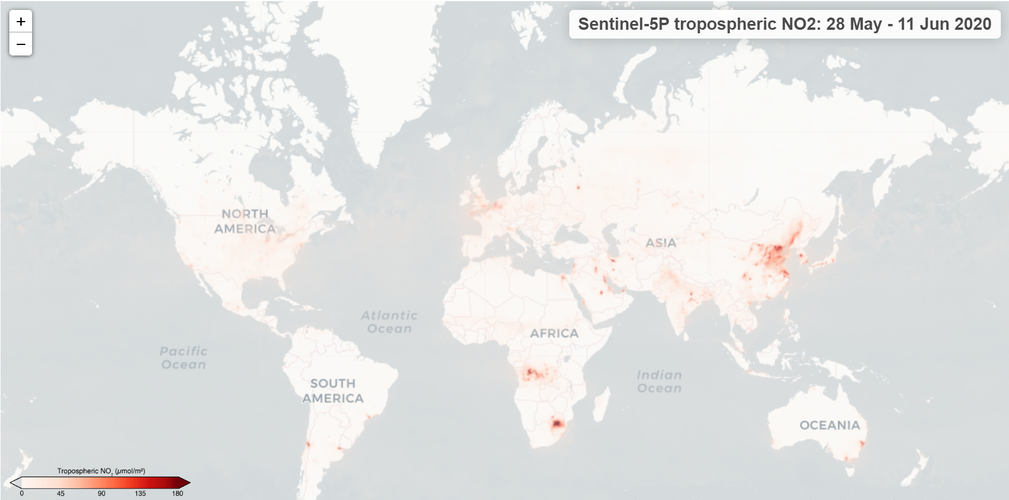 Image:
A new online platform that allows for the tracking of air pollution worldwide is now available to the public.
Image:
A new online platform that allows for the tracking of air pollution worldwide is now available to the public.
Global air pollution maps now available
11.6.2020 12:30 ESA Observing the Earth Image:
A new online platform that allows for the tracking of air pollution worldwide is now available to the public.
Image:
A new online platform that allows for the tracking of air pollution worldwide is now available to the public.
20200612 – volné místo – Ředitel/ka kanceláře ředitele katastrálního úřadu na KÚ pro Ústecký kraj
11.6.2020 11:39 ČÚZK - předpisy a opatření Katastrální úřad pro Ústecký kraj zveřejnil novou aktualitu: Nabídka volného pracovního místa - Ředitel / ředitelka kanceláře ředitele katastrálního úřadu na Katastrálním úřadu pro Ústecký kraj20200612 – volné místo – Ředitel/ka kanceláře ředitele katastrálního úřadu na KÚ pro Ústecký kraj
11.6.2020 11:39 ČÚZK /Urady/Katastralni-urady/Katastralni-urady/Katastralni-urad-pro-Ustecky-kraj/O-uradu/Aktuality/20200612-–-volne-misto-–-Reditel-ka-kancelare-rediInterview with Jen Kennedy, Senior Director, Sales North America, Airbus
11.6.2020 9:00 GISCafe.com Webcasts-WebinarsSkladník
11.6.2020 8:45 ČÚZK - předpisy a opatření Zeměměřický úřadvypisuje výběrové řízení na místo
Skladník
Skladník
11.6.2020 8:45 Zeměměřický úřad Zeměměřický úřadvypisuje výběrové řízení na místo
Skladník
Skladník
11.6.2020 8:45 ČÚZK - volná místa Zeměměřický úřad vypisuje výběrové řízení na místo SkladníkVýběrové řízení na služební místo odborný/vrchní referent - návrh zápisu v katastru – NZK1506
11.6.2020 7:00 ČÚZK /Urady/Katastralni-urady/Katastralni-urady/Katastralni-urad-pro-Plzensky-kraj/O-uradu/Aktuality/Vyberove-rizeni-na-sluzebni-misto-odborny-vrchniVýběrové řízení na služební místo odborný/vrchní referent - návrh zápisu v katastru – NZK1506
11.6.2020 7:00 ČÚZK - předpisy a opatření Katastrální úřad pro Plzeňský kraj - Katastrální pracoviště Tachov zveřejnil novou aktualitu: Ředitelka Katastrálního úřadu pro Plzeňský kraj vyhlašuje výběrové řízení na služební místoodborný/vrchní referent - návrh zápisu v katastru – NZK1506, Katastrální úřad pro Plzeňský kraj, Katastrální pracoviště Tachov.
Výběrové řízení na služební místo vrchní referent/rada - kontrola listin určených k záznamu – KL1501
11.6.2020 6:54 ČÚZK - předpisy a opatření Katastrální úřad pro Plzeňský kraj - Katastrální pracoviště Tachov zveřejnil novou aktualitu: Ředitelka Katastrálního úřadu pro Plzeňský kraj vyhlašuje výběrové řízení na služební místo vrchní referent/rada - kontrola listin určených k záznamu – KL1501, Katastrální úřad pro Plzeňský kraj, Katastrální pracoviště Tachov.Výběrové řízení na služební místo vrchní referent/rada - kontrola listin určených k záznamu – KL1501
11.6.2020 6:54 ČÚZK - předpisy a opatření Katastrální úřad pro Plzeňský kraj - Katastrální pracoviště Tachov zveřejnil novou aktualitu: Ředitelka Katastrálního úřadu pro Plzeňský kraj vyhlašuje výběrové řízení na služební místo vrchní referent/rada - kontrola listin určených k záznamu – KL1501, Katastrální úřad pro Plzeňský kraj, Katastrální pracoviště Tachov.Výběrové řízení na služební místo vrchní referent/rada - kontrola listin určených k záznamu – KL1501
11.6.2020 6:54 ČÚZK /Urady/Katastralni-urady/Katastralni-urady/Katastralni-urad-pro-Plzensky-kraj/O-uradu/Aktuality/Vyberove-rizeni-na-sluzebni-misto-vrchni-referentOdborný/vrchní referent - návrh zápisu v katastru – NZK1506
11.6.2020 6:47 ČÚZK - předpisy a opatření Katastrální úřad pro Plzeňský kraj Katastrální pracoviště Tachovvypisuje výběrové řízení na místo
Odborný/vrchní referent - návrh zápisu v katastru – NZK1506
Odborný/vrchní referent - návrh zápisu v katastru – NZK1506
11.6.2020 6:47 ČÚZK /Urady/Katastralni-urady/Katastralni-urady/Katastralni-urad-pro-Plzensky-kraj/Uredni-deska/Oznameni-a-jina-uredni-sdeleni/Volna-mista/DMS/Odborny-vrchni-referent-navrh-zapisu-v-katastruOdborný/vrchní referent - návrh zápisu v katastru – NZK1506
11.6.2020 6:47 ČÚZK - volná místa Katastrální úřad pro Plzeňský kraj Katastrální pracoviště Tachov vypisuje výběrové řízení na místo Odborný/vrchní referent - návrh zápisu v katastru – NZK1506Vrchní referent/rada - kontrola listin určených k záznamu – KL1501
11.6.2020 6:46 ČÚZK - volná místa Katastrální úřad pro Plzeňský kraj Katastrální pracoviště Tachov vypisuje výběrové řízení na místo Vrchní referent/rada - kontrola listin určených k záznamu – KL1501Vrchní referent/rada - kontrola listin určených k záznamu – KL1501
11.6.2020 6:46 ČÚZK /Urady/Katastralni-urady/Katastralni-urady/Katastralni-urad-pro-Plzensky-kraj/Uredni-deska/Oznameni-a-jina-uredni-sdeleni/Volna-mista/DMS/Vrchni-referent-rada-kontrola-listin-urcenych-kVrchní referent/rada - kontrola listin určených k záznamu – KL1501
11.6.2020 6:46 ČÚZK - předpisy a opatření Katastrální úřad pro Plzeňský kraj Katastrální pracoviště Tachovvypisuje výběrové řízení na místo
Vrchní referent/rada - kontrola listin určených k záznamu – KL1501
UP42 Launches Aerial Data Capabilities With Getmapping
11.6.2020 0:28 GISCafe.com Webcasts-Webinars UP42, a developer platform and marketplace for geospatial data and analytics today announced a new partnership with Getmapping Plc, the UK's leading …Bezplatně dostupný nástroj pro jazykovou korekturu odborných textů
11.6.2020 0:00 Geografický ústav MUInformace ze stránek knihovny Přírodovědecké knihovny:
Informujeme, že uživatelé MU mají až do 27. 6. 2020 možnost využít bezplatného přístupu k nástroji Writefull (https://writefull.com) pro jazykovou korekturu anglických odborných textů.
Služba je pro uživatele MU (přistupující z univerzitní počítačové sítě) dostupná na adresách:
- Writefull Revise: https://revise-muni-cz.writefull.ai
- Writefull Cite: https://cite-muni-cz.writefull.ai
Více informací na stránkách knihovny PřF: http://knihovna.sci.muni.cz/news
Více informací od produktu: https://www.aip.cz/produkty/3398-writefull
UNOOSA and UAE Space Agency announce agreement to advance space sustainability
10.6.2020 23:34 GISCafe.com Webcasts-Webinars VIENNA, 10 June (United Nations Information Service) — The United Nations Office for Outer Space Affairs (UNOOSA) and the United Arab …ProStar, the World Leader in Developing Precision Mapping Solutions, Has Been Granted Another Major U.S. Patent
10.6.2020 17:43 GISCafe.com Webcasts-Webinars GRAND JUNCTION, Colo. — (BUSINESS WIRE) — June 10, 2020 —United States Patent No. 9,619,573, prepared and prosecuted by Lewis …
Garmin® reveals the RV 890 GPS navigator
10.6.2020 16:30 GISCafe.com Webcasts-Webinars New 8-inch navigator with enhanced display and RV-specific featuresOLATHE, Kan. — (BUSINESS WIRE) — June 10, 2020 —
Garmin …
Accela Launches SaaS Migration Program to Help State and Local Government Customers Easily Move to the Cloud to Bolster Resiliency, Scalability, and Efficiency
10.6.2020 16:30 GISCafe.com Webcasts-Webinars New SaaS migration initiative gives governments a rapid, secure, and cost-effective way to achieve digitally-driven business continuity and …Trimble Offers New Solutions-as-a-Service Program for Remote Monitoring of Water and Wastewater Infrastructure
10.6.2020 16:30 GISCafe.com Webcasts-Webinars New Program Provides Utilities, Consultants and Service Providers with a Subscription Service, Combining Software, Wireless IoT Data Recorders and …Mapová aplikace ÚPD - nové dokumentace
10.6.2020 15:30 Jihočeský kraj V mapové aplikaci Územně plánovací dokumentace obcí byla aktualizována územně plánovací dokumentace obcí v ORP Prachatice – Bušanovice, Ktiš; ORP Trhové Sviny – Horní Stropnice; ORP Soběslav – Roudná, Skalice, Vesce, Tučapy.Univerzita Karlova ocenila nejlepší studenty a absolventy [Katedra aplikované geoinformatiky a kartografie, byTopic]
10.6.2020 14:00 Katedra aplikované geoinformatiky a kartografie Přf UK Ve Vlasteneckém sále byly předány Ceny rektora pro nejlepší absolventy Univerzity Karlovy, Mimořádné ceny rektora a Bolzanovy ceny podporující vědeckou výchovu a odbornou přípravu studentů Univerzity Karlovy. Mezi oceněnými byla i Tereza Kadeřábková, obhajující svou bakalářskou práci na katedře aplikované geoinformatiky a kartografie. Gratulujeme!Zeměměřický úřad hledá nové pracovníky
10.6.2020 11:55 Česká kartografická společnost Zeměměřický úřad vypsal výběrová řízení na pracovníky různého zaměření, včetně pozice kartografa. Podívejte se, jestli nehledají právě Vás… Podrobnosti na webových stránkách.Online webináře katedry geoinformatiky
10.6.2020 11:22 V průběhu dubna a května proběhly na katedře postupně 4 webináře pro studenty středních škol a širokou veřejnost. Pokud jste se některého z webinářů nemohli v daném čase zúčastnit, záznamy jsou dostupné na youtube kanále Hornicko-geologická fakulta, VŠB – TU Ostrava. https://www.youtube.com/channel/UCCqSwrXbuV5LF9Jd-xOQSlwOdborný referent v oddělení obnovy katastrálního operátu č. 3 na Technické sekci
10.6.2020 10:32 ČÚZK - předpisy a opatření Katastrální úřad pro Jihomoravský kraj technická sekcevypisuje výběrové řízení na místo
Odborný referent v oddělení obnovy katastrálního operátu č. 3 na Technické sekci
Odborný referent v oddělení obnovy katastrálního operátu č. 3 na Technické sekci
10.6.2020 10:32 ČÚZK - volná místa Katastrální úřad pro Jihomoravský kraj technická sekce vypisuje výběrové řízení na místo Odborný referent v oddělení obnovy katastrálního operátu č. 3 na Technické sekciOdborný referent v oddělení obnovy katastrálního operátu č. 3 na Technické sekci
10.6.2020 10:32 ČÚZK /Urady/Katastralni-urady/Katastralni-urady/Katastralni-urad-pro-Jihomoravsky-kraj/Uredni-deska/Oznameni-a-jina-uredni-sdeleni/Volna-mista/DMS/Odborny-referent-v-oddeleni-obnovy-katastralniho-oInterview with Brendan Hafferty, General Manager, FORUM8
10.6.2020 9:00 GISCafe.com Webcasts-WebinarsLesní hospodářský plán - ÚP Srní (LHC 383220)
10.6.2020 2:00 Cenia - Katalog metadat ČR - INSPIRE O všechny lesy ve vlastnictví státu je podle zákona o lesích č. 289/1995 Sb. pečováno na základě lesních hospodářských plánů nebo-li LHP. LHP jsou zákonným nástrojem pro vlastníka nebo správce státního majetku, který umožňuje efektivní péči o lesní majetek.LHP jsou vyhotoveny v souladu s § 24 a s využitím § 36 zákona č. 289/1995 Sb., o lesích a o změně a doplnění některých zákonů ve znění pozdějších předpisů (dále jen „zákon o lesích“), dle vyhlášky MZe č. 84/1996 Sb. o lesním hospodářském plánování. Obsahují náležitosti uvedené ve výše uvedených zákonných předpisech a předepsané přílohy. LHP jsou schvalována MŽP. Data LHP v datovém formátu XML jsou předávána do datového skladu ÚHÚL se sídlem v Brandýse nad Labem."Výsledkem je z hlediska digitálních GIS dat zejména - hospodářská kniha, grafická část LHPHospodářská kniha - popisuje stav lesa v jednotkách prostorového rozdělení lesa (JPRL) (tabulka s jednotlivými atributy)Grafická část - geografické znázornění JPRL v rastrové podobě (lesnická obrysová mapa porostní, lesnická mapa porostní - měřítko 1:10000)Rastrové podobě předchází vektorizace JPRL (porostní detail ve vektorové podobě s atributy vyjadřujcími zejména označení JPRL)Propojení hospodářské knihy s grafickou částí LHP je umožněno relačním způsobem.Bentley Systems’ Year in Infrastructure 2020 Conference is Going Digital!
10.6.2020 0:07 GISCafe.com Webcasts-Webinars Annual Event for Infrastructure Professionals and Thought Leaders Launches—Virtually—in OctoberEXTON, Pa. — (BUSINESS WIRE) — June …
Geospan Recruits CoreLogic Sr. Leader Andrew Zickell as CEO, and Moves Industry Into Remote Servicing and Next-Gen 4D Geospatial Solutions
9.6.2020 20:05 GISCafe.com Webcasts-Webinars President and Visual Geographic Information Pioneer Ted Lachinski Remains Onboard, Harnessing IP and Decades of IngenuityMINNEAPOLIS — …
Swift Navigation Demonstrates First-Ever Nationwide Lane-Level Precise Positioning With Ambitious Continental U.S. Drive Test
9.6.2020 20:05 GISCafe.com Webcasts-Webinars SAN FRANCISCO, June 09, 2020 (GLOBE NEWSWIRE) -- Swift Navigation, a San Francisco-based tech firm redefining GNSS and precise …Planet Announces 50cm SkySat Imagery, Tasking Dashboard and Up to 12x Revisit
9.6.2020 16:40 GISCafe.com Webcasts-Webinars SAN FRANCISCO, June 9, 2020 — (PRNewswire) — Planet, operator of history's largest commercial fleet of satellites, today announced …ZENRIN to join the HERE Marketplace
9.6.2020 16:40 GISCafe.com Webcasts-Webinars Japanese mapping company to offer its location data via global location data exchange hub from HEREAmsterdam, The Netherlands/Kitakyushu city, …Velodyne Lidar Announces Sales Agreement with AGROINTELLI
9.6.2020 16:40 GISCafe.com Webcasts-Webinars Velodyne Lidar Sensors Power AGROINTELLI’s Autonomous Farm VehiclesSAN JOSE, Calif. — (BUSINESS WIRE) — June 9, 2020 —
Velodyne …
Mapcom Systems Joins VertiGIS
9.6.2020 16:40 GISCafe.com Webcasts-Webinars LONDON — (BUSINESS WIRE) — June 9, 2020 —VertiGIS, a leading geographic information systems (GIS) solution provider and software …
AEye Reveals Advanced MEMS That Delivers Solid-State Performance and Reliability Needed to Advance Adoption of Low-Cost LiDAR
9.6.2020 16:40 GISCafe.com Webcasts-Webinars Independent tests validate that the new 4Sight™ long range intelligent MEMS-based sensor exceeds automotive and industrial standards for shock and …Weathering the Storm for Now: Mortgage Delinquencies Remain Low in March 2020 Despite Early Impacts of the Pandemic, CoreLogic Reports
9.6.2020 16:40 GISCafe.com Webcasts-Webinars The share of mortgages that transitioned from current to 30 days past due increased to 1% in March but remained below the 20-year average of …EOS Crop Monitoring update: track the soil moisture on your fields
9.6.2020 16:40 GISCafe.com Webcasts-Webinars MENLO PARK, Calif., June 9, 2020 — (PRNewswire) — EOS Crop Monitoring, a satellite crop monitoring platform, has launched an …Space synergies for food security
9.6.2020 16:18 European GNSS Agency
GNSS and Earth observation experts came together at a webinar organised by the European GNSS Agency (GSA) on 26 May to discuss how combining Galileo and EGNOS navigation and positioning tools with the data and services offered by EU Earth observation programme Copernicus can be used to improve food security and make agriculture in general more efficient and sustainable.
Disruptions caused by the COVID-19 pandemic have thrown the importance of our food supply chain into sharp focus. At the same time, synergies between positioning data from Galileo and EGNOS and Earth observation data from Copernicus offer huge untapped potential for making the agriculture sector more efficient, resilient and sustainable.
It was to explore this potential and to drive the use of space technology in the service of sustainable agriculture and a more secure food chain that the EO4AGRI H2020 project organised this webinar, in collaboration with GSA, targeted at students, researchers, data analysts, participants in European, national and international projects, service and application developers, and other stakeholders.
Early adopter
The agricultural sector was an early adopter of Europe’s satellite augmentation service EGNOS and over 95% of agricultural receivers in Europe are currently EGNOS-enabled, with more than 65% of receivers Galileo-enabled also. “Galileo plays a key role in precision agriculture not only in positioning but also when combined with other technologies such as Copernicus. The coming High Accuracy Service and Navigation Message Authentication will mean a turning point in smart farming applications”, said María-Eva Ramírez from the European GNSS Service Centre (GSC).
In agriculture, EGNOS-based solutions are used for low-value crop cultivation and low-accuracy operations such as ploughing, fertilizing and harvesting while Galileo receivers are used in a multi-constellation environment for high-value crop cultivation and precision operations such as sowing and transplanting. “EGNOS usage in European farming is a reality. Hundreds of thousands of cereal farmers benefit from free enhanced GPS accuracy. Thanks to EGNOS, crop productivity is increased and more sustainable farming is possible”, said Sofía Cilla from the European Satellite Service Provider (ESSP).
Watch this: European Satellites for Agriculture
“GNSS has become an integral part of smart, connected and integrated farm management solutions and is a key driver for precision farming across the whole crop cycle”, said Joaquín Reyes González, Market Development Technology Officer at the GSA.
Strength through synergy
But it is when EU GNSS and Earth observation services work in synergy that the benefits are most keenly felt. Synergies between EGNSS and Copernicus support a number of agriculture solutions, such as variable rate application, which enables the precise use of fertilisers and pesticides where and when they are most needed, thereby making the sector more resource-efficient and reducing its environmental footprint.
“We just scratched the surface of what is possible when these two core components are put into use operationally. The combination of these two European flagship space projects is a key enabler of the Farm to Fork Strategy, the core of the European Green Deal, allowing for a fair, healthy and environmentally-friendly food system in Europe and beyond”, said David Kolitzus from GeoVille Information Systems and Data Processing.
Read this: EGNSS and agriculture – a win-win relationship
EGNSS and Copernicus also enable soil moisture monitoring, providing timely information on water availability and reducing the amount of water used by linking it to the moisture level needed in the soil for a particular crop. Synergies between the two programmes also support the implementation of the Common Agricultural Policy, simplifying and digitising processes related to subsidies control and enabling more efficient checks. “EGNSS and Copernicus are core components in digital farming,” Reyes González said.
Webinar series
The May 26 webinar is the first in a series of webinars that will explore the benefits of EGNSS and Earth observation in the agriculture sector. All the presentations and video recording are now available here. A poll held at the event proposed two topics for future webinars: projects that showcase the use of EGNSS and Earth observation for agricultural applications, and technical tools for combining EGNSS and EO, with use cases from agriculture.
The vote was evenly split, so both these topics are likely to be the subjects of future webinars organised by the GSA. Stay tuned for updates!
Media note: This feature can be republished without charge provided the European GNSS Agency (GSA) is acknowledged as the source at the top or the bottom of the story. You must request permission before you use any of the photographs on the site. If you republish, we would be grateful if you could link back to the GSA website (http://www.gsa.europa.eu).
Bentley Systems’ Year in Infrastructure 2020 Conference is Going Digital!
9.6.2020 15:10 Bentley SystemsAnnual Event for Infrastructure Professionals and Thought Leaders
Launches—Virtually—in October
EXTON, Pa., USA – June 9, 2020 – Bentley Systems, Incorporated, a leading global provider of comprehensive software and digital twins services for advancing the design, construction, and operations of infrastructure, today announced that its annual infrastructure event, the Year in Infrastructure 2020 Conference, is “going digital.” This new digital format will bring together, now for a broader global community, the thought leadership, networking, and learning content that Bentley conference attendees have come to expect.
The virtual Year in Infrastructure 2020 Conference provides complementary access to a wide range of content relevant to infrastructure professionals in every role and at every phase of the infrastructure lifecycle. Highlights include:
Live Judging: Year in Infrastructure 2020 Awards Finalists’ Presentations – October 5 - 16
The Year in Infrastructure Awards finalists, chosen by independent juries of industry experts, present their projects to the judges beginning October 5. This is your chance to hear from the people behind the most extraordinary infrastructure projects of the year as they tell the story of how they leveraged digital advancements to achieve unprecedented outcomes.
Year in Infrastructure 2020 Executive Perspectives – October 20 - 21
Greg Bentley, CEO of Bentley Systems, will be joined by leading infrastructure executives for an interactive discussion on the resilience challenges they face and how to meet those challenges through digital advancement.
Keith Bentley, founder and chief technology officer, will discuss Bentley’s open strategy for digital twins. Keith will be joined by other leading industry visionaries who have deployed digital twins successfully for project delivery or asset performance.
TwinTalks Premiere – October 20
Infrastructure digital twins will be front and center at this year’s event. Join leading industry figures as they moderate six sector-specific TwinTalks, exploring the implications of digital twins for Digital Cities, Design and Construction, Digital Plants, Energy Utilities, Rail and Transit, and Roads and Bridges. Listen to interactive panel discussions with leading industry and business leaders and discover the fascinating opportunities that digital twins introduce for each of these critical infrastructure sectors. The initial October 20 TwinTalks are each part of a three-part series, with the second and third installments of the TwinTalks’ series scheduled through mid-November.
Year in Infrastructure 2020 Awards Ceremony – October 21
After months of jury deliberations, the winners of the Year in Infrastructure 2020 Awards will be announced in our live global broadcast. Don’t miss what has been called the “Academy Awards of Infrastructure.”
ACCELERATE Sessions – October 27 and beyond
Join Bentley product executives Dustin Parkman (Project Delivery), Robert Mankowski (Digital Cities), Ken Adamson (Design Integration), and Alan Kiraly (Asset and Network Performance) as they and their leadership teams review the latest advancements in Bentley applications and cloud services. These sessions will kick-off a multi-track program of more than 100 ACCELERATE sessions that will continue into November. ACCELERATE will feature Bentley and user experts in panel discussions and interactive demonstrations on the latest product advances, innovations, and best practice digital workflows.
Learn More about the Year in Infrastructure 2020 Conference
Join us online for the virtual Year in Infrastructure 2020 Conference and learn from peers, industry experts, and innovators who will share their infrastructure digital twins’ successes. Register for updates at https://yii.bentley.com/en.
Image: Year in Infrastructure 2020 Conference
Caption: The Year in Infrastructure 2020 Conference is Going Digital.
##
About Bentley Systems
Bentley Systems is a leading global provider of software solutions to engineers, architects, geospatial professionals, constructors, and owner-operators for the design, construction, and operations of infrastructure. Bentley’s MicroStation-based engineering and BIM applications, and its digital twin cloud services, advance the project delivery (ProjectWise) and the asset performance (AssetWise) of transportation and other public works, utilities, industrial and resources plants, and commercial and institutional facilities.
Bentley Systems employs more than 3,500 colleagues and generates annual revenues of more than $700 million in 172 countries. From inception in 1984, the company has remained majority-owned by its five founding Bentley brothers. www.bentley.com
Bentley, the Bentley logo, AssetWise, MicroStation, and ProjectWise are either registered or unregistered trademarks or service marks of Bentley Systems, Incorporated or one of its direct or indirect wholly owned subsidiaries. All other brands and product names are trademarks of their respective owners.
Bentley Systems’ Year in Infrastructure 2020 Conference is Going Digital!
9.6.2020 15:10 Bentley SystemsAnnual Event for Infrastructure Professionals and Thought Leaders
Launches—Virtually—in October
EXTON, Pa., USA – June 9, 2020 – Bentley Systems, Incorporated, a leading global provider of comprehensive software and digital twins services for advancing the design, construction, and operations of infrastructure, today announced that its annual infrastructure event, the Year in Infrastructure 2020 Conference, is “going digital.” This new digital format will bring together, now for a broader global community, the thought leadership, networking, and learning content that Bentley conference attendees have come to expect.
The virtual Year in Infrastructure 2020 Conference provides complementary access to a wide range of content relevant to infrastructure professionals in every role and at every phase of the infrastructure lifecycle. Highlights include:
Live Judging: Year in Infrastructure 2020 Awards Finalists’ Presentations – October 5 - 16
The Year in Infrastructure Awards finalists, chosen by independent juries of industry experts, present their projects to the judges beginning October 5. This is your chance to hear from the people behind the most extraordinary infrastructure projects of the year as they tell the story of how they leveraged digital advancements to achieve unprecedented outcomes.
Year in Infrastructure 2020 Executive Perspectives – October 20 - 21
Greg Bentley, CEO of Bentley Systems, will be joined by leading infrastructure executives for an interactive discussion on the resilience challenges they face and how to meet those challenges through digital advancement.
Keith Bentley, founder and chief technology officer, will discuss Bentley’s open strategy for digital twins. Keith will be joined by other leading industry visionaries who have deployed digital twins successfully for project delivery or asset performance.
TwinTalks Premiere – October 20
Infrastructure digital twins will be front and center at this year’s event. Join leading industry figures as they moderate six sector-specific TwinTalks, exploring the implications of digital twins for Digital Cities, Design and Construction, Digital Plants, Energy Utilities, Rail and Transit, and Roads and Bridges. Listen to interactive panel discussions with leading industry and business leaders and discover the fascinating opportunities that digital twins introduce for each of these critical infrastructure sectors. The initial October 20 TwinTalks are each part of a three-part series, with the second and third installments of the TwinTalks’ series scheduled through mid-November.
Year in Infrastructure 2020 Awards Ceremony – October 21
After months of jury deliberations, the winners of the Year in Infrastructure 2020 Awards will be announced in our live global broadcast. Don’t miss what has been called the “Academy Awards of Infrastructure.”
ACCELERATE Sessions – October 27 and beyond
Join Bentley product executives Dustin Parkman (Project Delivery), Robert Mankowski (Digital Cities), Ken Adamson (Design Integration), and Alan Kiraly (Asset and Network Performance) as they and their leadership teams review the latest advancements in Bentley applications and cloud services. These sessions will kick-off a multi-track program of more than 100 ACCELERATE sessions that will continue into November. ACCELERATE will feature Bentley and user experts in panel discussions and interactive demonstrations on the latest product advances, innovations, and best practice digital workflows.
Learn More about the Year in Infrastructure 2020 Conference
Join us online for the virtual Year in Infrastructure 2020 Conference and learn from peers, industry experts, and innovators who will share their infrastructure digital twins’ successes. Register for updates at https://yii.bentley.com/en.
##
Image: Year in Infrastructure 2020 Conference
Caption: The Year in Infrastructure 2020 Conference is Going Digital.
##
About Bentley Systems
Bentley Systems is a leading global provider of software solutions to engineers, architects, geospatial professionals, constructors, and owner-operators for the design, construction, and operations of infrastructure. Bentley’s MicroStation-based engineering and BIM applications, and its digital twin cloud services, advance the project delivery (ProjectWise) and the asset performance (AssetWise) of transportation and other public works, utilities, industrial and resources plants, and commercial and institutional facilities.
Bentley Systems employs more than 3,500 colleagues and generates annual revenues of more than $700 million in 172 countries. From inception in 1984, the company has remained majority-owned by its five founding Bentley brothers. www.bentley.com
Bentley, the Bentley logo, AssetWise, MicroStation, and ProjectWise are either registered or unregistered trademarks or service marks of Bentley Systems, Incorporated or one of its direct or indirect wholly owned subsidiaries. All other brands and product names are trademarks of their respective owners.
Galileo-enabled receivers soon in Prague tramways
9.6.2020 10:42 European GNSS Agency
The Prague Public Transit Company (DPP) has issued a tender for Galileo-enabled receivers to be included in Prague tramways as part of a modernization plan to increase network efficiency and improve user experience.
Prague has one of the largest tram fleets in Europe. The city's tramways are using a 20-year old system based on GPS-only. DPP has decided on a unique upgrade of their system to improve localization accuracy and provide vehicle positioning data to passengers. DPP Prague plans to buy Galileo-enabled, multifrequency, multiconstellation receivers for its entire tramway vehicle park. To develop the project, DPP cooperated with the Czech Technical University in Prague, the Czech Department for Transportation, the Municipality of Prague and the European GNSS Agency (GSA). The improvement in localization accuracy connected with the upgrade will bring important efficiency benefits to the DPP network such as a decrease in maintenance costs.
Satellite navigation in practice
"Space applications have a great potential for improving efficiency and safety across a wide variety of sectors and transport belongs to the largest users of space technologies. Galileo adoption in Prague tramways is a great example how to apply European satellite navigation in practice," said Karel Havlíček, Deputy Prime Minister, Czech Republic.
The receivers are planned to be deployed in the entire tram fleet (838 receivers are procured). DPP will be one of the first public transit companies to use Galileo in their entire fleet.
Read the Czech version here: Přijímače Galilea brzy v pražských tramvajích
"Public transport has to be comfortable and user friendly not only inside the vehicles and at the stops. We managed to provide real-time data about bus departures and their position on-line to passengers. For this year, we have promised to provide the same also for the tramways," said Adam Scheinherr, Deputy Mayor for Transport from the Municipality of Prague.
"Thanks to the new receivers and the possibility to use the European navigation system Galileo, we will be able to improve localization accuracy based on the tests that have been carried out so far down to 1.5 meters. Further, it will allow us to improve other systems used within DPP such as, for example, automatic speed limitation over the switches," added Petr Witowski, chairman of the board and executive director of DPP.
"Regarding the network extent and the quality of the transport service provided, Prague belongs to the top cities in the European Union. It shows therefore the recognition of Galileo efficiency that DPP plans to use Galileo within the whole tramway fleet as one of the first public transport operators in Europe," commented Pascal Claudel, Acting Executive Director of the European GNSS Agency.
DPP is expecting that the tender will be completed by the end of August 2020. The selected supplier will have to provide and install the receivers within the entire fleet of Prague tramways within 180 days from the contract signature. It is therefore expected that the First Galileo-enabled trams should be on track at the end of 2020.
Media note: This feature can be republished without charge provided the European GNSS Agency (GSA) is acknowledged as the source at the top or the bottom of the story. You must request permission before you use any of the photographs on the site. If you republish, we would be grateful if you could link back to the GSA website (http://www.gsa.europa.eu).
Galileo-enabled receivers soon in Prague tramways
9.6.2020 10:42 European GNSS AgencyThe Prague Public Transit Company (DPP) has issued a tender for Galileo-enabled receivers to be included in the Prague tramways as part of their modernization plan to increase network efficiency and improve user experience.
Prague has one of the largest tram fleets in Europe. Tramways are using a 20 years old system based on GPS-only. DPP has decided a unique upgrade of their system and intends to replace the current system to improve the localization accuracy and to provide vehicle positioning data to passengers. DPP Prague plans to buy Galileo-enabled, multifrequency, multiconstellation receivers for its entire Tramway vehicle park. To elaborate the project, DPP has cooperated with the Czech Technical University in Prague, the Czech Department for Transportation, the Municipality of Prague and with the European GNSS Agency (GSA). The improvement in localization accuracy connected with the upgrade will bring important efficiency benefits to the DPP network such as a decrease of the maintenance costs.
"Space applications have a great potential for improving efficiency and safety across a wide variety of sectors and transport belongs to the largest users of space technologies. Galileo adoption in Prague Tramways is a great example how to apply European satellite navigation in practice," underlined Karel Havlíček, Deputy Prime Minister, Czech Republic.
The receivers are planned to be deployed in the entire tram fleet (838 receivers are procured). DPP will be one of the first public transit companies to use Galileo in the entire tram fleet.
Read the Czech version here: Přijímače Galilea brzy v pražských tramvajích
"Public transport has to be comfortable and user friendly not only inside the vehicles and at the stops. We managed to provide real-time data about bus departures and their position on-line to passengers. For this year, we have promised to provide the same also for the tramways," said Adam Scheinherr, Deputy Mayor for Transport from Municipality of Prague
"Thanks to the new receivers and the possibility to use the European navigation system Galileo, we will be able to improve localization accuracy based on the test that have been carried out so far down to 1,5 meters. Further, it will allow us to improve other systems used within DPP, such as for example automatic speed limitation over the switches," added Petr Witowski, chairman of the board and executive director of DPP.
"Regarding the network extent and the quality of the transport service provided, Prague belongs to the top cities in the European Union. It shows therefore the recognition of Galileo efficiency that DPP plans to use Galileo within the whole Tramway fleet as one of the first public transport operators in Europe," commented Pascal Claudel, Acting Executive Director of the European GNSS Agency.
DPP is expecting that the competition will be completed by the end of August 2020. The selected supplier will have to provide and install the receivers within the entire fleet of Prague Tramways within 180 days from the contract signature. It is therefore expected that the First Galileo-enabled trams should be on track at the end of 2020.
Media note: This feature can be republished without charge provided the European GNSS Agency (GSA) is acknowledged as the source at the top or the bottom of the story. You must request permission before you use any of the photographs on the site. If you republish, we would be grateful if you could link back to the GSA website (http://www.gsa.europa.eu).
Galileo-enabled receivers soon in Prague tramways
9.6.2020 10:42 European GNSS AgencyThe Prague Public Transit Company (DPP) has issued a tender for Galileo-enabled receivers to be included in the Prague tramways as part of their modernization plan to increase network efficiency and improve user experience.
Prague has one of the largest tram fleets in Europe. Tramways are using a 20 years old system based on GPS-only. DPP has decided a unique upgrade of their system and intends to replace the current system to improve the localization accuracy and to provide vehicle positioning data to passengers. DPP Prague plans to buy Galileo-enabled, multifrequency, multiconstellation receivers for its entire Tramway vehicle park. To elaborate the project, DPP has cooperated with the Czech Technical University in Prague, the Czech Department for Transportation, the Municipality of Prague and with the European GNSS Agency (GSA). The improvement in localization accuracy connected with the upgrade will bring important efficiency benefits to the DPP network such as a decrease of the maintenance costs.
"Space applications have a great potential for improving efficiency and safety across a wide variety of sectors and transport belongs to the largest users of space technologies. Galileo adoption in Prague Tramways is a great example how to apply European satellite navigation in practice," underlined Karel Havlíček, Deputy Prime Minister, Czech Republic.
The receivers are planned to be deployed in the entire tram fleet (838 receivers are procured). DPP will be one of the first public transit companies to use Galileo in the entire tram fleet.
Read the czech version here: Přijímače Galilea brzy v pražských tramvajích
"Public transport has to be comfortable and user friendly not only inside the vehicles and at the stops. We managed to provide real-time data about bus departures and their position on-line to passengers. For this year, we have promised to provide the same also for the tramways," said Adam Scheinherr, Deputy Mayor for Transport from Municipality of Prague
"Thanks to the new receivers and the possibility to use the European navigation system Galileo, we will be able to improve localization accuracy based on the test that have been carried out so far down to 1,5 meters. Further, it will allow us to improve other systems used within DPP, such as for example automatic speed limitation over the switches," added Petr Witowski, chairman of the board and executive director of DPP.
"Regarding the network extent and the quality of the transport service provided, Prague belongs to the top cities in the European Union. It shows therefore the recognition of Galileo efficiency that DPP plans to use Galileo within the whole Tramway fleet as one of the first public transport operators in Europe," commented Pascal Claudel, Acting Executive Director of the European GNSS Agency.
DPP is expecting that the competition will be completed by the end of August 2020. The selected supplier will have to provide and install the receivers within the entire fleet of Prague Tramways within 180 days from the contract signature. It is therefore expected that the First Galileo-enabled trams should be on track at the end of 2020.
Media note: This feature can be republished without charge provided the European GNSS Agency (GSA) is acknowledged as the source at the top or the bottom of the story. You must request permission before you use any of the photographs on the site. If you republish, we would be grateful if you could link back to the GSA website (http://www.gsa.europa.eu).
Interview with Tom Turchioe, HANA CoE Spatial Expert and Evangelist, SAP
9.6.2020 9:00 GISCafe.com Webcasts-WebinarsAndré Trudel named president of Korem's new Business Consulting division
9.6.2020 9:00 GISCafe.com Webcasts-Webinars André Trudel, a well known figure in the fields of business development and high performance management, is joining Korem as President of the …Parking in a pandemic
9.6.2020 8:35 ESA Observing the Earth
The coronavirus pandemic has brought the tourism and travel industry to a near-standstill, with nationwide lockdowns significantly impacting the aviation and maritime industry worldwide. Satellite images, captured by the Copernicus Sentinel-2 mission, show parked aircraft and anchored vessels in times of COVID-19.
V Olomouci tvoří teplotní mapu města – zapojte se i Vy!
9.6.2020 8:30 GISportal.cz
Během horkých letních dnů lidé v Olomouci z některých míst spěchají a na jiná naopak cíleně míří, aby se vyhnuli největšímu horku. Výzkumníci z katedry geografie a katedry rozvojových a environmentálních studií (obě PřF UP) si vzali za cíl sestavit pocitovou teplotní mapu Olomouce, která pomůže při návrhu efektivních opatření ke snížení stresu z tepla […]
The post V Olomouci tvoří teplotní mapu města – zapojte se i Vy! appeared first on GISportal.cz.
Pocitová teplotní mapa Olomouce
9.6.2020 7:00 Česká asociace pro geoinformace Katedra geografie a Katedra rozvojových a environmentálních studií Přírodovědecké fakulty Univerzity Palackého v Olomouci ve spolupráci s Magistrátem města Olomouc nově připravuje teplotní mapu Olomouce. Výzkum navazuje na bioklimatickou analýzu teplotních poměrů města a jeho cílem je návrh efektivních opatření ke snížení teplotního stresu ve městě během horkýchElistair Unveils the SAFE-T 2, The New Standard for Tethered Drone Stations
8.6.2020 22:28 GISCafe.com Webcasts-Webinars LYON, France — (BUSINESS WIRE) — June 8, 2020 —Elistair has announced the release of the Safe-T 2, their most advanced and …
Post-doc position in the MIning MUlti-source and MUlti-modal geo-referenced information (MIMU) project
8.6.2020 19:27 Post-doc position in Portugal Innovative geographic knowledge discovery is becoming increasingly possible through the analysis of large-scale data, for instance made available by Earth observation projects leveraging satellites and remote-sensing, provided by ground-level sensors, or given as volunteered geographical information (e.g., geo-referenced multimedia contents posted online on social media platforms). However, problems that involve combining […]Interview with Damon Ogando, Regional Sales Manager, Handheld Group
8.6.2020 17:50 GISCafe.com Webcasts-WebinarsMedia Alert: BlackSky to Provide Satellite Images of Black Lives Matter Protest in Washington, D.C.
8.6.2020 17:41 GISCafe.com Webcasts-Webinars (BUSINESS WIRE) — June 5, 2020 —
View source version on businesswire.com: …
CyberTech is First Esri Partner to be Awarded ArcGIS Cloud Services Specialty Designation
8.6.2020 17:41 GISCafe.com Webcasts-Webinars OAK BROOK, Ill., June 8, 2020 — (PRNewswire) — CyberTech Systems and Software Inc. today announced CyberTech's recognition as …Odborný referent – zápisy v řízení V a Z v oddělení právních vztahů k nemovitostem Katastrálního pra
8.6.2020 14:12 ČÚZK - předpisy a opatření Katastrální úřad pro Zlínský kraj Katastrální pracoviště Uherský Brodvypisuje výběrové řízení na místo
Odborný referent – zápisy v řízení V a Z v oddělení právních vztahů k nemovitostem Katastrálního pracoviště Uherský Brod