


![]()

zprávy
zdroje zpráv:rada/odborný rada – právník Katastrálního úřadu pro hlavní
23.6.2020 15:31 ČÚZK - předpisy a opatření Katastrální úřad pro hlavní město Prahu - Katastrální pracoviště Prahavypisuje výběrové řízení na místo
rada/odborný rada – právník Katastrálního úřadu pro hlavní
rada/odborný rada – právník
23.6.2020 15:31 ČÚZK - předpisy a opatření Katastrální úřad pro hlavní město Prahu - Katastrální pracoviště Prahavypisuje výběrové řízení na místo
rada/odborný rada – právník
rada/odborný rada – právník
23.6.2020 15:31 ČÚZK /Urady/Katastralni-urady/Katastralni-urady/Katastralni-urad-pro-hlavni-mesto-Prahu/Uredni-deska/Oznameni-a-jina-uredni-sdeleni/Volna-mista/DMS/rada-odborny-rada-–-pravnik-Katastralniho-uradu-prrada/odborný rada – právník Katastrálního úřadu pro hlavní
23.6.2020 15:31 ČÚZK - volná místa Katastrální úřad pro hlavní město Prahu - Katastrální pracoviště Praha vypisuje výběrové řízení na místo rada/odborný rada – právník Katastrálního úřadu pro hlavnírada/odborný rada – právník
23.6.2020 15:31 ČÚZK - volná místa Katastrální úřad pro hlavní město Prahu - Katastrální pracoviště Praha vypisuje výběrové řízení na místo rada/odborný rada – právníkrada/odborný rada - právník
23.6.2020 15:08 ČÚZK - předpisy a opatření Katastrální úřad pro hlavní město Prahu Katastrální pracoviště Prahavypisuje výběrové řízení na místo
rada/odborný rada - právník
Oznámení o plánované výluce telekomunikačních služeb dne 16.07.2020
23.6.2020 14:45 ČÚZK - předpisy a opatření Katastrální úřad pro Jihomoravský kraj - Katastrální pracoviště Znojmo zveřejnil novou aktualitu:Oznámení o plánované výluce telekomunikačních služeb dne 16.07.2020
Oznámení o plánované výluce telekomunikačních služeb dne 16.07.2020
23.6.2020 14:45 ČÚZK /Urady/Katastralni-urady/Katastralni-urady/Katastralni-urad-pro-Jihomoravsky-kraj/Katastralni-pracoviste/KP-Znojmo/O-uradu/Aktuality/Oznameni-o-planovane-vyluce-telekomunikacnich-(1)Robert Mankowski, SVP of Digital Cities, Bentley Systems, Joins the Executive Board of the World Geospatial Industry Council
23.6.2020 14:31 Bentley SystemsEXTON, Pa. – June 23, 2020 – Bentley Systems, Incorporated, a leading global provider of comprehensive software and digital twin cloud services for advancing the design, construction, and operations of infrastructure, announces that Robert Mankowski, Bentley’s senior vice president of digital cities, has been named to the executive board of the World Geospatial Industry Council.
Mankowski leads Bentley’s digital cities solution area, which provides infrastructure engineering, digital twin software, and services to help cities that are going digital. He has over 20 years’ experience in software development and has co-invented several technologies now used in the OpenFlows product line. Bentley’s digital cities applications enable engineers to plan and design more efficient city infrastructure.
“I am honored to serve on the WGIC executive board and use my experience and knowledge of both the geospatial industry and the infrastructure industry to further advance WGIC’s mission and objectives,” said Mankowski.
Mankowski joined Bentley in 2004 as part of Bentley’s acquisition of Haestad Methods, a pioneer in object-oriented hydraulic analysis software, where he served as chief technology officer. He earned a Bachelor of Science degree in civil engineering from Drexel University and is a licensed professional engineer.
Mankowski replaces Ted Lamboo on the World Geospatial Industry Council board. Formerly with Bentley, Lamboo is now CEO of Digital Construction Works, a new digital automation, integration, and digital twinning services and fit-for-purpose solutions company formed as part of a joint venture between Bentley and Topcon Positioning Group.
Bentley is a co-founder of the World Geospatial Industry Council, which acts as a collaborative platform for advancing the role of the geospatial industry and strengthening its contributions to society and the world economy.
Mankowski is one of four new members the World Geospatial Industry Council named to its executive board. More information about the appointments is available here.
Image: Robert Mankowski
Caption: Robert Mankowski, Bentley’s senior vice president of digital cities, was recently appointed to the executive board of the World Geospatial Industry Council.
##
About WGIC
The World Geospatial Industry Council is a registered not-for-profit trade association of commercial geospatial companies representing the entire value chain of the geospatial ecosystem. For more information about WGIC, visit: https://wgicouncil.org/
About Bentley Systems
Bentley Systems is a leading global provider of software solutions to engineers, architects, geospatial professionals, constructors, and owner-operators for the design, construction, and operations of infrastructure. Bentley’s MicroStation-based engineering and BIM applications, and its digital twin cloud services, advance the project delivery (ProjectWise) and the asset performance (AssetWise) of transportation and other public works, utilities, industrial and resources plants, and commercial and institutional facilities.
Bentley Systems employs more than 3,500 colleagues and generates annual revenues of more than $700 million in 172 countries. From inception in 1984, the company has remained majority-owned by its five founding Bentley brothers. www.bentley.com
Bentley, the Bentley logo, AssetWise, Haestad Methods, MicroStation, OpenFlows, and ProjectWise are either registered or unregistered trademarks or service marks of Bentley Systems, Incorporated or one of its direct or indirect wholly owned subsidiaries. All other brands and product names are trademarks of their respective owners.
Oznámení o plánované výluce telekomunikačních služeb.
23.6.2020 13:05 ČÚZK - předpisy a opatření Katastrální úřad pro Jihomoravský kraj - Katastrální pracoviště Znojmo zveřejnil novou aktualitu: Oznámení o plánované výluce telekomunikačních služeb dne 13.07.2020.Podrobnosti zde
Oznámení o plánované výluce telekomunikačních služeb.
23.6.2020 13:05 ČÚZK /Urady/Katastralni-urady/Katastralni-urady/Katastralni-urad-pro-Jihomoravsky-kraj/Katastralni-pracoviste/KP-Znojmo/O-uradu/Aktuality/Oznameni-o-planovane-vyluce-telekomunikacnich-sluzNedostupnost WSDP na zkoušku od čtvrtka 25.6.2020 do pátku 26.6.2020
23.6.2020 12:20 ČÚZK - předpisy a opatření Vážení uživatelé webových služeb,oznamujeme, že od čtvrtka 25.6.2020 od 8 hodin do pátku 26.6.2020 do cca 20 hodin nebudou dostupné webové služby na zkoušku.
Omlouváme se za komplikace a děkujeme za pochopení.
Nedostupnost WSDP na zkoušku od čtvrtka 25.6.2020 do pátku 26.6.2020
23.6.2020 12:20 ČÚZK /Aplikace-DP-do-KN/Aplikace-DP-do-KN/Archiv-DP/292831Nedostupnost WSDP na zkoušku od čtvrtka 25.6.2020 do úterka 30.6.2020
23.6.2020 12:20 Dálkový přístup k údajům KN ČR Vážení uživatelé webových služeb,oznamujeme, že od čtvrtka 25.6.2020 od 8 hodin do úterka 30.6.2020 do cca 20 hodin nebudou dostupné webové služby na zkoušku.
Omlouváme se za komplikace a děkujeme za pochopení.
Nedostupnost WSDP na zkoušku od čtvrtka 25.6.2020 do úterka 30.6.2020
23.6.2020 12:20 ČÚZK /Aplikace-DP-do-KN/Aplikace-DP-do-KN/Archiv-DP/292831Nedostupnost WSDP na zkoušku od čtvrtka 25.6.2020 do pátku 26.6.2020
23.6.2020 12:20 Dálkový přístup k údajům KN ČR Vážení uživatelé webových služeb,oznamujeme, že od čtvrtka 25.6.2020 od 8 hodin do pátku 26.6.2020 do cca 20 hodin nebudou dostupné webové služby na zkoušku.
Omlouváme se za komplikace a děkujeme za pochopení.
Nedostupnost WSDP na zkoušku od čtvrtka 25.6.2020 do úterka 30.6.2020
23.6.2020 12:20 ČÚZK - předpisy a opatření Vážení uživatelé webových služeb,oznamujeme, že od čtvrtka 25.6.2020 od 8 hodin do úterka 30.6.2020 do cca 20 hodin nebudou dostupné webové služby na zkoušku.
Omlouváme se za komplikace a děkujeme za pochopení.
[Webinar Recording] New Features Overview in Satsurv 2.0.3 to 2.0.4
23.6.2020 10:39 Satlab GeosolutionsSatLab Webinar-30th June, 2020 Topics covered in this w […]
The post [Webinar Recording] New Features Overview in Satsurv 2.0.3 to 2.0.4 appeared first on SatLab – Global Satellite Positioning Solutions.
【Webinar Recording】 New Features Overview in Satsurv 2.0.3 to 2.0.4
23.6.2020 10:39 Satlab GeosolutionsSatLab Webinar-30th June, 2020 What to expect in this Webinar: 1. Tips for Project Management 2. New Features in Surveying and Staking out Interface 3. Introduction of Different Tilt Survey Modes of SatLab Receivers Presenter: Lukasz Migda Country manager of SatLab Geosolutions in Poland
The post 【Webinar Recording】 New Features Overview in Satsurv 2.0.3 to 2.0.4 appeared first on Satlab – Global Satellite Positioning Solutions.
[Webinar Recording] New Features Overview in Satsurv 2.0.3 to 2.0.4
23.6.2020 10:39 Satlab GeosolutionsSatLab Webinar-30th June, 2020 Topics covered in this webinar: 1. Tips for Project Management 2. New Features in Surveying and Staking out Interface 3. Introduction of Different Tilt Survey Modes of SatLab Receivers Presenter: Lukasz Migda Country manager of SatLab Geosolutions in Poland
The post [Webinar Recording] New Features Overview in Satsurv 2.0.3 to 2.0.4 appeared first on Satlab – Global Satellite Positioning Solutions.
[Webinar Recording] New Features Overview in Satsurv 2.0.3 to 2.0.4
23.6.2020 10:39 Satlab GeosolutionsSatLab Webinar-30th June, 2020 Topics covered in this webinar: 1. Tips for Project Management 2. New Features in Surveying and Staking out Interface 3. Introduction of Different Tilt Survey Modes of SatLab Receivers Presenter: Lukasz Migda Country manager of SatLab Geosolutions in Poland
The post [Webinar Recording] New Features Overview in Satsurv 2.0.3 to 2.0.4 appeared first on SatLab – Global Satellite Positioning Solutions.
[Webinar Recording] New Features Overview in Satsurv 2.0.3 to 2.0.4
23.6.2020 10:39 Satlab GeosolutionsSatLab Webinar-30th June, 2020 The outline of this webinar: 1. Tips for Project Management 2. New Features in Surveying and Staking out Interface 3. Introduction of Different Tilt Survey Modes of SatLab Receivers Presenter: Lukasz Migda Country manager of SatLab Geosolutions in Poland
The post [Webinar Recording] New Features Overview in Satsurv 2.0.3 to 2.0.4 appeared first on Satlab – Global Satellite Positioning Solutions.
[Webinar Recording] New Features Overview in Satsurv 2.0.3 to 2.0.4
23.6.2020 10:39 Satlab GeosolutionsSatLab Webinar-30th June, 2020 Topics covered in this w […]
The post [Webinar Recording] New Features Overview in Satsurv 2.0.3 to 2.0.4 appeared first on Satlab – Global Satellite Positioning Solutions.
[Webinar Recording] New Features Overview in Satsurv 2.0.3 to 2.0.4
23.6.2020 10:39 Satlab GeosolutionsSatLab Webinar-30th June, 2020 Topics covered in this webinar: 1. Tips for Project Management 2. New Features in Surveying and Staking out Interface 3. Introduction of Different Tilt Survey Modes of SatLab Receivers Presenter: Lukasz Migda Country manager of SatLab Geosolutions in Poland
The post [Webinar Recording] New Features Overview in Satsurv 2.0.3 to 2.0.4 appeared first on Satlab – Global Satellite Positioning Solutions.
[Webinar Recording] New Features Overview in Satsurv 2.0.3 to 2.0.4
23.6.2020 10:39 Satlab GeosolutionsSatLab Webinar-30th June, 2020 Topics covered in this w […]
The post [Webinar Recording] New Features Overview in Satsurv 2.0.3 to 2.0.4 appeared first on Satlab – Global Satellite Positioning Solutions.
【Webinar Recording】 New Features Overview in Satsurv 2.0.3 to 2.0.4
23.6.2020 10:39 Satlab GeosolutionsSatLab Webinar-30th June, 2020 The outline of this webinar: 1. Tips for Project Management 2. New Features in Surveying and Staking out Interface 3. Introduction of Different Tilt Survey Modes of SatLab Receivers Presenter: Lukasz Migda Country manager of SatLab Geosolutions in Poland
The post 【Webinar Recording】 New Features Overview in Satsurv 2.0.3 to 2.0.4 appeared first on Satlab – Global Satellite Positioning Solutions.
referent KN – vedení DKM, vedení katastrální mapy
23.6.2020 10:27 ČÚZK - předpisy a opatření Katastrální úřad pro hlavní město Prahu - Katastrální pracoviště Prahavypisuje výběrové řízení na místo
referent KN – vedení DKM, vedení katastrální mapy
referent KN – vedení DKM, vedení katastrální mapy
23.6.2020 10:27 ČÚZK /Urady/Katastralni-urady/Katastralni-urady/Katastralni-urad-pro-hlavni-mesto-Prahu/Uredni-deska/Oznameni-a-jina-uredni-sdeleni/Volna-mista/DMS/referent-KN-–-vedeni-DKM,-vedeni-katastralni-mapyreferent KN – vedení DKM, vedení katastrální mapy
23.6.2020 10:27 ČÚZK - volná místa Katastrální úřad pro hlavní město Prahu - Katastrální pracoviště Praha vypisuje výběrové řízení na místo referent KN – vedení DKM, vedení katastrální mapyBurlington Hydro Deploys Hexagon Advanced Utility GIS Solutions to Manage Electricity Network
23.6.2020 10:00 Hexagon Safety & Infrastructure Network management tools will enable utility to maintain location-based information and share vital GIS data across the organization.Burlington Hydro Deploys Hexagon Advanced Utility GIS Solutions to Manage Electricity Network
23.6.2020 10:00 Hexagon Safety & Infrastructure Network management tools will enable utility to maintain location-based information and share vital GIS data across the organization.【SatLab Webinar】The Detailed Overview and Narration for Road in Satsurv
23.6.2020 9:53 Satlab GeosolutionsSatLab Webinar-7th July, 2020 What to expect in this Webinar: 1. Introduction of Road in Satsurv 2. Designing of Road in Satsurv 3. How to Carry out Road Stake Outs in Satsurv Presenter: Mubashir Mushtaq Sales & Application Manager of SatLab Geosolutions
The post 【SatLab Webinar】The Detailed Overview and Narration for Road in Satsurv appeared first on Satlab – Global Satellite Positioning Solutions.
【SatLab Webinar】Satsurv in Civil Engineering
23.6.2020 9:34 Satlab GeosolutionsSatLab Webinar-2nd July, 2020 What to expect in this Webinar: 1. Common information checking and setting tips 2. Quasi-dynamic survey 3. Tilt survey 4. Static & PPK 5. Stake out Presenter: Niki Wong Senior Technical Engineer of SatLab Geosolutions
The post 【SatLab Webinar】Satsurv in Civil Engineering appeared first on Satlab – Global Satellite Positioning Solutions.
Satsurv in Civil Engineering
23.6.2020 9:34 Satlab GeosolutionsSatLab Webinar-2nd July, 2020 What to expect in this Webinar: 1. Common information checking and setting tips 2. Quasi-dynamic survey 3. Tilt survey 4. Static & PPK 5. Stake out Presenter: Niki Wong Senior Technical Engineer of SatLab Geosolutions
The post Satsurv in Civil Engineering appeared first on Satlab – Global Satellite Positioning Solutions.
Satellite positioning: a game changer for the European Railway Traffic Management System
23.6.2020 9:29 European GNSS Agency
A Work Plan for the European Railway Traffic Management System (ERTMS), published by the European Commission in May this year, lists satellite positioning as one of the game changing technologies underpinning future evolutions of the system and a key element to be included in future Technological Specifications for Interoperability (TSI).
The ERTMS is a major industrial project that aims to make rail transport in Europe safer and more competitive. As a safety system, the ERTMS enforces train compliance with speed restrictions and signalling and consists of equipment installed both on trains and along the railway tracks.
According to the latest Work Plan, the ERTMS will become the backbone of railway digitalisation in Europe, allowing for the introduction of new technologies, including but not limited to automatic train operation, satellite positioning and other technologies capable of optimising rail performance and capacity.
Positive cost benefits
“In light of the important role that GNSS positioning will play in the system, the GSA recently conducted a cost-benefit analysis for virtual balises, one of the possible technical solutions for the ERTMS,” said Daniel Lopour, Market Development manager for rail. “This analysis showed that there is a positive cost/benefit ratio, both for railway infrastructure managers and for the industry as a whole,” he said.
Read this: ITT: EGNSS-based rail safety service analysis
The GSA report found that, to make a good economic case, a rail line must be in a location that enables the deployment of a large number of virtual balises, when physical balises have not yet been deployed. The cost of balise maintenance also has an impact on the attractiveness of the project: the maintenance cost per physical balise should be high to allow for more cost savings.
One of the guiding principles for the future evolution of the ERTMS, including the revision of the Control Command and Signalling (CCS) Technological Specifications for Interoperability (TSI) planned for 2022, is to ensure that the TSI will deliver significant business case improvements for the railway sector. For this to happen, and to achieve higher capacity and better performance, the ERTMS game changers should be included in the TSI revision.
Investing in the future
Within the framework of Horizon 2020, the GSA and the Shift2Rail Joint Undertaking have been investing to ensure that Galileo and EGNOS can support localisation objectives within the ERTMS. R&D projects such as ERSAT, STARS and X2RAIL2, for example, have helped to analyse the rail environment, define the necessary architecture of the train positioning subsystem and provide the first operational pilots, transferring early results to European tracks.
Watch this: EGNOS and Galileo for Rail
To support the ERTMS Work Plan the GSA, together with European Space Agency (ESA), is also actively supporting railway companies, infrastructure managers and the EU railway industry from the technical perspective regarding the different GNSS services needed for fail-safe train localisation.
The GSA will continue to collaborate with Shift2Rail and the European Railway Agency on the necessary changes to ERTMS and the relevant European GNSS services, with the ultimate goal of delivering GNSS-based localisation-related efficiency benefits to the future evolutions of the ERTMS.
Media note: This feature can be republished without charge provided the European GNSS Agency (GSA) is acknowledged as the source at the top or the bottom of the story. You must request permission before you use any of the photographs on the site. If you republish, we would be grateful if you could link back to the GSA website (http://www.gsa.europa.eu).
Satellite positioning a game changer for the European Railway Traffic Management System
23.6.2020 9:29 European GNSS AgencyA Work Plan for the European Railway Traffic Management System (ERTMS), published by the European Commission in May this year, lists satellite positioning as one of the game changing technologies underpinning future evolutions of the system and a key element to be included in future Technological Specifications for Interoperability (TSI).
The ERTMS is a major industrial project that aims to make rail transport in Europe safer and more competitive. As a safety system, the ERTMS enforces train compliance with speed restrictions and signalling and consists of equipment installed both on trains and along the railway tracks.
According to the latest Work Plan, the ERTMS will become the backbone of railway digitalisation in Europe, allowing for the introduction of new technologies, including but not limited to automatic train operation, satellite positioning and other technologies capable of optimising rail performance and capacity.
Positive cost benefits
“In light of the important role that GNSS positioning will play in the system, the GSA recently conducted a cost-benefit analysis for virtual balises, one of the possible technical solutions for the ERTMS,” said Daniel Lopour, Market Development manager for rail. “This analysis showed that there is a positive cost/benefit ratio, both for railway infrastructure managers and for the industry as a whole,” he said.
Read this: ITT: EGNSS-based rail safety service analysis
The GSA report found that, to make a good economic case, a rail line must be in a location that enables the deployment of a large number of virtual balises, when physical balises have not yet been deployed. The cost of balise maintenance also has an impact on the attractiveness of the project: the maintenance cost per physical balise should be high to allow for more cost savings.
One of the guiding principles for the future evolution of the ERTMS, including the revision of the Control Command and Signalling (CCS) Technological Specifications for Interoperability (TSI) planned for 2022, is to ensure that the TSI will deliver significant business case improvements for the railway sector. For this to happen, and to achieve higher capacity and better performance, the ERTMS game changers should be included in the TSI revision.
Investing in the future
Within the framework of Horizon 2020, the GSA and the Shift2Rail Joint Undertaking have been investing to ensure that Galileo and EGNOS can support localisation objectives within the ERTMS. R&D projects such as ERSAT, STARS and X2RAIL2, for example, have helped to analyse the rail environment, define the necessary architecture of the train positioning subsystem and provide the first operational pilots, transferring early results to European tracks.
Watch this: EGNOS and Galileo for Rail
To support the ERTMS Work Plan the GSA, together with European Space Agency (ESA), is also actively supporting railway companies, infrastructure managers and the EU railway industry from the technical perspective regarding the different GNSS services needed for fail-safe train localisation.
The GSA will continue to collaborate with Shift2Rail and the European Railway Agency on the necessary changes to ERTMS and the relevant European GNSS services, with the ultimate goal of delivering GNSS-based localisation-related efficiency benefits to the future evolutions of the ERTMS.
Media note: This feature can be republished without charge provided the European GNSS Agency (GSA) is acknowledged as the source at the top or the bottom of the story. You must request permission before you use any of the photographs on the site. If you republish, we would be grateful if you could link back to the GSA website (http://www.gsa.europa.eu).
Satellite positioning, a game changer for the European Railway Traffic Management System
23.6.2020 9:29 European GNSS AgencyA Work Plan for the European Railway Traffic Management System (ERTMS), published by the European Commission in May this year, lists satellite positioning as one of the game changing technologies underpinning future evolutions of the system and a key element to be included in future Technological Specifications for Interoperability (TSI).
The ERTMS is a major industrial project that aims to make rail transport in Europe safer and more competitive. As a safety system, the ERTMS enforces train compliance with speed restrictions and signalling and consists of equipment installed both on trains and along the railway tracks.
According to the latest Work Plan, the ERTMS will become the backbone of railway digitalisation in Europe, allowing for the introduction of new technologies, including but not limited to automatic train operation, satellite positioning and other technologies capable of optimising rail performance and capacity.
Positive cost benefits
“In light of the important role that GNSS positioning will play in the system, the GSA recently conducted a cost-benefit analysis for virtual balises, one of the possible technical solutions for the ERTMS,” said Daniel Lopour, Market Development manager for rail. “This analysis showed that there is a positive cost/benefit ratio, both for railway infrastructure managers and for the industry as a whole,” he said.
Read this: ITT: EGNSS-based rail safety service analysis
The GSA report found that, to make a good economic case, a rail line must be in a location that enables the deployment of a large number of virtual balises, when physical balises have not yet been deployed. The cost of balise maintenance also has an impact on the attractiveness of the project: the maintenance cost per physical balise should be high to allow for more cost savings.
One of the guiding principles for the future evolution of the ERTMS, including the revision of the Control Command and Signalling (CCS) Technological Specifications for Interoperability (TSI) planned for 2022, is to ensure that the TSI will deliver significant business case improvements for the railway sector. For this to happen, and to achieve higher capacity and better performance, the ERTMS game changers should be included in the TSI revision.
Investing in the future
Within the framework of Horizon 2020, the GSA and the Shift2Rail Joint Undertaking have been investing to ensure that Galileo and EGNOS can support localisation objectives within the ERTMS. R&D projects such as ERSAT, STARS and X2RAIL2, for example, have helped to analyse the rail environment, define the necessary architecture of the train positioning subsystem and provide the first operational pilots, transferring early results to European tracks.
Watch this: EGNOS and Galileo for Rail
To support the ERTMS Work Plan the GSA, together with European Space Agency (ESA), is also actively supporting railway companies, infrastructure managers and the EU railway industry from the technical perspective regarding the different GNSS services needed for fail-safe train localisation.
The GSA will continue to collaborate with Shift2Rail and the European Railway Agency on the necessary changes to ERTMS and the relevant European GNSS services, with the ultimate goal of delivering GNSS-based localisation-related efficiency benefits to the future evolutions of the ERTMS.
Media note: This feature can be republished without charge provided the European GNSS Agency (GSA) is acknowledged as the source at the top or the bottom of the story. You must request permission before you use any of the photographs on the site. If you republish, we would be grateful if you could link back to the GSA website (http://www.gsa.europa.eu).
COVID-19 data sources
23.6.2020 9:09 Katedra geoinformatiky UP OlomoucVít Pászto, Jaroslav Burian a Karel Macků publikovali v časopise Geografie článek, ve kterém v souvislosti s pandemickou situací COVID19 hodnotí mapové aplikace a analyzují změny v chování obyvatel Evropy na základě dat Google Community Moblity Reports. Článek si můžete přečíst na: https://geografie.cz/media/pdf/geo_2020125020171.pdf
The post COVID-19 data sources appeared first on Katedra geoinformatiky.
Pasportizace sportovišť - I. etapa - Výsledky
23.6.2020 9:00 Středočeský kraj Byla publikována nová mapová aplikace Pasportizace sportovišť ve Středočeském kraji - I. etapa, která nabízí základní informace o sportovištích zmapovaných na území Středočeského kraje. Kromě polohopisu jsou jimi např. název, rok vzniku, rok rekonstrukce, týdenní návštěvnost, využitelnost školami, výčet sportovních aktivit, ale i informace o povrchu sportoviště, a v neposlední řadě i subjektivní hodnocení respondentů současného stavu s možností zobrazit fotografii. Jedná se o pilotní projekt, který byl realizován v návaznosti na strategický dokument v oblasti sportu Plán rozvoje sportu ve Středočeském kraji – Koncepce sportovní politiky Středočeského kraje 2018 C– 2025. Cílem pasportizace je zmapovat, kde a v jakém stavu se nachází sportoviště ve Středočeském kraji. Získaná data budou sloužit k efektivnějšímu zacílení krajské podpory a to jak vhodnou volbou tematických zadání Fondu sportu, tak zacílení podpory do oblastí, kde zjištěné informace poukazují na nedostatečné nebo nevyhovující sportovní zázemí. Díky zástupcům obcí, spolků a dalších subjektů se podařilo nasbírat přes 900 sportovišť. Pomocí nástrojů geografických informačních systémů byla data také analyzována. Z dosavadních výsledků lze vyčíst, která místa jsou pravděpodobně poddimenzována, která sportoviště potřebují rekonstrukci a další informace. Jako podklad pro II. etapu bylo vlastními silami zmapováno dalších 900 sportovišť. Aplikace je vlastní iniciativou Středočeského kraje a připravil ji Odbor informatiky / GIS ve spolupráci s Odborem regionálního rozvoje. Více o projektu ZDE. Aplikace je optimalizována primárně pro aktuální verze webových prohlížečů Mozilla Firefox a Google Chrome.TATRANSKÝ [NE]PORIADOK
23.6.2020 7:00 Česká asociace pro geoinformace Nová jednoduchá mapová aplikace s názvem TATRANSKÝ [NE]PORIADOK zobrazuje přístupné a nepřístupné turistické stezky v Tatranskom národnom parku. Cílem autora - Jakuba Rusnáka, je přeložit návštěvní pořádek TANAP-u do srozumitelné vizuální podoby. Aplikace nabízí volby mezi pěti různými sporty spolu s textovým popisem a časovou linií platnosti omezení.Mapu
Mapillary Joins Facebook on the Journey of Improving Maps Everywhere
23.6.2020 2:35 GISCafe.com Webcasts-Webinars Today we're announcing that Mapillary has joined Facebook on the quest to improve maps everywhere and for everyone.Jan Erik Solem
18 Jun …
 Získejte licenci Fusion 360 za polovinu ceny.
Pozemkové úpravy, zelená krajina a trvalo udržateľný život na vidieku
22.6.2020 19:57 Komora pozemkových úprav SR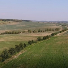
Dňa 3.7.2020 sa v Nýrovciach konal pracovný seminár za účasti ministra pôdohospodárstva
Pozemkové úpravy, zelená krajina a trvalo udržateľný život na vidieku
22.6.2020 19:57 Komora pozemkových úprav SRKPÚ SR organizuje pracovný seminár pod záštitou ministra pôdohospodárstva
Pozemkové úpravy, zelená krajina a trvalo udržateľný život na vidieku
22.6.2020 19:57 Komora pozemkových úprav SRKPÚ SR organizuje pracovný seminár za účasti ministra pôdohospodárstva
Maxar Selected to Deliver Multi-Domain Analytics System for U.S. Department of Homeland Security
22.6.2020 15:15 GISCafe.com Webcasts-Webinars WESTMINSTER, Colo. — (BUSINESS WIRE) — June 22, 2020 —Maxar Technologies (NYSE:MAXR) (TSX:MAXR), a trusted partner and innovator …
LeoStella Delivers First BlackSky Satellites from its New Production Line
22.6.2020 15:15 GISCafe.com Webcasts-Webinars Rapid low-cost manufacturing of high-quality satellites is a realityTUKWILA, Wash. — (BUSINESS WIRE) — June 22, 2020 —
LeoStella, …
Microdrones Enters the Third Dimension with New Mapping and LiDAR Surveying Equipment
22.6.2020 15:15 GISCafe.com Webcasts-Webinars Rome, NY, June 22, 2020 (GLOBE NEWSWIRE) -- Microdrones has enjoyed a strong spring “growing season” with the launch of the popular Microdrones …20200623 – volné místo - Vrchní/odborný referent v OOO II. v TO KÚ pro Ústecký kraj
22.6.2020 14:18 ČÚZK /Urady/Katastralni-urady/Katastralni-urady/Katastralni-urad-pro-Ustecky-kraj/O-uradu/Aktuality/20200623-–-volne-misto-Vrchni-odborny-referent-v20200623 – volné místo - Vrchní/odborný referent v OOO II. v TO KÚ pro Ústecký kraj
22.6.2020 14:18 ČÚZK - předpisy a opatření Katastrální úřad pro Ústecký kraj zveřejnil novou aktualitu: Nabídka volného pracovního místa - Vrchní / odborný referent v oddělení obnovy katastrálního operátu II. v technickém odboru na Katastrálním úřadu pro Ústecký krajDavid Rumsey Map Center: Inside One of the World's Biggest Map Collections [Knihovna geografie, byTopic]
22.6.2020 12:40 Katedra aplikované geoinformatiky a kartografie Přf UK Zajímavé video z Rumsey Map CenterVýstava Poklady Mapové sbírky v Horním Slavkově [Knihovna geografie, byTopic]
22.6.2020 10:50 Katedra aplikované geoinformatiky a kartografie Přf UK Výstava Poklady Mapové sbírky je nyní k vidění v Muzeu v Horním Slavkově (Pluhova č. 211) denně v čase 9.00 – 12.00 a 12.30 – 17.00 až do 25. 8. 2020.Červnový mapathon v Praze (pozvánka)
22.6.2020 8:57 GISportal.cz
30. června se bude v Praze (Vlkova 36, Praha 3) po dlouhé době konat mapathon – nebude virtuální, ale opravdový, takže se můžete těšit na setkání a pokec. Akce se koná od 18:00 do 20:30. Na mapathonu budeme společně podle satelitních snímků v OpenStreetMap digitalizovat budovy pro map pro týmy Lékařů bez hranic v terénu. […]
The post Červnový mapathon v Praze (pozvánka) appeared first on GISportal.cz.
Další termíny školení
22.6.2020 2:00 VARS.czZáklady práce v GIS se zaměřením na ArcGIS for Desktop 8.–10. 9. 2020
Rozšíření kvalifikace pro práci v GIS se zaměřením na ArcGIS for Desktop 22.–23. 9. 2020
Další termíny školení
22.6.2020 2:00 VARS.czZáklady práce v GIS se zaměřením na ArcGIS for Desktop 8.–10. 9. 2020
Rozšíření kvalifikace pro práci v GIS se zaměřením na ArcGIS for Desktop 22.–23. 9. 2020
Omezení provozu Pobočky Mladá Boleslav
22.6.2020 0:00 Státní pozemkový úřad Z důvodu trvání havárie vodovodního řadu a s ní spojené přerušení dodávky pitné vody do budovy Ministerstva zemědělství v Mladé Boleslavi, kde sídlí i naše Pobočka Mladá Boleslav, je od 22. 6. 2020 provoz této pobočky přerušen, a to do odvolání. Děkujeme za pochopení.Harmonogram státních závěrečných zkoušek - bakalářské studium (červen 2020)
22.6.2020 0:00 Geografický ústav MUHarmonogram SZZ pro bakalářské studium (červen 2020) je ke stažení ZDE.
Harmonogram státních závěrečných zkoušek - bakalářské studium
22.6.2020 0:00 Geografický ústav MUByl zvěřejněn harmonogram státních závěrečných zkoušek Bc. studia.
Harmonogram státních závěrečných zkoušek - bakalářské studium
22.6.2020 0:00 Geografický ústav MUByl zvěřejněn harmonogram státních závěrečných zkoušek Bc. studia.
Omezení provozu Pobočky Mladá Boleslav
22.6.2020 0:00 Státní pozemkový úřad Z důvodu trvání havárie vodovodního řadu a s ní spojené přerušení dodávky pitné vody do budovy Ministerstva zemědělství v Mladé Boleslavi, kde sídlí i naše Pobočka Mladá Boleslav, je od 22. 6. 2020 provoz této pobočky přerušen, a to do odvolání. Děkujeme za pochopení.Symboly FRANKE pro TurboCAD/DAEX
20.6.2020 11:33 ŠPINAR - softwareZdarma knihovna symbolů FRANKE ke stažení pro program TurboCAD v26 a DAEX Generator v20. Knihovna obsahuje 3D modely dřezů, baterií, digestoří, odpadkových košů a dávkovačů jaru včetně textur. Symboly nejsou určeny pro funkci „Skládání dle vektoru“. Ukázka vybraných prvků z knihovny FRANKE: SYMBOLY FRANKE ke stažení zde
The post Symboly FRANKE pro TurboCAD/DAEX appeared first on ŠPINAR – software.
Symboly FRANKE pro TurboCAD/DAEX
20.6.2020 11:33 ŠPINAR - software Zdarma knihovna symbolů FRANKE ke stažení pro program TurboCAD v26 a DAEX Generator v20. Knihovna obsahuje 3D modely dřezů, baterií, digestoří, odpadkových košů a dávkovačů jaru včetně textur. Symboly nejsou určeny pro funkci „Skládání dle vektoru“. Ukázka vybraných prvků z knihovny FRANKE: SYMBOLY FRANKE ke stažení zdeURISA's Vanguard Cabinet Announces the 2020 University Student and Young Professional Digital Competition
19.6.2020 20:29 GISCafe.com Webcasts-Webinars Des Plaines, IL (June 19, 2020) URISA's Vanguard Cabinet is pleased to announce the details for the 2020 University Student and Young …Compliance testing is now available for implementations of the ‘OGC GML in JPEG 2000 (GMLJP2) Part 1: Core’ encoding standard
19.6.2020 20:28 GISCafe.com Webcasts-Webinars Products that implement the GMLJP2 standard can now be tested and certified as OGC Compliant.19 June 2020: The Open Geospatial Consortium (OGC) …
Esri users gain access to international public transport data from TravelTime
19.6.2020 19:52 GISCafe.com Webcasts-Webinars Knight Frank among early users of newly available data18 June 2020 – Esri UK today announced that partner TravelTime (previously iGeolise) …
Innovative project reaches new depths despite global pandemic
19.6.2020 19:52 GISCafe.com Webcasts-Webinars A North East water company has continued to innovate and progress a ground-breaking safety project, despite being in the middle of a global …National Underground Asset Register (NUAR) Project nominated for Digital Collaboration Award
19.6.2020 19:52 GISCafe.com Webcasts-Webinars Project now moving into Phase 2Cambridge, UK, 18th June 2020, (www.1spatial.com) 1Spatial, the global geospatial software, solutions and business …
Pantomime's Reality Faucet with Liquid LiDAR for 2020 iPad Pros Brings Realistic Physics to Augmented Reality
19.6.2020 16:33 GISCafe.com Webcasts-Webinars Pantomime Corporation has today launched the Reality Faucet augmented reality app which, on Apple's iPad Pro 2020 models, uses new LiDAR depth …PlanetObserver Announces Release of Updated Global Imagery Basemap
19.6.2020 16:33 GISCafe.com Webcasts-Webinars PlanetObserver provides geospatial data for several professionals applications such as military or civil solutions.We are proud to announce the …
Rajant and Velodyne Lidar Support Portwide Autonomy for DGWorld's ITVs at DP World’s Largest Port
19.6.2020 16:33 GISCafe.com Webcasts-Webinars M2M Wireless and Lidar Integral to Jebel Ali Port Automation by DGWorldSAN JOSE, Calif. — (BUSINESS WIRE) — June 19, 2020 …
Microdrones Invites You to Play the Ultimate Surveying Game Show: SURVEYOR SAYS.
19.6.2020 16:33 GISCafe.com Webcasts-Webinars Rome, NY, June 19, 2020 (GLOBE NEWSWIRE) -- Microdrones is hosting the ultimate Surveying Game Show, SURVEYOR SAYS, intended to test contestants on …Woolpert, Centric Consulting Helping Local Governments Access and Maximize CARES Act Funding
19.6.2020 16:33 GISCafe.com Webcasts-Webinars The partnership provides data, management and organizational support to help municipalities apply for and receive financial relief in the wake of …20200619-VŘ Správce RÚIAN
19.6.2020 15:08 ČÚZK - předpisy a opatření Český úřad zeměměřický a katastrální zveřejnil novou aktualitu: Oznámení o vyhlášení výběrového řízení na obsazení služebního místa odborný rada - Správce RÚIAN.Správce RÚIAN
19.6.2020 14:59 ČÚZK - předpisy a opatření Český úřad zeměměřický a katastrálnívypisuje výběrové řízení na místo
Správce RÚIAN
Správce RÚIAN
19.6.2020 14:59 ČÚZK - volná místa Český úřad zeměměřický a katastrální vypisuje výběrové řízení na místo Správce RÚIANSprávce RÚIAN
19.6.2020 14:59 ČÚZK /Urady/Cesky-urad-zememericky-a-katastralni/Uredni-deska/Oznameni-a-jina-uredni-sdeleni/Volna-mista/DMS/Spravce-RUIANvrchní referent / rada v oddělení podpory ICT v technickém odboru
19.6.2020 13:29 ČÚZK - předpisy a opatření Katastrální úřad pro Liberecký krajvypisuje výběrové řízení na místo
vrchní referent / rada v oddělení podpory ICT v technickém odboru
vrchní referent / rada v oddělení podpory ICT v technickém odboru
19.6.2020 13:29 ČÚZK - volná místa Katastrální úřad pro Liberecký kraj vypisuje výběrové řízení na místo vrchní referent / rada v oddělení podpory ICT v technickém odboruvrchní referent / rada v oddělení podpory ICT v technickém odboru
19.6.2020 13:29 ČÚZK /Urady/Katastralni-urady/Katastralni-urady/Katastralni-urad-pro-Liberecky-kraj/Uredni-deska/Oznameni-a-jina-uredni-sdeleni/Volna-mista/vrchni-referent-rada-v-oddeleni-podpory-ICT-v-tPřipravili jsme verze 14.73 našich produktů
19.6.2020 12:46 GEPROPublikovali jsme verze 14.73 našich produktů MISYS, MISYS-WEB – licenční server, KOKEŠ, Geoportál GEPRO i PROLAND.… >>
Krátkodobé přerušení provozu DP a WSDP v pátek 19.6. od 20:00 do cca 20:30.
19.6.2020 12:27 ČÚZK /Aplikace-DP-do-KN/Aplikace-DP-do-KN/Archiv-DP/292598Krátkodobé přerušení provozu DP a WSDP v pátek 19.6. od 20:00 do cca 20:30.
19.6.2020 12:27 ČÚZK - předpisy a opatření Vážení uživatelé,Z provozních důvodů dojde v pátek 19.6. od 20:00 do cca 20:30 ke krátkodobému přerušení provozu Dálkového přístupu i Webových služeb dálkového přístupu.
Za komplikace tímto způsobené se omlouváme a děkujeme za pochopení.
Krátkodobé přerušení provozu DP a WSDP v pátek 19.6. od 20:00 do cca 20:30.
19.6.2020 12:27 Dálkový přístup k údajům KN ČR Vážení uživatelé,Z provozních důvodů dojde v pátek 19.6. od 20:00 do cca 20:30 ke krátkodobému přerušení provozu Dálkového přístupu i Webových služeb dálkového přístupu.
Za komplikace tímto způsobené se omlouváme a děkujeme za pochopení.
Rada/odborný rada v oddělení aktualizace GI KN na Katastrálním pracovišti Brno - město
19.6.2020 11:54 ČÚZK /Urady/Katastralni-urady/Katastralni-urady/Katastralni-urad-pro-Jihomoravsky-kraj/Uredni-deska/Oznameni-a-jina-uredni-sdeleni/Volna-mista/DMS/Rada-odborny-rada-v-oddeleni-aktualizace-GI-KN-naRada/odborný rada v oddělení aktualizace GI KN na Katastrálním pracovišti Brno - město
19.6.2020 11:54 ČÚZK - předpisy a opatření Katastrální úřad pro Jihomoravský kraj Katastrální pracoviště Brno-městovypisuje výběrové řízení na místo
Rada/odborný rada v oddělení aktualizace GI KN na Katastrálním pracovišti Brno - město
Rada/odborný rada v oddělení aktualizace GI KN na Katastrálním pracovišti Brno - město
19.6.2020 11:54 ČÚZK - volná místa Katastrální úřad pro Jihomoravský kraj Katastrální pracoviště Brno-město vypisuje výběrové řízení na místo Rada/odborný rada v oddělení aktualizace GI KN na Katastrálním pracovišti Brno - město【SatLab Webinar】 New Features Overview in Satsurv 2.0.3 to 2.0.4
19.6.2020 11:45 Satlab GeosolutionsSatLab Webinar-30th June, 2020 What to expect in this Webinar: 1. Tips for Project Management 2. New Features in Surveying and Staking out Interface 3. Introduction of Different Tilt Survey Modes of SatLab Receivers Presenter: Lukasz Migda Country manager of SatLab Geosolutions in Poland
The post 【SatLab Webinar】 New Features Overview in Satsurv 2.0.3 to 2.0.4 appeared first on Satlab – Global Satellite Positioning Solutions.
【SatLab Webinar】 New Features Overview in Satsurv 2.0.3 to 2.0.4
19.6.2020 11:45 Satlab GeosolutionsSatLab Webinar-30th June, 2020 What to expect in this Webinar: 1. Tips for Project Management 2. New Features in Surveying and Staking out Interface 3. Introduction of Different Tilt Survey Modes of SatLab Receivers Presenter: Lukasz Migda Country manager of SatLab Geosolutions in Poland
The post 【SatLab Webinar】 New Features Overview in Satsurv 2.0.3 to 2.0.4 appeared first on Satlab – Global Satellite Positioning Solutions.
【SatLab Webinar】 New features overview in Satsurv 2.0.3 to 2.0.4
19.6.2020 11:45 Satlab GeosolutionsSatLab Webinar-30th June, 2020 What to expect in this Webinar: 1. Tips for Project Management 2. New Features in Surveying and Staking out Interface 3. Introduction of Different Tilt Survey Modes of SatLab Receivers Presenter: Lukasz Migda Country manager of SatLab Geosolutions in Poland
The post 【SatLab Webinar】 New features overview in Satsurv 2.0.3 to 2.0.4 appeared first on Satlab – Global Satellite Positioning Solutions.
Oddělení hospodářské správy - pracovní poměr - domovník
19.6.2020 11:22 ČÚZK - volná místa Katastrální úřad pro Jihočeský kraj kancelář ředitele vypisuje výběrové řízení na místo Oddělení hospodářské správy - pracovní poměr - domovníkOddělení hospodářské správy - pracovní poměr - domovník
19.6.2020 11:22 ČÚZK - předpisy a opatření Katastrální úřad pro Jihočeský kraj kancelář ředitelevypisuje výběrové řízení na místo
Oddělení hospodářské správy - pracovní poměr - domovník
Oddělení hospodářské správy - pracovní poměr - domovník
19.6.2020 11:22 ČÚZK /Urady/Katastralni-urady/Katastralni-urady/Katastralni-urad-pro-Jihocesky-kraj/Volna-mista/DMS/Oddeleni-hospodarske-spravy-pracovni-pomer-domEarth from Space: Great Rift Valley, Kenya
19.6.2020 10:00 ESA Observing the Earth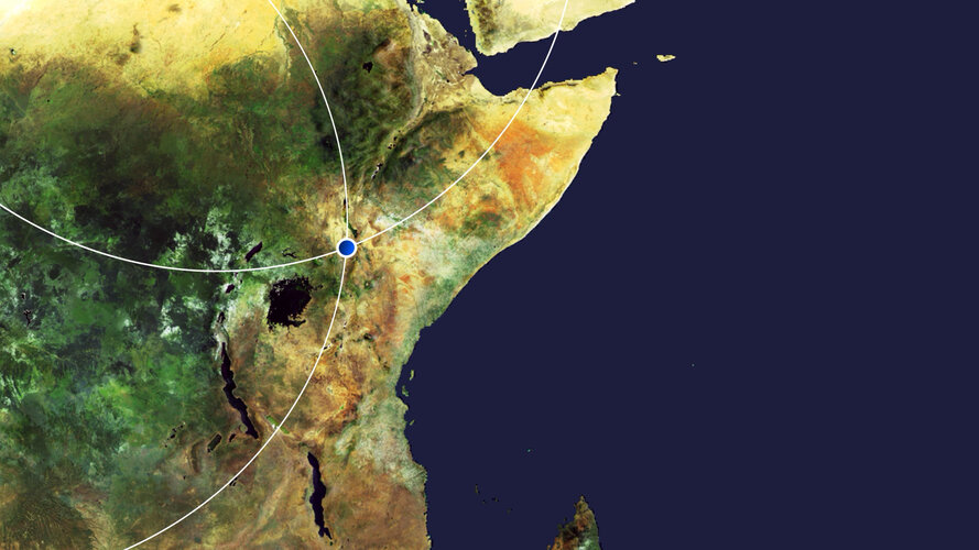 Video:
00:00:00
Video:
00:00:00
In this week's edition of the Earth from Space programme, the Copernicus Sentinel-2 mission takes us over part of the Great Rift Valley, Kenya.
See also Great Rift Valley, Kenya to download the image.
Great Rift Valley, Kenya
19.6.2020 10:00 ESA Observing the Earth Image:
The Copernicus Sentinel-2 mission takes us over part of the Great Rift Valley, Kenya.
Image:
The Copernicus Sentinel-2 mission takes us over part of the Great Rift Valley, Kenya.
Earth from Space: Great Rift Valley, Kenya
19.6.2020 10:00 ESA Observing the Earth Video:
00:00:00
Video:
00:00:00
In this week's edition of the Earth from Space programme, the Copernicus Sentinel-2 mission takes us over part of the Great Rift Valley, Kenya.
See also Great Rift Valley, Kenya to download the image.
Great Rift Valley, Kenya
19.6.2020 10:00 ESA Observing the Earth Image:
The Copernicus Sentinel-2 mission takes us over part of the Great Rift Valley, Kenya.
Image:
The Copernicus Sentinel-2 mission takes us over part of the Great Rift Valley, Kenya.
Travis Bodin, PLS, PMP Named Vice President of Fenstermaker's Survey & Mapping Division
19.6.2020 9:00 GISCafe.com Webcasts-Webinars Lafayette, LA, June 18, 2020 (GLOBE NEWSWIRE) -- C. H. Fenstermaker & Associates, L.L.C. has announced the promotion of Travis Bodin, PLS, PMP …Katastrální mapa ve formátech DGN a DXF poskytovaná v e-shopu
19.6.2020 2:00 Cenia - Katalog metadat ČR - INSPIRE Katastrální mapa je závazným státním mapovým dílem velkého měřítka, obsahuje body polohového bodového pole, polohopis a popis. Katastrální mapa ve vektorové podobě je poskytována zdarma ve formátu DGN a DXF a obsahuje prvky Digitální katastrální mapy (DKM) a Katastrální mapy digitalizované (KMD), tedy bodová pole, budovy, další prvky mapy, hranice parcel, katastrální hranice, parcely katastru nemovitostí, prvky orientační mapy a hranice věcného břemene. Z důvodu použití formátu DGN produkt neobsahuje značky na liniích a oblouky jsou nahrazeny lomenými čárami. Katastrální mapa ve vektorové podobě k 15. 06. 2020 pokrývá 96,81% území České republiky, t.j. 76 347,80km2. Více katastrální vyhláška č.357/2013 Sb. v platném znění.INSPIRE téma Budovy (BU)
19.6.2020 2:00 Cenia - Katalog metadat ČR - INSPIRE Data odpovídají směrnici INSPIRE pro téma budovy (BU). Data pochází částečně z projektu RÚIAN (Registr územní identifikace, adres a nemovitostí), který je součástí základních registrů České Republiky a obsahuje informace o územní identifikaci, adresách a nemovitostech, a částečně z ISKN (Informační systém katastru nemovistostí). Zdrojem informací o budovách v ISKN je objekt Stavba, v RÚIAN je to Stavební objekt. Většina Staveb je zároveň Stavebními objekty, ale jsou případy, kdy tomu tak není. Kromě Budov datová sada obsahuje i části budov, které jsou pro potřeby INSPIRE vyjádřeny vchody z RÚIAN. Vchody obsahují informace o počtu podlaží, technickoekonomických atributech apod. Datová sada pokrývá celé území české republiky. V datové sadě není uvedeno 1,14%, t.j. 48344 budov (k 15. 06. 2020), protože neobsahují definiční bod ani polygon. Více v zákoně č. 111/2009 Sb., o základních registrech, ve vyhlášce č. 359/2011 Sb., o základním registru územní identifikace, adres a nemovitostí v platných zněních, v zákoně 256/2013 Sb., o katastru nemovitostí, v katastrální vyhlášce č. 357/2013 Sb. v platném znění a INSPIRE Data Specification on Buildings v 3.0 z 13.12.2013. Data ve formátu GML 3.2.1 jsou validní proti schématu XML pro INSPIRE téma Budovy ve verzi 4.0 a proti schématu pro prostorová data ELF ve verzi 1.0.INSPIRE téma Adresy (AD)
19.6.2020 2:00 Cenia - Katalog metadat ČR - INSPIRE Data odpovídají směrnici INSPIRE pro téma adresy (AD). Vychází především z projektu RÚIAN (Registr územní identifikace, adres a nemovitostí), který je součástí základních registrů České Republiky a obsahuje informace o územní identifikaci, adresách a nemovitostech. Data publikovaná v rámci INSPIRE obsahují pouze adresní místa a jejich komponenty, kterými jsou stát, obec, část obce, městský obvod v Praze (MOP), městký obvod/městská část (MO/MČ), ulice a pošta a to na území celé České Republiky. Obsahují rozvněž geometrii, která určuje definiční bod adresního místa. V datové sadě nění uvedeno 1,14%, t.j. 33528 adresních míst (k 15. 06. 2020), protože neobsahují definiční bod, podle kterého by je bylo možné prostorově určit. Více v zákoně č. 111/2009 Sb., o základních registrech a ve vyhlášce č. 359/2011 Sb., o základním registru územní identifikace, adres a nemovitostí v platných zněních a INSPIRE Data Specification on Addresses v 3.0.1 z 26.4.2010. Data ve formátu GML 3.2.1 jsou validní proti schématu XML pro INSPIRE téma Adresy ve verzi 4.0 a proti schématu pro prostorová data ELF ve verzi 1.0.INSPIRE téma Rozšířené Parcely (CPX)
19.6.2020 2:00 Cenia - Katalog metadat ČR - INSPIRE Rozšíření má za cíl poskytovat katastrální mapu s obsahem podle vyhlášky ve vektorové podobě ve struktuře plně v souladu se strukturou danou směrnicí INSPIRE. Data rozšiřují směrnici INSPIRE pro téma katastrální parcely (CP) o věcná břemena, geodetické body, další prvky mapy, původní obloukovou geometrii a o parcely určené definičním bodem (ty pouze v oblastech s analogovou mapou). Vychází z katastrální mapy, která je závazným státním mapovým dílem velkého měřítka, obsahuje body polohového bodového pole, polohopis a popis a může mít formu digitální mapy, analogové mapy nebo digitalizované mapy. Publikovaná data obsahují katastrální území pro celou Českou Republiku, parcely a jejich hranice, věcná břemena, další prvky mapy a původní obloukovou geometrii z území, kde je digitální mapa (k 15. 06. 2020 je to 96,81% území České republiky, t.j. 76 347,80km2) a ve zbytku území katastrální parcely určené pouze definičním bodem (tedy bez hranic a polygonu). Katastrální parcely a hranice obsahují oproti datové sadě INSPIRE některé atributy navíc. Jedná se o typ hranice, způsob využití území, druh pozemku, vazbu na budovu a o mapové značky. Více katastrální zákon 344/1992 SB., katastrální vyhláška č.26/2007 Sb. v platném znění a INSPIRE Data Specification on Cadastral Parcels v 3.0.1. Data ve formátu GML 3.2.1 jsou validní proti schématu XML pro Rozšířené Parcely (CPX) ve verzi 4.0.INSPIRE téma Parcely (CP)
19.6.2020 2:00 Cenia - Katalog metadat ČR - INSPIRE Data odpovídají směrnici INSPIRE pro téma katastrální parcely (CP). Vychází z katastrální mapy, která je závazným státním mapovým dílem velkého měřítka, obsahuje body polohového bodového pole, polohopis a popis a může mít formu digitální mapy, analogové mapy nebo digitalizované mapy. Data publikovaná v rámci INSPIRE obsahují pouze katastrální území (pro celou Českou Republiku) a parcely a jejich hranice z území, kde je digitální mapa (k 15. 06. 2020 je to 96,81% území České republiky, t.j. 76 347,80km2). Více katastrální zákon 344/1992 SB., katastrální vyhláška č.26/2007 Sb. v platném znění a INSPIRE Data Specification on Cadastral Parcels v 3.0.1. Data ve formátu GML 3.2.1 jsou validní proti schématu XML pro INSPIRE téma Parcely ve verzi 4.0 a proti schématu pro prostorová data ELF ve verzi 1.0.Saudi Arabia Launches COVID-19 Dashboard Using Esri Technology
19.6.2020 0:52 GISCafe.com Webcasts-Webinars The Country's Ministry of Health Is Tracking Pandemic Cases with New GIS ResourcesREDLANDS, Calif. — (BUSINESS WIRE) — June 18, 2020 …
Před pouhým půl rokem dokončené poldry ochránily Kobeřice před 30letou vodou
19.6.2020 0:00 Státní pozemkový úřad Praha, 19. 6. 2020: Realizaci 1. etapy prioritních společných zařízení vybraných obcí Kobeřice ze schváleného návrhu pozemkových úprav dokončila Pobočka Opava na sklonku loňského roku. Dva vybudované poldry získaly kolaudační rozhodnutí 11. prosince 2019. Aktuální počasí již dokonce prověřilo jejich účinnost a smysluplnost. Podle zástupců obce napadlo 18. 6. 2020 v jejich katastru 49 mm srážek za cca 1 h. Obec na svém facebookovém profilu uvedla, že: „Díky poldrům, které transformovaly cca 30letou vodu, nedošlo k vylití Oldřišovského potoka a větším škodám na majetku."Omezení provozu Pobočky Mladá Boleslav
19.6.2020 0:00 Státní pozemkový úřad Z důvodu havárie na rozvodech vody nebo odpadů v budově Ministerstva zemědělství v Mladé Boleslavi, kde sídlí i naše Pobočka Mladá Boleslav, bude dnes 19. 6. 2020 chod této pobočky omezen. Základní chod pracoviště zajišťuje do 14 hodin vedoucí pobočky, zachován je i chod podatelny. Děkujeme za pochopení.Omezení provozu Pobočky Mladá Boleslav
19.6.2020 0:00 Státní pozemkový úřad Z důvodu havárie na rozvodech vody nebo odpadů v budově Ministerstva zemědělství v Mladé Boleslavi, kde sídlí i naše Pobočka Mladá Boleslav, bude dnes 19. 6. 2020 chod této pobočky omezen. Základní chod pracoviště zajišťuje do 14 hodin vedoucí pobočky, zachován je i chod podatelny. Děkujeme za pochopení.Real-Time, Accurate Corrections for Today’s GIS & Mapping Professionals - Interview with Towfique Ahmed, Product Engineer, Trimble
18.6.2020 21:31 GISCafe.com Webcasts-WebinarsFortem Technologies Brings First-Of-Its-Kind Complete End-to-End Counter Drone Security to Gulf Region
18.6.2020 18:41 GISCafe.com Webcasts-Webinars Pleasant Grove, UT, June 18, 2020 (GLOBE NEWSWIRE) -- Fortem Technologies, the technical leader for counter drone security and defense solutions, …AeroDefense Partners with US Air Force to Develop Ruggedized and Rapid Deploy Drone Detection
18.6.2020 18:41 GISCafe.com Webcasts-Webinars AeroDefense Technology to Detect, Locate, Track Drones and Their Pilots to Protect Mobile Defenders Against Drone-Borne Attacks and Unauthorized …Property Agent Makes $50k in 2 Weeks by Tapping on New Portal’s Geospatial Data and AI Technology
18.6.2020 16:00 GISCafe.com Webcasts-Webinars Singapore, June 17, 2020 (GLOBE NEWSWIRE) -- Marcus Ong of Century 21 Property Agency, joined the Property Concierge (PC) at MOGUL.sg last February …Lytx Launches Solutions for Fleet Tracking, Enabling Real-time, Location-based Video Search
18.6.2020 16:00 GISCafe.com Webcasts-Webinars SAN DIEGO, June 18, 2020 — (PRNewswire) — Lytx®, a leading global provider of machine vision and artificial …Cambridge Semantics Introduces Geospatial Analytics within its Award-Winning AnzoGraph® DB
18.6.2020 16:00 GISCafe.com Webcasts-Webinars AnzoGraph® DB Now Combines Scalable Location Analytics with Relationships and Graph AnalyticsBOSTON, June 18, 2020 — (PRNewswire) — …