


![]()

zprávy
zdroje zpráv:Pozvánka na seminář
19.11.2019 0:00 Státní pozemkový úřad Celostátní síť pro venkov ve spolupráci s Českomoravskou komorou pro pozemkové úpravy, z.s., MENDELU, SPÚ a VÚMOP, v.v.i. Vás zvou na seminář "Výsadby v krajině v kontextu změn klimatu a možnostech zavlažování v souvislostech pozemkových úprav". Seminář proběhne dne 3. prosince 2019 od 8 hod v budově Agronomické fakulty Mendelovy univerzity v Brně - pavilon A, sál A01, Zemědělská 1665/1, 613 00 Brno.Pozvánka na seminář
19.11.2019 0:00 Státní pozemkový úřad Celostátní síť pro venkov ve spolupráci s Českomoravskou komorou pro pozemkové úpravy, z.s., MENDELU, SPÚ a VÚMOP, v.v.i. Vás zvou na seminář "Výsadby v krajině v kontextu změn klimatu a možnostech zavlažování v souvislostech pozemkových úprav". Seminář proběhne dne 3. prosince 2019 od 8 hod v budově Agronomické fakulty Mendelovy univerzity v Brně - pavilon A, sál A01, Zemědělská 1665/1, 613 00 Brno.Revolutionary Changes Ahead with Innovative 5G Uses
18.11.2019 19:57 GISCafe.com Webcasts-Webinars 5G to re-shape smart cities, cloud gaming, smart energy grids and many other industries1.3 billion 5G connections predicted by 2023Up to $13.2 …Arlington Capital Partners Agrees to Sell Quantum Spatial to NV5 Global, Inc. for $303 Million
18.11.2019 19:56 GISCafe.com Webcasts-Webinars WASHINGTON — (BUSINESS WIRE) — November 18, 2019 —Arlington Capital Partners (“Arlington Capital”), a Washington, DC-based …
Sustainable Ocean Summit 2019 (Paris, 20-22 Nov)
18.11.2019 17:02 GISCafe.com Webcasts-Webinars FROM SPACE TO THE SEAS: Blue Worlds – The European Space Agency (ESA) Initiative Towards Space Projects Support for Sustainable Ocean …D-Fend Solutions Assures U.S. National Security Against the Increasing Threat of Rogue Drones
18.11.2019 17:02 GISCafe.com Webcasts-Webinars RA'ANANA, Israel, Nov. 18, 2019 — (PRNewswire) — D-Fend Solutions, a leading counter-drone solution provider, has been working …Space programme in focus at Brussels meetings
18.11.2019 14:38 European GNSS Agency
The European Space Programme was very much in focus at two meetings in Brussels at the start of November. The first, on 5 November, was a meeting of the European Council’s Space Working Party, dealing with space solutions for a sustainable Arctic, while the second, on 6 November, dealt with European space policy – perspectives for business. At both meetings, the invaluable contribution of EGNSS (Galileo and EGNOS) was underscored.
At the 5 November meeting, the discussion held under the Finnish Presidency of the EU highlighted how EGNSS can support its priorities, such as strengthening the EU’s position as a global leader in climate action, and making the EU more competitive and socially inclusive.
Speaking at the meeting, European GNSS Agency (GSA) Chief Operating Officer Pascal Claudel highlighted achievements on the GNSS market and how EGNSS can contribute to the goals set by the Finnish Presidency by supporting the transition to a low-carbon and circular economy and underpinning the development of smart mobility and smart cities solutions. “Developing the user market and meeting the needs of all market segments through innovative solutions, applications and receivers is a major mission of the GSA,” he said.
Another priority for the Finnish Presidency is to comprehensively protect the security of European citizens. Here too, EGNSS is making a critical contribution, providing high-precision robust timing and synchronization solutions for critical infrastructure, such as energy and telecoms networks and the banking and finance sector. Galileo and EGNOS also support key services in the area of public safety, such as the E112 and eCall emergency response services.
Read this: Space – underpinning the blue economy
The GSA COO stressed that the Agency is ready to provide skills and know-how for the development of innovative solutions, adding that other stakeholders can also contribute to the development of space-driven solutions. “The downstream sector does not require highly specific knowledge of space technology, so SMEs and the industries of EU Member States without a space heritage can participate,” he said.
Perspectives for business
The second event – a seminar on European Space Policy - perspectives for business, was held in the Permanent Representation of Poland to the EU. This event provided an opportunity to debate European space policy and the benefits of developing the space industry, including supporting European competitiveness.
Participants in the seminar discussed Europe’s strong and innovative space industry, citing examples from successful Polish companies, and heard about possibilities emerging from the new EU Space Programme and from synergies in space topics in the research, investment and defence domains (H2020, Horizon Europe, InvestEU, Defence Fund).
Fostering innovative solutions
At the seminar, Claudel highlighted the economic significance of EGNSS. “About 10% of European GDP relies on satellite navigation services and Europe will receive EUR 60 billion in revenue by 2027 thanks to Galileo and EGNOS,” Claudel said. He said that the GSA was fostering innovative solutions and supporting the competitiveness of European companies through Horizon 2020 and the Fundamental Elements financing mechanism.
And this: Final EGNSS calls open under Horizon 2020
Claudel noted that the economic benefits of space would be magnified even further by the opening up of new markets for non-space SMEs, adding that for European citizens to reap the greatest benefit from EU investment in space, there would need to be strong political leadership and a long-term vision for the EU space programme. He said that this would come with the setting up of the new EU Agency for the Space Programme (EUSPA).
“With the new regulation, it will be possible to exploit the strong synergies that exist between Galileo, Copernicus and Govsatcom, in addition to three-dimensional ‘navigation-imagery-telecom’ synergies, allowing you to know where you are, what is around you and how to connect with everyone,” he said.
He also noted the need to involve all actors at EU level in the creation of market opportunities and to promote the use of Galileo, EGNOS and Copernicus data and services. Citing the eCall emergency response system as a precedent, he said that it is necessary to foster the use of EU space data as the reference in Europe.
Media note: This feature can be republished without charge provided the European GNSS Agency (GSA) is acknowledged as the source at the top or the bottom of the story. You must request permission before you use any of the photographs on the site. If you republish, we would be grateful if you could link back to the GSA website (http://www.gsa.europa.eu).
Odborný referent / vrchní referent v oddělení právním č. 2 na Katastrálním pracovišti Brno-město
18.11.2019 9:05 ČÚZK /Urady/Katastralni-urady/Katastralni-urady/Katastralni-urad-pro-Jihomoravsky-kraj/Uredni-deska/Oznameni-a-jina-uredni-sdeleni/Volna-mista/DMS/Odborny-referent-vrchni-referent-v-oddeleni-pravOdborný referent / vrchní referent v oddělení právním č. 2 na Katastrálním pracovišti Brno-město
18.11.2019 9:05 ČÚZK - volná místa Katastrální úřad pro Jihomoravský kraj Katastrální pracoviště Brno-město vypisuje výběrové řízení na místo Odborný referent / vrchní referent v oddělení právním č. 2 na Katastrálním pracovišti Brno-městoOdborný referent / vrchní referent v oddělení právním č. 2 na Katastrálním pracovišti Brno-město
18.11.2019 9:05 ČÚZK - předpisy a opatření Katastrální úřad pro Jihomoravský kraj Katastrální pracoviště Brno-městovypisuje výběrové řízení na místo
Odborný referent / vrchní referent v oddělení právním č. 2 na Katastrálním pracovišti Brno-město
UPOZORNĚNÍ
18.11.2019 8:35 ČÚZK /Urady/Katastralni-urady/Katastralni-urady/Katastralni-urad-pro-Ustecky-kraj/Katastralni-pracoviste/KP-Teplice/O-uradu/Aktuality/UPOZORNENI-(1)UPOZORNĚNÍ
18.11.2019 8:35 ČÚZK - předpisy a opatření Katastrální úřad pro Ústecký kraj - Katastrální pracoviště Teplice zveřejnil novou aktualitu: Vážení klienti, oznamujeme Vám, že v pátek dne 29.11.2019 bude budova Katastrálního pracoviště Teplice z technických důvodů uzavřena. Za případné komplikace se omlouváme.Díl půdního bloku (DPB)
18.11.2019 1:00 Cenia - Katalog metadat ČR - INSPIRE Data Dílů půdních bloků představují souvislou plochu půdy o minimální výměře 0,01 ha, jejíž hranice lze identifikovat v terénu a na níž vykonává vlastním jménem a na vlastní odpovědnost zemědělskou činnost fyzická nebo právnická osoba a je na ní pěstován jeden druh zemědělské kultury dle Nařízení vlády 307/2014 Sb., popřípadě se na ní nachází ekologicky významný prvek.Orbit GT and Getmapping Plc, UK, sign Reseller Agreement
17.11.2019 14:40 GISCafe.com Webcasts-Webinars Lokeren, Belgium, October 8th, 2019 -- Orbit GT is pleased to announce that Getmapping Plc, UK, has joined as Authorized Reseller of Orbit GT 3D …French earthquake fault mapped
17.11.2019 13:18 ESA Observing the Earth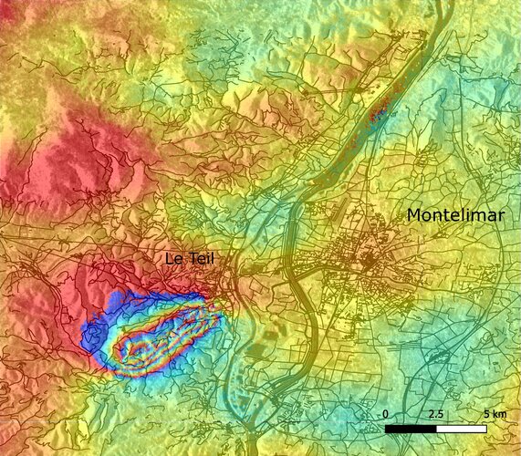
This week, southeast France was hit by a magnitude 5 earthquake with tremors felt between Lyon and Montélimar. The Copernicus Sentinel-1 radar mission has been used to map the way the ground shifted as a result of the quake.
Svaz podnikatelů ve stavebnictví na Žofíně
17.11.2019 6:00 Asociace podnikatelů v geomatice APG obdržela pozvání od technického ředitele SPS Ing. Pavla Ševčíka na setkání s vedením svazu. Na akci se projednávaly aktuální problémy českého stavebnictví a plány nového vedení svazu do budoucna. Za APG se setkání zúčastnil Ing. Jaroslav Kocián, vedoucí pracovní skupiny Inženýrská geodézie.APGEO - SVAZ PODNIKATELŮ VE STAVEBNICTVÍ NA ŽOFÍNĚ
17.11.2019 1:00 Asociace podnikatelů v geomatice APG obdržela pozvání od technického ředitele SPS Ing. Pavla Ševčíka na setkání s vedením svazu.Národní zpráva ČKS
16.11.2019 13:45 Česká kartografická společnost V pravidelném intervalu je vytvářena Zpráva o činnosti České kartografické společnosti, a to pro potřeby Mezinárodní kartografické asociace. Zprávu si můžete přečíst i vy a připomenout si tak, co se v uplynulých čtyřech letech událo…ČÚZK – krátkodobé přerušení provozu DP a WSDP
16.11.2019 10:12 GEPROČÚZK plánuje přerušit provoz Dálkového přístupu (DP) a Webových služeb dálkového přístupu (WSDP) v pátek 22.… >>
Drone delivers laboratory supplies in 43-mile ocean-crossing test for USVI Department of Health
16.11.2019 1:09 GISCafe.com Webcasts-Webinars Silver Spring, MD, Nov. 15, 2019 (GLOBE NEWSWIRE) -- FOR IMMEDIATE RELEASE In a test to improve delivery of health services between communities …From Space to the Seas: Blue Worlds - The European Space Agency (ESA) Initiative Towards Space Projects Support for Sustainable Ocean Activities
15.11.2019 22:34 GISCafe.com Webcasts-Webinars Sustainable Ocean Summit 2019 (Paris, 20-22 Nov)FROM SPACE TO THE SEAS: Blue Worlds – The European Space Agency (ESA) Initiative Towards …
Ověřování podpisů na smlouvách
15.11.2019 20:39 Asociace podnikatelů v geomatice Začátkem října 2019 výkonný ředitel Ing. Jaroslav Cibulka s Ing. Jiřím Habrovcem jednali o možnosti ověřovat podpisy na smlouvách prostřednictvím ÚOZI (Úředně oprávněný zeměměřický inženýr). Tomuto tématu, které by výrazně usnadnilo práci geodetů v terénu, se věnujeme již delší dobu a hledáme možnost, jakým způsobem toto opatření prosadit.Airbus checking ocean satellite Sentinel-6A’s operational fitness
15.11.2019 20:28 GISCafe.com Webcasts-Webinars Test programme is in full swing - Launch scheduled for November 2020Munich, 15 November 2019 – Airbus space engineers are currently testing …
Orbit GT and Getmapping, UK, sign Reseller Agreement
15.11.2019 20:24 GISCafe.com Webcasts-Webinars Lokeren, Belgium, October 8th, 2019Orbit GT is pleased to announce that Getmapping Plc, UK, has joined as Authorized Reseller of Orbit GT 3D …
Velodyne Lidar Debuts Alpha Prime™, the Most Advanced Lidar Sensor on the Market
15.11.2019 19:47 GISCafe.com Webcasts-Webinars Alpha Prime Delivers Unrivaled Combination of Field-of-View, Range, High-Resolution, Clarity and Operational PerformanceSAN JOSE, Calif. — …
Přerušení provozu DP a WSDP v pátek 22.11.2019 od 15:00 až do cca 19:00.
15.11.2019 18:15 Dálkový přístup k údajům KN ČR Vážení uživatelé,oznamujeme, že v pátek 22.11.2019 od 15:00 bude z provozních důvodů zcela přerušen provoz Dálkového přístupu i Webových služeb dálkového přístupu. Obnovení provozu předpokládáme v cca 19:00 hodin.
Omlouváme se za komplikace a děkujeme za pochopení.
Přerušení provozu DP a WSDP v pátek 22.11.2019 od 15:00 až do cca 19:00.
15.11.2019 18:15 ČÚZK - předpisy a opatření Vážení uživatelé,oznamujeme, že v pátek 22.11.2019 od 15:00 bude z provozních důvodů zcela přerušen provoz Dálkového přístupu i Webových služeb dálkového přístupu. Obnovení provozu předpokládáme v cca 19:00 hodin.
Omlouváme se za komplikace a děkujeme za pochopení.
Přerušení provozu DP a WSDP v pátek 22.11.2019 od 15:00 až do cca 19:00.
15.11.2019 18:15 ČÚZK /Aplikace-DP-do-KN/Aplikace-DP-do-KN/Archiv-DP/273492Silent Arrow® 1-Ton Cargo Delivery Drone Secures USSOCOM Development Contract for Flight Testing
15.11.2019 16:31 GISCafe.com Webcasts-Webinars Program scope includes aircraft airworthiness and high-altitude airdrop testing to address U.S. Special Operations Command needs unmet by other …Schůzka pracovní skupiny KN
15.11.2019 16:25 Asociace podnikatelů v geomatice V uplynulém období se uskutečnilo setkání pracovní skupiny Katastr nemovitostí. Členové skupiny definovali především témata, která by se měla projednávat na prosincovém setkání zástupců APG s vedením ČÚZK.Sea-level monitoring satellite on show
15.11.2019 14:00 ESA Observing the Earth
Media representatives and mission partners gathered today in Germany to see a new satellite, which will take the lead in charting sea-level change, before it undergoes final testing and is packed up for shipment to the US for lift-off next year.
PIN: EGNSS-based rail safety service analysis
15.11.2019 10:28 European GNSS Agency
The European Commission’s Directorate-General for Internal Market, Industry, Entrepreneurship and SMEs (DG GROW) has issued a Prior Information Notice (PIN) for a planned call for a new service contract to assess the feasibility of an EGNSS-based safety service for the rail sector beyond 2022 which would make it possible to rationalise rail signalling infrastructure.
When defining the service, the contractor shall produce the service concept and consolidate it through iteration with a Working Group of experts. The analysis will enable the EC to determine whether an EGNOS service needs to be created specifically for rail safety.
The contract notice will be published in the near future. More information can be found in the Prior Information Notice (PIN).
Tailored premiums
Rail signalling systems are used to safely control railway traffic in order to prevent train collisions. There are currently more than 20 rail signalling systems in Europe since each country has developed its own railway infrastructure, equipment and operational rules. This has led to increased costs and technical and operational complexity. Therefore, the European Rail Industry, supported by the EU Institutions, is working on the European Rail Traffic Management System (ERTMS), with an aim to implement a common signalling system for Europe.
Read this: Space4Rail: From innovation to implementation.
The European Commission (EC) is currently specifying the long-term evolution of the EGNSS programme, including new services for Galileo and EGNOS. The use of an EGNSS receiver in combination with other sensors could result in the provision of an accurate and reliable position which would translate into an overall improvement in the rail system.
Galileo is Europe’s Global Navigation Satellite System (GNSS), providing a highly accurate, guaranteed global positioning service under civilian control. Galileo is operational since the Initial Service declaration at the end of 2016. Full Operational Capability is expected to be reached in 2020.
EGNOS is the European SBAS and augments GPS L1 C/A civilian signal by providing corrections and integrity information for positioning and navigation applications over Europe. EGNOS Version 3, set to enter in service in the near future, will augment both GPS and Galileo constellations in the L1 and L5 bands and will extend the service area to the entire landmasse of EU Member States.
Media note: This feature can be republished without charge provided the European GNSS Agency (GSA) is acknowledged as the source at the top or the bottom of the story. You must request permission before you use any of the photographs on the site. If you republish, we would be grateful if you could link back to the GSA website (http://www.gsa.europa.eu).
Program Details Announced for the 2020 GIS/Valuation Technologies Conference
15.11.2019 10:23 GISCafe.com Webcasts-Webinars November 14, 2019 (Des Plaines, IL) -- URISA and the International Association of Assessing Officers (IAAO) are pleased to …Excited and interested visitors @ GSA Open Days 2019
15.11.2019 10:23 European GNSS Agency
The European GNSS Agency (GSA) threw open its doors for the 5th year in a row on 8-9 November to welcome visitors to the GSA Open Days 2019. With a wide range of activities targeted at general public, this year’s event received nearly 2000 visitors from the Czech Republic and across Europe, including families with kids, young adults interested in science and technology, space enthusiasts and young professionals interested in technology and EU affairs.
The GSA Open Days give the public an opportunity to learn about and experience applications based on the EU space programmes Galileo and EGNOS. The theme of this year’s event was Accuracy Matters and the importance of accuracy for a wide range of applications was underlined in a series of seminars, quizzes and workshops in Czech and English held at various times throughout both days.
Landing a plane with EGNOS
Over 350 students from Czech schools and universities registered to attend the event, and this number was augmented by visitors from neighbouring schools who dropped by in the afternoon to take part in the many exciting activities on offer. These included the chance to be a pilot and land an airbus A350 using EGNOS. EGNOS is mainly used in aviation and offers tangible benefits to operators using European skies. By minimising the frequency of aborted landings EGNOS helps in reducing CO2 emissions, delays and noise pollution.
Read this: European Space Week: A taste of what to expect
“End users are at the centre of the European space programme, which was developed with the core aim of benefitting the lives of Europeans. Throwing open the doors of our Prague home to the public gives us at the GSA the opportunity to meet with the beneficiaries of Galileo and EGNOS while giving end users the chance to learn more about the GSA and the benefits of Europe’s investment in space,” GSA Executive Director Carlo des Dorides said.
Galileo to the rescue!
Visitors also had for the first time the opportunity to become initiated in cryptography and decrypt messages, and learn more about Galileo security.It raised a huge interest amongst visitors.
"Search and rescue" feature of Galileo was also in focus, with visitors able to experience a live rescue in the snow-capped Alps with the help of Galileo and be rescued at sea, thanks to Galileo’s added accuracy.
A new addition to this year’s programme focused on the importance of EGNOS in precision agriculture, which is developing at an unprecedented pace with more than 85% of EU farmers now using EGNOS. A farming game gave visitors the chance to test for themselves how EGNOS is optimising tractor use on farms.
And this: MyGalileoApp: the results are in!
With Galileo expected to reach Full Operational Capability in less than 18 months the GSA is growing and, to help meet this demand the GSA’s HR department featured its very own stand at the Open Days to inform visitors about the Agency’s recruitment processes and future openings.
See you next year
In total, GSA staff delivered more than 15 workshops over the 2 days and answered thousands of questions from visitors. Visitors also met with this year’s special guest - Martin Rota, a Czech YouTuber passionate about science and space.
If you were lucky enough to attend this year’s Open Days, then we hope you had an enjoyable visit. If not – then we hope to see you next year, when we will present more success stories from Galileo and EGNOS. In the meantime remember - when close isn’t good enough…#Use Galileo!
Media note: This feature can be republished without charge provided the European GNSS Agency (GSA) is acknowledged as the source at the top or the bottom of the story. You must request permission before you use any of the photographs on the site. If you republish, we would be grateful if you could link back to the GSA website (http://www.gsa.europa.eu).
Excited and interested visitors @ GSA Open Days 2019
15.11.2019 10:23 European GNSS AgencyThe European GNSS Agency (GSA) threw open its doors for the 5th year in a row on 8-9 November to welcome visitors to the GSA Open Days 2019. With a wide range of activities targeted at the general public, this year’s event received nearly 2000 visitors from the Czech Republic and across Europe, including families with kids, young adults interested in science and technology, space enthusiasts and young professionals interested in technology and EU affairs.
The GSA Open Days give the public an opportunity to learn about and experience applications based on the EU space programmes Galileo and EGNOS. The theme of this year’s event was Accuracy Matters and the importance of accuracy for a wide range of applications was underlined in a series of seminars, quizzes and workshops in Czech and English held at various times throughout both days.
Landing a plane with EGNOS
Over 350 students from Czech schools and universities registered to attend the event, and this number was augmented by visitors from neighbouring schools who dropped by in the afternoon to take part in the many exciting activities on offer. These included the chance to be a pilot and land an airbus A350 using EGNOS. EGNOS is mainly used in aviation and offers tangible benefits to operators using European skies. By minimising the frequency of aborted landings EGNOS helps in reducing CO2 emissions, delays and noise pollution.
Read this: European Space Week: A taste of what to expect
“End users are at the centre of the European space programme, which was developed with the core aim of benefitting the lives of Europeans. Throwing open the doors of our Prague home to the public gives us at the GSA the opportunity to meet with the beneficiaries of Galileo and EGNOS while giving end users the chance to learn more about the GSA and the benefits of Europe’s investment in space,” GSA Executive Director Carlo des Dorides said.
Galileo to the rescue!
Visitors also had for the first time the opportunity to become initiated in cryptography, decrypt messages, and learn more about Galileo security. This section raised a lot of interest amongst visitors.
Galileo's Search and Rescue feature was also in focus, with visitors able to experience a live rescue in the snow-capped Alps with the help of Galileo and be rescued at sea, thanks to Galileo’s added accuracy.
A new addition to this year’s programme focused on the importance of EGNOS in precision agriculture, which is developing at an unprecedented pace with more than 85% of EU farmers now using EGNOS. A farming game gave visitors the chance to test for themselves how EGNOS is optimising tractor use on farms.
And this: MyGalileoApp: the results are in!
With Galileo expected to reach Full Operational Capability in less than 18 months the GSA is growing and, to help meet this demand the GSA’s HR department featured its very own stand at the Open Days to inform visitors about the Agency’s recruitment processes and future openings.
See you next year
In total, GSA staff delivered more than 15 workshops over the 2 days and answered thousands of questions from visitors. Visitors also met with this year’s special guest - Martin Rota, a Czech YouTuber passionate about science and space.
If you were lucky enough to attend this year’s Open Days, then we hope you had an enjoyable visit. If not – then we hope to see you next year, when we will present more success stories from Galileo and EGNOS. In the meantime remember - when close isn’t good enough…#Use Galileo!
Media note: This feature can be republished without charge provided the European GNSS Agency (GSA) is acknowledged as the source at the top or the bottom of the story. You must request permission before you use any of the photographs on the site. If you republish, we would be grateful if you could link back to the GSA website (http://www.gsa.europa.eu).
GSA Open Days 2019 gets over 2000 visitors
15.11.2019 10:23 European GNSS AgencyThe European GNSS Agency (GSA) threw open its doors for the 5th year in a row on 8-9 November to welcome visitors to the GSA Open Days 2019. With a wide range of activities targeted at young people and adults, this year’s event received over 2000 visitors from the Czech Republic and across Europe, including families with kids, young adults interested in science and technology, space enthusiasts and young professionals interested in technology and EU affairs.
The GSA Open Days give the public an opportunity to learn about and experience applications based on the EU space programmes Galileo and EGNOS. The theme of this year’s event was Accuracy Matters and the importance of Galileo’s additional accuracy for a wide range of applications was underlined in a series of seminars, quizzes and workshops in Czech and English held at various times throughout both days.
Landing a plane with EGNOS
Over 350 students from Czech schools and universities registered to attend the event, and this number was augmented by visitors from neighbouring schools who dropped by in the afternoon to take part in the many exciting activities on offer. These included the chance to be a pilot and land an airbus A350 using EGNOS. EGNOS is mainly used in aviation and offers tangible benefits to operators using European skies. By minimising the frequency of aborted landings EGNOS helps in reducing CO2 emissions, delays and noise pollution.
Read this: European Space Week: A taste of what to expect
“End users are at the centre of the European space programme, which was developed with the core aim of benefitting the lives of Europeans. Throwing open the doors of our Prague home to the public gives us at the GSA the opportunity to meet with the beneficiaries of Galileo and EGNOS while giving end users the chance to learn more about the GSA and the benefits of Europe’s investment in space,” GSA Executive Director Carlo des Dorides said.
Galileo to the rescue!
Visitors also had the opportunity to build their own satellites, become initiated in cryptography and decrypt messages, and learn more about Galileo security. Search and rescue was also in focus, with visitors able to experience a live rescue in the snow-capped Alps with the help of Galileo and be rescued at sea, thanks to Galileo’s added accuracy.
A new addition to this year’s programme focused on the importance of EGNOS in precision agriculture, which is developing at an unprecedented pace with more than 85% of EU farmers now using EGNOS. A farming game gave visitors the chance to test for themselves how EGNOS is optimising tractor use on farms.
And this: MyGalileoApp: the results are in!
With Galileo expected to reach Full Operational Capability in less than 18 months the GSA is growing and, to help meet this demand the GSA’s HR department featured its very own stand at the Open Days to inform visitors about the Agency’s recruitment processes and future openings.
See you next year
In total, GSA staff delivered more than 15 workshops over the 2 days and answered thousands of questions from visitors. Visitors also met with this year’s special guest - Martin Rota, a Czech YouTuber passionate about science and space.
If you were lucky enough to attend this year’s Open Days, then we hope you had an enjoyable visit. If not – then we hope to see you next year, when we will present more success stories from Galileo and EGNOS. In the meantime remember - when close isn’t good enough…#Use Galileo!
Media note: This feature can be republished without charge provided the European GNSS Agency (GSA) is acknowledged as the source at the top or the bottom of the story. You must request permission before you use any of the photographs on the site. If you republish, we would be grateful if you could link back to the GSA website (http://www.gsa.europa.eu).
Earth from Space: Lake Tai
15.11.2019 10:00 ESA Observing the Earth Video:
00:02:45
Video:
00:02:45
In this week's edition of the Earth from Space programme, the Copernicus Sentinel-2 mission takes us over the third largest freshwater lake in China.
See also Lake Tai, China to download the image.
Earth from Space: Lake Tai
15.11.2019 10:00 ESA Observing the Earth
Video:
00:02:45
In this week's edition of the Earth from Space programme, the Copernicus Sentinel-2 mission takes usoverthe third largest freshwater lake in China.
See also Lake Tai, China to download the image.
Lake Tai, China
15.11.2019 10:00 ESA Observing the Earth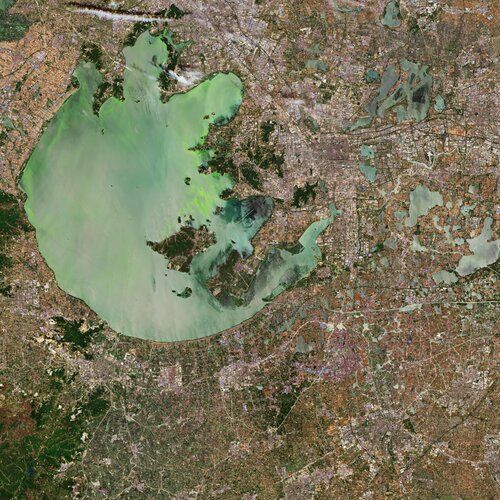 Image:
The Copernicus Sentinel-2 mission takes us over the Lake Tai, the third largest freshwater lake in China. The lake, also known as Lake Taihu, is located in the Jiangsu province and is approximately 70 km long and 60 km wide, with an average water depth of approximately 2 metres. The lake discharges its waters through Wusong, Liu, Huangpu and several other rivers.
The Tai Basin is a very developed region in China, and includes the megacities Suzhou, visible east of the lake, Wuxi, visible north of the lake, and the nearby Shanghai. Over the past decades, rapid urbanisation, population growth and excessive fish farming have resulted in eutrophication – where the lake becomes enriched with minerals and nutrients.
The increase of nutrients deteriorate the water quality of the lake causing toxic algae blooms to form on the lake’s surface – threatening the quality for millions of people who depend on the lake as a source of drinking water.
In 2007, the algal blooms were so severe that the outbreak was declared a health emergency. Water supplies to Wuxi were suspended, leaving two million residents without drinking water for several weeks.
In this image captured on 24 May 2019, the algae-infested waters are clearly visible.
Algae blooms have been reported in the lake since the 1980s. Many attempts have been made to salvage the water quality of the lake including removal of the algae, closing chemical and manufacturing plants near Tai and stricter water treatment regulations.
However, the lake remains to be highly polluted. Agriculture, sewage and manufacturing still affect the lake’s waters – overloading it with nutrients.
Sentinel-2 is a two-satellite mission to supply the coverage and data delivery needed for Europe’s Copernicus programme. The mission’s frequent revisits over the same area and high spatial resolution allow changes in inland water bodies to be closely monitored.
This image is also featured on the Earth from Space video programme.
Leica Geosystems enables a new era for GIS data capture
15.11.2019 9:57 GISCafe.com Webcasts-Webinars Leica Zeno Mobile integrates HxGN SmartNet post-processing service, Esri’s Geospatial Cloud(Heerbrugg, Switzerland, 14 November 2019) …
Sanjay Gangal interviews Kevin Jones, Executive Director of Marketing from PCI Geomatics at UAV CONFERENCE
15.11.2019 9:00 GISCafe.com Webcasts-WebinarsSchneider Electric Provides Grid Flexibility With The Release Of Ecostruxure™ Derms
15.11.2019 9:00 GISCafe.com Webcasts-Webinars Supporting the growing adoption of Distributed Energy ResourcesParis, France, November 12, 2019 – Schneider Electric, global specialist …
Bentley Systems Brings City-Scale and Campus Digital Twins to Smart City Expo World Congress
15.11.2019 1:00 Bentley Systems Bentley Systems invites you to meet with company executives to learn about city-scale digital twins at Smart City Expo World Congress. With a digital twin, municipalities can create, visualize, and analyze a city-wide digital twin of its infrastructure. City stakeholders gain new insights by modeling and simulating real-world situations, optimizing systems and processes, and monitoring the performance and condition of assets. Using examples from innovative and award-winning infrastructure projects around the world, Bentley executives will provide insights into how these organizations are leveraging digital context, components, and chronology to embrace a data-driven approach for city and campus infrastructure from planning through performance. In addition, Bentley will also discuss its recently announced OpenGround, a new cloud service (available end of 2019) to store, manage, report, and share data about natural ground conditions.Smart City Expo World Congress
19-21 November 2019
Fira Barcelona Grand Via
Av. Joan Carles I, 64, 08908 L'Hospitalet de Llobregat
Barcelona, Spain
Booth location: Gran Via, Hall 2, Level 0, Street B, Stand 223 (within the Microsoft booth)
Bentley Systems representatives will be on site to discuss digital twins and digital twin workflows for infrastructure to support smart city use initiatives:
Jerry King – Vice President, Strategic Channel
Phil Christensen – Senior Vice President, Business Development, Digital Cities
Ton De Vries – Senior Director, Business Development, Digital Cities
Hakan Engman – Director, Business Development, Digital Cities
Frank Braunschweig – Senior Product Manager, Water and Wastewater
For information or to schedule interviews
Contact Santiago Romero, Regional Marketing Manager Southern EU and Nordics: santiago.romero@bentley.com
Advancing BIM and GIS to 4D with Digital Twins
At its annual Year in Infrastructure 2019 event, Bentley Systems presented its new digital cities initiatives, applying digital twins for more efficient city and regional operations and for more connected and resilient infrastructure. Digital twins converge assets’ 4D-surveyed and engineering representations to enable new collaborative digital workflows serving planners and engineers in public works, utilities, property management and development, and city stakeholders. Digital twin cloud services provide an intuitive and immersive 4D environment converging digital context and digital components with digital chronology for “evergreen” infrastructure digital twins over asset lifecycles. For infrastructure professionals, BIM and GIS are effectively advanced through 4D digital twins.
Infrastructure Digital Twins for Digital Cities
City-scale digital twins begin and are updated through 4D surveying and reality modeling by ContextCapture and Orbit GT to derive as-operated 3D models from photogrammetry (including from UAVs) and/or point clouds. Reality modeling provides engineering-precise, real-world context to support planning, design, construction, and operations. Users of Bentley’s open applications (OpenCities, OpenBuildings, OpenSite, OpenRoads, OpenRail, OpenUtilities) can leverage this digital context to model new and improved buildings, roads, transit systems, tunnels, bridges, utilities, and more.
City Planning Digital Twins
Digital twins for cities have many stakeholders, including constituents not directly involved in engineering or infrastructure. Now hosted in multiple Microsoft Azure regions, OpenCities Planner delivers cloud-based, city-scale digital twins to improve stakeholder and citizen engagement and to simplify and facilitate urban development. Addressing a wide variety of potential use cases, OpenCities Planner helps users, through devices like web, mobile, touchscreens, and digital billboards, to intuitively visualize and explore 2D, 3D, GIS and other data aligned with the reality model of the city.
Geotechnical Digital Twins: Introducing OpenGround
Bentley’s geotechnical engineering and analysis applications empower subsurface digital twins, critical for assessing and managing risks in infrastructure projects and assets. Subsurface digital twins entail modeling of the underground environment, including the geology, hydrology, chemistry, and engineering properties, made possible by Bentley’s geotechnical offerings (PLAXIS, SoilVision, Keynetix and gINT). To further enable subsurface digital twins, Bentley introduces OpenGround, a new cloud service (available end of 2019) to store, manage, report, and share data about natural ground conditions.
Sustainability and Resilience Digital Twins
Now, cities can combine their surface and subsurface surveys and engineering data into cohesive 4D digital twins to ensure over time their asset performance, resiliency, and sustainability. Using Bentley’s open simulation applications during asset lifecycles, for example, as-constructed buildings can be evaluated for seismic resilience (STAAD), the evacuation of vehicles and people in stations, stadiums, and other public places can be assessed and optimized (LEGION and CUBE), the impact of flooding events like hurricanes can be determined (OpenFlows FLOOD), and the suitability of subsurface conditions for urban projects can be ensured (PLAXIS, SoilVision).
Press Releases
Bentley Systems Accelerates Focus on Infrastructure Engineering for Digital Cities
Bentley Systems Bolsters Digital Cities Offerings with Acquisitions of Citilabs and Orbit Geospatial Technologies
Bentley Systems Announces New iTwin Cloud Services for Infrastructure Engineering Digital Twins
Advancement Insights
Cities Leverage Digital Twin Initiatives to Advance BIM and GIS Improving the Quality of Life for Their Constituents
Digital Twins in Utilities – articles and video
Building Smarter Cities with Digital Twins
Seven ways cities benefit from digital twins
Digital Cities overview video
About Bentley Systems
Bentley Systems is the leading global provider of software solutions to engineers, architects, geospatial professionals, constructors, and owner-operators for the design, construction, and operations of infrastructure, including public works, utilities, industrial plants, and digital cities. Bentley’s MicroStation-based open modeling applications, and its open simulation applications, accelerate design integration; its ProjectWise and SYNCHRO offerings accelerate project delivery; and its AssetWise offerings accelerate asset and network performance. Spanning infrastructure engineering, Bentley’s iTwin Services are fundamentally advancing BIM and GIS to 4D digital twins.
In both 2018 and 2019, Microsoft named Bentley Systems as Partner of the Year in its CityNext category. In 2019, ARC Advisory Group’s Engineering Design Tools for Plants, Infrastructure, and BIM market study ranked Bentley #1 in Water and Wastewater Distribution.
Bentley Systems employs more than 3,500 colleagues, generates annual revenues of $700 million in 170 countries, and has invested more than $1 billion in research, development, and acquisitions since 2014. From inception in 1984, the company has remained majority-owned by its five founding Bentley brothers. www.bentley.com
Topografická databáze České republiky (Data200) - všechny vrstvy
15.11.2019 1:00 Cenia - Katalog metadat ČR - INSPIRE Topografická databáze České republiky (Data200) - všechny vrstvy. Minimální polohová přesnost je 100 m a podrobnost odpovídá měřítku 1:200 000. Obsah Data200 tvoří 50 typů geografických objektů. Databáze je strukturovaná do osmi tematických skupin - administrativní hranice, vodstvo, doprava, sídla, geografická jména, různé objekty, vegetace a povrch, výškopis. Vrstva výškopisu byla v roce 2013 doplněna o stínovaný terén.Digitální geografický model území ČR (Data50) - všechny vrstvy
15.11.2019 1:00 Cenia - Katalog metadat ČR - INSPIRE Data50 je digitální geografický model území České republiky (ČR) odvozený z kartografické databáze pro Základní mapu ČR 1 : 50 000. Data jsou poskytována jako otevřená data ve formátu SHP a celkem se skládají z 8 tematických oblastí- Sídelní, kulturní a hospodářské objekty, Komunikace, Produktovody a elektrické vedení, Vodstvo, Hranice územních jednotek, Vegetace a povrch, Terénní reliéf a Popis.APGEO - SCHŮZKA PRACOVNÍ SKUPINY KN
15.11.2019 1:00 Asociace podnikatelů v geomatice V uplynulém období se uskutečnilo setkání pracovní skupiny Katastr nemovitostí. Členové skupiny definovali především ...APGEO - OVĚŘOVÁNÍ PODPISŮ NA SMLOUVÁCH
15.11.2019 1:00 Asociace podnikatelů v geomatice Začátkem října 2019 výkonný ředitel Ing. Jaroslav Cibulka s Ing. Jiřím Habrovcem jednali o možnosti ověřovat podpisy ...NIAS launches World’s Premier B2B Trade and Investment Matchmaking Platform for Commercialization of Autonomous Systems: Nevada-Global Drone Trade Alliance
15.11.2019 0:08 GISCafe.com Webcasts-Webinars 12 November 2019. Following an immensely successful week at the Commercial UAV Expo in Las Vegas 28-30 October 2019, the Nevada …
Ouster Introduces Low-Cost, High-Resolution 32-Channel Lidar Sensor
14.11.2019 22:27 GISCafe.com Webcasts-Webinars OS1-32 boasts improved resolution at attainable priceShipping now for $8,000 with volume and education discounts available
Integrates new …
The potential for Earth observation to reduce risk in the Oil and Gas industry
14.11.2019 19:34 GISCafe.com Webcasts-Webinars The volume and variety of data gathered from Earth Observation (EO) satellites in orbit today has been increasing at a rapid pace; in 2019, the …UvA and TomTom to Open New Research Lab for Autonomous Driving
14.11.2019 19:33 GISCafe.com Webcasts-Webinars AMSTERDAM, the Netherlands, Nov. 14, 2019 (GLOBE NEWSWIRE) -- Location technology specialist, TomTom (TOM2), and the University of Amsterdam (UvA), …Esri Joins Autodesk University 2019 Conference
14.11.2019 19:32 GISCafe.com Webcasts-Webinars GIS Experts Will Demonstrate How Location Intelligence Enables Smart Design and PlanningREDLANDS, Calif. — (BUSINESS WIRE) — November …
Texas A&M University to Establish Trimble Technology Lab for Geosciences
14.11.2019 19:32 GISCafe.com Webcasts-Webinars SUNNYVALE, Calif. and COLLEGE STATION, Texas, Nov. 14, 2019 — (PRNewswire) — Texas A&M University has received a gift from …Drone Aviation Announces Record Revenue and Profitability in Third Quarter 2019
14.11.2019 19:32 GISCafe.com Webcasts-Webinars Company Achieves Improved Sequential Quarterly Results Driven by Additional Product Sales and Services Revenue in Support of United States Border …ɸ-Sat-2 challenge
14.11.2019 16:22 ESA Observing the Earth
ɸ-Sat-2 challenge
Submit your idea for the AI ɸ-Sat-2 mission. Deadline 15 January 2020.
ɸ-Sat-2 challenge
14.11.2019 16:22 ESA Observing the Earth
ɸ-Sat-2 challenge
Submit your idea for the AI ɸ-Sat-2 mission. Deadline 15 January 2020.
Výstava 3D modelů [Katedra aplikované geoinformatiky a kartografie, byTopic]
14.11.2019 14:20 Katedra aplikované geoinformatiky a kartografie Přf UK Srdečně vás zveme na Výstavu 3D modelů, která probíhá od 11. listopadu do 29. února v předsálí Mapové sbírky na Albertově 6, Praha 2. Výstava prezentuje výsledky tvorby 3D modelů, které vznikly ve spolupráci vědeckých pracovníků a studentů na katedře aplikované geoinformatiky a kartografie PřF UK. Vstup volný.36. OGiC – Esri není black box s Ing. Petrem Seidlem, CSc. a Mgr. Ondřejem Sadílkem
14.11.2019 11:34 Katedra geoinformatiky UP OlomoucZnáte ArcGIS? 🌎 A umíte si představit, co se za ním skrývá? 🤓 Přijďte se dozvědět, co všechno ve světe GIS znamená Esri a čím se zabývá Arcdata Praha, s.r.o. 😊 27. listopadu od 10:00 na učebně S3 vám nejen o tom povykládá samotný řiditel této společnosti Ing. Petr Seidl, CSc. spolu s našim absolventem Mgr. Ondřejem Sadílkem 👌
The post 36. OGiC – Esri není black box s Ing. Petrem Seidlem, CSc. a Mgr. Ondřejem Sadílkem appeared first on Katedra geoinformatiky.
Plex.Earth Timeviews™ empowers AEC professionals with the latest satellite imagery within AutoCAD
14.11.2019 11:19 GISCafe.com Webcasts-Webinars November 14, 2019 -- Plexscape, developers of Plex.Earth®, one of the most popular tools for AutoCAD for the acceleration of …GNSS and the future of rail
14.11.2019 10:37 European GNSS Agency
New technologies that offer safety and efficiency benefits will define the rail system of the future. GNSS is one such technology and is already being used to track rolling-stock, and in passenger information, traffic management and predictive maintenance systems. In his speech at the ERTMS conference #CCRCC2019 “The Engine for the Digital Future,” European GNSS Agency (GSA) Executive Director Carlo des Dorides outlined how his Agency is working with the rail sector.
Over the last few years, the GSA has been working with its partners in the rail and space domains to introduce GNSS into non-safety relevant applications in the rail sector. This work has paid off, and currently more than 30 000 wagons of German rail freight company DB Cargo are equipped with Galileo-enabled telematics devices. Furthermore, 250 TGV trains in France are already using Galileo-enabled receivers and the rollout of these receivers on non-high speed trains is also in the pipeline.
A game changer
In his address at a conference, organised by the European Union Agency for Railways (ERA) in Valenciennes on October 15-17, the GSA Executive Director noted, however, that when it comes to the use of GNSS in signalling, progress had been slower. “We are simply not there yet and our main objective - to include European GNSS in the evolution of the ERTMS - is still being discussed,” he said.
To this end, the GSA defined a joint roadmap together with UNIFE, CER, Shift2Rail, the ERTMS Users Group and the European Space Agency (ESA) and, in 2016, GNSS entered the rail innovation landscape as an ERTMS game changer in a Memorandum of Understanding signed in 2016 to formalise an integrated management process for ERTMS deployment in Europe.
Read this: French railways embrace Galileo
Then, in 2017, together with ERA and International Union of Railways (UIC) the GSA participated in the first demonstration of an E-GNSS based virtual balise concept on board a running train on a pilot line in Sardinia, where work is continuing towards possible certification.
“We have also supported the EU railway industry in conducting a large-scale test campaign to define the achievable GNSS performance in the complex railway environment. Our partners in Shift2Rail are using these results to define the suitable architectures for GNSS inclusion in the ERTMS, hopefully within the next release planned for 2023,” des Dorides said.
Exporting innovation
GNSS is already being used in train positioning for safety relevant applications in the United States and a European manufacturer of GNSS chipsets has been selected to equip more than 30 000 miles of track with an augmentation system, improving GNSS performance in terms of accuracy and integrity. “Their receivers, which are Galileo enabled, will also be mounted on all new freight locomotives of the WABTEC Corporation. This is a clear success for a European company, benefitting from innovation and proving the European capacity to drive innovation,” des Dorides said.
Watch this: EGNOS and Galileo for Rail
Noting that GNSS is already supporting safety-relevant and liability-critical applications in other segments, such as aviation and road, des Dorides noted that in rail too, it was time to progress to the demonstration and certification of the technology “to make sure that Europe does not miss the train.”
“The GSA is committed to providing further support to rail stakeholders in this regard. We are ready to tailor our services, such as in case of EGNOS, based on the operational needs and requirements of railways, with properly defined interoperable interfaces,” he said, adding that this was an important element, as the introduction of GNSS into the ERTMS is not about creating space for any vendor-specific or national solutions.
“What we need is continuation of the commitment and collaboration from rail operators, infrastructure managers and the EU railway industry working with us to overcome the ‘last mile’ towards inclusion of interoperable GNSS-based positioning within the next evolutions of the ERTMS,” he said.
Media note: This feature can be republished without charge provided the European GNSS Agency (GSA) is acknowledged as the source at the top or the bottom of the story. You must request permission before you use any of the photographs on the site. If you republish, we would be grateful if you could link back to the GSA website (http://www.gsa.europa.eu).
Pozvánka na přednášku Ing. Petra Seidla, CSc. z firmy ARCDATA PRAHA, s.r.o.
14.11.2019 10:16 Blogující geomatici - FAV ZČU Dovolujeme si vás pozvat na přednášku Ing. Petra Seidla, CSc. ze společnosti ARCDATA PRAHA, s.r.o., který bude dne 25. 11. ve 13:00 v UC 233 hovořit o užitečnosti geografických informačních systémů pro společnost a o jejich různorodých způsobu nasazení a využití.Map of the Month: GfK Purchasing Power Europe 2019
14.11.2019 10:15 GISCafe.com Webcasts-Webinars GfK's Map of the Month for November shows the distribution of purchasing power in Europe in 2019.Bruchsal, 13.11.2019 -- According to …
Enterprise Partnerships with Trimble and Microsoft Drive senseFly Strategy Forward
14.11.2019 10:04 GISCafe.com Webcasts-Webinars CHESEAUX-SUR-LAUSANNE, Switzerland, 13 November 2019 – senseFly, the global leader in fixed-wing drones, has announced new strategic …Sanjay Gangal interviews Todd Stave, CEO from Blue Vigil at UAV CONFERENCE
14.11.2019 9:00 GISCafe.com Webcasts-WebinarsDJI Demonstrates Direct Drone-To-Phone Remote Identification
14.11.2019 1:45 GISCafe.com Webcasts-Webinars Simple, Low-Cost Solution Meets Government Expectations To Identify Airborne DronesMONTREAL, Nov. 13, 2019 — (PRNewswire) — DJI, the …
Území s dominantním výskytem tetřeva hlušce - fragmentační studie
14.11.2019 1:00 Cenia - Katalog metadat ČR - INSPIRE Polygonová vrstva území, které je dle studie fragmentační studie (zpracované Českou ornitologickou společností) územím, kde lze očekávat dominantní výskyt tetřeva hlušce (s určitými stanovenými hladinami pravděpodobnosti).Pravděpodobnosti výskytu - kateogie - nad 33,4%, nad 40%, nad 50%, nad 60% a nad 70%.Imise - pětileté průměry v síti 1 x 1 km
14.11.2019 1:00 Cenia - Katalog metadat ČR - INSPIRE Služba obsahuje pětileté průměry imisních koncentrací vybraných polutantů (PM10, PM2.5, NO2, benzen, arsen, Benzo(a)pyren, SO2, olovo, nikl, kadmium) v síti 1x1 km pro období 2014 - 2018, 2013 - 2017. Zdroj dat: Český hydrometeorologický ústav.Ortofotomapa NP a CHKO Šumava - 2019
14.11.2019 1:00 Cenia - Katalog metadat ČR - INSPIRE Ortofotomapa v přirozených barvách (R,G,B) i ortofomapa CIR.Pořizována v kladu mapových listů Státní mapy 1 : 5 000 (2 x 2,5 km).Pixel: 20 cmCarlson Introduces the New VS+ Stope Surveying System
13.11.2019 21:48 Carlson Software MAYSVILLE, Kentucky, U.S.A. (November 2019) — Carlson Software has just released its new Void Scanner+ (VS+), a fully wireless surveying system designed to be used for underground surveying. The system is an upgraded model of Carlson’s standard Void Scanner. Engineered to scan in extreme environments, the ruggedized VS+ system is designed to be deployed into […]Orbit GT and MaxOn Map, Brazil, sign Reseller Agreement
13.11.2019 20:26 GISCafe.com Webcasts-Webinars Lokeren, Belgium, November 8th, 2019 Orbit GT is pleased to announce that MaxOn Map Ltda, Brazil, has joined as Authorized Reseller of Orbit GT 3D …USGIF Accepting Applications for Annual Scholarship Program
13.11.2019 20:24 GISCafe.com Webcasts-Webinars Foundation offers a variety of scholarship opportunities for college studentsHerndon, Virginia (November 13, 2019)—The United States …
LeddarTech is Recognized as a CES 2020 Innovation Award Honoree for The Leddar Pixell, a Cocoon LiDAR Recently Released for the Autonomous Vehicle Market
13.11.2019 19:09 GISCafe.com Webcasts-Webinars QUEBEC CITY, Nov. 13, 2019 (GLOBE NEWSWIRE) -- LeddarTech®, an industry leader in LiDAR technology providing the most versatile and scalable …Velodyne Expert Addresses Lidar Use Cases to Improve Security and Safety Performance
13.11.2019 19:09 GISCafe.com Webcasts-Webinars Session Examines How Lidar Enables Smart Security and Automated Monitoring SystemsSAN JOSE, Calif. — (BUSINESS WIRE) — November 13, 2019 …
XAG Wins Top Honour the 'Best Innovation in Precision Farming Technology' at Crop Science Awards 2019
13.11.2019 19:09 GISCafe.com Webcasts-Webinars LONDON, Nov. 13, 2019 — (PRNewswire) — XAG has been awarded Best Innovation in Precision Farming Technology for its smart agriculture …ManTech Wins $82 Million NSWC Crane Award for Technical Innovation in Next Generation Unmanned ISR Aircraft
13.11.2019 19:09 GISCafe.com Webcasts-Webinars HERNDON, Va., Nov. 13, 2019 (GLOBE NEWSWIRE) -- ManTech (Nasdaq: MANT) announced today that it has been awarded a five-year $82 million prime task …DroneDeploy announces $35M Series D led by Bessemer Venture Partners
13.11.2019 19:09 GISCafe.com Webcasts-Webinars Tracy Young, founder of PlanGrid, joins Board to help bring DroneDeploy to every job siteSAN FRANCISCO, Nov. 13, 2019 — (PRNewswire) — …
Bushfires rage in Australia
13.11.2019 15:30 ESA Observing the Earth Image:
The Copernicus Sentinel-3 mission captured the multiple bushfires burning across Australia’s east coast. Around 150 fires are still burning in New South Wales and Queensland, with hot and dry conditions accompanied with strong winds, said to be spreading the fires.
In this image, captured on 12 November 2019 at 23:15 UTC (13 November 09:15 local time), the fires burning near the coast are visible. Plumes of smoke can be seen drifting east over the Tasman Sea. Hazardous air quality owing to the smoke haze has reached the cities of Sydney and Brisbane and is affecting residents, the Australian Environmental Department has warned.
Hundreds of homes have been damaged or destroyed, and many residents evacuated. Flame retardant was dropped in some of Sydney’s suburbs as bushfires approached the city centre. Firefighters continue to keep the blazes under control.
The Copernicus Emergency Mapping Service was activated to help respond to the fires. The service uses satellite observations to help civil protection authorities and, in cases of disaster, the international humanitarian community, respond to emergencies.
Quantifying and monitoring fires is fundamental for the ongoing study of climate, as they have a significant impact on global atmospheric emissions. Data from the Copernicus Sentinel-3 World Fire Atlas shows that there were almost five times as many wildfires in August 2019 compared to August 2018.
Bushfires rage in Australia
13.11.2019 15:30 ESA Observing the Earth
Image:
The Copernicus Sentinel-3 mission captured the multiple bushfires burning across Australia’s east coast. Around 150 fires are still burning in New South Wales and Queensland, with hot and dry conditions accompanied with strong winds, said to be spreading the fires.
In this image captured on 12 November 2019 at 23:15 UTC (13 November 09:15 local time), the fires burning near the coast are visible. Plumes of smoke can be seen drifting east over the Tasman Sea. Hazardous air quality owing to the smoke haze has reached the cities of Sydney and Brisbane and is affecting residents, the Australian Environmental Department has warned.
Hundreds of homes have been damaged or destroyed, and many residents evacuated. Flame retardant was dropped in some of Sydney’s suburbs as bushfires approached the city centre. Firefighters continue to keep the blazes under control.
The Copernicus Emergency Mapping Service was activated to help respond to the fires. The service uses satellite observations to help civil protection authorities and, in cases of disaster, the international humanitarian community, respond to emergencies.
Quantifying and monitoring fires is fundamental for the ongoing study of climate, as they have a significant impact on global atmospheric emissions. Data from the Copernicus Sentinel-3 World Fire Atlas shows that there were almost five times as many wildfires in August 2019 compared to August 2018.
Výstava "Joachim Barrande: To jest to, co jsem viděl" v Knihovně geologie [Knihovna geografie, byTopic]
13.11.2019 12:25 Katedra aplikované geoinformatiky a kartografie Přf UKEuropean Space Week: A taste of what to expect
13.11.2019 11:14 European GNSS Agency
It’s that time of year again. Preparations are already well underway for European Space Week 2019, which this year will take place at the Helsinki Congress Paasitorni in the Finnish capital on December 3-5. The week will be packed full of exciting events ranging from keynotes, discussions and conference sessions, to the E-GNSS User Assembly, a festive awards ceremony and much more.
As in previous years, European Space Week will address space-related topics targeted at various audiences, from policy-makers and start-ups to public authorities and industry players. With its mix of panel discussions, networking opportunities, business matchmaking sessions and exhibitions, EUSW is an ideal forum for a productive exchange of ideas and discussion of current challenges and future trends in the space sector.
This year’s European Space Week will focus on a number of central themes around sustainability. Participants will investigate how space solutions can help to strengthen the EU’s position as a global leader in climate action. Other themes include the new space economy for sustainable growth; the sustainable space economy - saving space for future generations; and space solutions for a sustainable Arctic. For a full programme of the week’s events, click here.
Read this: Galileo and EGNOS featured at InterGEO 2019
As always, European GNSS (Galileo and EGNOS) will be at the heart of events during Space Week, with an E-GNSS Service Provision Workshop, the E-GNSS User Assembly and a session at which Investors meet Innovators.
E-GNSS in focus
By bringing together stakeholders from across the space ecosystem, European Space Week is an ideal forum to host the E-GNSS User Assembly, which gathers users of position, navigation and time solutions and the organizations involved in the management, service provision and security of Galileo and EGNOS.
At the User Assembly, the European GNSS Agency (GSA) will present an update on GNSS user needs and requirements along with the results of its User Satisfaction Survey. It will also present highlights from the latest GNSS Market Report 2019.
Moreover, keynote speakers representing each market segment and receiver manufacturers will be invited to share the latest trends and applications on consumer solutions, road, aviation, drones, maritime, emergency response, rail, agriculture, geomatics, critical infrastructure and spacecraft.
The E-GNSS Service Provision Workshop will bring together E-GNSS stakeholders, professional and commercial users and application developers to discuss the current status of the EU satellite navigation programmes, and their vision for a stronger EU presence in the satnav applications landscape. There will also be a discussion on the future of EGNSS and the second generation of the Galileo programme. The aim of this session is to ensure that Galileo and EGNOS continue to deliver high quality services, accessible to all in the most cost-efficient manner, and responding to current and future user needs.
And this: Europe’s economy is increasingly dependent on space - ITRE committee hears
Power of synergy
To fully leverage the benefits of the EU space programmes EGNOS, Galileo and Copernicus we need to take a comprehensive look at these programmes. This allows us to see that there are market segments and applications that profit from synergies between E-GNSS and Copernicus and even the GOVSATCOM programme.
The Investors meet Innovators session will give innovators the chance to learn about various private funding opportunities and best practises on how to access funding and sustain their business. At the session, they will be able to engage in intensive discussions with financial partners from various backgrounds such as business angels, venture capitalists, public investment funds, crowd-funding and acceleration programmes.
EUSW will also host an SME Fair, showcasing SMEs developing Galileo, EGNOS or Copernicus-based applications, products and services.
Don’t miss out
Register here to attend European Space Week - Europe’s no. 1 space event. Don’t miss this exciting opportunity to discover cutting-edge Galileo and Copernicus applications and meet award-winning entrepreneurs, start-ups and visionaries. During the week, you will also have the opportunity to expand your network and interact with the Earth observation and satellite navigation community and discuss the latest trends with decision-makers, innovators and industry leaders.
Media note: This feature can be republished without charge provided the European GNSS Agency (GSA) is acknowledged as the source at the top or the bottom of the story. You must request permission before you use any of the photographs on the site. If you republish, we would be grateful if you could link back to the GSA website (http://www.gsa.europa.eu).
20191113 - VŘ ředitel KP Mělník
13.11.2019 9:44 ČÚZK - předpisy a opatření Český úřad zeměměřický a katastrální zveřejnil novou aktualitu: Oznámení o vyhlášení výběrového řízení na obsazení služebního místa ředitele katastrálního pracoviště Mělník.20191113 - VŘ ředitel KP Mělník
13.11.2019 9:44 ČÚZK /Aktuality-resort/2019/20191113-VR-reditel-KP-MelnikOpenGeoLabs nabízí technickou podporu open source softwaru
13.11.2019 9:28 GeoBusiness Firma OpenGeoLabs spouští program technické podpory otevřeného GIS software jako je QGIS, GRASS GIS, GeoServer, PostGIS a Python pro prostorová data. Podpora zahrnuje běžnou ... PřečístOpenGeoLabs nabízí technickou podporu open source softwaru
13.11.2019 9:28 GeoBusiness Firma OpenGeoLabs spouští program technické podpory otevřeného GIS software jako je QGIS, GRASS GIS, GeoServer, PostGIS a Python pro prostorová data. Podpora zahrnuje běžnou uživatelskou podporu, doporučení pracovních postupů (import dat, nastavení, problémy se spuštěním…), monitoring nových verzí a doporučení aktualizace softwaru, migraci procesů a dat z jiných prostředí do otevřeného software (podle rozsahu a […]Spationomy – OpenAccess Springer kniha ke stažení
13.11.2019 9:03 GISportal.cz
V prestižním vydavatelství Springer právě vyšla kniha s názvem Spationomy (Spatial Exploration of Economic Data and Methods of Interdisciplinary Analytics), na jejímž vzniku se podíleli olomoučtí geoinformatici. Kniha je završením úspěšné spolupráce v rámci mezinárodního projektu Spationomy a její .pdf verze je veřejnosti dostupná v režimu open-access na webových stránkách vydavatelství.
The post Spationomy – OpenAccess Springer kniha ke stažení appeared first on GISportal.cz.
Sanjay Gangal interviews Robert Blank, Director of Strategy from SolSpec, Inc at UAV CONFERENCE
13.11.2019 9:00 GISCafe.com Webcasts-WebinarsCubeWerx releases new tools for geospatial analytics
13.11.2019 9:00 GISCafe.com Webcasts-Webinars Gatineau, QC, Canada, November 14, 2019 – CubeWerx, a leader in providing advanced geospatial web services for data providers announced the …GeoSocial Networking Forum 2019
13.11.2019 2:17 Satlab GeosolutionsIt has been quite a year of development, and we have been innovating our solutions for professionals in the geospatial industry. We would like to take this opportunity to invite you to be the first in the region to learn about our newly developed applications for smart industries solution: Indoor Positioning Intelligence, Machine Control and […]
The post GeoSocial Networking Forum 2019 appeared first on Satlab – Global Satellite Positioning Solutions.
GeoSocial Networking Forum 2019
13.11.2019 2:17 Satlab GeosolutionsIt has been quite a year of development, and we have been innovating our solutions for professionals in the geospatial industry. We would like to take this opportunity to invite you to be the first in the region to learn about our newly developed applications for smart industries solution: Indoor Positioning Intelligence, Machine Control and […]
The post GeoSocial Networking Forum 2019 appeared first on SatLab – Global Satellite Positioning Solutions.
Výzva k podání návrhu - Spytihněv
13.11.2019 0:00 Státní pozemkový úřad SPÚ vyhlašuje výzvu k podání návrhů na uzavření nájemní smlouvy - kú Spytihněv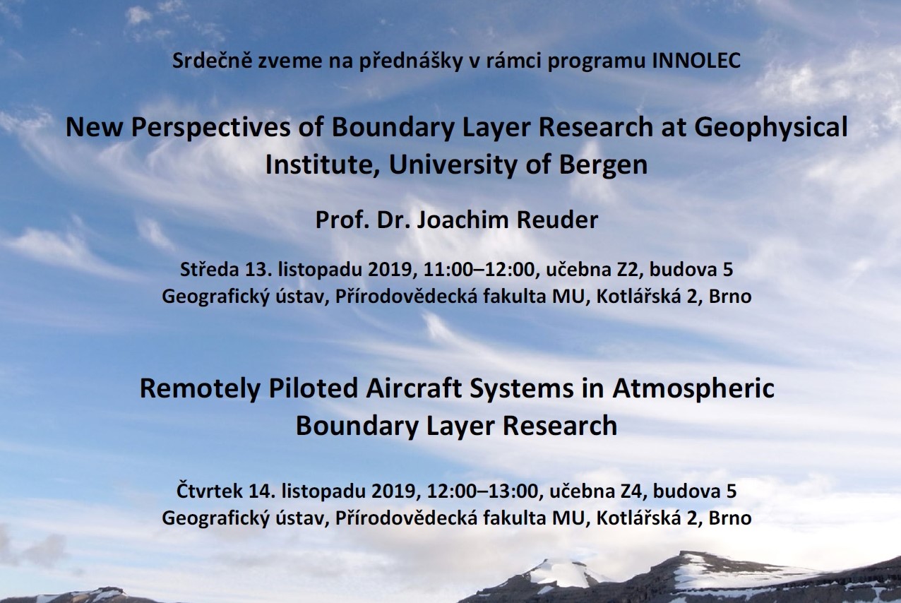
OGC Renews Memorandum Of Understanding With FrontierSI
12.11.2019 21:24 GISCafe.com Webcasts-Webinars OGC and FrontierSI continue to work together to reach out, innovate, and educate at national, regional, and international levels.The Open …
Letní školy katedry geoinformatiky
12.11.2019 19:27 Katedra geoinformatiky UP OlomoucOpět po roce vám katedra přináší možnost přihlásit se na některou z letních škol 🧐 Je libo podívat se do Mariboru, Ultrechtu, Trondheimu, nebo radši preferujete krásy Olomouce? 🙂 Není problém, vybere si každý 😉 Přijďte se informovat o podrobnostech 21. 11. 2019 o 12:45 na učebnu S3 ‼️
The post Letní školy katedry geoinformatiky appeared first on Katedra geoinformatiky.
Nokia joins Sendai City in world’s first test of private wireless connected drones for tsunami evacuation alerts
12.11.2019 18:59 GISCafe.com Webcasts-Webinars Press Release Nokia joins Sendai City in world’s first test of private wireless connected drones for tsunami evacuation alerts …Beyond Ventures leads US$3m investment in Mapxus - a promising start-up in the nascent indoor-mapping industry
12.11.2019 18:59 GISCafe.com Webcasts-Webinars "Mapxus possesses exactly the kind of skillsets that will help transform Hong Kong into a smart city"HONG KONG, Nov. 12, 2019 — (PRNewswire) …
CoreLogic Reports U.S. Overall Delinquency Rate Lowest for an August in at Least 20 Years but Five States Post Annual Gains
12.11.2019 18:58 GISCafe.com Webcasts-Webinars Iowa, Minnesota, Nebraska, Wisconsin and Rhode Island posted small annual gains in their overall delinquency rates in AugustThe nation's serious …
DRAGANFLY INC. APPOINTS MILITARY AND UAV/UVS VETERAN PATRICK IMBASCIANI AS CHIEF OPERATING OFFICER
12.11.2019 18:58 GISCafe.com Webcasts-Webinars Vancouver, British Columbia, Nov. 12, 2019 (GLOBE NEWSWIRE) -- Draganfly Inc. (CSE: DFLY) (“Draganfly” or the “Company”), an award-winning, …Iris Automation And Kansas DOT Successfully Complete Historic Beyond-Visual-Line-Of-Sight Drone Flight
12.11.2019 18:58 GISCafe.com Webcasts-Webinars FAA UAS Integration Pilot Program partners complete first true beyond-visual-line-of-sight (BVLOS) drone operation, powered by Iris Automation's …Headwall & geo-konzept Announce Hyperspectral Remote-Sensing Center in Europe
12.11.2019 18:58 GISCafe.com Webcasts-Webinars Hannover, Germany, Nov. 12, 2019 (GLOBE NEWSWIRE) -- Headwall BVBA, Belgium and geo-konzept of Germany announced at Agritechnica 2019 the …REIN's DroneInsurance.com and Measure Collaborate to Provide Commercial Drone Operators with Integrated Access to Drone Insurance
12.11.2019 18:58 GISCafe.com Webcasts-Webinars Drone teams using Measure's Ground Control app will now have integrated access to DroneInsurance.com's 24/7 ground and usage-based flight coverage …Commercial UAV Expo Americas 2019 Completes 5th Annual Event, Exceeds All Prior Records
12.11.2019 18:57 GISCafe.com Webcasts-Webinars 3,100+ commercial drone thought-leaders and professionals from around the world gather in Las Vegas for CUAV19, a 32% increase over 2018LAS VEGAS, …
BlackSky Secures $50M in Funding from Intelsat
12.11.2019 18:49 GISCafe.com Webcasts-Webinars Creates First Industry Relationship to Pair Earth Observation with Global Communications InfrastructureHERNDON, Va. — (BUSINESS WIRE) — …
Improving new Aeolus wind data for forecasts
12.11.2019 17:09 ESA Observing the Earth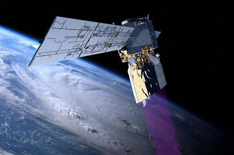
Tests carried out show that new wind profile observations from ESA’s Aeolus satellite significantly improve weather forecasts – particularly in the southern hemisphere and the tropics.
Improving new Aeolus wind data for forecasts
12.11.2019 17:09 ESA Observing the Earth
Tests carried out show that new wind profile observations from ESA’s Aeolus satellite significantly improves weather forecasts – particularly in the southern hemisphere and the tropics.
Referent/ka ZKN
12.11.2019 15:48 Zeměměřický úřad Zeměměřický úřadvypisuje výběrové řízení na místo
Referent/ka ZKN
Referent/ka ZKN
12.11.2019 15:48 ČÚZK - předpisy a opatření Zeměměřický úřadvypisuje výběrové řízení na místo
Referent/ka ZKN
Referent/ka ZKN
12.11.2019 15:48 ČÚZK - volná místa Zeměměřický úřad vypisuje výběrové řízení na místo Referent/ka ZKN20191112 rada/ odborný rada - právník v oddělení právních vztahů k nemovitostem
12.11.2019 14:52 ČÚZK /Urady/Katastralni-urady/Katastralni-urady/Katastralni-urad-pro-Stredocesky-kraj/Uredni-deska/Oznameni-a-jina-uredni-sdeleni/Volna-mista/20190828-Odborny-rada-oddeleni-pravnich-vztahu-(1)20191112 rada/ odborný rada - právník v oddělení právních vztahů k nemovitostem
12.11.2019 14:52 ČÚZK - předpisy a opatření Katastrální úřad pro Středočeský kraj - Katastrální pracoviště Mladá Boleslav Vyhlášení výběrového řízení: rada/ odborný rada - právník v oddělení právních vztahů k nemovitostem V části "Úřední deska", v sekci "Oznámení a jiná úřední sdělení" bylo vystaveno "Oznámení o vyhlášení výběrového řízení na obsazení systemizovaného místa rada/ odborný rada - právník v oddělení právních vztahů k nemovitostem"20191112 rada/ odborný rada - právník v oddělení právních vztahů k nemovitostem
12.11.2019 14:52 ČÚZK - předpisy a opatření Katastrální úřad pro Středočeský kraj - Katastrální pracoviště Mladá Boleslav Vyhlášení výběrového řízení: rada/ odborný rada - právník v oddělení právních vztahů k nemovitostem V části "Úřední deska", v sekci "Oznámení a jiná úřední sdělení" bylo vystaveno "Oznámení o vyhlášení výběrového řízení na obsazení služebního místa rada/ odborný rada - právník v oddělení právních vztahů k nemovitostem"20191112 rada/ odborný rada - právník v oddělení právních vztahů k nemovitostem
12.11.2019 14:50 ČÚZK /Urady/Katastralni-urady/Katastralni-urady/Katastralni-urad-pro-Stredocesky-kraj/Uredni-deska/Oznameni-a-jina-uredni-sdeleni/Volna-mista/20190828-Odborny-rada-oddeleni-pravnich-vztahu-(2)20191112 rada/ odborný rada - právník v oddělení právních vztahů k nemovitostem
12.11.2019 14:50 ČÚZK - předpisy a opatření Katastrální úřad pro Středočeský kraj - Katastrální pracoviště Mladá Boleslav Vyhlášení výběrového řízení: rada/ odborný rada - právník v oddělení právních vztahů k nemovitostem V části "Úřední deska", v sekci "Oznámení a jiná úřední sdělení" bylo vystaveno "Oznámení o vyhlášení výběrového řízení na obsazení služebního místa rada/ odborný rada - právník v oddělení právních vztahů k nemovitostem"20191112 rada/ odborný rada - právník v oddělení právních vztahů k nemovitostem
12.11.2019 14:43 ČÚZK - předpisy a opatření Katastrální úřad pro Středočeský kraj - Katastrální pracoviště Mladá Boleslav Vyhlášení výběrového řízení: rada/ odborný rada - právník v oddělení právních vztahů k nemovitostem V části "Úřední deska", v sekci "Oznámení a jiná úřední sdělení" bylo vystaveno "Oznámení o vyhlášení výběrového řízení na obsazení služebního místa rada/ odborný rada - právník v oddělení právních vztahů k nemovitostem"20191112 rada/ odborný rada - právník v oddělení právních vztahů k nemovitostem
12.11.2019 14:43 ČÚZK /Urady/Katastralni-urady/Katastralni-urady/Katastralni-urad-pro-Stredocesky-kraj/Katastralni-pracoviste/KP-Mlada-Boleslav/O-uradu/Aktuality/20190828-Odborny-rada-oddeleni-pravnich-vztahu-(2)rada/ odborný rada - právník v oddělení právních vztahů k nemovitostem
12.11.2019 14:41 ČÚZK - volná místa Katastrální úřad pro Středočeský kraj - Katastrální pracoviště Mladá Boleslav vypisuje výběrové řízení na místo rada/ odborný rada - právník v oddělení právních vztahů k nemovitostemrada/ odborný rada - právník v oddělení právních vztahů k nemovitostem
12.11.2019 14:41 ČÚZK - předpisy a opatření Katastrální úřad pro Středočeský kraj - Katastrální pracoviště Mladá Boleslavvypisuje výběrové řízení na místo rada/ odborný rada - právník v oddělení právních vztahů k nemovitostem
rada/ odborný rada - právník v oddělení právních vztahů k nemovitostem