


![]()

zprávy
zdroje zpráv:Jaký je Topcon GTL-1000? Zúčastněte se webináře, na kterém se dozvíte detaily
22.11.2019 18:51 GeoBusiness Web časopisu Zeměměřič informoval, že ve středu 27. listopadu se uskuteční webinář o TOPCON GTL-1000, což je integrovaný kompaktní skener s plně vybavenou robotickou totální stanicí. GTL-1000 je již nominován na ocenění za inovace a představuje revoluční řešení pro zachycení reality v reálném čase a jednodušší pracovní postup při ověřování stavebních konstrukcí. Dodavatelům na stavbě […]Webinář o GTL-1000 od Topconu
22.11.2019 18:37 ZeměměřičVe středu 27. listopadu se uskuteční webinář o TOPCON GTL-1000, což je integrovaný kompaktní skener s plně vybavenou robotickou totální stanicí. GTL-1000 je již nominován na ocenění za inovace a představuje revoluční řešení pro zachycení reality v reálném čase a jednodušší pracovní postup při ověřování konstrukcí. Dodavatelům na stavbě má pomáhat zvyšovat produktivitu, minimalizovat chyby a nepřekračovat náklady. Webinář bude v angličtině. Zde se […]
The post Webinář o GTL-1000 od Topconu appeared first on Zeměměřič.
20191122-VŘ Analytik-projektant
22.11.2019 15:23 ČÚZK - předpisy a opatření Český úřad zeměměřický a katastrální zveřejnil novou aktualitu: Oznámení o vyhlášení výběrového řízení na obsazení služebního místa Analytik/analytička - projekt/ka.20191122-VŘ Analytik-projektant
22.11.2019 15:23 ČÚZK /Aktuality-resort/2019/20191122-VR-Analytik-projektantAnalytik/analytička-projektant/ka
22.11.2019 14:29 ČÚZK - volná místa Český úřad zeměměřický a katastrální vypisuje výběrové řízení na místo Analytik/analytička-projektant/kaAnalytik/analytička-projektant/ka
22.11.2019 14:29 ČÚZK /Urady/Cesky-urad-zememericky-a-katastralni/Uredni-deska/Oznameni-a-jina-uredni-sdeleni/Volna-mista/DMS/Analytik-analyticka-projektant-kaAnalytik/analytička-projektant/ka
22.11.2019 14:29 ČÚZK - předpisy a opatření Český úřad zeměměřický a katastrálnívypisuje výběrové řízení na místo
Analytik/analytička-projektant/ka
Firmy při vývoji výrobků čím dál častěji spoléhají na digitální simulace
22.11.2019 14:03 Konstruktér Zájem o software pro simulace (CAE) v procesu vývoje výrobků se v posledních letech stále zvyšuje. Podle [...]Aktualizovaná mapa pozemkových úprav v SR
22.11.2019 14:00 Komora pozemkových úprav SR
Prinášame aktualizovanú prehľadnú mapu SR s vyznačením katastrálnych území, v ktorých sú ukončené alebo plánované pozemkové úpravy
Aktualizovaná prehľadná mapa pozemkových úprav v SR
22.11.2019 14:00 Komora pozemkových úprav SRPrinášame aktualizovanú prehľadnú mapu SR s vyznačením katastrálnych území, v ktorých sú ukončené alebo plánované pozemkové úpravy
Výběrové řízení inspektor/ka - právník (ZKI v Praze - obor služby 55.)
22.11.2019 13:48 ČÚZK - předpisy a opatření Zeměměřický a katastrální inspektorát v Praze zveřejnil novou aktualitu: Vyhlášení výběrového řízení na služební místo - Inspektor/ka - právník Zeměměřického a katastrálního inspektorátu v Praze (obor služby 55.)Výběrové řízení inspektor/ka - právník (ZKI v Praze - obor služby 55.)
22.11.2019 13:48 ČÚZK /Urady/Zememericke-a-katastralni-inspektoraty/Zememericke-a-katastralni-inspektoraty/Zememericky-a-katastralni-inspektorat-v-Praze/O-uradu/Aktuality/Vyberove-rizeni-inspektor-ka-pravnik-(ZKI-v-Pr-(2)Inspektor/ka – právník Zeměměřického a katastrálního inspektorátu v Praze (obor služby 55.)
22.11.2019 13:46 ČÚZK - volná místa Zeměměřický a katastrální inspektorát v Praze vypisuje výběrové řízení na místo Inspektor/ka – právník Zeměměřického a katastrálního inspektorátu v Praze (obor služby 55.)Inspektor/ka – právník Zeměměřického a katastrálního inspektorátu v Praze (obor služby 55.)
22.11.2019 13:46 ČÚZK /Urady/Zememericke-a-katastralni-inspektoraty/Zememericke-a-katastralni-inspektoraty/Zememericky-a-katastralni-inspektorat-v-Praze/Uredni-deska/Oznameni-a-jina-uredni-sdeleni/Volna-mista/DMS/Inspektor-ka-–-pravnik-Zememerickeho-a-katastralniInspektor/ka – právník Zeměměřického a katastrálního inspektorátu v Praze (obor služby 55.)
22.11.2019 13:46 ČÚZK - předpisy a opatření Zeměměřický a katastrální inspektorát v Prazevypisuje výběrové řízení na místo
Inspektor/ka – právník Zeměměřického a katastrálního inspektorátu v Praze (obor služby 55.)
Pracovník/nice hospodářské správy
22.11.2019 11:57 Zeměměřický úřad Zeměměřický úřadvypisuje výběrové řízení na místo
Pracovník/nice hospodářské správy
Pracovník/nice hospodářské správy
22.11.2019 11:57 ČÚZK - předpisy a opatření Zeměměřický úřadvypisuje výběrové řízení na místo
Pracovník/nice hospodářské správy
Pracovník/nice hospodářské správy
22.11.2019 11:57 ČÚZK - volná místa Zeměměřický úřad vypisuje výběrové řízení na místo Pracovník/nice hospodářské správyPracovník/nice hospodářské správy
22.11.2019 11:57 ČÚZK /Urady/Zememericky-urad/Volna-mista/Pracovnik-nice-hospodarske-spravyNový přijímač GNSS
22.11.2019 11:45 Středočeský kraj ro pracovníky krajského úřadu Středočeského kraje byl zakoupen nový ruční GNSS přijímač. Jedná se o model Trimble TDC150 Handheld a nahrazuje stávající zařízení GPS z roku 2005. Zařízení tohoto druhu používají pracovníci pro sběr prostorových dat, jako např. hraniční body ZCHÚ, významná výskytiště zvláště chráněných druhů, určení hranic pozemků pro umístění cyklotras, prověření umístění rozestavěné liniové stavby podle projektové dokumentace. Nový model umožňuje mapovat objekty s přesností až 10 cm. Součástí dodávky bylo i odborné zaškolení obsluhy. Nyní je zaškoleno 8 pracovníků z různých odborů, zejména Odboru životního prostředí a zemědělství, Odboru majetku, Odboru dopravy a Odboru územního plánování a stavebního řádu. Zakoupením tohoto zařízení se očekává vyšší úroveň kvality sběru prostorových dat a tím vyšší efektivita při rozhodovacích procesech. Výběrové řízení na dodávku zboží zajistil Odbor informatiky.Hexagon Wins World Smart City Award
22.11.2019 11:24 GISCafe.com Webcasts-Webinars Smart City Expo World Congress recognizes efforts to connect satellite and operational data and trigger predictive maintenance for …Seville, Spain
22.11.2019 10:00 ESA Observing the Earth Image:
Ahead of next week’s ‘Space19+’ Ministerial Council, the Copernicus Sentinel-2 mission takes us over Seville in southern Spain – the destination for this milestone event.
On 27–28 November, Ministers from ESA’s Member States along with Associate Member Slovenia and Cooperating State Canada will meet in Seville for the ESA Council at Ministerial Level Space19+ to discuss future space activities for Europe and the budget of Europe’s space agency for the coming three years. Space19+ is an opportunity to direct Europe’s ‘next generation’ ambitions in space, and address the challenges facing not only the European space sector, but also European society as a whole.
Seville, visible towards the top right of this image, is the capital of Andalusia and the fourth largest city in Spain. An inland port, it lies on the Guadalquivir River and while the original course of the river is visible snaking through the city on the right, we can see where water has also been redirected into a straighter course on the left. At over 650 km long, the Guadalquivir is one of the longest rivers in Spain, extending way beyond the frame of this image. Nevertheless, it can be seen winding its course all the way from the top right of the image, just south of the Sierra Norte mountain range, to the Gulf of Cádiz where it empties into the Atlantic Ocean. On route, this major river serves as a source for irrigation – here noticeable in the top right of the image, but mainly to the south of Seville where large green agricultural fields appear in sharp contrast to the surrounding drier brown land.
The Doñana National Park lies on the right bank of the Guadalquivir River, at its estuary on the Atlantic Ocean. One of Europe's most important wetland reserves, the park is an area of marsh, shallow streams and sand dunes, and an important site for endangered and migrating birds.
Copernicus Sentinel-2 is a two-satellite mission. Each satellite carries a high-resolution camera that images Earth’s surface in 13 spectral bands. Data from Copernicus Sentinel-2 are used to monitor changes in land cover, agriculture, and coastal and inland waters.
This image, captured on 21 June 2019, is also featured on the Earth from Space video programme.
Earth from Space: Seville
22.11.2019 10:00 ESA Observing the Earth Video:
00:02:39
Video:
00:02:39
In this week's edition of the Earth from Space programme, the Copernicus Sentinel-2 mission takes us over Seville in southern Spain, where ESA's next Ministerial Council will soon take place.
See also Seville, Spain to download the image.
Olofoto album
22.11.2019 9:04 Katedra geoinformatiky UP OlomoucTradiční OLOFOTO z letošní Konference GIS Esri v ČR nově naleznete v našem albu: https://photos.app.goo.gl/1eD8GRrLQVYFuGadA Album budeme průběžně aktualizovat a přidávat fotky i z minulých let.
The post Olofoto album appeared first on Katedra geoinformatiky.
Ohlédnutí za GIS Esri – den 2
22.11.2019 8:59 GISportal.cz
Konference GIS Esri v ČR se tradičně koná během dvou dnů. Letos to bylo 6. a 7. listopadu s podtitulem See What Others Can’t. V předchozím článku jsme vás informovali, co se dělo během úvodního dne, dnes se dozvíte to nejzajímavější ze dne druhého, kdy se dění rozdělilo do všech tří sálů pražského kongresového centra. Čí […]
The post Ohlédnutí za GIS Esri – den 2 appeared first on GISportal.cz.
Ouster Lidar Powers Next Generation Security and Safety Solutions
22.11.2019 3:20 GISCafe.com Webcasts-Webinars Ouster integrates with leading security perception platforms to enable real-time 3D perception, with night vision and 360-degree coverageSAN …
INSPIRE téma Rozšířené Parcely (CPX)
22.11.2019 1:00 Cenia - Katalog metadat ČR - INSPIRE Rozšíření má za cíl poskytovat katastrální mapu s obsahem podle vyhlášky ve vektorové podobě ve struktuře plně v souladu se strukturou danou směrnicí INSPIRE. Data rozšiřují směrnici INSPIRE pro téma katastrální parcely (CP) o věcná břemena, geodetické body, další prvky mapy, původní obloukovou geometrii a o parcely určené definičním bodem (ty pouze v oblastech s analogovou mapou). Vychází z katastrální mapy, která je závazným státním mapovým dílem velkého měřítka, obsahuje body polohového bodového pole, polohopis a popis a může mít formu digitální mapy, analogové mapy nebo digitalizované mapy. Publikovaná data obsahují katastrální území pro celou Českou Republiku, parcely a jejich hranice, věcná břemena, další prvky mapy a původní obloukovou geometrii z území, kde je digitální mapa (k 18. 11. 2019 je to 96,64% území České republiky, t.j. 76 215,40km2) a ve zbytku území katastrální parcely určené pouze definičním bodem (tedy bez hranic a polygonu). Katastrální parcely a hranice obsahují oproti datové sadě INSPIRE některé atributy navíc. Jedná se o typ hranice, způsob využití území, druh pozemku, vazbu na budovu a o mapové značky. Více katastrální zákon 344/1992 SB., katastrální vyhláška č.26/2007 Sb. v platném znění a INSPIRE Data Specification on Cadastral Parcels v 3.0.1. Data ve formátu GML 3.2.1 jsou validní proti schématu XML pro Rozšířené Parcely (CPX) ve verzi 4.0.Katastrální mapa ve formátech DGN a DXF poskytovaná v e-shopu
22.11.2019 1:00 Cenia - Katalog metadat ČR - INSPIRE Katastrální mapa je závazným státním mapovým dílem velkého měřítka, obsahuje body polohového bodového pole, polohopis a popis. Katastrální mapa ve vektorové podobě je poskytována zdarma ve formátu DGN a DXF a obsahuje prvky Digitální katastrální mapy (DKM) a Katastrální mapy digitalizované (KMD), tedy bodová pole, budovy, další prvky mapy, hranice parcel, katastrální hranice, parcely katastru nemovitostí, prvky orientační mapy a hranice věcného břemene. Z důvodu použití formátu DGN produkt neobsahuje značky na liniích a oblouky jsou nahrazeny lomenými čárami. Katastrální mapa ve vektorové podobě k 18. 11. 2019 pokrývá 96,64% území České republiky, t.j. 76 215,40km2. Více katastrální vyhláška č.357/2013 Sb. v platném znění.Katastrální mapa v rastrové podobě poskytovaná v e-shopu
22.11.2019 1:00 Cenia - Katalog metadat ČR - INSPIRE Katastrální mapa v rastrové podobě je poskytována za úplatu a obsahuje analogovou mapu s kompletní kresbou. Analogová mapa pokrývá 3,21 % území České republiky, což je 2 534,82km2. Více katastrální vyhláška č.357/2013 Sb. v platném znění.Pozvánka na akci „První zkušenosti z revizí katastru, věcná břemena“
21.11.2019 21:41 Spolek zeměměřičů Brno Dobrý den, Český svaz geodetů a kartografů vás zve na velice zajímavou odbornou akci „První zkušenosti z revizí katastru, věcná břemena“, která se bude konat ve středu 15.ledna 2020 v Praze 1, Novotného lávka 5. Bližší informace jsou na přiložené pozvánce Pozvánka – První zkušenosti s revizí Elektronická přihláška: http://csgk.fce.vutbr.cz/Oakce/A120 Těšíme... Read more »Linda van den Brink receives OGC’s 2019 Gardels Award
21.11.2019 20:32 GISCafe.com Webcasts-Webinars Congratulations to Linda van den Brink, awarded the 2019 Gardels Award for being “an outstanding representative both internal to OGC and …Manatee County Selects Industry Leader Hexagon to Deploy Public Safety Systems in the Cloud
21.11.2019 18:22 Hexagon Safety & InfrastructureManatee County, Florida, has selected Hexagon’s Safety & Infrastructure division to migrate its public safety systems to the cloud with HxGN OnCall, a comprehensive portfolio of next-generation public safety solutions.
The project, expected to go live in 2020, will support all police, fire and EMS agencies by upgrading the county’s computer-aided dispatch (CAD), mobile and analytics systems to SaaS deployments of HxGN OnCall solutions on Microsoft Azure. The move will help Manatee County increase flexibility and gain access to the most advanced public safety technologies available. It will also increase efficiency by replacing major system upgrades with more frequent updates, provide disaster recovery applications and, most importantly, help agencies better protect and serve the community.
A long-time customer of Hexagon, Manatee County was instrumental in the development of the new HxGN OnCall portfolio, which officially launched in June 2019. The team participated in a pilot program for the software, offering helpful feedback throughout the process.
“We are proud to support Manatee County in their move to the cloud and are grateful for the vital role they played during the development of HxGN OnCall, our new portfolio of next-gen public safety solutions,” said Ben Ernst, vice president and general manager of U.S. Public Safety for Hexagon’s Safety & Infrastructure division. “The Manatee County team is well-respected among public safety leaders and known for their innovative initiatives, making them the ideal partner for developing a solution that will transform the industry.”
“Moving our public safety systems to the cloud has been a priority for our organization, and partnering with Hexagon gives us peace of mind to make the leap,” said Jacob Saur, director of public safety, Manatee County Government. “As a Hexagon customer for 20 years, we are excited to begin this new chapter with an organization we can trust and that has the industry experience to deliver a solution that fits our needs today and in the future.”
To modernize systems and improve service quality, Manatee County will deploy HxGN OnCall Dispatch, HxGN OnCall Analytics, HxGN OnCall Dispatch | Mobile Unit and HxGN OnCall Dispatch | Mobile Responder.
For more information about HxGN OnCall managed service solutions, visit www.hexagonsafetyinfrastructure.com/managedservice.
Digital Global Systems Joins Nevada-Global Drone Trade Alliance
21.11.2019 17:55 GISCafe.com Webcasts-Webinars TYSONS, Va., Nov. 20, 2019 — (PRNewswire) — Digital Global Systems Inc. (DGS) has partnered with the Nevada Institute for …Maxar Commends Senate Commerce Committee’s Passage of NASA Authorization Bill
21.11.2019 17:55 GISCafe.com Webcasts-Webinars WESTMINSTER, Colo. — (BUSINESS WIRE) — November 21, 2019 —Maxar Technologies (NYSE:MAXR) (TSX:MAXR), a trusted partner and …
Blickfeld to debut full automotive LiDAR suite at CES 2020
21.11.2019 17:55 GISCafe.com Webcasts-Webinars Live demonstrations in Las Vegas to include CES 2020 Innovation Awards Honoree Blickfeld CubeMUNICH — (BUSINESS WIRE) — November 21, …
ČÚZK v pátek 22.11.2019 od 15:
21.11.2019 17:12 GEUSware ČÚZK v pátek 22.11.2019 od 15:00 do 19:00 zcela přeruší provoz Dálkového přístupu (DP) i Webových služeb dálkového přístupu (WSDP). Z tohoto důvodu budou v GEUSu nefunkční Podklady měření a Odesílání GP.Smoke in New South Wales
21.11.2019 17:00 ESA Observing the Earth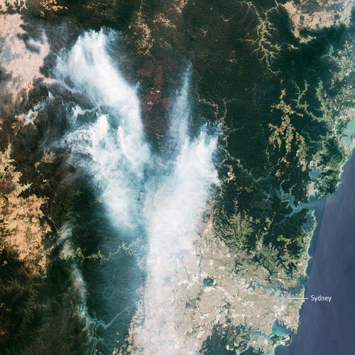 Image:
The Copernicus Sentinel-2 mission captured the plumes of smoke from the bushfires in Australia. The recent blazes triggered a ‘hazardous’ air quality warning for Sydney – the highest level on Australia’s Air Quality Index.
In this image, captured on 21 November 2019 at 00:02 GMT (11:02 local time), smoke from the Gospers Mountain bushfires, northwest of Sydney, can be seen drifting southwards. Residents with respiratory conditions were advised by authorities to stay indoors, as over 50 people have been treated owing to complications from the smoke.
According to the New South Wales Rural Fire Service, as of 21:00 local time, there were over 60 bush and grass fires burning in New South Wales, of which over 20 still need to be contained. In Victoria, another 60 blazes are burning – although the exact number is unknown as new fires have been sparked by recent lightning.
Hundreds of bushfires have been burning this month in Australia, with the greatest damage seen in New South Wales and Queensland.
KÚ-05946/2019
21.11.2019 15:21 ČÚZK - předpisy a opatření Katastrální úřad pro hlavní město Prahu - Katastrální pracoviště Praha zveřejnil novou aktualitu: Ředitel úřadu vyhlašuje výběrové řízení na služební místo: rada/odborný rada - právníkKÚ-05946/2019
21.11.2019 15:21 ČÚZK /Urady/Katastralni-urady/Katastralni-urady/Katastralni-urad-pro-hlavni-mesto-Prahu/O-uradu/Aktuality/KU-05946-2019rada/odborný rada - právník
21.11.2019 15:17 ČÚZK - předpisy a opatření Katastrální úřad pro hlavní město Prahu - Katastrální pracoviště Prahavypisuje výběrové řízení na místo
rada/odborný rada - právník
rada/odborný rada - právník
21.11.2019 15:17 ČÚZK - volná místa Katastrální úřad pro hlavní město Prahu - Katastrální pracoviště Praha vypisuje výběrové řízení na místo rada/odborný rada - právníkrada/odborný rada - právník
21.11.2019 15:17 ČÚZK /Urady/Katastralni-urady/Katastralni-urady/Katastralni-urad-pro-hlavni-mesto-Prahu/Uredni-deska/Oznameni-a-jina-uredni-sdeleni/Volna-mista/DMS/rada-odborny-rada-pravnik-(1)Seminář o prvních zkušenostech s revizemi KN
21.11.2019 15:12 ZeměměřičČeský svaz geodetů a kartografů zve na seminář „První zkušenosti z revizí katastru, věcná břemena“. Akce se bude konat ve středu 15. ledna 2020 (budova ČSVTS, Novotného lávka 5, Praha 1, kongresový sál č. 319). Akce začíná v 9:30 hod, předpokládaný konec je odpoledne v 15 hod. I. BLOK 9:30 až 11:00 hod. 1. Úvod – Ing. Karel Švarc, KÚ 2. Revize […]
The post Seminář o prvních zkušenostech s revizemi KN appeared first on Zeměměřič.
Firma Geotech použila lidar pro skenování sjezdovky
21.11.2019 14:51 GeoBusiness Web časopisu Zeměměřič informoval o použití lidaru lidaretto pro skenování průběhu lyžařské sjezdovky. Slovenská firma Geotech použila své vlastní lidarové řešení (více o lidarettu v rozhovoru s Erikem Frohmannem). Na videu geodeti skenují sjezdovky ve ski resortu Štrbské Pleso ve Vysokých Tatrách. Jako nejvhodnější varianta měření se ukázala pěší chůze s lidarettem na zádech. Výsledný […]EU space infrastructure guarantees leadership in security and defence
21.11.2019 14:24 European GNSS Agency
The European Union’s space infrastructure and know-how provide the assets needed to guarantee leadership in the area of security and defence policy. At a meeting of the European Parliament's Subcommittee on Security and Defence (SEDE) on 12 November European GNSS Agency (GSA) Chief Operating Officer Pascal Claudel spoke about how the European Union's space programmes contribute to its strategic autonomy in the area of security and defence.
Galileo, EGNOS and Copernicus offer the European Union and its Member States the fundamental tools needed for independence in decision-making through the navigation, localisation, Earth observation, communication and surveillance services that they provide.
SEDE Committee Chair Nathalie Loiseau opened the meeting with a comment on the security and defence dimension of space, noting that Europe’s economies, societies, infrastructures and public services policies are becoming more and more dependent on space. “Space has become a critical strategic element for developed societies. This makes us vulnerable, so we need to be aware of this in our security and defence policy,” she said.
In his speech at the meeting, Claudel noted that the new Regulation on the space programme passed in April further strengthens the link between space, defence and security by creating synergies between the fields of navigation, Earth observation and communication. “These synergies will lead to improved applications for the detection and fight against global natural disasters,” he said.
Essential culture of security
Claudel also noted that the development of space surveillance, the Space Situational Awareness (SSA) programme, is essential for ensuring the protection of the EU's space capabilities. The SSA programme is designed to support Europe's independent access and utilisation of space by providing timely and accurate information on the space environment, and particularly hazards to in-orbit and ground infrastructure.
Read this: Europe’s economy is increasingly dependent on space - ITRE committee hears
“Security is one of the 3 major missions entrusted to the GSA, including the Security Accreditation Board (SAB). Although an independent entity, the SAB is supported by the GSA in its mission, which is to ensure compliance between European GNSS standards and the safety regulations of the European Union,” Claudel said.
He said that, in order to strengthen the EU's Security and Defence Policy, a security culture at the service of the EU's space programmes is essential. “The experience gained by the GSA through the operations of Galileo in terms of security (including cybersecurity) is fundamental to reinforce synergies and the sharing of space resources in the service of our security and security policy,” he said.
Cornerstone of government space use
Along with security, the GSA COO also touched on the other 2 key areas in which the GSA has acquired solid experience that can be put to the service of all the EU’s space programmes when the Agency’s remit is broadened under the aegis of the European Union Agency for the Space Programme (EUSPA). These are the PRS and Critical Infrastructure.
The Galileo Public Regulated Service (PRS) is an encrypted navigation service for governmental authorised users and sensitive applications that require high continuity. “The PRS service is the cornerstone for governmental use of the European space programmes. It is delivered through a security chain adapted to the needs of the EU Member States and of the European Union.” Claudel said.
And this: PRS – the future is bright!
He said that this requires continuity of services, efficient operational procedures and a high level of security to protect the entire infrastructure and its communications to end users. “The experience gained from the PRS will be crucial for the handling of Galileo navigation, GovSatCom telecommunication and SSA space surveillance information,” he said.
Essential for strategic autonomy
Regarding the protection of critical infrastructures and their synchronisation with satellite navigation systems, he noted that this synchronisation is currently mainly provided by GPS. “It is therefore important that legislation establishes Galileo ahead of time as the main provider of services, in order to ensure autonomy,” he said, adding that this is particularly important in the context of internal security, transport, energy and telecommunications.
As space policy is an essential dimension of our strategic autonomy, it is essential to preserve the EU’s sensitive technological and industrial capabilities, which means that it is necessary to be very present on the civilian market because of the difference in terms of budget spending by our competitors, he said.
“This is also why a key goal of the GSA is to promote and stimulate the use of European GNSS in all sectors of the market, thus guaranteeing a work plan for our industry and SMEs, job creation and growth at European level,” he said.
Media note: This feature can be republished without charge provided the European GNSS Agency (GSA) is acknowledged as the source at the top or the bottom of the story. You must request permission before you use any of the photographs on the site. If you republish, we would be grateful if you could link back to the GSA website (http://www.gsa.europa.eu).
EU space infrastructure guarantees leadership in security and defence
21.11.2019 14:24 European GNSS AgencyThe European Union’s space infrastructure and know-how provide the assets needed to guarantee leadership in the area of security and defence policy. At a meeting of the European Parliament's Subcommittee on Security and Defence (SEDE) on 12 November European GNSS Agency (GSA) Chief Operating Officer Pascal Claudel spoke about how the European Union's space programmes contribute to its strategic autonomy in the area of security and defence.
Galileo, EGNOS and Copernicus offer the European Union and its Member States the fundamental tools needed for independence in decision-making through the navigation, localisation, Earth observation, communication and surveillance services that they provide.
SEDE Committee Chair Nathalie Loiseau opened the meeting with a comment on the security and defence dimension of space, noting that Europe’s economies, societies, infrastructures and public services policies are becoming more and more dependent on space. “Space has become a critical strategic element for developed societies. This makes us vulnerable, so we need to be aware of this in our security and defence policy,” she said.
In his speech at the meeting, Claudel noted that the new Regulation on the space programme passed in April further strengthens the link between space, defence and security by creating synergies between the fields of navigation, Earth observation and communication. “These synergies will lead to improved applications for the detection and fight against global natural disasters,” he said.
Essential culture of security
Claudel also noted that the development of space surveillance, the Space Situational Awareness (SSA) programme, is essential for ensuring the protection of the EU's space capabilities. The SSA programme is designed to support Europe's independent access and utilisation of space by providing timely and accurate information on the space environment, and particularly hazards to in-orbit and ground infrastructure.
Read this: Europe’s economy is increasingly dependent on space - ITRE committee hears
“Security is one of the 3 major missions entrusted to the GSA, including the Security Accreditation Board (SAB). Although an independent entity, the SAB is supported by the GSA in its mission, which is to ensure compliance between European GNSS standards and the safety regulations of the European Union,” Claudel said.
He said that, in order to strengthen the EU's Security and Defence Policy, a security culture at the service of the EU's space programmes is essential. “The experience gained by the GSA through the operations of Galileo in terms of security (including cybersecurity) is fundamental to reinforce synergies and the sharing of space resources in the service of our security and security policy,” he said.
Cornerstone of government space use
Along with security, the GSA COO also touched on the other 2 key areas in which the GSA has acquired solid experience that can be put to the service of all the EU’s space programmes when the Agency’s remit is broadened under the aegis of the European Union Agency for the Space Programme (EUSPA). These are the PRS and Critical Infrastructure.
The Galileo Public Regulated Service (PRS) is an encrypted navigation service for governmental authorised users and sensitive applications that require high continuity. “The PRS service is the cornerstone for governmental use of the European space programmes. It is delivered through a security chain adapted to the needs of the EU Member States and of the European Union.” Claudel said.
And this: PRS – the future is bright!
He said that this requires continuity of services, efficient operational procedures and a high level of security to protect the entire infrastructure and its communications to end users. “The experience gained from the PRS will be crucial for the handling of Galileo navigation, GovSatCom telecommunication and SSA space surveillance information,” he said.
Essential for strategic autonomy
Regarding the protection of critical infrastructures and their synchronisation with satellite navigation systems, he noted that this synchronisation is currently mainly provided by GPS. “It is therefore important that legislation establishes Galileo ahead of time as the main provider of services, in order to ensure autonomy,” he said, adding that this is particularly important in the context of internal security, transport, energy and telecommunications.
As space policy is an essential dimension of our strategic autonomy, it is essential to preserve the EU’s sensitive technological and industrial capabilities, which means that it is necessary to be very present on the civilian market because of the difference in terms of budget spending by our competitors, he said.
“This is also why a key goal of the GSA is to promote and stimulate the use of European GNSS in all sectors of the market, thus guaranteeing a work plan for our industry and SMEs, job creation and growth at European level,” he said.
Media note: This feature can be republished without charge provided the European GNSS Agency (GSA) is acknowledged as the source at the top or the bottom of the story. You must request permission before you use any of the photographs on the site. If you republish, we would be grateful if you could link back to the GSA website (http://www.gsa.europa.eu).
Sjezdovky a lidar. Podívejte se na slovenské Lidaretto v akci
21.11.2019 14:13 ZeměměřičSlovenská firma Geotech na svém Youtube kanálu představila možnost využití jejich lidarového řešení lidaretto pro měření na sjezdovkách. Po průchodu s lidarem na zádech získá zákazník 3D model z laserového skenování. Na videu geodeti skenují sjezdovky ve ski resortu Štrbské Pleso ve Vysokých Tatrách. Jako nejvhodnější varianta měření se ukázala pěší chůze s lidarettem na zádech. Tento 3D model […]
The post Sjezdovky a lidar. Podívejte se na slovenské Lidaretto v akci appeared first on Zeměměřič.
Valné zhromaždenie KPÚ SR
21.11.2019 12:37 Komora pozemkových úprav SR
Dňa 5.12.2019 sa uskutoční Valné zhromaždenie KPÚ SR vo Zvolene, v hoteli Tenis
Rada/Odborný rada – Vedoucí oddělení aktualizace katastru nemovitostí
21.11.2019 11:23 ČÚZK /Urady/Katastralni-urady/Katastralni-urady/Katastralni-urad-pro-Karlovarsky-kraj/Uredni-deska/Oznameni-a-jina-uredni-sdeleni/Volna-mista/Rada-Odborny-rada-–-Vedouci-oddeleni-aktualizace-kRada/Odborný rada – Vedoucí oddělení aktualizace katastru nemovitostí
21.11.2019 11:23 ČÚZK - volná místa Katastrální úřad pro Karlovarský kraj - Katastrální pracoviště Sokolov vypisuje výběrové řízení na místo Rada/Odborný rada – Vedoucí oddělení aktualizace katastru nemovitostíRada/Odborný rada – Vedoucí oddělení aktualizace katastru nemovitostí
21.11.2019 11:23 ČÚZK - předpisy a opatření Katastrální úřad pro Karlovarský kraj - Katastrální pracoviště Sokolovvypisuje výběrové řízení na místo
Rada/Odborný rada – Vedoucí oddělení aktualizace katastru nemovitostí
ESIP and OGC invite you to the Coverage Processing and Analysis API Sprint
21.11.2019 11:10 GISCafe.com Webcasts-Webinars Agile development sprint will advance APIs for analytics on coverages, arrays, and gridded data.November 20, 2019: Earth Science Information …
Schneider electric announces a new powerful, feature-filled release of Arcfm designer xi
21.11.2019 11:07 GISCafe.com Webcasts-Webinars Latest release seamlessly supports electric and gas networks, as well as the Utility Network and UPDMFort Collins, Colo., November 20, …
Target for ArcGIS Pro enhances integration of mining and exploration data
21.11.2019 10:27 GISCafe.com Webcasts-Webinars Industry-first tool enables geoscientists to find what’s hidden faster with seamless integration of subsurface drilling and …Manatee County Selects Industry Leader Hexagon to Deploy Public Safety Systems in the Cloud
21.11.2019 1:00 Hexagon Safety & Infrastructure HxGN OnCall managed service solutions to increase efficiency and provide access to the most advanced public safety technologiesINSPIRE – Zóny a aglomerace hodnocení a řízení kvality ovzduší / Air quality management zones and agglomerations
21.11.2019 1:00 Cenia - Katalog metadat ČR - INSPIRE Vrstva zón a aglomerací hodnocení a řízení kvality ovzduší na území České republiky. Zóny a aglomerace jsou vymezeny na základě legislativních specifikací Směrnice EU 2008/50/EC a zákona č. 201/2012 Sb., o ochraně ovzduší. Zónou je území vymezené MŽP pro účely sledování a řízení kvality ovzduší; aglomerací je sídelní seskupení, v němž žije nejméně 250 000 obyvatel. Zákon o ochraně ovzduší stanovuje tři aglomerace a sedm zón (obr. I.3). Podrobnosti pak dále specifikuje vyhláška č. 330/2012 Sb., o způsobu posuzování a vyhodnocení úrovně znečištění, rozsahu informováníveřejnosti o úrovni znečištění a při smogových situacích.Manatee County Selects Industry Leader Hexagon to Deploy Public Safety Systems in the Cloud
21.11.2019 1:00 Hexagon Safety & Infrastructure HxGN OnCall managed service solutions to increase efficiency and provide access to the most advanced public safety technologiesSeismické profily
21.11.2019 1:00 Cenia - Katalog metadat ČR - INSPIRE Databáze obsahuje informace o seismických profilech odměřených na území České republiky z prostředků státního rozpočtu. Reflexně seismické profily, registrované digitálně jsou uloženy ve formátu SEGY. Databáze obsahuje cca tisíc těchto profilů. Informace o refrakčních profilech, profilech hlubinné seismické sondáže (HSS) a reflexně seismických profilech registrovaných analogově jsou dostupné v posudcích archivu ČGS (ASGI).Cultural entities for INSPIRE
21.11.2019 1:00 Cenia - Katalog metadat ČR - INSPIRE Artificial dataset, comprised of polygonal entities of cultural monuments, protected areas, their buffer zones and sites of world heritageManatee County Selects Industry Leader Hexagon to Deploy Public Safety Systems in the Cloud
21.11.2019 1:00 Hexagon Safety & Infrastructure HxGN OnCall managed service solutions to increase efficiency and provide access to the most advanced public safety technologies
Ve čtvrtek 10.11. 2019 proběhlo 74. setkání členů SFDP
20.11.2019 23:46 Společnost pro fotogrammetrii a dálkový průzkumVe čtvrtek 10.11. 2019 proběhlo 74. setkání členů SFDP. Po příjezdu do Ostravy byl zajištěn odvoz do muzea „Důl Michal“ . Zde jsme absolvovali velice zajímavou prohlídku s důrazeme na důlní měřictví a význam tohoto dolu v historickém kontextu Ostravy. Podrobné webové stránky muzea jsou: https://www.dul-michal.cz/cs
The post Ve čtvrtek 10.11. 2019 proběhlo 74. setkání členů SFDP appeared first on SFDP.
USGIF 2020 Awards Program Now Open
20.11.2019 21:20 GISCafe.com Webcasts-Webinars The Foundation annually recognizes outstanding achievements in the Geospatial Intelligence CommunityHerndon, Virginia (November 20, 2019)—The …
More States to Integrate Mapping Technology into Elections Systems as NSGIC Project Moves into Second Phase
20.11.2019 21:15 GISCafe.com Webcasts-Webinars November 20, 2019National States Geographic Information Council (NSGIC) has been awarded $300,000 by the bipartisan Democracy Fund Voice …
Bentley Systems to Discuss Digital Twins for Digitally Advanced Cities and Digital Construction Solutions at BIM World Munich 2019
20.11.2019 18:54 Bentley SystemsBIM World Munich 2019
Bentley Systems’ booth# 1 together with Topcon and VenturisIT
Bentley Systems on the Microsoft booth# 47 together with RIB and robotic eyes
26 – 27 November 2019
ICM Munich – International Congress Center
West Entrance
Am Messesee
81823 Munich, Germany
Join Bentley Systems at BIM World Munich 2019 in Munich, Germany to learn about digital construction and digital twins for digitally advanced cities.
Visit us at booth 1 and booth 47 throughout the conference for demonstrations and discussions on the following topics:
Digital Construction – focusing on the use of a mixed reality solution for 4D construction
featuring Bentley’s SYNCHRO (4D construction software) with Microsoft HoloLens.
Digital Cities – demonstrating how Bentley’s OpenCities Planner software enables visualization
of 2D, 3D, and GIS data in a 3D world to make city-scale digital twins broadly accessible.
Civil Design – made better through Bentley’s open applications—OpenRoads, OpenSite and
OpenRail, for improved design, analysis, and performance of civil design projects.
Scheduled Presentations
Lutz Bettels, Vice President, Regional Executive Europe, Bentley Systems
Keynote – Congress Stage 1
Title: From BIM to Twin. From Vision to Reality. From Ideas to Action.
Abstract: This presentation discusses BIM and digital twins, how they fit together, and how the technology will continue to advance the design, construction, operations, and maintenance of infrastructure.
Language: English
Wednesday, 27 November 2019; 10:30 – 11 a.m.
Anna Assama, Construction Solutions Engineer, Bentley Systems
Breakout Session
Title: Mixed Reality for Construction: Use Cases for an Augmented Jobsite
Language: English
Tuesday, 26 November 2019; 3:30 - 4:00 p.m.
Anna Assama, Construction Solutions Engineer, Bentley Systems
Microsoft Partner Session
Title: Getting to Real-Time: Digital Feedback Loops for Construction
Language: English
Wednesday, 27 November 2019; 12:00 - 1:00 p.m.
For Interviews
Lutz Bettels, Vice President, Regional Executive Europe for Bentley Systems is available for interviews by appointment.
Contact information
To schedule an interview, or for additional details about the event, please contact christinevk@chriscrossrelations.de.
Additional information:
Digital Twins and iTwin™ Services
SYNCHRO XR and Microsoft HoloLens2
Bentley Systems’ Design Integration Offerings Advance BIM to 4D through Digital Twins
Bentley Systems Announces New iTwin Cloud Services for Infrastructure Engineering Digital Twins
Bentley Systems’ New ProjectWise 365 and Comprehensive SYNCHRO Offerings Advance 4D Digital Twins for Project Delivery
About Bentley Systems
Bentley Systems is the leading global provider of software and digital twin solutions to engineers, architects, geospatial professionals, constructors, and owner-operators for the design, construction, and operations of infrastructure. Bentley Systems employs more than 3,500 colleagues, generates annual revenues of $700 million in 170 countries, and has invested more than $1 billion in research, development, and acquisitions since 2014. www.bentley.com
Topcon Solutions Stores Announce Partnership Plan With Autodesk to Expand Platinum-level Service to All North American Locations
20.11.2019 18:00 GISCafe.com Webcasts-Webinars LAS VEGAS — (BUSINESS WIRE) — November 19, 2019 —Topcon Positioning Group announces a new strategy through their Topcon Solutions …
Salesforce Selects Esri as Key Geospatial Partner
20.11.2019 18:00 GISCafe.com Webcasts-Webinars REDLANDS, California, November 20, 2019 – Today at Dreamforce, Esri, the global leader in mapping and location intelligence, announced that …TraceAir and Independent Construction Start Their 25th Joint Project at Placer Vineyards
20.11.2019 18:00 GISCafe.com Webcasts-Webinars The collaboration is aimed at preventing cost overruns at construction site and making drone data-driven decisionsREDWOOD CITY, Calif., Nov. 20, …
Salesforce Selects Esri as Key Geospatial Partner
20.11.2019 18:00 GISCafe.com Webcasts-Webinars REDLANDS, Calif. — (BUSINESS WIRE) — November 20, 2019 —Today at Dreamforce, Esri, the global leader in mapping and location …
Tennessee Aquarium-Led, International Team Develops Interactive Map of World's Turtle Communities
20.11.2019 18:00 GISCafe.com Webcasts-Webinars Freshwater turtles are one of the world's most imperiled groups of animals. The Tennessee Aquarium and an international team of collaborators …Tennessee Aquarium-Led, International Team Develops Interactive Map of World's Turtle Communities
20.11.2019 18:00 GISCafe.com Webcasts-Webinars Freshwater turtles are one of the world's most imperiled groups of animals. The Tennessee Aquarium and an international team of collaborators have …Bentley Systems to cover smart city technology at Intergeo 2019
20.11.2019 15:29 Bentley SystemsPress Coverage
GPS World, USA
Read the articleIgnore FM’s digital future at your peril
20.11.2019 15:24 Bentley SystemsPress Coverage
Construction News, UK
Read the articleDigital Twins and Collaborative Growth
20.11.2019 15:18 Bentley SystemsPress Coverage
ARC Advisory Group, USA
Read the articleKYTC Can Issue Overweight/Over Dimensional Permits Online
20.11.2019 15:14 Bentley SystemsPress Coverage
SurfKY, USA
Read the articleDigitalization: Welcome to the City 4.0
20.11.2019 15:11 Bentley SystemsPress Coverage
Daily Tech Digest, USA
Read the articleThe Construction Industry Meets Technology Disruption – Finally
20.11.2019 14:52 Bentley SystemsPress Coverage
CleanTech, USA
Read the articleRada / Odborný rada – vedoucí oddělení metodiky, kontroly a personalistiky kanceláře ředitele Katast
20.11.2019 14:02 ČÚZK - předpisy a opatření Katastrální úřad pro Královéhradecký krajvypisuje výběrové řízení na místo
Rada / Odborný rada – vedoucí oddělení metodiky, kontroly a personalistiky kanceláře ředitele Katastrálního úřadu pro Královéhradecký kraj
Rada / Odborný rada – vedoucí oddělení metodiky, kontroly a personalistiky kanceláře ředitele Katast
20.11.2019 14:02 ČÚZK /Urady/Katastralni-urady/Katastralni-urady/Katastralni-urad-pro-Kralovehradecky-kraj/Uredni-deska/Oznameni-a-jina-uredni-sdeleni/Volna-mista/Rada-Odborny-rada-–-vedouci-oddeleni-metodiky,-kRada / Odborný rada – vedoucí oddělení metodiky, kontroly a personalistiky kanceláře ředitele Katast
20.11.2019 14:02 ČÚZK - volná místa Katastrální úřad pro Královéhradecký kraj vypisuje výběrové řízení na místo Rada / Odborný rada – vedoucí oddělení metodiky, kontroly a personalistiky kanceláře ředitele KatastJaká byla Konference GIS Esri v ČR 2019?
20.11.2019 13:30 ARCDATANejvětší setkáních GIS odborníkův ČR je za námi a my vám nyní přinášíme přehledný souhrn všechno, co zde bylo vidění. Na stránkách konference aktuálně naleznete například:
- přehled všech příspěvků včetně prezentací v PDF,
- výsledky posterové a družicové soutěže,
- náhledy posterů,
- sborník konference.
Na sociálních sítích si dále můžete prohlédnout:
- fotogalerii umístěnou na Facebookové stránce akce
- a více než 13 hodin přednášek a workshopů na našem YouTube kanálu.

"Cityworks and Nearmap Partner to Add HD-Quality Visuals to Public Asset Management" by Susan Smith
20.11.2019 11:17 GISCafe.com Webcasts-WebinarsInvitation to tender: EGNOS service for payment and liability-critical road applications
20.11.2019 10:35 European GNSS Agency
The European Commission’s Directorate-General for Internal Market, Industry, Entrepreneurship and SMEs (DG GROW) has issued an Invitation To Tender (ITT) for a service contract on using satellite-based augmentation systems (SBAS) for applications such as road tolling or pay-as-you-drive insurance with the aim of developing an appropriate integrity concept for payment/liability critical applications focused on the road sector.
The main tasks of the study are the identification of user and service requirements, the development of an appropriate integrity concept and the definition of the service provision scheme. As part of the user level integrity concept the contractor shall develop an algorithm to cope with the local environment of the road sector.
When defining the service, the contractor shall consider to which extent evolutions of the EGNOS services, user equipment or of the service provision scheme are needed to provide the required integrity assurance. Integrity in this context refers to the level of confidence that can be put in the navigation solution. The On-Board Unit (OBU) will have to allow all the features necessary to trust the position in situations where enforcement, payments and related claims are involved. Since the E-GNSS sensor may just be one component among other sensors, the project shall address what other technologies or components may be needed on top of the current GNSS signals, and what would be the contribution of each element to the overall integrity assurance.
The study will be fully financed by the European Commission under the H2020 framework programme for research and innovation, within the budget allocated to the evolution of EGNOS mission. The European GNSS Agency (GSA) will be in charge of the technical supervision of the project on behalf of the European Commission.
More information about the Invitation to tender can be found here.
Tailored premiums
Pay-as-you-drive (PAYD) and pay-how-you-drive (PHYD) insurance are emerging applications in the road sector that rely on how much, where, when and how the road user drives. These applications make it possible to tailor the premiums paid by the policyholder.
Read this: European GNSS supports smarter mobility
In the future, other road applications such as reconstruction of accidents, mobility as a service, traffic infraction monitoring and fine management, traffic congestion monitoring, automatic charging in car parks, etc. may also rely on the vehicle’s position and navigation data.
Liability and payment-critical applications are highly sensitive to undetected large navigation errors since significant legal or economic consequences for the service or application provider may occur. In fact, a mismatch of the vehicle’s current speed together with erroneous position data may impact the user charging associated with the driving paths, skills and habits of the road user. Afterwards, it becomes very difficult for end users to claim that they are being overcharged or for service providers to avoid undercharging their customers.
Webinar
On 27 November 2019 at 16:00 CET, a webinar on this invitation to tender will be held to provide applicants with information. To register to the webinar click here.
EGNOS is the European SBAS and augments the GPS L1 C/A civilian signal by providing corrections and integrity information for positioning and navigation applications over Europe. EGNOS Version 3, set to enter in service in the near future, will augment both GPS and Galileo constellations in the L1 and L5 bands and will extend the service area to the entire landmasses of EU Member States.
Media note: This feature can be republished without charge provided the European GNSS Agency (GSA) is acknowledged as the source at the top or the bottom of the story. You must request permission before you use any of the photographs on the site. If you republish, we would be grateful if you could link back to the GSA website (http://www.gsa.europa.eu).
Omezení provozu
20.11.2019 9:59 ČÚZK /Urady/Katastralni-urady/Katastralni-urady/Katastralni-urad-pro-Vysocinu/Katastralni-pracoviste/KP-Zdar-nad-Sazavou/O-uradu/Aktuality/Omezeni-provozu-(1)Omezení provozu
20.11.2019 9:59 ČÚZK - předpisy a opatření Katastrální úřad pro Vysočinu - Katastrální pracoviště Žďár nad Sázavou zveřejnil novou aktualitu: Katastrální úřad pro Vysočinu, Katastrální pracoviště Žďár nad Sázavou oznamuje, že dne 29.11.2019 od 7.00 do 12.00 hodin bude z důvodu výluky elektrické energie omezen provoz.Děkujeme za pochopení.
Geoinformatika v médiích – rozhovor s doc. Burianem o geoinformatice
20.11.2019 8:30 GISportal.cz
Po zajímavém prvním díle GeoTalks, kde olomoucký doc. Burian představoval geoinformatiku následuje další rozhovor tohoto odborníka na GIS v územním plánování, tentokrát pro místní rádio Proglas. V cyklu Z regionálních studií byl hostem pořadu Geoinformatika v praxi. A jak propagujete náš obor vy? Napište nám a mi rádi zveřejníme odkaz na Vaše články/rozhovory!
The post Geoinformatika v médiích – rozhovor s doc. Burianem o geoinformatice appeared first on GISportal.cz.
Předseda APG vystoupil na ideové konferenci ODS
20.11.2019 8:11 Asociace podnikatelů v geomatice Předseda APG Martin Hrdlička byl pozván na ideovou konferenci ODS s názvem Reforma státu, která se konala v sobotu 9. listopadu 2019 v Brně. Hlavním tématem konference bylo téma digitalizace stavebního řízení. Předseda představil APG jako hlavního garanta realizace digitální DTM ČR a i dalších procesů v rámci digitalizace stavebnictví. Zdůraznil rovněž potřebu urychlit zahájení realizace tvorby DTM.Google Impact Challenge selects Nevada Institute for Autonomous Systems for Innovative Workforce Development Program
20.11.2019 1:41 GISCafe.com Webcasts-Webinars LAS VEGAS, November 19, 2019 /NIASNewswire/ -- The Nevada Institute for Autonomous Systems (NIAS) was selected as a Google Impact Challenge winner …Prohlížecí služba WMS - Data200
20.11.2019 1:00 Cenia - Katalog metadat ČR - INSPIRE Prohlížecí služba WMS - Data200 je poskytována jako veřejná prohlížecí služba nad daty produktu Topografická databáze České republiky (Data200). Služba splňuje Technické pokyny pro INSPIRE prohlížecí služby v. 3.11 a zároveň splňuje standard OGC WMS 1.1.1. a 1.3.0. Databáze Data200 je digitální geografický model území České republiky (ČR) odpovídající přesností a stupněm generalizace měřítku 1:200 000. Data200 je zpracována v rozsahu celého území České republiky, vznikla na základě projektu EuroRegionalMap (ERM) evropského sdružení civilních zeměměřických a mapových služeb EuroGeographics. Zpracování ERM za Českou republiku zajišťuje Zeměměřický úřad od roku 2005. Data200 jsou od dubna 2019 poskytována jako otevřená data ve formátu SHP.Prohlížecí služba Esri ArcGIS Server - Data200
20.11.2019 1:00 Cenia - Katalog metadat ČR - INSPIRE Prohlížecí služba AGS - Data200 je poskytována jako veřejná prohlížecí služba nad daty produktu Topografická databáze České republiky (Data200). Databáze Data200 je digitální geografický model území České republiky (ČR) odpovídající přesností a stupněm generalizace měřítku 1:200 000. Data200 je zpracována v rozsahu celého území České republiky, vznikla na základě projektu EuroRegionalMap (ERM) evropského sdružení civilních zeměměřických a mapových služeb EuroGeographics. Zpracování ERM za Českou republiku zajišťuje Zeměměřický úřad od roku 2005. Data200 jsou od dubna 2019 poskytována jako otevřená data ve formátu SHP.Prohlížecí služba Esri ArcGIS Server - Data50
20.11.2019 1:00 Cenia - Katalog metadat ČR - INSPIRE Prohlížecí služba AGS-Data50 je poskytována jako veřejná prohlížecí služba nad daty topografické databáze České republiky Data50. Kartografická vizualizace objektů vychází z podoby Základní mapy 1:50 000. Služba může být využita jako vektorová podkladová mapa ČR pro měřítka od cca 1:60 000 do cca 1:25 000.APGEO - PŘEDSEDA APG VYSTOUPIL NA IDEOVÉ KONFERENCI ODS
20.11.2019 1:00 Asociace podnikatelů v geomatice Předseda APG Martin Hrdlička byl pozván na ideovou konferenci ODS s názvem Reforma státu, která se konala v ...Software Development Kits now available for Global Mapper and the LiDAR Module
19.11.2019 21:58 GISCafe.com Webcasts-Webinars Version 21 of the Global Mapper® Software Development Kit (SDK) released with the ability to generate point clouds from UAV …Surbana Jurong inks MOUs on built environment
19.11.2019 21:56 Bentley SystemsPress Coverage
The Straits Times
Read the article‘Transformative’ urban digital twin and city modelling deployments to exceed 500 by 2025, says ABI
19.11.2019 21:53 Bentley SystemsPress Coverage
IoT Now, UK
Read the articleOrbit GT and Cybernetech, Japan, sign Reseller Agreement
19.11.2019 21:53 GISCafe.com Webcasts-Webinars Lokeren, Belgium, October 19th, 2019Orbit GT is pleased to announce that Cybernetech, Japan, has joined as Authorized Reseller of Orbit GT 3D …
Digital Twins for Digital Cities
19.11.2019 21:50 Bentley SystemsPress Coverage
The Civil Engineering Podcast, US
Read the articleTCEP 127: Digital Twins for Digital Cities
19.11.2019 21:48 Bentley SystemsPress Coverage
The Civil Engineering Podcast, US
Read the articleHakan Engman meets with GISCafe at InterGeo
19.11.2019 21:45 Bentley SystemsPress Coverage
GISCafe/AECCafe, US
Read the articleTed Lamboo meets with GISCafe at InterGeo
19.11.2019 21:43 Bentley SystemsPress Coverage
GISCafe/AECCafe, US
Read the articleAssetino Cloud Based Cemetery Mapping & Management Tool Launched
19.11.2019 19:06 GISCafe.com Webcasts-Webinars November 19, 2019 -- T-MAPY, the company behind the award winning cloud based Assetino asset management suite, has launched an international version …Accela Deepens Integration with Esri and Microsoft to Leverage Spatial Data and Cloud Analytics to Empower Governments to Make Data-Driven Decisions and Enhance Citizen Services
19.11.2019 19:05 GISCafe.com Webcasts-Webinars Collaboration between technology powerhouses helps local and state governments deliver what's possible in fostering economic development and …BOXX Demos Workstations and Introduces New System at Autodesk University
19.11.2019 19:05 GISCafe.com Webcasts-Webinars AUSTIN, TEXAS, Nov. 19, 2019 (GLOBE NEWSWIRE) -- BOXX Technologies, the leading innovator of high-performance computer workstations, rendering …FLIR Introduces StormCaster Payload Family for its SkyRaider and SkyRanger Unmanned Aerial Systems
19.11.2019 19:05 GISCafe.com Webcasts-Webinars Next-Generation Line of UAS Payloads Delivers High-Performance, Multi-Sensor Capabilities for ISR, Event Overwatch, Search and Rescue, and Force …EarthCam's A.I. Technology Advances Autodesk Integration with Improved 3D Model and 360° Reality Capture Alignment
19.11.2019 19:05 GISCafe.com Webcasts-Webinars EarthCam, the leading provider of construction camera technology and services, today announced at Autodesk University a new feature set that …Vislink Selected to Supply California Law Enforcement Agency with U.S.-Designed and Manufactured Drone Solution
19.11.2019 19:05 GISCafe.com Webcasts-Webinars Integrated System Featuring the New MicroLite 3 was Chosen for its Security and Interoperability with Regional Agencies HACKETTSTOWN, NJ, Nov. …OpenSpace Announces New Integrations with Autodesk® BIM 360® Software
19.11.2019 19:05 GISCafe.com Webcasts-Webinars Customers will be able to create RFIs and Issues from directly within job site photo documentationSAN FRANCISCO, Nov. 19, 2019 — (PRNewswire) …
Panzura and AVAIL Partner to Enable Real-World, Global Collaboration on BIM Content
19.11.2019 19:05 GISCafe.com Webcasts-Webinars Industry-Leading Bundle Empowers Distributed AEC Teams to Work Faster, More Efficiently Towards Successful Project DeliveriesCAMPBELL, Calif., Nov. …
SEMINÁŘ KE GEOPORTÁLU INSPIRE - 3. 12. 2019
19.11.2019 14:39 CENIA - národní geoportál INSPIRE CENIA, česká informační agentura životního prostředí, Vás zve na seminář ke sběru uživatelských požadavků pro nový Geoportál INSPIRE. Akce se bude konat dne 3. 12. 2019 od 10:00 do 12:30 v budově Ministerstva životního prostředí, Vršovická 1442/65, Praha 10, místnost 900. Novinkou tohoto semináře bude také přenos online, prostřednictvím kterého se budete moci zapojit i ze své kanceláře nebo z...Join the future of navigation at ESA’s NAVISP Industry Days
19.11.2019 14:24 ESA Navigation
The ability to know where you are and where you’re going is central to today’s society, and will only grow more crucial in future. ESA’s NAVISP R&D programme is building on Europe’s technical accomplishments to develop new future positioning, navigation and timing technologies and services – its annual Industry Days next January will give a snapshot of the programme’s progress.
Latest updates to Reports on User Needs and Requirements released
19.11.2019 14:08 European GNSS Agency
The European GNSS Agency (GSA) has released updates to its Reports on User Needs and Requirements. This series of reports is compiled following a systematic process of consultation with the community of users of position, navigation, and time services and technologies. Thanks to these consultations it is possible to take users’ needs and requirements into account in the short and long-term evolution of European GNSS.
The current round of updates to the reports was compiled based on feedback received from the user community at the latest European GNSS User Consultation Platform, held during EU Space Week in Marseille in December 2018. You can find the updated reports here.*
To make it easier for readers to see what has changed, all the updated information in the reports has been highlighted. What’s more, a detailed change log has been included as an annex to each of the reports and is available for download. The new reports have been designated Version 2.0.
A taste of what’s newAgriculture: the policy and regulatory framework has been updated to reflect the new CAP update which opens novel opportunities for EGNSS solutions. What’s more, a specific mention has been made regarding repeatability and integrity in connection with the applications that these mainly apply to and there has been a clarification around the quoted values of accuracy. To read the updated report in full, click here. Location-based Services: accuracy and coverage parameters have been refined and the corresponding users’ requirements quantification has been updated. The Augmented Reality category has also been refined and new applications have been added (Augmented Reality for leisure, Augmented Reality for professional applications, Robotics), along with their user requirements. To read the updated report in full, click here. Rail: Definition of GNSS use in rail safety relevant applications is still ongoing, so the user requirements for rail have to be considered as a work in progress. That said, several recommendations were made by the Rail panel during UCP 2018 for consideration in the future versions of the report. In particular: some applications were removed for redundancy reasons (such as train warning or ATP) and some applications have been modified from safety-relevant to non-safety. To read the updated report in full, click here. Road: previously unreferenced requirements have been validated and other requirements have been revised. Furthermore, the regulatory context has been updated to take into account the latest EU Regulation. To read the updated report in full, click here. Surveying: sections of the text were optimised and updated to reflect additions and clarifications on topics along with technology developments (open and proprietary formats for PPP, RTK and PPP-RTK; Open Sky vs. harsh environment; requirements table; Galileo HAS for surveying; raw measurements on Android; and software-based GNSS and Positioning-as-a-Service techniques). A further analysis on specific requirements for the integration of GNSS with LiDAR, RPAS, AR and other emerging technologies has also been included. To read the updated report in full, click here. Time & Synchronisation: the increasing demand for calibration of hardware equipment delays for both scientific and industrial applications has been included as a new driver. Moreover, there is a more precise characterisation of robustness against spoofing, along with an introduction of the potential T&S needs for 5G networks and an updated regulatory context. To read the updated report in full, click here. |
The User Consultation Platform
The User Consultation Platform (UCP) is a biennial forum, organised by the European Commission and the GSA, involving end users, user associations and representatives of the value chain, such as receiver and chipset manufacturers, application developers and the organisations and institutions dealing, directly and indirectly, with Galileo and EGNOS. The event is a part of the process developed at the GSA to collect user needs and requirements and take them as inputs for the provision of user-driven Galileo and EGNOS services.
The next UCP will take place in 2020. In the meantime, on 3-5 December 2019, European Space Week will take place in Helsinki. This event will include an “E-GNSS User Assembly” where the latest trends in services and technologies will be discussed.
Join us in the ongoing discussion and ensure that future European space programme evolutions meet your needs and requirements by registering to attend European Space Week here.
*Updates to the Aviation and Maritime reports are still pending at this point.
Media note: This feature can be republished without charge provided the European GNSS Agency (GSA) is acknowledged as the source at the top or the bottom of the story. You must request permission before you use any of the photographs on the site. If you republish, we would be grateful if you could link back to the GSA website (http://www.gsa.europa.eu).
20191119 - Nedostupnost změnových souborů VFR
19.11.2019 11:33 ČÚZK - předpisy a opatření Oznámení pro uživatele změnových VFR:Vlivem technické chyby nedošlo k vygenerování změnového souboru za pondělí 18. 11. 2019. Změny byl měly být obsahem změnového VF za 19. 11. 2019. Omlouváme se za případné komplikace.
Zveřejněno 19. 11. 2019
20191119 - Nedostupnost změnových souborů VFR
19.11.2019 11:33 ČÚZK /Uvod/Produkty-a-sluzby/RUIAN/2-Poskytovani-udaju-RUIAN-ISUI-VDP/Vymenny-format-RUIAN/Archiv-novinek-VFR/20191119-Nedostupnost-zmenovych-souboru-VFROhlédnutí za GIS Esri – den 1
19.11.2019 9:57 GISportal.czLetošní konference GIS Esri v ČR pořádaná firmou ARCDATA Praha se konala 6. a 7. listopadu v Praze. Je největším setkáním geoinformatiků v Česku s více než pětadvacetiletou tradicí, kde se účastníci seznamují s novinkami v oboru GIS ve veřejném i privátním sektoru. Právě ročník 2019 s podtitulem See What Others Can’t slavil rekordní účast 1 […]
The post Ohlédnutí za GIS Esri – den 1 appeared first on GISportal.cz.