


![]()

zprávy
zdroje zpráv:Podpořili jsme akci “Divadélkování ve Ville Hrdlička”
29.11.2019 12:08 Hrdlička Naše společnost se stala partnerem akce "Divadélkování ve ville Hrdlička", kterou pořádá Horizont HG 2014. z.ú za podpory České Lípy.Firemní teambuilding v Rakousku jsme zvládli bez újmy
29.11.2019 12:04 Hrdlička Jako již tradičně jsme se v září vydali na firemní turistickou teambuildingovou akci do Rakouska na horu Pasterze.HRDLIČKA spol. s r.o. - Firemní teambuilding v Rakousku jsme zvládli bez újmy
29.11.2019 12:04 Hrdlička Jako již tradičně jsme se v září vydali na firemní turistickou teambuildingovou akci do Rakouska na horu Pasterze.HRDLIČKA spol. s r.o. - UtilityReport je součástí státního Portálu občana, vedený MV
29.11.2019 12:04 Hrdlička UtilityReport je aplikace, zjednodušující proces vyjádření k existenci technické infrastruktury (inženýrských sítí, telekomunikací…)UtilityReport je součástí státního Portálu občana, vedený MV
29.11.2019 12:04 Hrdlička UtilityReport je aplikace, zjednodušující proces vyjádření k existenci technické infrastruktury (inženýrských sítí, telekomunikací…)Podzimní grilovačka na naší zahradě se vyvedla na jedničku
29.11.2019 11:59 Hrdlička Poslední pátek v září jsme pořádali tradiční firemní neformální akci Grilovačka na centrále společnosti v Praze.HRDLIČKA spol. s r.o. - Podzimní grilovačka na naší zahradě se vyvedla na jedničku
29.11.2019 11:59 Hrdlička Poslední pátek v září jsme pořádali tradiční firemní neformální akci Grilovačka na centrále společnosti v Praze.HRDLIČKA spol. s r.o. - Digitalizace a aktualizace dokumentace v Německu
29.11.2019 11:57 Hrdlička Vyhráli jsme výběrové řízení německé energetické společnosti Westnetz.Digitalizace a aktualizace dokumentace v Německu
29.11.2019 11:57 Hrdlička Vyhráli jsme výběrové řízení německé energetické společnosti Westnetz.Ceny pozemkových úprav
29.11.2019 11:36 Komora pozemkových úprav SR
Ceny projektov pozemkových úprav (PPÚ) boli v poslednom čase hojne diskutovanou témou, a to na strane dodávateľov (projektantov, geodetických firiem...) i verejnosti (štátna správa, opozícia...). Jedným sa javia pdhodnotené, iným naopak nadhodnotené. Nezaškodí preto pripomenúť si, ako vznikali, čo malo na ich...
Cena pozemkových úprav
29.11.2019 11:36 Komora pozemkových úprav SRAký je vzťah cien PPÚ k vývoju ekonomiky, resp. nie je vhodný čas na ich revíziu?
Ceny pozemkových úprav
29.11.2019 11:36 Komora pozemkových úprav SRAký je vzťah cien PPÚ k vývoju ekonomiky, resp. nie je vhodný čas na ich revíziu?
Horizon 2020 key to international cooperation for Galileo & EGNOS
29.11.2019 10:54 European GNSS Agency
Use of European GNSS (Galileo and EGNOS, EGNSS) is not restricted to Europe’s borders, and the compatibility of space systems means that users and businesses around the globe are able to benefit from greater coverage, higher accuracy and more confidence in their position fixes thanks to EGNSS. International users are therefore interested in exploring opportunities for greater cooperation with the European space programmes. Horizon 2020 is a key entry point for this.
Horizon 2020 and its successor framework programme Horizon Europe offer excellent opportunities for organisations around the world to team up with entities in the European Union to conduct research and development in a wide range of areas. European GNSS (EGNSS) is one such area and the EGNSS downstream market, in particular, is an ideal forum for international cooperation, with advantages for both sides in terms of new markets and business opportunities.
In this context, participation in Horizon 2020 Calls is an effective driver of international cooperation that strengthens existing and creates new links with non-EU countries. Any H2020 project can include international partners and international participation in these projects brings multiple benefits, including access to knowledge, markets, talent and investment, better research and exploitation and a higher global profile for the projects. Through previous R&I initiatives GSA has established cooperation with a wide network of international EGNSS players and the objective is to strengthen the existing and upcoming link with more countries.
Applicants from non-EU countries are eligible to take part in Horizon 2020 programmes – even if the calls for proposals or topic texts do not explicitly state this. However, they are not always automatically entitled to funding. For a list of countries eligible for Horizon 2020 funding, click here.
Creating international partnerships
EGNSS-related projects funded under Horizon 2020 have already yielded significant successes. One such project is BELS and its successor BELS+. The BELS+ consortium brings together partners from Europe and Southeast Asia with the aim of developing GNSS markets for EU companies in Southeast Asia and helping EGNSS applications gain a foothold in this rapidly growing market. Towards this goal, the project conducts a range of coordinated activities to raise awareness and build capacities for the exploitation of EGNSS technologies in the region.
Watch this: Galileo Hackathon Bangalore
Likewise, the European GNSS Agency (GSA)-funded GNSS.asia H2020 project aims to stimulate the creation of partnerships between GNSS industries in Europe and Asia, while supporting institutional cooperation and encouraging Galileo adoption. The project is dedicated to GNSS industrial cooperation between Europe and the Asia-Pacific region, with a focus on the downstream market. The project offers various services, including industry matchmaking and international cooperation events, and has permanent teams in Europe, India, China, Taiwan, South Korea and Japan.
Another example of successful international EGNSS cooperation is the MAGNIFIC project. The core aim of MAGNIFIC (Multiplying in Africa European Global Navigation Initiatives Fostering Interlaced Cooperation), which was funded in the Horizon 2020 1st Galileo call, was to demonstrate the benefits of EGNSS to African stakeholders. The project focused in particular on six priority markets: road, aviation, maritime, precision, agriculture/environment protection, civil protection and surveillance, and LBS.
Read this: Bavaria rings to the sound of BELS+
Last chance before Horizon Europe
Horizon 2020 will draw to a close in 2020, but there is still time to take advantage of the opportunities for international cooperation in the final EGNSS market uptake 2019-2020 Call. This Call, with a total budget of EUR 21 million, opened on 5 November.
Dealing with the development of new innovative applications fostering digitisation, smart mobility, societal resilience and environmental protection and with a brand new topic tailored to public authorities, this is the last Horizon 2020 Call before the launch of its successor framework programme – Horizon Europe.
For more information on the final EGNSS market uptake call, click here. The deadline for submissions is 5 March 2020.
Do you need support in getting in touch with non-EU partners? We can help, as we have particularly active links with:
- UAE, Oman, Saudi Arabia
- Northern African countries: Morocco, Algeria, Tunisia, Libya, Egypt
- South Africa
- ASECNA countries
- Israel, Lebanon, Jordan
- Ukraine, Georgia, Azerbaijan, Moldavia
- South America: Brazil, Chile, Argentina, Uruguay
- Central America: Mexico, Costar Rica, Panama
- Vietnam, Malaysia, South Korea, Japan.
- Australia, New Zealand.
We would be happy to discuss with you, contact us at RESEARCH@gsa.europa.eu!
Media note: This feature can be republished without charge provided the European GNSS Agency (GSA) is acknowledged as the source at the top or the bottom of the story. You must request permission before you use any of the photographs on the site. If you republish, we would be grateful if you could link back to the GSA website (http://www.gsa.europa.eu).
Rozhovor s novým výrobním ředitelem Ing. Petrem Pavelkou
29.11.2019 10:07 Hrdlička Od 1. ledna 2019 se stal výrobním ředitelem společnosti HRDLIČKA spol. s r. o. Ing. Petr Pavelka.HRDLIČKA spol. s r.o. - Rozhovor s novým výrobním ředitelem Ing. Petrem Pavelkou
29.11.2019 10:07 Hrdlička Od 1. ledna 2019 se stal výrobním ředitelem společnosti HRDLIČKA spol. s r. o. Ing. Petr Pavelka.Earth from Space: Lake St. Clair
29.11.2019 10:00 ESA Observing the Earth Video:
00:02:39
Video:
00:02:39
In this week's edition of the Earth from Space programme, the Copernicus Sentinel-2 mission takes us over Lake St. Clair, forming the border between Ontario, Canada to the east, and Michigan, US to the west.
See also Lake St. Clair to download the image.
Lake St. Clair
29.11.2019 10:00 ESA Observing the Earth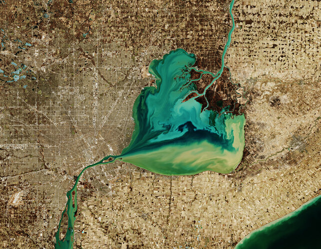 Image:
The Copernicus Sentinel-2 mission takes us over Lake St. Clair, forming the border between Ontario, Canada to the east, and Michigan, US to the west.
The Saint Clair River is visible at the top of the image and flows southwards, connecting the southern end of Lake Huron with Lake St. Clair, visible in the centre of the image. The river branches into several channels before reaching the lake, creating a seven-mouth delta. Much of the area surrounding the delta is used for agriculture.
The Thames River, visible east of the lake, begins in a swampy area of Ontario, before emptying its muddy waters into Lake St. Clair. Here the murky-coloured waters mix with the turquoise waters from the Saint Clair River, creating this fusion of colour visible in the heart-shaped lake. The waters then exit the lake via the Detroit River.
Lake St. Clair is approximately 40 km long and 40 km wide, with an average depth of around 3 metres. The lake is a popular site for fishing and boating, and more than 100 species of fish inhabit the lake including walleye, rainbow trout and muskellunge.
Detroit, the largest city in Michigan, is visible directly above the Detroit River. The city lies on a relatively flat plain and its extensive network of roads in the city are clearly visible in the image.
Detroit is nicknamed the “motor city” as it was the key hub for American auto-manufacturing for over a century. It was also home to the first mile of concrete highway, the first four-way three-colour traffic light and the world’s first urban freeway.
In this wintery image, captured on 26 March 2019, many of the frozen lakes northwest of the lake can be seen partially frozen over. The Copernicus Sentinel-2 mission allows inland bodies of water to be closely monitored.
This image is also featured on the Earth from Space video programme.
Otevírací doba v prosinci [Knihovna geografie, byTopic]
29.11.2019 9:35 Katedra aplikované geoinformatiky a kartografie Přf UK Informace o zkrácení otevírací doby Knihovny geografie v prosinci 2019DIN Innovators Award for Datacube Inventor Peter Baumann
29.11.2019 9:00 GISCafe.com Webcasts-Webinars November 25, 2019 -- Never before has so much information about the Earth been available to mankind. Every day, satellites provide an enormous amount …Upozornění
29.11.2019 8:50 ČÚZK /Urady/Katastralni-urady/Katastralni-urady/Katastralni-urad-pro-Plzensky-kraj/Katastralni-pracoviste/KP-Plzen-sever/O-uradu/Aktuality/UpozorneniUpozornění
29.11.2019 8:50 ČÚZK - předpisy a opatření Katastrální úřad pro Plzeňský kraj - Katastrální pracoviště Plzeň-sever zveřejnil novou aktualitu: UPOZORNĚNÍDne 31. 12. 2019 lze z technických důvodů správní poplatky uhradit pouze kolkovými známkami, bezhotovostním převodem na účet nebo platebními kartami.
Upozornění
29.11.2019 8:49 ČÚZK /Urady/Katastralni-urady/Katastralni-urady/Katastralni-urad-pro-Plzensky-kraj/Katastralni-pracoviste/KP-Plzen-mesto/O-uradu/Aktuality/UpozorneniUpozornění
29.11.2019 8:49 ČÚZK - předpisy a opatření Katastrální úřad pro Plzeňský kraj - Katastrální pracoviště Plzeň-město zveřejnil novou aktualitu: UPOZORNĚNÍDne 31. 12. 2019 lze z technických důvodů správní poplatky uhradit pouze kolkovými známkami, bezhotovostním převodem na účet nebo platebními kartami.
Upozornění
29.11.2019 8:47 ČÚZK - předpisy a opatření Katastrální úřad pro Plzeňský kraj - Katastrální pracoviště Plzeň-jih zveřejnil novou aktualitu: UPOZORNĚNÍDne 31. 12. 2019 lze z technických důvodů správní poplatky uhradit pouze kolkovými známkami, bezhotovostním převodem na účet nebo platebními kartami.
Upozornění
29.11.2019 8:47 ČÚZK /Urady/Katastralni-urady/Katastralni-urady/Katastralni-urad-pro-Plzensky-kraj/Katastralni-pracoviste/KP-Plzen-jih/O-uradu/Aktuality/UpozorneniUpozornění
29.11.2019 8:45 ČÚZK - předpisy a opatření Katastrální úřad pro Plzeňský kraj - Katastrální pracoviště Tachov zveřejnil novou aktualitu: UPOZORNĚNÍVe dnech 27. - 31. 12. 2019 lze z technických důvodů správní poplatky uhradit pouze kolkovými známkami, bezhotovostním převodem, nebo platebními kartami
Upozornění
29.11.2019 8:45 ČÚZK - předpisy a opatření Katastrální úřad pro Plzeňský kraj - Katastrální pracoviště Tachov zveřejnil novou aktualitu: UPOZORNĚNÍVe dnech 23. - 31. 12. 2019 lze z technických důvodů správní poplatky uhradit pouze kolkovými známkami, bezhotovostním převodem, nebo platebními kartami
Upozornění
29.11.2019 8:45 ČÚZK /Urady/Katastralni-urady/Katastralni-urady/Katastralni-urad-pro-Plzensky-kraj/Katastralni-pracoviste/KP-Tachov/O-uradu/Aktuality/UpozorneniUpozornění
29.11.2019 8:43 ČÚZK - předpisy a opatření Katastrální úřad pro Plzeňský kraj - Katastrální pracoviště Rokycany zveřejnil novou aktualitu: UPOZORNĚNÍVe dnech 23. - 31. 12. 2019 lze z technických důvodů správní poplatky uhradit pouze kolkovými známkami, bezhotovostním převodem, nebo platebními kartami
Upozornění
29.11.2019 8:43 ČÚZK /Urady/Katastralni-urady/Katastralni-urady/Katastralni-urad-pro-Plzensky-kraj/Katastralni-pracoviste/KP-Rokycany/O-uradu/Aktuality/UpozorneniUpozornění
29.11.2019 8:43 ČÚZK - předpisy a opatření Katastrální úřad pro Plzeňský kraj - Katastrální pracoviště Rokycany zveřejnil novou aktualitu: UPOZORNĚNÍVe dnech 27. - 31. 12. 2019 lze z technických důvodů správní poplatky uhradit pouze kolkovými známkami, bezhotovostním převodem, nebo platebními kartami
Upozornění
29.11.2019 8:42 ČÚZK - předpisy a opatření Katastrální úřad pro Plzeňský kraj - Katastrální pracoviště Kralovice zveřejnil novou aktualitu: UPOZORNĚNÍVe dnech 27. - 31. 12. 2019 lze z technických důvodů správní poplatky uhradit pouze kolkovými známkami, bezhotovostním převodem, nebo platebními kartami
Upozornění
29.11.2019 8:42 ČÚZK /Urady/Katastralni-urady/Katastralni-urady/Katastralni-urad-pro-Plzensky-kraj/Katastralni-pracoviste/KP-Kralovice/O-uradu/Aktuality/UpozorneniUpozornění
29.11.2019 8:42 ČÚZK - předpisy a opatření Katastrální úřad pro Plzeňský kraj - Katastrální pracoviště Kralovice zveřejnil novou aktualitu: UPOZORNĚNÍVe dnech 23. - 31. 12. 2019 lze z technických důvodů správní poplatky uhradit pouze kolkovými známkami, bezhotovostním převodem, nebo platebními kartami
Upozornění
29.11.2019 8:41 ČÚZK /Urady/Katastralni-urady/Katastralni-urady/Katastralni-urad-pro-Plzensky-kraj/Katastralni-pracoviste/KP-Klatovy/O-uradu/Aktuality/UpozorneniUpozornění
29.11.2019 8:41 ČÚZK - předpisy a opatření Katastrální úřad pro Plzeňský kraj - Katastrální pracoviště Klatovy zveřejnil novou aktualitu: UPOZORNĚNÍVe dnech 23. - 31. 12. 2019 lze z technických důvodů správní poplatky uhradit pouze kolkovými známkami, bezhotovostním převodem, nebo platebními kartami.
Upozornění
29.11.2019 8:41 ČÚZK - předpisy a opatření Katastrální úřad pro Plzeňský kraj - Katastrální pracoviště Klatovy zveřejnil novou aktualitu: UPOZORNĚNÍVe dnech 27. - 31. 12. 2019 lze z technických důvodů správní poplatky uhradit pouze kolkovými známkami, bezhotovostním převodem, nebo platebními kartami.
HRDLIČKA spol. s r.o. - Získali jsme certifikát společensky odpovědné firmy
29.11.2019 8:38 Hrdlička Ve spolupráci se společností Remobil jsme se zapojili do projektu pro ochranu životního prostředí..Získali jsme certifikát společensky odpovědné firmy
29.11.2019 8:38 Hrdlička Ve spolupráci se společností Remobil jsme se zapojili do projektu pro ochranu životního prostředí..Upozornění
29.11.2019 8:35 ČÚZK - předpisy a opatření Katastrální úřad pro Ústecký kraj - Katastrální pracoviště Domažlice zveřejnil novou aktualitu: UPOZORNĚNÍVe dnech 27. - 31. 12. 2019 lze z technických důvodů správní poplatky uhradit pouze kolkovými známkami, bezhotovostním převodem, nebo platebními kartami.
Upozornění
29.11.2019 8:35 ČÚZK /Urady/Katastralni-urady/Katastralni-urady/Katastralni-urad-pro-Plzensky-kraj/Katastralni-pracoviste/KP-Domazlice/O-uradu/Aktuality/UpozorneniUpozornění
29.11.2019 8:35 ČÚZK - předpisy a opatření Katastrální úřad pro Ústecký kraj - Katastrální pracoviště Domažlice zveřejnil novou aktualitu: UPOZORNĚNÍVe dnech 23. - 31. 12. 2019 lze z technických důvodů správní poplatky uhradit pouze kolkovými známkami, bezhotovostním převodem, nebo platebními kartami.
INSPIRE Protected sites - other
29.11.2019 1:00 Cenia - Katalog metadat ČR - INSPIRE This data set contains two groups of spatial data:1) Buffer Zones. These Buffer Zones of Specially Protected Areas are proclaimed in accordance with Section 37 of the Act No. 114/1992 Coll., on nature and landscape protection and preservation (Collection of Laws of the Czech Republic) to safeguard selected Specially Protected Areas in the Czech Republic against disturbing influences of the surroundings. 2) Contract Protected Areas. Contract Protected Areas are proclaimed in accordance with Section 39 of the Act No. 114/1992 Coll., on nature and landscape protection and preservation (Collection of Laws of the Czech Republic) on the basis of a written contract concluded between the owner of the concerned land and the authority competent to their proclamation. It is proclaimed instead of Specially Protected Areas where suitable; © NCA CR (AOPK ČR), 2019INSPIRE téma Budovy (BU)
29.11.2019 1:00 Cenia - Katalog metadat ČR - INSPIRE Data odpovídají směrnici INSPIRE pro téma budovy (BU). Data pochází částečně z projektu RÚIAN (Registr územní identifikace, adres a nemovitostí), který je součástí základních registrů České Republiky a obsahuje informace o územní identifikaci, adresách a nemovitostech, a částečně z ISKN (Informační systém katastru nemovistostí). Zdrojem informací o budovách v ISKN je objekt Stavba, v RÚIAN je to Stavební objekt. Většina Staveb je zároveň Stavebními objekty, ale jsou případy, kdy tomu tak není. Kromě Budov datová sada obsahuje i části budov, které jsou pro potřeby INSPIRE vyjádřeny vchody z RÚIAN. Vchody obsahují informace o počtu podlaží, technickoekonomických atributech apod. Datová sada pokrývá celé území české republiky. V datové sadě není uvedeno 1,16%, t.j. 48698 budov (k 25. 11. 2019), protože neobsahují definiční bod ani polygon. Více v zákoně č. 111/2009 Sb., o základních registrech, ve vyhlášce č. 359/2011 Sb., o základním registru územní identifikace, adres a nemovitostí v platných zněních, v zákoně 256/2013 Sb., o katastru nemovitostí, v katastrální vyhlášce č. 357/2013 Sb. v platném znění a INSPIRE Data Specification on Buildings v 3.0 z 13.12.2013. Data ve formátu GML 3.2.1 jsou validní proti schématu XML pro INSPIRE téma Budovy ve verzi 4.0 a proti schématu pro prostorová data ELF ve verzi 1.0.INSPIRE téma Parcely (CP)
29.11.2019 1:00 Cenia - Katalog metadat ČR - INSPIRE Data odpovídají směrnici INSPIRE pro téma katastrální parcely (CP). Vychází z katastrální mapy, která je závazným státním mapovým dílem velkého měřítka, obsahuje body polohového bodového pole, polohopis a popis a může mít formu digitální mapy, analogové mapy nebo digitalizované mapy. Data publikovaná v rámci INSPIRE obsahují pouze katastrální území (pro celou Českou Republiku) a parcely a jejich hranice z území, kde je digitální mapa (k 25. 11. 2019 je to 96,65% území České republiky, t.j. 76 227,53km2). Více katastrální zákon 344/1992 SB., katastrální vyhláška č.26/2007 Sb. v platném znění a INSPIRE Data Specification on Cadastral Parcels v 3.0.1. Data ve formátu GML 3.2.1 jsou validní proti schématu XML pro INSPIRE téma Parcely ve verzi 4.0 a proti schématu pro prostorová data ELF ve verzi 1.0.INSPIRE téma Adresy (AD)
29.11.2019 1:00 Cenia - Katalog metadat ČR - INSPIRE Data odpovídají směrnici INSPIRE pro téma adresy (AD). Vychází především z projektu RÚIAN (Registr územní identifikace, adres a nemovitostí), který je součástí základních registrů České Republiky a obsahuje informace o územní identifikaci, adresách a nemovitostech. Data publikovaná v rámci INSPIRE obsahují pouze adresní místa a jejich komponenty, kterými jsou stát, obec, část obce, městský obvod v Praze (MOP), městký obvod/městská část (MO/MČ), ulice a pošta a to na území celé České Republiky. Obsahují rozvněž geometrii, která určuje definiční bod adresního místa. V datové sadě nění uvedeno 1,28%, t.j. 37566 adresních míst (k 25. 11. 2019), protože neobsahují definiční bod, podle kterého by je bylo možné prostorově určit. Více v zákoně č. 111/2009 Sb., o základních registrech a ve vyhlášce č. 359/2011 Sb., o základním registru územní identifikace, adres a nemovitostí v platných zněních a INSPIRE Data Specification on Addresses v 3.0.1 z 26.4.2010. Data ve formátu GML 3.2.1 jsou validní proti schématu XML pro INSPIRE téma Adresy ve verzi 4.0 a proti schématu pro prostorová data ELF ve verzi 1.0.Ocenění pro Bc. Jaroslavu Ježkovou
29.11.2019 0:00 Geografický ústav MUStudentka Geografického ústavu Jaroslava Ježková převzala ve středu 27. listopadu v Senátu Parlamentu ČR cenu ministra školství pro vynikající studenty a absolventy. Ceny předával studentům ministr školství Robert Plaga. Cenu obdržela Jaroslava za aktivní zapojení do aktivit ústavu – spolupořádala konferenci České asociace geomorfologů, zapojuje se do přípravy Noci vědců, podařilo se jí publikovat výsledky svojí bakalářské práce a účastní se terénních výzkumů.
Více informací o předávání cen: https://www.em.muni.cz/udalosti/12278-ministr-skolstvi-poprve-ocenil-vysokoskolske-pedagogy-mezi-nimi-i-zdenka-bochnicka
Bluesky Launches MetroVista 3D City Mapping Service in US
28.11.2019 22:27 GISCafe.com Webcasts-Webinars November 28, 2019 -- Aerial mapping company Bluesky International has launched a new 3D data capture programme in the US. The MetroVista product …Výpočet smyvu, odtoku a dimenzování prvků protierozní ochrany v pozemkových úpravách
28.11.2019 22:00 ZeměměřičNa stavební fakultě ČVUT v Praze se ve čtvrtek 28. 11. 2019 uskutečnil seminář s názvem „Moderní nástroje pro výpočet smyvu, odtoku a dimenzování prvků protierozní ochrany v rámci pozemkových úprav“. Zlepšení hospodaření s vodou v krajině, stejně jako ochrana kvality zemědělské půdy a vody jsou aktuálními tématy nejen na území České republiky. Adaptace na probíhající klimatickou změnu v podobě zlepšení hospodaření s vodou v krajině je […]
The post Výpočet smyvu, odtoku a dimenzování prvků protierozní ochrany v pozemkových úpravách appeared first on Zeměměřič.
Prodeje osobních 3D tiskáren klesají, profesionálním se daří
28.11.2019 14:19 Konstruktér Po letech nepřetržitého růstu vloni poprvé meziročně klesly prodeje levnějších osobních 3D tiskáren a tento [...]Space is key to monitoring ocean acidification
28.11.2019 13:40 ESA Observing the Earth
This week, the UN World Meteorological Organization announced that concentrations of greenhouse gases in the atmosphere have reached yet another high. This ongoing trend is not only heating up the planet, but also affecting the chemical composition of our oceans. Until recently, it has been difficult to monitor ‘ocean acidification’, but scientists are exploring new ways to combine information from different sources, including from ESA’s SMOS mission, to shed new light on this major environmental concern.
Rada/Odborný rada – Odbor obnovy katastrálního operátu
28.11.2019 12:28 ČÚZK - volná místa Katastrální úřad pro Karlovarský kraj vypisuje výběrové řízení na místo Rada/Odborný rada – Odbor obnovy katastrálního operátuRada/Odborný rada – Odbor obnovy katastrálního operátu
28.11.2019 12:28 ČÚZK /Urady/Katastralni-urady/Katastralni-urady/Katastralni-urad-pro-Karlovarsky-kraj/Uredni-deska/Oznameni-a-jina-uredni-sdeleni/Volna-mista/Rada-Odborny-rada-–-Odbor-obnovy-katastralniho-opeRada/Odborný rada – Odbor obnovy katastrálního operátu
28.11.2019 12:28 ČÚZK - předpisy a opatření Katastrální úřad pro Karlovarský krajvypisuje výběrové řízení na místo
Rada/Odborný rada – Odbor obnovy katastrálního operátu
New General Manager to lead Maptek in Africa
28.11.2019 12:11 GISCafe.com Webcasts-Webinars November 27, 2019 -- Maptek is pleased to announce the appointment of Gideon Slabbert to the role of General Manager of Maptek in South …First Galileo-enabled autonomous vehicle successfully demonstrated
28.11.2019 12:06 European GNSS Agency
The University of Technology of Compiègne, France, has hosted a live demonstration of the first autonomous vehicle powered by Galileo. As part of this demonstration, a Renault ZOE electric car has been autonomously driven on tracks and on public roads in a world first for the Galileo programme.
Participants in the event had a unique opportunity to ride in an autonomous vehicle fitted with an innovative positioning engine developed by the ESCAPE project - the ESCAPE GNSS engine (EGE). The EGE leverages Galileo signals and services to provide a core positioning component in autonomous vehicles. It was designed and prototyped by the ESCAPE project, funded under the European GNSS Agency’s (GSA) Fundamental Elements programme.
GSA and European Commission representatives, the French and Spanish national authorities and the automobile industry took part in the demonstration of the Galileo-enabled autonomous vehicle.
“The Declaration of Amsterdam already states that the Galileo and EGNOS differentiators -authentication, high accuracy and integrity - are sine qua non conditions for the uptake of autonomous vehicles. Nevertheless, this technological development should aim to be fair, inclusive and green,” said Alvaro Herrero from the Spanish Ministry of Ministry of Public Works and Transport.
Watch this: Driving with Galileo
“GNSS is a key enabling technology towards fully Connected and Automated Driving. What we are witnessing today with the demonstration of the ESCAPE GNSS engine, which leverages Galileo’s multi-frequency and multi-constellation capability, is actually a glimpse of what ‘driving’ will look like in the near future, and is a key milestone bringing us ever closer to full automation,” GSA Executive Director Carlo des Dorides said.
Live demonstrations
Cars equipped with the EGE were showcased in two demonstrations at the event. During the first demo on a Renault ZOE electric car, participants and journalists had a unique opportunity to get on board the vehicle and take a driverless ride on the University of Technology of Compiègne (UTC) track.
“The information available from the Galileo GNSS constellation should contribute to the deployment of vehicles with autonomous driving capabilities and to enhance our location-dependent driving Assistance Systems (ADAS),” said Patrick Bastard, Research Director at Renault Group. “The results from the ESCAPE project on the integrity associated with the estimated vehicle location are very important; they are an enabler for the deployment of any safety critical vehicle application. It tells us about the ‘quality’ of the estimates, thus its usability.”
In the second demo, a second vehicle was driven on a public road in Compiègne to demonstrate the potential of the system in a peri-urban environment. There were no passengers in this car, but the participants were able to watch a live video of the test broadcast via 4G with the estimated position obtained using the EGE along with RTK.
“Galileo will dramatically improve precision and allows us to deploy these vehicles quicker,” said Rémi Bastien, VP automotive prospective at Renault Group.
Localisation workshop
Information sessions on the ESCAPE project, including use cases for autonomous driving, high accuracy and integrity, localisation standards, and HD maps for localisation followed the demos.
A presentation of the TESEO APP receiver from STMicroelectronics, which combines multiple-frequency and multi-constellation tracking and enables autonomous-driving systems to combine precise positioning with sensor data for enhanced performance, safety and reliability was also delivered.
Read this: GNSS and mobility: innovation in motion at ITS Singapore
Following the presentations, a workshop was held on localisation integrity for autonomous driving, with discussions on relative and absolute localisation and integrity estimation for land-based applications.
The ESCAPE prototype
The EGE prototype design includes several major components, including a novel multi-frequency, multi-constellation automotive-grade GNSS receiver. The main distinguishing feature of the ESCAPE receiver is its ability to precisely and simultaneously process signals from two different GNSS bands and from different satellite constellations. Although this capability is common in high-end professional receivers, it is cutting-edge in the automotive Tier-2 panorama.
The receiver is also a first-of-a-kind device in its segment to support the new Navigation Message Authentication (NMA) service of Galileo - the open E1 signal. Finally, the new GNSS receiver comes with several core signal-processing enhancements: better receiver sensitivity and tracking capability, multipath mitigation, more intermediate frequency (IF) channels and flexibility in routing IF samples, jamming detection and mitigation, and optimisation of the GNSS data flow.
The result is an ESCAPE GNSS sensor that combines a high-end GNSS technology traditionally reserved for professional applications, innovative dual-band Galileo processing, as well as all the hardware and software safety aspects that are needed to certify the component for the automotive market.
“When we fund projects in automation we always involve users, in this case the car maker. By funding ESCAPE, currently at level 4 of high automation, we are following our strategy to develop autonomous driving technology one level after the other to reach full automation with the next Horizon 2020 project which will begin in January 2020,” said GSA Market Development Officer Flavio Sbardellati.
Media note: This feature can be republished without charge provided the European GNSS Agency (GSA) is acknowledged as the source at the top or the bottom of the story. You must request permission before you use any of the photographs on the site. If you republish, we would be grateful if you could link back to the GSA website (http://www.gsa.europa.eu).
First Galileo-enabled autonomous vehicle successfully demonstrated
28.11.2019 12:06 European GNSS AgencyThe University of Technology of Compiègne, France, has hosted a live demonstration of the first autonomous vehicle powered by Galileo. As part of this demonstration, a Renault ZOE electric car has been autonomously driven on tracks and on public roads in a world first for the Galileo programme.
Participants in the event had a unique opportunity to ride in an autonomous vehicle fitted with an innovative positioning engine developed by the ESCAPE project - the ESCAPE GNSS engine (EGE). The EGE leverages Galileo signals and services to provide a core positioning component in autonomous vehicles. It was designed and prototyped by the ESCAPE project, funded under the European GNSS Agency’s (GSA) Fundamental Elements programme.
GSA and European Commission representatives, the French and Spanish national authorities and the automobile industry took part in the demonstration of the Galileo-enabled autonomous vehicle.
“The EU, Member states, industry, and other stakeholders have already recognized, in the Declaration of Amsterdam, that the Galileo and Egnos differentiators (authentication, high accuracy and integrity) are sine qua non conditions for the uptake of the automated driving technology. This technology will allow us to make automated vehicles safer, and will bring us closer to our objectives of achieving an inclusive, accessible, affordable and sustainable mobility to all,” said Alvaro Herrero from the Spanish Ministry of Ministry of Public Works and Transport.
Watch this: Driving with Galileo
“GNSS is a key enabling technology towards fully Connected and Automated Driving. What we are witnessing today with the demonstration of the ESCAPE GNSS engine, which leverages Galileo’s multi-frequency and multi-constellation capability, is actually a glimpse of what ‘driving’ will look like in the near future, and is a key milestone bringing us ever closer to full automation,” GSA Executive Director Carlo des Dorides said.
Live demonstrations
Cars equipped with the EGE were showcased in two demonstrations at the event. During the first demo on a Renault ZOE electric car, participants and journalists had a unique opportunity to get on board the vehicle and take a driverless ride on the University of Technology of Compiègne (UTC) track.
“The information available from the Galileo GNSS constellation should contribute to the deployment of vehicles with autonomous driving capabilities and to enhance our location-dependent driving Assistance Systems (ADAS),” said Patrick Bastard, Research Director at Renault Group. “The results from the ESCAPE project on the integrity associated with the estimated vehicle location are very important; they are an enabler for the deployment of any safety critical vehicle application. It tells us about the ‘quality’ of the estimates, thus its usability.”
In the second demo, a second vehicle was driven on a public road in Compiègne to demonstrate the potential of the system in a peri-urban environment. There were no passengers in this car, but the participants were able to watch a live video of the test broadcast via 4G with the estimated position obtained using the EGE along with RTK.
“Galileo will dramatically improve precision and allows us to deploy these vehicles quicker,” said Rémi Bastien, VP automotive prospective at Renault Group.
Localisation workshop
Information sessions on the ESCAPE project, including use cases for autonomous driving, high accuracy and integrity, localisation standards, and HD maps for localisation followed the demos.
A presentation of the TESEO APP receiver from STMicroelectronics, which combines multiple-frequency and multi-constellation tracking and enables autonomous-driving systems to combine precise positioning with sensor data for enhanced performance, safety and reliability was also delivered.
Read this: GNSS and mobility: innovation in motion at ITS Singapore
Following the presentations, a workshop was held on localisation integrity for autonomous driving, with discussions on relative and absolute localisation and integrity estimation for land-based applications.
The ESCAPE prototype
The EGE prototype design includes several major components, including a novel multi-frequency, multi-constellation automotive-grade GNSS receiver. The main distinguishing feature of the ESCAPE receiver is its ability to precisely and simultaneously process signals from two different GNSS bands and from different satellite constellations. Although this capability is common in high-end professional receivers, it is cutting-edge in the automotive Tier-2 panorama.
The receiver is also a first-of-a-kind device in its segment to support the new Navigation Message Authentication (NMA) service of Galileo - the open E1 signal. Finally, the new GNSS receiver comes with several core signal-processing enhancements: better receiver sensitivity and tracking capability, multipath mitigation, more intermediate frequency (IF) channels and flexibility in routing IF samples, jamming detection and mitigation, and optimisation of the GNSS data flow.
The result is an ESCAPE GNSS sensor that combines a high-end GNSS technology traditionally reserved for professional applications, innovative dual-band Galileo processing, as well as all the hardware and software safety aspects that are needed to certify the component for the automotive market.
“When we fund projects in automation we always involve users, in this case the car maker. By funding ESCAPE, currently at level 4 of high automation, we are following our strategy to develop autonomous driving technology one level after the other to reach full automation with the next Horizon 2020 project which will begin in January 2020,” said GSA Market Development Officer Flavio Sbardellati.
Media note: This feature can be republished without charge provided the European GNSS Agency (GSA) is acknowledged as the source at the top or the bottom of the story. You must request permission before you use any of the photographs on the site. If you republish, we would be grateful if you could link back to the GSA website (http://www.gsa.europa.eu).
"Emphasis on People and Data in the Smart City Conversation" by Susan Smith
28.11.2019 11:45 GISCafe.com Webcasts-WebinarsMožné výpadky provozu DP a WSDP v pátek 29.11.2019 v době od 20:00 do 20:30
28.11.2019 11:37 Dálkový přístup k údajům KN ČR Vážení uživatelé,oznamujeme, že v pátek 29.11.2019 v době od 20:00 do 20:30 hodin může z technických důvodů docházet ke krátkodobým výpadkům aplikace.
Za komplikace tímto způsobené se omlouváme a děkujeme za pochopení.
Možné výpadky provozu DP a WSDP v pátek 29.11.2019 v době od 20:00 do 20:30
28.11.2019 11:37 ČÚZK /Aplikace-DP-do-KN/Aplikace-DP-do-KN/Archiv-DP/274567Možné výpadky provozu DP a WSDP v pátek 29.11.2019 v době od 20:00 do 20:30
28.11.2019 11:37 ČÚZK - předpisy a opatření Vážení uživatelé,oznamujeme, že v pátek 29.11.2019 v době od 20:00 do 20:30 hodin může z technických důvodů docházet ke krátkodobým výpadkům aplikace.
Za komplikace tímto způsobené se omlouváme a děkujeme za pochopení.
Znečištění ovzduší
28.11.2019 10:40 Jihočeský kraj Mapová aplikace Znečištění ovzduší byla aktualizována o pětileté průměry z let 2014-2018.Vyhlášení výběrového řízení Erasmus+ a FreeMovers na ZS 2020/2021
28.11.2019 9:33 Blogující geomatici - FAV ZČU Bylo vyhlášeno výběrové řízení projektu Erasmus+ na zimní semestr akademického roku 2020/2021 (studentská SMS mobilita) a výběrové řízení projektu FreeMovers na zimní semestr akademického roku 2020/2021.Pokud byste měli zájem se přihlásit do některého z výše popsaných výběrových řízení, obraťte se na mne do 11. 2. 2020 (12:00)
Vyhlášení výběrového řízení Erasmus+ na školní rok 2020/2021
28.11.2019 9:33 Blogující geomatici - FAV ZČU Bylo vyhlášeno výběrového řízení projektu Erasmus+ na akademický rok 2020/2021 (jak ZS, tak i LS).Pokud byste měli zájem se přihlásit do tohoto výběrového řízení, obraťte se na mne do 11. 2. 2020 (12:00)
Hledáme posilu do marketingu
28.11.2019 9:32 ARCDATAMáte neotřelé nápady, zajímáte se o geografii a GIS a chcete být u těch nejčerstvějších novinek ze světa Esri? Potom neváhejte a pošlete nám svůj životopis. Právě totiž hledáme posilu na pozici Marketingový specialista – junior.
 Koho hledáme?
- Realistu s tvůrčím duchem.
- Někoho, kdo ovládá češtinu, ale nebojí se ani angličtiny.
- Nadšeného geografa, který se už potkal s GIS.
Co nabízíme?
- Dobrou atmosféru a zodpovědnou firemní kulturu.
- Rozmanitou práci, která má daleko k rutině a stereotypu.
- Příležitost získávat nové informace a učit se GIS od nejlepších lidí v oboru.
- Smysluplnou práci, kdy budete nejen informovat o důležitých věcech, ale i bavit a inspirovat.
Pokud Vás nabídka zaujala, tak neváhejte a pošlete nám svůj životopis na adresu jobs@arcdata.cz.
Více o nabízené pozici se dozvíte na stránkách Kariéra.
Výběrové řízení na FreeMovers na LS 2019/2020
28.11.2019 9:31 Blogující geomatici - FAV ZČU Bylo vyhlášeno řádné kolo výběrového řízení INTER-20, neboli "FreeMovers" na letní semestr 2019/2020.Přihlášky do tohoto výběrového řízení doručte katedrálnímu koordinátorovi do 4. 12. 2019.
Novela zákona o pozemkových úpravách
28.11.2019 9:16 Komora pozemkových úprav SR
Novela zákona o pozemkových úpravách bola schválená v NR SR
GAF AG HAS SUCCESSFULLY COMPLETED A PILOT PROJECT FOR THE MONITORING OF AGRICULTURAL PARCELS FOR THE BAVARIAN STATE MINISTRY OF FOOD, AGRICULTURE AND FORESTRY (STMELF), AS PART OF CAP2020
28.11.2019 9:00 GISCafe.com Webcasts-Webinars November 25, 2019 -- GAF AG has developed and validated an automatic monitoring approach for agricultural parcels using satellite data. This aims to …EUROSENSE expands its mapping capabilities
28.11.2019 9:00 GISCafe.com Webcasts-Webinars EUROSENSE, one of the major suppliers of geospatial data solutions in Europe, is significantly expanding its international mapping …Assistant Faculty Position in Data Science -seeking spatial data science expertise
28.11.2019 4:37 Assistant Professor in Computer Science (Data Science) Statement of the Job: The University of Maine School of Computing and Information Science seeks applicants for a tenure-track Assistant Professor position, with an anticipated start date of September 1, 2020. Our primary target focus is the broad area of data science including spatial data science (machine learning, […]PhD Position – TU Vienna – SpatialHCI Lab
28.11.2019 4:36 The Geoinformation Group at TU Vienna in Austria is looking for a PhD Student, starting the earliest possible. We welcome applications from students that are enthusiastic about working in the area of Human-Computer Interaction and Geographic Information Science. During this 4 years position, the main focus will be on spatial interaction modalities and human activity recognition […]Assistant Professor of Spatial and Environmental Data Science, UC Davis
28.11.2019 4:35 POSITION 15-09b, Assistant Professor of Spatial and Environmental Data Science POSITION ANNOUNCEMENT Assistant Professor of Spatial and Environmental Data Science Department of Land, Air, and Water Resources, University of California, Davis Title: Assistant Professor of Spatial and Environmental Data Science. The Department of Land, Air, and Water Resources in the College of Agricultural and Environmental […]Multiple opportunities with POLARIS Arctic Community Research
28.11.2019 4:35 POLARIS Arctic Community Research: Assistant Research Professor, Research Technician, and Graduate and Undergraduate Research Assistants The POLARIS, or Pursuing Opportunities for Long-term Artic Resilience for Infrastructure and Society, is a newly funded NSF project that studies environmental migration, food security, and human-environment conflicts in coastal Arctic Indigenous communities and identifies the important assets (social, environmental, infrastructural, institutional) to […]Bentley Institute Press Announces Availability of “STAAD.Pro CONNECT Edition - Seismic Analysis using IS 1893 (Part-1)-2016”
28.11.2019 1:00 Bentley SystemsEXTON, Pa., November 28, 2019—Bentley Institute Press, publisher of cutting-edge textbooks and professional reference works for the advancement of the engineering, architectural, construction, operations, geospatial, and educational communities, has announced the availability of a new publication titled STAAD.Pro CONNECT Edition - Seismic Analysis using IS 1893 (Part-1)-2016 now available in print at www.bentley.com/books, as an e-book at www.ebook.bentley.com and on Amazon Kindle. The iTunes version will also be available soon.
Vinayak Trivedi, vice president, and global head for Bentley Institute said, “We are pleased to offer this much-needed title from Bentley Institute Press authored by Sanjib Das, who was the technical lead for the implementation of IS 1893 (Part 1):2016 in STAAD.Pro CONNECT Edition. Needless to mention this title will help our users improve their productivity and take full advantage of the Seismic Analysis feature in STAAD.Pro CONNECT Edition”
With the recent release of IS 1893 (Part-1):2016 standard, seismic analysis procedure has not only streamlined the analysis procedure to be used for general structures and buildings but has promulgated some special checks to be performed.
As the most popular and widely used structural analysis and design software, STAAD.Pro CONNECT Edition, is packed with cutting-edge seismic analysis features which enables users to perform detailed calculations effortlessly.
STAAD.Pro CONNECT Edition - Seismic Analysis using IS 1893 (Part-1)-2016 follows a step-by-step approach to using IS 1893 (Part-1):2016 in STAAD.Pro CONNECT Edition. The understanding required by structural engineers to use Indian Standard for seismic analysis has also been covered in this publication. The publication also includes examples for understanding different parameters used in STAAD.Pro CONNECT Edition for static and dynamic analysis as per the requirement of Indian Standard.
For more information, visit www.bentley.com/books.
Contact:
Bentley Systems
Monica Jedhe
monica.jedhe@bentley.com
+912067625037
About the Author
Sanjib Das, author, is manager, structural products, design integration analysis for Bentley Systems India Pvt Ltd. He holds a master’s degree in structural engineering and has more than 15 years of experience in dealing with critical issues in STAAD.Pro software and other structural engineering problems. His research area includes earthquake engineering, earthquake-resistant design of RCC and steel structures, and application of software in the field of earthquake engineering. In addition, Sanjib has also published several national publications.
About Bentley Systems
Bentley Systems is the leading global provider of software solutions to engineers, architects, geospatial professionals, constructors, and owner-operators for the design, construction, and operations of infrastructure, including public works, utilities, industrial plants, and digital cities. Bentley’s MicroStation-based open modeling applications, and its open simulation applications, accelerate design integration; its ProjectWise and SYNCHRO offerings accelerate project delivery; and its AssetWise offerings accelerate asset and network performance. Spanning infrastructure engineering, Bentley’s iTwin Services are fundamentally advancing BIM and GIS to 4D digital twins.
Bentley Systems employs more than 3,500 colleagues, generates annual revenues of $700 million in 170 countries, and has invested more than $1 billion in research, development, and acquisitions since 2014. From inception in 1984, the company has remained majority-owned by its five founding Bentley brothers. www.bentley.com
Pobočka Louny zajistila realizaci biokoridorů u obcí Holedeč a Stránky
28.11.2019 0:00 Státní pozemkový úřad Pobočka Louny zajistila realizaci biokoridorů podél nově zrekonstruovaných polních cest HPC1 v k. ú. Holedeč a HPC2 v k. ú. Stránky v lokalitě Na Pískách, která se nahází na území Přírodního parku Džbán. Biokoridory jsou nově založeny na orné půdě, tvoří souvislý pás v délce 1 160 m a šířce 20 m, propojují lesní pozemky v k. ú. Holedeč s remízkem na hranici mezi k. ú. Stránky a Kluček. Výsadba byla provedena v průběhu října a listopadu 2019 a v následujících 3 letech bude prováděna pěstební péče.Firma TKP geo získala Národní cenu ČR za společenskou odpovědnost
27.11.2019 23:36 ZeměměřičMinisterstvo průmyslu a obchodu a Rada kvality České republiky za podpory vlády ČR ve Španělském sále Pražského hradu slavnostně vyhlásily Národní ceny kvality České republiky, Národní ceny České republiky za společenskou odpovědnost a ostatních ocenění v oblasti kvality za rok 2019. Národní i mezinárodní ocenění získávají organizace podnikatelského a veřejného sektoru na základě toho, jak kvalitně plní potřeby zákazníků, klientů a zaměstnanců, […]
The post Firma TKP geo získala Národní cenu ČR za společenskou odpovědnost appeared first on Zeměměřič.
#CEDigital – a small conference about big data
27.11.2019 17:02 Bentley SystemsPress Coverage
Construction Excellence, UK
Read the articleFinalists announced for Year in Infrastructure 2019 awards
27.11.2019 16:53 Bentley SystemsPress Coverage
ACE Net, UK
Read the articleOrbitGT Acquired by Bentley Systems
27.11.2019 16:45 Bentley SystemsPress Coverage
GISCafe, USA
Read the articleBentley and Topcon launch new joint venture providing digital integration services
27.11.2019 16:40 Bentley SystemsPress Coverage
SPAR3D, USA
Read the articleBentley YII 2019: Year in Infrastructure hits its stride
27.11.2019 16:35 Bentley SystemsPress Coverage
Hydrocarbon Processing, USA
Read the articleSteve over the picket fence
27.11.2019 16:30 ESA Observing the Earth
Strange ribbons of purple light that appeared in the sky – known as Steve – became the subject of debate in 2017, as their origins were unbeknown to scientists. Now, photographs of this remarkable phenomena have been studied to understand their exact position in the night sky.
Bentley Year In Infrastructure 2019 Kicks Off in Singapore
27.11.2019 16:28 Bentley SystemsPress Coverage
AECCafe, USA
Read the articleFacility Management a GeoFaM – od evidencí k procesům
27.11.2019 15:54 T-MAPYThe post Facility Management a GeoFaM – od evidencí k procesům appeared first on T-MAPY spol. s r.o..
From GSA to EUSPA: space transforming business and the economy
27.11.2019 15:07 European GNSS Agency
On Tuesday 19 November 2019, a debate entitled ‘Prague’s Guide to the Galaxy: From GSA to EU Agency for the Space Programme’ was held on the premises of Prague House in Brussels. Organised by the Permanent Representation of the Czech Republic to the EU, the debate looked at how space data can transform our economy and businesses.
Enormous potential
Bringing space to Earth
Media note: This feature can be republished without charge provided the European GNSS Agency (GSA) is acknowledged as the source at the top or the bottom of the story. You must request permission before you use any of the photographs on the site. If you republish, we would be grateful if you could link back to the GSA website (http://www.gsa.europa.eu).
From GSA to EUSPA: space transforming business and the economy
27.11.2019 15:07 European GNSS AgencyOn Tuesday 19 November 2019, a debate entitled ‘Prague’s Guide to the Galaxy: From GSA to EU Agency for the Space Programme’ was held on the premises of Prague House in Brussels. Organised by the Permanent Representation of the Czech Republic to the EU, the debate looked at how space data can transform our economy and businesses.
The panel debate featured GSA Executive Director Carlo des Dorides, MEP and member of the EP Committee on Industry, Research and Energy Martina Dlabajová, Director for EU Satellite Navigation Programmes at the European Commission Matthias Petschke, Director of the Intelligent Transport Systems, Space Activities, R&D and Innovation Department at the Czech Ministry of Transport Václav Kobera, and Director of the Prague Project Management Department Jan Dobrovský.
The debate was moderated by Ambassador Jaroslav Zajicek, Permanent Representative of the Czech Republic to COREPER I (Committee of the Permanent Representatives of the Governments of the Member States to the European Union) and, following a welcoming address by Head of the Prague Delegation to the EU Lucie Čadilová, GSA Executive Director Carlo des Dorides spoke about space’s contribution to the European economy.
Enormous potential
“According to our recent GNSS Market Report, the global downstream market revenue from both GNSS devices and services will grow from EUR 150 billion in 2019 to EUR 325 billion in 2029. These figures show us that space already plays a major role in the EU economy, creating opportunities for business and jobs for European citizens,” des Dorides said, adding that this role is at the centre of the new responsibilities of the Agency, which is to become the EU Space Programme Agency (EUSPA) by January 2021, taking over responsibilities for Copernicus markets uptake also.
Read this: Europe’s economy is increasingly dependent on space
MEP Dlabajová noted that it had been seven years since the administrative centre of the Galileo Navigation System was relocated from Brussels to Prague – a city with a long tradition of space research and industry. She said that this had been a good decision, while also stressing the need to secure adequate funding for the programme.
“It offers many opportunities including for small and medium-sized enterprises which are core to the European economy. If the EU wants a space strategy with a real impact on our citizens and businesses and to achieve all the commitments and even further goals, we must secure sufficient funding,” she said.
Bringing space to Earth
At the event, Ambassador Zajicek also highlighted the importance of funding, and expressed the hope that the event would help spread the word about the benefits that EU space activities bring to our everyday lives. “It is crucial that the GSA, and later the EU Agency for the Space Programme (EUSPA), is well funded so it can continue its tremendous work in bringing space to Earth," he said.
And this: Space programme in focus at Brussels meetings
Representing the business sector on the panel, Luboš Kučera, Managing Director at GISAT, a Czech company providing geo-information services based on Earth Observation technology, spoke about the synergies to be found between Earth observation and GNSS positioning and presented several applications based on these synergies.
The event was very well attended, with several MEPs present, including MEP Christophe Grudler from the Committee on Employment and Social Affairs, along with financial attachés from nearly all the EU Member States.
Media note: This feature can be republished without charge provided the European GNSS Agency (GSA) is acknowledged as the source at the top or the bottom of the story. You must request permission before you use any of the photographs on the site. If you republish, we would be grateful if you could link back to the GSA website (http://www.gsa.europa.eu).
Nová katastrální vyhláška 301/2019 Sb., kterou se mění vyhláška č. 357/2013 Sb.
27.11.2019 14:49 ZeměměřičDne 20. listopadu 2019 byla ve Sbírce zákonů uveřejněna vyhláška č. 301/2019 Sb., kterou se mění vyhláška č. 357/2013 Sb., o katastru nemovitostí (katastrální vyhláška), ve znění pozdějších předpisů. Tato vyhláška nabyde účinnosti dne 1. ledna 2020. Stáhněte si celou vyhlášku. V § 69 vyhlášky č. 357/2013 Sb., o katastru nemovitostí (katastrální vyhláška), se doplňuje odstavec 6, který včetně poznámky pod čarou […]
The post Nová katastrální vyhláška 301/2019 Sb., kterou se mění vyhláška č. 357/2013 Sb. appeared first on Zeměměřič.
First voyage for spaceship Orion
27.11.2019 12:36 GISCafe.com Webcasts-Webinars Plum Brook, Sandusky, Ohio, 26 November 2019 – The Orion spaceship took off on board a Super Guppy aircraft from the Kennedy …Hexagon dodá řešení pro call centrum tyrolské integrované záchranné služby
27.11.2019 11:29 GeoBusiness Hexagon oznámil, že získal zakázku na dodání dispečinkového CAD (computer-aided dispatch) systému do rakouského centra integrované záchranné služby ve spolkovém státě Tyrolsko. Leitstelle Tirol GmbH, the statewide command and control center for fire, rescue and other emergency response services in the federal state of Tyrol, Austria, has chosen the industry-leading computer-aided dispatch (CAD) solution […]Přečtěte si ArcRevue 4/2019
27.11.2019 11:00 ARCDATA
Nejnovější číslo časopisu ArcRevue je ke stažení ve formátu PDF. Naleznete v něm rozhovor s odborníkem z Esri o technologii ArcGIS, podrobné seznámení s projektem Digitální technické mapy ČR, návod, jak pracovat s daty z družic Sentinel, představení nové aplikace ArcGIS QuickCapture a mnoho dalšího.
Podrobný obsah čísla si můžete přečíst na stránce časopisu, kde si stáhnete i PDF ArcRevue.
Bluesky UK Tree Map Reveals London's Tree Cover
27.11.2019 9:00 GISCafe.com Webcasts-Webinars November 25, 2019 -- Treeconomics, a specialist in the use of trees to improve urban spaces, is taking advantage of a nationwide digital record of …20191127-Změna katastrální vyhlášky
27.11.2019 8:48 ČÚZK - předpisy a opatření Český úřad zeměměřický a katastrální zveřejnil novou aktualitu:20191127-Změna katastrální vyhlášky
27.11.2019 8:48 ČÚZK - předpisy a opatření Český úřad zeměměřický a katastrální zveřejnil novou aktualitu:20191127-Změna katastrální vyhlášky
27.11.2019 8:48 ČÚZK /Aktuality-resort/2019/20191127-Zmena-katastralni-vyhlaskyAttica floods
27.11.2019 8:40 ESA Observing the Earth Image:
With heavy rain causing flooding and mudslides in both Italy and France this week, parts of Greece have also been affected. The region of Attica, west of Athens, received torrential rain leading to hundreds of houses being flooded – particularly in the beach town of Kineta.
Using images from the Copernicus Sentinel-2 mission, the animation shows the before-and-after of the recent floods from the 24 November. Sediment and mud, caused by the heavy rains, can be seen gushing into the Megara Gulf – stretching 14 km from the coast. Debris, most likely vegetation and rubbish, is visible in brown floating in the waters.
Click here to view the image of the floods at its full 10 m resolution.
The burnt areas surrounding Kineta, following last year’s wildfires, can also be seen in the image. According to Greek media, the downpour led to overturned cars and roads blocked owing to the debris.
The Copernicus Emergency Mapping Service was activated to help respond to the flood. The service uses satellite observations to help civil protection authorities and, in cases of disaster, the international humanitarian community, respond to emergencies.
SAIC Wins $582 Million in Intelligence and Space Contracts
27.11.2019 0:25 GISCafe.com Webcasts-Webinars RESTON, Va. — (BUSINESS WIRE) — November 26, 2019 —Science Applications International Corp. (NYSE: SAIC) has secured $582 million …
HP Inc. Reports Fiscal 2019 Full Year and Fourth Quarter Results
27.11.2019 0:25 GISCafe.com Webcasts-Webinars PALO ALTO, Calif., Nov. 26, 2019 (GLOBE NEWSWIRE) -- HP (NYSE: HPQ) ●Fiscal 2019 GAAP diluted net earnings per share (“EPS”) of …Autodesk, Inc. Announces Fiscal 2020 Third Quarter Results
27.11.2019 0:25 GISCafe.com Webcasts-Webinars -Record Last Twelve Months Operating and Free Cash Flow of $1.03 billion and $972 million, RespectivelySAN RAFAEL, Calif., Nov. 26, 2019 — …
EMG successfully bid for the Project of China Natural Resources Aerial Geophysical and Remote Sensing Center
26.11.2019 19:13 GISCafe.com Webcasts-Webinars Assisting the construction and application of Beidou high-precision digital map integrationBEIJING, Nov. 26, 2019 — (PRNewswire) — …
Cities In Sun Belt Region Lead In Annual Gains According To S&P CoreLogic Case-Shiller Index
26.11.2019 19:13 GISCafe.com Webcasts-Webinars NEW YORK, Nov. 26, 2019 — (PRNewswire) — S&P Dow Jones Indices today released the latest results for the S&P CoreLogic …First drone cargo delivery of an Airbus & XAG joint development in Guangzhou, China, codenamed "Project Vesper"
26.11.2019 19:13 GISCafe.com Webcasts-Webinars GUANGZHOU, China, Nov. 26, 2019 — (PRNewswire) — The start of a limited delivery trial in Guangzhou, China, as part of the joint …Spain joins Copernicus Sentinel Collaborative Ground Segment
26.11.2019 16:35 ESA Observing the Earth
Today, ESA and Spain’s Centre for the Development of Industrial Technology signed an understanding that will boost Spain’s access to Copernicus Sentinel data.
HRDLIČKA spol. s r.o. - Firemní teambuilding – Váňův statek
26.11.2019 11:43 Hrdlička 26. - 27. 5. 2019 se uskutečnil firemní teambuilding na Váňově statku v Dubovicích na Vysočině.Firemní teambuilding – Váňův statek
26.11.2019 11:43 Hrdlička 26. - 27. 5. 2019 se uskutečnil firemní teambuilding na Váňově statku v Dubovicích na Vysočině.20191126-Seznam zeměměřických inženýrů
26.11.2019 10:35 ČÚZK - předpisy a opatření Český úřad zeměměřický a katastrální zveřejnil novou aktualitu: Aktualizovaný seznam úředně oprávněných zeměměřických inženýrů.20191126-Seznam zeměměřických inženýrů
26.11.2019 10:35 ČÚZK /Aktuality-resort/2019/20191126-Seznam-zememerickych-inzenyruFloods in northern Italy
26.11.2019 10:31 ESA Observing the Earth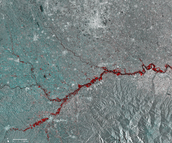 Image:
Torrential downpours have battered many parts of Italy this month, with extreme flooding wreaking havoc across northern Italy. The province of Alessandria is said to be one of the worst-affected areas according to Italian media, with around 200 people evacuated and 600 said to be left stranded.
This multi-temporal image uses two separate images captured by the Copernicus Sentinel-1 mission on 13 November and 25 November. The flooded areas can be seen depicted in red, the Po River in black, and urban areas in white.
Copernicus Sentinel-1’s radar ability to ‘see’ through clouds and rain, and in darkness, makes it particularly useful for monitoring floods. It can even easily differentiate water bodies, highlighting the difference between the Po River in black, and the extent of the flooding in red.
Around 500 people were evacuated further north in the Aosta Valley, where many roads were closed in fear of potential avalanches. Part of a viaduct serving the A6 motorway near Savona, in the northern region of Liguria, was washed away by a mudslide – leaving a 30 m gap in the road.
Images acquired before and after flooding offer immediate information on the extent of inundation and support assessments of property and environmental damage.
Earlier this month, the Copernicus Emergency Mapping Service was activated to help respond to the floods in northeast Italy, where Venice saw record-breaking water levels and the worst flooding in 50 years.