


![]()

zprávy
zdroje zpráv:WSDP - aktualizace dokumentace verze 2.8
18.10.2019 13:33 Dálkový přístup k údajům KN ČR Vážení uživatelé Webových služeb DP,upozorňujeme, že došlo k aktualizaci dokumentace pro Webové služby Dálkového přístupu (WSDP) v2.8. Aktuální verzi najdete na http://www.cuzk.cz/Katastr-nemovitosti/Poskytovani-udaju-z-KN/Dalkovy-pristup/Webove-sluzby-dalkoveho-pristupu.aspx. Instalace bude provedena při hlášené odstávce od 25.10.2019 do 28.20.2019.
Za komplikace tímto způsobené se omlouváme a děkujeme za pochopení.
MyGalileoApp enters the final stage
18.10.2019 11:28 European GNSS Agency
Final preparations are underway as the October 21 deadline approaches for the 10 finalists in this year’s MyGalileoApp competition to deliver a finalised version of their app. All the teams to successfully complete the second development phase will be invited to the award ceremony, to be held at the Prague headquarters of the European GNSS Agency (GSA) on 7 November 2019, where they will present their apps to a GSA evaluation board. To register to attend the event, click here.
The finalists will be welcomed to the awards ceremony by GSA Executive Director Carlo des Dorides and Matthias Petschke, Director of EU Satellite Navigation Programmes at the European Commission. Then, following an introduction by GSA Head of Market Development Fiammetta Diani and a keynote on “How to create a successful app” by Google Geospatial Technologist Ed Parsons, the finalists will make their pitches.
The pitches will be made in two stages, with five teams pitching first, followed by demonstrations of their apps and a speech by a MyGalileoApp mentor. Then the second five teams will pitch and demonstrate their projects. The awards will be decided after these pitches and the awards will be presented at a special ceremony to be held in the evening. Check out the agenda here.
Read this: GSA releases 6th GNSS Market Report
So, who are the finalists?
Of the 10 finalists, four are in the Augmented Reality and Games innovation area: uMaze (Finland) creates mazes in specific outdoor areas in which users can play; while ARGEO (Italy) allows users to discover content such as prizes, coupons and shopping cards geo-located around the streets of a city. The app from STPR (Poland, Australia, Ukraine) combines a virtual environment with game-related physical experiences in the real world, and arstory (Germany) is a complete augmented reality ecosystem based on Galileo location and virtual objects in the real world.
The Smart Navigation and Infotainment innovation area accounts for three of the 10 finalists. The Ready Park app (France) makes parking easier by pairing drivers leaving a spot with users looking for one. GALILEONAUT (France) is a mobile app that helps sailors to navigate inside a port or a marina and provides a link to the harbour master's office, while the Trukatu app (Spain) is a mobile C2C platform that connects people who want to rent or lease items with owners who have items to rent out.
Two of the shortlisted projects fall in the Fitness, Sport and mHealth category. The first of these - PanPan - Possible Assistance Needed (Germany) - serves as backup safety solution for potentially dangerous activities that may leave users in need of assistance, while the second - LetMeAut (Italy) - makes everyday tasks easier for people with autism.
Finally, the Mapping, GIS and Agriculture innovation area accounts for one app among the top 10 shortlisted projects. Tractor Navigator (France) provides guidance for farmers driving tractors, enabling them to visualise their current position and trajectory in an open field.
And this: Galileo and EGNOS featured at InterGEO 2019
Awards ceremony
Following the pitches, there will be an investors’ panel, with presentations by experts from various institutions, from the European Investment Bank to venture capital firms and accelerators, providing information on how apps can bridge the gap between great ideas and viable business opportunities. In general, there will be many business opportunities to explore from among the MyGalileoApp projects, so if you are an investor looking to invest in forward-looking GNSS-based applications register here to take advantage of this unparalleled networking opportunity.
Finally, after careful deliberation of the pitches and presentations made earlier, the GSA evaluation board will be ready to announce the winners and hand out the awards. The first-place winner will receive a EUR 100,000 prize. The runner up and third place winners will receive EUR 50,000 and EUR 30,000 respectively. The award ceremony will also include a speech by motivational speaker and explorer Johan Ernst Nilson.
Media note: This feature can be republished without charge provided the European GNSS Agency (GSA) is acknowledged as the source at the top or the bottom of the story. You must request permission before you use any of the photographs on the site. If you republish, we would be grateful if you could link back to the GSA website (http://www.gsa.europa.eu).
MyGalileoApp enters the final stage
18.10.2019 11:28 European GNSS AgencyFinal preparations are underway as the October 21 deadline approaches for the 10 finalists in this year’s MyGalileoApp competition to deliver a finalised version of their app. All the teams to successfully complete the second development phase will be invited to the award ceremony, to be held at the Prague headquarters of the European GNSS Agency (GSA) on 7 November 2019, where they will present their apps to a GSA evaluation board. To register to attend the event, click here.
The finalists will be welcomed to the awards ceremony by GSA Executive Director Carlo des Dorides and Matthias Petschke, Director of EU Satellite Navigation Programmes at the European Commission. Then, following an introduction by GSA Head of Market Development Fiammetta Diani and a keynote on “How to create a successful app” by Google Geospatial Technologist Ed Parsons, the finalists will make their pitches.
The pitches will be made in two stages, with five teams pitching first, followed by demonstrations of their apps and a speech by a MyGalileoApp mentor. Then the second five teams will pitch and demonstrate their projects. The awards will be decided after these pitches and the awards will be presented at a special ceremony to be held in the evening. Check out the agenda here.
Read this: GSA releases 6th GNSS Market Report
So, who are the finalists?
Of the 10 finalists, four are in the Augmented Reality and Games innovation area: uMaze (Finland) creates mazes in specific outdoor areas in which users can play; while ARGEO (Italy) allows users to discover content such as prizes, coupons and shopping cards geo-located around the streets of a city. The app from STPR (Poland, Australia, Ukraine) combines a virtual environment with game-related physical experiences in the real world, and arstory (Germany) is a complete augmented reality ecosystem based on Galileo location and virtual objects in the real world.
The Smart Navigation and Infotainment innovation area accounts for three of the 10 finalists. The Ready Park app (France) makes parking easier by pairing drivers leaving a spot with users looking for one. GALILEONAUT (France) is a mobile app that helps sailors to navigate inside a port or a marina and provides a link to the harbour master's office, while the Trukatu app (Spain) is a mobile C2C platform that connects people who want to rent or lease items with owners who have items to rent out.
Two of the shortlisted projects fall in the Fitness, Sport and mHealth category. The first of these - PanPan - Possible Assistance Needed (Germany) - serves as backup safety solution for potentially dangerous activities that may leave users in need of assistance, while the second - LetMeAut (Italy) - makes everyday tasks easier for people with autism.
Finally, the Mapping, GIS and Agriculture innovation area accounts for one app among the top 10 shortlisted projects. Tractor Navigator (France) provides guidance for farmers driving tractors, enabling them to visualise their current position and trajectory in an open field.
And this: Galileo and EGNOS featured at InterGEO 2019
Awards ceremony
Following the pitches, there will be an investors’ panel, with presentations by experts from various institutions, from the European Investment Bank to venture capital firms and accelerators, providing information on how apps can bridge the gap between great ideas and viable business opportunities. In general, there will be many business opportunities to explore from among the MyGalileoApp projects, so if you are an investor looking to invest in forward-looking GNSS-based applications register here to take advantage of this unparalleled networking opportunity.
Finally, after careful deliberation of the pitches and presentations made earlier, the GSA evaluation board will be ready to announce the winners and hand out the awards. The first-place winner will receive a EUR 100,000 prize. The runner up and third place winners will receive EUR 50,000 and EUR 30,000 respectively. The award ceremony will also include a speech by motivational speaker and explorer Johan Ernst Nilson.
Media note: This feature can be republished without charge provided the European GNSS Agency (GSA) is acknowledged as the source at the top or the bottom of the story. You must request permission before you use any of the photographs on the site. If you republish, we would be grateful if you could link back to the GSA website (http://www.gsa.europa.eu).
Korean Peninsula
18.10.2019 10:05 ESA Observing the Earth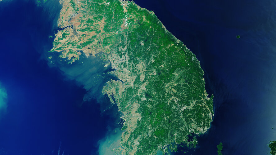
Earth observation image of the week: Copernicus Sentinel-3 takes us over the Korean Peninsula
Earth from Space
18.10.2019 10:05 ESA Observing the Earth
In this week's edition, discover the Korean Peninsula with Copernicus Sentinel-3
Earth from Space: Korean Peninsula
18.10.2019 10:00 ESA Observing the Earth Video:
00:02:23
Video:
00:02:23
In this week's edition of the Earth from Space programme, the Copernicus Sentinel-3 mission takes us over the Korean Peninsula in East Asia.
See also Korean Peninsula to download the image.
Earth from Space: Korean Peninsula
18.10.2019 10:00 ESA Observing the Earth
Video:
00:02:23
In this week's edition of the Earth from Space programme, the Copernicus Sentinel-3 mission takes us over the Korean Peninsula in East Asia.
See also Korean Peninsula to download the image.
Korean Peninsula
18.10.2019 10:00 ESA Observing the Earth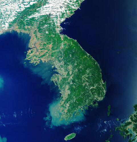 Image:
The Korean Peninsula in East Asia can be seen in this image captured by the Copernicus Sentinel-3 mission. The peninsula is over 900 km long and is located between the Sea of Japan, also known as the East Sea, to the east and the Yellow Sea to the west.
The peninsula is divided into two countries – the Democratic People's Republic of Korea (North Korea) and the Republic of Korea (South Korea).
North Korea is divided into nine provinces, with Pyongyang as the capital. Pyongyang, which can be seen in light grey in the upper left of the image, lies on the banks of the Taedong River and on a flat plain about 50 km inland from the Korea Bay.
The capital of South Korea is Seoul, which is in the northwest of the country, slightly inland and around 50 km south of the North Korean border.
As the image shows, the Korean peninsula is mostly mountainous and rocky, making less than 20% of the land suitable for farming.
The Yellow Sea owes its name to the silt-laden waters from the Chinese rivers that empty into it. It is also one of the largest shallow areas of continental shelf in the world with an average depth of around 50 m.
The waters off the coast of Korea are considered among the best in the world for fishing. The warm and cold currents attract a wide variety of species and the numerous islands, inlets and reefs provide excellent fishing grounds.
Sentinel-3 is a two-satellite mission to supply the coverage and data delivery needed for Europe’s Copernicus environmental monitoring programme. Each satellite’s instrument package includes an optical sensor to monitor changes in the colour of Earth’s surfaces. It can be used, for example, to monitor ocean biology and water quality.
This image, which was captured on 21 May 2019, is also featured on the Earth from Space video programme.
rada/odborný rada - právník
18.10.2019 9:42 ČÚZK - předpisy a opatření Český úřad zeměměřický a katastrální - Katastrální pracoviště Prahavypisuje výběrové řízení na místo
rada/odborný rada - právník
rada/odborný rada - právník
18.10.2019 9:42 ČÚZK - volná místa Český úřad zeměměřický a katastrální - Katastrální pracoviště Praha vypisuje výběrové řízení na místo rada/odborný rada - právníkreferent KN – návrh zápisu, kontrola a zplatnění do PO II.
18.10.2019 9:22 ČÚZK - volná místa Katastrální úřad pro hlavní město Prahu vypisuje výběrové řízení na místo referent KN – návrh zápisu, kontrola a zplatnění do PO II.referent KN – návrh zápisu, kontrola a zplatnění do PO II.
18.10.2019 9:22 ČÚZK /Urady/Katastralni-urady/Katastralni-urady/Katastralni-urad-pro-hlavni-mesto-Prahu/Uredni-deska/Oznameni-a-jina-uredni-sdeleni/Volna-mista/referent-KN-–-navrh-zapisu,-kontrola-a-zplatneni-dreferent KN – návrh zápisu, kontrola a zplatnění do PO II.
18.10.2019 9:22 ČÚZK - předpisy a opatření Katastrální úřad pro hlavní město Prahuvypisuje výběrové řízení na místo
referent KN – návrh zápisu, kontrola a zplatnění do PO II.
ArcGIS Online Transitions to Esri’s Next Generation JavaScript API (ArcNews Online)
18.10.2019 9:00 GISCafe.com Webcasts-Webinars20191018 Vrchní referent / rada oddělení dokumentace KN
18.10.2019 8:59 ČÚZK - předpisy a opatření Katastrální úřad pro Středočeský kraj - Katastrální pracoviště Kladno Vyhlášení výběrového řízení: Vrchní referent / rada oddělení dokumentace KN V části "Úřední deska", v sekci "Oznámení a jiná úřední sdělení" bylo vystaveno "Oznámení o vyhlášení výběrového řízení na obsazení služebního místa Vrchní referent / rada oddělení dokumentace KN"20191018 Vrchní referent / rada oddělení dokumentace KN
18.10.2019 8:59 ČÚZK /Urady/Katastralni-urady/Katastralni-urady/Katastralni-urad-pro-Stredocesky-kraj/Katastralni-pracoviste/KP-Kladno/O-uradu/Aktuality/20190828-Odborny-rada-oddeleni-pravnich-vztahu-(2)Vrchní referent / rada oddělení dokumentace KN
18.10.2019 8:58 ČÚZK /Urady/Katastralni-urady/Katastralni-urady/Katastralni-urad-pro-Stredocesky-kraj/Uredni-deska/Oznameni-a-jina-uredni-sdeleni/Volna-mista/Vrchni-referent-rada-oddeleni-dokumentace-KN-(1)Vrchní referent / rada oddělení dokumentace KN
18.10.2019 8:58 ČÚZK - předpisy a opatření Katastrální úřad pro Středočeský kraj - Katastrální pracoviště Kladnovypisuje výběrové řízení na místo Vrchní referent / rada oddělení dokumentace KN
Vrchní referent / rada oddělení dokumentace KN
Vrchní referent / rada oddělení dokumentace KN
18.10.2019 8:58 ČÚZK - volná místa Katastrální úřad pro Středočeský kraj - Katastrální pracoviště Kladno vypisuje výběrové řízení na místo Vrchní referent / rada oddělení dokumentace KNUPOZORNĚNÍ - omezení provozu
18.10.2019 6:13 ČÚZK /Urady/Katastralni-urady/Katastralni-urady/Katastralni-urad-pro-Plzensky-kraj/O-uradu/Aktuality/UPOZORNENI-omezeni-provozu-(1)UPOZORNĚNÍ - omezení provozu
18.10.2019 6:13 ČÚZK - předpisy a opatření Katastrální úřad pro Plzeňský kraj zveřejnil novou aktualitu: Dne 25. října 2019 nebude z technických důvodů možné správní poplatky za podané návrhy na vklad uhradit platebními kartami, tj. v tento den lze správní poplatky uhradit pouze hotovostně nebo kolkovými známkami, případně bezhotovostním příkazem na účet.Za případné komplikace spojené s tímto mimořádným omezením provozu se omlouváme a děkujeme za pochopení.
UPOZORNĚNÍ - omezení provozu
18.10.2019 6:10 ČÚZK /Urady/Katastralni-urady/Katastralni-urady/Katastralni-urad-pro-Plzensky-kraj/O-uradu/Aktuality/UPOZORNENI-omezeni-provozuUPOZORNĚNÍ - omezení provozu
18.10.2019 6:10 ČÚZK - předpisy a opatření Katastrální úřad pro Plzeňský kraj zveřejnil novou aktualitu: Dne 25. října 2019 nebudou z důvodu nezbytné provozní odstávky informačních systémů poskytovány údaje katastru nemovitostí, a to na žádném katastrálním pracovišti ani pobočce CzechPOINT.Za případné komplikace spojené s tímto mimořádným omezením provozu se omlouváme a děkujeme za pochopení.
2019 Commercial UAV Expo Americas to Break Exhibitor & Attendance Records
17.10.2019 23:01 GISCafe.com Webcasts-Webinars 200 + Exhibitors and 2,500+ drone professionals will come together Oct 28-30, 2019 in Las Vegas.LAS VEGAS, Oct. 17, 2019 — (PRNewswire) …
Blue Marble attends Surveying, Mapping, and Geoinformation Technology Equipment Expo in Nanjing, China
17.10.2019 23:01 GISCafe.com Webcasts-Webinars While in Nanjing, China for the Surveying, Mapping, and Geoinformation Technology Equipment Expo, Blue Marble conducted a one-day LiDAR workshop in …Textron Reports Third Quarter 2019 Results
17.10.2019 18:51 GISCafe.com Webcasts-Webinars EPS of $0.95, up 56% from adjusted EPS a year agoOperating margin of 9.1%, up from 7.7% a year ago
$109 million returned to shareholders through …
MetLife Stadium Selects AeroDefense for Drone Detection
17.10.2019 18:51 GISCafe.com Webcasts-Webinars Technology Alerts Stadium Security of Drone and Controller for Quick Response, Threat Mitigation, and Guest SafetyHOLMDEL, N.J. — (BUSINESS …
Brněnská Geopárty přivítá nové prváky oboru geodézie
17.10.2019 17:47 ZeměměřičIniciace studentů prvního ročníku oboru geodézie a kartografie na brněnském VUT se letos bude konat 4. listopadu 2019 v Kulturním centru Omega (Musilka). Pro loňskou událost studenti vybrali téma první republiky, letošním tématem je tentokrát „za katrem„. Pořadatelé zvou: Rok se s rokem sešel a už tu máme zase naší oblíbenou GEOPÁRTY letos s vězeňskou tématikou. Takže konečně si můžete vzít […]
The post Brněnská Geopárty přivítá nové prváky oboru geodézie appeared first on Zeměměřič.
Nedostupnost informačních systémů
17.10.2019 16:31 ČÚZK /Zememerictvi/Zememericke-cinnosti/Aktuality-pro-zememerice/Nedostupnost-informacnich-systemuNedostupnost informačních systémů
17.10.2019 16:31 ČÚZK - RSS kanál pro zeměměřiče Upozorňujeme, že od pátku 25.10.2019 od 8:15 hodin do pondělí 28.10.2019 cca 12:00 hodin nebudou z provozních důvodů dostupné Webové služby pro vyhotovitele a ověřovatele geometrických plánů, z Nahlížení do KN nebude dostupné poskytování ZPMZ v elektronické podobě, nebudou dostupné ani žádné služby Dálkového přístupu do KN. Provozní odstávka informačních systémů se týká i katastrálních pracovišť.Počítejte prosím s tímto omezením při přípravě podkladů pro měření. Omlouváme se za komplikace a děkujeme za pochopení.
Nedostupnost informačních systémů
17.10.2019 16:31 ČÚZK /Zememerictvi/Zememericke-cinnosti/Aktuality-pro-zememerice/2019/Nedostupnost-informacnich-systemuNedostupnost informačních systémů
17.10.2019 16:31 ČÚZK - RSS kanál pro zeměměřiče Upozorňujeme, že od pátku 25.10.2019 od 8:15 hodin do pondělí 28.10.2019 cca 12:00 hodin nebudou z provozních důvodů dostupné Webové služby pro vyhotovitele a ověřovatele geometrických plánů, z Nahlížení do KN nebude dostupné poskytování ZPMZ v elektronické podobě, nebudou dostupné ani žádné služby Dálkového přístupu do KN. Provozní odstávka informačních systémů se týká i katastrálních pracovišť.Počítejte prosím s tímto omezením při přípravě podkladů pro měření. Omlouváme se za komplikace a děkujeme za pochopení.
Nedostupnost informačních systémů
17.10.2019 16:31 ČÚZK - předpisy a opatření Český úřad zeměměřický a katastrální zveřejnil novou aktualitu: Upozorňujeme, že od pátku 25.10.2019 od 8:15 hodin do pondělí 28.10.2019 cca 12:00 hodin nebudou z provozních důvodů dostupné Webové služby pro vyhotovitele a ověřovatele geometrických plánů, z Nahlížení do KN nebude dostupné poskytování ZPMZ v elektronické podobě, nebudou dostupné ani žádné služby Dálkového přístupu do KN. Provozní odstávka informačních systémů se týká i katastrálních pracovišť.Počítejte prosím s tímto omezením při přípravě podkladů pro měření. Omlouváme se za komplikace a děkujeme za pochopení.
Informace o omezení provozu 25. řijna 2019
17.10.2019 16:12 ČÚZK /Urady/Katastralni-urady/Katastralni-urady/Katastralni-urad-pro-Zlinsky-kraj/O-uradu/Aktuality/Informace-o-omezeni-provozu-25-rijna-2019Informace o omezení provozu 25. řijna 2019
17.10.2019 16:12 ČÚZK - předpisy a opatření Katastrální úřad pro Zlínský kraj zveřejnil novou aktualitu:Za případné komplikace spojené s tímto mimořádným omezením provozu se omlouváme a děkujeme za pochopení.
Ing. Štěpán Forman
ředitel Katastrálního úřadu pro Zlínský kraj
Omezení provozu 25. října 2019
17.10.2019 14:20 ČÚZK /Urady/Katastralni-urady/Katastralni-urady/Katastralni-urad-pro-Kralovehradecky-kraj/O-uradu/Aktuality/Omezeni-provozu-25-rijna-2019Omezení provozu 25. října 2019
17.10.2019 14:20 ČÚZK - předpisy a opatření Katastrální úřad pro Královéhradecký kraj zveřejnil novou aktualitu: Omezení provozu25. října 2019
Omezení provozu 25. října 2019
17.10.2019 14:20 ČÚZK - předpisy a opatření Katastrální úřad pro Královéhradecký kraj zveřejnil novou aktualitu: Upozornění - Odstávka informačního systému katastru nemovitostí 25. října 2019"2019 Wildfire Risk Report from CoreLogic Analyzes Western U.S. Damage and Risk" by Susan Smith
17.10.2019 14:15 GISCafe.com Webcasts-Webinars20191017-Provozní odstávka informačních systémů
17.10.2019 14:03 ČÚZK /Aktuality-resort/2019/20191017-Provozni-odstavka-informacnich-systemu20191017-Provozní odstávka informačních systémů
17.10.2019 14:03 ČÚZK - předpisy a opatření Český úřad zeměměřický a katastrální zveřejnil novou aktualitu: Dne 25. října 2019 nebudou z důvodu nezbytné provozní odstávky informačních systémů poskytovány údaje katastru nemovitostí, a to na žádném katastrálním pracovišti ani pobočce CzechPOINT.Za případné komplikace spojené s tímto mimořádným omezením provozu se omlouváme a děkujeme za pochopení.
Plánovaná odstávka služieb ESKN a ZBGIS
17.10.2019 14:00
ÚGKK SR
V dňoch od 18.10.2019 (od 15:00 hod.) do 19.10.2019 bude vykonaná plánovaná technická údržba (servisný zásah) IT infraštruktúry rezortu ÚGKK SR. V uvedenom čase nebudú dostupné služby systémov ESKN, ZBGIS, Obchodného modulu a ISGZ.
Za vzniknuté problémy sa vopred ospravedlňujeme.
20191017 - omezení chodu úřadu
17.10.2019 13:38 ČÚZK - předpisy a opatření Katastrální úřad pro Karlovarský kraj - Katastrální pracoviště Cheb zveřejnil novou aktualitu: Dne 25. října 2019 nebudou z důvodu nezbytné provozní odstávky informačních systémů poskytovány údaje katastru nemovitostí, a to na žádném katastrálním pracovišti ani pobočce Czech POINT.Za případné komplikace spojené s tímto mimořádným omezením provozu se omlouváme a děkujeme za pochopení.
20191017 - omezení chodu úřadu
17.10.2019 13:38 ČÚZK /Urady/Katastralni-urady/Katastralni-urady/Katastralni-urad-pro-Karlovarsky-kraj/Katastralni-pracoviste/KP-Cheb/O-uradu/Aktuality/20191017-omezeni-chodu-uradu20191017 - omezení chodu úřadu
17.10.2019 13:37 ČÚZK /Urady/Katastralni-urady/Katastralni-urady/Katastralni-urad-pro-Karlovarsky-kraj/Katastralni-pracoviste/KP-Karlovy-Vary/O-uradu/Aktuality/20191017-omezeni-chodu-uradu20191017 - omezení chodu úřadu
17.10.2019 13:37 ČÚZK - předpisy a opatření Katastrální úřad pro Karlovarský kraj - Katastrální pracoviště Karlovy Vary zveřejnil novou aktualitu: Dne 25. října 2019 nebudou z důvodu nezbytné provozní odstávky informačních systémů poskytovány údaje katastru nemovitostí, a to na žádném katastrálním pracovišti ani pobočce Czech POINT.Za případné komplikace spojené s tímto mimořádným omezením provozu se omlouváme a děkujeme za pochopení.
Ing. Libor Tomandl, ředitel KP Karlovy Vary
20191017 - omezení chodu úřadu
17.10.2019 13:34 ČÚZK /Urady/Katastralni-urady/Katastralni-urady/Katastralni-urad-pro-Karlovarsky-kraj/O-uradu/Aktuality/20191017-omezeni-chodu-uradu20191017 - omezení chodu úřadu
17.10.2019 13:34 ČÚZK - předpisy a opatření Katastrální úřad pro Karlovarský kraj zveřejnil novou aktualitu: Dne 25. října 2019 nebudou z důvodu nezbytné provozní odstávky informačních systémů poskytovány údaje katastru nemovitostí, a to na žádném katastrálním pracovišti ani pobočce Czech POINT.Za případné komplikace spojené s tímto mimořádným omezením provozu se omlouváme a děkujeme za pochopení.
GNSS Market Report downloaded 1,000 times in first 24 hours
17.10.2019 12:55 European GNSS Agency
The sixth issue of the GNSS Market Report from the European GNSS Agency (GSA) has been downloaded over 1,000 times since it was published on the GSA website on October 15. With its comprehensive overview of the current status and future trends on the global GNSS market, the report was eagerly awaited by all market players, from global corporations and SMEs to R&D organisations and academia.
Regularly referenced by policy-makers and business leaders around the world, the GNSS Market Report serves as the go-to resource for anybody requiring an in-depth look at GNSS market opportunities and trends across key market segments. The previous issue of the Market Report has been downloaded over 60,000 times since it was published in 2017.
Read this: GSA releases 6th GNSS Market Report
“Given the dynamism of the GNSS market, we anticipated that there would be high demand for the latest issue of the GNSS Market Report with its valuable insights and forecasts. The number of downloads in the first day of publication is a clear indicator of how highly it is valued as a resource by all stakeholders in the GNSS ecosystem,” said GSA Head of Market Development Fiammetta Diani.
To read the report in full, download it for free here.
The structure of this year’s report has changed slightly compared to previous years and the number of GNSS market segments reviewed has increased to 10, to better reflect the situation on the market and to enable more specific and accurate findings. The market segments in this year’s report are: Consumer Solutions, Road, Manned Aviation, Drones, Maritime, Emergency Response, Rail, Agriculture, Geomatics and Critical Infrastructure.
GSA Reports
The GNSS Market Report is one of a series of intelligence reports produced by the GSA. It is published every two years. The Market Report alternates with the GNSS User Technology Report, which takes an in-depth look at the state-of-the-art in GNSS receiver technology and provides expert analysis on the evolutionary trends that are set to define the dynamic global GNSS user technology industry.
Other reports produced by the GSA include Reports on User Needs and Requirements for Position, Navigation and Time, which are the outcome of the European GNSS User Consultation Platform – the next meeting of which will take place at European Space Week in December. These reports provide an overview of GNSS trends across a broad range of applications, along with in-depth analysis of user needs and requirements applicable to specific market segments.
For a full list of GSA publications, click here.
Media note: This feature can be republished without charge provided the European GNSS Agency (GSA) is acknowledged as the source at the top or the bottom of the story. You must request permission before you use any of the photographs on the site. If you republish, we would be grateful if you could link back to the GSA website (http://www.gsa.europa.eu).
GNSS Market Report downloaded 1,000 times in first 24 hours
17.10.2019 12:55 European GNSS AgencyThe sixth issue of the GNSS Market Report from the European GNSS Agency (GSA) has been downloaded over 1,000 times since it was published on the GSA website on October 15. With its comprehensive overview of the current status and future trends on the global GNSS market, the report was eagerly awaited by all market players, from global corporations and SMEs to R&D organisations and academia.
Regularly referenced by policy-makers and business leaders around the world, the GNSS Market Report serves as the go-to resource for anybody requiring an in-depth look at GNSS market opportunities and trends across key market segments. The previous issue of the Market Report has been downloaded over 60,000 times since it was published in 2017.
Read this: GSA releases 6th GNSS Market Report
“Given the dynamism of the GNSS market, we anticipated that there would be high demand for the latest issue of the GNSS Market Report with its valuable insights and forecasts. The number of downloads in the first day of publication is a clear indicator of how highly it is valued as a resource by all stakeholders in the GNSS ecosystem,” said GSA Head of Market Development Fiammetta Diani.
To read the report in full, download it for free here.
The structure of this year’s report has changed slightly compared to previous years and the number of GNSS market segments reviewed has increased to 10, to better reflect the situation on the market and to enable more specific and accurate findings. The market segments in this year’s report are: Consumer Solutions, Road, Manned Aviation, Drones, Maritime, Emergency Response, Rail, Agriculture, Geomatics and Critical Infrastructure.
GSA Reports
The GNSS Market Report is one of a series of intelligence reports produced by the GSA. It is published every two years. The Market Report alternates with the GNSS User Technology Report, which takes an in-depth look at the state-of-the-art in GNSS receiver technology and provides expert analysis on the evolutionary trends that are set to define the dynamic global GNSS user technology industry.
Other reports produced by the GSA include Reports on User Needs and Requirements for Position, Navigation and Time, which are the outcome of the European GNSS User Consultation Platform – the next meeting of which will take place at European Space Week in December. These reports provide an overview of GNSS trends across a broad range of applications, along with in-depth analysis of user needs and requirements applicable to specific market segments.
For a full list of GSA publications, click here.
Media note: This feature can be republished without charge provided the European GNSS Agency (GSA) is acknowledged as the source at the top or the bottom of the story. You must request permission before you use any of the photographs on the site. If you republish, we would be grateful if you could link back to the GSA website (http://www.gsa.europa.eu).
Nové verze před Setkáním G&A 2019
17.10.2019 11:04 GEPROZveřejnili jsme verze 14.33 našich produktů MISYS, MISYS-WEB – licenční server, KOKEŠ, Geoportál GEPRO a PROLAND.… >>
Omezení provozu
17.10.2019 10:47 ČÚZK - předpisy a opatření Katastrální úřad pro Moravskoslezský kraj - Katastrální pracoviště Třinec zveřejnil novou aktualitu: V pátek 25. října 2019 nebudou z důvodu nezbytné provozní odstávky informačních systémů poskytovány údaje katastru nemovitostí, a to na žádném katastrálním pracovišti ani pobočce CzechPOINT.Podatelny katastrálních pracovišť budou přijímat pouze písemná podání a žádosti. Ze stejného důvodu také nelze pro platbu správních poplatků využít platební kartu.
Omlouváme se všem klientům za případné komplikace spojené s tímto mimořádným omezením provozu a děkujeme za pochopení.
Omezení provozu
17.10.2019 10:47 ČÚZK /Urady/Katastralni-urady/Katastralni-urady/Katastralni-urad-pro-Moravskoslezsky-kraj/Katastralni-pracoviste/KP-Trinec/O-uradu/Aktuality/Omezeni-provozuOmezení provozu
17.10.2019 10:46 ČÚZK - předpisy a opatření Katastrální úřad pro Moravskoslezský kraj - Katastrální pracoviště Opava zveřejnil novou aktualitu: V pátek 25. října 2019 nebudou z důvodu nezbytné provozní odstávky informačních systémů poskytovány údaje katastru nemovitostí, a to na žádném katastrálním pracovišti ani pobočce CzechPOINT.Podatelny katastrálních pracovišť budou přijímat pouze písemná podání a žádosti. Ze stejného důvodu také nelze pro platbu správních poplatků využít platební kartu.
Omlouváme se všem klientům za případné komplikace spojené s tímto mimořádným omezením provozu a děkujeme za pochopení.
Omezení provozu
17.10.2019 10:46 ČÚZK /Urady/Katastralni-urady/Katastralni-urady/Katastralni-urad-pro-Moravskoslezsky-kraj/Katastralni-pracoviste/KP-Opava/O-uradu/Aktuality/Omezeni-provozuOmezení provozu
17.10.2019 10:45 ČÚZK - předpisy a opatření Katastrální úřad pro Moravskoslezský kraj - Katastrální pracoviště Nový Jičín zveřejnil novou aktualitu: V pátek 25. října 2019 nebudou z důvodu nezbytné provozní odstávky informačních systémů poskytovány údaje katastru nemovitostí, a to na žádném katastrálním pracovišti ani pobočce CzechPOINT.Podatelny katastrálních pracovišť budou přijímat pouze písemná podání a žádosti. Ze stejného důvodu také nelze pro platbu správních poplatků využít platební kartu.
Omlouváme se všem klientům za případné komplikace spojené s tímto mimořádným omezením provozu a děkujeme za pochopení.
Omezení provozu
17.10.2019 10:45 ČÚZK /Urady/Katastralni-urady/Katastralni-urady/Katastralni-urad-pro-Moravskoslezsky-kraj/Katastralni-pracoviste/KP-Novy-Jicin/O-uradu/Aktuality/Omezeni-provozuOmezení provozu
17.10.2019 10:45 ČÚZK /Urady/Katastralni-urady/Katastralni-urady/Katastralni-urad-pro-Moravskoslezsky-kraj/Katastralni-pracoviste/KP-Krnov/O-uradu/Aktuality/Omezeni-provozuOmezení provozu
17.10.2019 10:45 ČÚZK - předpisy a opatření Katastrální úřad pro Moravskoslezský kraj - Katastrální pracoviště Krnov zveřejnil novou aktualitu: V pátek 25. října 2019 nebudou z důvodu nezbytné provozní odstávky informačních systémů poskytovány údaje katastru nemovitostí, a to na žádném katastrálním pracovišti ani pobočce CzechPOINT.Podatelny katastrálních pracovišť budou přijímat pouze písemná podání a žádosti. Ze stejného důvodu také nelze pro platbu správních poplatků využít platební kartu.
Omlouváme se všem klientům za případné komplikace spojené s tímto mimořádným omezením provozu a děkujeme za pochopení.
Omezení provozu
17.10.2019 10:43 ČÚZK - předpisy a opatření Katastrální úřad pro Moravskoslezský kraj - Katastrální pracoviště Frýdek-Místek zveřejnil novou aktualitu: V pátek 25. října 2019 nebudou z důvodu nezbytné provozní odstávky informačních systémů poskytovány údaje katastru nemovitostí, a to na žádném katastrálním pracovišti ani pobočce CzechPOINT.Podatelny katastrálních pracovišť budou přijímat pouze písemná podání a žádosti. Ze stejného důvodu také nelze pro platbu správních poplatků využít platební kartu.
Omlouváme se všem klientům za případné komplikace spojené s tímto mimořádným omezením provozu a děkujeme za pochopení.
Omezení provozu
17.10.2019 10:43 ČÚZK /Urady/Katastralni-urady/Katastralni-urady/Katastralni-urad-pro-Moravskoslezsky-kraj/Katastralni-pracoviste/KP-Frydek-Mistek/O-uradu/Aktuality/Omezeni-provozuOmezení provozu
17.10.2019 10:42 ČÚZK - předpisy a opatření Katastrální úřad pro Moravskoslezský kraj - Katastrální pracoviště Bruntál zveřejnil novou aktualitu: V pátek 25. října 2019 nebudou z důvodu nezbytné provozní odstávky informačních systémů poskytovány údaje katastru nemovitostí, a to na žádném katastrálním pracovišti ani pobočce CzechPOINT.Podatelny katastrálních pracovišť budou přijímat pouze písemná podání a žádosti. Ze stejného důvodu také nelze pro platbu správních poplatků využít platební kartu.
Omlouváme se všem klientům za případné komplikace spojené s tímto mimořádným omezením provozu a děkujeme za pochopení.
Omezení provozu
17.10.2019 10:42 ČÚZK /Urady/Katastralni-urady/Katastralni-urady/Katastralni-urad-pro-Moravskoslezsky-kraj/Katastralni-pracoviste/KP-Bruntal/O-uradu/Aktuality/Omezeni-provozuDružice Quantum odolala extrémním teplotám
17.10.2019 10:37 Český Kosmický PortálDružice Quantum - evropský přeprogramovatelný telekomunikační satelit - vznikající v rámci programu ESA Partnership Project ve spolupráci s operátorem Eutelsat, úspěšně dokončila 28. září teplotně-vakuové testy.
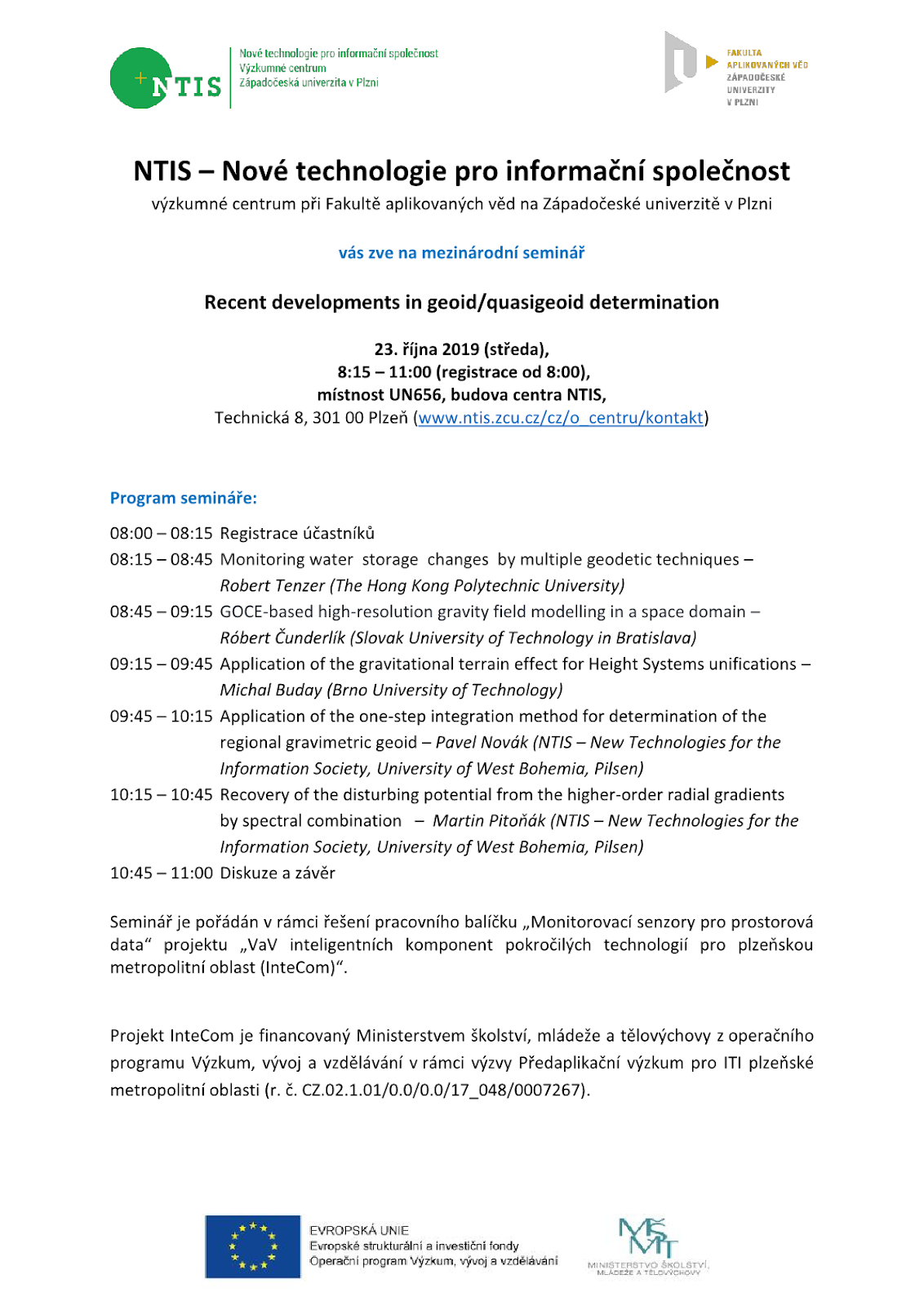
Zveme Vás na mezinárodní workshop "Recent developments in geoid/quasigeoid determination"
17.10.2019 10:37 Blogující geomatici - FAV ZČU Mezinárodní workshop na téma "Recent developments in geoid/quasigeoid determination" se uskuteční 23. října 2019, v čase 8:15 – 11:00 (registrace účastníků od 8:00) v místnosti UN656 (budova centra NTIS).Více informací o programu workshopu najdete na přiložené pozvánce.
Ice shelf Getz smaller
17.10.2019 10:36 ESA Observing the Earth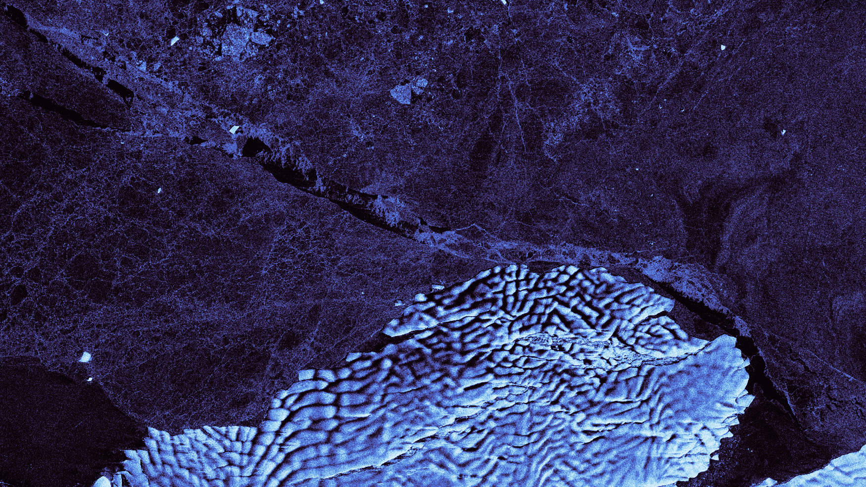
Using images from the Copernicus Sentinel-1 mission, this animation shows the B47 iceberg breaking off from the Getz Ice Shelf in West Antarctica
20191017 Odborný referent / vrchní referent oddělení obnovy a revize KN
17.10.2019 10:27 ČÚZK - předpisy a opatření Katastrální úřad pro Středočeský kraj - Katastrální pracoviště Praha-západ Vyhlášení výběrového řízení: Odborný referent / vrchní referent oddělení obnovy a revize KN V části "Úřední deska", v sekci "Oznámení a jiná úřední sdělení" bylo vystaveno "Oznámení o vyhlášení výběrového řízení na obsazení služebního místa Odborný referent / vrchní referent oddělení obnovy a revize KN"20191017 Odborný referent / vrchní referent oddělení obnovy a revize KN
17.10.2019 10:27 ČÚZK /Urady/Katastralni-urady/Katastralni-urady/Katastralni-urad-pro-Stredocesky-kraj/Katastralni-pracoviste/KP-Praha-zapad/O-uradu/Aktuality/20190923-Rada-odborny-rada-oddeleni-aktualizac-(1)Odborný referent / vrchní referent oddělení obnovy a revize KN
17.10.2019 10:27 ČÚZK /Urady/Katastralni-urady/Katastralni-urady/Katastralni-urad-pro-Stredocesky-kraj/Uredni-deska/Oznameni-a-jina-uredni-sdeleni/Volna-mista/Odborny-referent-vrchni-referent-oddeleni-obnovyOdborný referent / vrchní referent oddělení obnovy a revize KN
17.10.2019 10:27 ČÚZK - předpisy a opatření Katastrální úřad pro Středočeský kraj - Katastrální pracoviště Praha-západvypisuje výběrové řízení na místo Odborný referent / vrchní referent oddělení obnovy a revize KN
Odborný referent / vrchní referent oddělení obnovy a revize KN
Odborný referent / vrchní referent oddělení obnovy a revize KN
17.10.2019 10:27 ČÚZK - volná místa Katastrální úřad pro Středočeský kraj - Katastrální pracoviště Praha-západ vypisuje výběrové řízení na místo Odborný referent / vrchní referent oddělení obnovy a revize KNB47 breaks off Getz Ice Shelf
17.10.2019 10:26 ESA Observing the Earth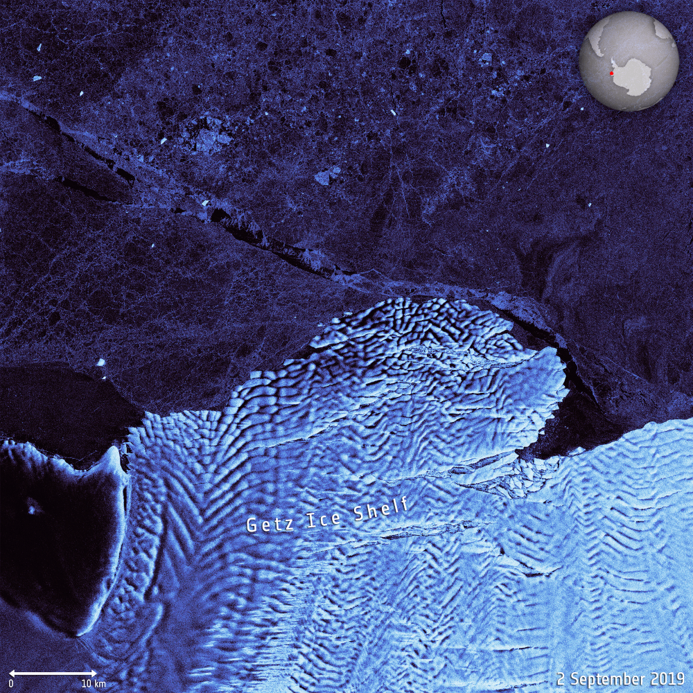 Image:
A large iceberg, approximately 260 sq km, recently calved from the Getz Ice Shelf in West Antarctica. Using images from the Copernicus Sentinel-1 mission from 2 September to 14 October 2019, this animation shows the berg breaking off before spinning around in the Amundsen Sea.
The iceberg is approximately 35 km in length, and 10 km wide. Named B47 by the US National Ice Center (NIC), the iceberg was first discovered and confirmed using Copernicus Sentinel-1 imagery by an analyst from the US NIC.
The Copernicus Sentinel-1 mission carries radar, which can return images regardless of day or night and this allows us year-round viewing, which is especially important through the long, dark, austral winter months.
Modeling the Flow of Dangerous Goods by Rail (ArcUser Online)
17.10.2019 9:00 GISCafe.com Webcasts-WebinarsOdstávka IS KN
17.10.2019 8:59 ČÚZK /Urady/Katastralni-urady/Katastralni-urady/Katastralni-urad-pro-Olomoucky-kraj/O-uradu/Aktuality/Odstavka-IS-KNOdstávka IS KN
17.10.2019 8:59 ČÚZK - předpisy a opatření Katastrální úřad pro Olomoucký kraj zveřejnil novou aktualitu: ODSTÁVKA INFORMAČNÍHO SYSTÉMU KATASTRU NEMOVITOSTÍDne 25. října 2019 nebudou z důvodu nezbytné provozní odstávky informačních systémů poskytovány údaje katastru nemovitostí, a to na žádném katastrálním pracovišti ani pobočce CzechPOINT.
Za případné komplikace spojené s tímto mimořádným omezením provozu se omlouváme a děkujeme za pochopení.
Ing. Daniel Janošík, ředitel Katastrálního úřadu pro Olomoucký kraj
Omezení provozu
17.10.2019 8:15 ČÚZK - předpisy a opatření Katastrální úřad pro Moravskoslezský kraj - Katastrální pracoviště Ostrava zveřejnil novou aktualitu: V pátek 25. října 2019 nebudou z důvodu nezbytné provozní odstávky informačních systémů poskytovány údaje katastru nemovitostí, a to na žádném katastrálním pracovišti ani pobočce CzechPOINT.Podatelny katastrálních pracovišť budou přijímat pouze písemná podání a žádosti. Ze stejného důvodu také nelze pro platbu správních poplatků využít platební kartu.
Omlouváme se všem klientům za případné komplikace spojené s tímto mimořádným omezením provozu a děkujeme za pochopení.
Omezení provozu
17.10.2019 8:15 ČÚZK /Urady/Katastralni-urady/Katastralni-urady/Katastralni-urad-pro-Moravskoslezsky-kraj/Katastralni-pracoviste/KP-Ostrava/O-uradu/Aktuality/Omezeni-provozuBudoucnost naší krajiny – seminář v Poslanecké sněmovně
17.10.2019 7:14 Asociace podnikatelů v geomatice Pozvánka a program semináře zde APG dne 30. října 2019 pořádá v Poslanecké sněmovně seminář nazvaný Budoucnost naší krajiny: Co ještě nevíte o pozemkových úpravách?. APG se podařilo získat nad touto akcí záštitu zemědělského výboru PS PČR. Na semináři vystoupí se svou přednáškou prof. Ing. Miroslav Dumbrovský, CSc. z brněnské VUT, RNDr. Petr Kubala, generální ředitel Povodí Vltavy a další odborníci […]Omezení provozu
17.10.2019 7:10 ČÚZK - předpisy a opatření Český úřad zeměměřický a katastrální - Katastrální pracoviště Karviná zveřejnil novou aktualitu: Dne 25. října 2019 nebudou z důvodu nezbytné provozní odstávky informačních systémů poskytovány údaje katastru nemovitostí, a to na žádném katastrálním pracovišti ani pobočce CzechPOINT.Za případné komplikace spojené s tímto mimořádným omezení provozu se omlouváme a děkujeme za pochopení.
v z. Bc. Zuzana Bouzková
vedoucí oddělení právních vztahů k nemovitostem
Ing. Hana Pijáková
ředitelka katastrálního pracoviště
Omezení provozu
17.10.2019 7:10 ČÚZK - předpisy a opatření Český úřad zeměměřický a katastrální - Katastrální pracoviště Karviná zveřejnil novou aktualitu: Dne 25. října 2019 nebudou z důvodu nezbytné provozní odstávky informačních systémů poskytovány údaje katastru nemovitostí, a to na žádném katastrálním pracovišti ani pobočce CzechPOINT.Za případné komplikace spojené s tímto mimořádným omezení provozu se omlouváme a děkujeme za pochopení.
Omezení provozu
17.10.2019 7:10 ČÚZK - předpisy a opatření Katastrální úřad pro Moravskoslezský kraj - Katastrální pracoviště Karviná zveřejnil novou aktualitu: V pátek 25. října 2019 nebudou z důvodu nezbytné provozní odstávky informačních systémů poskytovány údaje katastru nemovitostí, a to na žádném katastrálním pracovišti ani pobočce CzechPOINT.Podatelny katastrálních pracovišť budou přijímat pouze písemná podání a žádosti. Ze stejného důvodu také nelze pro platbu správních poplatků využít platební kartu.
Omlouváme se všem klientům za případné komplikace spojené s tímto mimořádným omezením provozu a děkujeme za pochopení.
Omezení provozu
17.10.2019 7:10 ČÚZK /Urady/Katastralni-urady/Katastralni-urady/Katastralni-urad-pro-Moravskoslezsky-kraj/Katastralni-pracoviste/KP-Karvina/O-uradu/Aktuality/Omezeni-provozuOmezení provozu
17.10.2019 7:10 ČÚZK - předpisy a opatření Katastrální úřad pro Moravskoslezský kraj - Katastrální pracoviště Karviná zveřejnil novou aktualitu: Dne 25. října 2019 nebudou z důvodu nezbytné provozní odstávky informačních systémů poskytovány údaje katastru nemovitostí, a to na žádném katastrálním pracovišti ani pobočce CzechPOINT.Za případné komplikace spojené s tímto mimořádným omezení provozu se omlouváme a děkujeme za pochopení.
APGEO - BUDOUCNOST NAŠÍ KRAJINY – SEMINÁŘ V POSLANECKÉ SNĚMOVNĚ
17.10.2019 2:00 Asociace podnikatelů v geomatice APG dne 30. října 2019 pořádá v Poslanecké sněmovně seminář nazvaný Budoucnost naší krajiny: Co ještě nevíte o ...Datumate Strengthens Its Presence in the UK Striking a Strategic Partnership With Pell Frischmann
16.10.2019 23:39 GISCafe.com Webcasts-Webinars YOKNEAM, Israel, and LONDON, Oct. 16, 2019 — (PRNewswire) — Datumate and Pell Frischmann are pleased to announce today that they have …GIC Collects Post-Disaster Imagery over Saddleridge Fire
16.10.2019 23:38 GISCafe.com Webcasts-Webinars Images available to emergency personnel, GIC member insurers, and the mediaDES PLAINES, Ill., Oct. 16, 2019 — (PRNewswire) —
DES …
Dresdner Robin Maps Home of Future Jersey City Whole Foods Market
16.10.2019 23:38 GISCafe.com Webcasts-Webinars Land-use consultancy Dresdner Robin partners with HLW to scan two levels of Mack-Cali-owned parking garage that will be reconfigured to house leading …Sanborn Announces Expansion of Sanborn GeoServe™ SaaS Solutions
16.10.2019 23:38 GISCafe.com Webcasts-Webinars COLORADO SPRINGS, Colo. — (BUSINESS WIRE) — October 16, 2019 —Sanborn is announcing expansion of its Software-as-a-Service (SaaS) …
Ibeo Automotive USA to discuss next-generation solid state LiDAR for future autonomous driving
16.10.2019 23:38 GISCafe.com Webcasts-Webinars DETROIT, Oct. 16, 2019 — (PRNewswire) — Paula Jones, president of Ibeo Automotive USA – a subsidiary of the Hamburg, Germany-based …Konference o managementu
16.10.2019 22:39 Asociace podnikatelů v geomatice Dne 7. listopadu 2019 se v brněnském hotelu Marriott uskuteční konference o managementu. Organizátoři v pozvánce říkají, že vám poradí, jak správně vést lidi, celý podnik či váš byznys. Pro konferenci zvolili výrok „Ryba smrdí od hlavy“, jelikož úspěch firmy závisí právě na jejím správném řízení – hlavě. Na celodenní konferenci vystoupí několik řečníků, kteří předají své rady a tipy […]Předseda APG přednášel na Technologickém fóru
16.10.2019 22:37 Asociace podnikatelů v geomatice V rámci 25. ročníku mezinárodního stavebního veletrhu FOR ARCH se letos potřetí konalo Technologické fórum – jednodenní diskuzní setkání k aktuálním tématům ze stavebnictví. Letos byla konference věnována digitalizaci stavebnictví a stavebního práva. Na konferenci rovněž vystoupil předseda APG Martin Hrdlička s referátem Garantovaná data – základ digitalizace, ve kterém představil činnost APG a důležitost geomatiky pro stavebnictví.Seminář APG pro Svaz podnikatelů ve stavebnictví
16.10.2019 22:32 Asociace podnikatelů v geomatice APG uspořádala pro Svaz podnikatelů ve stavebnictví odborný seminář, na kterém Ing. Petr Pracný ze společnosti GEFOS a Ing. Zbyněk Kugler ze společnosti GRID představili možnosti současné geomatiky. Oba referáty se setkaly s velmi pozitivní odezvou všech přítomných včetně technického ředitele SPS Ing. Pavla Ševčíka. První přednáška Petra Pracného byla zaměřena na možnosti řízení stavebních strojů s pomocí […]GeoTalks 01 – Jaroslav Burian
16.10.2019 20:00 Katedra geoinformatiky UP OlomoucPrvní díl nového podcastu GeoTalks. Geoinformatika má strašně velké množství přesahů. Běžná práce geoinformatika může jeden den znamenat spolupráci v oblasti sportu, druhý den spolupráci s psychologem, třetí den řešíte povodně a čtvrtý den dopravní témata. Takhle shrnuje svou práci Jarda Burian, host úvodní epizody našeho podcastu.
The post GeoTalks 01 – Jaroslav Burian appeared first on Katedra geoinformatiky.
2019 Commercial UAV Expo Americas to Break Exhibitor & Attendance Records
16.10.2019 19:30 GISCafe.com Webcasts-Webinars 200 + Exhibitors and 2,500+ drone professionals will come together Oct 28-30, 2019 in Las Vegas2019 Commercial UAV Expo Americas to Break Exhibitor …
Fotografie z komentované prohlídky výstavy Pavel Aretin z Ehrenfeldu: mapa mezi defenestrací a Bílou horou [Knihovna geografie, byTopic]
16.10.2019 17:45 Katedra aplikované geoinformatiky a kartografie Přf UK Komentovaná prohlídka se uskutečnila 26. 6. 2018 od 14 hodin. Výstavou, umístěnou v předsálí Mapové sbírky (Albertov 6, druhé patro), prováděla autorka PhDr. et Mgr. Eva Novotná.3D a BIM – základ moderní výstavby
16.10.2019 15:51 HrdličkaNejčastější BIM implementace je v úrovni LOD 200 (tloušťky – velikosti: stěn, oken, dveří, schodišť, podlah, střech + zařizovací předměty), po doplnění o informace v úrovni LOD 300 (materiály, viditelné potrubí včetně armatur, případně skladby stěn, podlah). Kromě sběru dat pro tvorbu 3D dokumentace se v oblasti modelování specializujeme na stavební konstrukce. Naše řešení lze využít např. ve... View Article
The post 3D a BIM – základ moderní výstavby appeared first on HRDLIČKA spol. s r.o. - komplexní služby v oblasti geodézie.
Výstava Pavel Aretin z Ehrenfeldu v Teplicích [Knihovna geografie, byTopic]
16.10.2019 15:20 Katedra aplikované geoinformatiky a kartografie Přf UKZapůjčení výstavy Pavel Aretin z Ehrenfeldu [Knihovna geografie, byTopic]
16.10.2019 15:20 Katedra aplikované geoinformatiky a kartografie Přf UKOmezení provozu
16.10.2019 14:49 ČÚZK - předpisy a opatření Český úřad zeměměřický a katastrální zveřejnil novou aktualitu: Katastrální úřad pro Vysočinu, Katastrální pracoviště Žďár nad Sázavou oznamuje, že ve dnech 23.12.2019 a 30.12.2019 Kontaktní místo Bystřice nad Pernštejnem bude z provozních důvodů uzavřeno.V případě potřeby se obracejte na podatelnu Katastrálního pracoviště Žďár nad Sázavou, se sídlem Strojírenská 8, 591 27 Žďár nad Sázavou.
Děkujeme za pochopení.
Omezení provozu
16.10.2019 14:49 ČÚZK - předpisy a opatření Katastrální úřad pro Vysočinu - Katastrální pracoviště Žďár nad Sázavou zveřejnil novou aktualitu: Katastrální úřad pro Vysočinu, Katastrální pracoviště Žďár nad Sázavou oznamuje, že ve dnech 23.12.2019 a 30.12.2019 Kontaktní místo Bystřice nad Pernštejnem bude z provozních důvodů uzavřeno.V případě potřeby se obracejte na podatelnu Katastrálního pracoviště Žďár nad Sázavou, se sídlem Strojírenská 8, 591 27 Žďár nad Sázavou.
Děkujeme za pochopení.
Omezení provozu
16.10.2019 14:49 ČÚZK /Urady/Katastralni-urady/Katastralni-urady/Katastralni-urad-pro-Vysocinu/Katastralni-pracoviste/KP-Zdar-nad-Sazavou/O-uradu/Aktuality/Omezeni-provozuUpozornění na omezení provozu
16.10.2019 13:54 ČÚZK - předpisy a opatření Katastrální úřad pro hlavní město Prahu zveřejnil novou aktualitu: Omezení provozuDne 25. října 2019 nebudou z důvodu nezbytné provozní odstávky informačních systémů poskytovány údaje katastru nemovitostí, a to na žádném katastrálním pracovišti ani pobočce CzechPOINT. více zde
Upozornění na omezení provozu
16.10.2019 13:54 ČÚZK - předpisy a opatření Katastrální úřad pro hlavní město Prahu zveřejnil novou aktualitu: Omezení provozu z důvodu nezbytné provozní odstávky informačních systémů dne 25. října 2019 nebudou poskytovány údaje katastru nemovitostí a to na žádném katastrálním pracovišti ani pobočce CzechPOINT. Za případné komplikace spojené s tímto mimořádným omezením provozu se omlouváme a děkujeme za pochopení. Dále upozorňujeme, že z téhož důvodu můžeme ve stejný den přijímat platby za Vaše podání pouze v hotovosti nebo kolkových známkách. více zdeUpozornění na omezení provozu
16.10.2019 13:54 ČÚZK /Urady/Katastralni-urady/Katastralni-urady/Katastralni-urad-pro-hlavni-mesto-Prahu/O-uradu/Aktuality/Upozorneni-na-omezeni-provozuUpozornění na omezení provozu
16.10.2019 13:54 ČÚZK - předpisy a opatření Katastrální úřad pro hlavní město Prahu zveřejnil novou aktualitu: Dne 25. října 2019 nebudou z důvodu nezbytné provozní odstávky informačních systémů poskytovány údaje katastru nemovitostí, a to na žádném katastrálním pracovišti ani pobočce CzechPOINT. Za případné komplikace spojené s tímto mimořádným omezením provozu se omlouváme a děkujeme za pochopení. Dále upozorňujeme, že z téhož důvodu můžeme ve stejný den přijímat platby za Vaše podání pouze v hotovosti nebo kolkových známkách. více zdeUpozornění na omezení provozu
16.10.2019 13:54 ČÚZK - předpisy a opatření Katastrální úřad pro hlavní město Prahu zveřejnil novou aktualitu: Omezení provozu. Dne 25. října 2019 nebudou poskytovány údaje katastru nemovitostí a to na žádném katastrálním pracovišti ani pobočce CzechPOINT z důvodu nezbytné provozní odstávky informačních systémů Dále upozorňujeme, že z téhož důvodu můžeme ve stejný den přijímat platby za Vaše podání pouze v hotovosti nebo kolkových známkách. více zdeUpozornění na omezení provozu
16.10.2019 13:54 ČÚZK - předpisy a opatření Katastrální úřad pro hlavní město Prahu zveřejnil novou aktualitu:Omezení provozu
Dne 25. října 2019 nebudou z důvodu nezbytné provozní odstávky informačních systémů poskytovány údaje katastru nemovitostí, a to na žádném katastrálním pracovišti ani pobočce CzechPOINT. Za případné komplikace spojené s tímto mimořádným omezením provozu se omlouváme a děkujeme za pochopení. více zde
Upozornění na omezení provozu
16.10.2019 13:54 ČÚZK - předpisy a opatření Katastrální úřad pro hlavní město Prahu zveřejnil novou aktualitu: Omezení provozuDne 25. října 2019 nebudou z důvodu nezbytné provozní odstávky informačních systémů poskytovány údaje katastru nemovitostí, a to na žádném katastrálním pracovišti ani pobočce CzechPOINT. Za případné komplikace spojené s tímto mimořádným omezením provozu se omlouváme a děkujeme za pochopení. více zde
Informace o omezení provozu 25.10. 2019
16.10.2019 13:47 ČÚZK - předpisy a opatření Katastrální úřad pro Středočeský kraj - Katastrální pracoviště Nymburk zveřejnil novou aktualitu: Upozornění na omezení provozuDne 25. října 2019 nebudou z důvodu nezbytné provozní odstávky informačních systémů poskytovány údaje katastru nemovitostí, a to na žádném katastrálním pracovišti ani pobočce CzechPOINT.
Za případné komplikace spojené s tímto mimořádným omezením provozu se omlouváme a děkujeme za pochopení.
Dále upozorňujeme, že z téhož důvodu můžeme přijímat platby za Vaše podání pouze v hotovosti nebo kolkových známkách. U Vašich podání budou dočasně evidována pomocná čísla řízení.
Obnovení běžného provozu na všech katastrálních pracovištích se předpokládá od úterý 29. října 2019.
.
Informace o omezení provozu 25.10. 2019
16.10.2019 13:47 ČÚZK /Urady/Katastralni-urady/Katastralni-urady/Katastralni-urad-pro-Stredocesky-kraj/Katastralni-pracoviste/KP-Nymburk/O-uradu/Aktuality/Informace-o-omezeni-provozu-25-10-201920191016_Omezení provozu
16.10.2019 13:03 ČÚZK - předpisy a opatření Katastrální úřad pro Středočeský kraj zveřejnil novou aktualitu: Omezení provozu 25.10.2019 Upozornění na omezení provozu 25.10.201920191016_Omezení provozu
16.10.2019 13:03 ČÚZK - předpisy a opatření Katastrální úřad pro Středočeský kraj zveřejnil novou aktualitu: Omezení provozu 25.10.2019 Upozornění na omezení provozu dne 25.10.201920191016_Omezení provozu
16.10.2019 13:03 ČÚZK - předpisy a opatření Katastrální úřad pro Středočeský kraj zveřejnil novou aktualitu: Omezení provozu 25.10.2019 Upozornění na omezení provozu dne 25.10.201920191016_Omezení provozu
16.10.2019 13:03 ČÚZK /Urady/Katastralni-urady/Katastralni-urady/Katastralni-urad-pro-Stredocesky-kraj/O-uradu/Aktuality/20191016_Omezeni-provozuUpozornění na omezení provozu 25.10.2019
16.10.2019 12:47 ČÚZK /Urady/Katastralni-urady/Katastralni-urady/Katastralni-urad-pro-Stredocesky-kraj/Katastralni-pracoviste/KP-Mlada-Boleslav/O-uradu/Aktuality/Upozorneni-na-omezeni-provozu-25-10-2019Upozornění na omezení provozu 25.10.2019
16.10.2019 12:47 ČÚZK - předpisy a opatření Katastrální úřad pro Středočeský kraj - Katastrální pracoviště Mladá Boleslav zveřejnil novou aktualitu: Dne 25. října 2019 nebudou z důvodu nezbytné provozní odstávky informačních systémů poskytovány údaje katastru nemovitostí, a to na žádném katastrálním pracovišti ani pobočce CzechPOINT.Za případné komplikace spojené s tímto mimořádným omezením provozu se omlouváme a děkujeme za pochopení.
Dále upozorňujeme, že z téhož důvodu můžeme dne 25.října 2019 přijímat platby za Vaše podání pouze v hotovosti, nebo kolkových známkách. U Vašich podání budou dočasně evidována pomocná čísla řízení.