


![]()

zprávy
zdroje zpráv:rada/odborný rada – rozhodování o povolení vkladu
29.10.2019 10:18 ČÚZK - volná místa Katastrální úřad pro Olomoucký kraj, Katastrální pracoviště Olomouc vypisuje výběrové řízení na místo rada/odborný rada – rozhodování o povolení vkladuDružicový systém řízení letového provozu
29.10.2019 9:33 Český Kosmický PortálLetecká doprava bude ještě bezpečnější, plynulejší a k životnímu prostředí přívětivější, a to zásluhou uvedení nových kosmických technologií.
Create a Custom Web Editing Experience with the ArcGIS API for JavaScript (ArcUser Online)
29.10.2019 8:00 GISCafe.com Webcasts-WebinarsINSPIRE datová sada pro téma Využití území - kraj Pardubický
29.10.2019 1:00 Cenia - Katalog metadat ČR - INSPIRE INSPIRE datová sada pro téma Využití území - kraj Pardubický, data odvozena z ploch a koridorů Zásad územního rozvoje Pardubického kraje v měřítku 1:100 000, aktualizace 20.06.2019INSPIRE stahovací služba pro téma Využití území - Pardubický kraj
29.10.2019 1:00 Cenia - Katalog metadat ČR - INSPIRE INSPIRE stahovací služba pro téma Využití území - kraj Pardubický, data odvozena z ploch a koridorů Zásad územního rozvoje Pardubického kraje v měřítku 1:100 000, aktualizace 20.06.2019INSPIRE prohlížecí služba pro téma Využití území - kraj Pardubický
29.10.2019 1:00 Cenia - Katalog metadat ČR - INSPIRE INSPIRE prohlížecí služba pro téma Využití území - kraj Pardubický, data odvozena z ploch a koridorů Zásad územního rozvoje Pardubického kraje v měřítku 1:100 000, aktualizace 20.06.2019Gaist set to revolutionise utilities sector with mapping technology
28.10.2019 21:01 GISCafe.com Webcasts-Webinars Using Gaist’s unique technology, utility providers can maintain existing infrastructure with the opportunity for further innovationSkipton, …
New Game-Changing UAS Unveiled at Commercial UAV Expo in Las Vegas
28.10.2019 21:00 GISCafe.com Webcasts-Webinars FlightWave's New Jupiter Tricopter Will Revolutionize the Flying ExperienceSANTA MONICA, Calif., Oct. 28, 2019 — (PRNewswire) —
SANTA …
Bentley Systems Announces Winners of Year in Infrastructure 2019 Awards
28.10.2019 21:00 GISCafe.com Webcasts-Webinars EXTON, Pa., Oct. 28, 2019 — (PRNewswire) — Bentley Systems, Incorporated, the leading global provider of comprehensive software …AI Expert Joins Chesapeake Conservancy’s Conservation Innovation Center
28.10.2019 21:00 GISCafe.com Webcasts-Webinars Will Accelerate Precision Conservation EffortsAnnapolis, Md. – Kumar Mainali, an expert in machine learning and artificial intelligence …
Inpixon’s Jibestream Deploys Indoor Mapping Solution with Leading National Retailer to Enhance Shopper Experiences
28.10.2019 15:11 GISCafe.com Webcasts-Webinars PALO ALTO, Calif. and TORONTO, Oct. 28, 2019 (GLOBE NEWSWIRE) -- Jibestream, an Inpixon (Nasdaq: INPX) company, and a leading indoor mapping …HERE and Garmin Celebrate 20-Year Strategic Relationship
28.10.2019 15:11 GISCafe.com Webcasts-Webinars A Focused, ‘Win-Win’ Approach Between Two Tech Companies Has Yielded Higher Quality Solutions and Competitive Advantage for Two Decades …Esri Partners with 3DR to Launch the ArcGIS Drone Collection
28.10.2019 15:11 GISCafe.com Webcasts-Webinars New Partnership Offers Users Best-in-Class Drone Data Capture and Analytics Solution on the MarketREDLANDS, Calif. — (BUSINESS WIRE) — …
Kongsberg Geospatial and AiRXOS partner to provide real-time Unmanned Traffic Management (UTM) airspace management for Critical Infrastructure
28.10.2019 15:11 GISCafe.com Webcasts-Webinars New solution integrates the real-time Kongsberg IRIS UxS airspace management picture into the AiRXOS' Air MobilityTM Platform to provide integrated …Contract seals deal for Biomass satellite’s ride into space
28.10.2019 9:52 ESA Observing the Earth
Today, ESA and Arianespace signed a contract that secures the launch of the Earth Explorer Biomass satellite. With liftoff scheduled for 2022 on a Vega launch vehicle from French Guiana, this new mission is another step closer to mapping the amount of carbon stored in forests and how it changes over time though deforestation, for example.
Portugal’s Security Services Share Data, Configurable Apps to Aid Public Safety (ArcNews Online)
28.10.2019 8:00 GISCafe.com Webcasts-WebinarsBentley Systems Announces Winners of Year in Infrastructure 2019 Awards
27.10.2019 16:46 Bentley SystemsEXTON, Pa. – Bentley Systems, Incorporated, the leading global provider of comprehensive software and digital twin cloud services for advancing the design, construction, and operations of infrastructure, has announced the winners of the Year in Infrastructure 2019 Awards. The annual awards program honors the extraordinary work of Bentley users advancing design, construction, and operations of infrastructure throughout the world.
Twelve independent jury panels of industry experts selected 54 finalists from 571 nominations submitted by more than 440 user organizations in more than 60 countries.
Bentley Systems acknowledged 18 Year in Infrastructure Awards winners and nine Special Recognition Awards winners at a ceremony and gala on October 24 at the conclusion of the Year in Infrastructure 2019 Conference in Singapore.
Year in Infrastructure 2019 Special Recognition Awards winners:
Advancing Urban Planning through Digital Twins
Civil Engineering and Development Department, Hong Kong SAR Government and AECOM
The Town Plaza Urban Design Study for the Establishment of the Kwu Tung North, New Development Area
Hong Kong, Special Administrative Region
Advancing Industrial Sustainability through Digital Twins
MCC Capital Engineering & Research Incorporation Ltd.
Henan Jiyuan Iron & Steel, 80MW High-Temperature Ultrahigh-Pressure Gas Power Generation Energy-Saving Renovation Project
Jiyuan, Henan Province, China
Digital Cities Award for Comprehensive Roadway Digital Twins
Shenzhen Highway Engineering Consultant Co., Ltd.
Yangang East Interchange Project
Shenzhen, Guangdong Province, China
Digital Cities Award for Comprehensive Water Digital Twins
Águas do Porto, EM
H2PORTO Technological Platform for the Integrated Management of Porto’s Urban Water Cycle
Porto, Porto, Portugal
Advancing Infrastructure Resilience through Digital Twins
Italferr S.p.A.
The New Polcevera Viaduct
Genova, Liguria, Italy
Advancing Construction Industrialization through Digital Twins
Heilongjiang Construction High-Tech Capital Group Co., Ltd.
Smart and Digital Application in Heilongjiang Construction Industry Modernization Demonstration Park
Harbin City, Heilongjiang Province, China
Advancing Economic Infrastructure through Digital Twins
CCCC Water Transportation Consultants Co. Ltd. (WTC)
SAPT Automatic Container Yard and Housing Project in Pakistan
Karachi, Sindh, Pakistan
Advancing Digital Workflows through Digital Twins
Mott MacDonald / Systra Designers working with Balfour Beatty / Vinci Joint Venture
High Speed Two Sectors N1 and N2 Main Works Civil Contract
Birmingham, Country North Sectors, United Kingdom
Bentley Institute Knowledge Advancement Advocate Award
Alison Watson, chief executive and founder, Class of Your Own
The winners of Year in Infrastructure 2019 Awards for going digital advancements in infrastructure are:
4D Construction
Mortenson, Clark – a Joint Venture
Chase Center and Warriors Mixed-use Office and Retail Development
San Francisco, California, United States
Bridges
PT. Wijaya Karya (Persero) Tbk.
Design and Build Harbour Road 2 Project
North Jakarta, Jakarta, Indonesia
Buildings and Campuses
Voyants Solutions
Detailed Design, Tendering and Project Management Services for Establishment of 12 IT/Hi-Tech Parks in Bangladesh
Bangladesh
Communications and Utilities
POWERCHINA Hubei Electric Engineering Co., Ltd.
Technology Application in Miluo Western 220kV Substation Project
Miluo City, Hunan Province, China
Digital Cities
Shanghai Investigation, Design & Research Institute Co., Changjiang Ecological Environmental Protection Group Co.
Application of Digitalization in Jiujiang Smart Water Management Platform
Jiujiang, Jiangxi, China
Geotechnical Engineering
ARUP Singapore Pte Ltd.
Tanjong Pagar Mixed Development
Singapore
Manufacturing
Hatch
Sulfuric Acid Plant Project in the DRC
Katanga, Democratic Republic of the Congo
Mining and Offshore Engineering
Shanghai Investigation, Design & Research Institute Co., Ltd.
China Three Gorges New Energy Dalian Zhuanghe III (300MW) Offshore Wind Farm Project
Dalian, Liaoning, China
Power Generation
Hunan Hydro & Power Design Institute
Hanjiang Yakou Shipping Hub Engineering Project
Yicheng, Hubei, China
Project Delivery
South Carolina Department of Transportation (SCDOT)
Seamless Information Sharing and Integration Across Multiple Platforms Using ProjectWise
Columbia, South Carolina, United States
Rail and Transit
Italferr S.p.A
AV/AC in Southern Italy, Napoli-Bari Route
Napoli-Bari, Campania-Puglia, Italy
Reality Modeling
MMC Gamuda KVMRT (T) Sdn Bhd
Drone Surveying for BIM and GIS Data Capture - Malaysian Metro Megaproject
Kuala Lumpur, Malaysia
Road and Rail Asset Performance
Lebuhraya Borneo Utara Sdn Bhd
Pan Borneo Highway
Sarawak, Malaysia
Roads and Highways
Foth Infrastructure & Environment, LLC
Foth Transforms, Connects, and Revitalizes Cedar Falls, Iowa Corridor
Cedar Falls, Iowa, United States of America
Structural Engineering
WSP
WSP Delivers Optimized Design for Complex Basement under Iconic Admiralty Arch
London, United Kingdom
Utilities and Industrial Asset Performance
EPCOR Utilities
Implementing Risk Based Asset Management for Power Distribution
Edmonton, Alberta, Canada
Water and Wastewater Treatment Plants
Jacobs Engineering Group and Singapore’s National Water Agency, PUB
Tuas Water Reclamation Plant
Singapore
Water, Wastewater, and Stormwater Networks
Balfour Beatty, Morgan Sindall, BAM Nuttall Joint Venture
Thames Tideway Tunnel
London, United Kingdom
All awards finalists and winners
Detailed descriptions of all nominated projects are in the print and digital versions of Bentley’s 2019 Infrastructure Yearbook, which will be published in early 2020. To review the past editions of this publication, access Bentley’s Infrastructure Yearbooks.
Image and caption:
Winners of Bentley Systems Year in Infrastructure 2019 Awards. Photo by Graham Carlow
About the Year in Infrastructure Conference and Awards Program
Bentley, the Bentley logo, AssetWise, MicroStation, ProjectWise, and SYNCHRO are either registered or unregistered trademarks or service marks of Bentley Systems, Incorporated or one of its direct or indirect wholly owned subsidiaries. All other brands and product names are trademarks of their respective owners.
Bentley Systems Announces Winners of Year in Infrastructure 2019 Awards
27.10.2019 16:46 Bentley SystemsEXTON, Pa. – Bentley Systems, Incorporated, the leading global provider of comprehensive software and digital twin cloud services for advancing the design, construction, and operations of infrastructure, has announced the winners of the Year in Infrastructure 2019 Awards. The annual awards program honors the extraordinary work of Bentley users advancing design, construction, and operations of infrastructure throughout the world.
Twelve independent jury panels of industry experts selected 54 finalists from 571 nominations submitted by more than 440 user organizations in more than 60 countries.
Bentley Systems acknowledged 18 Year in Infrastructure Awards winners and nine Special Recognition Awards winners at a ceremony and gala on October 24 at the conclusion of the Year in Infrastructure 2019 Conference in Singapore.
Year in Infrastructure 2019 Special Recognition Awards winners:
Advancing Urban Planning through Digital Twins
Civil Engineering and Development Department, Hong Kong SAR Government and AECOM
The Town Plaza Urban Design Study for the Establishment of the Kwu Tung North, New Development Area
Hong Kong, Special Administrative Region
Advancing Industrial Sustainability through Digital Twins
MCC Capital Engineering & Research Incorporation Ltd.
Henan Jiyuan Iron & Steel, 80MW High-Temperature Ultrahigh-Pressure Gas Power Generation Energy-Saving Renovation Project
Jiyuan, Henan Province, China
Digital Cities Award for Comprehensive Roadway Digital Twins
Shenzhen Highway Engineering Consultant Co., Ltd.
Yangang East Interchange Project
Shenzhen, Guangdong Province, China
Digital Cities Award for Comprehensive Water Digital Twins
Águas do Porto, EM
H2PORTO Technological Platform for the Integrated Management of Porto’s Urban Water Cycle
Porto, Porto, Portugal
Advancing Infrastructure Resilience through Digital Twins
Italferr S.p.A.
The New Polcevera Viaduct
Genova, Liguria, Italy
Advancing Construction Industrialization through Digital Twins
Heilongjiang Construction High-Tech Capital Group Co., Ltd.
Smart and Digital Application in Heilongjiang Construction Industry Modernization Demonstration Park
Harbin City, Heilongjiang Province, China
Advancing Economic Infrastructure through Digital Twins
CCCC Water Transportation Consultants Co. Ltd. (WTC)
SAPT Automatic Container Yard and Housing Project in Pakistan
Karachi, Sindh, Pakistan
Advancing Digital Workflows through Digital Twins
Mott MacDonald / Systra Designers working with Balfour Beatty / Vinci Joint Venture
High Speed Two Sectors N1 and N2 Main Works Civil Contract
Birmingham, Country North Sectors, United Kingdom
Bentley Institute Knowledge Advancement Advocate Award
Alison Watson, chief executive and founder, Class of Your Own
The winners of Year in Infrastructure 2019 Awards for going digital advancements in infrastructure are:
4D Construction
Mortenson, Clark – a Joint Venture
Chase Center and Warriors Mixed-use Office and Retail Development
San Francisco, California, United States
Bridges
PT. Wijaya Karya (Persero) Tbk.
Design and Build Harbour Road 2 Project
North Jakarta, Jakarta, Indonesia
Buildings and Campuses
Voyants Solutions
Detailed Design, Tendering and Project Management Services for Establishment of 12 IT/Hi-Tech Parks in Bangladesh
Bangladesh
Communications and Utilities
POWERCHINA Hubei Electric Engineering Co., Ltd.
Technology Application in Miluo Western 220kV Substation Project
Miluo City, Hunan Province, China
Digital Cities
Shanghai Investigation, Design & Research Institute Co., Changjiang Ecological Environmental Protection Group Co.
Application of Digitalization in Jiujiang Smart Water Management Platform
Jiujiang, Jiangxi, China
Geotechnical Engineering
ARUP Singapore Pte Ltd.
Tanjong Pagar Mixed Development
Singapore
Manufacturing
Hatch
Sulfuric Acid Plant Project in the DRC
Katanga, Democratic Republic of the Congo
Mining and Offshore Engineering
Shanghai Investigation, Design & Research Institute Co., Ltd.
China Three Gorges New Energy Dalian Zhuanghe III (300MW) Offshore Wind Farm Project
Dalian, Liaoning, China
Power Generation
Hunan Hydro & Power Design Institute
Hanjiang Yakou Shipping Hub Engineering Project
Yicheng, Hubei, China
Project Delivery
South Carolina Department of Transportation (SCDOT)
Seamless Information Sharing and Integration Across Multiple Platforms Using ProjectWise
Columbia, South Carolina, United States
Rail and Transit
Italferr S.p.A
AV/AC in Southern Italy, Napoli-Bari Route
Napoli-Bari, Campania-Puglia, Italy
Reality Modeling
MMC Gamuda KVMRT (T) Sdn Bhd
Drone Surveying for BIM and GIS Data Capture - Malaysian Metro Megaproject
Kuala Lumpur, Malaysia
Road and Rail Asset Performance
Lebuhraya Borneo Utara Sdn Bhd
Pan Borneo Highway
Sarawak, Malaysia
Roads and Highways
Foth Infrastructure & Environment, LLC
Foth Transforms, Connects, and Revitalizes Cedar Falls, Iowa Corridor
Cedar Falls, Iowa, United States of America
Structural Engineering
WSP
WSP Delivers Optimized Design for Complex Basement under Iconic Admiralty Arch
London, United Kingdom
Utilities and Industrial Asset Performance
EPCOR Utilities
Implementing Risk Based Asset Management for Power Distribution
Edmonton, Alberta, Canada
Water and Wastewater Treatment Plants
Jacobs Engineering Group and Singapore’s National Water Agency, PUB
Tuas Water Reclamation Plant
Singapore
Water, Wasterwater, and Stormwater Networks
Balfour Beatty, Morgan Sindall, BAM Nuttall Joint Venture
Thames Tideway Tunnel
London, United Kingdom
All awards finalists and winners
Detailed descriptions of all nominated projects are in the print and digital versions of Bentley’s 2019 Infrastructure Yearbook, which will be published in early 2020. To review the past editions of this publication, access Bentley’s Infrastructure Yearbooks.
Image and caption:
Winners of Bentley Systems Year in Infrastructure 2019 Awards. Photo by Graham Carlow
About the Year in Infrastructure Conference and Awards Program
Bentley, the Bentley logo, AssetWise, MicroStation, ProjectWise, and SYNCHRO are either registered or unregistered trademarks or service marks of Bentley Systems, Incorporated or one of its direct or indirect wholly owned subsidiaries. All other brands and product names are trademarks of their respective owners.
OGC invites responses to its 3D Data Container and Tiles API Pilot Call For Participation; funding available for participants
25.10.2019 19:16 GISCafe.com Webcasts-Webinars 3D Data Container and Tiles API Pilot seeks to assess a data container model and API that will support smooth transitions between 3D and 2D data …Bentley Systems Introduces AssetWise Digital Twin Services and OpenUtilities Digital Twin Services for Asset and Network Performance
25.10.2019 16:41 GISCafe.com Webcasts-Webinars New Immersive Asset Service enables 4D visualization and analytics visibility for "evergreen" digital twinsSINGAPORE, Oct. 22, 2019 — …
Bentley Systems' Design Integration Offerings Advance BIM to 4D through Digital Twins
25.10.2019 16:41 GISCafe.com Webcasts-Webinars SINGAPORE, Oct. 22, 2019 — (PRNewswire) — The Year in Infrastructure 2019 Conference -- Bentley Systems, Incorporated, the leading …Bentley Systems Accelerates Focus on Infrastructure Engineering for Digital Cities
25.10.2019 16:41 GISCafe.com Webcasts-Webinars Advancing BIM and GIS through 4D Digital TwinsSINGAPORE, Oct. 23, 2019 — (PRNewswire) — The Year in Infrastructure 2019 Conference …
Bentley Systems Announces New iTwin Cloud Services for Infrastructure Engineering Digital Twins
25.10.2019 16:41 GISCafe.com Webcasts-Webinars SINGAPORE, Oct. 23, 2019 — (PRNewswire) — The Year in Infrastructure 2019 Conference -- Bentley Systems, Incorporated, the leading …Avenu Insights & Analytics Introduces Economic Development Solution for State & Local Governments
25.10.2019 16:41 GISCafe.com Webcasts-Webinars CENTREVILLE, Va., Oct. 25, 2019 — (PRNewswire) — Avenu Insights & Analytics (Avenu) releases Clearview Analytics Economic …Keynote Lineup for Commercial UAV Expo Americas 2019 includes Leaders from NASA and UPS and a CEO Panel
25.10.2019 11:19 GISCafe.com Webcasts-Webinars Panel Features CEOs from DroneDeploy, DroneUp, Measure, Schiebel Aircraft and SkydioLas Vegas, NV – October 25, 2019 – James …
Is Earth on fire?
25.10.2019 10:35 ESA Observing the Earth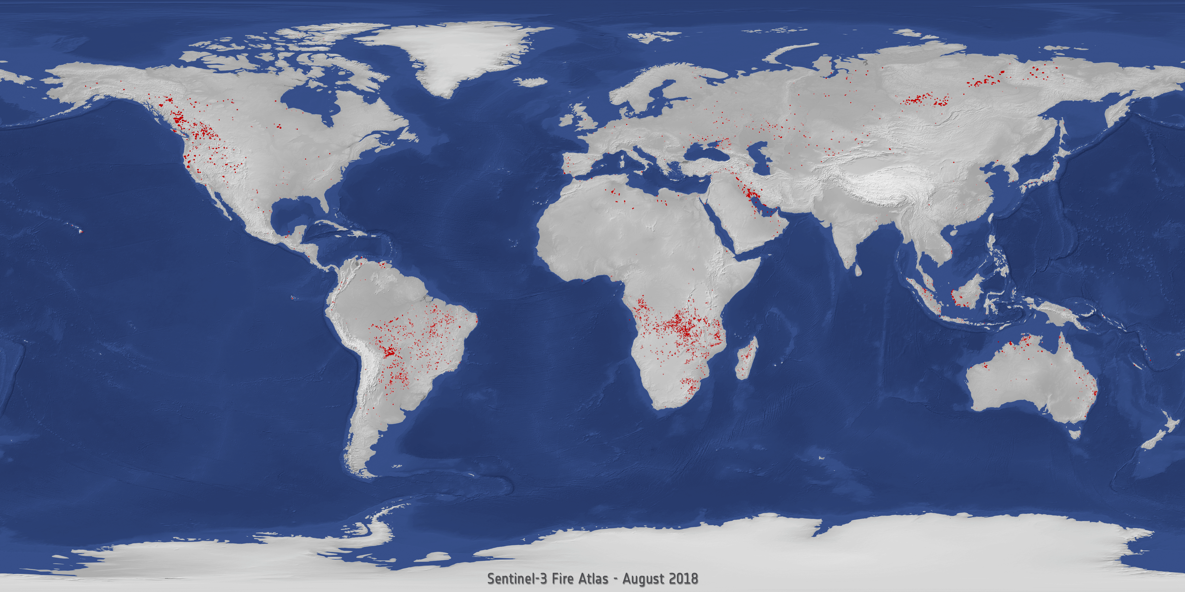
Wildfires have been making headlines again this month, with multiple fires burning in Lebanon and California, but these are just some of the many fires 2019 has seen. Fires in the Amazon sparked a global outcry this summer, but fires have also been blazing in the Arctic, France, Greece, Indonesia as well as many other areas in the world.
Sonda Solar Orbiter je připravena vydat se na kosmodrom
25.10.2019 10:34 Český Kosmický PortálSonda ESA Solar Orbiter dokončila svoji testovací kampaň v Evropě a je nyní připravena na cestu na mys Canaveral, k níž by mělo dojít koncem tohoto měsíce. Z místního kosmodromu se pak v únoru 2020 vydá do vesmíru.
Earth from Space: Leelanau Peninsula
25.10.2019 10:00 ESA Observing the Earth Video:
00:02:51
Video:
00:02:51
In this week's edition of the Earth from Space programme, the Copernicus Sentinel-2 missiontakes us over the Leelanau Peninsula on the northwest coast of Northern Michigan, US.
See also Leelanau Peninsula, US to download the image.
Earth from Space: Leelanau Peninsula
25.10.2019 10:00 ESA Observing the Earth
Video:
00:02:51
In this week's edition of the Earth from Space programme, the Copernicus Sentinel-2 missiontakes us over the Leelanau Peninsula on the northwest coast of Northern Michigan, US.
See also Leelanau Peninsula, US to download the image.
Leelanau Peninsula, US
25.10.2019 10:00 ESA Observing the Earth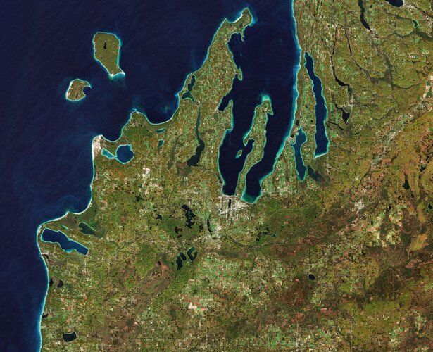 Image:
The Copernicus Sentinel-2 mission takes us over the Leelanau Peninsula on the northwest coast of Northern Michigan, US.
The region is shaped by rolling hills, large inland lakes shaped by glaciers around 20 000 years ago which form the basis for great farmland. The body of water that surrounds the peninsula is Lake Michigan, one of the five Great Lakes of North America and the only one located entirely within the US.
In the image, the bright turquoise in the water shows sediments, algae and chlorophyll in the shallower waters along the shore. The greener colours visible in Lake Leelanau to the north, Platte Lake to the west, and several inland bodies of water are due to a combination of a high chlorophyll and plant content.
The Sleeping Bear Dunes Lakeshore extend for around 55 km along the coast of the peninsula, and is visible in light brown. The name comes from an Ojibwa legend in which a mother bear and her two cubs swim across the lake trying to escape a forest fire. The two cubs are said to have disappeared in the process, and the mother bear waited for weeks for them to re-surface before finally falling asleep and never waking. Touched by her suffering, a powerful spirit is said to have covered her with sand, and raised the two cubs above the water, creating the North and South Manitou islands, visible north of the peninsula.
A more realistic explanation of the creation of the Sleeping Bear Dunes is geology. During the last Ice Age, glaciers spread southwards from Canada burying this area under sheets of ice. During the process, piles of sand and rock were deposited in the area. When the ice retreated and melted, it left the hilly terrain that exists along the lake today. The area is popular for hiking and climbing.
This image, which was captured on 18 October 2018, is also featured on the Earth from Space video programme.
Oznámení o vyhlášení výběrového řízení
25.10.2019 9:25 ČÚZK - předpisy a opatření Katastrální úřad pro Královéhradecký kraj zveřejnil novou aktualitu: Oznámení o vyhlášení výběrového řízení na služební místo vedoucí oddělení hospodářské správy kanceláře ředitele Katastrálního úřadu pro Královéhradecký krajvedoucí oddělení hospodářské správy kanceláře ředitele Katastrálního úřadu pro Královéhradecký kraj
25.10.2019 9:19 ČÚZK - předpisy a opatření Katastrální úřad pro Královéhradecký kraj - kancelář úřaduvypisuje výběrové řízení na místo
vedoucí oddělení hospodářské správy kanceláře ředitele Katastrálního úřadu pro Královéhradecký kraj
vedoucí oddělení hospodářské správy kanceláře ředitele Katastrálního úřadu pro Královéhradecký kraj
25.10.2019 9:19 ČÚZK /Urady/Katastralni-urady/Katastralni-urady/Katastralni-urad-pro-Kralovehradecky-kraj/Uredni-deska/Oznameni-a-jina-uredni-sdeleni/Volna-mista/vedouci-oddeleni-hospodarske-spravy-kancelare-redivedoucí oddělení hospodářské správy kanceláře ředitele Katastrálního úřadu pro Královéhradecký kraj
25.10.2019 9:19 ČÚZK - volná místa Katastrální úřad pro Královéhradecký kraj - kancelář úřadu vypisuje výběrové řízení na místo vedoucí oddělení hospodářské správy kanceláře ředitele Katastrálního úřadu pro Královéhradecký krajArcGIS API for Python Core Concepts: Python, APIs, and REST (ArcUser Online)
25.10.2019 9:00 GISCafe.com Webcasts-WebinarsCloud-Based National Parcel Layer Grants Users Access to Greater Detail (ArcNews Online)
25.10.2019 9:00 GISCafe.com Webcasts-Webinarsúčetní
25.10.2019 8:03 ČÚZK - předpisy a opatření Katastrální úřad pro Jihočeský kraj kancelář ředitelevypisuje výběrové řízení na místo
účetní
účetní
25.10.2019 8:03 ČÚZK /Urady/Katastralni-urady/Katastralni-urady/Katastralni-urad-pro-Jihocesky-kraj/Volna-mista/DMS/ucetniúčetní
25.10.2019 8:03 ČÚZK - volná místa Katastrální úřad pro Jihočeský kraj kancelář ředitele vypisuje výběrové řízení na místo účetníAktualizace dat v mapových aplikacích
25.10.2019 7:35 Jihočeský kraj Mapová aplikace Technická infrastruktura a mapová aplikace Zastavěné území byly aktualizovány k 25.10.2019.INSPIRE téma Adresy (AD)
25.10.2019 2:00 Cenia - Katalog metadat ČR - INSPIRE Data odpovídají směrnici INSPIRE pro téma adresy (AD). Vychází především z projektu RÚIAN (Registr územní identifikace, adres a nemovitostí), který je součástí základních registrů České Republiky a obsahuje informace o územní identifikaci, adresách a nemovitostech. Data publikovaná v rámci INSPIRE obsahují pouze adresní místa a jejich komponenty, kterými jsou stát, obec, část obce, městský obvod v Praze (MOP), městký obvod/městská část (MO/MČ), ulice a pošta a to na území celé České Republiky. Obsahují rozvněž geometrii, která určuje definiční bod adresního místa. V datové sadě nění uvedeno 1,31%, t.j. 38397 adresních míst (k 21. 10. 2019), protože neobsahují definiční bod, podle kterého by je bylo možné prostorově určit. Více v zákoně č. 111/2009 Sb., o základních registrech a ve vyhlášce č. 359/2011 Sb., o základním registru územní identifikace, adres a nemovitostí v platných zněních a INSPIRE Data Specification on Addresses v 3.0.1 z 26.4.2010. Data ve formátu GML 3.2.1 jsou validní proti schématu XML pro INSPIRE téma Adresy ve verzi 4.0 a proti schématu pro prostorová data ELF ve verzi 1.0.INSPIRE téma Parcely (CP)
25.10.2019 2:00 Cenia - Katalog metadat ČR - INSPIRE Data odpovídají směrnici INSPIRE pro téma katastrální parcely (CP). Vychází z katastrální mapy, která je závazným státním mapovým dílem velkého měřítka, obsahuje body polohového bodového pole, polohopis a popis a může mít formu digitální mapy, analogové mapy nebo digitalizované mapy. Data publikovaná v rámci INSPIRE obsahují pouze katastrální území (pro celou Českou Republiku) a parcely a jejich hranice z území, kde je digitální mapa (k 21. 10. 2019 je to 96,61% území České republiky, t.j. 76 196,37km2). Více katastrální zákon 344/1992 SB., katastrální vyhláška č.26/2007 Sb. v platném znění a INSPIRE Data Specification on Cadastral Parcels v 3.0.1. Data ve formátu GML 3.2.1 jsou validní proti schématu XML pro INSPIRE téma Parcely ve verzi 4.0 a proti schématu pro prostorová data ELF ve verzi 1.0.Katastrální mapa v rastrové podobě poskytovaná v e-shopu
25.10.2019 2:00 Cenia - Katalog metadat ČR - INSPIRE Katastrální mapa v rastrové podobě je poskytována za úplatu a obsahuje analogovou mapu s kompletní kresbou. Analogová mapa pokrývá 3,34 % území České republiky, což je 2 630,62km2. Více katastrální vyhláška č.357/2013 Sb. v platném znění.INSPIRE téma Budovy (BU)
25.10.2019 2:00 Cenia - Katalog metadat ČR - INSPIRE Data odpovídají směrnici INSPIRE pro téma budovy (BU). Data pochází částečně z projektu RÚIAN (Registr územní identifikace, adres a nemovitostí), který je součástí základních registrů České Republiky a obsahuje informace o územní identifikaci, adresách a nemovitostech, a částečně z ISKN (Informační systém katastru nemovistostí). Zdrojem informací o budovách v ISKN je objekt Stavba, v RÚIAN je to Stavební objekt. Většina Staveb je zároveň Stavebními objekty, ale jsou případy, kdy tomu tak není. Kromě Budov datová sada obsahuje i části budov, které jsou pro potřeby INSPIRE vyjádřeny vchody z RÚIAN. Vchody obsahují informace o počtu podlaží, technickoekonomických atributech apod. Datová sada pokrývá celé území české republiky. V datové sadě není uvedeno 1,17%, t.j. 49192 budov (k 21. 10. 2019), protože neobsahují definiční bod ani polygon. Více v zákoně č. 111/2009 Sb., o základních registrech, ve vyhlášce č. 359/2011 Sb., o základním registru územní identifikace, adres a nemovitostí v platných zněních, v zákoně 256/2013 Sb., o katastru nemovitostí, v katastrální vyhlášce č. 357/2013 Sb. v platném znění a INSPIRE Data Specification on Buildings v 3.0 z 13.12.2013. Data ve formátu GML 3.2.1 jsou validní proti schématu XML pro INSPIRE téma Budovy ve verzi 4.0 a proti schématu pro prostorová data ELF ve verzi 1.0.Katastrální mapa ve formátech DGN a DXF poskytovaná v e-shopu
25.10.2019 2:00 Cenia - Katalog metadat ČR - INSPIRE Katastrální mapa je závazným státním mapovým dílem velkého měřítka, obsahuje body polohového bodového pole, polohopis a popis. Katastrální mapa ve vektorové podobě je poskytována zdarma ve formátu DGN a DXF a obsahuje prvky Digitální katastrální mapy (DKM) a Katastrální mapy digitalizované (KMD), tedy bodová pole, budovy, další prvky mapy, hranice parcel, katastrální hranice, parcely katastru nemovitostí, prvky orientační mapy a hranice věcného břemene. Z důvodu použití formátu DGN produkt neobsahuje značky na liniích a oblouky jsou nahrazeny lomenými čárami. Katastrální mapa ve vektorové podobě k 21. 10. 2019 pokrývá 96,61% území České republiky, t.j. 76 196,37km2. Více katastrální vyhláška č.357/2013 Sb. v platném znění.Mozambique Is Early Adopter of Esri Land Administration Modernization Program
25.10.2019 0:55 GISCafe.com Webcasts-Webinars New Program Empowers Developing Countries to Improve Land Management with Rich Mapping FunctionalityREDLANDS, Calif. — (BUSINESS WIRE) — …
ESA and Airbus to cooperate on the Bartolomeo platform
24.10.2019 20:27 GISCafe.com Webcasts-Webinars Washington D.C., 24 October 2019 – The European Space Agency (ESA) and Airbus Defence and Space today signed a Statement of Intent on their …USGIF Offers First Entry-Level Geospatial Intelligence Certification of its Kind
24.10.2019 20:11 GISCafe.com Webcasts-Webinars “The Essentials” exam provides recent graduates and young professionals the opportunity to demonstrate knowledge across foundational …UNOOSA and Airbus announce opportunity for utilizing Airbus Bartolomeo platform
24.10.2019 20:01 GISCafe.com Webcasts-Webinars VIENNA and WASHINGTON D.C., 24 October 2019 – At the International Astronautical Congress (IAC) in Washington D.C., the United Nations Office …Purple WiFi supercharges intelligent space proposition by acquiring indoor navigation specialist
24.10.2019 19:12 GISCafe.com Webcasts-Webinars Deal will combine the power of indoor navigation tech with data analyticsThe acquired solution utilises the Earth’s geomagnetic forces for …
Bentley Systems Announces New iTwin Cloud Services for Infrastructure Engineering Digital Twins
24.10.2019 19:12 GISCafe.com Webcasts-Webinars SINGAPORE, Oct. 24, 2019 — (PRNewswire) — The Year in Infrastructure 2019 Conference -- Bentley Systems, Incorporated, the leading …HawkEye 360 Expands Signal Catalog to Address New Markets
24.10.2019 19:12 GISCafe.com Webcasts-Webinars Expanded signal catalog will benefit border security applicationsHERNDON, Va., Oct. 24, 2019 — (PRNewswire) — HawkEye 360 Inc., …
'Drones are Now': UAS Industry Leaders Partner to Kick Off FAA National Drone Safety Awareness Week
24.10.2019 19:12 GISCafe.com Webcasts-Webinars Commercial UAV Expo Americas, DRONERESPONDERS, National Press Photographers Association, Sundance Media Group, and others to host special October 29 …The Wild for Autodesk’s BIM 360® Allows AEC Teams to Collaborate on BIM Content in VR/AR from Anywher
24.10.2019 16:13 GISCafe.com Webcasts-WebinarsThe Wild for Autodesk’s BIM 360® Allows AEC Teams to Collaborate on BIM Content in VR/AR from Anywhere
24.10.2019 16:13 GISCafe.com Webcasts-WebinarsÚspěch naší studentky v soutěži o nejlepší studentskou vědeckou práci [Katedra aplikované geoinformatiky a kartografie, byTopic]
24.10.2019 13:20 Katedra aplikované geoinformatiky a kartografie Přf UK Bc. Daniela Valchářová se svojí bakalářskou prací Tematický atlas Církve adventistů sedmého dne, obhájenou na katedře aplikované geoinformatiky a kartografie, obsadila v celostátním kole soutěže o nejlepší studentskou vědeckou práci 2. místo. Gratulujeme!"Bentley Year In Infrastructure 2019 Offers GIS Refresh" by Susan Smith
24.10.2019 12:41 GISCafe.com Webcasts-WebinarsUPsolventi geoinformatiky
24.10.2019 11:30 Katedra geoinformatiky UP OlomoucVydáváme nový informační materiál o našich absolventech! Přečtěte si, jak oni vnímají studia na KGI, co dělají, co pre ně znamená geoinformatika….
The post UPsolventi geoinformatiky appeared first on Katedra geoinformatiky.
vrchní referent / rada v oddělení právních vztahů k nemovitostem KP CR
24.10.2019 10:26 ČÚZK /Urady/Katastralni-urady/Katastralni-urady/Katastralni-urad-pro-Pardubicky-kraj/Uredni-deska/Oznameni-a-jina-uredni-sdeleni/Volna-mista/DMS/vrchni-referent-rada-v-oddeleni-pravnich-vztahuvrchní referent / rada v oddělení právních vztahů k nemovitostem KP CR
24.10.2019 10:26 ČÚZK - volná místa Katastrální úřad pro Pardubický kraj Katastrální pracoviště Chrudim vypisuje výběrové řízení na místo vrchní referent / rada v oddělení právních vztahů k nemovitostem KP CRvrchní referent / rada v oddělení právních vztahů k nemovitostem KP CR
24.10.2019 10:26 ČÚZK - předpisy a opatření Katastrální úřad pro Pardubický kraj Katastrální pracoviště Chrudimvypisuje výběrové řízení na místo
vrchní referent / rada v oddělení právních vztahů k nemovitostem KP CR
ArcGIS Urban Transforms City Planning (ArcNews Online)
24.10.2019 9:00 GISCafe.com Webcasts-WebinarsPřevod Dolní oblasti Vítkovic do 3D BIM modelu
24.10.2019 3:48 Konference BIM OpenPřevod vysoké pece z bývalé industriální zóny v srdci Ostravy z mračna bodů laserového skenování až do 3D BIM modelu v Revitu. Záznam z konference BIM Open, která se konala 17.9.2019 v Ostravě.
The post Převod Dolní oblasti Vítkovic do 3D BIM modelu appeared first on BIM Open.
INSPIRE prohlížecí služba pro téma Využití území - Ústecký kraj
24.10.2019 2:00 Cenia - Katalog metadat ČR - INSPIRE data odvozená z ploch a koridorů Zásad územního rozvoje Ústeckého krajeprostorové rozlišení 1:100.000 (měřítko vydání ZÚR)údržba je vázána na vydávané aktualizace ZÚRpodmínky pro přístup a užití - bez omezeníomezení veřejného přístupu - bez omezenísilniční doprava
24.10.2019 2:00 Cenia - Katalog metadat ČR - INSPIRE data odvozená z ploch a koridorů Zásad územního rozvoje Ústeckého krajeprostorové rozlišení 1:100.000 (měřítko vydání ZÚRúdržba je vázána na vydávané aktualizace ZÚRpodmínky pro přístup a užití - bez omezeníomezení veřejného přístupu - bez omezenívodní doprava
24.10.2019 2:00 Cenia - Katalog metadat ČR - INSPIRE data odvozená z ploch a koridorů Zásad územního rozvoje Ústeckého krajeprostorové rozlišení 1:100.000 (měřítko vydání ZÚRúdržba je vázána na vydávané aktualizace ZÚRpodmínky pro přístup a užití - bez omezeníomezení veřejného přístupu - bez omezeníINSPIRE stahovací služba pro téma Využití území - Ústecký kraj
24.10.2019 2:00 Cenia - Katalog metadat ČR - INSPIRE data odvozená z ploch a koridorů Zásad územního rozvoje Ústeckého krajeprostorové rozlišení 1:100.000 (měřítko vydání ZÚR)údržba je vázána na vydávané aktualizace ZÚRpodmínky pro přístup a užití - bez omezeníomezení veřejného přístupu - bez omezenípřírodní plochy, které nejsou jinak hospodářsky využívány
24.10.2019 2:00 Cenia - Katalog metadat ČR - INSPIRE data odvozená z ploch a koridorů Zásad územního rozvoje Ústeckého krajeprostorové rozlišení 1:100.000 (měřítko vydání ZÚRúdržba je vázána na vydávané aktualizace ZÚRpodmínky pro přístup a užití - bez omezeníomezení veřejného přístupu - bez omezeníjiná dopravní síť
24.10.2019 2:00 Cenia - Katalog metadat ČR - INSPIRE data odvozená z ploch a koridorů Zásad územního rozvoje Ústeckého krajeprostorové rozlišení 1:100.000 (měřítko vydání ZÚRúdržba je vázána na vydávané aktualizace ZÚRpodmínky pro přístup a užití - bez omezeníomezení veřejného přístupu - bez omezeníkolejová doprava
24.10.2019 2:00 Cenia - Katalog metadat ČR - INSPIRE data odvozená z ploch a koridorů Zásad územního rozvoje Ústeckého krajeprostorové rozlišení 1:100.000 (měřítko vydání ZÚRúdržba je vázána na vydávané aktualizace ZÚRpodmínky pro přístup a užití - bez omezeníomezení veřejného přístupu - bez omezenítěžba energetických surovin
24.10.2019 2:00 Cenia - Katalog metadat ČR - INSPIRE data odvozená z ploch a koridorů Zásad územního rozvoje Ústeckého krajeprostorové rozlišení 1:100.000 (měřítko vydání ZÚRúdržba je vázána na vydávané aktualizace ZÚRpodmínky pro přístup a užití - bez omezeníomezení veřejného přístupu - bez omezeníCoreLogic Reports Third Quarter 2019 Financial Results
24.10.2019 1:34 GISCafe.com Webcasts-Webinars Significant Margin Expansion, Favorable Revenue Mix and Growth Highlight Strong Operating Performance; 2019 Full-Year Guidance IncreasedIRVINE, …
‘Drones are Now’: UAS Industry Leaders Partner to Kick Off FAA National Drone Safety Awareness Week
23.10.2019 21:03 GISCafe.com Webcasts-Webinars Commercial UAV Expo Americas, DRONERESPONDERS, National Press Photographers Association, Sundance Media Group, and others to host special …
OGC invites you to its Augmented Reality Summit in Toulouse, France
23.10.2019 19:08 GISCafe.com Webcasts-Webinars OGC’s November 2019 AR Summit will bring together experts to discuss how to standardize access to AR related data and services, and encourage …FortifyData and InterDev Partner to Deliver Complete Cyber-Risk Management Solutions
23.10.2019 16:50 GISCafe.com Webcasts-Webinars ROSWELL, Ga. and ATLANTA, Oct. 22, 2019 — (PRNewswire) — Today, FortifyData and InterDev announced a partnership that will allow …Bentley Systems Accelerates Focus on Infrastructure Engineering for Digital Cities
23.10.2019 16:50 GISCafe.com Webcasts-Webinars SINGAPORE, Oct. 22, 2019 — (PRNewswire) — The Year in Infrastructure 2019 Conference -- Bentley Systems, Incorporated, the leading …Trimble's Compact GNSS Board Adds Flexibility and High-Precision Positioning to Unmanned Aerial Systems
23.10.2019 16:50 GISCafe.com Webcasts-Webinars SUNNYVALE, Calif., Oct. 23, 2019 — (PRNewswire) — Trimble (NASDAQ:TRMB) introduced today a compact, high-precision Global …Trimble's Compact GNSS Board Adds Flexibility and High-Precision Positioning to Unmanned Aerial Systems
23.10.2019 16:50 GISCafe.com Webcasts-Webinars SUNNYVALE, Calif., Oct. 23, 2019 — (PRNewswire) — Trimble (NASDAQ:TRMB) introduced today a compact, high-precision Global …Bentley Systems Accelerates Focus on Infrastructure Engineering for Digital Cities
23.10.2019 16:50 GISCafe.com Webcasts-Webinars SINGAPORE, Oct. 22, 2019 — (PRNewswire) — The Year in Infrastructure 2019 Conference -- Bentley Systems, Incorporated, the …
RedTail LiDAR Systems Unveils Innovative 3D Mapping Solution at Commercial UAV EXPO
23.10.2019 16:50 GISCafe.com Webcasts-Webinars RTL-400 introduced as high-resolution LiDAR system for small dronesFAIRMONT, W.Va., Oct. 23, 2019 — (PRNewswire) — RedTail LiDAR …
Drone Delivery Canada announces commercial agreement with DSV Canada
23.10.2019 16:50 GISCafe.com Webcasts-Webinars TORONTO, Oct. 23, 2019 — (PRNewswire) — Drone Delivery Canada Corp. (TSXV: FLT, OTC: TAKOF) (the "Company" or "DDC") is pleased to …Výstava Albertov 1989 v Jičíně [Knihovna geografie, byTopic]
23.10.2019 13:20 Katedra aplikované geoinformatiky a kartografie Přf UK Již 10 let putuje českými knihovnami úspěšná výstava Knihovny geografie Albertov 1989. Nyní bude aktuálně vystavena od 21. října do 6. prosince 2019 v Městské knihovně Václava Čtvrtka v Jičíně.Pozvánka na 20. konferenci Archivy, knihovny, muzea v digitálním světě 2019 [Knihovna geografie, byTopic]
23.10.2019 13:05 Katedra aplikované geoinformatiky a kartografie Přf UK Konference proběhne 2. až 4. prosince 2019 v konferenčním sále Národního archivu v Praze, Archivní 4, Praha 4 - Chodovec.Save the Date: Live demo of first Galileo-enabled autonomous vehicle
23.10.2019 11:12 European GNSS Agency
Connected and Automated Driving is transforming the way vehicles are operated and integrated in the connected mobility ecosystem, and Europe’s GNSS programme Galileo is at the heart of this transformation. Join us at the University of Technology of Compiègne, France, on 27 November for a live demonstration of the first Galileo-enabled autonomous vehicle made in the EU and see for yourself how Galileo is driving the future of autonomous vehicles.
Participants in the day-long event will have a unique opportunity to ride in an autonomous vehicle fitted with a Galileo-enabled ESCAPE GNSS engine (EGE). The EGE is an innovative positioning engine that leverages the Galileo signals and services to provide a core positioning component in autonomous vehicles. It was designed and prototyped by the ESCAPE project, funded under the European GNSS Agency’s (GSA) Fundamental Elements programme.
Live demonstrations
Cars equipped with this engine will be showcased in two demonstrations at the event. The first demo will involve two Renault Zoe electric cars being (autonomously) driven at the same time. During the demo, participants and journalists will have a unique opportunity to get on board the vehicles and take a driverless ride on the University of Technology of Compiègne (UTC) track.
Read this: ESCAPE project launches positioning module for autonomous driving
In the second demo, a third vehicle will be driven on a public road in Compiègne to demonstrate its performance in a peri-urban environment. There will be no passengers in this car, but the participants will be able to watch a live video of the test broadcast via 4G with the estimated position obtained using the EGE equipped with the RTK high accuracy technique. The demos will be followed by a Q&A session where journalists and other participants will be able to put their questions to the developers of the engine.
“The EGE hardware has been developed based on state-of-the-art practices in the design of automotive electronic control units and is based on the first automotive grade GNSS and Galileo receiver. As a result, all of its interfaces and configurations have been developed to be fully compliant with the most widely recognised trends in the sector,” said GSA Head of Market Development Fiammetta Diani.
Participation in the event is free of charge, but places are limited. So if you are interested in the future of mobility and would like to take part in this exciting live demo, sign up now!
Localisation workshop
The demos will be followed by a series of presentations on the ESCAPE project, including use cases for autonomous driving, high accuracy and integrity, localisation standards, and HD maps for localisation. There will also be a presentation of the TESEO APP receiver from STMicroelectronics, which combines multiple-frequency and multi-constellation tracking and enables autonomous-driving systems to combine precise positioning with sensor data for enhanced performance, safety and reliability.
Following the presentations, there will be a workshop on localisation integrity for autonomous driving, with discussions on relative and absolute localisation and integrity estimation for land-based applications. All in all, this is a not-to-be-missed event for anybody interested in intelligent transport systems and autonomous driving.
The ESCAPE prototype
The EGE prototype design includes several major components, including a novel multi-frequency, multi-constellation automotive-grade GNSS receiver. The main distinguishing feature of the ESCAPE receiver is its ability to precisely and simultaneously process signals from two different GNSS bands and from different satellite constellations. Although this capability is common in high-end professional receivers, it is cutting-edge in the automotive Tier-2 panorama.
And this: European GNSS supports smarter mobility
The receiver is also a first-of-a-kind device in its segment to support the new Navigation Message Authentication (NMA) service of Galileo, the additional anti-spoofing service to be offered by Galileo on the open E1 signal. Finally, the new GNSS receiver comes with several core signal-processing enhancements: better receiver sensitivity and tracking capability, multipath mitigation, more intermediate frequency (IF) channels and flexibility in routing IF samples, jamming detection and mitigation, and optimisation of the GNSS data flow.
The result is an ESCAPE GNSS sensor that combines a high-end GNSS technology traditionally reserved for professional applications, innovative dual-band Galileo processing, as well as all the hardware and software safety aspects that are needed to certify the component for the automotive market.
Media note: This feature can be republished without charge provided the European GNSS Agency (GSA) is acknowledged as the source at the top or the bottom of the story. You must request permission before you use any of the photographs on the site. If you republish, we would be grateful if you could link back to the GSA website (http://www.gsa.europa.eu).
Save the Date: Live demo of first Galileo-enabled autonomous vehicle
23.10.2019 11:12 European GNSS AgencyConnected and Automated Driving is transforming the way vehicles are operated and integrated in the connected mobility ecosystem, and Europe’s GNSS programme Galileo is at the heart of this transformation. Join us at the University of Technology of Compiègne, France, on 27 November for a live demonstration of the first Galileo-enabled autonomous vehicle made in the EU and see for yourself how Galileo is driving the future of autonomous vehicles.
Participants in the day-long event will have a unique opportunity to ride in an autonomous vehicle fitted with a Galileo-enabled ESCAPE GNSS engine (EGE). The EGE is an innovative positioning engine that leverages the Galileo signals and services to provide a core positioning component in autonomous vehicles. It was designed and prototyped by the ESCAPE project, funded under the European GNSS Agency’s (GSA) Fundamental Elements programme.
Live demonstrations
Cars equipped with this engine will be showcased in two demonstrations at the event. The first demo will involve two Renault Zoe electric cars being (autonomously) driven at the same time. During the demo, participants and journalists will have a unique opportunity to get on board the vehicles and take a driverless ride on the University of Technology of Compiègne (UTC) track.
Read this: ESCAPE project launches positioning module for autonomous driving
In the second demo, a third vehicle will be driven on a public road in Compiègne to demonstrate its performance in a peri-urban environment. There will be no passengers in this car, but the participants will be able to watch a live video of the test broadcast via 4G with the estimated position obtained using the EGE along with RTK. The demos will be followed by a Q&A session where journalists and other participants will be able to put their questions to the developers of the engine.
“The EGE hardware has been developed based on state-of-the-art practices in the design of automotive electronic control units and is based on the first automotive grade GNSS and Galileo receiver. As a result, all of its interfaces and configurations have been developed to be fully compliant with the most widely recognised trends in the sector,” said GSA Head of Market Development Fiammetta Diani.
Participation in the event is free of charge, but places are limited. So if you are interested in the future of mobility and would like to take part in this exciting live demo, sign up now!
Localisation workshop
The demos will be followed by a series of presentations on the ESCAPE project, including use cases for autonomous driving, high accuracy and integrity, localisation standards, and HD maps for localisation. There will also be a presentation of the TESEO APP receiver from STMicroelectronics, which combines multiple-frequency and multi-constellation tracking and enables autonomous-driving systems to combine precise positioning with sensor data for enhanced performance, safety and reliability.
Following the presentations, there will be a workshop on localisation integrity for autonomous driving, with discussions on relative and absolute localisation and integrity estimation for land-based applications. All in all, this is a not-to-be-missed event for anybody interested in intelligent transport systems and autonomous driving.
The ESCAPE prototype
The EGE prototype design includes several major components, including a novel multi-frequency, multi-constellation automotive-grade GNSS receiver. The main distinguishing feature of the ESCAPE receiver is its ability to precisely and simultaneously process signals from two different GNSS bands and from different satellite constellations. Although this capability is common in high-end professional receivers, it is cutting-edge in the automotive Tier-2 panorama.
And this: European GNSS supports smarter mobility
The receiver is also a first-of-a-kind device in its segment to support the new Navigation Message Authentication (NMA) service of Galileo, the additional anti-spoofing service to be offered by Galileo on the open E1 signal. Finally, the new GNSS receiver comes with several core signal-processing enhancements: better receiver sensitivity and tracking capability, multipath mitigation, more intermediate frequency (IF) channels and flexibility in routing IF samples, jamming detection and mitigation, and optimisation of the GNSS data flow.
The result is an ESCAPE GNSS sensor that combines a high-end GNSS technology traditionally reserved for professional applications, innovative dual-band Galileo processing, as well as all the hardware and software safety aspects that are needed to certify the component for the automotive market.
Media note: This feature can be republished without charge provided the European GNSS Agency (GSA) is acknowledged as the source at the top or the bottom of the story. You must request permission before you use any of the photographs on the site. If you republish, we would be grateful if you could link back to the GSA website (http://www.gsa.europa.eu).
GfK updates maps for all of Europe
23.10.2019 11:08 GISCafe.com Webcasts-Webinars Europe Edition 2019/2020 features latest administrative and postcode boundariesBruchsal, Germany, October 22, 2019 – GfK has released …
Optimizing Elections⏤GIS Improves Preparation and Execution for County (ArcUser Online)
23.10.2019 9:00 GISCafe.com Webcasts-WebinarsDo More with ArcGIS Runtime SDKs 100.5 (ArcUser Online)
23.10.2019 9:00 GISCafe.com Webcasts-Webinarsosobní automobil Suzuki Ignis 1.3
23.10.2019 8:13 ČÚZK /Urady/Katastralni-urady/Katastralni-urady/Katastralni-urad-pro-Jihocesky-kraj/Nabidky-majetku/osobni-automobil-Suzuki-Ignis-1-3osobní automobil Suzuki Ignis 1.3
23.10.2019 8:13 ČÚZK - předpisy a opatřeníKatastrální úřad pro Jihočeský kraj nabízí nepotřebný majetek k odkupu. Jedná se o
osobní automobil Suzuki Ignis 1.3
Maxar Technologies and Australian Space Agency Sign Cooperative Agreement
23.10.2019 1:45 GISCafe.com Webcasts-Webinars WESTMINSTER, Colo. — (BUSINESS WIRE) — October 22, 2019 —Maxar Technologies (NYSE:MAXR) (TSX:MAXR), a trusted partner and …
GBDAA SkyVision team recognized for advances in safe integration of drones into the National Airspace System
23.10.2019 1:45 GISCafe.com Webcasts-Webinars WASHINGTON, Oct. 22, 2019 — (PRNewswire) — Raytheon Company's (NYSE: RTN) Ground Based Detect and Avoid team received the Air …
Carlson Releases Exclusive Scan Software for the C-ALS® and Void Scanner
22.10.2019 21:27 Carlson Software MAYSVILLE, Kentucky, U.S.A. (October 2019) — Carlson Scan has just been released for enhanced operation of Carlson’s C-ALS, C-ALS Gyro, Void Scanner, and, soon-to-be-released, VS+ laser scanning systems. Designed for ruggedized, touchscreen tablets, Carlson Scan was developed for in-the-field use and features a smooth interface to control the scanner, analyze the collected data, and produce […]OGC announces new JSON Encoding Extension to its Moving Features Standard; seeks public comment before approval
22.10.2019 20:37 GISCafe.com Webcasts-Webinars New Moving Features Extension provides a JSON encoding as an alternative to XML or Simple CSV22 October 2019: The Open Geospatial Consortium …
TerraView Unveils Enterprise UAV with More Than 70-Minute Flight Time
22.10.2019 20:11 GISCafe.com Webcasts-Webinars RangePro X8 is proudly designed and assembled in the U.S.A.Valencia, CA ( October 21, 2019 ) — TerraView, a California-based aerial …
EIA Canadian leader in using drones for safety
22.10.2019 20:02 GISCafe.com Webcasts-Webinars Edmonton, AB, Oct. 22, 2019 (GLOBE NEWSWIRE) -- – A different kind of aircraft landed at Edmonton International Airport this past weekend …The Lidar Revolution: Enabling Machines to See the World, as Discussed in the New IDTechEx Research Report
22.10.2019 20:02 GISCafe.com Webcasts-Webinars New report from IDTechEx Research forecasts the global market for lidar in autonomous vehicles growing to $5.4 billion by 2030. Analysis of 100+ 3D …ILMF & LIDAR Mag Open Nominations for 2020 Lidar Leader Awards
22.10.2019 20:02 GISCafe.com Webcasts-Webinars International Lidar Mapping Forum (ILMF) and LIDAR Magazine will be accepting nominations for the 2020 Lidar Leader Awards now through December 13, …The Lidar Revolution: Enabling Machines to See the World, as Discussed in the New IDTechEx Research Report
22.10.2019 20:02 GISCafe.com Webcasts-Webinars New report from IDTechEx Research forecasts the global market for lidar in autonomous vehicles growing to $5.4 billion by 2030. Analysis of …
Bentley Systems' Design Integration Offerings Advance BIM to 4D through Digital Twins
22.10.2019 16:42 GISCafe.com Webcasts-Webinars SINGAPORE, Oct. 21, 2019 — (PRNewswire) — The Year in Infrastructure 2019 Conference -- Bentley Systems, Incorporated, the leading …Robotic Skies Partners with SqwaQ to Advance Commercial Drone Operations BVLOS
22.10.2019 16:42 GISCafe.com Webcasts-Webinars Agreement grants distribution of SqwaQ technology to the global UAS fleet, with MRO support and retrofit through the Robotic Skies Network in over 40 …Bentley Systems Introduces AssetWise Digital Twin Services and OpenUtilities Digital Twin Services for Asset and Network Performance
22.10.2019 16:42 GISCafe.com Webcasts-Webinars SINGAPORE, Oct. 22, 2019 — (PRNewswire) — The Year in Infrastructure 2019 Conference -- Bentley Systems, Incorporated, the leading …Velodyne Lidar Executive Addresses How Velodyne’s Next Generation Sensors Enable True Vehicle Autonomy
22.10.2019 16:42 GISCafe.com Webcasts-Webinars Anand Gopalan, Velodyne Lidar CTO, Discusses Lidar’s Role in Autonomous Vehicle Success at PRECISE Industry Day ConferenceSAN JOSE, Calif. — …
Aktualizace dat ÚAP poskytovatelů Agentura ochrany přírody a krajiny ČR a Ředitelství silnic a dálnic ČR
22.10.2019 16:05 Plzeňský kraj V datech územně analytických podkladů Plzeňského kraje byla provedena aktualizace dat silniční sítě od poskytovatele Ředitelství silnic a dálnic ČR včetně vygenerování orientačního vymezení ochranných pásem silnic I., II. a III. třídy mimo zastavěné území a aktualizace dat maloplošných chráněných území a památných stromů od poskytovatele AOPK ČR.Aktualizace dat ÚAP poskytovatelů Agentura ochrany přírody a krajiny ČR, CETIN a.s., Správa železnic a ÚHUL.
22.10.2019 16:05 Plzeňský kraj V datech územně analytických podkladů Plzeňského kraje byla provedena aktualizace dat ve správě poskytovatelů AOPK ČR, CETIN a.s., Správa železnic s.o. a ÚHUL.Stavební akce na silnicích 2019
22.10.2019 15:35 Plzeňský kraj V seznamu mapových služeb oblasti Doprava a silniční hospodářství byly do interaktivní mapy Stavební akce na silnicích PK doplněny (z dat dodaných SÚS PK) Stavební akce 2019 realizované z rozpočtu SÚSPK, PK nebo SFDI.Stavební akce 2019 na silnicích PK
22.10.2019 15:35 Plzeňský kraj V seznamu mapových služeb oblasti Doprava a silniční hospodářství byly do interaktivní mapy Stavební akce 2019 na silnicích PK doplněny (z dat dodaných SÚS PK) Stavební akce 2019 realizované z rozpočtu SÚSPK, PK nebo SFDI.Hexagon Launches Power Portfolio 2020
22.10.2019 14:40 GISCafe.com Webcasts-Webinars Latest release improves collaboration, insights and results for geospatial professionals21 October 2019 - Hexagon’s Geospatial division, a …
Satellite-based remote lake health monitoring solution an aerospace winner
22.10.2019 14:40 GISCafe.com Webcasts-Webinars Seequent wins New Zealand aerospace innovation challenge; continues to expand its geoscience solutions to help solve earth, environment and energy …D28 iceberg takes a turn
22.10.2019 14:28 ESA Observing the Earth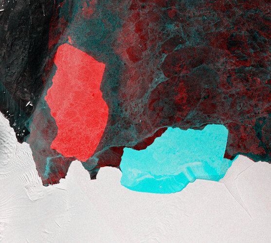 Image:
Earlier this month, the D28 iceberg was spotted breaking off from the Amery Ice Shelf in Antarctica. The iceberg, which is around 1600 sq km – about the size of Greater London – has now taken a 90 degree turn.
Captured by the Copernicus Sentinel-1 mission, this multitemporal false-colour image shows the before and after location of the iceberg produced by this calving event. Blue shows the iceberg before separation, taken on 20 September, while the red is where the iceberg was on 19 October after calving. Small red fragments of the iceberg can be seen floating in the vicinity of D28.
Approximately 30 km wide and 60 km long, and with a thickness exceeding 200 m, the iceberg is estimated to contain over 300 billion tonnes of ice.
Playmobil se vydal vzhůru a ještě dále s kosmonautem ESA Lucou Parmitanem
22.10.2019 10:35 Český Kosmický PortálFigurky Playmobil rozdávají radost miliónům dětí na celém světě. Nyní dvě z nich, které mají podobu kosmonauta ESA Lucy Parmitana, krouží na oběžné dráze Země společně s Parmitanem osobně.