


![]()

zprávy
zdroje zpráv:EagleView Unveils Game-Changing Shading Analysis Technology That Delivers Unprecedented Accuracy and Cuts Solar Project Completion Rates by Up to 50 Percent
23.9.2019 18:54 GISCafe.com Webcasts-Webinars New product, EagleView Inform Advanced™, allows solar companies to cut costs and save time due to more accurate property measurements, Solar …EagleView Unveils Game-Changing Shading Analysis Technology That Delivers Unprecedented Accuracy and Cuts Solar Project Completion Rates by Up to 50 Percent
23.9.2019 18:54 GISCafe.com Webcasts-Webinars New product, EagleView Inform Advanced™, allows solar companies to cut costs and save time due to more accurate property measurements, Solar Access …Betterview Integrates Geospatial Insurance Consortium's Aerial Imagery into its Property Risk Management Platform
23.9.2019 18:53 GISCafe.com Webcasts-Webinars Mutual Customers Can Now Generate Insights from High Resolution Imagery for Quoting, Renewals and Claims ProcessingLAS VEGAS, Sept. 23, 2019 …
Betterview Integrates Geospatial Insurance Consortium's Aerial Imagery into its Property Risk Management Platform
23.9.2019 18:53 GISCafe.com Webcasts-Webinars Mutual Customers Can Now Generate Insights from High Resolution Imagery for Quoting, Renewals and Claims ProcessingLAS VEGAS, Sept. 23, 2019 — …
Trimble Announces New Release of Advanced Wastewater Monitoring and Analytics Software for Municipalities and Utilities
23.9.2019 17:12 GISCafe.com Webcasts-Webinars New Release Extends Trimble Unity Remote Monitoring Software with Analytics and Workflows for Wastewater Utilities and EngineersCHICAGO, Sept. 23, …
"Compact Trimble X7 3D Laser Scanner Provides Integrated Solution for GIS and Survey Applications" by Susan Smith
23.9.2019 17:12 GISCafe.com Webcasts-WebinarsBlickfeld Presents New Long-Range LiDAR
23.9.2019 17:12 GISCafe.com Webcasts-Webinars Cube Range detects obstacles at a distance of up to 250 metersMUNICH — (BUSINESS WIRE) — September 23, 2019 —
Blickfeld, a …
AirMap Acquires Hangar Technology, Expanding its Capabilities and Technology Offerings to Serve Developers and Enterprises
23.9.2019 17:12 GISCafe.com Webcasts-Webinars Acquisition complements AirMap UTM platform offering and extends Hangar enterprise reach worldwideLOS ANGELES, Sept. 23, 2019 — (PRNewswire) …
Glympse and HERE Technologies Partner to Provide Last Mile Delivery, Curbside Pickup and Emergency Road-Side Assistance
23.9.2019 17:12 GISCafe.com Webcasts-Webinars Chicago, IL – HERE Technologies, a global leader in location platform services, and Glympse, the pioneer of real-time location sharing technology, …CityGML-Urban Planning ADE Ideathon will be held in Japan
23.9.2019 16:46 GISCafe.com Webcasts-Webinars In October and February, the Ideathon will discuss expanding the applications of CityGML and Urban Planning ADE in Japan, as well as the demand for …20190923 Rada / odborný rada oddělení aktualizace GI KN
23.9.2019 11:55 ČÚZK - předpisy a opatření Katastrální úřad pro Středočeský kraj - Katastrální pracoviště Praha-západ Vyhlášení výběrového řízení: Rada / odborný rada oddělení aktualizace GI KN V části "Úřední deska", v sekci "Oznámení a jiná úřední sdělení" bylo vystaveno "Oznámení o vyhlášení výběrového řízení na obsazení služebního místa Rada / odborný rada oddělení aktualizace GI KN"20190923 Rada / odborný rada oddělení aktualizace GI KN
23.9.2019 11:55 ČÚZK /Urady/Katastralni-urady/Katastralni-urady/Katastralni-urad-pro-Stredocesky-kraj/Katastralni-pracoviste/KP-Praha-zapad/O-uradu/Aktuality/20190923-Rada-odborny-rada-oddeleni-aktualizace20190923 Rada / odborný rada oddělení aktualizace GI KN
23.9.2019 11:52 ČÚZK /Urady/Katastralni-urady/Katastralni-urady/Katastralni-urad-pro-Stredocesky-kraj/O-uradu/Aktuality/20190923-Rada-odborny-rada-oddeleni-aktualizace20190923 Rada / odborný rada oddělení aktualizace GI KN
23.9.2019 11:52 ČÚZK - předpisy a opatření Katastrální úřad pro Středočeský kraj - Katastrální pracoviště Praha-západ Vyhlášení výběrového řízení: Rada / odborný rada oddělení aktualizace GI KN V části "Úřední deska", v sekci "Oznámení a jiná úřední sdělení" bylo vystaveno "Oznámení o vyhlášení výběrového řízení na obsazení služebního místa Rada / odborný rada oddělení aktualizace GI KN "rada / odborný rada oddělení aktualizace GI KN
23.9.2019 11:49 ČÚZK /Urady/Katastralni-urady/Katastralni-urady/Katastralni-urad-pro-Stredocesky-kraj/Uredni-deska/Oznameni-a-jina-uredni-sdeleni/Volna-mista/rada-odborny-rada-oddeleni-aktualizace-GI-KNRada / odborný rada oddělení aktualizace GI KN
23.9.2019 11:49 ČÚZK - předpisy a opatření Katastrální úřad pro Středočeský kraj - Katastrální pracoviště Praha-západvypisuje výběrové řízení na místo rada / odborný rada oddělení aktualizace GI KN
Rada / odborný rada oddělení aktualizace GI KN
Rada / odborný rada oddělení aktualizace GI KN
23.9.2019 11:49 ČÚZK /Urady/Katastralni-urady/Katastralni-urady/Katastralni-urad-pro-Stredocesky-kraj/Uredni-deska/Oznameni-a-jina-uredni-sdeleni/Volna-mista/rada-odborny-rada-oddeleni-aktualizace-GI-KNrada / odborný rada oddělení aktualizace GI KN
23.9.2019 11:49 ČÚZK - volná místa Katastrální úřad pro Středočeský kraj - Katastrální pracoviště Praha-západ vypisuje výběrové řízení na místo rada / odborný rada oddělení aktualizace GI KNRada / odborný rada oddělení aktualizace GI KN
23.9.2019 11:49 ČÚZK - volná místa Katastrální úřad pro Středočeský kraj - Katastrální pracoviště Praha-západ vypisuje výběrové řízení na místo Rada / odborný rada oddělení aktualizace GI KNPrezentace ze semináře CETIN 2020+
23.9.2019 10:11 Unicorn představil na semináři CETIN 2020+ nové softwarové požadavky pro zpracovávání prostorových dat pro CETIN. Účastníci semináře se také mohli dozvědět konkrétní možnosti přechodu na nový systém a potřebné upgrady stávajících licencí. Prohlédněte si fotky ze semináře a stáhněte si prezentace a další materiály k tématu.Pražská energetika nyní používá pro práci v terénu mobilní aplikaci
23.9.2019 10:11 Terénní výjezdy v Pražské energetice donedávna zahrnovaly tisk mnoha papírových plánků a složité plánování trasy k danému místu. Nyní pracovníkům pomáhá nová mobilní aplikace, kterou pro Pražskou energetiku vytvořila společnost Unicorn. Tato aplikace jim umožňuje mít všechny důležité informace neustále po ruce, a navíc nabízí i offline verzi, díky níž mohou pracovat také na místech bez signálu nebo být v pohotovosti při výpadku mobilní sítě, například při přírodních katastrofách.Contex’s Widely Successful Chat Feature Gives Direct Access to Scanning Experts
23.9.2019 9:00 GISCafe.com Webcasts-Webinars Visitors Tap Popular Resource for Scanning Discussions Ranging from the Simple to ComplexChantilly, VA — September 20, 2019 …
Webový nástroj slúžiaci pre mapovanie alpínskeho reliéfu
23.9.2019 8:30 GISportal.cz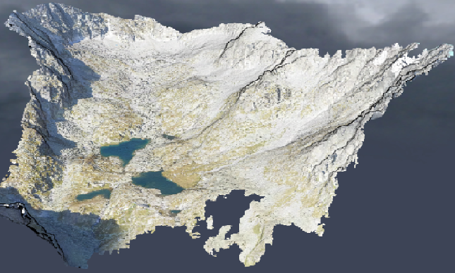
Webové 3D technológie umožňujú interaktívnu vizualizáciu a analýzu veľkých 3D mračien bodov. Elegantné riešene (webový nástroj) v tejto oblasti predstavil Ján Šašak (Univerzita Pavla Jozefa Šafárika v Košiciach), ktorý sa v spolupráci s kolegami (Michalom Gallayom, Jánom Kaňukom, Jaroslavom Hofierkom) z Ústavu geografie a prof. Jozefom Minárom z Univerzity Komenského vo svojom výskume venovali trojrozmernému mapovaniu alpínskeho reliéfu. […]
The post Webový nástroj slúžiaci pre mapovanie alpínskeho reliéfu appeared first on GISportal.cz.
Lokalizace opatření krajinotvorných programů
23.9.2019 2:00 Cenia - Katalog metadat ČR - INSPIRE Prostorová informace ke smlouvě uzavřené na realizaci opatření krajinotvorného programu; vrstva obsahuje jednoduché prvky (Singlepart Features); AOPK ČR, 2019CoreLogic Reports the Negative Equity Share Fell to 3.8% in the Second Quarter of 2019
21.9.2019 0:35 GISCafe.com Webcasts-Webinars In the second quarter of 2019, 151,000 residential properties regained equityThe average homeowner gained $4,900 in home equity during the last …
Drone Deliveries Coming Soon, as Wing Unveils Plans for First-of-its-Kind Trial with FedEx and Walgreens
21.9.2019 0:35 GISCafe.com Webcasts-Webinars Pilot program to launch in Virginia next month; Wing drones to transport select FedEx and Walgreens deliveries directly to homes through the airPALO …
RoboSense RS-LiDAR-M1 Smart LiDAR Sensor Wins AutoSens Awards 2019
21.9.2019 0:35 GISCafe.com Webcasts-Webinars BRUSSELS — (BUSINESS WIRE) — September 20, 2019 —On September 18, 2019, RoboSense announced at Brussels, Belgium that its …
15-Hour Flight Time - MMC UAV Launches New Record-Breaking Hydrone
21.9.2019 0:35 GISCafe.com Webcasts-Webinars SHENZHEN, China, Sept. 20, 2019 — (PRNewswire) — MMC UAV launched its new hydrone Griflion H, with a record-breaking 15-hour flight time …Singapore Land Transport Authority expand Kim Chuan Depot
20.9.2019 16:40 Bentley SystemsPress Coverage
BIM Today, UK
Read the articleCounting down to Digital Construction Week 2019
20.9.2019 16:38 Bentley SystemsPress Coverage
Builders Merchants Journal, UK
Read the article"We've been thinking about digital twins for a long time”
20.9.2019 16:34 Bentley SystemsPress Coverage
Infrastructure Intelligence, UK
Read the articleTeambuilding v Rakousku
20.9.2019 13:56 HrdličkaV pátek jsme odpoledne po alpské silnici Großglockner Hochalpenstraße dorazili do našeho horského hostince Wallackhaus, který leží v národním parku Vysoké Taury. Počasí nám přálo, a tak jen cesta sem byla díky krásným výhledům velkým zážitkem. V sobotu jsme se rozdělili na dvě skupiny a vyrazili na pěší túru pod nejvyšší horu našich jižních sousedů. První skupina si... View Article
The post Teambuilding v Rakousku appeared first on HRDLIČKA spol. s r.o. - komplexní služby v oblasti geodézie.
"Is Your County in Recession? A Growing Geographic Divide" by Stewart Berry
20.9.2019 13:03 GISCafe.com Webcasts-WebinarsExpertíza ESA pomáhá kosmické misi Spojených arabských emirátů
20.9.2019 11:01 Český Kosmický PortálPrvní kosmonaut ze Spojených arabských emirátů (SAE) Hazza Al Mansúrí je připravený letět na Mezinárodní kosmickou stanici. Zde bude mít podporu z nově vytvořeného řídicího střediska v Dubaji, kde se budou nacházet operátoři připravení ve spolupráci s ESA.
MyGalileoApp – targeting the future of mobility
20.9.2019 10:37 European GNSS Agency
Submissions in the MyGalileoApp competitions target applications in 11 innovation areas. European Mobility Week, which is taking place this week, is a good opportunity to take a look at some of the applications addressing mobility-related issues that were shortlisted in the Top 30 in this year’s edition of the competition.
The Smart Navigation and Infotainment innovation area was a popular choice in this year’s MyGalileoApp competition, with a total of six submissions. Of these, five target applications that aim to improve users’ mobility experience. For example, the Mob(ility) app aims to help different communities of pedestrians living in urban areas that need to have real-time accurate information of their environment to improve everyday mobility. The app will display the best route between two different points of the city depending on users’ preferences.
Streamlining urban traffic
Two applications in this year’s competition aim to streamline urban traffic flows. Firstly, the ReadyPark app makes it possible to exchange parking spots in real-time, by pairing users leaving a spot with users looking for one, which will improve the urban driving experience. Secondly, the Mylights application displays the remaining time of a red or green signal at a traffic light controlled junction and provides optimal speed recommendation (within the applicable speed limit) for drivers to arrive at the junction just in time for a green signal.
Read this: GSA, EIB sign agreement on investment in space
Another mobile application - Lycie - notifies drivers whenever a dangerous situation is detected, by monitoring both the driver and the road. Potential Lycie users include all drivers exposed to road traffic risks: employees or individuals in a car, bus, train or even on a motorbike.
However, it’s not only road transport solutions that were developed in this year’s competition – maritime transport was also targeted. Specifically, the GALILEONAUT application helps sailors to find their way inside a port or a marina. The solution provides a link between the harbour master's office and sailors and allows the harbour master to assign a docking place to a boat entering the harbour, and the sailor to be guided without requiring any assistance from the harbour master’s office.
Mapping, GIS and Agriculture
The Smart Navigation and Infotainment innovation area was not the only one to receive mobility-related submissions. In the Mapping, GIS and Agriculture areas too, some of the applications address specific mobility-related needs. For example, the RoadEO project makes use of a smartphone’s accelerometer, gyroscope, microphone, camera and of course GNSS module to record its environment while driving in a car, truck, bike or other mode of transport, and combines this with Earth observation data in a predictive analytics solution that advises road authorities about where and when road segments need to be maintained.
And this: GSA celebrates 1 billion Galileo smartphone users
In the agriculture segment, Tractor Navigator provides guidance for farmers driving tractors. It is a navigation app (like a car GPS) that enables users to visualise their current position and trajectory on an open field (no road). Using the app, farmers can also accurately follow a predefined trajectory with live feedback to correct deviations and record and load saved trajectories to pick up work from where they left off, thereby avoiding covering the same area twice.
Moving forward
Of the seven mobility related submissions reviewed here, three – Tractor Navigator, Ready Park and GALILEONAUT – have made it through to the final 10 projects selected for the second development phase of the competition. So stay tuned to see how they do!
Along with the other projects in the final 10, these three projects have until October 21 to deliver a finalised version of their app with 100% functionality. All teams that will successfully complete the second development phase will be invited to the finals, to be held in November 2019, where they will present their application to the GSA evaluation board. The awards will be decided after these presentations, with the first-place winner receiving a EUR 100,000 prize. The runner up and third place winners will receive EUR 50,000 and EUR 30,000 respectively.
Media note: This feature can be republished without charge provided the European GNSS Agency (GSA) is acknowledged as the source at the top or the bottom of the story. You must request permission before you use any of the photographs on the site. If you republish, we would be grateful if you could link back to the GSA website (http://www.gsa.europa.eu).
MyGalileoApp – targeting the future of mobility
20.9.2019 10:37 European GNSS AgencySubmissions in the MyGalileoApp competitions target applications in 11 innovation areas. European Mobility Week, which is taking place this week, is a good opportunity to take a look at some of the applications addressing mobility-related issues that were shortlisted in the Top 30 in this year’s edition of the competition.
The Smart Navigation and Infotainment innovation area was a popular choice in this year’s MyGalileoApp competition, with a total of six submissions. Of these, five target applications that aim to improve users’ mobility experience. For example, the Mob(ility) app aims to help different communities of pedestrians living in urban areas that need to have real-time accurate information of their environment to improve everyday mobility. The app will display the best route between two different points of the city depending on users’ preferences.
Streamlining urban traffic
Two applications in this year’s competition aim to streamline urban traffic flows. Firstly, the ReadyPark app makes it possible to exchange parking spots in real-time, by pairing users leaving a spot with users looking for one, which will improve the urban driving experience. Secondly, the Mylights application displays the remaining time of a red or green signal at a traffic light controlled junction and provides optimal speed recommendation (within the applicable speed limit) for drivers to arrive at the junction just in time for a green signal.
Read this: GSA, EIB sign agreement on investment in space
Another mobile application - Lycie - notifies drivers whenever a dangerous situation is detected, by monitoring both the driver and the road. Potential Lycie users include all drivers exposed to road traffic risks: employees or individuals in a car, bus, train or even on a motorbike.
However, it’s not only road transport solutions that were developed in this year’s competition – maritime transport was also targeted. Specifically, the GALILEONAUT application helps sailors to find their way inside a port or a marina. The solution provides a link between the harbour master's office and sailors and allows the harbour master to assign a docking place to a boat entering the harbour, and the sailor to be guided without requiring any assistance from the harbour master’s office.
Mapping, GIS and Agriculture
The Smart Navigation and Infotainment innovation area was not the only one to receive mobility-related submissions. In the Mapping, GIS and Agriculture areas too, some of the applications address specific mobility-related needs. For example, the RoadEO project makes use of a smartphone’s accelerometer, gyroscope, microphone, camera and of course GNSS module to record its environment while driving in a car, truck, bike or other mode of transport, and combines this with Earth observation data in a predictive analytics solution that advises road authorities about where and when road segments need to be maintained.
And this: GSA celebrates 1 billion Galileo smartphone users
In the agriculture segment, Tractor Navigator provides guidance for farmers driving tractors. It is a navigation app (like a car GPS) that enables users to visualise their current position and trajectory on an open field (no road). Using the app, farmers can also accurately follow a predefined trajectory with live feedback to correct deviations and record and load saved trajectories to pick up work from where they left off, thereby avoiding covering the same area twice.
Moving forward
Of the seven mobility related submissions reviewed here, three – Tractor Navigator, Ready Park and GALILEONAUT – have made it through to the final 10 projects selected for the second development phase of the competition. So stay tuned to see how they do!
Along with the other projects in the final 10, these three projects have until October 21 to deliver a finalised version of their app with 100% functionality. All teams that will successfully complete the second development phase will be invited to the finals, to be held in November 2019, where they will present their application to the GSA evaluation board. The awards will be decided after these presentations, with the first-place winner receiving a EUR 100,000 prize. The runner up and third place winners will receive EUR 50,000 and EUR 30,000 respectively.
Media note: This feature can be republished without charge provided the European GNSS Agency (GSA) is acknowledged as the source at the top or the bottom of the story. You must request permission before you use any of the photographs on the site. If you republish, we would be grateful if you could link back to the GSA website (http://www.gsa.europa.eu).
Změna úředních hodin - Kontaktní místo Dačice
20.9.2019 10:16 ČÚZK - předpisy a opatření Katastrální úřad pro Jihočeský kraj - Katastrální pracoviště Jindřichův Hradec zveřejnil novou aktualitu: UPOZORNĚNÍS účinností od 1.11.2019 budou úřední hodiny kontaktního místa Dačice omezeny na 1 den v týdnu a to pondělí: 8:00-12:00 a 13:00-17:00.
Změna úředních hodin - Kontaktní místo Dačice
20.9.2019 10:16 ČÚZK /Urady/Katastralni-urady/Katastralni-urady/Katastralni-urad-pro-Jihocesky-kraj/Katastralni-pracoviste/KP-Jindrichuv-Hradec/O-uradu/Aktuality/Zmena-urednich-hodin-Kontaktni-misto-DaciceZměna úředních hodin - Kontaktní místo Dačice
20.9.2019 10:16 ČÚZK - předpisy a opatření Katastrální úřad pro Jihočeský kraj - Katastrální pracoviště Jindřichův Hradec zveřejnil novou aktualitu: UPOZORNĚNÍS účinností od 1.10.2019 budou úřední hodiny kontaktního místa Dačice omezeny na 1 den v týdnu a to pondělí: 8:00-12:00 a 13:00-17:00.
Změna úředních hodin - Kontaktní místo Dačice
20.9.2019 10:13 ČÚZK - předpisy a opatření Katastrální úřad pro Jihočeský kraj zveřejnil novou aktualitu: UPOZORNĚNÍS účinností od 1.11.2019 budou úřední hodiny kontaktního místa Dačice omezeny na 1 den v týdnu a to pondělí: 8:00-12:00 a 13:00-17:00.
Změna úředních hodin - Kontaktní místo Dačice
20.9.2019 10:13 ČÚZK /Urady/Katastralni-urady/Katastralni-urady/Katastralni-urad-pro-Jihocesky-kraj/O-uradu/Aktuality/Zmena-urednich-hodin-Kontaktni-misto-DaciceEarth from Space
20.9.2019 10:05 ESA Observing the Earth
In this week's edition, discover Clarence Strait and part of Australia's Northern Territory with Copernicus Sentinel-2
Clarence Strait
20.9.2019 10:05 ESA Observing the Earth
Earth observation image of the week: Copernicus Sentinel-2 takes us over a narrow body of water in Australia’s Northern Territory
New maps of Earth from reflected satnav, invented at ESA
20.9.2019 8:48 ESA Navigation
Your phone or satnav receiver routinely picks up signals from navigation satellites in order to tell you precisely where you are. But have you ever thought what happens to those satnav signals afterwards? A foresighted ESA inventor had the idea of using them as a tool for observing the Earth.
New maps of Earth from reflected satnav, invented at ESA
20.9.2019 8:48 ESA NavigationYour phone or satnav receiver routinely picks up signals from navigation satellites in order to tell you precisely where you are. But have you ever thought what happens to those satnav signals afterwards? A foresighted ESA inventor had the idea of using them as a tool for observing the Earth.
New maps of Earth from reflected satnav, invented at ESA
20.9.2019 8:48 ESA Navigation
Your phone or satnav receiver routinely picks up signals from navigation satellites in order to tell you precisely where you are. But have you ever thought what happens to those satnav signals afterwards? A foresighted ESA inventor had the idea of using them as a tool for observing the Earth.
20190920 Vrchní referent / rada oddělení dokumentace KN
20.9.2019 8:38 ČÚZK - předpisy a opatření Katastrální úřad pro Středočeský kraj - Katastrální pracoviště Kladno Vyhlášení výběrového řízení: Vrchní referent / rada oddělení dokumentace KN V části "Úřední deska", v sekci "Oznámení a jiná úřední sdělení" bylo vystaveno "Oznámení o vyhlášení výběrového řízení na obsazení služebního místa Vrchní referent / rada oddělení dokumentace KN"20190920 Vrchní referent / rada oddělení dokumentace KN
20.9.2019 8:38 ČÚZK /Urady/Katastralni-urady/Katastralni-urady/Katastralni-urad-pro-Stredocesky-kraj/Katastralni-pracoviste/KP-Kladno/O-uradu/Aktuality/20190828-Odborny-rada-oddeleni-pravnich-vztahu-(1)Vrchní referent / rada oddělení dokumentace KN
20.9.2019 8:36 ČÚZK /Urady/Katastralni-urady/Katastralni-urady/Katastralni-urad-pro-Stredocesky-kraj/Uredni-deska/Oznameni-a-jina-uredni-sdeleni/Volna-mista/Vrchni-referent-rada-oddeleni-dokumentace-KNVrchní referent / rada oddělení dokumentace KN
20.9.2019 8:36 ČÚZK - volná místa Katastrální úřad pro Středočeský kraj - Katastrální pracoviště Kladno vypisuje výběrové řízení na místo Vrchní referent / rada oddělení dokumentace KNVrchní referent / rada oddělení dokumentace KN
20.9.2019 8:36 ČÚZK - předpisy a opatření Katastrální úřad pro Středočeský kraj - Katastrální pracoviště Kladnovypisuje výběrové řízení na místo Vrchní referent / rada oddělení dokumentace KN
Vrchní referent / rada oddělení dokumentace KN
Vodohospodářská opatření Bořislav
20.9.2019 0:00 Státní pozemkový úřad Státní pozemkový úřad, Krajský pozemkový úřad pro Ústecký kraj, Pobočka Teplice dokončila výstavbu vodohospodářských opatření v katastrálním území obce Bořislav, budovaných v rámci realizace komplexních pozemkových úprav. Opatření za 25 milionů korun se skládá ze dvou vodních nádrží, suchého poldru a sedmi přístupových cest, a je převážně financována z fondů EU – Programu rozvoje venkova. Celek je pak doplněn o pěší stezku a interakční prvek.Realizace polních cest C1 a C2 v katastrálním území Bílý Potok
20.9.2019 0:00 Státní pozemkový úřad Krajský pozemkový úřad pro Olomoucký kraj, Pobočka Jeseník vybudoval po dokončené komplexní pozemkové úpravě polní cesty C1 a C2, které byly navrženy plánem společných zařízení v katastrálním území Bílý Potok.Topcon introduces new technology advancements in inspection and monitoring
19.9.2019 19:32 GISCafe.com Webcasts-Webinars
Solutions designed to improve long-term structural health
STUTTGART, Germany – September 18, 2019 – Topcon …
25th INTERGEO: Industry is constantly growing / Solutions for future challenges facing our planet
19.9.2019 19:27 GISCafe.com Webcasts-Webinars After three successful days of EXPO and CONFERENCE, the 25th INTERGEO in Stuttgart has drawn to a close.Stuttgart/Karlsruhe, 19 September 2019. …
Quilt Data Introduces a Petabyte-Scale Data Portal for AWS
19.9.2019 18:50 GISCafe.com Webcasts-Webinars Company unlocks petabytes of cloud data, enabling organizations globally to discover and share unlimited public dataSAN FRANCISCO — (BUSINESS …
Kratos Receives $35 Million Sole-Source USAF IDIQ Contract for Subscale Aerial Target Spares
19.9.2019 18:50 GISCafe.com Webcasts-Webinars SAN DIEGO, Sept. 19, 2019 (GLOBE NEWSWIRE) -- Kratos Defense & Security Solutions, Inc. (Nasdaq:KTOS), a leading National Security Solutions …Luokung Technology Corp. Announces its to Provide PaaS service for the China's First Remote Sensing Big Data Cloud "SIWEI earth"
19.9.2019 18:50 GISCafe.com Webcasts-Webinars BEIJING, Sept. 19, 2019 — (PRNewswire) — Luokung Technology Corp. (NASDAQ: LKCO) ("Luokung" or the "Company"), one of the global …ProStar Geocorp Hires Peter Srajer as Chief GIS Scientist
19.9.2019 18:50 GISCafe.com Webcasts-Webinars GRAND JUNCTION, Colo. — (BUSINESS WIRE) — September 19, 2019 —ProStar Geocorp announced today that the company has hired Peter …
Tamr Launches Fall 2019 Data Unification System to Power Breakthrough Analytic Insights
19.9.2019 18:50 GISCafe.com Webcasts-Webinars Latest release supports AWS, Google Cloud and Microsoft Azure; Adds geospatial mapping and more to help enterprises unify and clean dirty …Hexagon Announces HxGN OnCall Public Safety Solutions Now Available on Microsoft Azure
19.9.2019 18:50 GISCafe.com Webcasts-Webinars New managed services deployment option delivers next-generation capabilities to public safety agencies of all sizesHUNTSVILLE, Ala., Sept. 19, 2019 …
TCS goIT Celebrates 10-Year Anniversary with New Micro Bit, GIS Technology Pathways and Digital Innovation Lab
19.9.2019 18:50 GISCafe.com Webcasts-Webinars Tata Consultancy Services' goIT, North America's Largest Industry Engagement Program for Computer Science Education, will also Add AI and IoT …Data is the key to help mitigate safety risks when planning FTTH and utility projects, says Gaist
19.9.2019 18:48 GISCafe.com Webcasts-Webinars Liverpool UK, 19 September 2019: The key to safe and secure widescale fibre deployment is extensive “digital twin” knowledge of the …GeoCue Group Hosts True View UAV LIDAR/Camera Sensor Demonstration Day in Davis, California
19.9.2019 18:47 GISCafe.com Webcasts-Webinars September 19, 2019 -- MADISON, AL – GeoCue Group will present a True View Demonstration Day in Davis, California with the partnership of …MWH Global Designs Water Recycling Plant: Australia’s First Water-Efficient Residential Community
19.9.2019 16:53 Bentley SystemsPress Coverage
Water Online, USA
Read the articleU.S. Infrastructure projects named as finalists in Bentley Systems’ Year in Infrastructure 2019 Awards
19.9.2019 16:48 Bentley SystemsPress Coverage
Hydrocarbon Processing, USA
Read the articleCase study: Digital Twin Pilot Demonstrator Project, Cambridge
19.9.2019 16:40 Bentley SystemsPress Coverage
BIM+, UK
Read the articleHexagon Announces HxGN OnCall Public Safety Solutions Now Available on Microsoft Azure
19.9.2019 16:01 Hexagon Safety & Infrastructure New managed services deployment option delivers next-generation capabilities to public safety agencies of all sizesHexagon Announces HxGN OnCall Public Safety Solutions Now Available on Microsoft Azure
19.9.2019 16:01 Hexagon Safety & Infrastructure New managed services deployment option delivers next-generation capabilities to public safety agencies of all sizesHexagon Announces HxGN OnCall Public Safety Solutions Now Available on Microsoft Azure
19.9.2019 16:01 Hexagon Safety & Infrastructure New managed services deployment option delivers next-generation capabilities to public safety agencies of all sizesAktualizace údajů
19.9.2019 14:24 Ústecký kraj V Geoportálu ÚAP Ústeckého kraje byla provedena aktualizace údajů pro poskytovatele Ředitelství silnic a dálnic ČR – jev 119 - Koncepce rozmístění odpočívek ŘSD.GSA funding opportunity: Enhanced GNSS Receiver/User Terminal
19.9.2019 11:54 European GNSS Agency
The European GNSS Agency (GSA) has opened a call for proposals within its Fundamental Elements funding mechanism, targeting the implementation of OS-NMA and/or I/NAV features in close-to-market receivers and/or GNSS user terminals. The deadline for submissions is 31 October 2019.
This Call for Proposals aims to implement OS-NMA and/or I/NAV improvements capability in close-to-market (i.e. min TRL 7) receivers and/or GNSS user terminals suitable for target application domains other than the Smart Tachograph.
The applicants are requested to propose a solution to reach this objective in such a way that:
- The receiver and/or terminal shall be able to receive and process OS-NMA and/or be fully compliant with and make optimal use of the new Galileo E1-OS I/NAV features introduced with the Galileo Open Service Interface Control Document (OS ICD).
- In case of OS-NMA implementation, the enhanced receiver and/or GNSS user terminal shall aim at optimising the level of protection at least against those spoofing attacks that are specific to the target application.
- The developed receiver and/or GNSS user terminal shall be cost efficient and compliant with the specific application constraints.
For more details, please see the call documentation package.
EGNSS differentiators: OS-NMA and I/NAV improvements
As part of its service portfolio, Galileo plans to provide a navigation message authentication feature over its Open Service (OS). From the Galileo standpoint, Navigation Message Authentication (NMA) is defined as the ability of the system to guarantee to users that they are utilising navigation data from the Galileo satellites and not from any other, potentially malicious, source.
In addition, with the same objective of enhancing the Galileo services portfolio, three new features will soon be provided free of charge to all Open Service users. These features will be gradually implemented from 2020 and will be openly accessible through the I/NAV message carried by the E1-B signal.
The OS-NMA feature is considered an important asset for the Galileo programme, being a strong technical differentiator with respect to the other GNSS. This capability will allow Galileo user terminals to assess the authenticity of the data provided through the Signal in Space transmitted by Galileo satellites against attempts to spoof it. It will also help improve the overall robustness of GNSS for various applications, particularly those for which security and trustworthiness are a priority. Furthermore, the OS-NMA will also offer a certain level of anti-replay capability. This capability will strictly depend on the measures implemented by the actual receiver and therefore cannot be considered a Galileo service.
The three new features, whilst ensuring full backward compatibility with existing Galileo receivers, will further improve the robustness of Galileo OS when retrieving the navigation data, particularly in challenging environments, and will enhance the Galileo OS capability to resolve users’ clock uncertainty. In this respect, a key performance metric (especially when GNSS operates in unassisted mode) is the time to receive Clock and Ephemeris Data (CED). Two of the newly introduced features contribute in different ways to improving the Time-To-CED, and therefore the overall Time to First Fix (TTFF).
Fundamental Elements call: at a glance
- Market segment: Transversal
- Deadline for submission of proposals: 31 October 2019
- Expected signature of contract: April to June 2020
- Maximum budget allocated: EUR 3 000 000
- Maximum number of projects: 2
- EU financing amount of each of the two projects: up to EUR 3 000 000 (70% co-funding)
- Webinar date: 9 October 2019 15:00
Webinar
On 9 October 2019 at 15:00, a webinar on the Fundamental Elements Call “Enhanced GNSS Receiver/User Terminal” will be held to provide applicants with information on how to prepare a proposal. To connect to the webinar click here.
Media note: This feature can be republished without charge provided the European GNSS Agency (GSA) is acknowledged as the source at the top or the bottom of the story. You must request permission before you use any of the photographs on the site. If you republish, we would be grateful if you could link back to the GSA website (http://www.gsa.europa.eu).
Podzimní termíny kurzů otevřeného software pro GIS od GISMentors (PR)
19.9.2019 9:05 GISportal.cz
Zpracování geodat v desktopové aplikaci QGIS, jejich uložení a sdílení v prostředí geodatabáze PostGIS a následná publikace pomocí mapového serveru GeoServer – to všechno se můžete naučit během podzima na veřejných kurzech GISMentors, které už pátým rokem pořádá firma OpenGeoLabs. Pro uživatele zabývající se pokročilejší analýzou dat je připraven kurz GRASS GIS a těm, kteří […]
The post Podzimní termíny kurzů otevřeného software pro GIS od GISMentors (PR) appeared first on GISportal.cz.
Výstava Pavel Aretin z Ehrenfeldu: mapa mezi defenestrací a Bílou horou dočasně nepřístupná [Knihovna geografie, byTopic]
19.9.2019 9:05 Katedra aplikované geoinformatiky a kartografie Přf UKBlue Marble’s Knight to speak at NSRS2022 Overview & Prospectives Workshop about the coming datum change
19.9.2019 9:00 GISCafe.com Webcasts-Webinars Hallowell, Maine – September 19, 2019 - Blue Marble Geographics (bluemarblegeo.com) is pleased to announce that it will be speaking at the …odborný referent – poskytování informací KN
19.9.2019 8:40 ČÚZK /Urady/Katastralni-urady/Katastralni-urady/Katastralni-urad-pro-hlavni-mesto-Prahu/O-uradu/Aktuality/bezpecnostni-technik-personalistaodborný referent – poskytování informací KN
19.9.2019 8:40 ČÚZK - předpisy a opatření Katastrální úřad pro hlavní město Prahu - Katastrální pracoviště Praha zveřejnil novou aktualitu: Ředitel úřadu vyhlašuje výběrové řízení na služební místo:odborný referent – poskytování informací KN
bezpečnostní technik - personalista
19.9.2019 8:40 ČÚZK /Urady/Katastralni-urady/Katastralni-urady/Katastralni-urad-pro-hlavni-mesto-Prahu/O-uradu/Aktuality/bezpecnostni-technik-personalistabezpečnostní technik - personalista
19.9.2019 8:40 ČÚZK - předpisy a opatření Katastrální úřad pro hlavní město Prahu zveřejnil novou aktualitu: Ředitel úřadu vyhlašuje výběrové řízení na služební místo:bezpečnostní technik - personalista
referent KN – vedení DKM, vedení katastrální mapy
19.9.2019 8:38 ČÚZK /Urady/Katastralni-urady/Katastralni-urady/Katastralni-urad-pro-hlavni-mesto-Prahu/O-uradu/Aktuality/referent-KN-–-vedeni-DKM,-vedeni-katastralni-mapyreferent KN – vedení DKM, vedení katastrální mapy
19.9.2019 8:38 ČÚZK - předpisy a opatření Katastrální úřad pro hlavní město Prahu zveřejnil novou aktualitu: Ředitel úřadu vyhlašuje výběrové řízení na služební místo:referent KN – vedení DKM, vedení katastrální mapy
referent KN – právník do právního oddělení XI.
19.9.2019 8:36 ČÚZK - předpisy a opatření Katastrální úřad pro hlavní město Prahu zveřejnil novou aktualitu: Ředitel úřadu vyhlašuje výběrové řízení na služební místo:referent KN – právník do právního oddělení XI.
referent KN – právník do právního oddělení XI.
19.9.2019 8:36 ČÚZK /Urady/Katastralni-urady/Katastralni-urady/Katastralni-urad-pro-hlavni-mesto-Prahu/O-uradu/Aktuality/referent-KN-–-pravnik-do-pravniho-oddeleni-XI-(1)Družice Sentinel-6A systému Copernicus je připravena na zkoušky
19.9.2019 8:32 Český Kosmický PortálDružice Sentinel-6A systému Copernicus je určená k měření globální hladiny moří. Nyní byla vybavena částí svého přístrojového vybavení a je připravena k testování, po němž by měl před koncem příštího roku následovat start do vesmíru.
Družice Sentinel-6A systému Copernicus je připravena na zkoušky
19.9.2019 8:32 Český Kosmický PortálDružice Sentinel-6A systému Copernicus je určená k měření globální hladiny moří. Nyní byla vybavena částí svého přístrojového vybavení a je připravena k testování, po němž by měl před koncem příštího roku následovat start do vesmíru.
bezpečnostní technik - personalista
19.9.2019 8:11 ČÚZK /Urady/Katastralni-urady/Katastralni-urady/Katastralni-urad-pro-hlavni-mesto-Prahu/Uredni-deska/Oznameni-a-jina-uredni-sdeleni/Volna-mista/bezpecnostni-technik-personalista-(1)bezpečnostní technik - personalista
19.9.2019 8:11 ČÚZK - předpisy a opatření Katastrální úřad pro hlavní město PrahuŘeditel úřadu vyhlašuje výběrové řízení na služební místo: bezpečnostní technik - personalista
bezpečnostní technik - personalista
bezpečnostní technik - personalista
19.9.2019 8:11 ČÚZK - volná místa Katastrální úřad pro hlavní město Prahu vypisuje výběrové řízení na místo bezpečnostní technik - personalistabezpečnostní technik - personalista
19.9.2019 8:11 ČÚZK - předpisy a opatření Katastrální úřad pro hlavní město Prahuvypisuje výběrové řízení na místo
bezpečnostní technik - personalista
referent KN – vedení DKM, vedení katastrální mapy
19.9.2019 8:07 ČÚZK - předpisy a opatření Katastrální úřad pro hlavní město Prahu - Katastrální pracoviště Prahavypisuje výběrové řízení na místo
referent KN – vedení DKM, vedení katastrální mapy
referent KN – vedení DKM, vedení katastrální mapy
19.9.2019 8:07 ČÚZK - volná místa Katastrální úřad pro hlavní město Prahu vypisuje výběrové řízení na místo referent KN – vedení DKM, vedení katastrální mapyreferent KN – vedení DKM, vedení katastrální mapy
19.9.2019 8:07 ČÚZK - předpisy a opatření Katastrální úřad pro hlavní město PrahuŘeditel úřadu vyhlašuje výběrové řízení na služební místo: referent KN – vedení DKM, vedení katastrální mapy
referent KN – vedení DKM, vedení katastrální mapy
referent KN – vedení DKM, vedení katastrální mapy
19.9.2019 8:07 ČÚZK /Urady/Katastralni-urady/Katastralni-urady/Katastralni-urad-pro-hlavni-mesto-Prahu/Uredni-deska/Oznameni-a-jina-uredni-sdeleni/Volna-mista/referent-KN-–-vedeni-DKM,-vedeni-katastralni-m-(1)referent KN – vedení DKM, vedení katastrální mapy
19.9.2019 8:07 ČÚZK - volná místa Katastrální úřad pro hlavní město Prahu - Katastrální pracoviště Praha vypisuje výběrové řízení na místo referent KN – vedení DKM, vedení katastrální mapyreferent KN – vedení DKM, vedení katastrální mapy
19.9.2019 8:07 ČÚZK - předpisy a opatření Katastrální úřad pro hlavní město Prahuvypisuje výběrové řízení na místo
referent KN – vedení DKM, vedení katastrální mapy
referent KN – právník do právního oddělení XI.
19.9.2019 8:03 ČÚZK - předpisy a opatření Katastrální úřad pro hlavní město PrahuŘeditel úřadu vyhlašuje výběrové řízení na služební místo: referent KN – právník do právního oddělení XI.
referent KN – právník do právního oddělení XI.
referent KN – právník do právního oddělení XI.
19.9.2019 8:03 ČÚZK - předpisy a opatření Katastrální úřad pro hlavní město Prahu - Katastrální pracoviště Prahavypisuje výběrové řízení na místo
referent KN – právník do právního oddělení XI.
referent KN – právník do právního oddělení XI.
19.9.2019 8:03 ČÚZK - předpisy a opatření Katastrální úřad pro hlavní město Prahuvypisuje výběrové řízení na místo
referent KN – právník do právního oddělení XI.
referent KN – právník do právního oddělení XI.
19.9.2019 8:03 ČÚZK - volná místa Katastrální úřad pro hlavní město Prahu - Katastrální pracoviště Praha vypisuje výběrové řízení na místo referent KN – právník do právního oddělení XI.referent KN – právník do právního oddělení XI.
19.9.2019 8:03 ČÚZK - volná místa Katastrální úřad pro hlavní město Prahu vypisuje výběrové řízení na místo referent KN – právník do právního oddělení XI.referent KN – právník do právního oddělení XI.
19.9.2019 8:03 ČÚZK /Urady/Katastralni-urady/Katastralni-urady/Katastralni-urad-pro-hlavni-mesto-Prahu/Uredni-deska/Oznameni-a-jina-uredni-sdeleni/Volna-mista/referent-KN-–-pravnik-do-pravniho-oddeleni-XI-(1)Hexagon Announces HxGN OnCall Public Safety Solutions Now Available on Microsoft Azure
19.9.2019 3:00 Hexagon Safety & InfrastructureToday, Hexagon’s Safety & Infrastructure division announced the availability of the HxGN OnCall portfolio of public safety solutions as a managed service offering deployed on Microsoft Azure. The new offering brings next-generation public safety technologies to agencies of all sizes by lowering the total cost of ownership and enabling faster deployments with reduced resources and capital expenditure.
Deployable on-premises or in the cloud, HxGN OnCall is a comprehensive, cohesive portfolio of public safety solutions. Its capabilities span dispatch, records, analytics and more. The portfolio leverages data and analytics, enabling public safety agencies to enhance operational awareness, increase efficiency and optimize resources. By deploying HxGN OnCall on Azure, agencies of all sizes can take advantage of enterprise-level capabilities with system enhancements and features that remain continually up-to-date.
“Today, public safety agencies must adapt their systems to keep up with rapidly changing demands, and accelerating IT cycles are making it increasingly expensive to maintain current environments, particularly for smaller agencies,” said Kalyn Sims, CTO of Hexagon’s Safety & Infrastructure division. “This combination drains IT department resources, holding agencies back from implementing the new technologies they need and that the public expects. The new managed service option, available on Microsoft Azure, allows agencies of all sizes to cost-effectively keep up with the ever-changing requirements in the dynamic public safety environment.”
Stuart McKee, National Technology Officer, Microsoft Corp., said, “As public safety agencies are facing new challenges and limited resources, they are moving critical services to the cloud. Agencies need technologies and partners they can trust to help them adapt and move forward. Hexagon and Microsoft provide the expertise, security and experience agencies need to transition to the cloud effectively and efficiently.”
The new managed service offering is available for HxGN OnCall Dispatch, HxGN OnCall Analytics and HxGN OnCall Records. These solutions include a robust feature set and an exceptional user experience informed by nearly three decades of experience and hundreds of scientific research studies with call-takers and dispatchers from around the world.
To learn more about the new managed service offering for HxGN OnCall, visit www.hexagonsafetyinfrastructure.com/managedservice.
Ložiska nerostných surovin a prognózní zdroje
19.9.2019 2:00 Cenia - Katalog metadat ČR - INSPIRE Databáze obsahuje údaje o výhradních ložiscích, ložiscích nevyhrazených nerostů prognózních zdrojích, ložiskách a zdrojích s ukončenou těžbou, ložiskově neperspektivních oblastech, výsledcích negativních průzkumů a geografickou lokalizaci ložisek.CoreLogic Integrates Geospatial Insurance Consortium (GIC) Imagery Into Underwriting Platform
18.9.2019 20:13 GISCafe.com Webcasts-Webinars Access to current, advanced aerial imagery offers comprehensive property assessment virtually and improved catastrophe response for insurance …LeddarTech Exhibiting and Presenting at a Series of Conferences on Automotive and Mobility LiDAR Technology this Fall
18.9.2019 20:13 GISCafe.com Webcasts-Webinars QUEBEC CITY, Sept. 18, 2019 (GLOBE NEWSWIRE) -- LeddarTech®, an industry leader in LiDAR technology providing the most versatile and scalable auto …Datumate and Dorsch Group Announce Strategic Partnership
18.9.2019 20:13 GISCafe.com Webcasts-Webinars YOKNEAM, Israel, and FRANKFURT, Germany, Sept. 18, 2019 — (PRNewswire) — Datumate and Dorsch Group are pleased to announce today that …Trimble to Host its 2020 in.sight user conference + expo in Orlando
18.9.2019 20:13 GISCafe.com Webcasts-Webinars HOUSTON, Sept. 18, 2019 — (PRNewswire) — Trimble (NASDAQ: TRMB) announced today that its 2020 in.sight user conference + expo will …Hemisphere GNSS Announces Next-Generation S621 GNSS Survey Smart Antenna
18.9.2019 20:13 GISCafe.com Webcasts-Webinars The first GNSS survey smart antenna using next-generation ASIC technology to deliver best-in-class, industry-leading performance and precisionMIAMI, …
WhiteFox Completes Successful Series A Funding
18.9.2019 20:13 GISCafe.com Webcasts-Webinars Drone airspace security leader raises additional $12M to fuel product expansionSAN LUIS OBISPO, Calif., Sept. 18, 2019 — (PRNewswire) — …
A digital replica for Hong Kong Science Park
18.9.2019 17:11 Bentley SystemsPress Coverage
BIM Today, UK
Read the articleGSA webinars on Pre-Commercial Procurement funding opportunities tailored to public authorities
18.9.2019 16:56 European GNSS Agency
In September 2019, public authorities will have the opportunity to attend and participate in several informative webinars on Pre-Commercial Procurement and learn about the available funding opportunities on this topic.
In September 2019 public authorities and research institutions will have the opportunity to attend and participate in a number of informative webinars on PCP: Pre-Commercial Procurement. Pre-Commercial Procurement is the new innovative procurement tool for Galileo applications R&D tailored to public authorities.
Participants in these webinars will have the opportunity to:
- Discuss innovation areas in EGNSS downstream applications from which public authorities can benefit;
- Learn about the general Pre-Commercial Procurement concept, along with its participation rules and conditions;
- Find out about the upcoming funding opportunities on this topic.
The specific webinars are as follows:
- 23 September at 10.30-11.30 am CEST: Maritime
- 26 September at 15:00-16:00 pm CEST: Rail
- 27 September at 10:00-11:00 am CEST: Aviation
- 30 September at 15:00-16:00 pm CEST: Timing & Synchronisation
You can also find information on workshops held earlier this year on ‘EGNSS Innovation procurement opportunities within Horizon 2020 and Horizon Europe’ here and here.
Media note: This feature can be republished without charge provided the European GNSS Agency (GSA) is acknowledged as the source at the top or the bottom of the story. You must request permission before you use any of the photographs on the site. If you republish, we would be grateful if you could link back to the GSA website (http://www.gsa.europa.eu).
GSA webinars on Pre-Commercial Procurement funding opportunities tailored to public authorities
18.9.2019 16:56 European GNSS AgencyIn September 2019, public authorities will have the opportunity to attend and participate in several informative webinars on Pre-Commercial Procurement and learn about the available funding opportunities on this topic.
In September 2019 public authorities and research institutions will have the opportunity to attend and participate in a number of informative webinars on PCP: Pre-Commercial Procurement. Pre-Commercial Procurement is the new innovative procurement tool for Galileo applications R&D tailored to public authorities.
Participants in these webinars will have the opportunity to:
- Discuss innovation areas in EGNSS downstream applications from which public authorities can benefit;
- Learn about the general Pre-Commercial Procurement concept, along with its participation rules and conditions;
- Find out about the upcoming funding opportunities on this topic.
The specific webinars are as follows:
- 23 September at 10.30-11.30 am CEST: Maritime. Link to webinar.
- 26 September at 15:00-16:00 pm CEST: Rail. Link to webinar.
- 27 September at 10:00-11:00 am CEST: Aviation. Link to webinar.
- 30 September at 15:00-16:00 pm CEST: Timing & Synchronisation. Link to webinar.
You can also find information on workshops held earlier this year on ‘EGNSS Innovation procurement opportunities within Horizon 2020 and Horizon Europe’ here and here.
Media note: This feature can be republished without charge provided the European GNSS Agency (GSA) is acknowledged as the source at the top or the bottom of the story. You must request permission before you use any of the photographs on the site. If you republish, we would be grateful if you could link back to the GSA website (http://www.gsa.europa.eu).
Counting down to ‘biggest ever’ Digital Construction Week 2019
18.9.2019 16:52 Bentley SystemsPress Coverage
Construction UK Magazine, UK
Read the articleQuantifying risks and planning resilience measures
18.9.2019 16:46 Bentley SystemsPress Coverage
Stormwater Management, UK
Read the articleDigital Twin Advancements for Asset Performance
18.9.2019 16:39 Bentley SystemsPress Coverage
ReliabilityWeb, USA
Read the articleAirbus announces new and expanded capabilities for OceanFinder
18.9.2019 15:30 GISCafe.com Webcasts-Webinars Near-real time vessel identification and route prediction @AirbusSpace #OceanFinder #AIS Toulouse, 18 September 2019 – Airbus …