


![]()

zprávy
zdroje zpráv:Využijte naší nabídky školení také na podzim
2.10.2019 9:49 ARCDATAV nabídce našich školení do konce roku naleznete ještě celou řadu oblíbených kurzů, jejichž absolvováním můžete získat nové znalosti pro desktopové, webové i serverové aplikace.

Úplnou nabídku včetně veškerých informací naleznete na stránkách Školení.
Podrobný program BIM Day 2019. Konference se koná již 8. října
2.10.2019 9:17 GeoBusiness Pořadatelé uveřejnili podrobný program letošního ročníku konference BIM Day 2019, kterou každoročně na podzim pořádá Odborná rada pro BIM. Registrovat se můžete přímo na ... PřečístPodrobný program BIM Day 2019. Konference se koná již 8. října
2.10.2019 9:17 GeoBusiness Pořadatelé uveřejnili podrobný program letošního ročníku konference BIM Day 2019, kterou každoročně na podzim pořádá Odborná rada pro BIM. Registrovat se můžete přímo na webu konference. Pro zájemce o účast z řad členů Asociace podnikatelů v geomatice je navíc připraveno výhodnější vložné. V případě svého zájmu kontaktujte sekretariát APG. Aktuální dění v BIM a situace […]Sanjay Gangal interviews Michael Sitar from Teledyne Optech at Intergeo 2019 CONFERENCE
2.10.2019 9:00 GISCafe.com Webcasts-WebinarsControl Point Associates, Inc. expands its GIS division with the addition of Dawn F. McCall
2.10.2019 9:00 GISCafe.com Webcasts-Webinars WARREN, N.J., Oct. 1, 2019 — (PRNewswire) — Control Point Associates, Inc. has announced that Dawn F. McCall, GISP has joined the firm …Kde je Wolkerák nebo Rušička? Pojďte s námi mapovat Liberec (TZ)
2.10.2019 8:40 GISportal.cz
Hokejka, Wolkerák, Tajch, Rušička – místa a jejich jména, která jistě zná každý Liberečan. Názvy, které se běžně používají, a přesto je v žádné mapě nenajdete. To je důvod, proč vznikl projekt s názvem Živá jména. Jeho cílem je sebrat taková jména, která slouží Liberečanům k orientaci v jejich městě. Za projektem stojí Daniel Vrbík a Václav Lábus z Fakulty […]
The post Kde je Wolkerák nebo Rušička? Pojďte s námi mapovat Liberec (TZ) appeared first on GISportal.cz.
GISchat v ArcData Praha
2.10.2019 7:48 Katedra geoinformatiky UP OlomoucArcData Praha nabízí všem studentům konzultace u svých odborníků na akci GISchat. Využijte této příležitosti a získejte nový pohled na svou bakalářku, diplomku nebo i semestrálku. Akce se uskuteční 22. listopadu 2019 v sídle společnosti. Více informací naleznete na webových stránkách akce https://www.arcdata.cz/zpravy-a-akce/akce/gischat
The post GISchat v ArcData Praha appeared first on Katedra geoinformatiky.
OGC and STAC invite developers to Sprint to advance OGC APIs for Features and Catalogues
2.10.2019 1:10 GISCafe.com Webcasts-Webinars Developers at the ‘2019 OGC API - Features and Catalogues Sprint’ will work on Query and Filter reusable components to standardize …Uganda enables a sustainable future with geoscience data
2.10.2019 1:05 GISCafe.com Webcasts-Webinars Geosoft, a Canadian subsidiary of multinational Seequent, together with a global consortium, deliver on a key project to help support a …
Uganda enables a sustainable future with geoscience data
2.10.2019 1:05 GISCafe.com Webcasts-Webinars Geosoft, a Canadian subsidiary of multinational Seequent, together with a global consortium, deliver on a key project to help support a sustainable …Matternet's Technology Enabling First FAA-Approved Drone Airline
2.10.2019 0:08 GISCafe.com Webcasts-Webinars Part 135 Standard certification allows UPS and Matternet to rapidly scale drone delivery hospital operations in the U.S.MOUNTAIN VIEW, Calif., Oct. …
Státní pozemkový úřad zahájil 13. ročník soutěže Žít krajinou
2.10.2019 0:00 Státní pozemkový úřad Praha, 2. října 2019 – Soutěž zaměřenou na komplexní pozemkové úpravy pořádá Státní pozemkový úřad (SPÚ) ve spolupráci s Českomoravskou komorou pro pozemkové úpravy (ČMKPÚ) již od roku 2006. Krajské pobočky SPÚ, projektanti, stavitelé nebo obce či vlastníci realizované stavby mohou své projekty přihlásit do 30. listopadu 2019. Soutěž podporuje projekty, které svým charakterem splňují požadavky na celkové řešení krajiny nebo její části. Přihlásit lze takové projekty, které byly dokončeny nejpozději 31. prosince 2018.Crunching the Numbers: Australian software company helps City of Richmond deal with massive point cloud data problem
1.10.2019 19:18 GISCafe.com Webcasts-Webinars Crunching the NumbersNew software solution lets municipality handle massive volumes of Lidar data, improving dike inspection process and …
Elastic Releases Elastic Stack 7.4.0
1.10.2019 19:16 GISCafe.com Webcasts-Webinars Featuring new machine learning models, snapshot lifecycle management, cyber attack maps for Elastic SIEM, and moreMOUNTAIN VIEW, Calif. & …
Esri Releases ArcGIS QuickCapture, a One-Touch Field Data Collection Application
1.10.2019 19:15 GISCafe.com Webcasts-Webinars New App Gives Field Crews a Fast, Easy Way to Record Information While MobileREDLANDS, Calif. — (BUSINESS WIRE) — October 1, 2019 …
CoreLogic Reports August Home Prices Increased by 3.6% Year Over Year
1.10.2019 19:15 GISCafe.com Webcasts-Webinars The CoreLogic HPI Forecast indicates annual price growth will increase 5.8% by August 2020About three-fourths of millennial renters indicate they …
Second Sight Announces $2.4 Million, Four-Year Grant from National Institutes of Health to Develop Spatial Localization and Mapping Technology
1.10.2019 19:15 GISCafe.com Webcasts-Webinars Initiative a Joint Collaboration with the John Hopkins University Applied Physics LaboratoryLOS ANGELES — (BUSINESS WIRE) — October 1, …
Kratos Receives $17.6 Million Sole-Source Contract Award for New Tactical Jet Drone System Research, Development and Initial Production
1.10.2019 19:15 GISCafe.com Webcasts-Webinars SAN DIEGO, Oct. 01, 2019 (GLOBE NEWSWIRE) -- Kratos Defense & Security Solutions, Inc. (Nasdaq:KTOS), a leading National Security Solutions …Cellular-connected Drones to Deliver Life-saving Emergency Defibrillators Following Ground-breaking Canadian Trial
1.10.2019 19:15 GISCafe.com Webcasts-Webinars The County of Renfrew in Ontario, Canada is working in partnership with InDro Robotics, Cradlepoint and Ericsson to reduce time to treatment in …4. aktualizace ZÚR JČK ve verzi pro společné jednání
1.10.2019 18:50 Jihočeský kraj Do sekce 4. aktualizace ZÚR Jihočeského kraje byla vložena 4. aktualizace Zásad územního rozvoje Jihočeského kraje ve verzi pro společné jednání a zveřejnění návrhu dle § 37 odst. 3 stavebního zákona.Amery berg
1.10.2019 17:06 ESA Observing the Earth
A massive iceberg breaks off the Amery Ice Shelf in Antarctica, as captured by Copernicus Sentinel-1
20191001 - Změny VFK v nové verzi ISKN 9.0
1.10.2019 15:17 ČÚZK - Výměnný formát ISKN V souvislosti s instalací nové verze ISKN 9.0 dojde k rozšíření obsahu změnových exportů VFK s omezující podmínkou k.ú. obsahující pseudonymizované záznamy oprávněných subjektů (OS). Předpokládaný termín instalace je 29. 10. 2019.20191001 - Změny VFK v nové verzi ISKN 9.0
1.10.2019 15:17 ČÚZK - Výměnný formát ISKN V souvislosti s instalací nové verze ISKN 9.0 dojde k rozšíření obsahu změnových exportů VFK s omezující podmínkou k.ú. obsahující pseudonymizované záznamy oprávněných subjektů (OS). Popis plánovaných změn je uveden v samostatném dokumentu.Předpokládaný termín instalace je 29. 10. 2019.
Hackathon s Lékaři bez hranic v Plzni
1.10.2019 14:09 GISportal.cz
O víkendu 11. – 13. října se v Plzni uskuteční úplně první hackathon Missing Maps v Česku. Česká a slovenská komunita dobrovolníků dělá skvělou práci na mapathonech, ale teď chceme společně posunout mapování na novou úrvoveň. Takže pokud jste vývojáři, gisáci, ux/ui a další specialisté neváhejte se přihlásit. Výzvy Detekce mraků na satelitních snímcích Nástroj […]
The post Hackathon s Lékaři bez hranic v Plzni appeared first on GISportal.cz.
Hlavní motor Ariane 6 dokončil kvalifikační testy
1.10.2019 13:17 Český Kosmický PortálRaketa Ariane 6, která je evropským kosmickým nosičem příští generace, dosáhla dalšího vývojového mezníku. Její motor Vulcain 2.1 na kapalné pohonné látky dokončil kvalifikační testy. To znamená, že nyní může podstoupit kombinované zkoušky.
GEFOS se podílí na novém mostu přes Dunaj v rakouském Linci
1.10.2019 13:00 ZeměměřičFirma GEFOS oznámila, že v září 2019 získala zakázku na zajištění geodetických prací při montáži ocelové konstrukce nového mostu přes Dunaj v Linci. Jde o tvarově náročnou konstrukci mostu 400 metrů dlouhého a více jak 33 metrů širokého. Generálním dodavatelem mostu je linecká společnost MCE GmbH, na dodávkách prací se podílí jejich dceřinná společnost MCE Slaný. Most (Neue Donaubrücke Linz) […]
The post GEFOS se podílí na novém mostu přes Dunaj v rakouském Linci appeared first on Zeměměřič.
ESA leads drive into our 5G positioning future
1.10.2019 12:17 ESA Navigation
A pair of testbed vehicles went out on the road in Germany to simulate the way we are all likely to be using 5G positioning services in the future. The field test focused on assessing the performance of highly-precise ‘hybrid’ satellite/terrestrial positioning for autonomous vehicles, drones, smart cities and the Internet of Things.
ESA leads drive into our 5G positioning future
1.10.2019 12:17 ESA NavigationA pair of testbed vehicles went out on the road in Germany to simulate the way we are all likely to be using 5G positioning services in the future. The field test focused on assessing the performance of highly-precise ‘hybrid’ satellite/terrestrial positioning for autonomous vehicles, drones, smart cities and the Internet of Things.
ESA leads drive into our 5G positioning future
1.10.2019 12:17 ESA Navigation
A pair of testbed vehicles went out on the road in Germany to simulate the way we are all likely to be using 5G positioning services in the future. The field test focused on assessing the performance of highly-precise ‘hybrid’ satellite/terrestrial positioning for autonomous vehicles, drones, smart cities and the Internet of Things.
Taking Digital to the High Seas
1.10.2019 12:15 GISCafe.com Webcasts-Webinars CAMBRIDGE, MA—Sept. 30, 2019 — When GPS isn’t available to pinpoint location, wearable technologies that rely on this …Přerušení provozu DP a WSDP v sobotu 5.10.2019 od 8:00 až do cca 18:00.
1.10.2019 10:31 ČÚZK /Aplikace-DP-do-KN/Aplikace-DP-do-KN/Archiv-DP/269089Přerušení provozu DP a WSDP v sobotu 5.10.2019 od 8:00 až do cca 18:00.
1.10.2019 10:31 Dálkový přístup k údajům KN ČR Vážení uživatelé,oznamujeme, že v sobotu 5.10.2019 od 8:00 bude z provozních důvodů zcela přerušen provoz Dálkového přístupu i Webových služeb dálkového přístupu. Obnovení provozu předpokládáme v cca 18:00 hodin.
Za komplikace tímto způsobené se omlouváme a děkujeme za pochopení.
Přerušení provozu DP a WSDP v sobotu 5.10.2019 od 8:00 až do cca 18:00.
1.10.2019 10:31 ČÚZK - předpisy a opatření Vážení uživatelé,oznamujeme, že v sobotu 5.10.2019 od 8:00 bude z provozních důvodů zcela přerušen provoz Dálkového přístupu i Webových služeb dálkového přístupu. Obnovení provozu předpokládáme v cca 18:00 hodin.
Za komplikace tímto způsobené se omlouváme a děkujeme za pochopení.
Trimble GIS Express již příští týden!
1.10.2019 9:26 Geotronics GIS - Trimble GIS Express startuje. Nezapomeňte se zaregistrovat!Sanjay Gangal interviews James Van Rens from RIEGL at Intergeo 2019 CONFERENCE
1.10.2019 9:00 GISCafe.com Webcasts-WebinarsSOLV3D Releases New Data Export Feature for SOLV3D encompass
1.10.2019 9:00 GISCafe.com Webcasts-Webinars CALGARY, AB – September 30, 2019 – SOLV3D, a leading provider of 3D processing, geospatial data visualization and collaboration …
Zoznam stavieb
1.10.2019 9:00
ÚGKK SR
ÚGKK SR v zmysle § 20a ods. 2 a 3 zákona NR SR č. 215/1995 Z. z. o geodézii a kartografii sprístupnil aplikáciu pre obce na zber vybraných údajov o stavbách.
Usmernenie č. USM_UGKK SR_10/2019
1.10.2019 8:45
ÚGKK SR
Usmernenie ÚGKK SR č. USM_UGKK SR_10/2019, zo dňa 20. 09. 2019, ktorým sa ustanovuje postup pri vydávaní preukazu geodeta
Aktualizace dat v mapových aplikacích
1.10.2019 7:30 Jihočeský kraj Mapová aplikace Technická infrastruktura a mapová aplikace Zastavěné území byly aktualizovány k 30.9.2019.Oznámení o vložení nové nabídky do Nabídky pronájmu domů a bytů k bydlení
1.10.2019 0:00 Státní pozemkový úřad Na webových stránkách byla vložena nová nabídka typu Nabídky pronájmu domů a bytů k bydlení, která je dostupná od 01.10.2019Seminář Pozemkové úpravy okres Nymburk
1.10.2019 0:00 Státní pozemkový úřad Dovolujeme si vás pozvat na seminář Pozemkové úpravy okres Nymburk, který se uskuteční 8. října 2019 od 9.00 hodin v hotelu Na farmě Choťovice.Cílem semináře je přiblížit účastníkům přípravu a realizaci pozemkových úprav a jejich přínos pro obec i krajinu. Seminář a následná exkurze se uskuteční v lokalitě, kde jsou pozemkové úpravy aktuálně realizovány. V rámci semináře budou účastníci seznámeni se zkušenostmi jednotlivých vystupujících s operací 4.3.1 Pozemkové úpravy Programu rozvoje venkova 2014-2020.
Účast na semináři je BEZPLATNÁ. Drobné občerstvení a oběd jsou hrazeny Celostátní sítí pro venkov.
Kontaktní osoba: Mgr. Miroslav Prokop, tel.: 735 764 266. Rezervace místa na semináři (přihlášky) zašlete prostřednictvím e-mailu:miroslav.prokop@szif.cz nejpozději do 6. 10. 2019
Výzva k podání návrhu - Radouňka
1.10.2019 0:00 Státní pozemkový úřad SPÚ vyhlašuje výzvu k podání návrhů na uzavření pachtovní smlouvy - kú RadouňkaVýběrové řízení pro vyjíždějící Erasmus+ studenty a akademické pracovníky v jarním semestru 2020
1.10.2019 0:00 Geografický ústav MUNa Geografickém ústavu bylo otevřeno:
- 3. kolo výběrového řízení pro vyjíždějící Erasmus+ studenty v jarním semestru 2020.
Přihlášky do výběrového řízení podávejte do 1. ŘÍJNA 2019, a to elektronicky prostřednictvím systému ISOIS na adrese https://isois.ois.muni.cz/public/application-outgoing/.
Akceptovány budou pouze úplné přihlášky včetně příloh. - 2. kolo výběrového řízení na výukové pobyty v rámci programu Erasmus+
Termín pro podání přihlášek je do 22. ZÁŘÍ 2019. Detailní informace týkající se výukových mobilit najdete na https://czs.muni.cz/cs/pracovnik-mu/vyukovepobyty/erasmus-evropa
Podrobnější informace k výběrovému řízení a seznam univerzit zapojených do programu naleznete na webu http://geogr.muni.cz/program-erasmus. V případě dotazů kontaktujte oborové koordinátory dr. Burianovou nebo dr. Lásku.
Seminář Pozemkové úpravy okres Nymburk
1.10.2019 0:00 Státní pozemkový úřad Dovolujeme si vás pozvat na seminář Pozemkové úpravy okres Nymburk, který se uskuteční 8. října 2019 od 9.00 hodin v hotelu Na farmě Choťovice.Cílem semináře je přiblížit účastníkům přípravu a realizaci pozemkových úprav a jejich přínos pro obec i krajinu. Seminář a následná exkurze se uskuteční v lokalitě, kde jsou pozemkové úpravy aktuálně realizovány. V rámci semináře budou účastníci seznámeni se zkušenostmi jednotlivých vystupujících s operací 4.3.1 Pozemkové úpravy Programu rozvoje venkova 2014-2020.
Účast na semináři je BEZPLATNÁ. Drobné občerstvení a oběd jsou hrazeny Celostátní sítí pro venkov.
Kontaktní osoba: Mgr. Miroslav Prokop, tel.: 735 764 266. Rezervace místa na semináři (přihlášky) zašlete prostřednictvím e-mailu:miroslav.prokop@szif.cz nejpozději do 6. 10. 2019
Utilis Joins Esri Partner Network, Bringing Improved Satellite Analytics to North American Customers
30.9.2019 23:23 GISCafe.com Webcasts-Webinars Partnership Gives Water Utility Assessment Firm a Geospatial AdvantageSAN DIEGO, Sept. 30, 2019 — (PRNewswire) —
SAN DIEGO, Sept. 30, …
Carlson Software Leads Competition in All Metrics
30.9.2019 21:17 Carlson Software MAYSVILLE, Kentucky, USA (September 2019) – Just as Carlson Software 2020 products are being released (carlsonsw.com/2020), those civil engineers and land surveyors thinking of upgrading their software might take note of the recent Clear Seas Research annual report. The report noted that for CAD software, “Carlson outperforms all competitors across every tested metric.” These metrics […]OGC announces exciting agenda for two-day Location Powers: Data Science summit
30.9.2019 20:41 GISCafe.com Webcasts-Webinars Location Powers: Data Science will be held 13-14 Nov at Google’s Crittenden Campus in Mountain View, CAContact: …
Time to Upgrade?… No Problem
30.9.2019 20:16 Carlson Software Carlson Survey and Civil 2020 have just been released! For those of you on maintenance (a very good cost-saving practice), you now have the opportunity to upgrade to the latest release of Carlson Software with no additional cost. All of the new features and capabilities of Carlson are just there waiting for you to take […]Carlson Survey and GIS 2020 offer User Interface Upgrades, Efficiency Tools and Education
30.9.2019 20:02 Carlson Software UPDATE (October 2019) — Carlson Survey 2020 OEM is now released (download available here). This version of the United States’ leading office software solution for surveyors contains an AutoCAD® 2018 OEM engine built-in. This gives users the capability to run Carlson’s popular survey commands natively in the current AutoCAD DWG-drawing file format. MAYSVILLE, Kentucky, USA […]Carlson Survey and GIS 2020 offer User Interface Upgrades, Efficiency Tools and Education
30.9.2019 20:02 Carlson Software MAYSVILLE, Kentucky, USA (September 2019) — Carlson’s latest release of Survey 2020 brings intuitive UI upgrades along with a host of new features and tools to improve day-to-day efficiency. A long-anticipated Migration Wizard for upgrading software as well as sharing settings and files across the office highlights this year’s list of customer-centric updates. This new […]Carlson Mining 2020 Features Upgrades, New Tools, and Functionality Enhancements
30.9.2019 19:37 Carlson Software MAYSVILLE, Kentucky, U.S.A. (September 2019) — Carlson Mining 2020 is available now and features upgrades to existing options, new tools, and functionality enhancements. Mining 2020 includes the modules Geology, Surface Mining, and Underground Mining. Carlson Mining 2020 is able to run on AutoCAD® 2015-2020 and comes with IntelliCAD 9.2. “Carlson Mining 2020 provides dozens of […]More Dynamic, Carlson Civil and Hydrology 2020 Provide Advanced New Features
30.9.2019 18:41 Carlson Software MAYSVILLE, Kentucky, USA (September 2019)– Carlson’s latest release of Civil and Hydrology 2020 brings intuitive UI upgrades that provide a more dynamic work experience along with advanced new features including improved surface model and pipe network design. The upgraded TIN creation and editing utilities are now much more dynamic in their operation. Users can easily […]SpatialTEQ Inc. Releases Map Business Online Pro - Map-based Market Analysis for Business
30.9.2019 16:47 GISCafe.com Webcasts-Webinars CORNISH, Maine, Sept. 30, 2019 — (PRNewswire) — SpatialTEQ Inc., publisher of North America's leading business mapping software, …Hlavní přednášející a program letošní konference GIS Esri v ČR
30.9.2019 15:00 GeoBusiness Konference GIS Esri více než dvacet pět let seznamuje účastníky s novinkami v oblasti GIS a s aktuálními projekty ve veřejném i privátním sektoru. Pořadatelé se snaží vždy namíchat ten správný koktejl přednášek - témata jdou od veřejné správy na krajské i místní úrovni přes správu inženýrských sítí až po přírodní vědy, dálkový průzkum Země nebo kartografii. Specializované workshopy informují o technologických novinkách a ukazují doporučené pracovní postupy pro práci se softwarem ArcGIS. Součástí konference jsou také soutěže, tematické expozice či výstava posterů a velkoformátových tisků kartografické produkce.Ocenění studenta Ladislava Semráda
30.9.2019 14:28 Geografický ústav MUStudent Geografického ústavu PřF MU Ladislav Semrád získal cenu za 3. nejlepší poster (Poruchy barvocitu a mapy pro orientační běh) na 23. kartografické konferenci.
Informace z konference: https://gisportal.cz/23-kartograficka-konference-je-za-nami
Daruj krev s KGI
30.9.2019 13:35 Katedra geoinformatiky UP OlomoucStudenti, absolventi, kolegové, stejně jako vloni se i letos ve středu (23. 10. v 9:00) v rámci POOLu uskuteční „Daruj krev s KGI“, tj. hromadné bezplatné darování krve ve FNOL. Následný program (doktorandský den) je záměrně až na 11.00, takže stíháme. Pokud někdo uvažuje o dárcovství a zatím se neodhodlal, chce udělat dobrý skutek nebo […]
The post Daruj krev s KGI appeared first on Katedra geoinformatiky.
Odborný referent / vrchní referent v oddělení aktualizace KN č. 2 na Katastrálním pracovišti Znojmo
30.9.2019 13:16 ČÚZK /Urady/Katastralni-urady/Katastralni-urady/Katastralni-urad-pro-Jihomoravsky-kraj/Uredni-deska/Oznameni-a-jina-uredni-sdeleni/Volna-mista/Odborny-referent-vrchni-referent-v-oddeleni-ak-(1)Odborný referent / vrchní referent v oddělení aktualizace KN č. 2 na Katastrálním pracovišti Znojmo
30.9.2019 13:16 ČÚZK - volná místa Katastrální úřad pro Jihomoravský kraj - Katastrální pracoviště Znojmo vypisuje výběrové řízení na místo Odborný referent / vrchní referent v oddělení aktualizace KN č. 2 na Katastrálním pracovišti ZnojmoOdborný referent / vrchní referent v oddělení aktualizace KN č. 2 na Katastrálním pracovišti Znojmo
30.9.2019 13:16 ČÚZK - předpisy a opatření Katastrální úřad pro Jihomoravský kraj - Katastrální pracoviště Znojmovypisuje výběrové řízení na místo
Odborný referent / vrchní referent v oddělení aktualizace KN č. 2 na Katastrálním pracovišti Znojmo
Výzva k předložení projektů / Czech-UNDP Partnership for Sustainable Development Goals
30.9.2019 11:53 GISportal.cz
Rozvojový program OSN (UNDP) tímto vyzývá zájemce k předložení žádostí o finanční podporu z fondu Czech-UNDP Partnership for Sustainable Development Goals. Fond má za cíl podnítit implementaci českého know-how a inovativních řešení v prioritních zemích zahraniční rozvojové spolupráce ČR; a to zároveň s možností jejich budoucího uplatnění v globálním měřítku pod hlavičkou UNDP. Nabídka finanční podpory ze strany […]
The post Výzva k předložení projektů / Czech-UNDP Partnership for Sustainable Development Goals appeared first on GISportal.cz.
Odborný referent v oddělení právních vztahů
30.9.2019 10:50 ČÚZK - předpisy a opatření Katastrální úřad pro Liberecký kraj - Katastrální pracoviště Jablonec nad Nisouvypisuje výběrové řízení na místo
Odborný referent v oddělení právních vztahů
Odborný referent v oddělení právních vztahů
30.9.2019 10:50 ČÚZK - volná místa Katastrální úřad pro Liberecký kraj - Katastrální pracoviště Jablonec nad Nisou vypisuje výběrové řízení na místo Odborný referent v oddělení právních vztahůVrchní referent/rada v oddělení aktualizace KN č. 2 na Katastrálním pracovišti Znojmo
30.9.2019 10:33 ČÚZK - předpisy a opatření Katastrální úřad pro Jihomoravský kraj - Katastrální pracoviště Znojmonabízí služební místo
Vrchní referent/rada v oddělení aktualizace KN č. 2 na Katastrálním pracovišti Znojmo
Vrchní referent/rada v oddělení aktualizace KN č. 2 na Katastrálním pracovišti Znojmo
30.9.2019 10:33 ČÚZK /Urady/Katastralni-urady/Katastralni-urady/Katastralni-urad-pro-Jihomoravsky-kraj/Volna-mista/Vrchni-referent-rada-v-oddeleni-aktualizace-KN-(2)Vrchní referent/rada v oddělení aktualizace KN č. 2 na Katastrálním pracovišti Znojmo
30.9.2019 10:33 ČÚZK - volná místa Katastrální úřad pro Jihomoravský kraj - Katastrální pracoviště Znojmo vypisuje výběrové řízení na místo Vrchní referent/rada v oddělení aktualizace KN č. 2 na Katastrálním pracovišti ZnojmoSanjay Gangal interviews Mathias Motz from Phase One Industrial at Intergeo 2019 CONFERENCE
30.9.2019 9:00 GISCafe.com Webcasts-WebinarsGeodet
30.9.2019 8:56 ČÚZK - předpisy a opatření Zeměměřický úřadvypisuje výběrové řízení na místo
Geodet
Geodet
30.9.2019 8:56 ČÚZK /Urady/Zememericky-urad/Uredni-deska/Oznameni-a-jina-uredni-sdeleni/Volna-mista/GeodetVŘ KPOL kontrola
30.9.2019 7:39 ČÚZK - předpisy a opatření Katastrální úřad pro Olomoucký kraj - Katastrální pracoviště Olomouc zveřejnil novou aktualitu: OZNÁMENÍ O VYHLÁŠENÍ VÝBĚROVÉHO ŘÍZENÍna služební místo vrchní referent/rada – kontrola listin určených k záznamu, Katastrální pracoviště Olomouc
VŘ KPOL kontrola
30.9.2019 7:39 ČÚZK /Urady/Katastralni-urady/Katastralni-urady/Katastralni-urad-pro-Olomoucky-kraj/O-uradu/Aktuality/VR-KPOL-kontrolaVŘ KPOL
30.9.2019 7:07 ČÚZK - předpisy a opatření Katastrální úřad pro Olomoucký kraj - Katastrální pracoviště Olomouc zveřejnil novou aktualitu: OZNÁMENÍ O VYHLÁŠENÍ VÝBĚROVÉHO ŘÍZENÍna služební místo rada/odborný rada – rozhodování o povolení vkladu, Katastrální pracoviště Olomouc
VŘ KPOL
30.9.2019 7:07 ČÚZK /Urady/Katastralni-urady/Katastralni-urady/Katastralni-urad-pro-Olomoucky-kraj/O-uradu/Aktuality/VR-KPOLOznámená důlní díla
30.9.2019 2:00 Cenia - Katalog metadat ČR - INSPIRE Mapová aplikace zpřístupňuje základní informace o oznámených objektech (důlních dílech) evidovaných v Registru starých důlních děl. Vedením registru starých důlních děl je ČGS pověřena Ministerstvem životního prostředí.Pozvánka na seminář - Monitoring eroze zemědělské půdy
29.9.2019 0:00 Státní pozemkový úřad Cílem semináře je informovat o nástroji Monitoringu eroze zemědělské půdy ve vazbě na protierozní ochranu půdy. Účastníci budou seznámeni s obecnými principy fungování Monitoringu včetně poskytnutí praktických návodů, jak se do systému zapojit a přispět k řešení dopadů erozních událostí.Pozvánka na seminář - Monitoring eroze zemědělské půdy
29.9.2019 0:00 Státní pozemkový úřad Cílem semináře je informovat o nástroji Monitoringu eroze zemědělské půdy ve vazbě na protierozní ochranu půdy. Účastníci budou seznámeni s obecnými principy fungování Monitoringu včetně poskytnutí praktických návodů, jak se do systému zapojit a přispět k řešení dopadů erozních událostí.Sanjay Gangal interviews Peter Bonne from Orbit GT at Intergeo 2019 CONFERENCE
27.9.2019 23:59 GISCafe.com Webcasts-WebinarsVe dnech 24. 9.-26. 9. 2019 proběhla na Fakultě stavební ČVUT v Praze Mezinárodní a národní konference: MĚŘENÍ, VIZUALIZACE A ZPRACOVÁNÍ DAT V BIM PRO PROJEKTOVÁNÍ A ŘÍZENÍ STAVEB 2019
27.9.2019 23:46 Společnost pro fotogrammetrii a dálkový průzkumVe dnech 24. 9.-26. 9. 2019 proběhla na Fakultě stavební ČVUT v Praze Mezinárodní a národní konference: MĚŘENÍ, VIZUALIZACE A ZPRACOVÁNÍ DAT V BIM PRO PROJEKTOVÁNÍ A ŘÍZENÍ STAVEB 2019, se zaměřením na digitalizaci a provázanost BIM s procesy ve stavebnictví a veřejné správě. Současně s konferencí se uskuteční výstava předních firem a společností v atriu fakulty. Konferenci organizovalatechnická skupina ISPRS TC V/WG7 – Innovative Technologies in Training Civil Engineers and Architects ve spolupráci s PHEDCS, zapsaný ústav (Photogrammetry Education Constructions Institute) a firmou Auletris spol.s r.o.
The post Ve dnech 24. 9.-26. 9. 2019 proběhla na Fakultě stavební ČVUT v Praze Mezinárodní a národní konference: MĚŘENÍ, VIZUALIZACE A ZPRACOVÁNÍ DAT V BIM PRO PROJEKTOVÁNÍ A ŘÍZENÍ STAVEB 2019 appeared first on SFDP.
FAW Teams up with RoboSense on The World’s First Automotive-grade Solid-state Smart LiDAR Sensor for Serial Production
27.9.2019 18:55 GISCafe.com Webcasts-Webinars CHANGCHUN, China — (BUSINESS WIRE) — September 27, 2019 —RoboSense, the pioneering Smart LiDAR Sensor provider, announced a …
Drone Aviation Delivers Additional WASP Aerostats to Prime Contractor Partner in Support of United States Border Patrol; U.S. Customs and Border Protection
27.9.2019 17:15 GISCafe.com Webcasts-Webinars JACKSONVILLE, Fla., Sept. 25, 2019 — (PRNewswire) — Drone Aviation Holding Corp. (OTCQB: DRNE) ("Drone Aviation" or the …Accela To Bring Together Govtech Thought Leaders And Innovators At Accelarate 2019
27.9.2019 17:14 GISCafe.com Webcasts-Webinars Mayor Karen Freeman-Wilson, Microsoft's Dana Barnes, and Alison Levine, Team Captain of the first American Everest Expedition, headline annual 3-day …Streetwise Services Improve Traffic Surveys with thinkWhere’s Online Maps
27.9.2019 17:14 GISCafe.com Webcasts-Webinars Streetwise Services, a specialist in data capture for the transportation sector, is using thinkWhere’s online map shop mapTrunk to improve …Realizing the Potential for Digital Twins in Rail
27.9.2019 15:32 Bentley SystemsPress Coverage
Borneo Post Online, India
Read the articleLBU among finalists of Bentley’s 2019 Year in Infrastructure Awards
27.9.2019 15:27 Bentley SystemsPress Coverage
Borneo Post Online, South East Asia
Read the articleInside track on Malaysias Mass Rapid Transit transformation
27.9.2019 15:20 Bentley SystemsPress Coverage
CIO ASEAN, South East Asia
Read the article20190927-VŘ - ředitel VÚGT
27.9.2019 13:52 ČÚZK - předpisy a opatření Český úřad zeměměřický a katastrálnízveřejnil novou aktualitu: Oznámení o vyhlášení výběrového řízení na služební místo ředitele/ředitelky Výzkumného ústavu geodetického, topografického a kartografického, v.v.i.
20190927-VŘ - ředitel VÚGT
27.9.2019 13:52 ČÚZK - předpisy a opatření Český úřad zeměměřický a katastrální zveřejnil novou aktualitu: Oznámení o vyhlášení výběrového řízení na obsazení služebního místa ředitele/ředitelky Výzkumného ústavu geodetického, topografického a kartografického, v.v.i.Automatizace stavebnictví
27.9.2019 13:21 Konference BIM OpenJaké jsou trendy v budoucnosti automatizace stavebnictví a projektování. Které inovace zavést, jak a proč z pohledu globálního výrobce BIM softwaru, společnosti Autodesk. Záznam z konference BIM Open, která se konala 17.9.2019 v Ostravě. Prezentuje Patrik Minks ze společnosti Autodesk.
The post Automatizace stavebnictví appeared first on BIM Open.
vrchní referent/rada – kontrola listin určených k záznamu
27.9.2019 12:52 ČÚZK - předpisy a opatření Katastrální úřad pro Olomoucký kraj - Katastrální pracoviště Olomoucvypisuje výběrové řízení na místo
vrchní referent/rada – kontrola listin určených k záznamu
vrchní referent/rada – kontrola listin určených k záznamu
27.9.2019 12:52 ČÚZK - volná místa Katastrální úřad pro Olomoucký kraj - Katastrální pracoviště Olomouc vypisuje výběrové řízení na místo vrchní referent/rada – kontrola listin určených k záznamuvrchní referent/rada – kontrola listin určených k záznamu
27.9.2019 12:52 ČÚZK /Urady/Katastralni-urady/Katastralni-urady/Katastralni-urad-pro-Olomoucky-kraj/Uredni-deska/Oznameni-a-jina-uredni-sdeleni/Volna-mista/vrchni-referent-rada-–-kontrola-listin-urcenych-krada/odborný rada – rozhodování o povolení vkladu
27.9.2019 12:39 ČÚZK /Urady/Katastralni-urady/Katastralni-urady/Katastralni-urad-pro-Olomoucky-kraj/Uredni-deska/Oznameni-a-jina-uredni-sdeleni/Volna-mista/rada-odborny-rada-–-rozhodovani-o-povoleni-vkl-(1)rada/odborný rada – rozhodování o povolení vkladu
27.9.2019 12:39 ČÚZK - volná místa Katastrální úřad pro Olomoucký kraj - Katastrální pracoviště Olomouc vypisuje výběrové řízení na místo rada/odborný rada – rozhodování o povolení vkladurada/odborný rada – rozhodování o povolení vkladu
27.9.2019 12:39 ČÚZK - předpisy a opatření Katastrální úřad pro Olomoucký kraj - Katastrální pracoviště Olomoucvypisuje výběrové řízení na místo
rada/odborný rada – rozhodování o povolení vkladu
World Space Alliance continues to strengthen
27.9.2019 11:50 ESA Observing the Earth
The ESA–SAP World Space Alliance continues to grow as Airbus Defence and Space, the Environmental Systems Research Institute and GeoVille join the partnership.
World Space Alliance continues to strengthen
27.9.2019 11:50 ESA Observing the Earth
The ESA–SAP World Space Alliance continues to grow as Airbus Defence and Space, the Environmental Systems Research Institute and GeoVille join the partnership.
"New Free Healthcare Map Layers Now Provide Over 5 Million Healthcare Provider Points-of-Interest" by Susan Smith
27.9.2019 10:55 GISCafe.com Webcasts-WebinarsGeoTIFF v1.1 adopted as an OGC Standard
27.9.2019 10:37 GISCafe.com Webcasts-Webinars 26 September 2019: The membership of the Open Geospatial Consortium (OGC) has approved version 1.1 of the GeoTIFF Encoding Standard.The …
Meeting of waters
27.9.2019 10:05 ESA Observing the Earth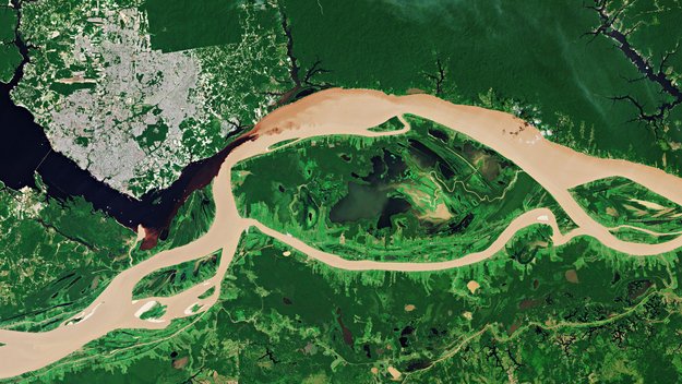
Earth observation image of the week: Copernicus Sentinel-2 takes us over the junction where the Rio Negro and the Solimões river meet to form the Amazon River
Earth from Space
27.9.2019 10:05 ESA Observing the Earth
This week's edition features the confluence of the Negro and Solimões rivers in the Amazon Basin
OpenData Bratislava
27.9.2019 8:09 GISportal.cz
Město Bratislava se rozhodlo publikovat svá data pod otevřenou licencí (CC Atribution 4.0). Data jsou k dispozici ve dvanácti kategoriích (viz níže) většinou jako csv soubory, občas jako PDF, či txt. Data jsou ke stažení na opendata.bratislava.sk. Doprava – 22 datasetov Ekonomika a práca – 26 datasetov Infraštruktúra, výstavba a bývanie – 22 datasetov Kultúra, voľný […]
The post OpenData Bratislava appeared first on GISportal.cz.
Blue Marble will present the latest features of Global Mapper v21 in a free live webinar on October 3
27.9.2019 0:36 GISCafe.com Webcasts-Webinars Above is a screenshot of the new tool in Global Mapper v21 for finding peaks and depressions in a terrain …Esri ArcGIS QuickCapture Supports Eos Arrow GNSS on iOS, Android, and Windows
26.9.2019 19:08 GISCafe.com Webcasts-Webinars Arrow GNSS receivers provide ArcGIS QuickCapture users with submeter/centimeter locations at high rate, enabling high-accuracy data collection from …New Context and Idaho National Laboratory to Develop Operational Cybersecurity Technology
26.9.2019 16:27 GISCafe.com Webcasts-Webinars SAN FRANCISCO — (BUSINESS WIRE) — September 26, 2019 —New Context, a leading innovator in cybersecurity research for highly …
Esri Publishes Mark Monmonier Book on Exploring Maps as Networks
26.9.2019 16:27 GISCafe.com Webcasts-Webinars New History of Cartography Examines How Modern Methods EvolvedREDLANDS, Calif. — (BUSINESS WIRE) — September 26, 2019 —
Esri, the …
Telstra inspects towers with AI and 3D models
26.9.2019 15:12 Bentley SystemsPress Coverage
Infrastructure Intelligence, Australia/New Zealand
Read the articleSiemens and Bentley Systems announce Capital Asset Lifecycle Management (CALM) solution for Teamcenter software
26.9.2019 15:07 Bentley SystemsPress Coverage
Automation.com, India
Read the articleSurveying & BIM: Working as one
26.9.2019 15:03 Bentley SystemsPress Coverage
Construction Europe, UK
Read the articleTransitioning from Engineering to Marketing
26.9.2019 14:59 Bentley SystemsPress Coverage
The Engineering Career Coach Podcast, USA
Read the articleBeijing's starfish airport
26.9.2019 14:40 ESA Observing the Earth
China’s Daxing International Airport, boasting the world’s largest single-building terminal, is now open for business
Beijing's starfish airport
26.9.2019 14:40 ESA Observing the Earth
China’s Daxing International Airport, boasting the world’s largest single-building terminal, is now open for business
Keynote Speakers for URISA's 2019 Caribbean GIS Conference Announced
26.9.2019 12:15 GISCafe.com Webcasts-Webinars Des Plaines, IL (September 25, 2019) -- URISA is pleased to announce the keynote speakers for the 9th URISA Caribbean GIS Conference, …Kosmonaut Luca Parmitano přebírá hlavní roli pro Evropu
26.9.2019 11:04 Český Kosmický PortálKosmonaut ESA Luca Parmitano je připravený stát se třetím evropským a prvním italským velitelem Mezinárodní kosmické stanice. Stane se tak po oficiální ceremonii ve středu 2. října 2019.
Digitální realita přináší skutečnou efektivitu (workshop)
26.9.2019 8:12 GISportal.cz
HEXAGON GEOSPATIAL ve spolupráci se společností GEFOS vás srdečně zve na odborný workshop zaměřený na téma 3D mračna bodů. Termín: čtvrtek 24. října 2019 Místo konání: Konferenční centrum Green Point Dvouletky 529/42, Praha 10 – Strašnice, www.kc-greenpoint.cz/ Účast na workshopu je zdarma. Registrace je nutná! Na workshopu vám organizátoři představí pořízení 3D barevných mračen bodů, jejich zpracování […]
The post Digitální realita přináší skutečnou efektivitu (workshop) appeared first on GISportal.cz.
Airbus to develop technology for ultra-high-resolution satellites for UK MOD
25.9.2019 23:47 GISCafe.com Webcasts-Webinars London, 11 September 2019 – Airbus has won a design study from the UK’s Defence Science and Technology Laboratory (Dstl) to …
Introducing the Geode GNS2 Sub-meter GPS Receiver
25.9.2019 18:56 GISCafe.com Webcasts-Webinars MFi Certified for iPhone and iPad CompatibilityLogan, UT – Juniper Systems is excited to announce the release of the Geode GNS2 …