


![]()

zprávy
zdroje zpráv:Stipendijní možnosti do německy mluvicích zemí, akad. rok 2020/2021
16.9.2019 8:15 Blogující geomatici - FAV ZČUdovolujeme si Vás informovat o stipendijních nabídkách na základě
mezinárodních smluv do tří německy mluvicích zemí. Přihlášky se mohou
podávat v německém nebo anglickém jazyce (s výjimkou letních jazykových
kurzů NJ, viz DAAD).
1.Německo - DAAD
<https://www.dzs.cz/cz/akademicka-informacni-agentura/stipendia/?type_id=5&country_id=29>
Německá akademická výměnná služba (DAAD) nabízí řadu stipendií pro různé
skupiny (pro studenty od 2. ročníku, studenty MSP, doktorandy, vědce až
po VŠ učitele). Ve výše uvedené tabulce naleznete odkaz na stránky DAAD,
kde je podrobný popis každé stipendijní nabídky. Rovněž tam naleznete
popis, jak podat přihlášku.
*Online-portál DAAD je již otevřený* pro přijímání Vašich žádostí.
U většiny studijních a výzkumných pobytů (delších a kratších) se žádosti
podávají do *15. 11. 2019*.
Žádosti o stipendia na letní kurzy němčiny se podávají do *1. 12*.
Tištěnou verzi žádosti posílejte, prosím, do sídla Akademické informační
agentury (AIA), Dům zahraniční spolupráce, Na Poříčí 1035/4, 110 00 Praha 1.
Výjimka:
Studenti MSP v oborech *architektura, umění, film, scénické umění a
hudba*, posílají svoje žádosti elektronicky přes portál DAAD a paralelně
v tištěné verzi včetně ukázek prací přímo do centrály DAAD v Bonnu.
Upozorňujeme na *dřívější deadline* pro tato stipendia: architektura
30.9.2019, hudba 15. 10. 2019, scénické umění 31. 10. 2019 a výtvarné
umění, design, vizuální komunikace a film 30. 11.2019.
2.Německo – Česko-bavorská vysokoškolská agentura
<https://www.dzs.cz/cz/akademicka-informacni-agentura/stipendia/?type_id=5&country_id=28>
Česko-bavorská vysokoškolská agentura (BTHA) nabízí roční studijní
pobyty pro studenty DSP a MSP. Žádosti o stipendium se přijímají
nejpozději do *1. 12. 2019.*
Stipendijní podmínky, informace o potřebných dokladech a doručující
adresy naleznete ve výše uvedené tabulce.
3.Švýcarsko – stipendia vlády Švýcarské konfederace
<https://www.dzs.cz/cz/akademicka-informacni-agentura/stipendia/?type_id=5&country_id=44>
a.Vláda Švýcarské konfederace nabízí České republice pro akademický rok
2020/2021 *dvě stipendijní místa pro studenty DSP a postdoktorandy/vědce*.
b.Vláda Švýcarské konfederace nabízí stipendia pro *studenty*
*konzervatoří a VŠ uměleckých* *směrů. *V této kategorii nemá Česká
republika daný počet stipendijních míst.
Zájemci, kteří splňují formální podmínky pro přidělení stipendia, obdrží
na základě své žádosti od Akademické informační agentury (AIA)
elektronickou cestou podklady pro podání žádosti v anglickém jazyce.
4.Rakousko – AKTION
<https://www.dzs.cz/cz/aktion-ceska-republika-rakousko/prehled-stipendii/>
a.Studenti MSP, DSP a akademičtí pracovníci se mohou ucházet o
semestrální stipendium (1-5 m) do 31. 10. 2019.
b.VŠ učitelé se mohou ucházet o 1-měsíční stipendijní výzkumný pobyt do
30. 11. 2019.
Vyhlášení výběrového řízení FreeMovers LS 2019/2020
16.9.2019 8:14 Blogující geomatici - FAV ZČU Bylo vyhlášeno předkolo výběrového řízení INTER-20, neboli "FreeMovers" na letní semestr 2019/2020.Přihlášky do tohoto výběrového řízení doručte katedrálnímu koordinátorovi do 14. 10. 2019.
20190916-GaKO-9-2019
16.9.2019 8:13 ČÚZK - předpisy a opatření Český úřad zeměměřický a katastrální zveřejnil novou aktualitu: Aktuální číslo Geodetického a kartografického obzoru (9/2019) je k dispozici ke stažení.
Nové číslo GaKO
16.9.2019 8:10
ÚGKK SR
Nové číslo časopisu Geodetického a Kartografického Obzoru 9/2019
Pokyny pro zpracování závěrečných prací
16.9.2019 0:00 Geografický ústav MUAktualizované pokyny pro zpracování bakalářských a diplomových prací z geografie a kartografie jsou ke stažení na adrese https://is.muni.cz/auth/el/sci/jaro2019/Z6004/Pokyny_BPDP_v2019.pdf.
Od předchozí verze se tyto nové pokyny liší v následujících bodech:
- nové logo Masarykovy univerzity na deskách a titulním listu,
- možnost tisku vlastního textu práce oboustranně,
- odevzdání dvou tištěných exemplářů.
Projekty řešené na katedře [Katedra aplikované geoinformatiky a kartografie, byTopic]
15.9.2019 17:55 Katedra aplikované geoinformatiky a kartografie Přf UK Jednou z důležitých činností katedry aplikované geoinformatiky a kartografie je její účast v grantových soutěžích. V současné době jsou naši vědečtí pracovníci zapojeni do 18-ti projektů. Podívejte se na jejich seznam.Projekty řešené na katedře [Katedra aplikované geoinformatiky a kartografie, byTopic]
15.9.2019 17:55 Katedra aplikované geoinformatiky a kartografie Přf UK Jednou z důležitých činností katedry aplikované geoinformatiky a kartografie je její účast v grantových soutěžích. V současné době jsou naši vědečtí pracovníci zapojeni do 19-ti projektů. Podívejte se na jejich seznam."GICHD: Using GIS for Clearing Landmines and Restoring Land to Use" by Susan Smith
15.9.2019 11:26 GISCafe.com Webcasts-WebinarsOrbit GT launches Marketplace for 3D Mapping Content at INTERGEO, Stuttgart
15.9.2019 10:45 GISCafe.com Webcasts-Webinars Lokeren, Belgium, September 12th, 2019 -- Orbit GT launches the Marketplace for all and any 3D Mapping Content at INTERGEO, …CHC Navigation Introduces the i90 IMU-RTK GNSS Series
15.9.2019 10:23 GISCafe.com Webcasts-Webinars Significantly increase GNSS RTK positioning availability and survey productivity.Shanghai, China – September 13th, 2019 - CHC Navigation …
GaKO 9/2019
15.9.2019 9:29 GaKO GaKO 9/2019 NOSEK, J.: Analýza geometrie sítě transformované globálním klíčem verze 1710 DOMBIOVÁ, K.–MORAVČÍKOVÁ, K.: Digitálna kartografia priestorových objektov ZBGIS®GaKO 9/2019
15.9.2019 9:21 GaKO GaKO 9/2019 NOSEK, J.: Analýza geometrie sítě transformované globálním klíčem verze 1710 DOMBIOVÁ, K.–MORAVČÍKOVÁ, K.: Digitálna kartografia priestorových objektov ZBGIS®GaKO 9/2019
15.9.2019 9:21 GaKO GaKO 9/2019 NOSEK, J.: Analýza geometrie sítě transformované globálním klíčem verze 1710 DOMBIOVÁ, K.–MORAVČÍKOVÁ, K.: Digitálna kartografia priestorových objektov ZBGIS®Program letošní konference o směrnici INSPIRE
13.9.2019 22:55 GeoBusiness Letošní ročník konference, věnované směrnici INSPIRE, se koná na Slovensku. Registrace je možná pouze do 23. září. Program konference Inspirujme se… 2019 UTOROK 8. ... PřečístProgram letošní konference o směrnici INSPIRE
13.9.2019 22:55 GeoBusiness Letošní ročník konference, věnované směrnici INSPIRE, se koná na Slovensku. Registrace je možná pouze do 23. září. Program konference Inspirujme se… 2019 UTOROK 8. 10. 2019 09:00–12:00 Registrácia 10:00–10:15 Otvorenie konferencie Úvodné slovo SR Eva Rusnáková, Ministerstvo životného prostredia SR Úvodné slovo ČR Miroslav Havránek, CENIA, česká informační agentura životního prostředí Anna Pasková, Ministerstvo životního […]Allen Wainger, PE Joins AXIS GeoSpatial LLC as Director of Program Management
13.9.2019 16:45 GISCafe.com Webcasts-Webinars Easton, Maryland - AXIS GeoSpatial LLC is pleased to announce the addition of Allen Wainger, PE to their Project Management team. Wainger …Oracle OpenWorld 2019, Breakthrough Starts Here
13.9.2019 16:45 GISCafe.com Webcasts-Webinars Oracle Cloud: The First and Only Autonomous CloudSAN FRANCISCO, Sept. 13, 2019 — (PRNewswire) — Oracle OpenWorld -- Oracle …
ɸ-week highlights
13.9.2019 16:20 ESA Observing the Earth
As ESA’s second ɸ-week has drawn to a close, let’s take a look at some of the highlights
ɸ-week highlights
13.9.2019 16:20 ESA Observing the EarthAs ESA’s second ɸ-week has drawn to a close, let’s take a look at some of the highlights
referent KN – právník do právního oddělení III.
13.9.2019 15:49 ČÚZK - volná místa Katastrální úřad pro hlavní město Prahu - Katastrální pracoviště Praha vypisuje výběrové řízení na místo referent KN – právník do právního oddělení III.referent KN – právník do právního oddělení III.
13.9.2019 15:49 ČÚZK - předpisy a opatření Katastrální úřad pro hlavní město Prahu - Katastrální pracoviště Prahavypisuje výběrové řízení na místo
referent KN – právník do právního oddělení III.
referent KN – návrh zápisu, kontrola a zplatnění do PO VIII.
13.9.2019 15:48 ČÚZK - volná místa Katastrální úřad pro hlavní město Prahu vypisuje výběrové řízení na místo referent KN – návrh zápisu, kontrola a zplatnění do PO VIII.referent KN – návrh zápisu, kontrola a zplatnění do PO VIII.
13.9.2019 15:48 ČÚZK - předpisy a opatření Katastrální úřad pro hlavní město Prahuvypisuje výběrové řízení na místo
referent KN – návrh zápisu, kontrola a zplatnění do PO VIII.
referent KN – návrh zápisu, kontrola a zplatnění do PO VIII.
13.9.2019 15:48 ČÚZK - volná místa Katastrální úřad pro hlavní město Prahu - Katastrální pracoviště Praha vypisuje výběrové řízení na místo referent KN – návrh zápisu, kontrola a zplatnění do PO VIII.referent KN – návrh zápisu, kontrola a zplatnění do PO VIII.
13.9.2019 15:48 ČÚZK /Urady/Katastralni-urady/Katastralni-urady/Katastralni-urad-pro-hlavni-mesto-Prahu/Uredni-deska/Oznameni-a-jina-uredni-sdeleni/Volna-mista/referent-KN-–-navrh-zapisu,-kontrola-a-zplatneni-dreferent KN – návrh zápisu, kontrola a zplatnění do PO VIII.
13.9.2019 15:48 ČÚZK - předpisy a opatření Katastrální úřad pro hlavní město Prahu - Katastrální pracoviště Prahavypisuje výběrové řízení na místo
referent KN – návrh zápisu, kontrola a zplatnění do PO VIII.
odborný referent – poskytování informací KN
13.9.2019 15:42 ČÚZK - předpisy a opatření Katastrální úřad pro hlavní město Prahu - Katastrální pracoviště Prahavypisuje výběrové řízení na místo
odborný referent – poskytování informací KN
odborný referent – poskytování informací KN
13.9.2019 15:42 ČÚZK /Urady/Katastralni-urady/Katastralni-urady/Katastralni-urad-pro-hlavni-mesto-Prahu/Uredni-deska/Oznameni-a-jina-uredni-sdeleni/Volna-mista/referent-KN-–-vedeni-DKM,-vedeni-katastralni-mapyodborný referent – poskytování informací KN
13.9.2019 15:42 ČÚZK - volná místa Katastrální úřad pro hlavní město Prahu - Katastrální pracoviště Praha vypisuje výběrové řízení na místo odborný referent – poskytování informací KNČeský žákovský experiment běžel na ISS!
13.9.2019 14:39 Český Kosmický PortálŠest žáků 6. třídy z 1. ScioŠkoly na Praze 11 se na podzim 2018 rozhodlo, že se naučí programovat v jazyce Python a vymyslí experiment, který následně pošlou v rámci evropské soutěže Astro Pi mise SpaceLab na Mezinárodní vesmírnou stanici ISS. A to se jim podařilo! Stali se tak jedněmi z mála, jejichž kód běžel ve vesmíru.
VŘ TO Olomouc
13.9.2019 13:18 ČÚZK - předpisy a opatření Katastrální úřad pro Olomoucký kraj zveřejnil novou aktualitu: OZNÁMENÍ O VYHLÁŠENÍ VÝBĚROVÉHO ŘÍZENÍ na služební místo:odborný referent/vrchní referent – obnova katastrálního operátu, na Katastrálním úřadu pro Olomoucký kraj, Technický odbor - pracoviště Opava.
VŘ TO Olomouc
13.9.2019 13:18 ČÚZK /Urady/Katastralni-urady/Katastralni-urady/Katastralni-urad-pro-Olomoucky-kraj/O-uradu/Aktuality/VR-TO-Olomoucodborný referent/vrchní referent – obnova katastrálního operátu
13.9.2019 12:48 ČÚZK /Urady/Katastralni-urady/Katastralni-urady/Katastralni-urad-pro-Olomoucky-kraj/Uredni-deska/Oznameni-a-jina-uredni-sdeleni/Volna-mista/odborny-referent-vrchni-referent-–-obnova-katastraodborný referent/vrchní referent – obnova katastrálního operátu
13.9.2019 12:48 ČÚZK - předpisy a opatření Katastrální úřad pro Olomoucký kraj - technický odborvypisuje výběrové řízení na místo
odborný referent/vrchní referent – obnova katastrálního operátu
odborný referent/vrchní referent – obnova katastrálního operátu
13.9.2019 12:48 ČÚZK - volná místa Katastrální úřad pro Olomoucký kraj - technický odbor vypisuje výběrové řízení na místo odborný referent/vrchní referent – obnova katastrálního operátuRelive ɸ-week
13.9.2019 12:15 ESA Observing the Earth
Replay the livestream of ESA’s ɸ-week, which explored how open science and innovation can benefit from the latest digital technologies to shape the future of Earth observation
AUTO Suzuki SX4 1.6 GLX 4WD
13.9.2019 11:34 ČÚZK - předpisy a opatřeníZeměměřický úřad nabízí nepotřebný majetek k odkupu. Jedná se o
AUTO Suzuki SX4 1.6 GLX 4WD
AUTO Suzuki SX4 1.6 GLX 4WD
13.9.2019 11:34 ČÚZK /Urady/Zememericky-urad/Nabidka-majetku/AUTO-Suzuki-SX4-1-6-GLX-4WDAUTO Suzuki SX4 1.6 GLX 4WD
13.9.2019 11:34 Zeměměřický úřadZeměměřický úřad nabízí nepotřebný majetek k odkupu. Jedná se o
AUTO Suzuki SX4 1.6 GLX 4WD
GSA, EIB sign agreement on investment in space
13.9.2019 11:33 European GNSS Agency
The European GNSS Agency (GSA) and the European Investment Bank (EIB) have signed an agreement to cooperate on supporting investment in the European space-based service economy. The agreement was signed as part of celebrations at GSA headquarters in Prague on September 10 to mark the Agency’s 15th anniversary.
With the new agreement, the GSA and EIB are bringing together their expertise and experience to explore new investment support for the European space-based economy. The common objective is to create high-skilled jobs in the EU and improve the day-to-day lives of Europeans by supporting innovative companies and accelerating the development of new applications that use European global navigation satellite systems and earth observation data.
Read this: GSA celebrates 15 years
European Commissioner for the Internal Market, Industry, Entrepreneurship and SMEs Elżbieta Bieńkowska has noted several times the critical importance of adequate funding for the future of the European space industry. "Access to finance remains a significant hurdle to unleashing the potential of European space entrepreneurship within and outside Europe,” the Commissioner said. This new agreement between the GSA and the EIB will help to overcome this hurdle.
Keeping Europe in the game
“Our expertise in market intelligence for satellite navigation and in supporting new business opportunities – thanks to EGNOS and Galileo – is the basis of our agreement with the EIB,” said Carlo des Dorides, GSA Executive Director. “We are confident that our cooperation will bring the extra added value required by entrepreneurs to transform their application businesses into globally successful companies.”
“We need to make sure that Europe stays in the game. That is why we are particularly enthusiastic about this agreement with GSA. It is an important step to develop further support for European space entrepreneurs and businesses to eventually give them and the EU a competitive edge in this new space race,” said EIB Vice-President Ambroise Fayolle, responsible for innovation.
A changing space sector
The global space economy has been evolving rapidly in recent years, with average annual growth of 6.7% over the past 10 years, which is almost twice the 3.5% average yearly growth of the global economy. The main driver of this growth has been the “New Space” phenomenon: a number of technological and business model innovations that have introduced new products and services and reduced the cost of accessing and using space.
And this: GSA celebrates 1 billion Galileo smartphone users
The transformation of the space economy has seen new space companies investing over EUR 14.8 billion since 2000, with a fast accelerating trend: total investment in space companies grew by a factor of 3.5 in 2012–2017 compared with the previous six-year period.
Historically, Europe has always been at the forefront of publicly-funded space exploration, investing massively in space infrastructures such as the Copernicus and Galileo satellite programmes. Europe still boasts academic and scientific excellence but risks missing the next wave of space innovation unless it seizes the opportunity to stimulate more private investment in the new space sector. This is something that the new agreement between the GSA and the EIB aims to address.
Media note: This feature can be republished without charge provided the European GNSS Agency (GSA) is acknowledged as the source at the top or the bottom of the story. You must request permission before you use any of the photographs on the site. If you republish, we would be grateful if you could link back to the GSA website (http://www.gsa.europa.eu).
Winning bootcamp ideas at Φ-week
13.9.2019 11:15 ESA Observing the Earth
On the sidelines of ESA’s Φ-week, a five-day app-development bootcamp took place where young developers came together to solve big industry challenges using Earth observation data. The teams developed app prototypes, which were tested by a set of users. Those with the best commercial potential were awarded with prizes.
Pozemkové úpravy – nástroj pro zmírnění negativních dopadů klimatických změn
13.9.2019 10:26 ZeměměřičSeminář je určen zejména pro pracovníky pozemkových úřadů SPÚ, projektanty pozemkových úprav a společných zařízení, geodety a studenty souvisejících oborů. Vítána je účast další odborné i laické veřejnosti se zájmem o dané téma. Cílem semináře je seznámit účastníky s aktuálními principy, způsoby a přístupy k řešení vodohospodářských opatření v rámci komplexních pozemkových úprav, které zmírňují negativní dopady klimatických změn v krajině. V případě zájmu […]
The post Pozemkové úpravy – nástroj pro zmírnění negativních dopadů klimatických změn appeared first on Zeměměřič.
Earth from Space
13.9.2019 10:05 ESA Observing the Earth
In this week's edition, explore Baja California in northern Mexico with Copernicus Sentinel-1
Baja California
13.9.2019 10:05 ESA Observing the Earth
Earth observation image of the week: Copernicus Sentinel-1 takes us over Baja California, in northern Mexico
Předseda APG vystoupí na Technologickém fóru s referátem o garantovaných datech
13.9.2019 9:40 Asociace podnikatelů v geomatice Technologické fórum zahajuje 17. září 2019 již třicátý ročník veletrhu FOR ARCH na výstavišti v pražských Letňanech. Na diskusním fóru vystoupí rovněž Martin Hrdlička, předseda Asociace podnikatelů v geomatice, s referátem nazvaným „Garantovaná data – základ digitalizace“. Jednodenní neformální setkání zástupců investorů, developerů, projektantů, státní správy, samosprávy, akademické obce a vystavovatelů se uskuteční 17. září 2019 na výstavišti v Praze-Letňanech. V přednáškové […]DTM, garantovaná data, digitalizace stavebního povolení – to je letošní Technologické fórum na FOR ARCHu
13.9.2019 9:17 GeoBusiness Technologické fórum letos slavnostně zahájí třicátý ročník mezinárodního stavebního veletrhu FOR ARCH. Jednodenní neformální setkání zástupců investorů, developerů, projektantů, státní správy, samosprávy, akademické obce ... PřečístDTM, garantovaná data, digitalizace stavebního povolení – to je letošní Technologické fórum na FOR ARCHu
13.9.2019 9:17 GeoBusiness Technologické fórum letos slavnostně zahájí třicátý ročník mezinárodního stavebního veletrhu FOR ARCH. Jednodenní neformální setkání zástupců investorů, developerů, projektantů, státní správy, samosprávy, akademické obce a vystavovatelů se uskuteční 17. září 2019 na výstavišti v Praze-Letňanech. Organizátoři uveřejnili finální program konference a v přednáškové sekci si budete moci poslechnout referáty Koncepce digitalizace stavebního řízení a územního […]V Kutné Hoře proběhne Členská schůze ČKS
13.9.2019 9:06 Česká kartografická společnost V rámci 23. kartografické konference se ve čtvrtek 19. 9. 2019 od 18 hodin uskuteční Členská schůze ČKS. Program jednání je následující: (1) Zahájení, (2) Volba mandátové a návrhové komise, (3) Zpráva mandátové komise, (4) Zpráva o činnosti ČKS za období listopad 2018 až srpen 2019, (5) Zpráva Kontrolní komise ČKS za období listopad 2018 až […]Úspech na mezinárodní kartografické výstavě
13.9.2019 9:03 Česká kartografická společnost Již tradičně je součástí Mezinárodní kartografické konference i výstava produktů členských zemí Mezinárodní kartografické asociace, a to pod názvem Mezinárodní kartografická výstava (International Cartographic Exhibition). Výstava je tradičně soutěžní, přičemž porota je složena z vybraných odborníků a účastníci konference volí ocenění v kategoriích „public vote“. Letos jsme získali rovnou dvě ocenění, a to pro Hmatové mapy TouchIt3D, které […]Vrchní/odborný referent v oddělení obnovy katastrálního operátu II. v technickém odboru na Katastrál
13.9.2019 9:00 ČÚZK - volná místa Katastrální úřad pro Ústecký kraj - technický odbor vypisuje výběrové řízení na místo Vrchní/odborný referent v oddělení obnovy katastrálního operátu II. v technickém odboru na KatastrálVrchní/odborný referent v oddělení obnovy katastrálního operátu II. v technickém odboru na Katastrál
13.9.2019 9:00 ČÚZK - předpisy a opatření Katastrální úřad pro Ústecký kraj - technický odborvypisuje výběrové řízení na místo
Vrchní/odborný referent v oddělení obnovy katastrálního operátu II. v technickém odboru na Katastrálním úřadu pro Ústecký kraj
Vrchní/odborný referent v oddělení obnovy katastrálního operátu II. v technickém odboru na Katastrál
13.9.2019 9:00 ČÚZK /Urady/Katastralni-urady/Katastralni-urady/Katastralni-urad-pro-Ustecky-kraj/Uredni-deska/Oznameni-a-jina-uredni-sdeleni/Volna-mista/Vrchni-odborny-referent-v-oddeleni-obnovy-katastraŠestý ročník největší české konference o 3D tisku
13.9.2019 8:58 GeoBusiness Již šestý ročník Fóra aditivní výroby představí nejvyspělejší metody profesionálního 3D tisku, který se stává dostupnějším i pro menší firmy a jednotlivce. Organizátoři připravili širokou přehlídku technologií aditivní výroby kovových, plastových i kompozitních dílů s velkým zaměřením na praxi. Ačkoliv je konference určena především pro odborníky z průmyslu, mohou se mezi čtenáři GeoBusinessu najít geoinformatici se […]Šestý ročník největší české konference o 3D tisku
13.9.2019 8:58 GeoBusiness Již šestý ročník Fóra aditivní výroby představí nejvyspělejší metody profesionálního 3D tisku, který se stává dostupnějším i pro menší firmy a jednotlivce. Organizátoři připravili ... PřečístAPGEO - PŘEDSEDA APG VYSTOUPÍ NA TECHNOLOGICKÉM FÓRU S REFERÁTEM O GARANTOVANÝCH DATECH
13.9.2019 2:00 Asociace podnikatelů v geomatice Technologické fórum zahajuje 17. září 2019 již třicátý ročník veletrhu FOR ARCH na výstavišti v pražských Letňanech...DJI and Delair Partner to Enhance Visual Data Collection, Management & Analysis for Enterprises
13.9.2019 0:16 GISCafe.com Webcasts-Webinars Collaboration will focus on the compatibility of DJI systems with the delair.ai cloud platformTOULOUSE, France — (BUSINESS WIRE) — …
2019 CoreLogic Wildfire Risk Report Highlights U.S. Wildfire Vulnerability, Finding Nearly 776,000 Homes at Extreme Risk of Wildfire Damage This Year
13.9.2019 0:16 GISCafe.com Webcasts-Webinars — The total estimated reconstruction cost value for these extreme-risk homes is more than $221 billion, with California metropolitan areas …Teledyne Optech announces the CL-360, a compact, long-range, survey-grade lidar sensor for UAV and mobile applications
13.9.2019 0:16 GISCafe.com Webcasts-Webinars VAUGHAN, Ontario, Sept. 12, 2019 (GLOBE NEWSWIRE) -- Teledyne Optech, a Teledyne Technologies [NYSE:TDY] company and global leader in …Michael Baker International Marks 10 Years of Mobile LiDAR
13.9.2019 0:16 GISCafe.com Webcasts-Webinars Firm's early adoption of the emerging technology evolves to premier industry leadership positionPITTSBURGH, Sept. 12, 2019 — (PRNewswire) …
CoreLogic Reports an 11.4% Year-over-Year Decrease in Mortgage Fraud Risk in the Second Quarter of 2019
12.9.2019 15:02 GISCafe.com Webcasts-Webinars Risk index decreases for the first time since Q3 2016 as lower interest rates brought an influx of low-risk refinancesiBuyers represent a new …
EKA Solutions Licenses Trimble's Mapping Web APIs to Deliver Enhanced ETA and Visibility Solutions
12.9.2019 15:02 GISCafe.com Webcasts-Webinars Trimble MAPS Development Platform Web APIs Enables EKA to Provide Real-Time Trip Management and Precise ETAs as Part of its Cloud-Based TMS …Airbus to develop technology for ultra-high-resolution satellites for UK MOD
12.9.2019 13:39 GISCafe.com Webcasts-Webinars London, 11 September 2019 – Airbus has won a design study from the UK’s Defence Science and Technology Laboratory (Dstl) to …100+ Presenters and Panelists on Roster for Commercial UAV Expo Americas October 28-30, 2019 in Las Vegas
12.9.2019 13:32 GISCafe.com Webcasts-Webinars Industry leaders will provide insights into key issues related to commercial dronesLas Vegas, NV – September 12, 2019 – More than 100 …
Introducing the Geode GNS2 Sub-meter GPS Receiver, now compatible with iPhone and iPad
12.9.2019 12:30 GISCafe.com Webcasts-Webinars September 12, 2019 -- Juniper Systems is excited to introduce the next evolution of the Geode™ Sub-meter GPS Receiver, the GNS2. This new …Percepto at Smart Mining 2.0 to Demonstrate How Autonomous Drones are Transforming Mining Operations Around the World
12.9.2019 11:27 GISCafe.com Webcasts-Webinars Learn How a Drone-in-a-Box Can Improve Monitoring, Inspection, Surveying, Compliance, Safety and SecuritySeptember 12, 2019 -- Percepto, …
First Earth observation satellite with AI ready for launch
12.9.2019 11:12 ESA Observing the Earth
A few months from now will see the launch of the first European satellite to demonstrate how onboard artificial intelligence can improve the efficiency of sending Earth observation data back to Earth. Dubbed ɸ-Sat, or PhiSat, this revolutionary artificial intelligence technology will fly on one of the two CubeSats that make up the FSSCat mission – a Copernicus Masters winning idea.
Aktualizace údajů
12.9.2019 11:12 Ústecký kraj V Geoportálu ÚAP Ústeckého kraje byla provedena aktualizace údajů pro poskytovatele České Radiokomunikace a.s. – jev 81, 82, ČEPS, a.s. – jev 72, 73 a MERO ČR, a.s. – jev 77.Awarding pioneering contribution in the field of point cloud processing
12.9.2019 11:03 GISCafe.com Webcasts-Webinars HEERBRUGG, Switzerland, STUTTGART, Germany, 11 September 2019) – Leica Geosystems, part of Hexagon, is pleased to announce the Carl …Monitorování znečištění atmosféry z požárů
12.9.2019 10:59 Český Kosmický PortálV posledních týdnech plní novinové titulky lesní požáry, které devastují amazonské deštné pralesy. Tyto požáry přitom představují tragédii nejen coby ztráta lesů a biodiverzity, ale také zanechávají výraznou stopu v atmosféře. Mají tak vliv na kvalitu ovzduší a potenciálně také na změnu klimatu.
Vyhlášení výběrového řízení
12.9.2019 10:37 ČÚZK - předpisy a opatření Katastrální úřad pro Plzeňský kraj - Katastrální pracoviště Domažlice zveřejnil novou aktualitu: Ředitel Katastrálního úřadu pro Plzeňský kraj vyhlašuje výběrové řízení na služební místo odborný rada – vedoucí oddělení právních vztahů k nemovitostem – VOPV04 . Místem výkonu služby jsou Domažlice. Přihlášky zasílejte do 23.9.2019. Předpokládaným dnem nástupu je 1. 11. 2019Vyhlášení výběrového řízení
12.9.2019 10:37 ČÚZK - předpisy a opatření Katastrální úřad pro Plzeňský kraj - Katastrální pracoviště Domažlice zveřejnil novou aktualitu: Ředitel Katastrálního úřadu pro Plzeňský kraj vyhlašuje výběrové řízení na služební místo odborný rada – vedoucí oddělení právních vztahů k nemovitostem – VOPV04 . Místem výkonu služby jsou Domažlice. Přihlášky zasílejte do 23.9.2019. Předpokládaným dnem nástupu do služby je 1.11.2019Vyhlášení výběrového řízení
12.9.2019 10:37 ČÚZK /Urady/Katastralni-urady/Katastralni-urady/Katastralni-urad-pro-Plzensky-kraj/Katastralni-pracoviste/KP-Domazlice/O-uradu/Aktuality/Vyhlaseni-vyberoveho-rizeniV příštím vydání Esri Map Book můžete být i vy
12.9.2019 9:30 ARCDATA
Vydavatelství Esri Press každým rokem vydává sbírku Map Book, kde naleznete inspirativní mapy z celého světa napříč obory.
Ani v letošním vydání nechybí čeští uživatelé. K vidění je ukázka aplikace ze společnosti ČEZ Distribuce, kterou připravila společnost HSI, spol. s r. o., člen skupiny Unicorn, a výstupy projektu dokumentujícího zříceninu hradu Rýzmburk z Fakulty životního prostředí Univerzity Jana Evangelisty Purkyně v Ústí nad Labem.
Chcete být součástí 35. ročníku sborníku Esri Map Book?
Sdílejte své projekty nejpozději do konce října prostřednictvím webového portálu. Na stránkách Esri Map Book, volume 35, pak naleznete veškeré informace týkající se formuláře.
Odborný rada – vedoucí oddělení právních vztahů k nemovitostem – VOPV04, Katastrální pracoviště Do
12.9.2019 9:20 ČÚZK /Urady/Katastralni-urady/Katastralni-urady/Katastralni-urad-pro-Plzensky-kraj/Uredni-deska/Oznameni-a-jina-uredni-sdeleni/Volna-mista/Odborny-rada-–-vedouci-oddeleni-pravnich-vztahu-kOdborný rada – vedoucí oddělení právních vztahů k nemovitostem – VOPV04, Katastrální pracoviště Do
12.9.2019 9:20 ČÚZK - předpisy a opatření Katastrální úřad pro Plzeňský kraj - Katastrální pracoviště Domažlicevypisuje výběrové řízení na místo
Odborný rada – vedoucí oddělení právních vztahů k nemovitostem – VOPV04, Katastrální pracoviště Domažlice
Odborný rada – vedoucí oddělení právních vztahů k nemovitostem – VOPV04, Katastrální úřad pro Plze
12.9.2019 9:20 ČÚZK - volná místa Katastrální úřad pro Plzeňský kraj - Katastrální pracoviště Domažlice vypisuje výběrové řízení na místo Odborný rada – vedoucí oddělení právních vztahů k nemovitostem – VOPV04, Katastrální úřad pro PlzeOdborný rada – vedoucí oddělení právních vztahů k nemovitostem – VOPV04, Katastrální pracoviště Do
12.9.2019 9:20 ČÚZK - volná místa Katastrální úřad pro Plzeňský kraj - Katastrální pracoviště Domažlice vypisuje výběrové řízení na místo Odborný rada – vedoucí oddělení právních vztahů k nemovitostem – VOPV04, Katastrální pracoviště DoOdborný rada – vedoucí oddělení právních vztahů k nemovitostem – VOPV04, Katastrální úřad pro Plze
12.9.2019 9:20 ČÚZK - předpisy a opatření Katastrální úřad pro Plzeňský kraj - Katastrální pracoviště Domažlicevypisuje výběrové řízení na místo
Odborný rada – vedoucí oddělení právních vztahů k nemovitostem – VOPV04, Katastrální úřad pro Plzeňský kraj, Katastrální pracoviště Domažlice
Odborný rada – vedoucí oddělení právních vztahů k nemovitostem – VOPV04, Katastrální úřad pro Plze
12.9.2019 9:20 ČÚZK /Urady/Katastralni-urady/Katastralni-urady/Katastralni-urad-pro-Plzensky-kraj/Uredni-deska/Oznameni-a-jina-uredni-sdeleni/Volna-mista/Odborny-rada-–-vedouci-oddeleni-pravnich-vztahu-kINSPIRE - Nadmořská výška-GRID (EL GRID)
12.9.2019 2:00 Cenia - Katalog metadat ČR - INSPIRE INSPIRE prohlížecí služba WMS pro data Nadmořská výška - GRID (EL GRID) poskytuje možnost prohlížet obraz dat INSPIRE tématu Nadmořská výška - GRID. Data jsou harmonizována dle prováděcích pravidel INSPIRE.Výškopis DMP 1G
12.9.2019 2:00 Cenia - Katalog metadat ČR - INSPIRE Prohlížecí služba WMS - DMP 1G je poskytována jako veřejná služba pro využití datové sady Digitální model povrchu České republiky 1. generace (DMR 1G). Rozhraní WMS služby poskytuje data ve formě stínovaného modelu povrchu (v šedé škále nebo obarveného), případně umožňuje zobrazit data podle orientace nebo sklonitosti svahů.Mapová kompozice Ortofoto CIR
12.9.2019 2:00 Cenia - Katalog metadat ČR - INSPIRE Prohlížecí služba WMS-ORTOCIR je poskytována jako veřejná prohlížecí služba nad archivními daty CIR (z ang. Color InfraRed) ortofota České republiky. Každá vrstva služby obsahuje vždy CIR ortofota z jednoho kalendářního roku. CIR ortofoto České republiky je poskytováno od roku 2010. CIR ortofot (ortofoto v nepravých barvách) vzniká z leteckých měřických snímků, kde je červené pásmo nahrazeno blízkým infračerveným pásmem, zelené pásmo červeným a modré zeleným. CIR ortofoto nachází využití především při vyhodnocení stavu vegetace. Zdravá vegetace je reprezentována sytě červenou barvou. CIR ortofoto bylo vytvářeno Ústavem pro hospodářskou úpravu lesů (ÚHÚL) ze stejných snímků, ze kterých je vytvářeno „klasické“ ortofoto.Výškopis DMR 4G
12.9.2019 2:00 Cenia - Katalog metadat ČR - INSPIRE Prohlížecí služba WMS - DMR 4G je poskytována jako veřejná služba pro využití datové sady Digitální model reliéfu České republiky 4. generace (DMR 4G). Rozhraní WMS služby poskytuje data ve formě stínovaného modelu reliéfu (v šedé škále nebo obarveného), případně umožňuje zobrazit data podle orientace nebo sklonitosti svahů.INSPIRE - Nadmořská výška-TIN (EL TIN)
12.9.2019 2:00 Cenia - Katalog metadat ČR - INSPIRE INSPIRE prohlížecí služba WMS pro data Nadmořská výška - TIN (EL TIN) poskytuje možnost prohlížet obraz dat INSPIRE tématu Nadmořská výška - ElevationTIN. Data jsou prezentována mračnem bodů, které jsou pro účely této služby sloučeny do multipoint geometrie.Data50
12.9.2019 2:00 Cenia - Katalog metadat ČR - INSPIRE Prohlížecí služba WMS-Data50 je poskytována jako veřejná prohlížecí služba nad daty topografické databáze České republiky Data50. Kartografická vizualizace objektů vychází z podoby Základní mapy 1:50 000. Služba může být využita jako vektorová podkladová mapa ČR pro měřítka od cca 1:60 000 do cca 1:25 000.Výškopis DMR 5G
12.9.2019 2:00 Cenia - Katalog metadat ČR - INSPIRE Prohlížecí služba WMS - DMR 5G je poskytována jako veřejná služba pro využití datové sady Digitální model reliéfu České republiky 5. generace (DMR 5G). Rozhraní WMS služby poskytuje data ve formě stínovaného modelu reliéfu (v šedé škále nebo obarveného), případně umožňuje zobrazit data podle orientace nebo sklonitosti svahů.NEW WAVE 2019
12.9.2019 0:00 Geografický ústav MUSrdečně zveme všechny zájemce na 11. ročník mezinárodní konference New Wave určené pro studenty a mladé vědce, která se uskuteční 12.-13. září 2019 v prostorách Geografického ústavu PřF MU.
Všechny důležité informace jsou k dispozici na webových stránkách konference, kde je k dispozici taktéž přihláškový formulář a pro všechny zájemce máme příjemnou zprávu, účast na konferenci, je již tradičně, zdarma. Novinkou letošního ročníku New Wave je podpora publikace vybraného nejlepšího příspěvku v open access časopisu. Pro více informací sledujte webové stránky a sociální sítě!
Za podporu konference děkujeme: GÚ Přf MU, EGEA, ČGS, MUNI, NATUR CUNI a další.
We are pleased to invite you for participation at the 11th International Student and Early Career Conference 12.-13. 9. 2019.
Important terms, venue and other information are available on the website. We are going to support the best paper of the whole conference to publication in the (open access) journal! NEW WAVE is free of charge. Join us on social media!
Supported by: GeogÚ, EGEA, ČGS, MUNI, NATUR CUNI and others.
Web: http://new-wave.eu/
Facebook: https://www.facebook.com/GeografieBrno
Instagram: https://www.instagram.com/geomuni/
#NW2019 #NEWWAVE2019 #geobrno #geomuni

Valqari to Launch First 5G Connected Drone Delivery to Smart Mailbox on Sprint Network
11.9.2019 18:27 GISCafe.com Webcasts-Webinars Drone Delivery Demo Scheduled for September 11th at Curiosity™ Lab at Peachtree CornersCHICAGO — (BUSINESS WIRE) — September 11, 2019 …
vHive Raises $5.5M in Series A funding, Led by Octopus Ventures
11.9.2019 18:27 GISCafe.com Webcasts-Webinars HERZLIYA, Israel, Sept. 11, 2019 — (PRNewswire) — vHive, the only software solution that enables enterprises to digitize their field …Tracing the environmental impacts of supply chains
11.9.2019 15:15 ESA Observing the Earth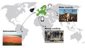
Globalisation and international trade allow us to consume produce from all over the world. But this comes at a cost to the environment – but, for the first time, satellite data combined with artificial intelligence is being usedtoprovide information to assess the impact of global supply chains.
Finding the value of AR, VR in process automation
11.9.2019 14:52 Bentley SystemsPress Coverage
Control Magazine, USA
Read the articleVYOM Designs Unique Office Building in Western India
11.9.2019 14:45 Bentley SystemsPress Coverage
Civil + Structural Engineer, USA
Read the articleMDA Selected to Design, Manufacture Advanced Navigation Antennas for Airbus Defence and Space
11.9.2019 14:42 GISCafe.com Webcasts-Webinars MONTREAL — (BUSINESS WIRE) — September 10, 2019 —MDA, a Maxar company (NYSE:MAXR) (TSX:MAXR), today announced that it will design …
Satellite Earth Observation (EO) Remains a Satellite Industry Growth Driver as Focus Shifts from Imagery to Insights
11.9.2019 14:42 GISCafe.com Webcasts-Webinars CAMBRIDGE, Mass., Sept. 11, 2019 (GLOBE NEWSWIRE) -- NSR’s Satellite-Based Earth Observation (EO), 11th Edition report, released today, projects …Benefits of AR, VR in process automation
11.9.2019 14:38 Bentley SystemsPress Coverage
Control Magazine, USA
Read the articleRoad-SIT Survey v. 7.5: The features that streamline the survey work
11.9.2019 13:08 GISCafe.com Webcasts-Webinars 10 September, 2019, Bologna Italy – SITECO Infomatica SRL will be attending Intergeo 2019 in Stuttgart, Hall 3, Stand B3.025, …Master Class 3: Airspace integration – Safe integration of drones into airspace
11.9.2019 12:41 GISCafe.com Webcasts-Webinars Stuttgart/Braunschweig/Karlsruhe, 10 September 2019: European airspace is densely populated. Especially in the vicinity of metropolitan regions, …Zpravodaj ČKS 3/2019
11.9.2019 12:18 Česká kartografická společnost Vyšlo třetí letošní číslo Zpravodaje ČKS. Na další číslo se můžete těšit v Kutné Hoře na 23. kartografické konferenci, kde vyjde Konferenční speciál.Geomatika pro stavebnictví – pozvánka na seminář Asociace podnikatelů v geomatice
11.9.2019 12:08 ZeměměřičAsociace podnikatelů v geomatice, připravila odborný seminář Geomatika pro stavebnictví. Akce je pořádána pod záštitou prezidenta Svazu podnikatelů ve stavebnictví Ing. Jiřího Nouzy. Seminář je věnovaný efektivnímu řízení stavebních strojů a moderním metodám hromadného sběru dat pro víceúčelové použití. Účastníky seznámí s danými tématy specialisté Ing. Petr Pracný (GEFOS a.s.) a Ing. Zbyněk Kugler (GRID, a.s.). Akce se koná […]
The post Geomatika pro stavebnictví – pozvánka na seminář Asociace podnikatelů v geomatice appeared first on Zeměměřič.
Geomatika pro stavebnictví – pozvánka na seminář Asociace podnikatelů v geomatice
11.9.2019 12:08 ZeměměřičAsociace podnikatelů v geomatice, připravila odborný seminář Geomatika pro stavebnictví. Akce je pořádána pod záštitou prezidenta Svazu podnikatelů ve stavebnictví Ing. Jiřího Nouzy. Seminář je věnovaný efektivnímu řízení stavebních strojů a moderním metodám hromadného sběru dat pro víceúčelové použití. Účastníky seznámí s danými tématy specialisté Ing. Petr Pracný (GEFOS a.s.) a Ing. Zbyněk Kugler (GRID, a.s.). Akce se koná […]
The post Geomatika pro stavebnictví – pozvánka na seminář Asociace podnikatelů v geomatice appeared first on Zeměměřič.
Geomatika ve stavebnictví – pozvánka na seminář Asociace podnikatelů v geomatice
11.9.2019 12:08 ZeměměřičAsociace podnikatelů v geomatice, připravila odborný seminář Geomatika pro stavebnictví. Akce je pořádána pod záštitou prezidenta Svazu podnikatelů ve stavebnictví Ing. Jiřího Nouzy. Seminář je věnovaný efektivnímu řízení stavebních strojů a moderním metodám hromadného sběru dat pro víceúčelové použití. Účastníky seznámí s danými tématy specialisté Ing. Petr Pracný (GEFOS a.s.) a Ing. Zbyněk Kugler (GRID, a.s.). Akce se koná […]
The post Geomatika ve stavebnictví – pozvánka na seminář Asociace podnikatelů v geomatice appeared first on Zeměměřič.
Geomatika pro stavebnictví. Seminář APG (nejen) pro členy Svazu podnikatelů ve stavebnictví
11.9.2019 11:49 Asociace podnikatelů v geomatice Asociace podnikatelů v geomatice, připravila odborný seminář Geomatika pro stavebnictví. Akce je pořádána pod záštitou prezidenta SPS Ing. Jiřího Nouzy. Seminář je věnovaný efektivnímu řízení stavebních strojů a moderním metodám hromadného sběru dat pro víceúčelové použití. S danými tématy účastníky seznámí specialisté Ing. Petr Pracný (GEFOS a.s.) a Ing. Zbyněk Kugler (GRID, a.s.). Akce se koná ve středu 2. října […]Geomatika pro stavebnictví. Seminář APG (nejen) pro členy Svazu podnikatelů ve stavebnitctví
11.9.2019 11:49 Asociace podnikatelů v geomatice Asociace podnikatelů v geomatice, připravila odborný seminář Geomatika pro stavebnictví. Akce je pořádána pod záštitou prezidenta SPS Ing. Jiřího Nouzy. Seminář je věnovaný efektivnímu řízení stavebních strojů a moderním metodám hromadného sběru dat pro víceúčelové použití. S danými tématy účastníky seznámí specialisté Ing. Petr Pracný (GEFOS a.s.) a Ing. Zbyněk Kugler (GRID, a.s.). Akce se koná ve středu […]Geomatika pro stavebnictví. Seminář APG (nejen) pro členy Svazu podnikatelů ve stavebnictví
11.9.2019 11:49 Asociace podnikatelů v geomatice Asociace podnikatelů v geomatice, připravila odborný seminář Geomatika pro stavebnictví. Akce je pořádána pod záštitou prezidenta SPS Ing. Jiřího Nouzy. Seminář je věnovaný efektivnímu řízení stavebních strojů a moderním metodám hromadného sběru dat pro víceúčelové použití. S danými tématy účastníky seznámí specialisté Ing. Petr Pracný (GEFOS a.s.) a Ing. Zbyněk Kugler (GRID, a.s.). Akce se koná ve středu […]Geomatika pro stavebnictví. Seminář APG (nejen) pro členy Svazu podnikatelů ve stavebnitctví
11.9.2019 11:49 Asociace podnikatelů v geomatice Asociace podnikatelů v geomatice, připravila odborný seminář Geomatika pro stavebnictví. Akce je pořádána pod záštitou prezidenta SPS Ing. Jiřího Nouzy. Seminář je věnovaný efektivnímu řízení stavebních strojů a moderním metodám hromadného sběru dat pro víceúčelové použití. S danými tématy účastníky seznámí specialisté Ing. Petr Pracný (GEFOS a.s.) a Ing. Zbyněk Kugler (GRID, a.s.). Akce se koná ve středu 2. října […]20190911 - omezení EPVDS
11.9.2019 11:42 ČÚZK - předpisy a opatření Katastrální úřad pro Karlovarský kraj zveřejnil novou aktualitu: Provozní informace KÚ - Řešení nedostupnosti/omezené funkcionality aplikace EPVDSV současné době se všechny Katastrální úřady a Katastrální pracoviště potýkají se s provozními problémy informačního systému zpracovávajícího datové zprávy z datových schránek a vypravování pošty. Na problému se intenzivně pracuje.
Děkujeme za pochopení.
20190911 - omezení EPVDS
11.9.2019 11:42 ČÚZK /Urady/Katastralni-urady/Katastralni-urady/Katastralni-urad-pro-Karlovarsky-kraj/O-uradu/Aktuality/20190911-omezeni-EPVDSNemoforum pořádá seminář o digitální mapě veřejné správy
11.9.2019 9:58 GeoBusiness Sdružení Nemoforum pořádá u příležitosti dvacátého výročí svého založení seminář o projektu Digitální mapy veřejné správy. Akce se koná v pátek 18. října 2019 v Choceradech (Hotel Akademie Naháč, Komorní Hrádek 277, 257 24 Chocerady). Program semináře, který organizátoři pojmenovali „Využijeme šance vybudovat digitální mapu veřejné správy?“, je následující Digitální technická mapa krajů, Mgr. Jiří […]Nemoforum pořádá seminář o digitální mapě veřejné správy
11.9.2019 9:58 GeoBusiness Sdružení Nemoforum pořádá u příležitosti dvacátého výročí svého založení seminář o projektu Digitální mapy veřejné správy. Akce se koná v pátek 18. října 2019 ... PřečístHlavní řečníci Konference GIS Esri v ČR
11.9.2019 9:51 ARCDATANa letošní Konferenci GIS Esri v ČR se můžete opět těšit na nabitý program. V úvodním bloku přednášek vystoupí:
- RNDr. Radim Tolasz, Ph.D.; přední český klimatolog, člen Světové meteorologické organizace a Mezivládního panelu pro změnu klimatu
- prof. Ing. Mgr. Miroslav Trnka, Ph.D.; bioklimatolog zabývající se matematickým modelováním a experimenty zaměřenými na studium dopadů změny klimatu a adaptačních možností
- prof. Mgr. Miroslav Bárta, Dr.; egyptolog a archeolog studující vztah člověka a krajiny ve starověku a vývoj a kolaps komplexních společností
Mimo to na vás bude čekat na plno uživatelských přednášek z oblasti veřejné správy, inženýrských sítí, životního prostředí a DPZ. Nebude však chybět ani stánek technické podpory, postery, soutěž v poznávání družicových snímků, tematické minisemináře a mnoho dalšího.

Program 25. semináře o katastru nemovitostí
11.9.2019 9:34 ZeměměřičSpolek zeměměřičů Brno zve na celostátní odborný diskusní seminář KATASTR NEMOVITOSTÍ XXV. Akce se koná v Třebíči 3. října 2019 (hotel Atom, Velkomeziříčská 640/45, Třebíč). Na programu letošního semináře budou přednášky Vliv změn v jednacím řádu katastrálního úřadu na zápisy do katastru nemovitostí, Mgr. Jiří Fojtášek (Katastrální úřad pro Jihomoravský kraj) Aktuální judikatura v oblasti věcných břemen, problematika nezbytné […]
The post Program 25. semináře o katastru nemovitostí appeared first on Zeměměřič.
Trimble GIS Express představí nové GNSS na Androidu, dron DJI Enterprise a další novinky pro práci s GIS daty
11.9.2019 9:28 GeoBusiness Ve dnech 10. října v Brně a 11. října v Praze se bude konat další ročník konference Trimble GIS Express, věnující se technologiím pro ... PřečístRevize v k.ú. Litoměřice
11.9.2019 8:28 ČÚZK - předpisy a opatření Katastrální úřad pro Ústecký kraj - Katastrální pracoviště Litoměřicezveřejnil novou aktualitu: Vážení klienti, oznamujeme Vám, že od 2.12.2019 - do 1.12.2022 bude probíhat v katastrálním území Litoměřice obce Litoměřice revize katastru nemovitostí. Účelem provádění revize je soulad údajů katastru nemovitostí se skutečným stavem v terénu, kdy jsou zjišťovány změny a ověřován dosavadní stav předmětu evidence katastru nemovitostí.
Revize v k.ú. Litoměřice
11.9.2019 8:28 ČÚZK /Urady/Katastralni-urady/Katastralni-urady/Katastralni-urad-pro-Ustecky-kraj/Katastralni-pracoviste/KP-Litomerice/O-uradu/Aktuality/Revize-v-k-u-LitomericeRevize v k.ú. Lovečkovice
11.9.2019 8:26 ČÚZK - předpisy a opatření Katastrální úřad pro Ústecký kraj - Katastrální pracoviště Litoměřicezveřejnil novou aktualitu: Vážení klienti, oznamujeme Vám, že od 2.12.2019 - do 7.9.2020 bude probíhat v katastrálním území Lovečkovice obce Lovčkovice revize katastru nemovitostí. Účelem provádění revize je soulad údajů katastru nemovitostí se skutečným stavem v terénu, kdy jsou zjišťovány změny a ověřován dosavadní stav předmětu evidence katastru nemovitostí.
Revize v k.ú. Lovečkovice
11.9.2019 8:26 ČÚZK - předpisy a opatření Katastrální úřad pro Ústecký kraj - Katastrální pracoviště Litoměřicezveřejnil novou aktualitu: Vážení klienti, oznamujeme Vám, že od 2.12.2019 - do 7.9.2020 bude probíhat v katastrálním území Lovečkovice obce Lovečkovice revize katastru nemovitostí. Účelem provádění revize je soulad údajů katastru nemovitostí se skutečným stavem v terénu, kdy jsou zjišťovány změny a ověřován dosavadní stav předmětu evidence katastru nemovitostí.
Revize v k.ú. Lovečkovice
11.9.2019 8:26 ČÚZK /Urady/Katastralni-urady/Katastralni-urady/Katastralni-urad-pro-Ustecky-kraj/Katastralni-pracoviste/KP-Litomerice/O-uradu/Aktuality/Revize-v-k-u-LoveckoviceRevize v k.ú. Chotiměř
11.9.2019 8:25 ČÚZK - předpisy a opatření Katastrální úřad pro Ústecký kraj - Katastrální pracoviště Litoměřicezveřejnil novou aktualitu: Vážení klienti, oznamujeme Vám, že od 1.11.2019 - do 29.5.2020 bude probíhat v katastrálním území Chotiměř obce Chotiměř revize katastru nemovitostí. Účelem provádění revize je soulad údajů katastru nemovitostí se skutečným stavem v terénu, kdy jsou zjišťovány změny a ověřován dosavadní stav předmětu evidence katastru nemovitostí.
Revize v k.ú. Chotiměř
11.9.2019 8:25 ČÚZK - předpisy a opatření Katastrální úřad pro Ústecký kraj - Katastrální pracoviště Litoměřicezveřejnil novou aktualitu: Vážení klienti, oznamujeme Vám, že od 1.11.2019 - do 29.5.2020 bude probíhat v katastrálním území Chotiměř obce Chotiměřrevize katastru nemovitostí. Účelem provádění revize je soulad údajů katastru nemovitostí se skutečným stavem v terénu, kdy jsou zjišťovány změny a ověřován dosavadní stav předmětu evidence katastru nemovitostí.