


![]()

zprávy
zdroje zpráv:AGI Appoints Robert Cardillo to Board of Directors
24.7.2019 18:47 GISCafe.com Webcasts-Webinars Former NGA director joins Board at AGIEXTON, Pa., July 24, 2019 — (PRNewswire) — Analytical Graphics …
ENVI Analytics Symposium - See the Future of Remote Sensing and Analytics
24.7.2019 18:43 GISCafe.com Webcasts-WebinarsOdborný referent – zápisy v řízení V a Z v oddělení právních vztahů k nemovitostem
24.7.2019 16:29 ČÚZK /Urady/Katastralni-urady/Katastralni-urady/Katastralni-urad-pro-Zlinsky-kraj/Uredni-deska/Oznameni-a-jina-uredni-sdeleni/Volna-mista/Odborny-referent-–-zapisy-v-rizeni-V-a-Z-v-odd-(1)Odborný referent – zápisy v řízení V a Z v oddělení právních vztahů k nemovitostem
24.7.2019 16:29 ČÚZK - předpisy a opatření Katastrální úřad pro Zlínský kraj - Katastrální pracoviště Valašské Meziříčívypisuje výběrové řízení na místo
Odborný referent – zápisy v řízení V a Z v oddělení právních vztahů k nemovitostem
Odborný referent – zápisy v řízení V a Z v oddělení právních vztahů k nemovitostem
24.7.2019 16:29 ČÚZK - volná místa Katastrální úřad pro Zlínský kraj - Katastrální pracoviště Valašské Meziříčí vypisuje výběrové řízení na místo Odborný referent – zápisy v řízení V a Z v oddělení právních vztahů k nemovitostemExpanding our knowledge of Arctic Ocean bathymetry
24.7.2019 12:08 ESA Observing the Earth
Our knowledge of the depth and shape of the Arctic Ocean floor – its bathymetry – is insufficient. Owing to year-round sea-ice coverage and the cost of research in this remote region, much of the Arctic Ocean’s bathymetry has remained a mystery, until now.
Master Class 4: Vertical Mobility in Urban Environments – Challenges and Success Factors
24.7.2019 10:21 GISCafe.com Webcasts-Webinars Stuttgart/Braunschweig/Karlsruhe, 23 July 2019 -- Vertical mobility is seen in many ways as a key technology and solutions provider for future …První milion leteckých snímků
24.7.2019 9:35 TopGis K dnešnímu dni naše společnost pořídila a zpracovala první milion leteckých měřických snímků. Jde přesně o 1 002 261 snímků. Pro představu – území České republiky je pokryto cca 100 tisíci snímky. Při zpracování ortofotomapy, stereofotogrammetrickém mapování a dalších činnostech spojených s výrobou dat z letecké fotogrammetrie máme některá data uložená na serverech v různýchOGC invites you to its CityGML Challenge
24.7.2019 9:23 GISCafe.com Webcasts-Webinars Help to create visualization tools that support CityGML 3 and you could land a £5,000 cash prize23 July 2019: The Open Geospatial …
Sanjay Gangal interviews Tom Counts, CEO, Co Founder from 3-GIS at ESRI UC 2019
24.7.2019 9:00 GISCafe.com Webcasts-WebinarsGIS Outdoor Libereckého kraje
24.7.2019 7:46 Asociace podnikatelů v geomatice Další ročník akce GIS OUTDOOR Ústeckého kraje 2019 se letos koná 8. a 9. října 2019 v areálu výstaviště Zahrady Čech v Litoměřicích. Vedle již diskutovaných témat GIS, dronů, územního plánování, leteckého a mobilního snímkování se tentokrát organizátoři také chtějí věnovat aktuálnímu tématu – Digitální technické mapě ČR. Více informací včetně kompletního programu naleznete zde.Přihlašte se na GIS v plánování měst a regionů 2019
24.7.2019 7:00 Česká asociace pro geoinformacePřihlašte se na GIS v plánování měst a regionů 2019
Česká asociace pro geoinformace (CAGI) a Vysoká škola regionální rozvoje a Bankovní institut - AMBIS, a.s. Vás srdečně zvou k účasti na 5. ročníku konference GIS v plánování měst a regionů, která se uskuteční v Praze v termínu 19. září 2019 v budově vysoké školy AMBIS: Lindnerova 575/1, Praha 8.
Tématem
APGEO - GIS OUTDOOR LIBERECKÉHO KRAJE
24.7.2019 2:00 Asociace podnikatelů v geomatice Další ročník akce GIS OUTDOOR Ústeckého kraje 2019 se letos koná 8. a 9. října 2019 v areálu výstaviště Zahrady Čech ...Třetí evropský servisní modul lodi Orion sveze kosmonauty na Měsíc
23.7.2019 20:06 Český Kosmický PortálNASA a ESA mají dlouhodobý plán, v němž počítají s Evropou coby dodavatelem servisního modulu ESM (European Service Modules) pro kosmickou loď Orion. Poté, co NASA oznámila svůj záměr vyslat člověka zpět na Měsíc před koncem roku 2024, bylo zároveň rozhodnuto, že se třetí vyrobený ESM bude na tomto letu podílet.
Velodyne Lidar Acquires Mapper.ai for ADAS Launch
23.7.2019 19:31 GISCafe.com Webcasts-Webinars Velodyne adds Mapper’s mapping and localization software to advance revolutionary lidar-centric ADASSAN JOSE, Calif. — (BUSINESS WIRE) …
CSAA Insurance Group Partners with Cape Analytics to Improve Home Inspections
23.7.2019 19:31 GISCafe.com Webcasts-Webinars Insurer Increased Underwriting Quality and Efficiency by Utilizing Cape Analytics’ AI-Based Property IntelligenceWALNUT CREEK, Calif. — …
Geospatial Media announces Location Analytics & Business Intelligence Advisory Board
23.7.2019 16:57 GISCafe.com Webcasts-Webinars Noida, 23 July 2019 – Geospatial Media and Communications, the premier geospatial knowledge company exclusively dedicated to promoting and …Schneider Electric Releases White Paper to Promote One-Planet Compatibility Ahead of Earth Overshoot Day
23.7.2019 16:57 GISCafe.com Webcasts-Webinars - New research indicates digital energy and infrastructure upgrades can push back the Earth Overshoot date by three weeksBOSTON, July 23, 2019 …
Mapbox and Sparkgeo Announce Web Map Analytics Integration
23.7.2019 16:57 GISCafe.com Webcasts-Webinars San Francisco, California, July 23, 2019 (GLOBE NEWSWIRE) -- Mapbox and Sparkgeo today announced a new integration of Sparkgeo’s web map …Sanborn Awarded Blanket Purchase Agreement from the GSA and the NGA to Provide Earth-Observation Products, Data and Services to Government Customers
23.7.2019 16:57 GISCafe.com Webcasts-Webinars COLORADO SPRINGS, Colo. — (BUSINESS WIRE) — July 23, 2019 —Sanborn, a leader in professional mapping and GIS products and …
Concept3D Announces Boca Center as Latest Retail Location to Launch its Immersive Map Platform
23.7.2019 16:57 GISCafe.com Webcasts-Webinars New Interactive Map Highlights Potential of Concept3D Platform to Showcase Retail, Malls, Restaurants and HotelsDENVER, July 23, 2019 — …
Odborný referent – zápisy v řízení V a Z v oddělení právních vztahů k nemovitostem
23.7.2019 15:49 ČÚZK - volná místa Katastrální úřad pro Zlínský kraj - Katastrální pracoviště Uherský Brod vypisuje výběrové řízení na místo Odborný referent – zápisy v řízení V a Z v oddělení právních vztahů k nemovitostemOdborný referent – zápisy v řízení V a Z v oddělení právních vztahů k nemovitostem
23.7.2019 15:49 ČÚZK - předpisy a opatření Katastrální úřad pro Zlínský kraj - Katastrální pracoviště Uherský Brodvypisuje výběrové řízení na místo
Odborný referent – zápisy v řízení V a Z v oddělení právních vztahů k nemovitostem
Second laser boosts Aeolus power
23.7.2019 14:40 ESA Observing the Earth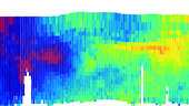
ESA’s Aeolus satellite, which carries the world’s first space Doppler wind lidar, has been delivering high-quality global measurements of Earth’s wind since it was launched almost a year ago. However, part of the instrument, the laser transmitter, has been slowly losing energy. As a result, ESA decided to switch over to the instrument’s second laser – and the mission is now back on top form.
OneWeb Satellites and partners OneWeb and Airbus transform space industry with world’s first high-volume satellite production facility in Florida
23.7.2019 10:12 GISCafe.com Webcasts-Webinars Opening marks a breakthrough in technology and manufacturing, enabling first-ever rapid production of communication satellitesSupports …
Galileo Demo Centre Hanoi – only a few spaces left!
23.7.2019 9:59 European GNSS Agency
Space is in high demand in the Galileo Demo Centre, opened at the NAVIS Centre in Hanoi by the BELS+ project. The Demo Centre provides European companies with a venue to showcase their GNSS-based solutions to stakeholders from South East Asia, and BELS+ is offering vouchers to interested companies to support the installation of their products in the Centre. The call to apply is closing soon, so don’t miss out!
BELS+ aims to develop GNSS markets for EU companies and help EU GNSS applications gain a foothold in South East Asia. With this aim in mind, the project opened the Galileo Demo Centre at the NAVIS Centre in Hanoi, Vietnam, as a venue where European companies can showcase their GNSS-based solutions.
The Demo Centre offers companies the opportunity to establish business relations in the SEA region and provides a venue to promote their GNSS-based products and services as well as to find the right business partners and potential customers in the South East Asia region.
Read this: BELS Builds Bridges to Southeast Asia
Given these benefits, it is no surprise that demand for space in the Centre is high, and several European companies are already showcasing or preparing the presentation of their products and solutions in the Demo Centre. These include: Septentrio (Belgium), NSL and Spirent (UK), SpacEarth and SpaceExe (Italy), ANavS, navXperience, TeleOrbit and IFEN (Germany), marXact (the Netherlands), and Bluecover and TeroMovigo (Portugal).
What’s on offer?
BELS+ has opened a call for companies interested in space in the Galileo Demo Centre. The project is offering interested companies vouchers to support the installation of their products. Successful applicants will receive up to EUR 2,500 to cover travel and accommodation expenses in Hanoi and up to EUR 3,000 to cover expenses connected with setting up their demos, such as shipping costs and import duties.
The call to apply for a voucher is closing soon, so don’t miss out! For more information and to apply, click here.
About BELS+
BELS - Building European Links towards Southeast Asia - was set up in 2015 and extended, as BELS+, in 2018 to facilitate the breakthrough of EGNSS technology in the South East Asian (SEA) market. Funded under Horizon 2020, BELS+ conducts a range of coordinated activities to raise awareness and build capacities for the exploitation of EGNSS technologies in South East Asia.
And this: Exporting Galileo – developing EGNSS markets outside Europe
The BELS+ consortium brings together partners from Europe and South East Asia, including European companies with a presence in the region, as well as leading universities. Together, these partners concentrate on three core objectives:
- Opening new markets to EU companies;
- Increasing awareness of EGNSS technology through workshops;
- Increasing the technical expertise of people in the region.
One of the project’s core aims is to promote Galileo and demonstrate how it can benefit the region. This work is particularly important as the SEA region lacks its own satellite navigation capabilities and is therefore dependent on other national or regional systems.
For more information, visit the project portal.
Media note: This feature can be republished without charge provided the European GNSS Agency (GSA) is acknowledged as the source at the top or the bottom of the story. You must request permission before you use any of the photographs on the site. If you republish, we would be grateful if you could link back to the GSA website (http://www.gsa.europa.eu).
OGC and RTCA Announce Signing of Memorandum of Understanding
23.7.2019 9:52 GISCafe.com Webcasts-Webinars July 23, 2019 -- The Open Geospatial Consortium (OGC) and RTCA, Inc. are pleased to announce the signing of a memorandum of understanding (MOU) …Pozvánka na 23. kartografickou konferenci
23.7.2019 9:30 ARCDATAČeská kartografická společnost vás ve spolupráci s katedrou aplikované geoinformatiky a kartografie PřF UK a katedrou geomatiky ČVUT zvou na 23. kartografickou konferenci. Ta se uskuteční 18.–20. září 2019 v Kutné Hoře. Program letošního ročníku se zaměří především na následující témata:
- Teoretické aspekty současné kartografie
- Praktická a komerční kartografie
- Vzdělávání v kartografii a školská kartografie
- Uživatelské aspekty kartografických děl
- Webová kartografie
- Kartografie ve státním sektoru
- Otevřená data a open source v kartografii
- Historická kartografie a stará mapová díla
- Aplikovaná kartografie v přírodních i společenských vědách
- Aktuální technologické trendy v kartografii
Zajímáte se o kartografii? Pak určitě neváhejte a registrujte sena stránkách konference. Termín pro přihlášení je 18. srpna 2019.
Reportáž z konference naleznete i v příštím vydání časopisu ArcRevue, který je mediálním partnerem této konference.

Sanjay Gangal interviews Rebecca Lasica, Executive VP from Harris Corp. at ESRI UC 2019
23.7.2019 9:00 GISCafe.com Webcasts-WebinarsMapová aplikace ÚAP - aktualizace
23.7.2019 7:20 Jihočeský kraj Mapová aplikace Územně analytické podklady byla aktualizována k 22.7.2019.Investiční akce
23.7.2019 2:00 Cenia - Katalog metadat ČR - INSPIRE Investiční akce ve Zlínském kraji z Odboru investic KÚZKMaxar Chosen by NASA to Integrate Pollution Monitoring Payload on an Upcoming Commercial Satellite
23.7.2019 0:29 GISCafe.com Webcasts-Webinars Innovative TEMPO instrument will measure major air pollutants over North America at each hour of the dayWESTMINSTER, Colo. — (BUSINESS WIRE) …
Maxar Technologies Second Quarter 2019 Investor Call Scheduled for Tuesday, August 6, 2019
22.7.2019 16:53 GISCafe.com Webcasts-Webinars WESTMINSTER, Colo. — (BUSINESS WIRE) — July 22, 2019 — Maxar Technologies (NYSE:MAXR) (TSX:MAXR) plans to release its second …Lenovo announces 2019 Big Back to School Sale – US
22.7.2019 16:52 GISCafe.com Webcasts-Webinars Three money-saving offers for students, parents and deal-seekersRESEARCH TRIANGLE PARK, N.C. — (BUSINESS WIRE) — July 22, 2019 …
Successful AirBox Drone Delivery Tests Conducted in Antigua
22.7.2019 16:52 GISCafe.com Webcasts-Webinars Drone Delivery Systems performs world's first BVLOS, autonomous flight, delivering into a secure mailbox in AntiguaLEWES, Del., July 22, 2019 …
Kosmonaut Luca Parmitano se vrátil na Mezinárodní kosmickou stanici
22.7.2019 12:32 Český Kosmický PortálKosmonaut ESA Luca Parmitano dorazil na Mezinárodní kosmickou stanici. Stalo se tak po šestihodinovém letu. Společně s ním na orbitální základnu přiletěli v lodi Sojuz MS-13 astronaut NASA Andrew Morgan a ruský kosmonaut Alexander Skvorcov. Přílet znamená počátek Expedice 60 a druhý dlouhodobý pobyt Lucy Parmitana na ISS. Jeho jméno je tentokrát „Beyond“.
Monitoring Earth’s skin heat for crops and climate
22.7.2019 10:15 ESA Observing the Earth
A bright red twin-engined aircraft, equipped with ultra-high-resolution thermal imaging technology has been scouring the agricultural heartlands of Europe this summer. It was no search and rescue exercise, but an initial step towards building a proposed new satellite system capable of recording the temperature of Earth’s skin in intricate detail.
Inspektor/ka – právník Zeměměřického a katastrálního inspektorátu v Praze
22.7.2019 10:10 ČÚZK - předpisy a opatření Zeměměřický a katastrální inspektorát v Prazevypisuje výběrové řízení na místo
Inspektor/ka – právník Zeměměřického a katastrálního inspektorátu v Praze
Inspektor/ka – právník Zeměměřického a katastrálního inspektorátu v Praze
22.7.2019 10:10 ČÚZK /Urady/Zememericke-a-katastralni-inspektoraty/Zememericke-a-katastralni-inspektoraty/Zememericky-a-katastralni-inspektorat-v-Praze/Uredni-deska/Oznameni-a-jina-uredni-sdeleni/Volna-mista/DMS/Inspektor-ka-–-pravnik-Zememerickeho-a-katastralniInspektor/ka – právník Zeměměřického a katastrálního inspektorátu v Praze
22.7.2019 10:10 ČÚZK - volná místa Zeměměřický a katastrální inspektorát v Praze vypisuje výběrové řízení na místo Inspektor/ka – právník Zeměměřického a katastrálního inspektorátu v PrazeVýběrové řízení inspektor/ka - právník (ZKI v Praze)
22.7.2019 10:06 ČÚZK - předpisy a opatření Zeměměřický a katastrální inspektorát v Praze zveřejnil novou aktualitu: Oznámení o vyhlášení výběrového řízení na služební místo inspektor/ka – právník Zeměměřického a katastrálního inspektorátu v Praze (obor služby 70.)Výběrové řízení inspektor/ka - právník (ZKI v Praze)
22.7.2019 10:06 ČÚZK - předpisy a opatření Zeměměřický a katastrální inspektorát v Praze zveřejnil novou aktualitu: Oznámení o vyhlášení výběrového řízení na služební místo inspektor/ka – právník Zeměměřického a katastrálního inspektorátu v Praze (obor služby 70.)20190722_VŘ_právník_ZKI_Praha
22.7.2019 10:01 ČÚZK - předpisy a opatření Zeměměřický a katastrální inspektorát v Prazevypisuje výběrové řízení na místo
Inspektor/ka - právník Zeměměřického a katastrálního inspektorátu v Praze (obor služby 55.)
20190722_VŘ_právník_ZKI_Praha
22.7.2019 10:01 ČÚZK /Urady/Zememericke-a-katastralni-inspektoraty/Zememericke-a-katastralni-inspektoraty/Zememericky-a-katastralni-inspektorat-v-Praze/Uredni-deska/Oznameni-a-jina-uredni-sdeleni/Volna-mista/DMS/20190722_VR_pravnik_ZKI_Praha20190722_VŘ_právník_ZKI_Praha
22.7.2019 10:01 ČÚZK - volná místa Zeměměřický a katastrální inspektorát v Praze vypisuje výběrové řízení na místo 20190722_VŘ_právník_ZKI_PrahaInterview with Sabrina Carter, Sales Enablement Manager from HP at ESRI UC 2019
22.7.2019 9:00 GISCafe.com Webcasts-WebinarsRada/odborný rada v oddělení právních vztahů k nemovitostem na Katastrálním pracovišti Znojmo
22.7.2019 7:45 ČÚZK - předpisy a opatření Katastrální úřad pro Jihomoravský kraj - Katastrální pracoviště Znojmovypisuje přijímací řízení na služební místo
Rada/odborný rada v oddělení právních vztahů k nemovitostem na Katastrálním pracovišti Znojmo
Rada/odborný rada v oddělení právních vztahů k nemovitostem na Katastrálním pracovišti Znojmo
22.7.2019 7:45 ČÚZK /Urady/Katastralni-urady/Katastralni-urady/Katastralni-urad-pro-Jihomoravsky-kraj/Volna-mista/Rada-odborny-rada-v-oddeleni-pravnich-vztahu-k-nemRada/odborný rada v oddělení právních vztahů k nemovitostem na Katastrálním pracovišti Znojmo
22.7.2019 7:45 ČÚZK - volná místa Katastrální úřad pro Jihomoravský kraj - Katastrální pracoviště Znojmo vypisuje výběrové řízení na místo Rada/odborný rada v oddělení právních vztahů k nemovitostem na Katastrálním pracovišti Znojmo"Pitney Bowes Announces PBLocator Geocoding for ArcGIS" by Susan Smith
21.7.2019 10:02 GISCafe.com Webcasts-WebinarsPozvánka na workshop „BIM a stavební výrobky“
20.7.2019 7:37 Asociace podnikatelů v geomatice Ministerstvo průmyslu a obchodu ve spolupráci s Českou agenturou pro standardizaci připravuje na podzim workshop, jehož hlavním tématem bude zpráva o aktuálním stavu přípravy zákona o stavebních výrobcích. Hlavní témata workshopu jsou Aktuální stav přípravy zákona o stavebních výrobcích Výrobky v obou částech BIM – design i proces Výrobky na evropské úrovni – CPE (Construction Product Europe) BIM – CPR a určené normy […]APGEO - POZVÁNKA NA WORKSHOP „BIM A STAVEBNÍ VÝROBKY“
20.7.2019 2:00 Asociace podnikatelů v geomatice Ministerstvo průmyslu a obchodu ve spolupráci s Českou agenturou pro standardizaci připravuje na podzim workshop ...Airbus to run UK MOD’s land C4ISR test centre
19.7.2019 21:04 GISCafe.com Webcasts-Webinars London, 19 July 2019 – Airbus has agreed a five-year contract with the UK Ministry of Defence (MOD) to manage test and reference services to …OGC’s Dr. Nadine Alameh receives GeoIgnite’s inaugural ‘Diversity in Leadership’ award
19.7.2019 17:09 GISCafe.com Webcasts-Webinars OGC CEO recognized for her “extraordinary and unfailing commitment to diversity and inclusion in the workplace and surrounding …Hurricane Barry is Estimated to Have Caused Between $500 Million and $900 Million in Flood and Wind Losses, CoreLogic Analysis Shows
19.7.2019 17:09 GISCafe.com Webcasts-Webinars —Non-NFIP Insured Flood and Wind Losses are Between $300 Million and $600 Million—IRVINE, Calif. — (BUSINESS WIRE) — July 19, 2019 …
Message from GSA Executive Director, Carlo des Dorides
19.7.2019 15:55 European GNSS Agency
As members of the GNSS community, you are all undoubtedly aware of the recent technical incident that resulted in the temporary interruption of Galileo navigation and timing services.
The technical incident originated in the Galileo ground segment, affecting the calculation of time and orbit predictions which are used to compute the navigation message. The technical incident affected different elements of the ground facilities.
A team composed of GSA experts, industry, ESA and the Commission worked together 24/7 to address the incident, and Galileo Initial Services have now been restored. In particular, the dedication and work of our industrial partners has helped to achieve this result. Commercial users can already see signs of recovery of the Galileo navigation and timing services, although some fluctuations may be experienced until further notice.
The team is monitoring the quality of Galileo services to restore the Galileo timing and navigation services to their nominal levels. As soon as we gather all the technical elements and implement all necessary actions, we will provide more detailed information through our NAGU (Notice Advisory to Galileo Users) notifications to users.
All partners worked together to remedy the situation as soon as possible. We will set up an Independent Inquiry Board to identify the root causes of the incident. This will allow us to draw lessons for the management of a global operational system with several millions of users worldwide.
The Galileo system has grown stronger as a result of this experience, and we will continue to deliver Initial Services until full operational capability is declared. These challenging days have shown us how much you, the GNSS user community and stakeholders, rely on Galileo and how much you trust the Galileo system to deliver the services to support growth, business and sustainability. Europe and the world need a strong civil global satellite navigation system today more than ever.
Media note: This feature can be republished without charge provided the European GNSS Agency (GSA) is acknowledged as the source at the top or the bottom of the story. You must request permission before you use any of the photographs on the site. If you republish, we would be grateful if you could link back to the GSA website (http://www.gsa.europa.eu).
Message from GSA Executive Director, Carlo des Dorides
19.7.2019 15:55 European GNSS Agency
As members of the GNSS community, you are all undoubtedly aware of the recent technical incident that resulted in the temporary interruption of Galileo navigation and timing services.
The technical incident originated by an equipment malfunction in the Galileo ground infrastructure, affecting the calculation of time and orbit predictions which are used to compute the navigation message. The technical incident affected different elements of the ground facilities.
A team composed of GSA experts, industry, ESA and the Commission worked together 24/7 to address the incident, and Galileo Initial Services have now been restored. In particular, the dedication and work of our industrial partners has helped to achieve this result. Commercial users can already see signs of recovery of the Galileo navigation and timing services, although some fluctuations may be experienced until further notice.
The team is monitoring the quality of Galileo services to restore the Galileo timing and navigation services to their nominal levels. As soon as we gather all the technical elements and implement all necessary actions, we will provide more detailed information through our NAGU (Notice Advisory to Galileo Users) notifications to users.
All partners worked together to remedy the situation as soon as possible. We will set up an Independent Inquiry Board to identify the root causes of the incident. This will allow us to draw lessons for the management of a global operational system with several millions of users worldwide.
The Galileo system has grown stronger as a result of this experience, and we will continue to deliver Initial Services until full operational capability is declared. These challenging days have shown us how much you, the GNSS user community and stakeholders, rely on Galileo and how much you trust the Galileo system to deliver the services to support growth, business and sustainability. Europe and the world need a strong civil global satellite navigation system today more than ever.
Media note: This feature can be republished without charge provided the European GNSS Agency (GSA) is acknowledged as the source at the top or the bottom of the story. You must request permission before you use any of the photographs on the site. If you republish, we would be grateful if you could link back to the GSA website (http://www.gsa.europa.eu).
Message from GSA Executive Director, Carlo des Dorides
19.7.2019 15:55 European GNSS Agency
As members of the GNSS community, you are all undoubtedly aware of the recent technical incident that resulted in the temporary interruption of Galileo navigation and timing services.
The technical incident originated in the Galileo ground infrastructure equipment, affecting the calculation of time and orbit predictions which are used to compute the navigation message. The technical incident affected different elements of the ground facilities.
A team composed of GSA experts, industry, ESA and the Commission worked together 24/7 to address the incident, and Galileo Initial Services have now been restored. In particular, the dedication and work of our industrial partners has helped to achieve this result. Commercial users can already see signs of recovery of the Galileo navigation and timing services, although some fluctuations may be experienced until further notice.
The team is monitoring the quality of Galileo services to restore the Galileo timing and navigation services to their nominal levels. As soon as we gather all the technical elements and implement all necessary actions, we will provide more detailed information through our NAGU (Notice Advisory to Galileo Users) notifications to users.
All partners worked together to remedy the situation as soon as possible. We will set up an Independent Inquiry Board to identify the root causes of the incident. This will allow us to draw lessons for the management of a global operational system with several millions of users worldwide.
The Galileo system has grown stronger as a result of this experience, and we will continue to deliver Initial Services until full operational capability is declared. These challenging days have shown us how much you, the GNSS user community and stakeholders, rely on Galileo and how much you trust the Galileo system to deliver the services to support growth, business and sustainability. Europe and the world need a strong civil global satellite navigation system today more than ever.
Media note: This feature can be republished without charge provided the European GNSS Agency (GSA) is acknowledged as the source at the top or the bottom of the story. You must request permission before you use any of the photographs on the site. If you republish, we would be grateful if you could link back to the GSA website (http://www.gsa.europa.eu).
Freemap.sk má novú outdoorovú mapu s označenými vrstevnicami
19.7.2019 13:49 Geocommunity.skPríspevok Freemap.sk má novú outdoorovú mapu s označenými vrstevnicami zobrazený najskôr GeoCommunity.sk.
Freemap.sk má novú outdoorovú mapu s označenými vrstevnicami
19.7.2019 13:49 Geocommunity.skNovinkou na stránke Freemap.sk je vrstva mapy s názvom Nová Outdoorová. Zobrazuje hneď niekoľko trás naraz. Turista tu môže nájsť turistickú, cyklistickú, bežkársku ale dokonca aj lyžiarsku trasu, čo predstavuje značné vylepšenie oproti minulosti. Nová Outdoorová Nová Outdoorová vrstva pokrýva celé územie Slovenska, Česka, Maďarska a časti Poľska, Rakúska a Ukrajiny. Martin Ždila, tajomník občianskeho … … Čítať ďalej
Príspevok Freemap.sk má novú outdoorovú mapu s označenými vrstevnicami zobrazený najskôr GeoCommunity.sk.
Freemap.sk má novú outdoorovú mapu s označenými vrstevnicami
19.7.2019 13:49 Geocommunity.skPríspevok Freemap.sk má novú outdoorovú mapu s označenými vrstevnicami zobrazený najskôr GeoCommunity.sk.
Freemap.sk má novú outdoorovú mapu s označenými vrstevnicami
19.7.2019 13:49 Geocommunity.skPríspevok Freemap.sk má novú outdoorovú mapu s označenými vrstevnicami zobrazený najskôr GeoCommunity.sk.
Freemap.sk má novú outdoorovú mapu s označenými vrstevnicami
19.7.2019 13:49 Geocommunity.skPríspevok Freemap.sk má novú outdoorovú mapu s označenými vrstevnicami zobrazený najskôr GeoCommunity.sk.
Zveřejnění obsahu informací poskytnutých na žádost dle zákona č. 106/1999 Sb. za rok 20
19.7.2019 12:22 ČÚZK - předpisy a opatření Zeměměřický a katastrální inspektorát v Prazezveřejňuje obsah informace poskytnutých na žádost dle zákona č. 106/1999 Sb. za rok
2019
Zveřejnění obsahu informací poskytnutých na žádost dle zákona č. 106/1999 Sb. za rok 20
19.7.2019 12:22 ČÚZK /Urady/Zememericke-a-katastralni-inspektoraty/Zememericke-a-katastralni-inspektoraty/Zememericky-a-katastralni-inspektorat-v-Praze/Casto-hledane-informace/Poskytovani-informaci-106-1999-Sb/Zverejneni-obsahu-informaci-poskytnutych-na-za-(1)/Zverejneni-obsahu-informaci-poskytnutych-na-za-(1)Zveřejnění obsahu informací poskytnutých na žádost dle zákona č. 106/1999 Sb. za rok 2019
19.7.2019 12:22 ČÚZK - předpisy a opatření Zeměměřický a katastrální inspektorát v Prazezveřejňuje obsah informace poskytnutých na žádost dle zákona č. 106/1999 Sb. za rok
2019
Zveřejnění obsahu informací poskytnutých na žádost dle zákona č. 106/1999 Sb. za rok 2019
19.7.2019 12:22 ČÚZK /Urady/Zememericke-a-katastralni-inspektoraty/Zememericke-a-katastralni-inspektoraty/Zememericky-a-katastralni-inspektorat-v-Praze/Casto-hledane-informace/Poskytovani-informaci-106-1999-Sb/Zverejneni-obsahu-informaci-poskytnutych-na-za-(1)/Zverejneni-obsahu-informaci-poskytnutych-na-za-(1)Kovair Announces Partnership with PTC
19.7.2019 12:12 GISCafe.com Webcasts-Webinars San Ramon, California. July 11, 2019 -- Kovair Software, today announced the signing of a strategic partnership agreement with PTC, one of …Při odesílání GP pře
19.7.2019 11:41 GEUSware Při odesílání GP přes WSGP v programu GEUS je zapotřebí mít nainstalovanou verzi GEUS 23.0.3.222 a vyšší (instalace zde). Starší verze GEUSu (22.0 a níže) neumožňuje odesílání GP přes WSGP a vše se řeší přes e-mail, zde je tedy vhodné doporučení katastru respektovat a použít také poslední verzi programu KDirSign 4.0.
Palm oil plantations
19.7.2019 10:05 ESA Observing the Earth
Earth observation image of the week: Copernicus Sentinel-2 captures palm oil plantations in East Kalimantan - the Indonesian part of the island Borneo
Earth from Space
19.7.2019 10:05 ESA Observing the Earth
In this edition, the Copernicus Sentinel-2 mission takes us over palm oil plantations on the island of Borneo
Sanjay Gangal interviews Michael Eggenberger, VP of Critigen at ESRI UC 2019
19.7.2019 9:00 GISCafe.com Webcasts-WebinarsEuropa Technologies strikes gold with two awards at Esri User Conference
19.7.2019 9:00 GISCafe.com Webcasts-Webinars 15 July 2019 -- Europa Technologies has won two awards at the Esri User Conference 2019 in San Diego, California. Both awards were given to a …ESA identifikuje poptávku po družicích u Měsíce
19.7.2019 8:27 Český Kosmický PortálV následující dekádě se chystají k Měsíci desítky různých komerčních a vládních misí.
25. seminář Katastr nemovitostí - termín
19.7.2019 7:00 Česká asociace pro geoinformace Spolek zeměměřičů Brno Vás srdečně na seminář Katastr nemovitostí XXV., sterý se uskuteční 3. října 2019 v Třebíči. Bližší informace brzyHustota OSM a červencový mapathon
19.7.2019 7:00 Česká asociace pro geoinformace Disaster Ninja je mapa hustoty OpenStreetMap, která zobrazuje počet zmapovaných objektů OpenStreetMap ve srovnání s hustotou zalidnění.Pomoci při doplnění slabě zmapovaných míst můžete i vy! Navštivte například nejbližší Missing maps mapathon v červenci v
Selhání nosiče Vega během letu VV15: Arianespace a ESA vytvořily nezávislou vyšetřovací komisi
18.7.2019 19:48 Český Kosmický PortálSpolečnost Arianespace oznámila, že start rakety Vega VV15 11. července 2019 nesoucí družici FalconEye1, se skončil havárií. Jde o první selhání nosiče po čtrnácti úspěšných startech v řadě od roku 2012, kdy začala Vega létat do vesmíru z evropského kosmodromu ve Francouzské Guayaně.
Researchers bust cost barriers by putting $100 satellites into orbit
18.7.2019 19:44 GISCafe.com Webcasts-Webinars Chip-sized satellites, or ChipSats, are designed to work together in a swarm to perform tasks that, nowadays, only big, costly systems can do.A …
Mapbox and Yahoo! JAPAN Collaborate to Transform the Digital Experience of Maps in Japan
18.7.2019 17:29 GISCafe.com Webcasts-Webinars San Francisco, California and Tokyo, Japan, July 18, 2019 (GLOBE NEWSWIRE) -- Mapbox and Yahoo Japan Corporation (hereafter referred to as …CoreLogic Special Report: The Role of Housing in the Longest Economic Expansion
18.7.2019 17:29 GISCafe.com Webcasts-Webinars —A 121-Month Evaluation on How the Nation’s Real Estate Market Has Impacted the Economy—IRVINE, Calif. — (BUSINESS WIRE) — July …
Červencový Missing Maps mapathon v Praze – v Operu (pozvánka)
18.7.2019 12:37 GISportal.cz
Přijďte a podpořte práci humanitárních organizací tím, že pomůžete zmapovat místa, která jsou nejvíce ohrožena krizemi. Mapathon společně organizují Lékaři bez hranic a Český červený kříž. Srdečně zveme úplné začátečníky i ty, kdo už mapovat umí. Co se na setkání bude dít? Na Mapathonu budeme společně podle satelitních snímků vytvářet v OpenStreetMap mapu pro týmy Lékařů bez hranic […]
The post Červencový Missing Maps mapathon v Praze – v Operu (pozvánka) appeared first on GISportal.cz.
Galileo Initial Services have now been restored
18.7.2019 11:46 European GNSS Agency
Galileo Initial Services have now been restored. Commercial users can already see signs of recovery of the Galileo navigation and timing services, although some fluctuations may be experienced until further notice.
The technical incident originated by an equipment malfunction in the Galileo ground infrastructure, affecting the calculation of time and orbit predictions, and which are used to compute the navigation message. The malfunction affected different elements on the ground facilities.
A team composed of GSA experts, industry, ESA and Commission, worked together 24/7 to address the incident. The team is monitoring the quality of Galileo services to restore Galileo timing and navigation services at their nominal levels.
We will set an Independent Inquiry Board to identify the root causes of the major incident. This will allow the Commission, as the programme manager, together with the EU Agency GSA to draw lessons for the management of an operational system with several millions of users worldwide.
Galileo provides ‘initial services’ since December 2016. During this initial ‘pilot’ phase preceding the ‘full operational services’ phase, Galileo signals are used in combination with other satellite navigation systems, which allows for the detection of technical issues before the system becomes fully operational. In the full operational phase, Galileo should function independently of other satellite navigation systems.
Dedicated Notice Advisory to Galileo Users (NAGUs) have been published at the European GNSS Service Centre to inform users on the service impact:
• NAGU number 2019025 on 2019-07-11 14:45 on the potential service degradation;
• NAGU number 2019026 on 2019-07-13 20:15 on the service outage;
• NAGU number 2019027 on 2019-07-18 08:20 on the service recovery;
as well as a news item on the GSA website on 14 July and 17 July .
Media note: This feature can be republished without charge provided the European GNSS Agency (GSA) is acknowledged as the source at the top or the bottom of the story. You must request permission before you use any of the photographs on the site. If you republish, we would be grateful if you could link back to the GSA website (http://www.gsa.europa.eu).
Galileo Initial Services have now been restored
18.7.2019 11:46 European GNSS AgencyGalileo Initial Services have now been restored. Commercial users can already see signs of recovery of the Galileo navigation and timing services, although some fluctuations may be experienced until further notice.
The technical incident originated by a malfunction in the ground segment, affecting the calculation of time and orbit predictions, and which are used to compute the navigation message. The malfunction affected different elements on the ground facilities.
A team composed of GSA experts, industry, ESA and Commission, worked together 24/7 to address the incident. The team is monitoring the quality of Galileo services to restore Galileo timing and navigation services at their nominal levels.
We will set an Independent Inquiry Board to identify the root causes of the major incident. This will allow the Commission, as the programme manager, together with the EU Agency GSA to draw lessons for the management of an operational system with several millions of users worldwide.
Galileo provides ‘initial services’ since December 2016. During this initial ‘pilot’ phase preceding the ‘full operational services’ phase, Galileo signals are used in combination with other satellite navigation systems, which allows for the detection of technical issues before the system becomes fully operational. In the full operational phase, Galileo should function independently of other satellite navigation systems.
Dedicated Notice Advisory to Galileo Users (NAGUs) have been published at the European GNSS Service Centre to inform users on the service impact:
• NAGU number 2019025 on 2019-07-11 14:45 on the potential service degradation;
• NAGU number 2019026 on 2019-07-13 20:15 on the service outage;
• NAGU number 2019027 on 2019-07-18 08:20 on the service recovery;
as well as a news item on the GSA website on 14 July and 17 July .
Media note: This feature can be republished without charge provided the European GNSS Agency (GSA) is acknowledged as the source at the top or the bottom of the story. You must request permission before you use any of the photographs on the site. If you republish, we would be grateful if you could link back to the GSA website (http://www.gsa.europa.eu).
Galileo Initial Services have now been restored
18.7.2019 11:46 European GNSS AgencyGalileo Initial Services have now been restored. Commercial users can already see signs of recovery of the Galileo navigation and timing services, although some fluctuations may be experienced until further notice.
The technical incident originated by an equipment malfunction in the Galileo control centres that calculate time and orbit predictions, and which are used to compute the navigation message. The malfunction affected different elements on both centres.
A team composed of GSA experts, industry, ESA and Commission, worked together 24/7 to address the incident. The team is monitoring the quality of Galileo services to restore Galileo timing and navigation services at their nominal levels.
We will set an Independent Inquiry Board to identify the root causes of the major incident. This will allow the Commission, as the programme manager, together with the EU Agency GSA to draw lessons for the management of an operational system with several millions of users worldwide.
Galileo provides ‘initial services’ since December 2016. During this initial ‘pilot’ phase preceding the ‘full operational services’ phase, Galileo signals are used in combination with other satellite navigation systems, which allows for the detection of technical issues before the system becomes fully operational. In the full operational phase, Galileo should function independently of other satellite navigation systems.
Dedicated Notice Advisory to Galileo Users (NAGUs) have been published at the European GNSS Service Centre to inform users on the service impact:
• NAGU number 2019025 on 2019-07-11 14:45 on the potential service degradation;
• NAGU number 2019026 on 2019-07-13 20:15 on the service outage;
• NAGU number 2019027 on 2019-07-17 HH:MM on the service recovery;
as well as a news item on the GSA website on 14 July and 17 July .
Media note: This feature can be republished without charge provided the European GNSS Agency (GSA) is acknowledged as the source at the top or the bottom of the story. You must request permission before you use any of the photographs on the site. If you republish, we would be grateful if you could link back to the GSA website (http://www.gsa.europa.eu).
Galileo Initial Services have now been restored
18.7.2019 11:46 European GNSS AgencyGalileo Initial Services have now been restored. Commercial users can already see signs of recovery of the Galileo navigation and timing services, although some fluctuations may be experienced until further notice.
The technical incident originated by an equipment malfunction in the Galileo ground infrastructure, affecting the calculation of time and orbit predictions, and which are used to compute the navigation message. The malfunction affected different elements on the ground facilities.
A team composed of GSA experts, industry, ESA and Commission, worked together 24/7 to address the incident. The team is monitoring the quality of Galileo services to restore Galileo timing and navigation services at their nominal levels.
We will set an Independent Inquiry Board to identify the root causes of the major incident. This will allow the Commission, as the programme manager, together with the EU Agency GSA to draw lessons for the management of an operational system with several millions of users worldwide.
Galileo provides ‘initial services’ since December 2016. During this initial ‘pilot’ phase preceding the ‘full operational services’ phase, Galileo signals are used in combination with other satellite navigation systems, which allows for the detection of technical issues before the system becomes fully operational. In the full operational phase, Galileo should function independently of other satellite navigation systems.
Dedicated Notice Advisory to Galileo Users (NAGUs) have been published at the European GNSS Service Centre to inform users on the service impact:
• NAGU number 2019025 on 2019-07-11 14:45 on the potential service degradation;
• NAGU number 2019026 on 2019-07-13 20:15 on the service outage;
• NAGU number 2019027 on 2019-07-18 08:20 on the service recovery;
as well as a news item on the GSA website on 14 July and 17 July .
Media note: This feature can be republished without charge provided the European GNSS Agency (GSA) is acknowledged as the source at the top or the bottom of the story. You must request permission before you use any of the photographs on the site. If you republish, we would be grateful if you could link back to the GSA website (http://www.gsa.europa.eu).
Galileo Initial Services have now been restored
18.7.2019 11:46 European GNSS AgencyGalileo Initial Services have now been restored. Commercial users can already see signs of recovery of the Galileo navigation and timing services, although some fluctuations may be experienced until further notice.
The technical incident originated by an equipment malfunction in the Galileo control centres that calculate time and orbit predictions, and which are used to compute the navigation message. The malfunction affected different elements on both centres.
A team composed of GSA experts, industry, ESA and Commission, worked together 24/7 to address the incident. The team is monitoring the quality of Galileo services to restore Galileo timing and navigation services at their nominal levels.
We will set an Independent Inquiry Board to identify the root causes of the major incident. This will allow the Commission, as the programme manager, together with the EU Agency GSA to draw lessons for the management of an operational system with several millions of users worldwide.
Galileo provides ‘initial services’ since December 2016. During this initial ‘pilot’ phase preceding the ‘full operational services’ phase, Galileo signals are used in combination with other satellite navigation systems, which allows for the detection of technical issues before the system becomes fully operational. In the full operational phase, Galileo should function independently of other satellite navigation systems.
Dedicated Notice Advisory to Galileo Users (NAGUs) have been published at the European GNSS Service Centre to inform users on the service impact:
• NAGU number 2019025 on 2019-07-11 14:45 on the potential service degradation;
• NAGU number 2019026 on 2019-07-13 20:15 on the service outage;
• NAGU number 2019027 on 2019-07-18 08:20 on the service recovery;
as well as a news item on the GSA website on 14 July and 17 July .
Media note: This feature can be republished without charge provided the European GNSS Agency (GSA) is acknowledged as the source at the top or the bottom of the story. You must request permission before you use any of the photographs on the site. If you republish, we would be grateful if you could link back to the GSA website (http://www.gsa.europa.eu).
VŘ HR kontrola listin
18.7.2019 10:20 ČÚZK - předpisy a opatření Katastrální úřad pro Olomoucký kraj - Katastrální pracoviště Hranice zveřejnil novou aktualitu: Oznámení o vyhlášení výběrového řízení na služební místo rada/odborný rada – kontrola listin určených k záznamu, návrh zápisu v katastru, řízení o ORVŘ HR kontrola listin
18.7.2019 10:20 ČÚZK /Urady/Katastralni-urady/Katastralni-urady/Katastralni-urad-pro-Olomoucky-kraj/Katastralni-pracoviste/KP-Hranice/O-uradu/Aktuality/VR-HR-kontrola-listinVŘ HR
18.7.2019 10:17 ČÚZK /Urady/Katastralni-urady/Katastralni-urady/Katastralni-urad-pro-Olomoucky-kraj/O-uradu/Aktuality/VR-HRVŘ HR
18.7.2019 10:17 ČÚZK - předpisy a opatření Katastrální úřad pro Olomoucký kraj - Katastrální pracoviště Hranice zveřejnil novou aktualitu: Oznámení o vyhlášení výběrového řízení na služební místo rada/odborný rada – kontrola listin určených k záznamu, návrh zápisu v katastru, řízení o ORReplay: Earth Explorer 9
18.7.2019 10:15 ESA Observing the Earth
Relive the User Consultation Meeting, which forms a critical part of the decision-making process as to whether FORUM or SKIM will be ESA’s next Earth Explorer
referent KN – vedení DKM, vedení katastrální mapy
18.7.2019 9:48 ČÚZK - předpisy a opatření Katastrální úřad pro hlavní město Prahu zveřejnil novou aktualitu: Ředitel úřadu vyhlašuje výběrové řízení na služební místo:referent KN – vedení DKM, vedení katastrální mapy
referent KN – vedení DKM, vedení katastrální mapy
18.7.2019 9:48 ČÚZK /Urady/Katastralni-urady/Katastralni-urady/Katastralni-urad-pro-hlavni-mesto-Prahu/O-uradu/Aktuality/referent-KN-–-vedeni-DKM,-vedeni-katastralni-mapyreferent KN – vedení DKM, vedení katastrální mapy
18.7.2019 9:46 ČÚZK - volná místa Katastrální úřad pro hlavní město Prahu vypisuje výběrové řízení na místo referent KN – vedení DKM, vedení katastrální mapyreferent KN – vedení DKM, vedení katastrální mapy
18.7.2019 9:46 ČÚZK - předpisy a opatření Katastrální úřad pro hlavní město Prahuvypisuje výběrové řízení na místo
referent KN – vedení DKM, vedení katastrální mapy
referent KN – vedení DKM, vedení katastrální mapy
18.7.2019 9:46 ČÚZK /Urady/Katastralni-urady/Katastralni-urady/Katastralni-urad-pro-hlavni-mesto-Prahu/Uredni-deska/Oznameni-a-jina-uredni-sdeleni/Volna-mista/referent-KN-–-vedeni-DKM,-vedeni-katastralni-mapyreferent KN – vedení DKM, vedení katastrální mapy
18.7.2019 9:46 ČÚZK - předpisy a opatření Katastrální úřad pro hlavní město Prahu - Katastrální pracoviště Prahavypisuje výběrové řízení na místo
referent KN – vedení DKM, vedení katastrální mapy
referent KN – vedení DKM, vedení katastrální mapy
18.7.2019 9:46 ČÚZK - volná místa Katastrální úřad pro hlavní město Prahu - Katastrální pracoviště Praha vypisuje výběrové řízení na místo referent KN – vedení DKM, vedení katastrální mapyČÚZK přeruší provoz DP a WSDP
18.7.2019 9:33 GEPROČÚZK plánuje přerušit provoz Dálkového přístupu (DP) a Webových služeb dálkového přístupu (WSDP) v pátek 19.… >>
SA GEOTECH 2019
18.7.2019 4:18 Satlab GeosolutionsSatlab Geosolutions has partnered with SA GeoTech to sh […]
The post SA GEOTECH 2019 appeared first on Satlab – Global Satellite Positioning Solutions.
INTERGEO 2019
18.7.2019 4:18 Satlab GeosolutionsThe post INTERGEO 2019 appeared first on Satlab – Global Satellite Positioning Solutions.
SA GEOTECH 2019
18.7.2019 4:18 Satlab GeosolutionsSatlab Geosolutions has partnered with SA GeoTech to share mapping solutions to professionals. Join us in our event to unlock your mapping mobility. Date: 22 to 23 July 2019 (Mon – Tues) Venue: Emperors Palace, Ekurhuleni, South Africa
The post SA GEOTECH 2019 appeared first on Satlab – Global Satellite Positioning Solutions.
INTERGEO Digital 2020
18.7.2019 3:40 Satlab GeosolutionsFree Tickets to INTERGEO Digital 2020 From October 13 – 15 INTERGEO 2020 will take place for the first time as a purely digital event, over 200 brands and their solutions from GEO-IT, drones, BIM and Smart City will be there. Get your free tickets to INTERGEO 2020 now! Get your free 3-Day-EXPO-Ticket now and join […]
The post INTERGEO Digital 2020 appeared first on SatLab – Global Satellite Positioning Solutions.
Free Tickets to INTERGEO Digital 2020
18.7.2019 3:40 Satlab GeosolutionsFrom October 13 – 15 INTERGEO 2020 will take place for the first time as a purely digital event, over 200 brands and their solutions from GEO-IT, drones, BIM and Smart City will be there. Get your free tickets to INTERGEO now! Get your free 3-Day-EXPO-Ticket now and join us in the world’s biggest hub for […]
The post Free Tickets to INTERGEO Digital 2020 appeared first on SatLab – Global Satellite Positioning Solutions.
INTERGEO 2020
18.7.2019 3:40 Satlab GeosolutionsINTERGEO 2020 Free Ticket Registration This year’s INTERGEO will take place in Berlin, Germany, from 13 – 15 October 2020. Get your free ticket now and join us in the world’s biggest hub for the geospatial community. Satlab Geosolutions AB will showcase the full range of products, along with complete solutions of hardware and software. […]
The post INTERGEO 2020 appeared first on Satlab – Global Satellite Positioning Solutions.
INTERGEO Digital 2021
18.7.2019 3:40 Satlab GeosolutionsFree Tickets to INTERGEO Digital 2021 From October 13 – […]
The post INTERGEO Digital 2021 appeared first on SatLab – Global Satellite Positioning Solutions.
INTERGEO 2020 DIGITAL
18.7.2019 3:40 Satlab GeosolutionsThis year’s INTERGEO will take place in Berlin, Germany, from 13 – 15 October 2020. Satlab Geosolutions AB will showcase the full range of products, along with complete solutions of hardware and software. Our professional team will provide professional introductions as well as Q&A. The solutions will cover Machine Control, Monitoring, Indoor Positioning, Aerial Mapping, LiDAR, […]
The post INTERGEO 2020 DIGITAL appeared first on SatLab – Global Satellite Positioning Solutions.
INTERGEO 2020 DIGITAL
18.7.2019 3:40 Satlab GeosolutionsThis year’s INTERGEO will take place in Berlin, Germany, from 13 – 15 October 2020. Satlab Geosolutions AB will showcase the full range of products, along with complete solutions of hardware and software. Our professional team will provide professional introductions as well as Q&A. The solutions will cover Machine Control, Monitoring, Indoor Positioning, Aerial Mapping, LiDAR, […]
The post INTERGEO 2020 DIGITAL appeared first on Satlab – Global Satellite Positioning Solutions.
INTERGEO 2020
18.7.2019 3:40 Satlab GeosolutionsINTERGEO 2020 Free Ticket Registration This year’s INTERGEO will take place in Berlin, Germany, from 13 – 15 October 2020. Get your free ticket now and join us in the world’s biggest hub for the geospatial community. Satlab Geosolutions AB will showcase the full range of products, along with complete solutions of hardware and software. […]
The post INTERGEO 2020 appeared first on Satlab – Global Satellite Positioning Solutions.
INTERGEO Digital 2021
18.7.2019 3:40 Satlab GeosolutionsFree Tickets to INTERGEO Digital 2021 From October 13 – 15 INTERGEO 2021 will take place for the first time as a purely digital event, over 200 brands and their solutions from GEO-IT, drones, BIM and Smart City will be there. Get your free tickets to INTERGEO 2021 now! Get your free 3-Day-EXPO-Ticket now and join us […]
The post INTERGEO Digital 2021 appeared first on SatLab – Global Satellite Positioning Solutions.
INTERGEO 2019
18.7.2019 3:40 Satlab GeosolutionsINTERGEO 2019 Free Ticket Registration This year’ […]
The post INTERGEO 2019 appeared first on Satlab – Global Satellite Positioning Solutions.
Free Tickets to INTERGEO Digital 2020
18.7.2019 3:40 Satlab GeosolutionsFrom OCTOBER 13 – 15 INTERGEO 2020 will take place for the first time as a purely digital event, over 200 brands and their solutions from GEO-IT, drones, BIM and Smart City will be there. Get your free tickets to INTERGEO now! Get your free 3-Day-EXPO-Ticket now and join us in the world’s biggest hub for […]
The post Free Tickets to INTERGEO Digital 2020 appeared first on SatLab – Global Satellite Positioning Solutions.
INTERGEO Digital 2020
18.7.2019 3:40 Satlab GeosolutionsFree Tickets to INTERGEO 2020 From October 13 – 15 INTERGEO 2020 will take place for the first time as a purely digital event, over 200 brands and their solutions from GEO-IT, drones, BIM and Smart City will be there. Get your free tickets to INTERGEO 2020 now! Get your free 3-Day-EXPO-Ticket now and join us […]
The post INTERGEO Digital 2020 appeared first on SatLab – Global Satellite Positioning Solutions.
INTERGEO Digital 2020
18.7.2019 3:40 Satlab GeosolutionsFree Tickets to INTERGEO Digital 2020 From October 13 – […]
The post INTERGEO Digital 2020 appeared first on SatLab – Global Satellite Positioning Solutions.
INTERGEO 2020 DIGITAL
18.7.2019 3:40 Satlab GeosolutionsThis year’s INTERGEO will take place in Berlin, Germany, from 13 – 15 October 2020. Satlab Geosolutions AB will showcase the full range of products, along with complete solutions of hardware and software. Our professional team will provide professional introductions as well as Q&A. The solutions will cover Machine Control, Monitoring, Indoor Positioning, Aerial Mapping, LiDAR, […]
The post INTERGEO 2020 DIGITAL appeared first on Satlab – Global Satellite Positioning Solutions.
INTERGEO 2020 DIGITAL
18.7.2019 3:40 Satlab GeosolutionsThis year’s INTERGEO will take place in Berlin, Germany, from 13 – 15 October 2020. SatLab Geosolutions AB will showcase the full range of products, along with complete solutions of hardware and software. Our professional team will provide professional introductions as well as Q&A. The solutions will cover Machine Control, Monitoring, Indoor Positioning, Aerial Mapping, […]
The post INTERGEO 2020 DIGITAL appeared first on SatLab – Global Satellite Positioning Solutions.
Intergeo 2019 Stuttgart
18.7.2019 3:40 Satlab GeosolutionsThe post Intergeo 2019 Stuttgart appeared first on Satlab – Global Satellite Positioning Solutions.
INTERGEO 2020
18.7.2019 3:40 Satlab GeosolutionsINTERGEO 2020 Free Ticket Registration This year& […]
The post INTERGEO 2020 appeared first on Satlab – Global Satellite Positioning Solutions.