


![]()

zprávy
zdroje zpráv:Odborný referent - asistent/personalista v Katastrálním úřadu pro Moravskoslezský kraj
3.1.2019 15:15 ČÚZK - předpisy a opatření Katastrální úřad pro Moravskoslezský krajvypisuje výběrové řízení na místo
Odborný referent - asistent/personalista v Katastrálním úřadu pro Moravskoslezský kraj
Odborný referent - asistent/personalista v Katastrálním úřadu pro Moravskoslezský kraj
3.1.2019 15:15 ČÚZK - volná místa Katastrální úřad pro Moravskoslezský kraj vypisuje výběrové řízení na místo Odborný referent - asistent/personalista v Katastrálním úřadu pro Moravskoslezský krajVrchní referent/rada – obnova katastrálního operátu v technickém odboru Katastrálního úřadu pro Mora
3.1.2019 15:13 ČÚZK - volná místa Katastrální úřad pro Moravskoslezský kraj - technický odbor vypisuje výběrové řízení na místo Vrchní referent/rada – obnova katastrálního operátu v technickém odboru Katastrálního úřadu pro MoraVrchní referent/rada – obnova katastrálního operátu v technickém odboru Katastrálního úřadu pro Mora
3.1.2019 15:13 ČÚZK - předpisy a opatření Katastrální úřad pro Moravskoslezský kraj - technický odborvypisuje výběrové řízení na místo
Vrchní referent/rada – obnova katastrálního operátu v technickém odboru Katastrálního úřadu pro Moravskoslezský kraj
Vrchní referent/rada – obnova katastrálního operátu v technickém odboru Katastrálního úřadu pro Mora
3.1.2019 15:13 ČÚZK /Urady/Katastralni-urady/Katastralni-urady/Katastralni-urad-pro-Moravskoslezsky-kraj/Uredni-deska/Oznameni-a-jina-uredni-sdeleni/Volna-mista/Vrchni-referent-rada-–-obnova-katastralniho-op-(1)Rada/odborný rada – správce informačních a komunikačních technologií v technickém odboru Katastrální
3.1.2019 15:11 ČÚZK - volná místa Katastrální úřad pro Moravskoslezský kraj - technický odbor vypisuje výběrové řízení na místo Rada/odborný rada – správce informačních a komunikačních technologií v technickém odboru KatastrálníRada/odborný rada – správce informačních a komunikačních technologií v technickém odboru Katastrální
3.1.2019 15:11 ČÚZK /Urady/Katastralni-urady/Katastralni-urady/Katastralni-urad-pro-Moravskoslezsky-kraj/Uredni-deska/Oznameni-a-jina-uredni-sdeleni/Volna-mista/Rada-odborny-rada-–-spravce-informacnich-a-komunikRada/odborný rada – správce informačních a komunikačních technologií v technickém odboru Katastrální
3.1.2019 15:11 ČÚZK - předpisy a opatření Katastrální úřad pro Moravskoslezský kraj - technický odborvypisuje výběrové řízení na místo
Rada/odborný rada – správce informačních a komunikačních technologií v technickém odboru Katastrálního úřadu pro Moravskoslezský kraj
Oznámení o vzniku nového katastrálního území
3.1.2019 9:22 ČÚZK - předpisy a opatření Katastrální úřad pro Jihočeský kraj - Katastrální pracoviště České Budějovice zveřejnil novou aktualitu:Oznámení o vzniku nového katastrálního území
Dne 2.1.2019 bylo v katastru nemovitostí v územní působnosti Katastrálního pracoviště České Budějovice vytvořeno nové k.ú. Strýčice (kód ČSÚ 738565), které vzniklo na základě dohody mezi Obcí Radošovice a Obcí Strýčice.
Oznámení o vzniku nového katastrálního území
3.1.2019 9:22 ČÚZK /Urady/Katastralni-urady/Katastralni-urady/Katastralni-urad-pro-Jihocesky-kraj/Katastralni-pracoviste/KP-Ceske-Budejovice/O-uradu/Aktuality/Oznameni-o-vzniku-noveho-katastralniho-uzemi20190102 odborný rada v oddělení právních vztahů k nemovitostem
3.1.2019 7:34 ČÚZK - předpisy a opatření Katastrální úřad pro Středočeský kraj - Katastrální pracoviště Mladá Boleslav Vyhlášení výběrového řízení: odborný rada v oddělení právních vztahů k nemovitostem V části "Úřední deska", v sekci "Oznámení a jiná úřední sdělení" bylo vystaveno "Oznámení o vyhlášení výběrového řízení na obsazení systemizovaného místa odborný rada v oddělení právních vztahů k nemovitostem"20190102 odborný rada v oddělení právních vztahů k nemovitostem
3.1.2019 7:34 ČÚZK /Urady/Katastralni-urady/Katastralni-urady/Katastralni-urad-pro-Stredocesky-kraj/Katastralni-pracoviste/KP-Mlada-Boleslav/O-uradu/Aktuality/20181220-Vrchni-referent-rada-oddeleni-aktuali-(1)odborný rada v oddělení právních vztahů k nemovitostem
3.1.2019 7:33 ČÚZK - volná místa Katastrální úřad pro Středočeský kraj - Katastrální pracoviště Mladá Boleslav vypisuje výběrové řízení na místo odborný rada v oddělení právních vztahů k nemovitostemodborný rada v oddělení právních vztahů k nemovitostem
3.1.2019 7:33 ČÚZK - předpisy a opatření Katastrální úřad pro Středočeský kraj - Katastrální pracoviště Mladá Boleslavvypisuje výběrové řízení na místo odborný rada v oddělení právních vztahů k nemovitostem
odborný rada v oddělení právních vztahů k nemovitostem
Rozpočet úřadu za rok 2019
3.1.2019 7:29 ČÚZK /Urady/Katastralni-urady/Katastralni-urady/Katastralni-urad-pro-Pardubicky-kraj/Rozpocet/Rozpocet-uradu-za-rok-2019Rozpočet úřadu za rok 2019
3.1.2019 7:29 ČÚZK - předpisy a opatření Katastrální úřad pro Pardubický krajvystavuje rozpočet úřadu za rok 2019
2019
15. historickogeografická konference „Stopy cest“ - program
3.1.2019 7:00 Česká asociace pro geoinformace Organizátoři 15. hisorickogeografické konference „Stopy cest“ (Výzkumné centrum historické geografie, komise pro historickou geografii a sekce Historické geografie a environmentálních dějin České geografické společnosti) zveřejnili program akce, která proběhne ve středu 23. ledna 2019 na Přírodovědecké fakultě Univerzity Karlovy.Více o konferenci se dozvíte v
Co nás čeká na obloze v roce 2019?
3.1.2019 7:00 Česká asociace pro geoinformace Astronomický ústav AV ČR přinesl na svém webu zajímavé shrnutí toho, co bude možné vidět na obloze v následujícím roce. Pokud patříte k fanouškům astronomie nebo se prostě jen rádi koukáte na hvězdy, rozhodně si neváhejte článekVolná místa v IPR
3.1.2019 7:00 Česká asociace pro geoinformaceInstitut plánování a rozvoje hlavního města Prahy nabízí následující zajímavé pracovní příležitosti:
PR specialista/specialistka (Sekce vnějších vztahů)
Specialista/specialistka na územně analytické podklady (Sekce plánování města)
Oborný specialista/odborná specialistka veřejného prostoru (Kancelář veřejného prostoru)
Institut plánování a rozvoje
Prohlížecí služba WMS - Data50
3.1.2019 1:00 Cenia - Katalog metadat ČR - INSPIRE Prohlížecí služba WMS-Data50 je poskytována jako veřejná prohlížecí služba nad daty topografické databáze České republiky Data50. Kartografická vizualizace objektů vychází z podoby Základní mapy 1:50 000. Služba může být využita jako vektorová podkladová mapa ČR pro měřítka od cca 1:60 000 do cca 1:25 000. Služba splňuje Technické pokyny pro INSPIRE prohlížecí služby v. 3.11 a zároveň splňuje standard OGC WMS 1.1.1. a 1.3.0.Vítězné nápady pro nové kosmické dopravní služby
2.1.2019 21:42 Český Kosmický PortálPřemisťování družic na vyšší oběžné dráhy, sbírání kosmické tříště nebo dedikované starty pro malé družice. To jsou vítězné nápady z výzvy ESA, které vybízela k předložení nápadů na nové komerční vesmírné dopravní služby.
CoreLogic Reports November Home Prices Increased by 5.1 Percent Year Over Year
2.1.2019 17:08 GISCafe.com Webcasts-Webinars Home-price growth projected to slow to 4.8 percent by November 2019November marked the eighth consecutive month of slowing …
Maxar Technologies Completes U.S. Domestication
2.1.2019 17:08 GISCafe.com Webcasts-Webinars WESTMINSTER, CO, Jan. 2, 2019 — (PRNewswire) — Maxar Technologies Inc. (NYSE:MAXR) (TSX:MAXR) ("Maxar" or the "Company"), a global …Rozpočet úřadu za rok 2019
2.1.2019 14:18 ČÚZK /Urady/Katastralni-urady/Katastralni-urady/Katastralni-urad-pro-Plzensky-kraj/Rozpocet/Rozpocet-uradu-za-rok-2019Rozpočet úřadu za rok 2019
2.1.2019 14:18 ČÚZK - předpisy a opatření Katastrální úřad pro Plzeňský krajvystavuje rozpočet úřadu za rok
2019
S novou verzí do nového roku
2.1.2019 12:28 GEPROZveřejnili jsme verze 14.12 našich produktů MISYS, MISYS-WEB – licenční server, KOKEŠ, a PROLAND.… >>
Výroční zpráva dle zákona č. 106/1999 Sb. za rok 2018
2.1.2019 11:12 ČÚZK - předpisy a opatření Zeměměřický a katastrální inspektorát v Brněvydává výroční zprávu úřadu za rok
2018
Výroční zpráva dle zákona č. 106/1999 Sb. za rok 2018
2.1.2019 11:12 ČÚZK /Urady/Zememericke-a-katastralni-inspektoraty/Zememericke-a-katastralni-inspektoraty/Zememericky-a-katastralni-inspektorat-v-Brne/Vyrocni-zpravy/Vyrocni-zprava-dle-zakona-c-106-1999-Sb-za-rok-2Rozpočet úřadu za rok 2019
2.1.2019 11:08 ČÚZK /Urady/Zememericke-a-katastralni-inspektoraty/Zememericke-a-katastralni-inspektoraty/Zememericky-a-katastralni-inspektorat-v-Brne/Rozpocet/Rozpocet-uradu-za-rok-2019Rozpočet úřadu za rok 2019
2.1.2019 11:08 ČÚZK - předpisy a opatření Zeměměřický a katastrální inspektorát v Brněvystavuje rozpočet úřadu za rok
2019
20190102 - Technický problém s VFR
2.1.2019 10:46 ČÚZK - předpisy a opatření Oznámení pro uživatele historického VFR:K 31.12.2018 se nevygeneroval historický stavový VFR. Technický problém v současné době analyzujeme a připravujeme opravu. Omlouváme se za způsobené potíže.
Zveřejněno 2. 1. 2019
20190102 - Technický problém s VFR
2.1.2019 10:46 ČÚZK /Uvod/Produkty-a-sluzby/RUIAN/2-Poskytovani-udaju-RUIAN-ISUI-VDP/Vymenny-format-RUIAN/Archiv-novinek-VFR/20190102-Technicky-problem-s-VFR2019
2.1.2019 10:38 ČÚZK /Urady/Zememericke-a-katastralni-inspektoraty/Zememericke-a-katastralni-inspektoraty/Zememericky-a-katastralni-inspektorat-v-Pardubicic/Rozpocet/20192019
2.1.2019 10:38 ČÚZK - předpisy a opatření Zeměměřický a katastrální inspektorát v Pardubicíchvystavuje rozpočet úřadu za rok
2019
2018
2.1.2019 10:37 ČÚZK /Urady/Zememericke-a-katastralni-inspektoraty/Zememericke-a-katastralni-inspektoraty/Zememericky-a-katastralni-inspektorat-v-Pardubicic/Vyrocni-zpravy/Vyrocni-zprava-dle-zakona-c-106-1999-Sb-za-rok-22018
2.1.2019 10:37 ČÚZK - předpisy a opatření Zeměměřický a katastrální inspektorát v Pardubicíchvydává výroční zprávu úřadu za rok
2018
Rozpočet úřadu za rok 2019
2.1.2019 10:23 ČÚZK - předpisy a opatření Zeměměřický a katastrální inspektorát v Plznivystavuje rozpočet úřadu za rok
2019
Rozpočet úřadu za rok 2019
2.1.2019 10:23 ČÚZK /Urady/Zememericke-a-katastralni-inspektoraty/Zememericke-a-katastralni-inspektoraty/Zememericky-a-katastralni-inspektorat-v-Plzni/Rozpocet/Rozpocet-uradu-za-rok-2019Zveřejnění obsahu informací poskytnutých na žádost dle zákona č. 106/1999 Sb. za rok 20
2.1.2019 10:14 ČÚZK /Urady/Zememericke-a-katastralni-inspektoraty/Zememericke-a-katastralni-inspektoraty/Zememericky-a-katastralni-inspektorat-v-Pardubicic/Casto-hledane-informace/Poskytovani-informaci-106-1999-Sb/Zverejneni-obsahu-informaci-poskytnutych-na-za-(1)/Zverejneni-obsahu-informaci-poskytnutych-na-zadostZveřejnění obsahu informací poskytnutých na žádost dle zákona č. 106/1999 Sb. za rok 20
2.1.2019 10:14 ČÚZK - předpisy a opatření Zeměměřický a katastrální inspektorát v Pardubicíchzveřejňuje obsah informace poskytnutých na žádost dle zákona č. 106/1999 Sb. za rok
2019
Rozpočet úřadu za rok 2019
2.1.2019 9:57 ČÚZK - předpisy a opatření Zeměměřický a katastrální inspektorát v Českých Budějovicíchvystavuje rozpočet úřadu za rok
2019
Rozpočet úřadu za rok 2019
2.1.2019 9:57 ČÚZK /Urady/Zememericke-a-katastralni-inspektoraty/Zememericke-a-katastralni-inspektoraty/Zememericky-a-katastralni-inspektorat-v-CB/Rozpocet/Rozpocet-uradu-za-rok-2019Přejeme vše nejlepší v novém roce 2019
2.1.2019 9:53 UpVision Přejeme všechno nejlepší a úspěšný nový rok 2019, v kterém máme opět velké cíle. :-)Zveřejnění obsahu informací poskytnutých na žádost dle zákona č. 106/1999 Sb. za rok 2019
2.1.2019 9:49 ČÚZK /Urady/Zememericke-a-katastralni-inspektoraty/Zememericke-a-katastralni-inspektoraty/Zememericky-a-katastralni-inspektorat-v-CB/Casto-hledane-informace/Poskytovani-informaci-106-1999-Sb/Zverejneni-obsahu-informaci-poskytnutych-na-za-(1)/Zverejneni-obsahu-informaci-poskytnutych-na-zadostZveřejnění obsahu informací poskytnutých na žádost dle zákona č. 106/1999 Sb. za rok 2019
2.1.2019 9:49 ČÚZK - předpisy a opatření Zeměměřický a katastrální inspektorát v Českých Budějovicíchzveřejňuje obsah informace poskytnutých na žádost dle zákona č. 106/1999 Sb. za rok
2019
Výroční zpráva dle zákona č. 106/1999 Sb. za rok 2018
2.1.2019 9:45 ČÚZK - předpisy a opatření Zeměměřický a katastrální inspektorát v Českých Budějovicíchvydává výroční zprávu úřadu za rok
2018
Výroční zpráva dle zákona č. 106/1999 Sb. za rok 2018
2.1.2019 9:45 ČÚZK /Urady/Zememericke-a-katastralni-inspektoraty/Zememericke-a-katastralni-inspektoraty/Zememericky-a-katastralni-inspektorat-v-CB/Vyrocni-zpravy/Vyrocni-zprava-dle-zakona-c-106-1999-Sb-za-rok-220190102 - Aktualizace dokumentů
2.1.2019 8:46 ČÚZK - předpisy a opatření V části "Dokumentace" byla v průběhu prosince 2018 zaktualizována většina dokumentů k WS.20190102 - Aktualizace dokumentů
2.1.2019 8:46 ČÚZK /Uvod/Produkty-a-sluzby/RUIAN/1-Editacni-agendovy-system-ISUI/Editacni-webove-sluzby-ISUI/Archiv-novinky/20190102-Aktualizace-dokumentuRozpočet úřadu za rok 2019
2.1.2019 7:37 ČÚZK /Urady/Katastralni-urady/Katastralni-urady/Katastralni-urad-pro-Liberecky-kraj/Rozpocet/Rozpocet-uradu-za-rok-2019Rozpočet úřadu za rok 2019
2.1.2019 7:37 ČÚZK - předpisy a opatření Katastrální úřad pro Liberecký krajvystavuje rozpočet úřadu za rok
2019
Dny geografie 2019
2.1.2019 7:00 Česká asociace pro geoinformaceDny geografie 2019
Seznam akcí, které se připojily k letošnímu ročníku Dnů geografie, se pomalu rozrůstá. Dny Geografie 2019 proběhnou jako již tradičně v listopadu, a to ve dnech 11.- 22.11. 2019. Chcete se zúčastnit některé z akcí nebo ji dokonce pořádat? Tak neváhejte a navštivte stránky dnygeografie.cz.
Seznam akcí, které se připojily k letošnímu ročníku
HxGN LOCAL ČESKO A SLOVENSKO 2019
1.1.2019 18:00 Hexagon Safety & Infrastructure Hotel Zámek ValečČeská republika, Valeč
19. června, 09:00 dop. - 20. června, 18:00 odp.
Prolistujte si aktuální vydání Zeměměřiče 7-10/2018
1.1.2019 10:01 Zeměměřič Prolistujte si aktuální vydání Zeměměřiče 7-10/2018, které má 116 stran.Drone Aviation Reaches Agreement to Eliminate Over 70% of Existing Debt, Supporting Planned Growth
1.1.2019 9:00 GISCafe.com Webcasts-Webinars Jacksonville,FL, Dec. 27, 2018 (GLOBE NEWSWIRE) -- Drone Aviation Holding Corp. (OTCQB: DRNE) (“Drone Aviation” or the …PF 2019
31.12.2018 1:37 Asociace podnikatelů v geomatice Asociace podnikatelů v geomatice děkuje všem členům za dosavadní spolupráci a přeje úspěšný rok 2019.APGEO - PF 2019
31.12.2018 1:00 Asociace podnikatelů v geomatice Asociace podnikatelů v geomatice děkuje všem členům za dosavadní spolupráci a přeje úspěšný rok 2019.Case IH, STEYR and New Holland Agriculture equipment is now compatible with the Galileo satellite network
29.12.2018 9:06 European GNSS Agency, Spain, to discuss the performance achieved using the last available GNSS equipment for auto-steering applications.")
CNH Industrial, a global leader in the capital goods sector, has enhanced the robustness of the precision agriculture systems for its global agricultural brands, Case IH, STEYR and New Holland Agriculture, by adding Galileo signals to their reference network solution.
During November’s EIMA International Agricultural and Gardening Machinery Exhibit in Bologna, Italy, Case IH, STEYR and New Holland announced that their equipment will now be Galileo-capable, enhancing the robustness of the RTK correction services.
This RTK guided auto-steering and its related technology ensures a fast, dependable signal and sub 1.5 cm repeatable accuracy in all conditions, regardless of field location. However, until now, farmers have had to depend on non-civilian American GPS or Russian GLONASS signals when driving in the field. “Enhanced RTK accuracy through the incorporation of signals from the Galileo satellites is a core way in which we can help Case IH tractor and combine users be innovative and competitive as they seek to help develop sustainable agricultural practices to feed an ever-increasing world population in an environmentally responsible way,” says Dan Stuart, Product Marketing Director EMEA Case IH.

For Maxime Rocaboy, Product Marketing EMEA at STEYR, the benefits of the enhanced RTK correction services are quite clear: “Use of the Galileo satellite navigation system, which is extremely accurate and available almost everywhere, enables a whole new range of options for farmers and contractors. It gives them detailed information on their land and crops like never before and realises all the potential benefits of the STEYR auto steering systems.”
The addition of Galileo signals also helps minimise the risk of signal failure, which is one of the major reasons why the Case IH, STEYR and New Holland CNH Industrial RTK networks are integrating corrections from Galileo satellites. “By improving positioning and timing information, consistency of signal coverage is enhanced and a robust and reliable signal for accurate pass-to-pass repeatability is ensured,” says Alessio Quatraro, Product Marketing Manager EMEA at New Holland Agriculture. Michael Mahieu, CNH Industrial RTK network analyst, “This benefits farmers by minimising downtime and assist in consistent and efficient use of seed, fertiliser and crop protection products through parallel passes with minimal overlap, thereby maximising a crop’s potential.”

The addition of Galileo signals means a higher number of available satellites when using RTK corrections, making the service even more robust – especially under challenging circumstances such as working under trees, in forestry or in orchards. The company is currently testing and validating Galileo correction signals for its RTK corrective service, which are expected to be available on the market starting in January 2019.
Galileo drives European competitiveness
The use of GNSS technology, including Galileo, is opening new business models and opportunities in the agricultural sector. GNSS-based precision farming gives farmers an unprecedented level of knowledge about their crops, livestock and operations while making the sector more efficient, economically competitive and environmentally sustainable.
According to the European GNSS Agency (GSA), Galileo provides improved positioning and timing information, with significant positive implications for many European farmers. “Galileo is well-positioned to enhance the GNSS performance, allowing users to benefit from an improved monitoring of the distribution and dilution of chemicals, improved parcel yields thanks to customised treatment and more efficient property management,” says Joaquín Reyes, who has prepared the the so-called User Consultation Platform, Agriculture panel, in Marseille early December where Precision Agriculture plays a central role. CNH Industrial participated in this event along with other leading tractor and machinery manufacturers.
EU Space Week
CNH Industrial N.V. (NYSE: CNHI / MI: CNHI) is a global leader in the capital goods sector with established industrial experience, a wide range of products and a worldwide presence. Each of the individual brands belonging to the Company is a major international force in its specific industrial sector: Case IH, New Holland Agriculture and Steyr for tractors and agricultural machinery; Case and New Holland Construction for earth moving equipment; Iveco for commercial vehicles; Iveco Bus and Heuliez Bus for buses and coaches; Iveco Astra for quarry and construction vehicles; Magirus for firefighting vehicles; Iveco Defence Vehicles for defence and civil protection; and FPT Industrial for engines and transmissions. More information can be found on the corporate website: www.cnhindustrial.com
Media note: This feature can be republished without charge provided the European GNSS Agency (GSA) is acknowledged as the source at the top or the bottom of the story. You must request permission before you use any of the photographs on the site. If you republish, we would be grateful if you could link back to the GSA website (http://www.gsa.europa.eu).
Case IH, STEYR and New Holland Agriculture equipment is now compatible with the Galileo satellite network
29.12.2018 9:06 European GNSS Agency, Spain, to discuss the performance achieved using the last available GNSS equipment for auto-steering applications.")
CNH Industrial, a global leader in the capital goods sector, has enhanced the robustness of the precision agriculture systems for its global agricultural brands, Case IH, STEYR and New Holland Agriculture, by adding Galileo signals to their reference network solution.
During November’s EIMA International Agricultural and Gardening Machinery Exhibit in Bologna, Italy, Case IH, STEYR and New Holland announced that their equipment will now be Galileo-capable, enhancing the robustness of the RTK correction services.
This RTK guided auto-steering and its related technology ensures a fast, dependable signal and sub 1.5 cm repeatable accuracy in all conditions, regardless of field location. However, until now, farmers have had to depend on non-civilian American GPS or Russian GLONASS signals when driving in the field. “Enhanced RTK accuracy through the incorporation of signals from the Galileo satellites is a core way in which we can help Case IH tractor and combine users be innovative and competitive as they seek to help develop sustainable agricultural practices to feed an ever-increasing world population in an environmentally responsible way,” says Dan Stuart, Product Marketing Director EMEA Case IH.
For Maxime Rocaboy, Product Marketing EMEA at STEYR, the benefits of the enhanced RTK correction services are quite clear: “Use of the Galileo satellite navigation system, which is extremely accurate and available almost everywhere, enables a whole new range of options for farmers and contractors. It gives them detailed information on their land and crops like never before and realises all the potential benefits of the STEYR auto steering systems.”
The addition of Galileo signals also helps minimise the risk of signal failure, which is one of the major reasons why the Case IH, STEYR and New Holland CNH Industrial RTK networks are integrating corrections from Galileo satellites. “By improving positioning and timing information, consistency of signal coverage is enhanced and a robust and reliable signal for accurate pass-to-pass repeatability is ensured,” says Alessio Quatraro, Product Marketing Manager EMEA at New Holland Agriculture. Michael Mahieu, CNH Industrial RTK network analyst, “This benefits farmers by minimising downtime and assist in consistent and efficient use of seed, fertiliser and crop protection products through parallel passes with minimal overlap, thereby maximising a crop’s potential.”
The addition of Galileo signals means a higher number of available satellites when using RTK corrections, making the service even more robust – especially under challenging circumstances such as working under trees, in forestry or in orchards. The company is currently testing and validating Galileo correction signals for its RTK corrective service, which are expected to be available on the market starting in January 2019.
Galileo drives European competitiveness
The use of GNSS technology, including Galileo, is opening new business models and opportunities in the agricultural sector. GNSS-based precision farming gives farmers an unprecedented level of knowledge about their crops, livestock and operations while making the sector more efficient, economically competitive and environmentally sustainable.
According to the European GNSS Agency (GSA), Galileo provides improved positioning and timing information, with significant positive implications for many European farmers. “Galileo is well-positioned to enhance the GNSS performance, allowing users to benefit from an improved monitoring of the distribution and dilution of chemicals, improved parcel yields thanks to customised treatment and more efficient property management,” says Joaquín Reyes, who has prepared the the so-called User Consultation Platform, Agriculture panel, in Marseille early December where Precision Agriculture plays a central role. CNH Industrial participated in this event along with other leading tractor and machinery manufacturers.
EU Space Week
CNH Industrial N.V. (NYSE: CNHI / MI: CNHI) is a global leader in the capital goods sector with established industrial experience, a wide range of products and a worldwide presence. Each of the individual brands belonging to the Company is a major international force in its specific industrial sector: Case IH, New Holland Agriculture and Steyr for tractors and agricultural machinery; Case and New Holland Construction for earth moving equipment; Iveco for commercial vehicles; Iveco Bus and Heuliez Bus for buses and coaches; Iveco Astra for quarry and construction vehicles; Magirus for firefighting vehicles; Iveco Defence Vehicles for defence and civil protection; and FPT Industrial for engines and transmissions. More information can be found on the corporate website: www.cnhindustrial.com
Media note: This feature can be republished without charge provided the European GNSS Agency (GSA) is acknowledged as the source at the top or the bottom of the story. You must request permission before you use any of the photographs on the site. If you republish, we would be grateful if you could link back to the GSA website (http://www.gsa.europa.eu).
Problém obchodního cestujícího á la Santa Claus
29.12.2018 8:11 GISportal.cz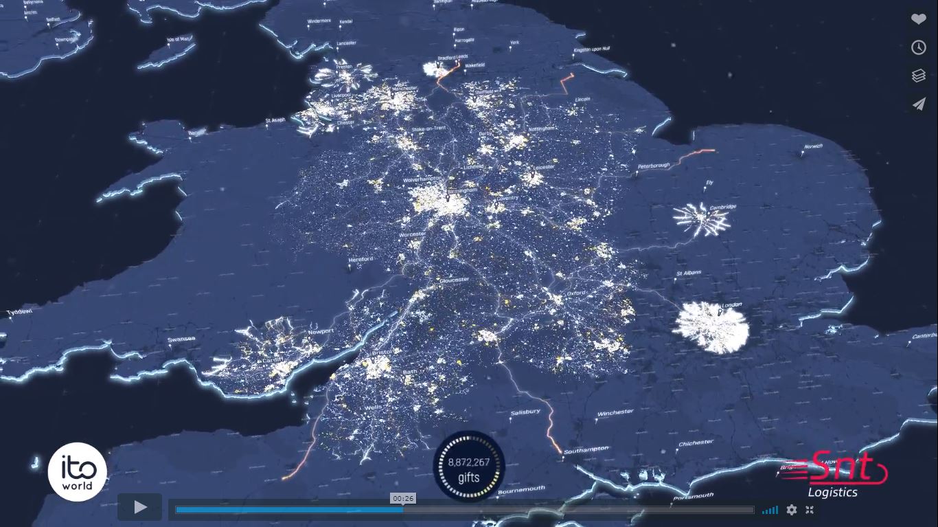
Pokud by měl Santa rozvážet cca 12 milionů dárku ve Velké Británii, vypadalo by to asi takto:
The post Problém obchodního cestujícího á la Santa Claus appeared first on GISportal.cz.
Problém obchodního cestujícího á la Santa Claus
29.12.2018 8:11 GISportal.czPokud by měl Santa rozvážet cca 12 milionů dárku ve Velké Británii, vypadalo by to asi takto:
The post Problém obchodního cestujícího á la Santa Claus appeared first on GISportal.cz.
Pozvánka na 12. sjezd ČSGK
29.12.2018 7:00 Česká asociace pro geoinformacePozvánka na 12. sjezd ČSGK
Český svaz geodetů a kartografů zve členy na 12. sjezd svazu, který se uskuteční v sobotu 8. února 2020 od 13:00 hodin v Ostravě (Nová aula VŠB - TUO). Na sjezd navazuje večer od 19:00 12. ples zeměměřičů.
Více informací včetně registrace naleznete na webových stránkách VŠB-TUO.
Český svaz geodetů a kartografů zve členy na 12.
Siemens and Bentley Systems introduce digital twin cloud services
28.12.2018 16:33 Bentley SystemsPress Coverage
Converter News, USA
Read the articleConceptual design for HS2
28.12.2018 16:26 Bentley SystemsPress Coverage
Civil Engineering Surveyor, UK
Read the articleThe Industrial Evolution: Construction 4.0
28.12.2018 16:21 Bentley SystemsPress Coverage
Raconteur/The Times, UK
Read the articleFrom dark data to gold rush
28.12.2018 16:14 Bentley SystemsPress Coverage
Civil Engineering Surveyor, UK
Read the articleDrone Aviation Reaches Agreement to Eliminate Over 70% of Existing Debt, Supporting Planned Growth
27.12.2018 18:12 GISCafe.com Webcasts-Webinars Jacksonville,FL, Dec. 27, 2018 (GLOBE NEWSWIRE) -- Drone Aviation Holding Corp. (OTCQB: DRNE) (“Drone Aviation” or the “Company”), a …Úřední hodiny 31. 12. 2018
27.12.2018 13:21 ČÚZK /Urady/Zememericke-a-katastralni-inspektoraty/Zememericke-a-katastralni-inspektoraty/Zememericky-a-katastralni-inspektorat-v-Brne/O-uradu/Aktuality/Uredni-hodiny-31-12-2018Úřední hodiny 31. 12. 2018
27.12.2018 13:21 ČÚZK - předpisy a opatření Český úřad zeměměřický a katastrálnízveřejnil novou aktualitu: Vážení klienti, z technických důvodů jsou úřední hodiny na ZKI v Brně dne 31. 12. 2018 stanoveny na dobu 7.00 - 12.00.
Phoenix Replaces Seattle In Top Three Cities In Annual Gains According To S&P CoreLogic Case-Shiller Index
27.12.2018 2:19 GISCafe.com Webcasts-Webinars NEW YORK, Dec. 26, 2018 — (PRNewswire) — S&P Dow Jones Indices today released the latest results for the S&P CoreLogic …Digital Global Systems Expands Counter-Drone Capabilities With Most Recent $7.5 Million Capital Raise
26.12.2018 9:00 GISCafe.com Webcasts-Webinars TYSONS CORNER, Virginia, Dec. 26, 2018 — (PRNewswire) — In response to the accelerating level of threats and public safety risks created …You Are Here: First Lockheed Martin-Built Next Generation GPS III Satellite Responding to Commands
25.12.2018 3:10 GISCafe.com Webcasts-Webinars Launch of the first GPS III satellite begins the modernization of the GPS constellationDENVER, Dec. 23, 2018 — (PRNewswire) — At …
Maxar Technologies Provides Business Updates
25.12.2018 3:10 GISCafe.com Webcasts-Webinars WESTMINSTER, CO, Dec. 21, 2018 — (PRNewswire) — Maxar Technologies (NYSE:MAXR) (TSX:MAXR) ("Maxar" or the "Company"), today …ESA sets clock by distant spinning stars
24.12.2018 9:00 ESA Navigation
ESA’s technical centre in the Netherlands has begun running a pulsar-based clock. The ‘PulChron’ system measures the passing of time using millisecond-frequency radio pulses from multiple fast-spinning neutron stars.
ESA sets clock by distant spinning stars
24.12.2018 9:00 ESA NavigationESA’s technical centre in the Netherlands has begun running a pulsar-based clock. The ‘PulChron’ system measures the passing of time using millisecond-frequency radio pulses from multiple fast-spinning neutron stars.
PF 2019
23.12.2018 8:36 GISportal.cz
Vážené čtenářky, vážení čtenáři, kolegyně a kolegové, kamarádi, jménem celé redakce GISportalu bych vám rád poděkoval za přízeň, podporu, a to, že vás máme, protože, jak znělo naše heslo na crowdfundingové kampani – GISportal.cz jede i díky Vám! Užijte si Vánoce pokud možno bez přehnaného kontrolování emailů a sociálních sítí, odpočiňte si a věřte, že […]
The post PF 2019 appeared first on GISportal.cz.
Úspěch v soutěži o návrh fakultního PF
22.12.2018 17:29 Katedra geoinformatiky UP OlomoucV tomto týdnu předal pan děkan našemu studentovi Jakubu Koníčkovi poukaz na pobyt v Karlově a stipendium za vítězný návrh novoročního přání pro Přírodovědeckou fakultu UP. Blahopřejeme!
The post Úspěch v soutěži o návrh fakultního PF appeared first on Katedra geoinformatiky.
Společnost T-Mapy uspořádala Setkání uživatelů
22.12.2018 7:00 Česká asociace pro geoinformace Kolektivní člen CAGI, společnost T-MAPY, uspořádala v říjnu Setkání uživatelů produktů a služeb společnosti. Jaké bylo se můžete dočíst v reportáži zPrezentace ze semináře Nemofora na webu
22.12.2018 7:00 Česká asociace pro geoinformace Prezentace k příspěvkům ze semináře Využijeme šance vybudovat digitální mapu veřejné správy?, který pořádalo Nemoforum ve spolupráci s ČÚZK, Ministerstvem vnitra a Českou asociací pro geoinformace v pátek 18. října 2019 v Choceradech, byly zveřejněny na webových stránkáchTextron to Release Fourth Quarter Results on January 24, 2019
21.12.2018 20:32 GISCafe.com Webcasts-Webinars PROVIDENCE, R.I. — (BUSINESS WIRE) — December 21, 2018 —Textron Inc. (NYSE: TXT) will release its fourth quarter 2018 …
PCI Geomatics Announces Remote Sensing Young Scholars Program
21.12.2018 20:22 GISCafe.com Webcasts-Webinars PCI Geomatics Announces Remote Sensing Young Scholars Program
MARKHAM, Ontario, Canada - December 21, 2018
PCI Geomatics, a world-leading …
Advancing infrastructure: highlights from Bentley Systems’ 2018 YII
21.12.2018 17:23 Bentley SystemsPress Coverage
Roads & Infrastructure Australia, Australia/New Zealand
Read the articleUK projects win big at Year in Infrastructure 2018 Awards
21.12.2018 17:19 Bentley SystemsPress Coverage
BIM Today/ PBC Today, UK
Read the articleConnecting design and construction
21.12.2018 17:12 Bentley SystemsPress Coverage
AEC Magazine, UK
Read the articleBIM event calls for openness in digital construction
21.12.2018 16:57 Bentley SystemsPress Coverage
BIM Today/ PBC Today, UK
Read the articleDrone Expo International Announces the Largest Drone Show on the US East Coast
21.12.2018 16:37 GISCafe.com Webcasts-Webinars The show will host over 20,000 drone enthusiasts and industry users, promising to be the largest and most diverse exposition of its kind on the US …Intermap Technologies Reports $1.8 Million Government Contract to Deliver High Resolution, Multi-Sourced Terrain Models
21.12.2018 16:37 GISCafe.com Webcasts-Webinars DENVER, Dec. 21, 2018 — (PRNewswire) — Intermap Technologies today announced that it has received a USD $1.8 million government contract …Message from European GNSS Agency (GSA) Executive Director Carlo des Dorides
21.12.2018 13:55 European GNSS Agency
2018 has been an action-packed year for the GSA and for Europe’s satellite navigation programmes, Galileo and EGNOS.
In terms of infrastructure, we have seen the Galileo constellation grow. In July, four more satellites were successfully launched, and are expected to enter into service in early 2019, and in October we commissioned another four satellites, launched in December 2017. The GSA was responsible for the Early Orbit Phase of both these launches, which put us on track to achieve full operational capacity in 2020.
It is not only in space that we have seen our infrastructure expand - our Earth-based assets also grew this year, with the official inauguration of the Galileo Reference Centre in Noordwijk, the Netherlands, in May.
This expansion in infrastructure has been mirrored in an expanded market uptake of European GNSS. In a significant development for the Galileo programme, the European Commission mandated that, from 31 March 2018, all new car and light van models sold in the EU have to be fitted with Galileo-enabled eCall devices that automatically alert rescue services in the event of an accident. This was followed, six months later, by the presentation to the market of the first eCall-enabled car.
Another major market development milestone was reached in June, with the launch of the first dual-frequency smartphone. This enabled developers to create new applications that meet users’ growing high accuracy requirements, allowing them to increasingly benefit from Europe’s investment in space.
In September we published the latest issue of our GNSS User Technology Report, providing an in-depth analysis of the trends set to shape the global GNSS technology landscape. This report, along with its sister GNSS Market Report, is proving to be a useful tool for all market players, from laymen to GNSS experts, providing a comprehensive overview of the status and trends on the GNSS market.
The figures highlighted in this report bring the impressive successes of the GSA’s market development efforts into sharp focus. In the two years since the launch of Galileo Initial Services, hundreds of millions of people are already using Galileo, with 69 smartphone models Galileo-enabled and over half a billion Galileo-enabled phones sold globally. EGNOS has also seen some impressive figures: currently 80% of all tractors with guidance use EGNOS, and 81% of maritime receivers and 59 drone receiver models use EGNSS.
These excellent results bear testimony to the fact that our main commitment is to provide users with high-level, secure and reliable service world-wide. This is the GSA’s primary objective today and will remain so throughout 2019.
In 2018 we celebrated a decade of partnership between the GSA and the Galileo Masters Competition – a partnership that has helped many exciting European GNSS-based ideas make the jump from the drawing board into the devices that people carry in their pockets, and we look forward to continuing this collaboration into the future.
The end of the year has been every bit as eventful as the start. European Space Week, which ran from December 3 to 6, was a huge success, with over a thousand participants gathering in Marseille to discuss how Europe’s space programme - Galileo, EGNOS and Copernicus - are tackling societal challenges and supporting business growth and efficiency in multiple sectors.
Finally, December 16 marked two years since Galileo Initial Services were launched. As industry is already very aware of the benefits that Galileo’s increased accuracy offers, the time is ripe to increase awareness among the general public of the the added value that Galileo brings. So, to coincide with the anniversary of Initial Services the new ‘Accuracy Matters’ campaign was just launched to start to inform the public about how Galileo is improving their lives. This campaign will run over the coming year.
Looking to the year ahead, I see an exciting time for Europe’s space programmes, with ever-increasing market uptake of EGNSS-based applications and services and increased public awareness and appreciation of the benefits of Galileo and EGNOS. It is with this spirit of optimism that we face the challenges ahead, which we will tackle with a renewed commitment to partner with the European Commission and the European Space Agency.
As the year draws to a close, I would like to express my sincere thanks to the GSA staff for their hard work and commitment throughout the year, and to the European GNSS user community for their trust and support.
Happy Holidays to all of you!
Media note: This feature can be republished without charge provided the European GNSS Agency (GSA) is acknowledged as the source at the top or the bottom of the story. You must request permission before you use any of the photographs on the site. If you republish, we would be grateful if you could link back to the GSA website (http://www.gsa.europa.eu).
Message from European GNSS Agency (GSA) Executive Director Carlo des Dorides
21.12.2018 13:55 European GNSS Agency
2018 has been an action-packed year for the GSA and for Europe’s satellite navigation programmes, Galileo and EGNOS.
In terms of infrastructure, we have seen the Galileo constellation grow. In July, four more satellites were successfully launched, and are expected to enter into service in early 2019, and in October we commissioned another four satellites, launched in December 2017. The GSA was responsible for the Early Orbit Phase of both these launches, which put us on track to achieve full operational capacity in 2020.
It is not only in space that we have seen our infrastructure expand - our Earth-based assets also grew this year, with the official inauguration of the Galileo Reference Centre in Noordwijk, the Netherlands, in May.
This expansion in infrastructure has been mirrored in an expanded market uptake of European GNSS. In a significant development for the Galileo programme, the European Commission mandated that, from 31 March 2018, all new car and light van models sold in the EU have to be fitted with Galileo-enabled eCall devices that automatically alert rescue services in the event of an accident. This was followed, six months later, by the presentation to the market of the first eCall-enabled car.
Another major market development milestone was reached in June, with the launch of the first dual-frequency smartphone. This enabled developers to create new applications that meet users’ growing high accuracy requirements, allowing them to increasingly benefit from Europe’s investment in space.
In September we published the latest issue of our GNSS User Technology Report, providing an in-depth analysis of the trends set to shape the global GNSS technology landscape. This report, along with its sister GNSS Market Report, is proving to be a useful tool for all market players, from laymen to GNSS experts, providing a comprehensive overview of the status and trends on the GNSS market.
The figures highlighted in this report bring the impressive successes of the GSA’s market development efforts into sharp focus. In the two years since the launch of Galileo Initial Services, hundreds of millions of people are already using Galileo, with 69 smartphone models Galileo-enabled and over half a billion Galileo-enabled phones sold globally. EGNOS has also seen some impressive figures: currently 80% of all tractors with guidance use EGNOS, and 81% of maritime receivers and 59 drone receiver models use EGNSS.
These excellent results bear testimony to the fact that our main commitment is to provide users with high-level, secure and reliable service world-wide. This is the GSA’s primary objective today and will remain so throughout 2019.
In 2018 we celebrated a decade of partnership between the GSA and the Galileo Masters Competition – a partnership that has helped many exciting European GNSS-based ideas make the jump from the drawing board into the devices that people carry in their pockets, and we look forward to continuing this collaboration into the future.
The end of the year has been every bit as eventful as the start. European Space Week, which ran from December 3 to 6, was a huge success, with over a thousand participants gathering in Marseille to discuss how Europe’s space programme - Galileo, EGNOS and Copernicus - are tackling societal challenges and supporting business growth and efficiency in multiple sectors.
Finally, December 16 marked two years since Galileo Initial Services were launched. As industry is already very aware of the benefits that Galileo’s increased accuracy offers, the time is ripe to increase awareness among the general public of the the added value that Galileo brings. So, to coincide with the anniversary of Initial Services the new ‘Accuracy Matters’ campaign was just launched to start to inform the public about how Galileo is improving their lives. This campaign will run over the coming year.
Looking to the year ahead, I see an exciting time for Europe’s space programmes, with ever-increasing market uptake of EGNSS-based applications and services and increased public awareness and appreciation of the benefits of Galileo and EGNOS. It is with this spirit of optimism that we face the challenges ahead, which we will tackle with a renewed commitment to partner with the European Commission and the European Space Agency.
As the year draws to a close, I would like to express my sincere thanks to the GSA staff for their hard work and commitment throughout the year, and to the European GNSS user community for their trust and support.
Happy Holidays to all of you!
Media note: This feature can be republished without charge provided the European GNSS Agency (GSA) is acknowledged as the source at the top or the bottom of the story. You must request permission before you use any of the photographs on the site. If you republish, we would be grateful if you could link back to the GSA website (http://www.gsa.europa.eu).
Zrušenie verejného obstarávania na pozemkové úpravy
21.12.2018 12:48 Komora pozemkových úprav SR
Definitívny stop pre pozemkové úpravy financované z Programu rozvoja vidieka
Aktualizace dat v mapových aplikacích
21.12.2018 12:30 Jihočeský kraj Mapová aplikace Technická infrastruktura a mapová aplikace Zastavěné území byly aktualizovány k 21.12.2018.EU Space enabling Smart Cities
21.12.2018 11:02 European GNSS Agency
The 2018 European Space Week special session on Smart Cities saw professionals and decision makers showcasing how space applications are fostering urban innovation. Presentations highlighted current projects and cutting-edge technologies set to emerge in the coming years.
Smart cities use information and communication technologies to increase operational efficiency, share information with the public and improve citizens' welfare and the quality of key services such as public transport. Advances in satellite-based technologies, the likes of EU flagship Galileo, are giving rise to more competitive transport services, while minimising environmental and social impacts.
Evi Papantoniou, European Commission Head of Unit for Galileo and EGNOS legal and institutional aspects, introduced the European Space Week Smart Cities session: "By 2050, we expect two-thirds of the world's population to be living in urban areas, including mega-cities. With these rapid changes, many challenges are being faced by urban planners. We need efficient data flow and state-of-the-art infrastructure."
Smart Mobility is a basic requisite for Smart Cities. In the case of passenger transportation, the arrival of services like on-demand riding, vehicle sharing, multi-modal transportation, and autonomous vehicles are all changing how people get around.
"And at the same time we have the Internet of Things, with connected physical objects being able to locate themselves and communicate with other devices," said Papantoniou. "The question for all of us is how we fit this all together, to securely and affordably accommodate these services within currently available infrastructures and communication technologies."
Thought-provoking presentations
Thomas Bekker, Open and Smart Data Manager at Provence-Alpes-Côte d'Azur said: "Being smart is really a question of opening networks. We want open hardware, open data, open services, open knowledge, open innovation and Open Space! With technological barriers falling, we need to accelerate the deployment of user-centric approaches, making spatial digital data more accessible. Exploiting the new services of European space programmes is surely a means to addressing those issues."
Josep Maria Salanova Grau, Research Associate at the Hellenic Institute of Transport discussed a range of new emerging applications being enabled by Intelligent Transport Systems (ITS). "In conjunction with Galileo, new developments in ITS include the ability to provide information on fuelling and charging stations, protection for vulnerable road users like pedestrians and cyclists, on-street and off-street parking information, park and ride information, connected and cooperative navigation, and many other kinds of traffic and routing information."
Grau outlined work under the EU-funded Galileo4Mobility project, now under way in his home region of Thessaloniki. The project is carrying out a number of pilot studies on the topic of 'Mobility as a Service' (MaaS). "Shared mobility services have grown exponentially during the last years," Grau said. "While car sharing is still the most widespread form, other services such as bike sharing, ride hailing and flexible forms of public transport are also growing rapidly." Geolocation of people, things and vehicles by means of satellite navigation technologies is now a prime enabler for most shared mobility services, and its use is expanding. Galileo4Mobility is also undertaking work in the field of autonomous driving, another application with GNSS technologies at its core.
Autonomous driving, and more
The Bosch company was present at the Smart Cities session in the form of a video about its latest autonomous driving technologies. Combining advanced on-board sensors, satellite navigation, correction services and highly advanced software for position calculation, Bosch is keeping Europe at the front of the pack in this rapidly evolving field.
"Indeed," said GSA Officer Alberto Fernandez-Wyttenbach, "Bosch recently became the first automotive supplier to confirm the commercialisation of a Galileo dual-frequency on-board localisation unit, a must-have feature in high autonomous driving This means added precision to mitigate the multipath effect when you talk about city driving. This is a major step towards the industry´s innovation, and we expect other European manufacturers to follow very quickly."
Presenting another exciting research initiative was Martin Skjold-Grontved, Head of Section at the Danish Agency for Data Supply and Efficiency. The TAPAS project ('Testbed in Aarhus for precision positioning and autonomous systems') is aimed at using improved infrastructure to exploit the full technical advantages of modern GNSS.
"Geodetic reference systems are the fundamental infrastructure that provides the basis for precision positioning and navigation using GNSS," Grontved explained. "Until now this has been primarily based on GPS measurements, supplemented by local Real Time Kinematic (RTK) systems. But now we have the new GNSS systems being implemented, such as BeiDou and not least Galileo. These systems are now forming the basis for new terrestrial networks and the basis for both faster and better position determination.">
TAPAS is establishing a sound, ground-based network test bed to support and test new advanced technological developments that require fast, efficient and flexible precision positioning. "This is a geodetic innovation platform," said Grontved, "in the form of physical and virtual networks. The ambition is to exploit the full potential of Galileo and evaluate this system's quality in relation to GPS. Further, and in particular, it is the goal to achieve unprecedented precision positioning in real-time."
Roland Trauter, Manager of Software Integration at Daimler Trucks presented the EU-funded TransSec, aimed at preventing terrorist attacks, in particular the recent rise in vehicle-based terror attacks across Europe. In a number of such incidents, perpetrators used heavy trucks to assault pedestrians.
Trauter said: "The TransSec project is developing and evaluating autonomous systems to detect and prevent trucks from being misused, to prevent these attacks from occurring. With the advances we have achieved in GNSS positioning, map data and map matching, we can assemble on-board environment sensors and V2X communication to create a local dynamic map. This can then be used to monitor movement, critical area alarm, pre-crash object detection and for implementing emergency manoeuvres."
The TransSec project team is also interested in developing new and more effective methods to detect GNSS jamming and spoofing, which represent further threats to security in the context of automated driving technologies. Here, Galileo's unique authentication feature can play an important role.
Pedro Jorge Caridade is Associate Professor at the University of Coimbra and also co-founder of SpaceLayer Technologies. The company is carrying out the SOUL project ('Sensor observation of urban life'), installing small, reliable, inexpensive and georeferenced air quality sensors in moving vehicles.
"Air pollution is the top environmental cause of premature death, and it has a huge impact on productivity and health," said Caridade. "The exposure to risk may be minimised by issuing alerts. Our vehicle-mounted sensors map dynamically the city, with an additional layer of data coming from earth observation satellite images, such as from Copernicus, and other sources of information,” he said. “We can then determine air-quality pollutant-correlating indexes. The users receive real-time alerts on mobile and web platforms. Knowing the air quality in various parts of the city, citizens can act in a proactive way, plan a less polluted route to work, reschedule meetings or take preventive pharmaceutical drugs."
Freight matters
Improving the flow of goods while reducing congestion, accidents and pollution is one of the most important challenges for Smart Cities. Here, new business models inspired by the sharing economy and disruptive technologies have recently emerged and are quickly being adopted.
Mourad El Bidaoui, CEO of MAGMA Technology explained how his company is using a small, battery-powered autonomous geolocation module to enable precise location of logistics assets, using Galileo and other precise positioning technologies. "Today there are ten million maritime containers, two billion trolleys and five billion pallets being used in the transport of goods." El Bidaoui said. "These are all logistics assets and we are making it possible for shippers around the world to have a full visibility of their logistics thanks to the MAGMA web platform."
Finally, Frederic Dagnet, Director of Strategy at the Port Authority of Marseille, and Frederic Rychen, Professor at Aix-Marseille University, gave a joint presentation on exciting new measures and initiatives around the Port of Marseille, France's 'Smart Port'.
Geo-referencing remains a key capability being delivered by space-based technologies such as Galileo. When used in concert with the latest data technologies, EU space flagships Galileo and Copernicus are enabling Smart Cities to streamline and speed up information flows and thus drive and optimise more efficient physical and economic flows.
Media note: This feature can be republished without charge provided the European GNSS Agency (GSA) is acknowledged as the source at the top or the bottom of the story. You must request permission before you use any of the photographs on the site. If you republish, we would be grateful if you could link back to the GSA website (http://www.gsa.europa.eu).
Galileo set to grow with global system update
21.12.2018 10:48 ESA Navigation
Having completed all necessary qualification testing, ESA has received the green light to upgrade the global infrastructure running Europe’s Galileo satellite navigation system. The resulting migration, set to start in February 2019, will incorporate new elements into the world-spanning system and boost the robustness of Galileo services delivered from the 26 satellites in orbit.
Galileo set to grow with global system update
21.12.2018 10:48 ESA NavigationHaving completed all necessary qualification testing, ESA has received the green light to upgrade the global infrastructure running Europe’s Galileo satellite navigation system. The resulting migration, set to start in February 2019, will incorporate new elements into the world-spanning system and boost the robustness of Galileo services delivered from the 26 satellites in orbit.
Galileo IS OS & SAR Performance Reports of Q3-2018 available!
21.12.2018 10:26 European GNSS Agency
OS and SAR Service Performance Reports of the third quarter of 2018 (covering July, August and September) have been published under the European GNSS Service Centre web portal, under Performance Reports section.
The third Galileo Open Service (OS) and SAR Service Quarterly Performance Reports of 2018 are available on the Electronic Library, under the Performance Reports section, providing the status of the Galileo constellation and the achieved performance over the reported period (July, August and September 2018).
These quarterly reports provide the public with the latest information on the Galileo OS and SAR/Galileo Initial Services measured performance statistics with respect to their Minimum Performance Levels (MPLs), as declared in their respective Galileo Service Definition Documents (OS - SDD and SAR - SDD), in particular on parameters such as:
- For Open Service: Initial ranging performance, Galileo to GPS Time Offset (GGTO) determination performance, Galileo positioning performance and the Timely publication of NAGUs.
- For SAR Service: detection and location performance, and infrastructure availability performance.
Highlights from Q3 2018 on Galileo OS and SAR Service:
As in previous periods, measured Galileo OS and SAR Service performance figures comfortably exceed their MPL thresholds.
Some highlights from the Q3 2018 performance reports:
- The Availability of both the Galileo Ranging Service at the Worst User Location (WUL) and the Healthy Signal have been significantly better than the MPLs (all above the threshold of 87%), reaching the first figure on the reported quarter a monthly value of 100%.
- The Galileo UTC Determination Service Availability has reached a constant monthly value of 100%. Moreover, the GGTO Determination Availability comfortably exceeds the MPL target of 87% over the reported month: 98.58% in July and August and 98.84% in September.
- The target MPLs for Publishing NAGUs were met for both Planned and Unplanned events. A total number of 9 NAGUs have been published on the GSC web portal in the reported period, neither of them announcing unplanned events.
- Detection Service Probability for each of the Reference Beacons (REFBE) every month was above the MPL (which is 99%).
- Both the single and multi-burst Location Probabilities for each REFBE were, in all cases, well above the MPLs (which are 75% and 98%, respectively).
- SAR/Galileo Service Infrastructure Performance is measured by the availability of the Ground Segment, Space Segment and SAR Server. As a particular case of the Ground Segment availability, the MEOLUTs have reached better values than the MPL target (95%) in "Nominal" mode during the whole period: average availability of 96.9% for Larnaca and Spitsbergen and 98.1% for Maspalomas.
For the most up-to-date information on the Galileo system and constellation, visit the European GNSS Service Centre (GSC) website, in particular, the Galileo constellation status section. For an exhaustive description of the Minimum Performance Levels (MPLs), refer to the Galileo OS SDD.
For more details on Galileo performance and its Services, do not hesitate to contact the Galileo Help Desk.
Help us on shaping the future of Galileo! Just a few minutes of your time are needed to complete the Galileo User Satisfaction Survey 2018.
Media note: This feature can be republished without charge provided the European GNSS Agency (GSA) is acknowledged as the source at the top or the bottom of the story. You must request permission before you use any of the photographs on the site. If you republish, we would be grateful if you could link back to the GSA website (http://www.gsa.europa.eu).
South Georgia
21.12.2018 10:05 ESA Observing the Earth
Earth observation image of the week: the Copernicus Sentinel-2 mission takes us over South Georgia Island
Earth from Space
21.12.2018 10:05 ESA Observing the Earth
In this week's edition, we discover the southern Atlantic island of South Georgia with Copernicus Sentinel-2
OGC Announces its 110th Technical and Planning Committee Meeting, to be held in Singapore
21.12.2018 10:04 GISCafe.com Webcasts-Webinars The next OGC TC/PC Meeting will have the themes of ‘Marine’ and ‘The Built Environment’ and marks the first time that the …Aktualizace údajů
21.12.2018 10:00 Ústecký kraj V Geoportálu ÚAP Ústeckého kraje byla provedena aktualizace údajů pro poskytovatele Ředitelství silnic a dálnic ČR – Jev 90, 91, 92, 93Uzavření ZKI
21.12.2018 9:33 ČÚZK /Urady/Zememericke-a-katastralni-inspektoraty/Zememericke-a-katastralni-inspektoraty/Zememericky-a-katastralni-inspektorat-v-Opave/O-uradu/Aktuality/Uzavreni-ZKIUzavření ZKI
21.12.2018 9:33 ČÚZK - předpisy a opatření Zeměměřický a katastrální inspektorát v Opavězveřejnil novou aktualitu: ZKI v Opavě bude dne 31. 12. 2018 z technických důvodů uzavřen.
DataCapable’s Success Enabled Through the Esri Startup Program - From Inception to Maturity
21.12.2018 9:00 GISCafe.com Webcasts-Webinars December 20, 2018 -- Improving the communication gap between businesses, their customers, and the general public with Esri GIS solutions.In …
OGC invites you to its CDB Vector Data in GeoPackage Interoperability Experiment
21.12.2018 9:00 GISCafe.com Webcasts-Webinars Participants in this IE will have the opportunity to explore one or more design alternatives using Geopackage to encode vector data in their own CDB …Geologická mapa České republiky 1 : 500 000
21.12.2018 1:00 Cenia - Katalog metadat ČR - INSPIRE WMS služba zobrazuje odkrytou geologickou mapu České republiky v měřítku 1 : 500 000.Geofyzikální měření (prozkoumanost, seismika, VES)
21.12.2018 1:00 Cenia - Katalog metadat ČR - INSPIRE ArcGIS Server služba znázorňuje situaci geofyzikálních průzkumů provedených převážně Geofyzikou Brno od počátku padesátých let minulého století. Podle měřítka původního zákresu do map rozlišujeme prozkoumanost regionální, která znázorňuje rozsáhlá měření v mapách 1 : 200 000, a prozkoumanost lokální se zákresy měření menšího rozsahu v měřítku 1 : 50 000. Služba také obsahuje vrstvy seismika (2D refrakčni profily a karotážní seismiku) a vertikální elektrické sondování (VES) na území ČR (lokální i reginální).Oznámení o omezení provozu Pobočky Znojmo z technických důvodů
21.12.2018 0:00 Státní pozemkový úřad Z technických důvodů bude v pondělí 31. 12. 2018 od 12 hod. do 16:30 hod. přerušen provoz na Pobočce Znojmo (KPÚ pro Jihomoravský kraj).Nyní lze žádat povolení k letu drony v CTR Ruzyně přes mobilní aplikaci AirMap
20.12.2018 21:09 UpVision Od tohoto týdne je možné žádat o Non-Standard Flight pro drony od Řízení letového provozu v CTR Ruzyně prostřednictvím mobilní aplikace AirMap. ;-)Více na stránkách ŘLP:
http://www.rlp.cz/spolecnost/tisk/tiskzpravy/Stranky/Další-aplikace-pro-plánování-provozu-dronů.aspx
FLIR Provides Thermal Imaging for Next Generation DJI Mavic 2 Enterprise Dual
20.12.2018 18:45 GISCafe.com Webcasts-Webinars WILSONVILLE, Ore. — (BUSINESS WIRE) — December 20, 2018 —FLIR Systems, Inc. (NASDAQ: FLIR) today announced that DJI, the …
Airspace Launches Galaxy Drone Security Solution
20.12.2018 18:45 GISCafe.com Webcasts-Webinars Former McAfee, FireEye CEO David DeWalt Joins Airspace Board of Directors; Former FAA Administrator Michael Huerta Joins as Board AdvisorSAN …
Field Squared and Esri Partner to Integrate ArcGIS with Field Squared's Unified Field Service Management Automation Platform and Geospatial Asset Management Module
20.12.2018 18:45 GISCafe.com Webcasts-Webinars HIGHLANDS RANCH, Colo., Dec. 20, 2018 — (PRNewswire) — Field Squared, Inc.TM, the industry's first Field Service Management …EagleView Promotes Ruby White to Senior Vice President of Human Resources
20.12.2018 18:45 GISCafe.com Webcasts-Webinars Pioneers of aerial imagery and property data analytics advances HR leader to oversee company initiativesBELLEVUE, Wash., Dec. 20, 2018 — …
InterDev Named 2018 Barracuda Partner of the Year at Partner Advisory Council Conference
20.12.2018 18:45 GISCafe.com Webcasts-Webinars Selected among a pool of more than 5,000 resellers, worldwide, InterDev was recognized with the 2018 Barracuda Partner of the Year Award for their …DJI Makes Thermal Imaging Portable With Mavic 2 Enterprise Dual
20.12.2018 16:27 GISCafe.com Webcasts-Webinars New Drone Equips Workers With A Reliable Everyday Tool For Dynamic Operations In Challenging EnvironmentsNEW YORK, Dec. 20, 2018 — …
Autodesk Completes PlanGrid Acquisition
20.12.2018 16:27 GISCafe.com Webcasts-Webinars Companies Aim to Accelerate Construction ProductivitySAN RAFAEL, Calif., Dec. 20, 2018 — (PRNewswire) — Autodesk, …
What does blockchain really mean for construction?
20.12.2018 15:14 Bentley SystemsPress Coverage
AEC Magazine, UK
Read the articleDigital Twin Simulations Will Enhance Operational Risk Management For Industrial Assets
20.12.2018 15:12 Bentley SystemsPress Coverage
Verdantix, UK
Read the articleOpenBuildings: design and beyond
20.12.2018 15:08 Bentley SystemsPress Coverage
AEC Magazine, UK
Read the article3D Repo Celebrates Double Success at Construction Computing Awards
20.12.2018 15:05 Bentley SystemsPress Coverage
Building Design & Construction, UK
Read the article