


![]()

zprávy
zdroje zpráv:NAPSALI O NÁS: Sucho posledních let decimuje tuzemské lesy. Jen na Vysočině bude potřeba příští rok vytěžit na pět milionů kubíků dřeva
23.10.2018 13:37 TopGis Sucho, které v posledních letech sužuje Česko, citelně dopadá na lesní porosty. Stromy kvůli suchu ztrácejí vitalitu a snadno podléhají kůrovci. Jen na Vysočině tak podle odhadů Lesů České republiky bude třeba v příštím roce vytěžit na pět milionů kubíků dřeva. Problémy jsou ale i v dalších částech Česka. Suchem trpí příroda v celé republice Extrémní teploty a sucho, ježT-Mapy představily druhou verzi svého analytického nástroje Corpis Maps
23.10.2018 12:22 GeoBusiness Corpis Maps je webová analytická platforma firmy T-MAPY pro analýzu obchodních dat, tedy dat, která vznikají v obchodním procesu. Uživatele Corpis Maps například zajímá, ... PřečístRozšiřte náš tým! Hledáme nové kolegy na pozice specialistů ITS
23.10.2018 12:20 Český Kosmický PortálJste rozený koordinátor, máte nadšení do práce a inteligentní dopravní systérmy Vám nejsou cizí? Posilte náš tým na perspektivních pozicích Koordinátora realizace projektů ITS či Koordinátora projektů telekomunikačního a datového řešení systémů ITS!
Rozšiřte náš tým! Hledáme nové kolegy na pozice specialistů ITS
23.10.2018 12:20 Český Kosmický PortálJste rozený organizátor a koordinátor, máte nadšení do práce a inteligentní dopravní systémy Vám nejsou cizí? Posilte náš tým na perspektivních pozicích Koordinátora realizace projektů ITS či Koordinátora projektů telekomunikačního a datového řešení systémů ITS!
Mise Sentinel-2 mapuje zemětřesení v Indonésii
23.10.2018 11:23 Český Kosmický PortálZemětřesení o síle 7,5 stupně Richterovy škály a navazující tsunami zasáhlo 28. září Indonésii. Došlo ke zničení tisíců domů a stovkám obětí. Jak jejich počet narůstá, roste i známý rozsah katastrofy: zásluhou této tragédie jsou stovky tisíc lidí bez jídla, vody nebo střechy nad hlavou.
Zveřejnění obsahu informací poskytnutých na žádost dle zákona č. 106/1999 Sb. za rok 2018
23.10.2018 10:39 ČÚZK /Urady/Zememericke-a-katastralni-inspektoraty/Zememericke-a-katastralni-inspektoraty/Zememericky-a-katastralni-inspektorat-v-Brne/Casto-hledane-informace/Poskytovani-informaci-106-1999-Sb/Zverejneni-obsahu-informaci-poskytnutych-na-za-(1)/Zverejneni-obsahu-informaci-poskytnutych-na-za-(2)Zveřejnění obsahu informací poskytnutých na žádost dle zákona č. 106/1999 Sb. za rok 2018
23.10.2018 10:39 ČÚZK - předpisy a opatření Zeměměřický a katastrální inspektorát v Brnězveřejňuje obsah informace poskytnutých na žádost dle zákona č. 106/1999 Sb. za rok
2018
Zveřejnění obsahu informací poskytnutých na žádost dle zákona č. 106/1999 Sb. za rok 20
23.10.2018 10:39 ČÚZK /Urady/Zememericke-a-katastralni-inspektoraty/Zememericke-a-katastralni-inspektoraty/Zememericky-a-katastralni-inspektorat-v-Brne/Casto-hledane-informace/Poskytovani-informaci-106-1999-Sb/Zverejneni-obsahu-informaci-poskytnutych-na-za-(1)/Zverejneni-obsahu-informaci-poskytnutych-na-za-(1)Zveřejnění obsahu informací poskytnutých na žádost dle zákona č. 106/1999 Sb. za rok 20
23.10.2018 10:39 ČÚZK - předpisy a opatření Zeměměřický a katastrální inspektorát v Brnězveřejňuje obsah informace poskytnutých na žádost dle zákona č. 106/1999 Sb. za rok
2016
2017
23.10.2018 10:39 ČÚZK - předpisy a opatření Zeměměřický a katastrální inspektorát v Brnězveřejňuje obsah informace poskytnutých na žádost dle zákona č. 106/1999 Sb. za rok
2017
2015
23.10.2018 10:39 ČÚZK /Urady/Zememericke-a-katastralni-inspektoraty/Zememericke-a-katastralni-inspektoraty/Zememericky-a-katastralni-inspektorat-v-Brne/Casto-hledane-informace/Poskytovani-informaci-106-1999-Sb/Zverejneni-obsahu-informaci-poskytnutych-na-za-(1)/20152014
23.10.2018 10:39 ČÚZK /Urady/Zememericke-a-katastralni-inspektoraty/Zememericke-a-katastralni-inspektoraty/Zememericky-a-katastralni-inspektorat-v-Brne/Casto-hledane-informace/Poskytovani-informaci-106-1999-Sb/Zverejneni-obsahu-informaci-poskytnutych-na-za-(1)/20142017
23.10.2018 10:39 ČÚZK /Urady/Zememericke-a-katastralni-inspektoraty/Zememericke-a-katastralni-inspektoraty/Zememericky-a-katastralni-inspektorat-v-Brne/Casto-hledane-informace/Poskytovani-informaci-106-1999-Sb/Zverejneni-obsahu-informaci-poskytnutych-na-za-(1)/20172014
23.10.2018 10:39 ČÚZK - předpisy a opatřeníZverejnení obsahu informací poskytnutých na žádost dle zákona c. 106/1999 Sb.
2014
2015
23.10.2018 10:39 ČÚZK - předpisy a opatřeníZverejnení obsahu informací poskytnutých na žádost dle zákona c. 106/1999 Sb.
2015
2013
23.10.2018 10:39 ČÚZK /Urady/Zememericke-a-katastralni-inspektoraty/Zememericke-a-katastralni-inspektoraty/Zememericky-a-katastralni-inspektorat-v-Brne/Casto-hledane-informace/Poskytovani-informaci-106-1999-Sb/Zverejneni-obsahu-informaci-poskytnutych-na-za-(1)/20132013
23.10.2018 10:39 ČÚZK - předpisy a opatřeníZverejnení obsahu informací poskytnutých na žádost dle zákona c. 106/1999 Sb.
2013
Posuzování a rozhodování ve 3D
23.10.2018 10:17 TopGis Prohlížení 3D modelů měst po internetu, to není nic nového. Ale aktivní práce s takovým modelem, to už tak běžné není. Město Karlovy Vary se stalo průkopníkem používání podrobného 3D modelu při tvorbě vizí nového vzhledu této atraktivní destinace. Úřad města a Kancelář architekta města Karlovy Vary jsou prvními uživateli, kteří využívají aktuální fotorealistický model městaFLAG consolidated as group to promote EGNSS in rotorcraft emergency response
23.10.2018 9:39 European GNSS Agency
Following its success in advising the 5-LIVES H2020 research and development project, the Five Lives Advisory Group (FLAG) of helicopter users has now been consolidated as the European focal point for coordination and harmonisation of the implementation of satellite-based rotorcraft operations and, with the support of GSA, will continue its work on the early implementation of satellite-based rotorcraft operations for emergency response.
FLAG was set up to bring helicopter operators and national aviation authorities together in an effort to harmonise the implementation of rotorcraft EGNSS (Galileo and EGNOS) operations at the European level. FLAG was chaired by Pildo Labs and co-funded by GSA as part of the 5-Lives project and within the Horizon 2020 programme.
Now, following the success of the group, at the request of the user community and with support from the European GNSS Agency (GSA), FLAG will continue its work to promote the use of EGNSS in rotorcraft – one of the most effective means of ensuring a timely response in emergency situations.
Read this: GSA support to helicopter operators presented in the European Parliament
The development of advanced operations and products based on the use of EGNSS represents an opportunity to provide a more efficient and safe service to society. Thanks to EGNSS, rotorcraft operators will, in the near future, be able to fly at any time, any place and in all weather conditions, ensuring that European citizens get a more effective response in first aid or distress situations.
“Thanks to EGNSS, rotorcraft operators will be able to conduct 24-hour operations in instrument flight conditions, ensuring more immediate and effective responses to emergency or distress situations,” said Santiago Soley, CEO of PildoLabs, the Spanish aeronautical engineering company that chaired the FLAG working group.
Barcelona meeting
On 13-14 September 2018, with the support of Barcelona City Council, the GSA and EUROCONTROL, PildoLabs organised the 4th FLAG Working Group meeting at their Barcelona headquarters. The meeting brought together more than 40 experts, including representatives from the main rotorcraft OEMs, air navigation service providers, aviation authorities, rotorcraft operator managers and pilots, and the European Aviation Safety Agency (EASA).
Over the two days, attendees were updated on current implementation programmes dealing with so-called Point-in-Space (PinS) and Low-Level Routes flight operations and were able to share experience and derive lessons learned, with a view to harmonising the overall implementation process in light of applicable European and national regulations.
Those present also had the opportunity to talk to a representative from the US Federal Aviation Administration (FAA), with broad experience on the implementation of these novel operations, and quite a high number of flight procedures being operated on a regular basis.
5-LIVES
The GSA-funded 5-LIVES R&D project aims to provide innovative EGNSS-based solutions to overcome various operational weaknesses identified in five different scenarios related to emergency and other critical missions: Helicopter Emergency Medical Service (HEMS) operations; challenging environments; firefighting helicopter displacement; maritime search; and firefighting rescue.
Watch this: EGNOS for Helicopter Emergency Medical Services (HEMS)
The project aims to expand the use of EGNSS in these rotorcraft operations, particularly where life is at risk. This is being done by demonstrating the benefits of EGNSS in diverse search and rescue operations, such as maritime search and rescue assisted by an EGNSS-enabled RPAS, or firefighting evacuations using EGNSS-equipped ground units and rescue helicopters.
By fostering research into innovative concepts, demonstrating the technical feasibility of advanced navigation procedures in constraining environments, and showing the operational gains that these have in historically inaccessible markets, the project will help embed EGNSS technology in rotorcraft operations and increase the effectiveness and safety of rotorcraft emergency response and search and rescue.
Media note: This feature can be republished without charge provided the European GNSS Agency (GSA) is acknowledged as the source at the top or the bottom of the story. You must request permission before you use any of the photographs on the site. If you republish, we would be grateful if you could link back to the GSA website (http://www.gsa.europa.eu).
The Life of a GIS Professional: From improving cooperation to engaging citizens (ArcUser Online)
23.10.2018 9:00 GISCafe.com Webcasts-WebinarsŘeditel odboru – ředitel kanceláře ředitele Katastrálního úřadu pro Královéhradecký kraj
23.10.2018 8:08 ČÚZK - volná místa Katastrální úřad pro Královéhradecký kraj vypisuje výběrové řízení na místo Ředitel odboru – ředitel kanceláře ředitele Katastrálního úřadu pro Královéhradecký krajŘeditel odboru – ředitel kanceláře ředitele Katastrálního úřadu pro Královéhradecký kraj
23.10.2018 8:08 ČÚZK /Urady/Katastralni-urady/Katastralni-urady/Katastralni-urad-pro-Kralovehradecky-kraj/Uredni-deska/Oznameni-a-jina-uredni-sdeleni/Volna-mista/Reditel-odboru-–-reditel-kancelare-reditele-KatastŘeditel odboru – ředitel kanceláře ředitele Katastrálního úřadu pro Královéhradecký kraj
23.10.2018 8:08 ČÚZK - předpisy a opatření Katastrální úřad pro Královéhradecký krajvypisuje výběrové řízení na místo
Ředitel odboru – ředitel kanceláře ředitele Katastrálního úřadu pro Královéhradecký kraj
Spectra Precision mění název, aby více odpovídal současnému zaměření
23.10.2018 8:04 GeoBusiness Výrobce geodetické techniky Spectra Precision oznámil novou identitu a název. Společnost bude nově vystupovat pod názvem Spectra Geospatial. Změna zahrnuje nové logo a nový ... PřečístCanon Information and Imaging Solutions Demonstrates How Artificial Intelligence Can Be Used by Customers to Take Control of their Workflow Processes, Transforming the Future of Work
22.10.2018 18:01 GISCafe.com Webcasts-Webinars Canon Showcases Travel and Expense Automation Solutions at Oracle OpenWorld 2018MELVILLE, N.Y., Oct. 22, 2018 — (PRNewswire) — …
GODZILLA Becomes a Real Star! - Toho's Iconic Monster Named as a Constellation by NASA's Fermi Gamma-ray Space Telescope Team
22.10.2018 17:57 GISCafe.com Webcasts-Webinars Scientists with NASA's Fermi Gamma-Ray Space Telescope Have Devised Godzilla the First Japanese Monster Character to Become a ConstellationTOKYO, …
Maxar Technologies' MDA Announces New LaunchPad Program to Benefit Technology and Innovation in Canada
22.10.2018 17:56 GISCafe.com Webcasts-Webinars OTTAWA, Oct. 19, 2018 — (PRNewswire) — MDA, a Maxar Technologies company (NYSE: MAXR) (TSX: MAXR), today announced the company's …Quantzig Reveals the True Efficacy of Geospatial Analytics in Providing Valuable Insights into Omnichannel Retailing
22.10.2018 17:54 GISCafe.com Webcasts-Webinars LONDON — (BUSINESS WIRE) — October 22, 2018 — Quantzig, a pure-play analytics solutions provider, has announced the completion of …Google Maps for iOS will now allow you to share real-time updates with friends - USA TODAY (Google Maps)
22.10.2018 17:53 GISCafe.com Webcasts-WebinarsBentley Systems Announces Winners of Year in Infrastructure 2018 Awards
22.10.2018 17:52 GISCafe.com Webcasts-Webinars EXTON, Pa. — (BUSINESS WIRE) — October 22, 2018 — Bentley Systems, Incorporated, the leading global provider of comprehensive …Stromy svobody
22.10.2018 16:48 GeoBusiness Počítadlo projektu Stromy svobody 1918-2018, organizované Nadací Partnerství, se zastavilo na čísle tři tisíce. Právě tolik stromů, vysazených v posledních sta letech v rámci ... PřečístOGC seeks public comment on Symbology Conceptual Core Model
22.10.2018 15:50 GISCafe.com Webcasts-Webinars SCCM aims to offer a consistent approach to specifying data portrayal and symbology rules that will increase consistency between maps22 October …
Výběrové řízení - nepotřebný majetek - automobily
22.10.2018 15:00 ČÚZK /Urady/Katastralni-urady/Katastralni-urady/Katastralni-urad-pro-Stredocesky-kraj/Nabidky-majetku/Vyberove-rizeni-nepotrebny-majetek-automobilyVýběrové řízení - nepotřebný majetek - automobily
22.10.2018 15:00 ČÚZK - předpisy a opatřeníKatastrální úřad pro Středočeský kraj nabízí nepotřebný majetek k odkupu. Jedná se o 3 ks osobních automobilů
Výběrové řízení - nepotřebný majetek - automobily
BIM a jeho využití v praxi. APG a ARTN pořádají diskuzní setkání
22.10.2018 11:56 GeoBusiness Asociace podnikatelů v geomatice a Asociace pro rozvoj trhu nemovitostí pořádají diskuzní setkání o využívání BIM v praxi. O čem Mluvit se bude nejen ... PřečístGSA funding opportunity: Multi-frequency multipurpose antenna for Galileo
22.10.2018 11:28 European GNSS Agency
The European GNSS Agency (GSA) has opened a call for proposals within its Fundamental Elements funding mechanism to develop a Galileo-enabled multi-frequency antenna. The activity shall also focus on developing a close-to-market GNSS antenna for both mass-market and professional users. The deadline for submissions is 08 March 2019.
The Galileo constellation is already operational, with 26 satellites in orbit. And, with Galileo satellites working together with other constellations, there are more GNSS satellites available for positioning, navigation and timing (PNT) than ever before. Users are already able to profit from a significant improvement in terms of signal availability, especially in harsh environments, such as urban canyons.
Multi-frequency, multi-purpose
The modernisation of existing and the arrival of new GNSS systems mean also that there are more frequencies available. Both mass market and professional applications stand to benefit from the improved positioning and navigation derived from this multi-frequency. However, this creates the need for antennas that can support a wider bandwidth. Enabling multi-frequency capabilities requires the antenna to cope, on one hand, with higher bandwidth requirements and, on the other, with the constraints imposed by the platform on which the antenna operates.
Read this: GSA releases 2018 Grant Plan
Meanwhile, recent advances in GNSS antenna technology are enabling higher flexibility and adaptability, and the future trend is towards the development of multi-purpose antennas that can be used in different platforms and applications. For example, two user-segments that can clearly benefit from these advances are the mass-market for dual-frequency GNSS chipsets (smartphones, portable devices), and the professional market associated with future autonomous vehicles (cars, drones, ships, trains, and tractors).
Two user groups
The objective of this call for proposals is to further develop Galileo-enabled multi-frequency antennas, close to market, for mass-market and professional applications.
This call for proposal aims at launching up to two projects to develop, test and assess advanced multi-frequency, multi-constellation antennas dedicated to these user groups.
In particular, the project aims to develop and test advanced antenna technology that is:
- capable of coping with at least the frequencies L1/E1, L5/E5 and E6 (except for the mass market, where at least L1/E1 and L5/E5 should be used);
- multi-constellation (Galileo and GPS, as a minimum), including additional innovations at the antenna level optimised for one or more mass-market and professional applications; and
- Commercially ready with a competitive cost.
Fundamental Elements call: At a glance
|
Webinar
On 27 November 2018, a webinar on the Fundamental Elements Call “Multi-frequency multipurpose antenna for Galileo” will be held to provide applicants with additional information and guidance on how to prepare a proposal. To register for the webinar click here.
Media note: This feature can be republished without charge provided the European GNSS Agency (GSA) is acknowledged as the source at the top or the bottom of the story. You must request permission before you use any of the photographs on the site. If you republish, we would be grateful if you could link back to the GSA website (http://www.gsa.europa.eu).
GSA funding opportunity: Multi-frequency multipurpose antenna for Galileo
22.10.2018 11:28 European GNSS Agency
The European GNSS Agency (GSA) has opened a call for proposals within its Fundamental Elements funding mechanism to develop a Galileo-enabled multi-frequency antenna. The activity shall also focus on developing a close-to-market GNSS antenna for both mass-market and professional users. The deadline for submissions is 08 March 2019.
The Galileo constellation is already operational, with 26 satellites in orbit. And, with Galileo satellites working together with other constellations, there are more GNSS satellites available for positioning, navigation and timing (PNT) than ever before. Users are already able to profit from a significant improvement in terms of signal availability, especially in harsh environments, such as urban canyons.
Multi-frequency, multi-purpose
The modernisation of existing and the arrival of new GNSS systems mean also that there are more frequencies available. Both mass market and professional applications stand to benefit from the improved positioning and navigation derived from this multi-frequency. However, this creates the need for antennas that can support a wider bandwidth. Enabling multi-frequency capabilities requires the antenna to cope, on one hand, with higher bandwidth requirements and, on the other, with the constraints imposed by the platform on which the antenna operates.
Read this: GSA releases 2018 Grant Plan
Meanwhile, recent advances in GNSS antenna technology are enabling higher flexibility and adaptability, and the future trend is towards the development of multi-purpose antennas that can be used in different platforms and applications. For example, two user-segments that can clearly benefit from these advances are the mass-market for dual-frequency GNSS chipsets (smartphones, portable devices), and the professional market associated with future autonomous vehicles (cars, drones, ships, trains, and tractors).
Two user groups
The objective of this call for proposals is to further develop Galileo-enabled multi-frequency antennas, close to market, for mass-market and professional applications.
This call for proposal aims at launching up to two projects to develop, test and assess advanced multi-frequency, multi-constellation antennas dedicated to these user groups.
In particular, the project aims to develop and test advanced antenna technology that is:
- capable of coping with at least the frequencies L1/E1, L5/E5 and E6 (except for the mass market, where at least L1/E1 and L5/E5 should be used);
- multi-constellation (Galileo and GPS, as a minimum), including additional innovations at the antenna level optimised for one or more mass-market and professional applications; and
- Commercially ready with a competitive cost.
Fundamental Elements call: At a glance
|
Webinar
On 27 November 2018, a webinar on the Fundamental Elements Call “Multi-frequency multipurpose antenna for Galileo” will be held to provide applicants with additional information and guidance on how to prepare a proposal. To register for the webinar click here.
Media note: This feature can be republished without charge provided the European GNSS Agency (GSA) is acknowledged as the source at the top or the bottom of the story. You must request permission before you use any of the photographs on the site. If you republish, we would be grateful if you could link back to the GSA website (http://www.gsa.europa.eu).
Soutěž Egovernment The Best 2018
22.10.2018 10:32 GeoBusiness Magazín Egovernment vyhlásil 13. ročník soutěže, jejímž cílem je představit zajímavé projekty elektronizace veřejné správy v České republice, které mohou být inspirací pro ostatní. ... PřečístGeomatika ve vašich uších
22.10.2018 10:21 Blogující geomatici - FAV ZČUScene From Above - úžím způsobem orientovaný podcast zaměřený převážně na dálkový průzkum Země
Bohužel "nových" geopodcastů je opravdu hodně a jen u některých jsme zatím měli čas ověřit jejich kvalitu na vlastní uši. Pokud jste tak mezi výše uvedenými nenašli to, co by vás zaujalo. Zkuste podobný shrnující článek na GIS Lounge, který obsahuje ještě dva další tipy, ke kterým jsme se my zatím nedostali.
Zemřel prof. RNDr. Zbyněk Nádeník, DrSc.
22.10.2018 10:10 Zeměměřič Zemřel náhle v pondělí 8. října po delší nemoci ve věku takřka 93 let.Zooming in on Mexico’s landscape
22.10.2018 10:00 ESA Observing the Earth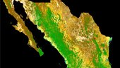
As part of a scientific collaboration with the Mexican Space Agency and other Mexican scientific public entities, ESA has combined images from the Copernicus Sentinel-2 mission to produce a detailed view of the different types of vegetation growing across the entire country.
odborný rada - inspektor Zeměměřického a katastrálního inspektorátu v Opavě v oboru služby 70. „Země
22.10.2018 9:30 ČÚZK - předpisy a opatření Zeměměřický a katastrální inspektorát v Opavěvypisuje výběrové řízení na místo
odborný rada - inspektor Zeměměřického a katastrálního inspektorátu v Opavě v oboru služby 70. „Zeměměřictví a katastr“
odborný rada - inspektor Zeměměřického a katastrálního inspektorátu v Opavě v oboru služby 70. „Země
22.10.2018 9:30 ČÚZK /Urady/Zememericke-a-katastralni-inspektoraty/Zememericke-a-katastralni-inspektoraty/Zememericky-a-katastralni-inspektorat-v-Opave/Uredni-deska/Oznameni-a-jina-uredni-sdeleni/Volna-mista/odborny-rada-inspektor-Zememerickeho-a-katastralodborný rada - inspektor Zeměměřického a katastrálního inspektorátu v Opavě v oboru služby 70. „Země
22.10.2018 9:30 ČÚZK - volná místa Zeměměřický a katastrální inspektorát v Opavě vypisuje výběrové řízení na místo odborný rada - inspektor Zeměměřického a katastrálního inspektorátu v Opavě v oboru služby 70. „ZeměAirbus to showcase smart solutions for safer oceans at Euronaval
22.10.2018 9:00 GISCafe.com Webcasts-Webinars Uniquely broad portfolio to provide basis for right decisions at the right timeParis, 18 October, 2018 – Airbus will be showcasing …
Utah Involves Public in Redistricting (ArcNews Online)
22.10.2018 9:00 GISCafe.com Webcasts-WebinarsMěnící se kráter nese jméno uznávaného planetárního vědce
22.10.2018 8:36 Český Kosmický PortálPovrch planety Mars se může jevit až nudně neměnný, nicméně přesto se mnoho útvarů na něm prochází neustálou proměnou. Dokládá to i tento snímek pořízený sondou Mars Express, který zachycuje dopadový kráter Greeley zasažený erozí.
Spectra Precision mění název
22.10.2018 8:10 Zeměměřič Výrobce geodetické techniky oznámil změnu názvuNejvětší klimatický hackathon v historii míří i do Brna (pozvánka)
22.10.2018 8:08 GISportal.cz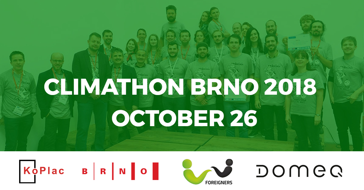
Z pátku na sobotu, 26.-27. října 2018, se v Brně koná 24hodinový hackathon s názvem #Climathon s cílem najít řešení na konkrétní problémy města spojené se životním prostředím a rozvojem města: snížení počtu aut v centru, vytipování přehřátých míst, doporučení pro výstavbu udržitelných budov či měření výskytu městské zeleně. Začátek je v pátek, 26. října 2018, v 18.00, […]
The post Největší klimatický hackathon v historii míří i do Brna (pozvánka) appeared first on GISportal.cz.
Společně otvíráme data
22.10.2018 4:10 Zeměměřič Na začátku září odstartoval šestý ročník soutěže Společně otevíráme data a možnost přihlásit se do soutěže se nám pomalu chýlí ke konci.Srdečně také zveme na vyhlášení soutěže Společně otevíráme data, které letos proběhne 27. 11. v Café Jedna.
V budově Nejvyššího kontrolního úřadu se v pátek a sobotu 14. a 15. září uskutečnil v pořadí již druhý Hackathon veřejné správy. Vývojářské týmy navrhly celkem 14 projektů založené na otevřených datech státních institucí. A kdo se stal vítězem?
Bentley Systems Announces Year in Infrastructure 2018 Awards Winners
21.10.2018 16:30 Bentley SystemsBentley Systems, Incorporated, the leading global provider of comprehensive software solutions for advancing the design, construction, and operations of infrastructure, has announced the winners of the Year in Infrastructure 2018 Awards. The annual awards program honors the extraordinary work of Bentley users advancing design, construction, and operations of infrastructure throughout the world.
Twelve independent jury panels of distinguished industry experts selected the 57 finalists from 420 nominations submitted by more than 340 user organizations around the world.
At a ceremony and gala at the conclusion of Bentley’s Year in Infrastructure 2018 Conference, Bentley acknowledged 19 Year in Infrastructure Awards winners and nine Special Recognition Awards winners.
Year in Infrastructure 2018 Special Recognition Awards winners:
Advancing Collaborative Digital Workflows in Rail and Transit
China Railway Engineering Consulting Group Co., Ltd. – BIM Project for the Beijing-Zhangjiakou High-speed Railway – Beijing, China
Advancing Digital Twins for Airports
Infraero Empresa Brasileira de Infraestrutura Aeroportuária – Digital Airport-Londrina – Paraná, Brazil
Advancing Digital Twins for Bridges
Composite Structures Lab, Chung-Ang University – Innovative Bridge Maintenance System Using Digital Twin Model – Seoul, South Korea
Advancing Digital Twins for Roads and Highways
Guangxi Communications Design Group Co., Ltd. – BIM-based Collaborative Design and Construction Management of All Elements and Objects in the Lipu-Yulin Expressway Project – Guangxi Zhuang Autonomous Region, China
Advancing Digital Twins for Tunnels
AECOM – Tideway Tunnels C410 Central Contract – London, United Kingdom
Advancing Digital Twins for Utilities Transmission and Distribution
POWERCHINA Hubei Electric Engineering Corporation Limited – Cha’anling-Xiaojiazhou
220-kV Electric Transmission Line Project – Xianning City, Hubei, China
Advancing Industrialization through Digital Components for Urban Infrastructure
CCCC Water Transportation Consultants Co., Ltd. – BIM Technology Application in the Municipal Infrastructure Phase 1 Project of Zhong-Guan-Cun Science and Technology Town – Baodi District, Tianjin City, China
Advancing Digital Workflows for Asset Performance Modeling of Transit Systems
Maharashtra Metro Rail Corporation Ltd. – Nagpur Metro Asset Information Management System – Nagpur, Maharashtra, India
Continuous Surveying in Constructioneering
Shell Chemical Appalachia LLC and Eye-bot Aerial Solutions – Pennsylvania Chemicals Project – Monaca, Pennsylvania, United States
The winners of Year in Infrastructure 2018 Awards for going digital advancements in infrastructure are:
Bridges
PT. WIJAYA KARYA (Persero) Tbk – Design and Build of Road Bridge at Teluk Lamong Port Project – Gresik-Surabaya, East Java, Indonesia
Buildings and Campuses
Shalom Baranes Associates – Cannon House Office Building Renewal – Washington, District of Columbia, United States
Communications Networks
iForte Solusi Infotek – iForte Fiber Management System – Jakarta, Indonesia
Construction
AAEngineering Group, LLP – Phase II of Pustynnoe Gold Plant: Modernization and Capacity Increase – Balkhash, Karaganda region, Kazakhstan
Digital Cities
Yunnan Yunling Engineering Cost Consultation Co., Ltd. – New Municipal Road Construction PPP Project of the Municipal Public Facility Construction Project of Guandu Culture New City – Kunming, Yunnan, China
Environmental Engineering
PT. WIJAYA KARYA (Persero) Tbk – Landslide Disaster Protection Project on the National Road Network – Cianjur, West Java, Indonesia
Manufacturing
Digital Engineering (BIM) Center of Shenyang Aluminum & Magnesium Engineering & Research Institute Co., Ltd. – Alumina Refinery Project Cooperated between CHALCO and Indonesia – Bukit Batu, West Kalimantan, Indonesia
Mining and Offshore Engineering
Northern Engineering & Technology Corporation, MCC – SINO Iron Ore Mine – Perth, Western Australia, Australia
Power Generation
Sacyr Somague – Hydroelectric Use of the Foz Tua Dam – Foz Tua, Alijó- Vila Real, Portugal
Project Delivery
AECOM – Gaining New Perspective through ProjectWise Project Insights – United Kingdom
Rail and Transit
Skanska Costain STRABAG Joint Venture (SCS) – HS2 Main Works Lots S1 and S2 – London, United Kingdom
Reality Modeling
Skand Pty Ltd – Building Envelope Inspection Powered by Machine Learning and Reality Modeling for RMIT University Brunswick Campus – Victoria, Australia
Road and Rail Asset Performance
CSX Transportation – Annual Patch Rail Capital Planning – Jacksonville, Florida, United States
Roads and Highways
Lebuhraya Borneo Utara – Pan Borneo Highway Sarawak – Sarawak, Malaysia
Structural Engineering
Shilp Consulting Engineers – Alambagh Bus Terminal – Lucknow, Uttar Pradesh, India
Utilities and Industrial Asset Performance
Oman Gas Company S.A.O.C. – Asset Performance Solution for Reliability Management – Al-Khuwair, Muscat, Oman
Utilities Transmission and Distribution
Pestech International Berhad – Substation Design & Automation for Olak Lempit Substation Project – Banting, Selangor, Malaysia
Water and Wastewater Treatment Plants
MCC Capital Engineering & Research Incorporation Limited – 400,000 ton/day Water Supply Project of Wenjiang District, Chengdu City – Chengdu, Sichuan, China
Water, Wastewater, and Stormwater Networks
DTK Hydronet Solutions – Conceptioneering and Master Planning of Bankura Multi Village Bulk Water Supply Scheme – Bankura, West Bengal, India
Bentley Systems has posted highlights of this year’s winning projects on its website. Detailed descriptions of all nominated projects are in the print and digital versions of its 2018 Infrastructure Yearbook, which will be published in early 2019. To review the past editions of this publication, which together feature more than 3,500 world-class projects recognized in the Year in Infrastructure Awards program since 2004, access Bentley’s Infrastructure Yearbooks.
Image and caption:
Winners of Bentley Systems Year in Infrastructure 2018 Awards
About the Year in Infrastructure Conference and Awards Program
Since 2004, the Year in Infrastructure Awards program has showcased excellence and innovation in the design, construction, and operations of infrastructure projects around the world. The awards program is the only competition of its kind that is global in scope and comprehensive in categories covered, encompassing all types of infrastructure projects. The awards program is open to all users of Bentley software. Independent panels of industry experts select finalists for each category. Learn more.
Bentley’s Year in Infrastructure Conference features a series of presentations and interactive workshops exploring the intersection of technology and business drivers, and how they are shaping the future of infrastructure project delivery and asset performance.
USGIF Announces 2018 GEOINT Community Week Events
21.10.2018 10:34 GISCafe.com Webcasts-Webinars Foundation to host a variety of opportunities for learning, discussion, and networkingHerndon, Virginia (October 18, 2018)—The United States …
Orbit Logic’s Scheduling Software Selected for NASA Satellite Servicing Technology Demonstration Mission
21.10.2018 10:26 GISCafe.com Webcasts-Webinars GREENBELT, MD (October 18, 2018) – Orbit Logic announced today that NASA has selected Orbit Logic’s STK Scheduler software for the …"Digital Evolution Moves On at Bentley Year in Infrastructure 2019 in London" by Susan Smith
21.10.2018 10:16 GISCafe.com Webcasts-WebinarsDigitalisation gets everyone talking at INTERGEO 2018
21.10.2018 10:14 GISCafe.com Webcasts-Webinars Frankfurt/Karlsruhe, 18 October 2018 | A highly successful INTERGEO 2018 drew to a close today in Frankfurt. The trade fair and conference reinforced …Sledujte živě start sondy BepiColombo
19.10.2018 17:13 Český Kosmický PortálSledujte živě start společné mise ESA a JAXA BepiColombo k planetě Merkur. Do vesmíru se vydá na palubě rakety Ariane 5 z evropského kosmodromu (stát Francouzská Guayana).
20181019 - Vzorová data VF ISKN ve verzi 5.3
19.10.2018 15:01 ČÚZK - Výměnný formát ISKN Rozšíření vzorových dat VF ISKN ve verzi 5.3.Stavová data – datové skupiny 1-12, tj. SPI s jinými právními vztahy a data SGI
Změnová data – datové skupiny 1-6, tj. SPI s jinými právními vztahy
- Data za období 01.01.2018 – 01.02.2018
- Data za období 01.02.2018 – 01.03.2018
- Data za období 01.03.2018 – 01.04.2018
Všechny oprávněné subjekty z k.ú. Jáma včetně osobních údajů.
20181019 - Vzorová data VF ISKN ve verzi 5.3
19.10.2018 15:01 ČÚZK - Výměnný formát ISKN Rozšíření vzorových dat VF ISKN ve verzi 5.3.Stavová data – datové skupiny 1-12, tj. SPI s jinými právními vztahy a data SGI
Změnová data – datové skupiny 1-6, tj. SPI s jinými právními vztahy
Data za období 01.01.2018 – 01.02.2018 ve formátu ZIP
'Landing with EGNOS’ exhibition opens in Toulouse
19.10.2018 14:49 European GNSS Agency
The European Geostationary Navigation Overlay Service (EGNOS), Europe's regional satellite-based augmentation system (SBAS), provides safety of life navigation services to aviation, maritime and land-based users over most of Europe. The ‘Landing with EGNOS’ exhibition, which opened at the Cité de l’Espace in Toulouse on 11 October, explains the system’s various applications, particularly for the aviation sector.
Speaking at a roundtable discussion held at the exhibition’s official launch, Jean-Marc Pieplu, EGNOS Programme Manager at the European GNSS Agency (GSA), said that the exhibition recognised the work that had been conducted over the past 20 years to put the EGNOS system into operation.
“We should be proud of the success of EGNOS, not just for us but because users are taking on board this European technology,” he said, adding that the exhibition was important, as the time had come to explain to the general public about what EGNOS is, and how it is widely used in Europe to contribute to aviation safety.

The opening ceremony was attended by about 100 students from France’s National Civil Aviation University
A350 EGNOS simulator
Visitors to the exhibition will have the opportunity to simulate landing a plane in an A350 EGNOS simulator. Thierry Racaud, CEO of European Satellite Services Provider (ESSP), which is in charge of EGNOS operations and service provision, said that ESSP was delighted that Cité de l’Espace had installed the A350 EGNOS simulator in its permanent exhibition.
“This simulator is a great way for the general public to understand the benefits of the European Union’s space programmes, and of EGNOS in particular, in their daily lives,” he said, adding that it was a source of pride for the EGNOS community to see the latest commercial aircraft adopting this technology.

Visitors to the exhibition can try landing a plane in an A350 EGNOS simulator
Our clients like EGNOS
Representing manufacturers of commercial aircraft at the roundtable, Thierry Harquin, an engineer and EGNOS expert at Airbus, said that Airbus likes EGNOS very much because its clients like EGNOS. He said that at Airbus there is a programme to have all models of A319/A320/A321 and A330 with optional SBAS/GBAS. This is optional because some countries, such as Australia for instance, are not covered by SBAS. “Our first client for the A320 with the SBAS option is EasyJet,” he said.
Nicolas Dubois, Executive Deputy Director at DGAC/DTI, the technical department of DSNA Services (Direction des services de la navigation aérienne), the French organisation in charge of air traffic control, highlighted France’s role as an early adopter of EGNOS. “France was the first country to publish an EGNOS approach procedure and was the first to implement an LPV-200 approach,” he said, adding that DSNA would be decommissioning around 50 ILS in the coming year thanks to the use of EGNOS and will then ensure that more than 100 runways have CAT 1 ILS BY 2020.
The opening ceremony was attended by about 100 students from France’s National Civil Aviation University and from various schools and colleges in Toulouse, who were welcomed with a number of flash presentations on the European Union’s satellite navigation programmes.
'Landing with EGNOS’ exhibition opens in Toulouse
19.10.2018 14:49 European GNSS AgencyThe European Geostationary Navigation Overlay Service (EGNOS), Europe's regional satellite-based augmentation system (SBAS), provides safety of life navigation services to aviation, maritime and land-based users over most of Europe. The ‘Landing with EGNOS’ exhibition, which opened at the Cité de l’Espace in Toulouse on 11 October, explains the system’s various applications, particularly for the aviation sector.
Speaking at a roundtable discussion held at the exhibition’s official launch, Jean-Marc Pieplu, EGNOS Programme Manager at the European GNSS Agency (GSA), said that the exhibition recognised the work that had been conducted over the past 20 years to put the EGNOS system into operation.
“We should be proud of the success of EGNOS, not just for us but because users are taking on board this European technology,” he said, adding that the exhibition was important, as the time had come to explain to the general public about what EGNOS is, and how it is widely used in Europe to contribute to aviation safety.
A350 EGNOS simulator
Visitors to the exhibition will have the opportunity to simulate landing a plane in an A350 EGNOS simulator. Thierry Racaud, CEO of European Satellite Services Provider (ESSP), which is in charge of EGNOS operations and service provision, said that ESSP was delighted that Cité de l’Espace had installed the A350 EGNOS simulator in its permanent exhibition.
“This simulator is a great way for the general public to understand the benefits of the European Union’s space programmes, and of EGNOS in particular, in their daily lives,” he said, adding that it was a source of pride for the EGNOS community to see the latest commercial aircraft adopting this technology.
Our clients like EGNOS
Representing manufacturers of commercial aircraft at the roundtable, Thierry Harquin, an engineer and EGNOS expert at Airbus, said that Airbus likes EGNOS very much because its clients like EGNOS. He said that at Airbus there is a programme to have all models of A319/A320/A321 and A330 with optional SBAS/GBAS. This is optional because some countries, such as Australia for instance, are not covered by SBAS. “Our first client for the A320 with the SBAS option is EasyJet,” he said.
Nicolas Dubois, Executive Deputy Director at DGAC/DTI, the technical department of DSNA Services (Direction des services de la navigation aérienne), the French organisation in charge of air traffic control, highlighted France’s role as an early adopter of EGNOS. “France was the first country to publish an EGNOS approach procedure and was the first to implement an LPV-200 approach,” he said, adding that DSNA would be decommissioning around 50 ILS in the coming year thanks to the use of EGNOS and will then ensure that more than 100 runways have CAT 1 ILS BY 2020.
The opening ceremony was attended by about 100 students from France’s National Civil Aviation University and from various schools and colleges in Toulouse, who were welcomed with a number of flash presentations on the European Union’s satellite navigation programmes.
'Landing with EGNOS’ exhibition opens in Toulouse
19.10.2018 14:49 European GNSS AgencyThe European Geostationary Navigation Overlay Service (EGNOS), Europe's regional satellite-based augmentation system (SBAS), provides safety of life navigation services to aviation, maritime and land-based users over most of Europe. The ‘Landing with EGNOS’ exhibition, which opened at the Cité de l’Espace in Toulouse on 11 October, explains the system’s various applications, particularly for the aviation sector.
Speaking at a roundtable discussion held at the exhibition’s official launch, Jean-Marc Pieplu, EGNOS Programme Manager at the European GNSS Agency (GSA), said that the exhibition recognised the work that had been conducted over the past 20 years to put the EGNOS system into operation.
“We should be proud of the success of EGNOS, not just for us but because users are taking on board this European technology,” he said, adding that the exhibition was important, as the time had come to explain to the general public about what EGNOS is, and how it is widely used in Europe to contribute to aviation safety.
The opening ceremony was attended by about 100 students from France’s National Civil Aviation University
A350 EGNOS simulator
Visitors to the exhibition will have the opportunity to simulate landing a plane in an A350 EGNOS simulator. Thierry Racaud, CEO of European Satellite Services Provider (ESSP), which is in charge of EGNOS operations and service provision, said that ESSP was delighted that Cité de l’Espace had installed the A350 EGNOS simulator in its permanent exhibition.
“This simulator is a great way for the general public to understand the benefits of the European Union’s space programmes, and of EGNOS in particular, in their daily lives,” he said, adding that it was a source of pride for the EGNOS community to see the latest commercial aircraft adopting this technology.
Visitors to the exhibition can try landing a plane in an A350 EGNOS simulator
Our clients like EGNOS
Representing manufacturers of commercial aircraft at the roundtable, Thierry Harquin, an engineer and EGNOS expert at Airbus, said that Airbus likes EGNOS very much because its clients like EGNOS. He said that at Airbus there is a programme to have all models of A319/A320/A321 and A330 with optional SBAS/GBAS. This is optional because some countries, such as Australia for instance, are not covered by SBAS. “Our first client for the A320 with the SBAS option is EasyJet,” he said.
Nicolas Dubois, Executive Deputy Director at DGAC/DTI, the technical department of DSNA Services (Direction des services de la navigation aérienne), the French organisation in charge of air traffic control, highlighted France’s role as an early adopter of EGNOS. “France was the first country to publish an EGNOS approach procedure and was the first to implement an LPV-200 approach,” he said, adding that DSNA would be decommissioning around 50 ILS in the coming year thanks to the use of EGNOS and will then ensure that more than 100 runways have CAT 1 ILS BY 2020.
The opening ceremony was attended by about 100 students from France’s National Civil Aviation University and from various schools and colleges in Toulouse, who were welcomed with a number of flash presentations on the European Union’s satellite navigation programmes.
odborný referent – zápisy v řízení V a Z, řízení o SP
19.10.2018 12:25 ČÚZK - předpisy a opatření Katastrální úřad pro Olomoucký kraj - Katastrální pracoviště Hranicevypisuje výběrové řízení na místo
odborný referent – zápisy v řízení V a Z, řízení o SP
odborný referent – zápisy v řízení V a Z, řízení o SP
19.10.2018 12:25 ČÚZK /Urady/Katastralni-urady/Katastralni-urady/Katastralni-urad-pro-Olomoucky-kraj/Uredni-deska/Oznameni-a-jina-uredni-sdeleni/Volna-mista/odborny-referent-–-zapisy-v-rizeni-V-a-Z,-rizeni-oodborný referent – zápisy v řízení V a Z, řízení o SP
19.10.2018 12:25 ČÚZK - volná místa Katastrální úřad pro Olomoucký kraj - Katastrální pracoviště Hranice vypisuje výběrové řízení na místo odborný referent – zápisy v řízení V a Z, řízení o SPLake Disappointment
19.10.2018 10:05 ESA Observing the Earth
Earth observation image of the week: Copernicus Sentinel-2 takes us over Lake Disappointment in northwest Australia
Earth from Space
19.10.2018 10:05 ESA Observing the Earth
In this edition, discover one of the most remote areas of Australia with Copernicus Sentinel-2
uzavření kp pv 25.10.2018
19.10.2018 8:23 ČÚZK /Urady/Katastralni-urady/Katastralni-urady/Katastralni-urad-pro-Olomoucky-kraj/Katastralni-pracoviste/KP-Prostejov/O-uradu/Aktuality/uzavreni-kp-pv-25-10-2018uzavření kp pv 25.10.2018
19.10.2018 8:23 ČÚZK - předpisy a opatření Katastrální úřad pro Olomoucký kraj - Katastrální pracoviště Prostějov zveřejnil novou aktualitu: OZNÁMENÍ. Ve čtvrtek 25. října 2018 bude katastrální pracoviště z důvodu přerušení dodávky elektřiny provozovatelem distribuční soustavy společností E.ON Distribuce, a.s. UZAVŘENO.Děkujeme za pochopení.
Shell Chemicals Project in Pennsylvania Wins Special Recognition Award for Continuous Surveying in Constructioneering
19.10.2018 2:00 Bentley SystemsShell Chemical Appalachia LLC and Eye-bot Aerial Solutions were recognized by Bentley Systems with the Special Recognition Award for Continuous Surveying in Constructioneering at Bentley’s Year in Infrastructure Conference, held in London this week.
Shell Chemical Appalachia is constructing a multi-billion dollar, world-scale ethane cracking plant to create polyethylene in the western Pennsylvania region. To help monitor and manage construction of the facility, the organization used unmanned aerial vehicles to capture real-time, accurate data of the entire site and the surrounding areas, close to 450 acres total, and processed the data into a high-resolution orthophoto and 3D reality mesh model. The 3D data provided a strategic perspective of the existing site conditions and served as a single source of truth for both future and retrospective progress analysis, optimizing collaboration and decision making between the client and the EPC contractors, with over 500 multidiscipline end users across 10 companies.
On a weekly basis, the project team captured more than 8,000 images and processed the images as 2D and 3D deliverables within the required 72-hour window using Bentley’s ContextCapture software. The high-speed processing engines of ContextCapture produced a dimensionally accurate 3D reality mesh, enabling the identification and resolution of potential construction problems before they impact operations on site. The 3D reality mesh models are expected to facilitate inventory control and improve emergency response management.
Phil Christensen, senior vice president, reality modeling for Bentley Systems, said, “It is our pleasure to present Shell Chemical Appalachia and Eye-bot Aerial Solutions with a Special Recognition award for the pioneering work they are doing in constructioneering. Using drone imagery and our ContextCapture, the team continuously surveys and creates 3D reality meshes of the entire construction site, supporting weekly inspections and monitoring of construction progress. To do this for the entire site on a regular schedule, the team leverages Bentley’s cloud services, and we are working together to further streamline automated work flows and improve processing time.”
Dmitry Gurevich, Shell’s Information Technology Manager, said, “Constructing the plant of the future means embracing digitalisation. In construction, Digital is about advancing the technology that helps us staying on top of progress and assure quality, while keeping people safe. In that respect, the 3D reality mesh modelling technology has made a profound impact on ways of working on the Project, rendering benefits above and beyond of what we had imagined when starting the modelling program 18 months ago.”
Nastavenie merania so systémami Galileo a BeiDou
18.10.2018 19:09 Geotronics.skPríspevok Nastavenie merania so systémami Galileo a BeiDou zobrazený najskôr Geotronics Slovakia.
20181018 Vrchní referent/rada oddělení právních vztahů k nemovitostem
18.10.2018 14:06 ČÚZK /Urady/Katastralni-urady/Katastralni-urady/Katastralni-urad-pro-Stredocesky-kraj/Katastralni-pracoviste/KP-Slany/O-uradu/Aktuality/20161013Rada-odborny-rada-–-informatik-(1)20181018 Vrchní referent/rada oddělení právních vztahů k nemovitostem
18.10.2018 14:06 ČÚZK - předpisy a opatření Katastrální úřad pro Středočeský kraj - Katastrální pracoviště Slaný Vyhlášení výběrového řízení: Vrchní referent/rada oddělení právních vztahů k nemovitostem V části "Úřední deska", v sekci "Oznámení a jiná úřední sdělení" bylo vystaveno "Oznámení o vyhlášení výběrového řízení na obsazení služebního místa Vrchní referent/rada oddělení právních vztahů k nemovitostem"Vrchní referent/rada oddělení právních vztahů k nemovitostem
18.10.2018 14:02 ČÚZK - volná místa Katastrální úřad pro Středočeský kraj - Katastrální pracoviště Slaný vypisuje výběrové řízení na místo Vrchní referent/rada oddělení právních vztahů k nemovitostemVrchní referent/rada oddělení právních vztahů k nemovitostem
18.10.2018 14:02 ČÚZK /Urady/Katastralni-urady/Katastralni-urady/Katastralni-urad-pro-Stredocesky-kraj/Uredni-deska/Oznameni-a-jina-uredni-sdeleni/Volna-mista/Vrchni-referent-rada-oddeleni-pravnich-vztahu-(1)Vrchní referent/rada oddělení právních vztahů k nemovitostem
18.10.2018 14:02 ČÚZK - předpisy a opatření Katastrální úřad pro Středočeský kraj - Katastrální pracoviště Slanývypisuje výběrové řízení na místo Vrchní referent/rada oddělení právních vztahů k nemovitostem
Vrchní referent/rada oddělení právních vztahů k nemovitostem
20181018 Rada/odborný rada oddělení podpory ICT – informatik
18.10.2018 13:34 ČÚZK /Urady/Katastralni-urady/Katastralni-urady/Katastralni-urad-pro-Stredocesky-kraj/O-uradu/Aktuality/20180709-Odborny-referent-oddeleni-dokumentace-(1)20181018 Rada/odborný rada oddělení podpory ICT – informatik
18.10.2018 13:34 ČÚZK - předpisy a opatření Katastrální úřad pro Středočeský kraj zveřejnil novou aktualitu: Rada/odborný rada oddělení podpory ICT – informatik V části "Úřední deska", v sekci "Oznámení a jiná úřední sdělení" bylo vystaveno "Oznámení o vyhlášení výběrového řízení na obsazení služebního místa Rada/odborný rada oddělení podpory ICT – informatik Katastrálního úřadu pro Středočeský kraj"Rada/odborný rada oddělení podpory ICT – informatik
18.10.2018 13:33 ČÚZK /Urady/Katastralni-urady/Katastralni-urady/Katastralni-urad-pro-Stredocesky-kraj/Uredni-deska/Oznameni-a-jina-uredni-sdeleni/Volna-mista/Rada-odborny-rada-oddeleni-podpory-ICT-–-informatiRada/odborný rada oddělení podpory ICT – informatik
18.10.2018 13:33 ČÚZK - předpisy a opatření Katastrální úřad pro Středočeský kraj - technická sekcevypisuje výběrové řízení na místo Rada/odborný rada oddělení podpory ICT – informatik
Rada/odborný rada oddělení podpory ICT – informatik
Rada/odborný rada oddělení podpory ICT – informatik
18.10.2018 13:33 ČÚZK - volná místa Katastrální úřad pro Středočeský kraj - technická sekce vypisuje výběrové řízení na místo Rada/odborný rada oddělení podpory ICT – informatikMáme nově k dispozici laserový skener Riegl miniVUX-1 pro UAV
18.10.2018 12:39 UpVision Kromě hyperspektrální kamery máme nově k dispozici laserový skener Riegl miniVUX-1 pro UAV. Začínáme provádět první testy a výstupy vypadají velice slibně, což jsme čekali, jelikož Riegl je světovou jedničkou v laserových skenerech pro UAV.Fotky zde:
https://plus.google.com/u/0/b/115833877689730865211/+UpvisionCz1/posts/H9kmbpbTiu8
Stopy nedávné tektoniky na Marsu
18.10.2018 11:21 Český Kosmický PortálNa snímku zachycené výrazné příkopy byly zformovány tlakem na povrch planety před méně než deseti milióny let.
Přihlaste se na školení - ušetří Vám v budoucnu spoustu času [Knihovna geografie, byTopic]
18.10.2018 11:10 Katedra aplikované geoinformatiky a kartografie Přf UK Užitečné školení v Knihovně geografieHexagon’s Geospatial Division Releases M.App Enterprise 2018
18.10.2018 11:06 GISCafe.com Webcasts-Webinars NORCROSS, GA., October 15, 2018 – Hexagon’s Geospatial division announces a new version of M.App Enterprise for 2018, M.App Enterprise …URISA Leaders Recognized at GIS-Pro & CalGIS 2018
18.10.2018 10:29 GISCafe.com Webcasts-Webinars Des Plaines, IL (October 17, 2018) -- More than 500 GIS professionals - from 43 states, 5 Canadian provinces, and 8 countries - …Contract signing to boost performance and security of Galileo services
18.10.2018 9:15 ESA Navigation
Europe’s 26 navigation satellites in orbit are providing Galileo Initial Services – available to users around the globe since 2016 – and a new ESA contract signing means these services will be delivered on a more accurate basis and more securely than ever.
20181018 - Vyhlášení výsledků voleb
18.10.2018 9:12 ČÚZK /Uvod/Produkty-a-sluzby/RUIAN/RUIAN-novinky/2018/20181018-Vyhlaseni-vysledku-voleb20181018 - Vyhlášení výsledků voleb
18.10.2018 9:12 ČÚZK - předpisy a opatření Dne 9. 10. 2018 a 16. 10. 2018 byly vyhlášeny a uveřejněny ve Sbírce zákonů č. 225/2018 Sb. a č. 231/2018 Sb. celkové výsledky voleb do zastupitelstev obcí a do Senátu Parlamentu ČR. Státní volební komisí byly odemčeny volební okrsky v RÚIAN a nyní je možné měnit jejich vymezení.A New Way to Visualize Microsoft SharePoint Data (ArcNews Online)
18.10.2018 9:00 GISCafe.com Webcasts-WebinarsKonference Mapování | GIS | Rozvoj vol. 5 (pozvánka)
18.10.2018 8:48 GISportal.cz
Katedra rozvojových a environmentálních studií UP Olomouc zve na pátý ročník konference Mapování | GIS | Rozvoj, která láká do Olomouce zájemce nejen o rozvojové země, ale také o možnosti využití geografických informačních systémů (GIS) a mapování v těchto oblastech. Letošní ročník se bude konat: Kdy: pátek 9. 11. 2016, od 9.30 (registrace bude probíhat od 8.30 do 9.30). […]
The post Konference Mapování | GIS | Rozvoj vol. 5 (pozvánka) appeared first on GISportal.cz.
Konference Mapování | GIS | Rozvoj vol. 5 (pozvánka)
18.10.2018 8:48 GISportal.czKatedra rozvojových a environmentálních studií UP Olomouc zve na pátý ročník konference Mapování | GIS | Rozvoj, která láká do Olomouce zájemce nejen o rozvojové země, ale také o možnosti využití geografických informačních systémů (GIS) a mapování v těchto oblastech. Letošní ročník se bude konat: Kdy: pátek 9. 11. 2018, od 9.30 (registrace bude probíhat od 8.30 do 9.30). […]
The post Konference Mapování | GIS | Rozvoj vol. 5 (pozvánka) appeared first on GISportal.cz.
Přerušení provozu Sbírky listin v DP ve čtvrtek 25.10.2018 a v pátek 26.10.2018.
18.10.2018 8:24 ČÚZK - předpisy a opatřeníVážení uživatelé, oznamujeme, že z provozních důvodů bude ve čtvrtek 25.10.2018 od 16:30 do cca 22:00 a v pátek 26.10.2018 od 14:30 do cca 22:00 kompletní odstávka poskytování dokumentů ze Sbírky listin.
Dne 25.10.2018 v době od 16:30 do cca 17:30 bude z provozních důvodů zcela přerušen provoz Dálkového přístupu i Webových služeb dálkového přístupu.
Za komplikace tímto způsobené se omlouváme a děkujeme za pochopení.
Přerušení provozu Sbírky listin v DP ve čtvrtek 25.10.2018 a v pátek 26.10.2018.
18.10.2018 8:24 Dálkový přístup k údajům KN ČR Vážení uživatelé, oznamujeme, že z provozních důvodů bude ve čtvrtek 25.10.2018 od 16:30 do cca 22:00 a v pátek 26.10.2018 od 14:30 do cca 22:00 kompletní odstávka poskytování dokumentů ze Sbírky listin.Dne 25.10.2018 v době od 16:30 do cca 17:30 bude z provozních důvodů zcela přerušen provoz Dálkového přístupu i Webových služeb dálkového přístupu.
Za komplikace tímto způsobené se omlouváme a děkujeme za pochopení.
Přerušení provozu Sbírky listin v DP ve čtvrtek 25.10.2018 a v pátek 26.10.2018.
18.10.2018 8:24 ČÚZK - předpisy a opatřeníVážení uživatelé, oznamujeme, že z provozních důvodů bude ve čtvrtek 25.10.2018 od 16:30 do cca 22:00 a v pátek 26.10.2018 od 14:30 do cca 22:00 kompletní odstávka poskytování dokumentů ze Sbírky listin. Za komplikace tímto způsobené se omlouváme a děkujeme za pochopení.
Přerušení provozu Sbírky listin v DP ve čtvrtek 25.10.2018 a v pátek 26.10.2018.
18.10.2018 8:24 Dálkový přístup k údajům KN ČR Vážení uživatelé, oznamujeme, že z provozních důvodů bude ve čtvrtek 25.10.2018 od 16:30 do cca 22:00 a v pátek 26.10.2018 od 14:30 do cca 22:00 kompletní odstávka poskytování dokumentů ze Sbírky listin. Za komplikace tímto způsobené se omlouváme a děkujeme za pochopení.Přerušení provozu Sbírky listin v DP ve čtvrtek 25.10.2018 a v pátek 26.10.2018.
18.10.2018 8:24 ČÚZK /Aplikace-DP-do-KN/Aplikace-DP-do-KN/Archiv-DP/235773New Open Applications Advance Comprehensive Modeling Environment for Multidiscipline Collaboration
18.10.2018 2:00 Bentley SystemsOpenSite Designer, OpenBuildings Designer, OpenBridge Designer, and OpenFlows FLOOD further extend Bentley’s design engineering and analysis portfolio
LONDON, U.K. – The Year in Infrastructure 2018 Conference – 18 October 2018 –
Bentley Systems, Incorporated, the leading global provider of comprehensive software solutions for advancing the design, construction, and operations of infrastructure, today launched OpenSite Designer, a built-for-purpose application for the design and construction of civil site projects. It also launched OpenBuildings, bringing together its AECOsim building design and Speedikon factory and industrial design applications; and announced the availability of OpenBuildings Station Designer, a specialized application for designing rail and metro stations. At the same time, Bentley announced the availability of OpenBridge Designer, which combines Bentley’s bridge modeling, analysis and design capabilities into one comprehensive package, and OpenFlows FLOOD, a flood analysis and early warning system.
In addition, in pursuit of its ‘industrialization’ strategy, Bentley announced it has rebranded under its Open portfolio several of its applications based on MicroStation technology which collectively accelerate the advancement of its comprehensive modeling environment by connecting digital workflows across disciplines and sharing digital components in its Connected Data Environment (CDE).
Bhupinder Singh, chief product officer, Bentley Systems, said, “Open has three meanings. First, it signifies open to multiple disciplines. Second, it means open to analysis and simulation. Using different applications, two different disciplines, for example, a geotechnical engineer and a structural engineer, can iterate on the same dataset in our comprehensive modeling environment, providing a ‘digital feedback loop’ and enhancing their collaboration across BIM workflows. And third, because MicroStation technology underpins Open applications, users can produce multidiscipline deliverables and accomplish multidiscipline clash resolution from any Open application. Bentley’s comprehensive modeling environment is ‘Open’ for collaborative digital workflows.”
Fully 49 of the 62 finalists and awardees of this year’s Year in Infrastructure Awards credited collaborative digital workflows in their successful outcomes. For example, OpenRoads, Bentley’s civil design applications for road networks, is credited by 22 awards finalists’ projects in 12 categories, and OpenPlant, Bentley’s plant design project management applications, is credited by 10 finalists’ projects in 9 different categories. ProjectWise and/or AssetWise were credited by finalists’ projects in 16 of 19 awards categories this year.
OpenSite Designer
The collaborative nature of digital workflows connecting analysis and simulation with design and modeling is exemplified in OpenSite, Bentley’s new solution for the design and construction of civil site projects. OpenSite provides rapid site modeling and analysis, earthwork optimization and quantification, drainage and underground utilities, and automated project deliverables.
OpenSite Designer provides the most comprehensive site design workflow available including reality modeling, geotechnical, underground utilities, stormwater drainage, terrain modeling, detailed drawing production, and visualization. OpenSite Designer optimizes design outcomes with multidiscipline information modeling and analysis. Interoperating with PLAXIS, Bentley’s newly acquired geotechnical engineering solution, site plans can be enhanced with new information about the active properties of soil including bearing capacity, stresses, and displacement.
OpenBuildings Designer
The newly launched OpenBuildings Designer incorporates all of the capabilities of AECOsim Building Designer as well as Components Center and a range of new capabilities and standards including EnergyPlus, a building energy model to help users comply with ASHRAE standards in the US, and UK energy requirements; support of international standards including IFC 2x3, IFC4 Reference View, COBie, and Singapore’s Building and Construction Authority; new capabilities to design curtain wall systems; and OpenBuildings Speedikon, a leading application for industrialized design and construction. OpenBuildings Designer takes advantage of collaborative digital workflows with other applications in Bentley’s Open portfolio, for example templates in OpenBuildings Station Designer for tunnel segments created through GenerativeComponents based on linear alignment from OpenRail. Showcasing their robustness and versatility, OpenBuildings applications were credited by 32 of 62 of the Year in Infrastructure Awards finalists projects in 15 of 19 categories.
OpenBridge Designer
OpenBridge Designer is a new, all-encompassing application that integrates the modeling capabilities of OpenBridge Modeler and the analysis and design features of RM Bridge, LEAP Bridge Concrete, and LEAP Bridge Steel to meet the design and construction needs of both concrete and steel bridges. OpenBridge Designer enables bridge designers to rapidly create an intelligent, parametric bridge model, fully integrated with analysis and design, as well as drawings. It enables seamless synchronization of various disciplines for analysis, design, detailing, documentation, construction engineering and load-rating.
OpenFlows FLOOD
Bentley also announced the rebranding of its Haestad water modeling and ACTION Modulers flood analysis product lines to form OpenFlows for water districts, sewer utilities and flood plain managers. OpenFlows extends smart water networks capabilities with GIS-based asset-centric information for water loss reduction, water operations, flood prediction and prevention. OpenFlows FLOOD continuously monitors watersheds, integrating data from real-time monitoring stations and numerical models to calculate risk levels. OpenFlows FLOOD mitigates flood risk, improving understanding of the processes involved in flood generation, and transmitting early alerts to reduce the impact caused by floods.
Connecting Digital Workflows Across Disciplines
Applications for analysis and simulation, on the one hand, can collaboratively and iteratively work with applications for design and modeling, and on the other, connect operational workflows and converge the work of different disciplines. Collaborative digital workflows are characterized by data captured or created for one purpose being accessed and used by other applications for other purposes thereby saving time, minimizing rework, and improving data quality over the asset lifecycle.
An example of multidiscipline collaboration with OpenFlows involves workflows that use ContextCapture to create a 3D reality mesh, feeding into OpenFlows FLOOD modeling and using the terrain as input to various analyses in a single review environment for visualization and presentation to stakeholders using LumenRT.
Connecting analysis with modeling in another Open collaborative digital workflow involves the layout of road geometry, and hydraulic analysis and design using storm analysis tools including the determination of the size of storm inlets, pipes, depth of pipes, and manholes. The collaborative nature of the workflow enables clash detection in the subsurface environment, and iteration and adjustment as needed, to confirm functional and physical characteristics.
Other instances of Open collaborative digital workflows connecting design and analysis include OpenUtilities with Siemens’ PSS©SINCAL, which helps utilities improve resilience and deal with weak spots in the grid; and OpenBuildings Station Designer with LEGION pedestrian simulation, to enable designers to design, test, and validate simulations of scenarios for pedestrian traffic.
Rebranding
Completing its announcement about Open applications, Bentley said that Bentley Map will be rebranded as OpenCities Map; and OpenComms, aimed primarily at multisystem operators, will incorporate Bentley Fiber and Bentley Coax.
About Bentley Systems
Bentley Systems is the leading global provider of software solutions to engineers, architects, geospatial professionals, constructors, and owner-operators for the design, construction, and operations of infrastructure. Bentley’s MicroStation-based engineering and BIM applications, and its digital twin cloud services, advance the project delivery (ProjectWise) and the asset performance (AssetWise) of transportation and other public works, utilities, industrial and resources plants, and commercial and institutional facilities.
Bentley Systems employs more than 3,500 colleagues, generates annual revenues of $700 million in 170 countries, and has invested more than $1 billion in research, development, and acquisitions since 2012. From inception in 1984, the company has remained majority-owned by its five founding Bentley brothers. Bentley shares transact by invitation on the NASDAQ Private Market; strategic partner Siemens AG has accumulated a non-voting minority stake.
# # #
Bentley, the Bentley logo, AECOsim Building Designer, AssetWise, ContextCapture, LEGION, LumenRT, MicroStation, OpenBridge, OpenBuildings, OpenCities, OpenCities Map, OpenComms, OpenFlows, OpenRoads, OpenUtilities, and ProjectWise are either registered or unregistered trademarks or service marks of Bentley Systems, Incorporated or one of its direct or indirect wholly owned subsidiaries. All other brands and product names are trademarks of their respective owners.
INSPIRE téma Rozšířené Parcely (CPX)
18.10.2018 2:00 Cenia - Katalog metadat ČR - INSPIRE Rozšíření má za cíl poskytovat katastrální mapu s obsahem podle vyhlášky ve vektorové podobě ve struktuře plně v souladu se strukturou danou směrnicí INSPIRE. Data rozšiřují směrnici INSPIRE pro téma katastrální parcely (CP) o věcná břemena, geodetické body, další prvky mapy, původní obloukovou geometrii a o parcely určené definičním bodem (ty pouze v oblastech s analogovou mapou). Vychází z katastrální mapy, která je závazným státním mapovým dílem velkého měřítka, obsahuje body polohového bodového pole, polohopis a popis a může mít formu digitální mapy, analogové mapy nebo digitalizované mapy. Publikovaná data obsahují katastrální území pro celou Českou Republiku, parcely a jejich hranice, věcná břemena, další prvky mapy a původní obloukovou geometrii z území, kde je digitální mapa (k 26. 11. 2018 je to 96,16% území České republiky, t.j. 75 840,00km2) a ve zbytku území katastrální parcely určené pouze definičním bodem (tedy bez hranic a polygonu). Katastrální parcely a hranice obsahují oproti datové sadě INSPIRE některé atributy navíc. Jedná se o typ hranice, způsob využití území, druh pozemku, vazbu na budovu a o mapové značky. Více katastrální zákon 344/1992 SB., katastrální vyhláška č.26/2007 Sb. v platném znění a INSPIRE Data Specification on Cadastral Parcels v 3.0.1. Data ve formátu GML 3.2.1 jsou validní proti schématu XML pro Rozšířené Parcely (CPX) ve verzi 4.0.Copernicus for Agriculture: Training and Information Session
17.10.2018 17:26 GISCafe.com Webcasts-Webinars Copernicus for Agriculture is a Training and Information Session on Copernicus to be held in Bari, Italy, next November 27, 2018.The meeting is …
New Lockheed Martin-Built Protected Communications Satellite Confirmed Online in Orbit Following Successful Launch
17.10.2018 17:25 GISCafe.com Webcasts-Webinars Fourth Satellite Will Complete Global Coverage for Advanced Extremely High Frequency ConstellationCAPE CANAVERAL AIR FORCE STATION, Fla., Oct. 17, …
New Power Pack For Rugo™ Drone Light Meets FAA Night UAV Requirements
17.10.2018 17:23 GISCafe.com Webcasts-Webinars Reduced pricing on Rugo™ Light and Quick Swap® Power Pack plus new drone lighting bundlesOCEANSIDE, Calif., Oct. 16, 2018 — …
Bentley Systems Releases Open-Source Library: iModel.js
17.10.2018 17:20 GISCafe.com Webcasts-Webinars Open-source JavaScript library for creating immersive connections to infrastructure digital twinsLONDON — (BUSINESS WIRE) — October 17, …
Irish Government Award Bluesky a Contract to Supply Geographic Data
17.10.2018 17:19 GISCafe.com Webcasts-Webinars The Department for Agriculture, Food and the Marine (DAFM), has awarded Bluesky Ireland, a specialist in aerial mapping, a contract to supply high …Rheticus and ERDAS IMAGINE team up for ground displacement monitoring
17.10.2018 17:18 GISCafe.com Webcasts-Webinars Rheticus® Displacement service is now available in ERDAS IMAGINE 2018.Hexagon Geospatial has teamed up with Planetek Italia to offer a …
Maxar Technologies' DigitalGlobe Expands NASA Partnership with New Sole-Source Contract for Commercial Earth Observation Data
17.10.2018 17:17 GISCafe.com Webcasts-Webinars WESTMINSTER, CO, Oct. 17, 2018 — (PRNewswire) — DigitalGlobe, a Maxar Technologies company (NYSE: MAXR) (TSX: MAXR), today …BetterGIS Launches Its Powerful New Platform Nationwide, Offers Expanded Capabilities to Manage Utility and Facility Infrastructure
17.10.2018 17:16 GISCafe.com Webcasts-Webinars Streamlined Geographic Information System (GIS) is Easiest and Most Cost-Effective Way to Design, Plan, Build and Operate AssetsNOVATO, Calif. …
Global Aerial Imagery Market Report 2018: Size and Forecast 2014-2024 - ResearchAndMarkets.com
17.10.2018 17:15 GISCafe.com Webcasts-Webinars DUBLIN — (BUSINESS WIRE) — October 17, 2018 — The "Global Aerial Imagery Market by Application, by Vertical, by Type - Size and …referent KN – zápis do protokolu řízení V a Z
17.10.2018 17:02 ČÚZK - předpisy a opatření Katastrální úřad pro hlavní město Prahu - Katastrální pracoviště Prahavypisuje výběrové řízení na místo: referent KN – vedení DKM, vedení katastrální mapy
referent KN – zápis do protokolu řízení V a Z
referent KN – vedení DKM, vedení katastrální mapy
17.10.2018 17:02 ČÚZK - volná místa Katastrální úřad pro hlavní město Prahu - Katastrální pracoviště Praha vypisuje výběrové řízení na místo referent KN – vedení DKM, vedení katastrální mapyreferent KN – zápis do protokolu řízení V a Z
17.10.2018 17:02 ČÚZK - volná místa Katastrální úřad pro hlavní město Prahu - Katastrální pracoviště Praha vypisuje výběrové řízení na místo referent KN – zápis do protokolu řízení V a Zreferent KN – vedení DKM, vedení katastrální mapy
17.10.2018 17:02 ČÚZK - předpisy a opatření Katastrální úřad pro hlavní město Prahu - Katastrální pracoviště Prahavypisuje výběrové řízení na místo: referent KN – vedení DKM, vedení katastrální mapy
referent KN – vedení DKM, vedení katastrální mapy
referent KN – vedení DKM, vedení katastrální mapy
17.10.2018 17:02 ČÚZK /Urady/Katastralni-urady/Katastralni-urady/Katastralni-urad-pro-hlavni-mesto-Prahu/Uredni-deska/Oznameni-a-jina-uredni-sdeleni/Volna-mista/referent-KN-–-vedeni-DKM,-vedeni-katastralni-mapyreferent KN – zápis do protokolu řízení V a Z
17.10.2018 17:02 ČÚZK /Urady/Katastralni-urady/Katastralni-urady/Katastralni-urad-pro-hlavni-mesto-Prahu/Uredni-deska/Oznameni-a-jina-uredni-sdeleni/Volna-mista/referent-KN-–-vedeni-DKM,-vedeni-katastralni-mapyreferent KN – obnova katastrálního operátu
17.10.2018 16:58 ČÚZK - předpisy a opatření Katastrální úřad pro hlavní město Prahu - Katastrální pracoviště Prahavypisuje výběrové řízení na místo
referent KN – obnova katastrálního operátu