


![]()

zprávy
zdroje zpráv:referent KN – vedení DKM, vedení katastrální mapy
17.10.2018 16:58 ČÚZK - předpisy a opatření Katastrální úřad pro hlavní město Prahu - Katastrální pracoviště Prahavypisuje výběrové řízení na místo
referent KN – vedení DKM, vedení katastrální mapy
referent KN – obnova katastrálního operátu
17.10.2018 16:58 ČÚZK - volná místa Katastrální úřad pro hlavní město Prahu - Katastrální pracoviště Praha vypisuje výběrové řízení na místo referent KN – obnova katastrálního operátureferent KN – vedení DKM, vedení katastrální mapy
17.10.2018 16:58 ČÚZK /Urady/Katastralni-urady/Katastralni-urady/Katastralni-urad-pro-hlavni-mesto-Prahu/Uredni-deska/Oznameni-a-jina-uredni-sdeleni/Volna-mista/referent-KN-–-obnova-katastralniho-operatureferent KN – obnova katastrálního operátu
17.10.2018 16:58 ČÚZK /Urady/Katastralni-urady/Katastralni-urady/Katastralni-urad-pro-hlavni-mesto-Prahu/Uredni-deska/Oznameni-a-jina-uredni-sdeleni/Volna-mista/referent-KN-–-obnova-katastralniho-operatureferent KN – vedení DKM, vedení katastrální mapy
17.10.2018 16:58 ČÚZK - volná místa Katastrální úřad pro hlavní město Prahu - Katastrální pracoviště Praha vypisuje výběrové řízení na místo referent KN – vedení DKM, vedení katastrální mapyAktualizace dat ÚAP od poskytovatelů České radiokomunikace a ÚHUL
17.10.2018 15:40 Plzeňský kraj V datech územně analytických podkladů Plzeňského kraje byla provedena kompletní aktualizace dat ve správě poskytovatele České radiokomunikace a.s. a aktualizace dat od poskytovatele Ústav pro hospodářskou úpravu lesů Brandýs nad Labem.rada/vrchní referent – návrh zápisu, kontrola a zplatnění
17.10.2018 15:18 ČÚZK /Urady/Katastralni-urady/Katastralni-urady/Katastralni-urad-pro-hlavni-mesto-Prahu/Uredni-deska/Oznameni-a-jina-uredni-sdeleni/Volna-mista/rada-vrchni-referent-–-navrh-zapisu,-kontrola-(1)rada/vrchní referent – návrh zápisu, kontrola a zplatnění
17.10.2018 15:18 ČÚZK - volná místa Katastrální úřad pro hlavní město Prahu - Katastrální pracoviště Praha vypisuje výběrové řízení na místo rada/vrchní referent – návrh zápisu, kontrola a zplatněnírada/vrchní referent – návrh zápisu, kontrola a zplatnění
17.10.2018 15:18 ČÚZK - předpisy a opatření Katastrální úřad pro hlavní město Prahu - Katastrální pracoviště Prahavypisuje výběrové řízení na místo
rada/vrchní referent – návrh zápisu, kontrola a zplatnění
4th Horizon 2020 EGNSS Call now open
17.10.2018 13:53 European GNSS Agency
The 4th Horizon 2020 EGNSS Call opened on October 16, with four topics that leverage EGNSS innovation to energise economic growth, foster digitisation and support environmental sustainability, particularly in Europe’s cities. So, let’s take a look at the many R&D funding opportunities available to the GNSS community within this call.
The 4th EGNSS-related call aims to foster the emergence of new innovative downstream applications based on Galileo and/or EGNOS and support the EU GNSS industry, SMEs, universities, research organisations and public bodies.
The specific challenge of the first topic of the call is to address the EGNSS applications fostering green, safe and smart mobility, with the objective of developing innovative EGNSS-based applications that lead to low-emission, safer, more cost-effective and higher performance mobility and transport solutions, responding to the growing mobility needs of people and goods.
Mass market and the environment
The second topic of the call addresses EGNSS applications fostering digitisation, and its main challenge is to develop EGNSS applications contributing to digitisation of products and services that will address major societal challenges in focus areas such as health, citizen safety, mobility, smart cities, sustainable resources monitoring and management and regional growth.
The third topic, on EGNSS applications fostering societal resilience and protecting the environment, aims to develop innovative EGNSS applications to support societal resilience, safeguard the wellbeing of EU citizens, improve emergency and disaster management as a response to climate-related natural and man-made disasters, and promote green growth.
Finally, the last topic of Awareness raising and capacity building, aims to build a mechanism to leverage EGNSS excellence, to provide opportunities to create networks of industrial relationships in Europe and globally, and facilitate EGNSS investments.
For more information on all of these calls, click here.
Horizon 2020 Info Day
Ahead of the call, the GSA together with the European Commission and COSMOS2020, the network of National Contact Points for Space, co-organised a Horizon 2020 International Space Information Day and Brokerage Event at the GSA’s Prague headquarters on 11-12 October 2018.
The event was organised to inform participants about space opportunities in Horizon 2020 and beyond and to provide first-hand information on the latest H2020 Space Calls, with a special focus on the 4th H2020 EGNSS Call, including a detailed description of all topics, submission and financial rules as well as the evaluation process.

Horizon 2020 International Space Information Day and Brokerage Event at the GSA’s Prague headquarters
Over the two day event, more than 130 participants from 28 countries were updated on the status of Galileo and Copernicus and on the synergies arising from these two flagship programmes. In addition, through the brokerage sessions the participants had the opportunity to network and meet potential partners.
To view presentations from the Horizon 2020 Info Day, click here.
Media note: This feature can be republished without charge provided the European GNSS Agency (GSA) is acknowledged as the source at the top or the bottom of the story. You must request permission before you use any of the photographs on the site. If you republish, we would be grateful if you could link back to the GSA website (http://www.gsa.europa.eu).
4th Horizon 2020 EGNSS Call now open
17.10.2018 13:53 European GNSS AgencyThe 4th Horizon 2020 EGNSS Call opened on October 16, with four topics that leverage EGNSS innovation to energise economic growth, foster digitisation and support environmental sustainability, particularly in Europe’s cities. So, let’s take a look at the many R&D funding opportunities available to the GNSS community within this call.
The 4th EGNSS-related call aims to foster the emergence of new innovative downstream applications based on Galileo and/or EGNOS and support the EU GNSS industry, SMEs, universities, research organisations and public bodies.
The specific challenge of the first topic of the call is to address the EGNSS applications fostering green, safe and smart mobility, with the objective of developing innovative EGNSS-based applications that lead to low-emission, safer, more cost-effective and higher performance mobility and transport solutions, responding to the growing mobility needs of people and goods.
Mass market and the environment
The second topic of the call addresses EGNSS applications fostering digitisation, and its main challenge is to develop EGNSS applications contributing to digitisation of products and services that will address major societal challenges in focus areas such as health, citizen safety, mobility, smart cities, sustainable resources monitoring and management and regional growth.
The third topic, on EGNSS applications fostering societal resilience and protecting the environment, aims to develop innovative EGNSS applications to support societal resilience, safeguard the wellbeing of EU citizens, improve emergency and disaster management as a response to climate-related natural and man-made disasters, and promote green growth.
Finally, the last topic of Awareness raising and capacity building, aims to build a mechanism to leverage EGNSS excellence, to provide opportunities to create networks of industrial relationships in Europe and globally, and facilitate EGNSS investments.
For more information on all of these calls, click here.
Horizon 2020 Info Day
Ahead of the call, the GSA together with the European Commission and COSMOS2020, the network of National Contact Points for Space, co-organised a Horizon 2020 International Space Information Day and Brokerage Event at the GSA’s Prague headquarters on 11-12 October 2018.
The event was organised to inform participants about space opportunities in Horizon 2020 and beyond and to provide first-hand information on the latest H2020 Space Calls, with a special focus on the 4th H2020 EGNSS Call, including a detailed description of all topics, submission and financial rules as well as the evaluation process.
Horizon 2020 International Space Information Day and Brokerage Event at the GSA’s Prague headquarters
Over the two day event, more than 130 participants from 28 countries were updated on the status of Galileo and Copernicus and on the synergies arising from these two flagship programmes. In addition, through the brokerage sessions the participants had the opportunity to network and meet potential partners.
To view presentations from the Horizon 2020 Info Day, click here.
Media note: This feature can be republished without charge provided the European GNSS Agency (GSA) is acknowledged as the source at the top or the bottom of the story. You must request permission before you use any of the photographs on the site. If you republish, we would be grateful if you could link back to the GSA website (http://www.gsa.europa.eu).
OGC adopts new revision to GML in JPEG 2000 (GMLJP2), allowing standardized markup for rectified and referenceable imagery
17.10.2018 13:48 GISCafe.com Webcasts-Webinars Version 2.1 transitions GMLJP2 from an imagery format restricted to rectified ‘map’ images to a more general format that supports …Diskusní setkání Building Information Modeling (BIM) a jeho využití v praxi
17.10.2018 13:39 Asociace podnikatelů v geomatice Asociace podnikatelů v geomatice (APG) zve na ojedinělé setkání profesionálů v oblasti BIM, kteří srozumitelně a lidsky vysvětlí tematiku Building Information Modeling a jeho využití v praxi. Registrace na setkání 7. listopadu 2018 Čas: 10:00 – 12:00 Místo konání CAMP Praha Vyšehradská 2075/51 128 00 Praha 2 – Nové Město, Telefon: +420 770 141 547 Web: http://praha.camp/ Jaká jsou témata diskusního setkání? O čem se bude […]PAE ISR Partners with NASA for 2020 Unmanned Aircraft Demo in US Airspace
17.10.2018 13:13 GISCafe.com Webcasts-Webinars STERLING, Va., October 16, 2018 - PAE ISR, LLC, the original equipment manufacturer of the Resolute Eagle, signed a cooperative agreement with NASA …Leica Geosystems introduces new generation of manual total stations
17.10.2018 12:30 GISCafe.com Webcasts-Webinars World’s first AutoHeight feature enables automatic instrument height setting(Heerbrugg, Switzerland – 17 October 2018) – …
GEPRO&ATLAS 2018 – aktuální verze programu
17.10.2018 12:24 GEPROByla publikována aktuální verze programu Setkání uživatelů produktů a služeb společností GEPRO & ATLAS 2018.… >>
GEPRO&ATLAS 2018 – aktuální verze programu
17.10.2018 12:24 GEPROByla publikována aktuální verze programu Setkání uživatelů produktů a služeb společností GEPRO & ATLAS 2018.… >>
GNSS Emergency Warning Service successfully tested
17.10.2018 11:21 European GNSS Agency
In the framework of GNSS cooperation between the European Union and Japan, a test was recently conducted of a GNSS-based global Emergency Warning Service using Japan’s Quasi-Zenith Satellite System (QZSS), which delivered impressive results.
The European Union is looking into the potential for deploying a new, global, emergency warning service (EWS) based on the EU Space Programme Galileo, as part of the EU Horizon 2020-funded GRALLE project (Galileo-based Reliable Automatic and Low Latent Emergency warning service).
Tested with QZSS
As the service should be based on a common alert protocol, one of the elements of the project is the development of a common alert messaging standard with QZSS, Japan’s satellite-based augmentation system (SBAS). This was the reason behind the recent test of the system with QZSS in a suburb of Melbourne, Australia.
During the test, an alert message was prepared warning of a fire in the Melbourne suburb and uploaded in the ground segment of the QZSS system. The message was then uplinked to the QZSS satellites and broadcast to smartphones in the alert zone.
A prototype receiver using a smartphone in the alert zone received messages with instructions to follow based on where in the zone they were located. Some users were advised to remain inside and wait for emergency services to arrive, while others were instructed to leave the area and proceed to a pre-determined meeting point.
 Smartphone users received messages with instructions to follow based on where in the alert zone they were located
The test was performed with only the L1S signal from QZSS, meaning that no other communication infrastructure (e.g. mobile towers) was used. The local Australian civil protection authorities who took part in the test were very impressed with the results.
Many benefits
European Commission Project Officer Frédéric Domps highlighted the many benefits of the project. “A GNSS-based Emergency Warning System will bring significant advantages for countries that do not currently have such a system, and even for countries that already have a land-based system,” he said, adding that a Galileo-based Emergency Warning Service would be global in its scope, resilient to ground damage and deployable in response to all types of hazards, from earthquakes to forest fires and terrorist attacks.
“The next steps should involve the conducting of further testing and refinement of the service definition,” Domps said.
Timeline
It is planned that the concept will be refined in 2019 with the objective of reaching a decision for implementation with the relevant EU organisations. Service deployment should then proceed with the objective of having a fully operational service in the 2023 timeframe.
Media note: This feature can be republished without charge provided the European GNSS Agency (GSA) is acknowledged as the source at the top or the bottom of the story. You must request permission before you use any of the photographs on the site. If you republish, we would be grateful if you could link back to the GSA website (http://www.gsa.europa.eu).
Zapište si do kalendáře termín INSPIRE info day
17.10.2018 11:01 CENIA - národní geoportál INSPIRE Uložte si do svých kalendářů termín pro INSPIRE info day. Akce proběhne 7.12.2018 v čase 10.00 - 15.00 v zasedací místnosti ČÚZK (Pod Sídlištěm 9/1800, Praha 8). Další informace budou zveřejněny v první polovině listopadu.Odborný referent/vrchní referent v oddělení právním na Katastrálním pracovišti Brno-venkov
17.10.2018 9:10 ČÚZK /Urady/Katastralni-urady/Katastralni-urady/Katastralni-urad-pro-Jihomoravsky-kraj/Uredni-deska/Oznameni-a-jina-uredni-sdeleni/Volna-mista/Odborny-referent-vrchni-referent-v-oddeleni-pr-(1)Odborný referent/vrchní referent v oddělení právním na Katastrálním pracovišti Brno-venkov
17.10.2018 9:10 ČÚZK - předpisy a opatření Katastrální úřad pro Jihomoravský kraj - Katastrální pracoviště Brno-venkovvypisuje výběrové řízení na místo
Odborný referent/vrchní referent v oddělení právním na Katastrálním pracovišti Brno-venkov
Odborný referent/vrchní referent v oddělení právním na Katastrálním pracovišti Brno-venkov
17.10.2018 9:10 ČÚZK - volná místa Katastrální úřad pro Jihomoravský kraj - Katastrální pracoviště Brno-venkov vypisuje výběrové řízení na místo Odborný referent/vrchní referent v oddělení právním na Katastrálním pracovišti Brno-venkovCurators at the Library of Congress Embrace Story Maps (ArcUser Online)
17.10.2018 9:00 GISCafe.com Webcasts-WebinarsUživatelské setkání T-Mapy očima GISportalu
17.10.2018 8:54 GISportal.cz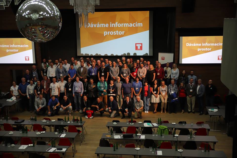
První dva dny v říjnu se konalo tradiční uživatelské setkání zákazníků společnosti T-Mapy. Na rozdíl od velkých setkání, typických například pro konference Esri, se jednalo o spíše menší akci, podle organizátorů okolo 135 účastníků z 62 organizací z Česka a Slovenska. Tato velikost však nebyla na škodu a ještě více podtrhovala “rodinnost” jak akce, tak […]
The post Uživatelské setkání T-Mapy očima GISportalu appeared first on GISportal.cz.
Inspektor Zeměměřického a katastrálního inspektorátu v Brně (obor služby 70.)
17.10.2018 7:21 ČÚZK /Urady/Zememericke-a-katastralni-inspektoraty/Zememericke-a-katastralni-inspektoraty/Zememericky-a-katastralni-inspektorat-v-Brne/Uredni-deska/Oznameni-a-jina-uredni-sdeleni/Volna-mista/Inspektor-Zememerickeho-a-katastralniho-inspek-(1)NIVA 21214 RZ 4B0 3905
17.10.2018 6:35 ČÚZK - předpisy a opatřeníKatastrální úřad pro Jihomoravský kraj nabízí nepotřebný majetek k odkupu. Jedná se o
NIVA 21214 RZ 4B0 3905
NIVA 21214 RZ 4B0 3905
17.10.2018 6:35 ČÚZK /Urady/Katastralni-urady/Katastralni-urady/Katastralni-urad-pro-Jihomoravsky-kraj/Nabidky-majetku/NIVA-21214-RZ-4B0-3905NIVA 21214 RZ 3B2 8028
17.10.2018 6:34 ČÚZK - předpisy a opatřeníKatastrální úřad pro Jihomoravský kraj nabízí nepotřebný majetek k odkupu. Jedná se o
NIVA 21214 RZ 3B2 8028
NIVA 21214 RZ 3B2 8028
17.10.2018 6:34 ČÚZK /Urady/Katastralni-urady/Katastralni-urady/Katastralni-urad-pro-Jihomoravsky-kraj/Nabidky-majetku/NIVA-21214-RZ-3B2-8028Bentley Systems Releases Open-Source Library: iModel.js
17.10.2018 2:00 Bentley SystemsOpen-source JavaScript library for creating immersive connections to
infrastructure digital twins
LONDON, U.K. – The Year in Infrastructure 2018 Conference – 17 October 2018 – Bentley Systems, Incorporated, the leading global provider of comprehensive software solutions for advancing the design, construction, and operations of infrastructure, today announced the initial release of its iModel.js library, an open-source initiative to improve the accessibility, for both visualization and analytical visibility, of infrastructure digital twins. iModel.js can be used by developers and IT professionals to quickly and easily create immersive applications that connect their infrastructure digital twins with the rest of their digital world. iModel.js is the cornerstone of Bentley’s just-announced iTwin™ Services that combine iModelHub, reality modeling, and web-enabling software technologies within a Connected Data Environment (CDE) for infrastructure engineering.
Bentley’s iModels have become a de facto standard for visibility into digital engineering models. iModelHub manages an iModel as a distributed database with an intrinsic ledger of changes—enabling alignment, accountability, and accessibility of its digital components—to form the backbone of an infrastructure digital twin.
The iModel.js library is a comprehensive collection of JavaScript packages that build on the most open, popular, and flexible standards for modern cloud and web development. It is written in TypeScript, and leverages open technologies including SQLite, Node.js, NPM, WebGL, Electron, Docker, Kubernetes, and of course HTML5 and CSS. The same codebase can produce cloud services and web, mobile, and desktop applications. The source code is hosted on GitHub and is distributed under the MIT license.
With iModel.js, it is simple to create a web-based experience that shows interactive “nD” views (1D, 2D, 3D, 4D, etc.) of iModels that are assembled and synchronized from BIM files and other digital engineering models, and from data created directly with iModel.js. Those same views can also include digital (reality) context, real-time sensor data, and other data from enterprise sources and analytics. Since the iModel is synchronized by iModelHub, it always reflects the most recent updates from all project participants, who are thus able to visualize and analyze changes between points in time or between versions. Importantly, only users and applications authorized by the iModel owner, through iModelHub, are granted access through iModel.js.
Johan Palm, program manager – Digital Project Delivery at Hatch, said, “iModel.js gives Hatch the ability to implement a stakeholder engagement technology that extends the iModelHub visionary technology. We can expose complex project information to a level that is accessible, consumable, and extendable via the cloud and in context to the 3D model. Most importantly we can do so in a manner that embraces change as the project progresses. iModel.js aligns with Hatch’s internal development strategies as it is built on modern, highly portable web technology. Bentley is a key software technology partner on Hatch projects globally where our main objective is to provide a positive impact to our client’s assets and operations.”
Cai Chengguo, chair and general manager, Shenzhen Expressway Consulting Group, said, “The digital twin powered by iModelHub is efficiently improving project management, substantially reducing the waste of resources caused by site problems and will achieve digital handover after completion of the project for visual operations and maintenance.”
Keith Bentley, Bentley Systems’ founder and CTO, said, “We firmly believe that iModel.js, and of course the foundation upon which it is built, is the most open, productive, intuitive, and powerful development environment for capital projects and infrastructure assets, ever. We’re excited to work with user organizations, strategic partners, and third-party developers to build an open ecosystem around iModels to tap the vast potential of infrastructure digital twins. With iModel.js, the well-refined techniques of mainstream cloud and web development can leverage the physical and virtual reality in digital twins with near-zero impedance. By open-sourcing the libraries we use to create our iTwin™ cloud services, we expect to foster a substantial and vibrant ecosystem of innovation.”
More about iModel.js: iModeljs.org
More about iModels and iModelHub: iModelHub.com
About Bentley Systems
Bentley Systems is the leading global provider of software solutions to engineers, architects, geospatial professionals, constructors, and owner-operators for the design, construction, and operations of infrastructure. Bentley’s MicroStation-based engineering and BIM applications, and its digital twin cloud services, advance the project delivery (ProjectWise) and the asset performance (AssetWise) of transportation and other public works, utilities, industrial and resources plants, and commercial and institutional facilities.
Bentley Systems employs more than 3,500 colleagues, generates annual revenues of $700 million in 170 countries, and has invested more than $1 billion in research, development, and acquisitions since 2012. From inception in 1984, the company has remained majority-owned by its five founding Bentley brothers. Bentley shares transact by invitation on the NASDAQ Private Market; strategic partner Siemens AG has accumulated a non-voting minority stake.
###
Bentley, the Bentley logo, AssetWise, Connected Data Environment, iTwin, MicroStation, and ProjectWise are either registered or unregistered trademarks or service marks of Bentley Systems, Incorporated or one of its direct or indirect wholly owned subsidiaries. All other brands and product names are trademarks of their respective owners.
Oznámení o částečném omezení provozu Pobočky Plzeň
17.10.2018 0:00 Státní pozemkový úřad Z důvodu malování kanceláří bude ve dnech úterý 30. 10. až úterý 6.11.2018 částečně omezen provoz Pobočky Plzeň (KPÚ pro Plzeňský kraj). Chod pobočky bude zajištěn.Minulý týden jsme se účastnili na pozvání setkání přátel civilního letectví na Ministerstvu dopravy
16.10.2018 21:53 UpVision Účastnili jsme se minulý týden příjemného setkání přátel civilního letectví na Ministerstvu dopravy k příležitosti 100 let vzniku republiky. Kromě detailní historie pražského letiště zazněly i vize jeho budoucnosti, včetně budoucího vývoje ŘLP a došlo samozřejmě i na drony.Zde více:
https://plus.google.com/u/0/b/115833877689730865211/+UpvisionCz1/posts/56Yi3sQ67cR
Invest in Murcia Launches First Online Business Location Analysis Service in Spain
16.10.2018 19:28 GISCafe.com Webcasts-Webinars GIS Planning software allows Region of Murcia to offer free, data-driven analysis to prospective businessesMURCIA, Spain, Oct. 16, 2018 — …
DJI Launches The Phantom 4 RTK Globally
16.10.2018 19:26 GISCafe.com Webcasts-Webinars SHENZHEN, China, Oct. 16, 2018 — (PRNewswire) — DJI, the world's leader in civilian drones and aerial imaging technology, today …Leidos awarded £26.9 million Scottish Government technology contract
16.10.2018 19:25 GISCafe.com Webcasts-Webinars EDINBURGH, Scotland, Oct. 15, 2018 — (PRNewswire) — Leidos (NYSE: LDOS), a FORTUNE® 500 science and technology company, has …Going Digital (Twins): Bentley Inaugurates iTwin™ Services!
16.10.2018 19:23 GISCafe.com Webcasts-Webinars Confluence of technologies enables project digital twins and performance digital twins for infrastructure engineering
LONDON — …
Maxar Technologies' DigitalGlobe Partners with Vodafone to Create an IoT Precision Agriculture Product
16.10.2018 19:22 GISCafe.com Webcasts-Webinars WESTMINSTER, CO, Oct. 16, 2018 — (PRNewswire) — DigitalGlobe, a Maxar Technologies company (NYSE: MAXR) (TSX: MAXR), today …Drone Aviation Delivers on $1.7 Million Contract for WASP Tactical Aerostat to U.S. Department of Defense
16.10.2018 19:21 GISCafe.com Webcasts-Webinars JACKSONVILLE, FL, Oct. 16, 2018 (GLOBE NEWSWIRE) -- Drone Aviation Holding Corp. (OTCQB: DRNE) (“Drone Aviation” or the …BAE Systems Successfully Demonstrates XTS Guard 5 for Military Cyber Security
16.10.2018 19:20 GISCafe.com Webcasts-Webinars RESTON, Va. — (BUSINESS WIRE) — October 16, 2018 — BAE Systems’ XTS® Guard 5, equipped with the company’s …Commercial Drone Poised to Emerge Game Changing in Drone Ecosystem through 2022, Says Fact.MR
16.10.2018 19:19 GISCafe.com Webcasts-Webinars Rockville, MD, Oct. 16, 2018 (GLOBE NEWSWIRE) -- DJI – the global drone leader, recently shipped 1000 Matrice drones equipped with machine …Blink Charging Co. Teams up with Google Maps
16.10.2018 19:18 GISCafe.com Webcasts-Webinars Blink Charging Co, a leading Electric Vehicle Charging Services Company, enhances its software to work seamlessly with Google Maps and makes it …Global Satellite Attitude and Orbit Control System Market 2018-2022 | Rise of Satellite-Aided Warfare to Promote Growth | Technavio
16.10.2018 19:17 GISCafe.com Webcasts-Webinars LONDON — (BUSINESS WIRE) — October 16, 2018 — The global satellite attitude and orbit control system market is expected to post a …GSA survey targets user-driven RPAS/Drones applications
16.10.2018 15:58 European GNSS Agency
The European GNSS Agency (GSA) is currently conducting a survey among operators and manufacturers of remotely piloted aircraft systems (RPAS) and aviation authorities with a view to better understanding user needs and identifying key requirements for future EGNSS upgrades and evolutions.
Various studies have shown the growing impact that RPAS will have on our daily lives. In fact, RPAS have already started bringing significant benefits all over Europe and the market is set to continue growing, in line with growth in the number applications. These applications come in a great variety including, but not limited to, delivery services, aerial photography and mapping, and precision agriculture.
Read this: EGNOS and Galileo – opening the door to new drone applications
Europe has the opportunity to obtain a significant role in this rapidly evolving global marketplace but, in order to unlock this opportunity actions are needed at the EU level to both boost innovative capabilities and implement comprehensive regulation to create a single drone market.
Have your say!
GNSS is the backbone technology underpinning the navigation solutions used for RPAS applications and this is expected to remain true in the future. For this reason, the GSA wants to make sure that EGNSS continues to meet the requirements and expectations of the RPAS user community. But, to do this, we need some input from you.
We have put together a short RPAS user requirements survey to help us better understand the needs and requirements of RPAS users. The survey consists of approximately 20 questions, and should not take longer than five minutes of your time to fill in. You can access the survey here – it will remain open until 30 November 2018, but there is no time like the present!
By filling in this survey, you will help the GSA to better understand user needs and the value that users attribute to GNSS. With this information, we can deduce the requirements of future EGNSS upgrades and evolutions. The survey is intended for all stakeholders in the RPAS value chain, but it is mainly focussed on operators, manufacturers of RPAS and navigation systems, and aviation authorities.
Media note: This feature can be republished without charge provided the European GNSS Agency (GSA) is acknowledged as the source at the top or the bottom of the story. You must request permission before you use any of the photographs on the site. If you republish, we would be grateful if you could link back to the GSA website (http://www.gsa.europa.eu).
GSA survey targets user-driven RPAS/Drones applications
16.10.2018 15:58 European GNSS AgencyThe European GNSS Agency (GSA) is currently conducting a survey among operators and manufacturers of remotely piloted aircraft systems (RPAS) and aviation authorities with a view to better understanding user needs and identifying key requirements for future EGNSS upgrades and evolutions.
Various studies have shown the growing impact that RPAS will have on our daily lives. In fact, RPAS have already started bringing significant benefits all over Europe and the market is set to continue growing, in line with growth in the number applications. These applications come in a great variety including, but not limited to, delivery services, aerial photography and mapping, and precision agriculture.
Read this: EGNOS and Galileo – opening the door to new drone applications
Europe has the opportunity to obtain a significant role in this rapidly evolving global marketplace but, in order to unlock this opportunity actions are needed at the EU level to both boost innovative capabilities and implement comprehensive regulation to create a single drone market.
Have your say!
GNSS is the backbone technology underpinning the navigation solutions used for RPAS applications and this is expected to remain true in the future. For this reason, the GSA wants to make sure that EGNSS continues to meet the requirements and expectations of the RPAS user community. But, to do this, we need some input from you.
We have put together a short RPAS user requirements survey to help us better understand the needs and requirements of RPAS users. The survey consists of approximately 20 questions, and should not take longer than five minutes of your time to fill in. You can access the survey here – it will remain open until 30 November 2018, but there is no time like the present!
By filling in this survey, you will help the GSA to better understand user needs and the value that users attribute to GNSS. With this information, we can deduce the requirements of future EGNSS upgrades and evolutions. The survey is intended for all stakeholders in the RPAS value chain, but it is mainly focussed on operators, manufacturers of RPAS and navigation systems, and aviation authorities.
Media note: This feature can be republished without charge provided the European GNSS Agency (GSA) is acknowledged as the source at the top or the bottom of the story. You must request permission before you use any of the photographs on the site. If you republish, we would be grateful if you could link back to the GSA website (http://www.gsa.europa.eu).
Ze Země na Měsíc: vzdělávací cesta vesmírem na podzimním učitelském workshopu ESA
16.10.2018 15:54 Český Kosmický PortálBěhem Světového kosmického týdne na počátku tohoto měsíce padesát učitelů základních a středních škol z různých členských zemí a spolupracujících států ESA sdílelo své zkušenosti a nechalo se inspirovat vesmírem na podzimním učitelském workshopu ESA.
Valné shromáždění EuroGeographics v Praze
16.10.2018 15:47 GeoBusiness Ve dnech 8. až 10. října 2018 se v Praze sešli zástupci mezinárodní organizace EuroGeographics, která sdružuje evropské národní mapovací, pozemkové a katastrální instituce. ... PřečístHybrid+ (What have they come up with now?)
16.10.2018 15:37 Carlson Software ……an advanced field solution for collecting data. When I first learned about this new module for SurvCE it was at the Go West user’s conference in San Diego last spring. I watched a demo of what was then a beta version of the software and being the practical application kind of person I am, was […]Den GIS na Katedře geoinformatiky
16.10.2018 13:21 15.11. Den GIS na Katedře geoinformatiky Seminář s praktickými ukázkami na počítačové učebně. Jedná se o 2hod. blok, který bude obsahovat krátké představení GIS a následně praktické ukázky využití GIS. Začátek jednotlivých bloků budou: 8:00, 10:10 a 12:30, příp. 14:40 (max. 36 studentů na 1 blok). DŮLEŽITÉ: Kapacita akce je omezena – nutná registrace na: […]Den GIS ve Světě techniky
16.10.2018 13:18 14.11. Den GIS ve Světě techniky Akce proběhne v prostorách Velkého světa techniky v Ostravě. 9:00 – malé povídání o GIS (doporučeno pro 2. stupeň ZŠ) 9:45 – krátká přednáška o GIS (doporučeno pro SŠ, VŠ) od 9:30 – akční blok: – expozice STC – ukázka geocachingu (start 10:30, Divadlo vědy) – lezecká stěna TENDON […]Phase One Industrial Launches 150MP Metric Camera and New Aerial Systems
16.10.2018 10:55 GISCafe.com Webcasts-Webinars iXM Platform with Advanced Imaging Sensors Delivers Superior Aerial MappingCOPENHAGEN, August 28, 2018 – Phase One Industrial, a leading …
Odborný referent v oddělení dokumentace katastru nemovitostí Katastrálního pracoviště Jičín
16.10.2018 9:26 ČÚZK - volná místa Katastrální úřad pro Královéhradecký kraj - Katastrální pracoviště Jičín vypisuje výběrové řízení na místo Odborný referent v oddělení dokumentace katastru nemovitostí Katastrálního pracoviště JičínOdborný referent v oddělení dokumentace katastru nemovitostí Katastrálního pracoviště Jičín
16.10.2018 9:26 ČÚZK /Urady/Katastralni-urady/Katastralni-urady/Katastralni-urad-pro-Kralovehradecky-kraj/Uredni-deska/Oznameni-a-jina-uredni-sdeleni/Volna-mista/Odborny-referent-v-oddeleni-dokumentace-katastru-nOdborný referent v oddělení dokumentace katastru nemovitostí Katastrálního pracoviště Jičín
16.10.2018 9:26 ČÚZK - předpisy a opatření Katastrální úřad pro Královéhradecký kraj - Katastrální pracoviště Jičínvypisuje výběrové řízení na místo
Odborný referent v oddělení dokumentace katastru nemovitostí Katastrálního pracoviště Jičín
uzavření kp pr 29.10.2018
16.10.2018 9:25 ČÚZK - předpisy a opatření Katastrální úřad pro Olomoucký kraj - Katastrální pracoviště Přerov zveřejnil novou aktualitu:OZNÁMENÍ.
V pondělí 29. října 2018 bude katastrální pracoviště z důvodu přerušení dodávky elektřiny provozovatelem distribuční soustavy společností ČEZ Distribuce, a.s. UZAVŘENO.
uzavření kp pr 29.10.2018
16.10.2018 9:25 ČÚZK - předpisy a opatření Katastrální úřad pro Olomoucký kraj - Katastrální pracoviště Přerov zveřejnil novou aktualitu: OZNÁMENÍ. V pondělí 29. října 2018 bude katastrální pracoviště z důvodu přerušení dodávky elektřiny provozovatelem distribuční soustavy společností ČEZ Distribuce, a.s. UZAVŘENO.Děkujeme za pochopení.
uzavření kp pr 29.10.2018
16.10.2018 9:25 ČÚZK /Urady/Katastralni-urady/Katastralni-urady/Katastralni-urad-pro-Olomoucky-kraj/Katastralni-pracoviste/KP-Prerov/O-uradu/Aktuality/uzavzeni-kp-pr-29-10-2018Reveal Relationships, Patterns in Microsoft Power BI (ArcNews Online)
16.10.2018 9:00 GISCafe.com Webcasts-WebinarsGeospatial Intelligence Center Mounts Large Scale Aerial Imaging Response to Hurricane Michael
16.10.2018 9:00 GISCafe.com Webcasts-Webinars GIC provided imagery less than 24 hours from collection, where it was made accessible to GIC member insurers, NOAA, FEMA, Red Cross and first …Aktualizace dat ÚAP od poskytovatele ČEZ Distribuce, a.s. a Telco Pro Services, a.s.
16.10.2018 8:30 Plzeňský kraj V datech územně analytických podkladů Plzeňského kraje byla provedena aktualizace dat technické infrastruktury od poskytovatele ČEZ Distribuce, a. s. a Telco Pro Services, a.s. Data jsou s platností k 1. 10. 2018.Crowdsourcing počtvrté a naposledy aneb zpět k traktorovému preciznímu zemědělství
16.10.2018 7:15 GISportal.cz
Závěrečný díl miniseriálu představuje historicky nejstarší z představených crowdsourcingových aplikací. První sledování zemědělských strojů v našich aplikacích, tj. traktoru a přípojného zařízení, započalo v roce 2014, kontinuální měření pro 9 traktorů a 23 přípojných zařízení probíhá kontinuálně na testovacích farmách od března 2015 dosud. Kromě toho spolupracujeme nejen v rámci projektu DataBio přímo se společností Zetor, a.s. Nástroje vizuální […]
The post Crowdsourcing počtvrté a naposledy aneb zpět k traktorovému preciznímu zemědělství appeared first on GISportal.cz.
rada/odborný rada v oddělení obnovy katastrálního operátu (3020) – obnova katastrálního operátu Kata
16.10.2018 6:32 ČÚZK /Urady/Katastralni-urady/Katastralni-urady/Katastralni-urad-pro-Jihocesky-kraj/Uredni-deska/Oznameni-a-jina-uredni-sdeleni/Volna-mista/rada-odborny-rada-v-oddeleni-obnovy-katastralnihorada/odborný rada v oddělení obnovy katastrálního operátu (3020) – obnova katastrálního operátu Kata
16.10.2018 6:32 ČÚZK - volná místa Katastrální úřad pro Jihočeský kraj - odbor obnovy katastrálního operátu vypisuje výběrové řízení na místo rada/odborný rada v oddělení obnovy katastrálního operátu (3020) – obnova katastrálního operátu Katarada/odborný rada v oddělení obnovy katastrálního operátu (3020) – obnova katastrálního operátu Kata
16.10.2018 6:32 ČÚZK - předpisy a opatření Katastrální úřad pro Jihočeský kraj - odbor obnovy katastrálního operátuvypisuje výběrové řízení na místo
rada/odborný rada v oddělení obnovy katastrálního operátu (3020) – obnova katastrálního operátu Katastrálního úřadu pro Jihočeský kraj
INSPIRE téma Rozšířené Parcely (CPX)
16.10.2018 2:00 Cenia - Katalog metadat ČR - INSPIRE Rozšíření má za cíl poskytovat katastrální mapu s obsahem podle vyhlášky ve vektorové podobě ve struktuře plně v souladu se strukturou danou směrnicí INSPIRE. Data rozšiřují směrnici INSPIRE pro téma katastrální parcely (CP) o věcná břemena, geodetické body, další prvky mapy, původní obloukovou geometrii a o parcely určené definičním bodem (ty pouze v oblastech s analogovou mapou). Vychází z katastrální mapy, která je závazným státním mapovým dílem velkého měřítka, obsahuje body polohového bodového pole, polohopis a popis a může mít formu digitální mapy, analogové mapy nebo digitalizované mapy. Publikovaná data obsahují katastrální území pro celou Českou Republiku, parcely a jejich hranice, věcná břemena, další prvky mapy a původní obloukovou geometrii z území, kde je digitální mapa (k 26. 11. 2018 je to 96,16% území České republiky, t.j. 75 840,00km2) a ve zbytku území katastrální parcely určené pouze definičním bodem (tedy bez hranic a polygonu). Katastrální parcely a hranice obsahují oproti datové sadě INSPIRE některé atributy navíc. Jedná se o typ hranice, způsob využití území, druh pozemku, vazbu na budovu a o mapové značky. Více katastrální zákon 344/1992 SB., katastrální vyhláška č.26/2007 Sb. v platném znění a INSPIRE Data Specification on Cadastral Parcels v 3.0.1. Data ve formátu GML 3.2.1 jsou validní proti schématu XML pro Rozšířené Parcely (CPX) ve verzi 4.0.Going Digital (Twins):<br> Bentley Inaugurates iTwin™ Services!
16.10.2018 2:00 Bentley SystemsConfluence of technologies enables project digital twins and performance digital twins for infrastructure engineering
LONDON, U.K. – The Year in Infrastructure 2018 Conference - 16 October 2018 – Bentley Systems, Incorporated, the leading global provider of comprehensive software solutions for advancing the design, construction, and operations of infrastructure, today announced the forthcoming availability of iTwin™ Services, digital twin cloud services for infrastructure projects (project digital twins) and assets (performance digital twins). iTwin™ Services can be transparently provisioned within Bentley’s Connected Data Environment (CDE) for ProjectWise and AssetWise users.
Requirements for Realizing the Potential of Infrastructure Digital Twins
Infrastructure asset owners and their teams have recognized the potential for leveraging digital twins in many ambitious use cases including the application of analytics, artificial intelligence (AI) and machine learning (ML) in simulations and decision support throughout the lifecycle of design, construction, and operations. To realize this potential, representations of assets need obviously to be digital—but to be safely relied upon as a twin there must be practical solutions for their synchronization to changing actual conditions in the real world. Moreover, merely capturing and representing physical conditions, including IoT inputs, can never be sufficient to understand, analyze, or model intended improvements, without also comprehending the “digital DNA” captured in the project or asset’s engineering specifications.
To actually be worthwhile, therefore, would-be digital twins for existing infrastructure must reliably synchronize reflections of both an asset’s physical reality, and its “virtuality” (engineering data). A digital twin can meet this requirement by geospatially converging the digital context (representing the physical) and digital components (representing the virtual), naturally resulting in an immersive environment for both visualization and analytics visibility.
To date, however, the evolving 3D physical reality of an as-operated asset has been too formidably difficult to capture digitally, let alone to keep up-to-date. Meanwhile, corresponding, as-operated engineering information tends to be unavailable or at best, dated, as typically an assortment of effectively inaccessible “dark data” in either opaque engineering files or unintelligent document formats. Bentley has now surmounted both of these challenges, with the confluence of its reality modeling, iModelHub, CDE, and web-visibility technologies.
Reality Modeling
A representation of any infrastructure asset’s physical reality can now be reliably captured and maintained through increasingly continuous surveys and Bentley’s reality modeling software, providing digital context in the form of “reality meshes”. Overlapping photographs and (as needed) supplemental laser scans, largely from drones and ground-level imagery, are processed to generate spatially-classified and engineering-ready reality meshes at any desired level of accuracy—within which each digital component can be automatically recognized and/or geospatially referenced. The reality mesh can provide an efficient and immersive visual “twin” to intuitively navigate for finding, viewing, and querying the associated information within, or related to, the asset’s digital engineering models.
Adding iModelHub within CDE
The challenge in comparably capturing and maintaining these engineering counterparts of the physical asset— its digital components—is the opacity of their existing representations, compounded by continuous changes. Bentley’s iModelHub, introduced in 2017, overcomes these hurdles through automated digital alignment (to achieve semantic consistency from otherwise dark data in known formats), and synchronization, based on change ledgers, corresponding to the CDE’s project workflows (ProjectWise) or configuration management (AssetWise).
Web Visibility
Once populated and synchronized by way of digital context and digital components, iTwin™ Services deliver their benefits through Bentley’s new (separately announced) open-source iModel.js library (iModeljs.org) for web-based immersive visualization. Infrastructure teams can easily develop custom applications that connect their digital twin for specific use cases by leveraging a vast open source ecosystem. In addition, a geospatially immersive environment for city-scale digital twins is now available through Bentley’s new OpenCities Planner services.
Introducing Project Digital Twins
ProjectWiseCONNECT Edition users of Bentley’s CDE can instantiate cloud-provisioned iTwin™ Services for any project without disruption to their existing ProjectWise workflows. iModelHub will then transparently create and maintain the project’s comprehensive iModel: a distributed database, with its intrinsic change ledger updated at each deliverable-in-progress check-in state. For each such update to engineering information, application-specific “information bridge” processing effectuates digital alignment of the iModel’s digital components.
To the extent of available reality modeling for the physical site, the CDE’s corresponding ContextShare service maintains updated digital context. The iModel’s digital components and ContextShare digital context are immersively merged through Navigator Web and iModel.js visualization, as authorized and secured by iModelHub.
Accordingly, iTwin™ Services enable comprehensive project status reviews to be continuously available, synchronized to any requested project state on the iModel change ledger timeline, and/or for visualization and analytics visibility into changes between any project timeline states. iTwin™ Services will also integrate Bentley’s SYNCHRO 4D construction modeling.
iTwin™ Services for project digital twins will be available early in 2019, with quarterly base subscription charges for each iTwin™ based upon its scale, in terms of digital components and digital context, and inclusive of cloud provisioning and web accessibility.
Adding Performance Digital Twins
The iModel.js library supports functionality to create and curate iTwins fit for particular asset performance purposes, including “agent” updating of “data lakes” for analytics visibility. This enables emerging AI and mixed reality technologies to be advantageously applied throughout an asset’s lifecycle, and across assets—relying, for assured fidelity spanning physical reality and engineering data, upon the necessary digital alignment, change synchronization, and immersive visualization uniquely provided by iTwin™Services.
Also at the Conference, Siemens and Bentley unveiled PlantSight™, a new range of cloud services to be jointly offered for as-operated digital twins of any process plants. PlantSight will provide increasingly comprehensive as-operated digital twin services, to incorporate Bentley’s AssetWise APM with Siemens’ operational technologies, MindSphere, and Teamcenter, for industrial plants’ asset performance modeling. And to accelerate owners going digital, Atos and Bentley announced a new strategic partnership to create and curate performance digital twins.
Keith Bentley, Bentley Systems founder and CTO, said “Our work with early adopters of iModelHub over the past year has confirmed to me that its unique strengths for alignment, accountability, and accessibility find their highest and best use, in conjunction with our reality modeling technologies, for enabling project digital twins and performance digital twins. I look forward to actively working with users and external developers to create an open ecosystem of innovation for iTwin™Services, leveraging the iModel.js library. I expect Bentley Systems to lead the infrastructure engineering community, as the ‘infrastructure digital twin’ company!” Learn More.
About Bentley Systems
Bentley Systems is the leading global provider of software solutions to engineers, architects, geospatial professionals, constructors, and owner-operators for the design, construction, and operations of infrastructure. Bentley’s MicroStation-based engineering and BIM applications, and its digital twin cloud services, advance the project delivery (ProjectWise) and the asset performance (AssetWise) of transportation and other public works, utilities, industrial and resources plants, and commercial and institutional facilities.
Bentley Systems employs more than 3,500 colleagues, generates annual revenues of $700 million in 170 countries, and has invested more than $1 billion in research, development, and acquisitions since 2012. From inception in 1984, the company has remained majority-owned by its five founding Bentley brothers. Bentley shares transact by invitation on the NASDAQ Private Market; strategic partner Siemens AG has accumulated a non-voting minority stake.
# # #
Bentley, the Bentley logo, AssetWise, Connected Data Environment, ContextCapture, iModel, iModelHub, iTwin, MicroStation, Navigator Web, OpenCities Planner, ProjectWise, and SYNCHRO are either registered or unregistered trademarks or service marks of Bentley Systems, Incorporated or one of its direct or indirect wholly owned subsidiaries. PlantSight is a trademark of Siemens AG and Siemens PLMS Inc. All other brands and product names are trademarks of their respective owners.
Carlson Connect now available for AutoCAD 2019
15.10.2018 23:18 Carlson Software MAYSVILLE, Kentucky, U.S.A. (October 2018) — Carlson Connect 2019 is now available on the Autodesk App Store, apps.autodesk.com, for $7.99. A collection of routines for transferring and converting data between Autodesk® Civil 3D®, and Carlson SurvCE and Carlson Survey, Carlson Connect 2019 runs within Civil 3D 2019 and uses the current Civil 3D data model. […]Carlson Introduces Hybrid+ as a Module for SurvCE/SurvPC 6.0
15.10.2018 22:37 Carlson Software MAYSVILLE, Kentucky, U.S.A. (October 2018) — Carlson Software introduces Hybrid+, a new paid module for SurvCE/SurvPC 6.0 that allows users to survey using both GPS and Total Station at the same time with all SurvCE compatible drivers. The Hybrid+ module incorporates a series of specially designed features to take advantage of the new multi-sensor setup […]Hybrid+ Surveying Case Study: Bringing Geodetic Coordinates Inside for Rodded Boretrak® Testing
15.10.2018 20:19 Carlson Software Available new in SurvCE and SurvPC 6.0 is powerful Hybrid+ Surveying, which is a mixed use of GNSS and robotic total station measurements. One of the many attractive features of Hybrid+ Surveying is GNSS Resection by Total Station. In July 2018, we used this feature to bring true geodetic coordinates, with true north azimuth, into […]Lead’Air Inc to introduce innovative TRACK’AIR ™ 2019 products and services at the Frankfurt 2018 Intergeo
15.10.2018 17:11 GISCafe.com Webcasts-Webinars 1)The MIDAS 2019 (Multi-Sensor Integrated Digital Airborne System). MIDAS can be configured to generate 5 cm (2 inches) GSD from 1,000 to 10,000 feet …Harris Corporation Reports Strong Fiscal 2019 First Quarter Results With Accelerated Revenue Growth Across All Segments
15.10.2018 16:53 GISCafe.com Webcasts-Webinars Revenue up 9% to $1.5 billion with a book-to-bill of 1.3EPS from continuing operations up 31% to $1.78
Operating cash flow up 23% to $117 million; …
Atos and Bentley Systems Announce Strategic Partnership to Create Digital Twins for Owner-operators of Industrial and Infrastructure Assets
15.10.2018 16:51 GISCafe.com Webcasts-Webinars LONDON — (BUSINESS WIRE) — October 15, 2018 — The Year in Infrastructure 2018 Conference – Atos, a global leader in digital …Bentley Acquires Agency9 to Realize Digital Twins for Every City
15.10.2018 16:50 GISCafe.com Webcasts-Webinars OpenCities Planner takes advantage of city-scale reality modeling to span GIS and BIMLONDON — (BUSINESS WIRE) — October 15, 2018 …
Siemens and Bentley Systems Announce PlantSight™ Digital Twin Cloud Services
15.10.2018 16:49 GISCafe.com Webcasts-Webinars Solution enables up-to-date, as-operated digital twins − synchronizing the real plant and its engineering representations − for more …Alteryx Announces Date of Third Quarter 2018 Financial Results Release
15.10.2018 16:48 GISCafe.com Webcasts-Webinars IRVINE, Calif. — (BUSINESS WIRE) — October 15, 2018 — Alteryx, Inc. (NYSE: AYX), revolutionizing business through data science and …Textron Aviation and NetJets Strengthen Industry-Leading Relationship with Option to Expand Fleet with Citation Longitude and Citation Hemisphere Jets
15.10.2018 16:47 GISCafe.com Webcasts-Webinars ORLANDO, Fla. — (BUSINESS WIRE) — October 15, 2018 — Textron Aviation Inc., a Textron Inc. (NYSE:TXT) company, and NetJets® …Topcon and Bentley Strengthen Constructioneering Initiatives and Programs
15.10.2018 16:47 GISCafe.com Webcasts-Webinars Constructioneering Academies expand insights, create changeLONDON — (BUSINESS WIRE) — October 15, 2018 — The Year in …
Kratos Partners with Harris Corporation to Bring Advanced Hand Held Radios to the Warfighter
15.10.2018 16:46 GISCafe.com Webcasts-Webinars Licensing Agreement Incorporates Kratos-Developed CDL Waveforms into Harris Tactical Radios for Enhanced ISR CapabilitiesSAN DIEGO, Oct. 15, 2018 …
Dell Expands UltraSharp Monitor Family with Innovations and Workforce Transformation in Mind
15.10.2018 16:45 GISCafe.com Webcasts-Webinars Dell UltraSharp monitors offer innovative design and technology, superb screen performance driving productivity for financial traders, bankers, …20181015 odborný referent v oddělení aktualizace a dokumentace KN
15.10.2018 16:05 ČÚZK - předpisy a opatření Katastrální úřad pro Středočeský kraj - Katastrální pracoviště Nymburk Vyhlášení výběrového řízení: odborný referent v oddělení aktualizace a dokumentace KN V části "Úřední deska", v sekci "Oznámení a jiná úřední sdělení" bylo vystaveno "Oznámení o vyhlášení výběrového řízení na obsazení systemizovaného místa odborný referent v oddělení aktualizace a dokumentace KN"20181015 odborný referent v oddělení aktualizace a dokumentace KN
15.10.2018 16:05 ČÚZK /Urady/Katastralni-urady/Katastralni-urady/Katastralni-urad-pro-Stredocesky-kraj/Katastralni-pracoviste/KP-Nymburk/O-uradu/Aktuality/20161013Rada-odborny-rada-–-informatik-(1)odborný referent v oddělení aktualizace a dokumentace KN
15.10.2018 16:04 ČÚZK - volná místa Katastrální úřad pro Středočeský kraj - Katastrální pracoviště Nymburk vypisuje výběrové řízení na místo odborný referent v oddělení aktualizace a dokumentace KNodborný referent v oddělení aktualizace a dokumentace KN
15.10.2018 16:04 ČÚZK /Urady/Katastralni-urady/Katastralni-urady/Katastralni-urad-pro-Stredocesky-kraj/Volna-mista/odborny-referent-v-oddeleni-aktualizace-a-dokumentodborný referent v oddělení aktualizace a dokumentace KN
15.10.2018 16:04 ČÚZK - předpisy a opatření Katastrální úřad pro Středočeský kraj - Katastrální pracoviště Nymburkvypisuje výběrové řízení na místo odborný referent v oddělení aktualizace a dokumentace KN
odborný referent v oddělení aktualizace a dokumentace KN
20181015-GaKO-10-2018
15.10.2018 15:27 ČÚZK - předpisy a opatření Český úřad zeměměřický a katastrální zveřejnil novou aktualitu: Aktuální číslo Geodetického a kartografického obzoru (10/2018) je k dispozici ke stažení.
Nové číslo GaKO
15.10.2018 14:30
ÚGKK SR
Nové číslo časopisu Geodetického a Kartografického Obzoru 10/2018
ERL Emergency 2019 – robots to the rescue!
15.10.2018 13:56 European GNSS Agency
In emergency situations, robotic systems play a key role in providing rescue teams with remote access to an emergency site. The ERL Emergency Local Tournament 2019 aims to foster advanced developments of autonomous capabilities and seamless navigation for emergency robotic systems.
The European Robotics League (ERL) is an innovative robot competition that stems from its predecessors - the euRathlon and RoCKIn competitions - and focuses on tasks that robots must execute in realistic emergency situations. The competition is composed of multiple local tournaments, held in different locations across Europe, in addition to a few major events.
The first of the challenges was announced in July 2018, and focused on land and sea robotic systems. The second, to be held in February 2019 at the premises of the Advanced Centre for Aerospace Technologies (CATEC) in Seville, Spain, will include air and land robots working in an outdoor/indoor environment. You can find more information about the challenges here.
Read this: Integrating GNSS in UAVs for faster SAR
Teams participate in a minimum of two tournaments (local and/or major) per year and get scores based on their performances. Each team’s top two tournament scores are then added together and the teams are ranked based on their cumulative score. Prizes for the top teams are awarded at the following year’s European Robotics Forum (ERF).
GSA Special Prize
The European Global Navigation Satellite Systems Agency (GSA) will award a special prize at ERL Emergency 2019 focusing on robots that make use of solutions based on Galileo and EGNOS.
For air robots, this challenge will involve two types of tasks: horizontal accuracy in landings at a specific geographic coordinate; and vertical accuracy while hovering at a specific geographic coordinate. For land robots, there will be only one type of task - horizontal accuracy during waypoint-based navigation.
Visual markers will be used to support the assessment of both types of task. To be eligible for the award, a team must have executed valid trials of the tasks. The team deemed to have achieved the best results will be declared the winner. For information on Galileo capable receivers and navigation kits for robotic systems visit https://www.usegalileo.eu/EN/.
Register now!
If you are interested, on 22nd October 2:00 PM - 4:30 PM CEST we will be holding a webinar on 'How to submit a winning proposal for the Emergency 2019 – robots to the rescue, competition!'
You can register to the webinar here.
Ready to join the ERL Emergency Local Tournament? Register your team here by the deadline of 29 October 2018.
Media note: This feature can be republished without charge provided the European GNSS Agency (GSA) is acknowledged as the source at the top or the bottom of the story. You must request permission before you use any of the photographs on the site. If you republish, we would be grateful if you could link back to the GSA website (http://www.gsa.europa.eu).
Program konference
15.10.2018 10:06 ARCDATANa stránkách Konference GIS Esri v ČR nyní naleznete časový harmonogram jednotlivých sekcí a můžete si přečíst abstrakty přihlášených příspěvků.
Vedle podrobného programu jsme připravili i časový rozvrh tematických miniseminářů, které se budou opět konat na stánku technické podpory. Z doprovodného programu se pak můžete těšit třeba na oblíbené postery, výstavu ke stému výročí založení československé vojenské zeměpisné služby a pětistému výročí Klaudyánovy mapy.
Byli jsme jedním ze sponzorů i řečníků v bloku Letectví odborné konference Doprava 2018+
15.10.2018 9:01 UpVision Byli jsme jedním ze sponzorů i řečníků v bloku Letectví odborné konference Doprava 2018+, která se včera konala v Praze pod záštitou ministra dopravy. Akce se s námi účastnil i CEO AirMapu David Hose a naše reklamní vlaštovka zaujala i Českou televizi. :-)Fotky zde:
https://plus.google.com/u/0/b/115833877689730865211/+UpvisionCz1/posts/87F1feubLHV
INSPIRE info day
15.10.2018 9:01 CENIA - národní geoportál INSPIRE INSPIRE info day pořádá CENIA, česká informační agentura životního prostředí v budově ČÚZK (Pod sídlištěm 1800/9, Praha 8, stanice metra C Kobylisy). Čas 10.00 - 15.00. Program bude zveřejněn v průběhu listopadu.Contex to Preview New Products at VIP Event in Las Vegas
15.10.2018 9:00 GISCafe.com Webcasts-Webinars Attendees to Experience the Latest in Wide Format Scanning and PrintingChantilly, VA — October 12, 2018 — Contex, the world …
Orbit GT signs strategic Smart Mapping deal with Singapore Land Authority at Embassy
15.10.2018 9:00 GISCafe.com Webcasts-Webinars Singapore, October 11th, 2018 -- Orbit GT and the Singapore Land Authority (SLA) signed a strategic and comprehensive deal at the Belgian …A More Informed View of City Business (ArcUser Online)
15.10.2018 9:00 GISCafe.com Webcasts-WebinarsKonference Otevřená data
15.10.2018 8:53 CENIA - národní geoportál INSPIRE Konference Otevřená data v Národní technické knihovně v Praze v čase 9.00 - 15.00. Program naleznete na stránkách konference. Registrace zde.INSPIRE info day
15.10.2018 8:53 CENIA - národní geoportál INSPIRE INSPIRE info day pořádá CENIA, česká informační agentura životního prostředí v zasedací místnosti Českého úřadu zeměměřického a katastrálního (Pod sídlištěm 1800/9, Praha 8). Čas 10.00 - 15.00. Program bude zveřejněn v průběhu listopadu.Ako GIS mení svet – 1000 GIS aplikácií
15.10.2018 8:30 GISportal.cz
GIS sú silným nástrojom, ktorý nájde domov takmer v každej disciplíne na svete. Milióny rozhodnutí sú podporované pomocou GIS. Pekný pohľad na GIS a jeho využitie v širokom spektre disciplín dáva nasledujúci sprievodca 1000 GIS aplikáciami (odkaz na stránku je dostupný tu). Je možné tu nájsť napr. rôzne prípadové štúdie, taktiež inšpiráciu pre rôzne študentské/podnikateľské GIS projekty […]
The post Ako GIS mení svet – 1000 GIS aplikácií appeared first on GISportal.cz.
Podzimní termíny školení open source GIS od GISMentors (PR)
15.10.2018 7:55 GISportal.cz
GISMentors vypsali na tento podzim celkem 6 kurzů open source GIS. Kurzy pokrývají spektrum desktop GIS (QGIS pro začátečníky a pokročilé, GRASS GIS pro začátečníky), databáze (PostGIS a PostgreSQL pro začátečníky) a zpracování prostorových dat v jazyce Python. Přihlaste se na kurz včas pro menší kurzovné , termíny se blíží. Pokud je vás skupina nebo máte zájem o více kurzů, neváhejte nás […]
The post Podzimní termíny školení open source GIS od GISMentors (PR) appeared first on GISportal.cz.
Nabídka témat bakalářských a diplomových prací [Katedra aplikované geoinformatiky a kartografie, byTopic]
15.10.2018 7:35 Katedra aplikované geoinformatiky a kartografie Přf UK Témata bakalářských a diplomových prací vypsaných pro školní rok 2018-2019 na katedře aplikované geoinformatiky a kartografie.Mapová aplikace
15.10.2018 7:30 Ústecký krajNově byla zpracována mapová aplikace"Rozhledny a vyhlídky v ÚK" Mapová aplikace Vás provede něk olika zajímavými místy, odkud jsou krásné výhledy do krajiny. Ať navštívíte nějakou vyhlídku či jednu z mnoho rozhleden v kraji, pohledy z nich Vás nikdy nezklamou a pokud se budet chtít s ostaními o výhled podělit, můžete nám zaslat pořízené foto a my ho můžeme zveřejnit.
Mapovou aplikaci naleznete na úvodní straně a také v sekci MAPY - > Turistika a cestovní ruch- > Rozhledny a vyhlídky v Ústeckém kraji.
Immersive Digital Twins Help Hubei Engineers Virtualize the Design of a 220-kilovolt Transmission Line
15.10.2018 2:00 Bentley SystemsThe Cha’anling-Ziaojiazhou region in China’s Zianning District is a highly developed region and home to 350,000 consumers of electricity. Historically, the region has experienced unreliable power supply, making consumer delivery unstable. Cha’anling-Ziaojiazhou is highly urban, with complex topology complicating the task of adding new power lines. Moreover, major highways that cross the region complicate the ability to add new transmission lines without impacting commercial and residential traffic. Further complicating potential improvements, the region borders the flood diversion area of the Yangtze River, meaning that potential flooding around future towers must be accounted for from the beginning. These factors mean that finding a solution to deliver improved power requires a new approach.
The Hubei Provincial Electric Power Survey and Design Institute was tasked with designing and delivering a new 220-kilovolt transmission line to provide power for a newly constructed substation in Xiaojiazhou. This transmission line is a significant step for improving the lives of the 350,000 daily users in Jiayu County. However, the obstacles that faced the Design Institute are significant. To solve these challenges, the engineering teams began by creating a fully immersive digital twin of the affected regions using ContextCapture. Modeling the entire region, including multiple cities and highways, established an immersive digital baseline from which the design studies could be made. Leveraging Bentley’s OpenBuildings Designer, Bentley Substation, and STAAD.Pro, Hubei’s engineers created a digital engineering model of the transmission line, which could be added to and combined with the immersive digital twin to visualize the new line and identify potential obstacles and issues. Analyses of the design could be performed and optimized to ensure that the new towers were structurally sound, to minimize interference with the urban and traffic areas, and to reduce design time compared to previous methods. The resulting design, leveraging Bentley’s iModel technology, was fully deployable into a three-dimensional earth view, ensuring that multiple stakeholders could review the planned route and design.
Implementing a completely digital workflow combined with immersive models has paid significant dividends during the design phase. In addition to increasing online collaboration, planned design time was reduced by 12 percent, checking time by 16 percent, and planned field work by five days. The design saved six houses in the region from being demolished, while ensuring that each of the major crossing areas were optimally designed. Design optimizations resulted in savings of material costs, with the new tower designs reducing weights by 1.2 percent and the total route length decreasing by half of a kilometer.
Through increased collaboration with contractors and design departments, design reviews to reduce conflicts between towers, lines, and the environment were optimized, reducing future rework and in-field problems. Using a digital design and collaboration model, the Hubei Provincial Electric Power Survey and Design Institute realized savings of more than CNY 6 million on a CNY 32.21 million project. The Hubei Provincial Electric Power Survey and Design Institute’s transformation to a digital environment has resulted in a design that not only saves money but also improves the lives of the residents in the Xianning District while preserving the environment.
Liang Zhang, an engineer with POWERCHINA Hubei Electric Engineering Corporation Limited, said, “The innovative use of Bentley software for the design of overhead electric transmission lines reduced design time by approximately 40 hours through multidiscipline collaboration. The full electric transmission line pole tower layout model, supported by the reality model, reduced the checking and auditing time by 32 hours. About 12 percent of the total design time and 16 percent of the checking time were reduced.”CCCC Creates a Digital Twin to Build a New Digital City in China
15.10.2018 2:00 Bentley SystemsAs part of a coordinated development plan, Zhongguancun will integrate the resources of Beijing, Tianjin, and Zhongguancun to build a new science and technology city. The CNY 2.2 billion project includes the design and construction of roads, utility pipelines, a 174,000-square-meter park, and green roadsides spanning 477,000 square meters. Given the large geographic span, wide construction area, and tight construction timeline, the overall project consultant CCCC Water Transportation Planning Design Institute (CCCC) implemented a collaborative BIM process to coordinate the many engineering disciplines to deliver the new digital city.
In keeping with the idea of a truly digital city that incorporates a municipality’s needed services, the project scope encompasses a wide range of utility, transportation, and environmental disciplines. Included within the project scope is the construction of 16 roads with a length of approximately 30 kilometers; a layout of rain and sewage diversion pipelines with a length of approximately 78 kilometers; water supply pipelines with a length of approximately 40 kilometers; intermediate water pipelines with a length of approximately 26 kilometers; gas pipelines with a length of approximately 43 kilometers; thermal power pipelines with a length of approximately 40 kilometers; power pipelines with a length of approximately 45 kilometers; and telecommunication pipelines with a length of approximately 39 kilometers. Additionally, the project team is responsible for designing and constructing a city park with an area of approximately 174,000 square meters. The roadside will be green with an area of approximately 477,000 square meters, and the river and water environment will be comprehensively improved. CCCC acts as the overall consultant and implementer of the BIM process on this project. The organization is responsible for the creation and application of BIM technology in the design, construction, and operation and maintenance of models in all stages. CCCC is responsible for setting up a BIM project management platform, building project digital assets, and assisting the construction of the regional smart park and smart city.
Using Bentley’s integrated BIM applications, including ContextCapture, LumenRT, MicroStation, Navigator, OpenBridge Modeler, OpenRoads, ProjectWise, ProStructures the team generated a comprehensive 3D model of the entire city. CCCC identified and remedied more than 200 collision points, optimizing design and reducing costly rework. Performing construction simulation facilitated construction management, shortening the construction period by 64 days to save CNY 6.6 million in costs. ProjectWise provided a connected data environment to streamline workflows and improve design efficiency. Integrating ContextCapture to generate a reality mesh from UAV terrain data collected on site enabled the team to facilitate earthworks planning, saving approximately CNY 40 million.
BIM Methodologies Help Beijing Water Increase Water Distribution in Northern China
15.10.2018 2:00 Bentley SystemsThe South-to-North Water Diversion Project is a major foundational strategic project to alleviate the severe shortage of water resources in northern China, especially in the capital of Beijing, to optimize the allocation of water resources, and to support the development of Beijing and Tianjin. The Beijing Institute of Water was tasked with this CNY 3.4 billion project to support the Hexi Branch sub-project in creating construction drawings of multiple pumping stations, water transmission lines, and water treatment plants.
Leveraging BIM methodologies to manage the design and information management, the entire system was designed using 3D modeling and Bentley’s ProjectWise as the central collaboration environment. From these design models, construction drawings and secondary design analyses were conducted using MicroStation for annotation and rebar assessment, greatly improving the efficiency of creating detailed drawings. In addition, the project team used Descartes to create surface digital engineering models and building models, allowing the team to track construction completion digitally, rather than relying on paper queries for information.
Bentley’s HAMMER was used to analyze and calculate the hydraulic transition between the pumping stations and to calculate pressure distribution along the path in case of pump shutdown, ensuring that the system can operate safely under any circumstance. Three-dimensional geological models of the entire site using MicroStation resulted in 60 percent faster modeling times compared to previous 2D methodologies. This process also enabled the direct creation of a complex pipeline mesh model to calculate the shortest clear directions to optimize the design and protection of various pipelines. This innovative, first-of-a-kind approach saved 80 percent in design time compared to previous 2D methods.
By combining full lifecycle management concepts, the Hexi branch project carried out design work of intelligent water in the initial design phase. From this intelligent water design, the project has developed a strong technical basis to support operation of the project through leveraging 3D collaborative design results, building reliable model information archives and enabling the project to fully realize digital design, digital construction management, and digital operations.
Xin Yin, chief engineer of the Information Center for the Institute, stated, “This project is not only an example of 3D application in water supply engineering for an urban long-distance tunnel, but it is also a successful 3D practice in design, construction, and management. Taking this project as a symbol, we will lead 3D design trends in long-distance, super-large-pipe water transmission engineering, ushering in a new era in the industry in which 3D collaborative design is widely applied to the field of water conservancy design.”Topcon and Bentley strengthen constructioneering initiatives and programs
15.10.2018 2:00 Bentley SystemsConstructioneering Academies expand insights, create change
LONDON – The Year in Infrastructure 2018 Conference – October 15, 2018 – Topcon Positioning Group, a world leader in positioning technology for the survey and construction industries, and Bentley Systems, the leading global provider of comprehensive software solutions for advancing the design, construction, and operations of infrastructure, announce new developments in the constructioneering workflow initiative.
Constructioneering Academy
The Bentley Year in Infrastructure Conference 2018 (YII) marks the first anniversary of the launch of the Constructioneering Academy initiative of Topcon and the Bentley Institute. The program has been held in multiple locations across North America and Australia throughout the first year and now expands into Europe with the first London-based Constructioneering Academy, part of the YII.
“The Constructioneering Academies are filled with a mix of professionals from companies, governmental agencies and organizations who are involved in putting important infrastructure projects into motion and seeing them through to completion. The uniqueness of the dialogue taking place among participants, representing more than 80 organizations in the first year, cannot be overstated,” said Ewout Korpershoek, executive vice president of Topcon Positioning Group. “The program’s educational and collaborative atmosphere is creating awareness of potential productivity gaps that can be encountered on a project, and how those gaps can be filled, resulting in a paradigm shift in how work can be accomplished.”
Alan Lamont, Bentley Systems’ vice president for Digital Advancement Academies, said, “The active participation and feedback that we have experienced during the various Constructioneering Academy events have been very informative and encouraging. The level of interest and feedback demonstrate that there is a clear need for automated digital workflows between design and construction to help project teams be more efficient and avoid mistakes. We look forward to expanding the reach of Constructioneering Academies to other geographic locations.”
“We are looking forward to building upon the success of the inaugural year of the Constructioneering Academy,” said Ron Oberlander, vice president of Global Professional Services for Topcon Positioning Group. “The industry needs these types of programs as a catalyst to drive digital automation adoption. A key part of the initiative is the interaction of field and office professionals from the ‘front lines’ and we are excited to provide this opportunity to professionals around the world.
“We believe the Constructioneering Academies are truly fostering progress. For the industry to be successful in meeting future infrastructure demands, we have to change the mindsets and processes on how we approach construction. What Topcon and Bentley have initiated and will continue to evolve is an exciting journey to help shape that change,” Oberlander said.
As additional dates and locations for the Constructioneering Academy become available, they will be provided at constructioneering.com/academy.
Integration agreement
As part of the ongoing constructioneering initiative, the companies have signed an agreement that will integrate the Topcon point cloud and 3D mesh service, MAGNET Collage Web, with the Bentley ContextCapture Cloud Processing Service. The Bentley cloud service enables operators to upload UAV imagery direct-to-web without the need for high-end hardware requirements or IT constraints. Topcon instrument, control systems and software users will benefit from an industry-leading, cloud-based photogrammetric engine for fast generation of 3D engineering-ready reality meshes and digital surface models.
Ted Lamboo, senior vice president of Bentley’s strategic partnerships, said, “We are very pleased with Topcon’s expanded commitment, through MAGNET Collage Web integration, to Bentley’s ContextCapture reality modeling cloud services. Now, all of Topcon’s positioning technologies can help to continuously survey a site’s digital context, synchronizing project digital twins to make constructioneering even more compelling.”
“The agreement for a web-based integrated workflow solution is an excellent example of the ongoing collaboration of Topcon and Bentley to simplify and speed up digital construction workflows,” Korpershoek said. “Through our partnership, we are continuously working together to create new solutions to improve survey, engineering, and construction processes.”
About Topcon Positioning Group
Topcon Positioning Group is headquartered in Livermore, California, U.S. (topconpositioning.com). Its European head office is in Capelle a/d IJssel, the Netherlands. Topcon Positioning Group designs, manufactures and distributes precision measurement and workflow solutions for the global construction, geospatial and agriculture markets. Its brands include Topcon, Sokkia, Tierra, Digi-Star, RDS Technology, and NORAC. Topcon Corporation (topcon.com), founded in 1932, is traded on the Tokyo Stock Exchange (7732).
About Bentley Systems
Bentley Systems is the leading global provider of software solutions to engineers, architects, geospatial professionals, constructors, and owner-operators for the design, construction, and operations of infrastructure. Bentley’s MicroStation-based engineering and BIM applications, and its digital twin cloud services, advance the project delivery (ProjectWise) and the asset performance (AssetWise) of transportation and other public works, utilities, industrial and resources plants, and commercial and institutional facilities.
Bentley Systems employs more than 3,500 colleagues, generates annual revenues of $700 million in 170 countries, and has invested more than $1 billion in research, development, and acquisitions since 2012. From inception in 1984, the company has remained majority-owned by its five founding Bentley brothers. Bentley shares transact by invitation on the NASDAQ Private Market; strategic partner Siemens AG has accumulated a non-voting minority stake.
About Constructioneering
Constructioneering automates digital construction processes through surveying, engineering design, constructible model development, and as-built data collection within a connected data environment to improve construction execution and reduce project costs.
About Constructioneering Academy
The Constructioneering Academy is designed to educate civil design build professionals on the digital construction process. Attendees will learn how they can leverage mass data, digital cameras, design models, and automated machine control to win more work and execute their next project more efficiently.
# # #
Press Contact:
Topcon Positioning Group
CorpComm@topcon.com
Staci Fitzgerald, +1 925-245-8610
Oman Gas Leverages Digital DNA to Increase Reliability Performance by 9% with AssetWise Asset Reliability
15.10.2018 2:00 Bentley SystemsOman Gas Company (OGC) is the principal gas transportation company of the Sultanate of Oman established in 2000. OGC operates a 2,500-kilometer high-pressure gas transmission network that runs the length and breadth of the Sultanate with annual gas transmission volumes of around 21.549 billion cubic meters. Other facilities include three compressor stations and 38 gas supply stations. The majority of the Sultanate’s industrial sectors, from power and desalination plants to fertilizer, methanol, petrochemicals, refineries, steel, and cement plants, rely on OGC to deliver the gas for their operations.
OGC adopted an advanced reliability and integrity program that ensures production availability to meet its customer demands and achieve its goal of becoming “a world-class midstream gas value chain company.” The organization has digitized its reliability and maintenance program by implementing Bentley’s AssetWise Asset Reliability solution. To reduce human intervention and avoid human fault analysis, the system leverages the inherent capabilities of AssetWise Asset Reliability to automate several processes including:
- Ensuring the reliability, availability, and maintainability of the facilities down to the equipment level
- Bad-actor analysis
- Alert and email notification of equipment condition
- Follow up reminder of RCA recommendation
- Approval route for bad actor, RCA, RCM, and RBI
- Automatic analysis and notifications for operator routine duties using handheld devices
The software utilizes these inputs to calculate reliability and availability of an individual asset based on an exponential reliability model. The weekly calculations are based on series and parallel configurations, which were previously performed monthly by a dedicated reliability engineer using Excel spreadsheets.
The system introduces digital workflows using handheld devices for routine operator duties to bridge the disconnect between engineers and field operators by mapping trends, monitoring operational parameters, and providing necessary technical support remotely. It also ensures that operational key performance indicators (KPIs) are achieved by monitoring the compliance status regularly.
Bentley’s AssetWise Asset Reliability solution triggers an alert and email notification as soon as any value is out of range. With this technology, OGC has calculated a significant increase in reliability performance. This calculation is based on failure reduction against Mean Time to Repair and Cost of Lost Production Opportunity, which greatly impacts revenues and profits.
Fahmi Reza, head of reliability and condition monitoring, Oman Gas Company, said, “The auto-alert and email notification features of Bentley’s AssetWise Asset Reliability are enabling us to improve our reliability growth at a significant rate of about 9 percent in a year.”OpenRail Enables Skanska Costain STRABAG JV To Reduce Costs of HS2 Southern Main
15.10.2018 2:00 Bentley SystemsHigh Speed 2 (HS2), the new high-speed rail network that will run between London in the south and Manchester and Leeds to the north, is one of the most challenging and complex projects that the United Kingdom has undertaken. With trains eventually operating at speeds of up to 250 mph – faster than any other network in Europe – the entire scheme is priced at GBP 56 billion and is the most expensive construction project in Europe to date.
The Skanska Costain STRABAG (SCS) JV brings together the combination of tried, tested, and successful partnerships and worldwide high-speed rail experience for phase 1 between London and Birmingham. This phase includes approximately 200 kilometers of new high-speed rail and four new stations across seven main works civil contracts, three separate enabling works contracts, and six route-wide systems contracts in addition to new rolling stock.
Bentley’s OpenRail solution, comprising applications and services for the comprehensive planning, engineering, project delivery, and operations of rail and transit infrastructure, is enabling SCS to meet the timescales it has set. OpenRail’s foundation, Bentley’s Connected Data Environment (CDE), which leverages digital workflows including those outlined in the PAS 1192 suite of British Standards, is providing the project team with access to trusted information wherever and whenever it is needed. In combination with Bentley’s integrated applications that include OpenRail Designer, OpenRoads, and OpenBuildings Designer, the solution is streamlining the detailed engineering and design of portals, tunnels, ventilation shafts, retaining structures, and earthworks through the automation of previously manual processes. In this way, OpenRail is helping the digital advancement of SCS’s team and work on this complex project in many areas, a few of which include:
- Deliverables management – enabling the coordination of files and data within the team and with other stakeholders, including Network Rail, London Underground, and Crossrail.
- Clash resolution – crucial to the successful detection and resolution of major interface areas early enough to avoid them becoming an issue on-site and saving an estimated GBP 1 million to date.
- Design review – leveraging Bentley’s iModel technology to reduce the time needed for design review by 20 percent, resulting in estimated savings of GBP 500,000.
- Estimating – direct use of engineering models for the estimating process has more than halved the time needed and used 75-percent less resources than planned versus traditional methods, leading to a saving of more than GBP 300,000.
With OpenBuildings Designer being used as the principal modeling application due to its data group and information management properties, the team is thinking about the future operation and maintenance of the railway. By linking asset information directly to the design model, SCS is enabling discussions with operators and maintainers to happen much earlier on with a project of HS2’s size and complexity, allowing different stakeholders to comment on the design and change elements that they feel will make a tangible contribution to the safe and efficient running of the network.
“Using Bentley solutions has allowed us at SCS to realize our mission statement of creating a project that will be seen as the ‘Digital Blueprint of Future Infrastructure Projects,’” said Peter Ruff, head of BIM for SCS. “They have allowed us to create, manage, and leverage intelligent BIM models and the data housed within them on a complex project, and see a significant increase in productivity, efficiencies, and collaboration between a large team and a multi-staged contract.”
OpenRail’s Operational Analytics Improves Decision Making on CSX Corporation’s Annual Patch Rail Program
15.10.2018 2:00 Bentley SystemsCSX Corporation, together with its subsidiaries based in Jacksonville, Fla., is one of North America’s leading transportation suppliers. With a transportation network that encompasses 21,000 route miles of track in 23 states, the District of Columbia, and the Canadian provinces of Ontario and Quebec, it operates an average of 1,300 trains per day, and transports more than 6.5 million carloads of products and raw materials a year.
Each year, its capital planning team receives more than 5,000 requests to replace worn rail in curves from its track supervisors. Prior to its utilization of OpenRail’s Operational Analytics, the team utilized data from multiple sources, including Rail Wear Measures, Sperry Car Defects, Rail History, and Tonnage to research and validate existing conditions before performing a manual review of each request to identify those that show evidence of poor condition. This onerous process was time consuming, tedious, and had the potential for human error.
In response to this challenge, CSX deployed OpenRail’s Operational Analytics to integrate data that previously existed across multiple silos into one interactive and graphical view. The simplification of this important first step, enabling timely access to trusted information wherever and whenever it is needed, provides CSX with the platform to deliver improved accuracy and efficiency from the word go.
The systems’ ability to link data visualization in OpenRail’s Operational Analytics with CSX’s legacy Patch Rail Request system allows team members to drill down into all data relating to a selected asset or work request, plus the ability to review embedded information including supporting photos and documentation. This seamless user experience provides the ability to approve of Patch Rail requests in real-time, has allowed CSX to reduce its annual patch rail planning program by more than a month, and is enabling more informed decisions at every step of the process. Building on the success of this digital advancement project, CSX is already looking at ways to replicate it for other work types, such as gauging and concrete pad repair.
CSX’s Jennifer Hollar, manager of engineering systems, explained, “OpenRail’s Operational Analytics has significantly reduced the time and effort involved in performing hundreds of millions of dollars’ worth of annual capital planning reviews for the CSX Patch Rail Program.”
Bentley’s OpenRail, OpenBridge and Reality Modeling Technology Help Streamline the Design of Chenab Rail Bridge
15.10.2018 2:00 Bentley SystemsThe INR 11.98 billion Chenab Rail Bridge, which is under construction, is located between Bakkal and Kauri in the Reasi district of Jammu and Kashmir (J&K), India. At 359 meters above the river bed, the rail-arch bridge will be the highest in the world and, with an arch span of 467 meters and 1,315 meters in length, the longest span-exclusive, broad-gauge rail line and seventh longest single span bridge. The bridge is a part of the Jammu-Udhampur-Srinagar-Baramulla Rail Line (JUSBRL) project being undertaken by the Indian Ministry of Railways, which consists of many tunnels and bridges in highly rugged and mountainous terrain with difficult Himalayan geology. The bridge will reduce the current 12 hours of travel time to six hours to help stimulate the local economy and provide weather connectivity between the summer and winter capitals of Jammu and Kashmir.
The alignment crosses the deep gorges of the Chenab River near Salal Hydro Power Dam, which necessitates the construction of a high, long-span bridge. A steel arch configuration was chosen for the aesthetics, economy, and availability of local expertise and construction materials. The bridge site selection was based on important technical and geological parameters, such as the narrow valley at the site, competent rock mass at each bank, favorable orientation of joint sets, straight reach, and river flow without cross-currents.
The project faced several challenges, such as slope stabilization, high-wind, extreme weather, seismic activity, and possible terrorist attacks, which required the bridge to be built to withstand 260-kilometers-per-hour wind forces, blast impact loads, and temperatures below -20 degrees Celsius. Sophisticated train control and bridge monitoring are also required to ensure train regulation for wind speeds, earthquake activity, and strain gauging of critical steel components. Construction must be done with cable cars, using the world’s longest span cable crane.
The organization used OpenRail Designer to meet the rigorous rail alignment demands, OpenBridge for bridge planning and analysis, and STAAD for structural behavior analysis of the massive bridge. ContextCapture was used for construction planning, monitoring, inspection, and surveying. The application was critical in managing the construction site progress and conducting inspection during construction to accelerate the project and ensure quality, repeatable documentation of the bridge inspection. ContextCapture helped save 225 days in surveying, equating to USD 40,000 in savings, and reduced construction inspection time by 80 percent, resulting in savings of more than USD 100,000.
B.P. Awasthi, executive director – Track at Indian Railways, noted, “Bentley’s ContextCapture solution empowered our project teams to efficiently and effectively carry out construction monitoring, ensuring immersive visibility, safety, and adherence to delivery schedules.”
As one of the first rail railway bridge projects in India to adopt the latest technology to traditional survey and construction work, the success of this iconic project will change traditional workflows and will trigger the use of modern tools in similar projects worldwide.
Industrializing BIM Workflows Helps Alabama Department of Transportation Maintain Schedule on I-59/I-20 Project
15.10.2018 2:00 Bentley SystemsThe Alabama Department of Transportation (ALDOT) initiated an estimated USD 750 million reconstruction project to replace structurally deficient and functionally obsolete interstate bridges through downtown Birmingham. The existing bridges are located along the only east-west interstate through the Birmingham Business District and is primarily an elevated six-lane-divided highway through this 3.5-mile section of the city. The twin bridges include 189 bridge spans, which require new girders and deck sections. The reconstruction project consisted of 23 new bridges, eight bridge widenings, five bridge replacements, and 16 retaining walls.
ALDOT understood that the construction process had to be precise and efficient with as few construction delays as possible. For these reasons, ALDOT used 3D design and construction analysis to identify potential issues and potential construction delays before the project broke ground. The visualization group of ALDOT’s design bureau was tasked with providing a complete 3D model. To support precise cost estimation and lower bids for the project, it was critical that the digital engineering model include accurate and timely data to support multiple uses, including visualizations, design checks, construction analysis, clash detection, right-of-way negotiations, lawsuits, aesthetics, and construction bidding.
The project faced many challenges, including a fast-paced schedule, information coordination, utility coordination, public involvement, and changes in the overall design. Because of public and stakeholder concerns, the visualization group used MicroStation Luxology rendering capabilities and LumenRT to create visualizations that were instrumental in winning approval for the project.
To meet the objectives of replacing the structurally deficient and functionally obsolete interstate bridges, ALDOT used 3D design technology to ensure efficient designs, and eliminate costly construction delays. The scheduling of the project was critical, and the design needed to be created quickly and information exchanged across teams to support the 14-month construction schedule.
A critical element in any construction project are utilities, and ALDOT invested millions into locating and relocating them, engaging the visualization group to ensure that there were no clashes in the model. The organization used MicroStation’s clash detection capability to ensure that utilities were properly located in the design to minimize errors in construction. ALDOT saved over USD 10 million by implementing the BIM review methodology supported by Bentley’s technology.
Bentley’s applications also allowed ALDOT to reduce the environmental impact by minimizing noise levels in a developed urban area and eliminating dangerous and unnecessary access points along the interstate. OpenRoads was used to create the digital terrain models, and StormCAD, CulverMaster, and FlowMaster were used to address drainage and utilities design. ALDOT used ProjectWise to allowed designers, department heads, drafters, reviewers, and consulting teams to have access and ensured that everyone was working on the right data.
Using ProjectWise on the project, which is currently under construction, helped the consulting firms save thousands of dollars on time and delivery, and ALDOT to save tens of thousands of hours creating 3D models to meet the rigorous scheduling demands. ProjectWise enabled inspectors and contractors to access design files on tablets, saving hundreds of hours in meeting time and processes used on previous workflows.
Matt Taylor, P.E., state engineer, ALDOT, said, “Using Bentley’s integrated civil design and collaboration applications allowed us to quickly produce an accurate 3D model that included grade, terrain, signage, pave, striping, signals, lighting, bridges, drainage, and utilities. It eliminated design errors, minimized construction change orders, and helped save waste in public money while building safer infrastructure.”
Conceptioneering Digital Workflow Helps Optimize Water Distribution for 1 Million Households in West Bengal, India
15.10.2018 2:00 Bentley SystemsBankura is an administrative unit in the Indian state of West Bengal. It is part of Medinipur—one of the state’s five administrative divisions. The Damodar River flows in the northern part of the Bankura district and separates it from the major part of the Burdwan district. The district has been described as the “connecting link between the plains of Bengal on the east and the Chota Nagpur plateau on the west.” West Bengal Bankura has been selected for this water distribution improvement project by the Public Health and Environmental Engineering Department (PHED) of West Bengal. PHED is headquartered at Kolkata for Multi-Village Bulk Water Supply Projects and is jointly funded by PHED and the Asian Development Bank.
This project was limited to four of the eight blocks in the Bankura District: Mejhia, Gangajalghati, Indpur, and Taldangra, and is of critical importance to the region, as less than 4 percent of the 359,172 habitants in the 600 villages contained within the four blocks have a piped drinking water supply. The aim of this project is to connect the remaining 96 percent of the population through developing new water systems to meet supply, while rehabilitating the existing, aged water system to continue supplying existing customers. The scope of the project calls for adding 4,000 kilometers of new pipeline to the existing 100 kilometers of pipeline, leveraging a single hydraulic model covering more than 50 unique scenarios. DTK Hydronet Solutions used Bentley’s WaterGEMS to perform the design engineering on this INR 12.38 billion project to improve the lives of more than 1 million inhabitants in the region.
Projects of similar scope had required four months of effort to create the initial hydraulic model. Using WaterGEMS, DTK Hydronet Solutions’ engineers accomplished this new model in one month, saving 75 percent in project resource-hour costs. WaterGEMS’ sophisticated modeling capabilities enabled the team to model the existing network and develop proposed roadmaps for the new network in a single GIS model, including assessing more than 39,000 junctions within the network.
Village population and density projections were included to help future-proof the design. This solution enabled the team to create its initial model of the entire network (existing and proposed new) in just five days. Difficult topography assessments, changes in transmission routes, optimal scheduling of pumping operations and energy-to-cost calculations were all performed on the model as it was revised to yield the final proposed design. In only 25 days, not only was the initial design created, optimized, and finalized, but multiple worst-case scenarios, high-demand analysis, and other “what-if” scenarios were assessed that could not have been performed outside of the single hydraulic model in WaterGEMS.
Devashir Karve, water engineering consultant at DTK Hydronet Solutions, said, “Bentley WaterGEMS enabled ‘conceptioneering’ in this 4,000 kilometer-long, multi-village rural water supply’s single hydraulic model to benefit about 1 million villagers in India. Design evaluation and analysis was efficiently done in an optimal timeframe of 25 man-days making the project the first of its kind!”
Bentley Advances Industrialization of Infrastructure Project Delivery Through ProjectWise Integration with Microsoft 365
15.10.2018 2:00 Bentley SystemsAutomating digital workflows to replicate best projects’ successes!
LONDON, U.K. – The Year in Infrastructure 2018 Conference – 15 October 2018 – Bentley Systems, Incorporated announced the general availability of integration between ProjectWise 365 Services and Microsoft 365. The collaboration capabilities of Microsoft Teams and Microsoft Flow, alongside analytics from Microsoft SharePoint and Microsoft Power BI, can now be applied to mainstream automated digital workflows within ProjectWise. The integration will enable collaborative digital workflows that transcend system boundaries throughout infrastructure capital project delivery, ensuring standards and best practices are propagated across projects, and increasing repeatability, scalability, quality, and predictability—in effect, industrializing project delivery, so that project teams can widely replicate their best projects’ successes.
Neil Lee, IT Director - Applications, Mott MacDonald, said, “The integration of ProjectWise and Microsoft Office 365 will be a significant enabler for our ongoing digital strategy for project delivery. Our evaluation of the integration capability against the typical demands of our project teams demonstrated that Bentley and Microsoft are fulfilling the vision of enabling more seamless and automated digital workflows for project teams to access project information residing in either Office 365 or ProjectWise. Our project teams will be enabled to drive improved project outcomes with more streamlined collaboration that enables faster and more informed decisions.”
ProjectWise 365 Services also embrace every project stakeholder, connected through Microsoft’s Azure cloud service and Bentley’s new integrated web-based PDF review and markup. Bentley’s Azure-based Connected Data Environment (CDE) uniquely enables digital workflows to reach throughout the project and asset lifecycle. Now every level of the extended team can have assured and secure access to the correct and current project deliverables—including for collaboration through automated digital workflows.
ProjectWise 365 Services include ProjectWise Project Insights, enabling proactive project management with automated “right-time” project status dashboards that help identify trends and potential issues early to mitigate risks. Project Insights deliver rich and actionable project execution insights, and leveraging Microsoft Power BI, users can combine design status with financial, schedule, and other project information for a comprehensive view of project performance.
AECOM, a premier, fully integrated global infrastructure firm, is an early adopter of ProjectWise 365 across its enterprise. Norris Spencer, Highways Information Manager, AECOM, said, “ProjectWise Project Insights is delivering a new perspective to leadership and project management as the dashboards provide unique views of information management practices and Building Information Model health across the CDE.” Elizabeth Berna, Information Manager, AECOM, added, “Our project managers also use the dashboards to identify trends in project performance providing the client with new ways of assessing project health.”
Noah Eckhouse, senior vice president of Project Delivery, Bentley Systems, said, “We thank the early adopters of ProjectWise 365 Services for their guidance and feedback. This integration with Microsoft 365 brings automated digital workflows to the extended project team and will help users replicate best practices across a team’s projects. And significantly, now ProjectWise users can add Bentley’s new Azure-based iTwin™ Services, taking advantage of automated digital workflows within ProjectWise to align and synchronize project digital twins for continuous and comprehensive status reviews.”
Ron Markezich, corporate vice president, Microsoft Office 365 Commercial, Microsoft Corp., said, “The extended integration between ProjectWise and Microsoft Office 365 helps project delivery organizations in going digital, empowering their organizations to improve project productivity and deliver better outcomes.”
At Microsoft Inspire 2018, Microsoft’s annual conference for its partner community, Bentley Systems was awarded as Microsoft’s “2018 CityNext Partner of the Year.” Bentley’s SYNCHRO 4D construction modeling software was featured in the Mixed Reality and the Cloud session. With SYNCHRO’s digital workflows, constructors don’t need to recreate 3D construction models from scratch, which would have orphaned the BIM models created during design. ProjectWise, with Teams and Flow, will automate digital workflows for construction planning to leverage the BIM intelligence. This immersive environment for visibility into the path and sequence of construction completes the reach for project delivery. Microsoft and Bentley are working together on further HoloLens applications for ProjectWise and SYNCHRO to be introduced later in the year.
About ProjectWise
ProjectWise is the industry standard for digital project delivery and is used by 70 percent of Engineering News-Record’s Top 250 Design Firms in the design and engineering of all types of infrastructure assets.
Leveraging the scalability, reliability, and security of Microsoft Azure and the collaboration capabilities of Microsoft 365, ProjectWise provides assured access to project information for extended project teams throughout the entire project delivery lifecycle; automates BIM workflows for work sharing, design review, issues resolution, and contractual deliverables; and provides performance insights for better informed and more timely decisions. To learn more, visit www.Bentley.com/ProjectWise.
About Bentley Systems
Bentley Systems is the leading global provider of software solutions to engineers, architects, geospatial professionals, constructors, and owner-operators for the design, construction, and operations of infrastructure. Bentley’s MicroStation-based engineering and BIM applications, and its digital twin cloud services, advance the project delivery (ProjectWise) and the asset performance (AssetWise) of transportation and other public works, utilities, industrial and resources plants, and commercial and institutional facilities.
Bentley Systems employs more than 3,500 colleagues, generates annual revenues of $700 million in 170 countries, and has invested more than $1 billion in research, development, and acquisitions since 2012. From inception in 1984, the company has remained majority-owned by its five founding Bentley brothers. Bentley shares transact by invitation on the NASDAQ Private Market; strategic partner Siemens AG has accumulated a non-voting minority stake.
###
Bentley, the Bentley logo, AssetWise, Connected Data Environment, iTwin, MicroStation, SYNCHRO, and ProjectWise are either registered or unregistered trademarks or service marks of Bentley Systems, Incorporated or one of its direct or indirect wholly owned subsidiaries. All other brands and product names are trademarks of their respective owners.
Bentley Acquires Agency9 to Realize Digital Twins for Every City
15.10.2018 2:00 Bentley SystemsOpenCities Planner takes advantage of city-scale reality modeling to span GIS and BIM
LONDON, U.K. – The Year in Infrastructure 2018 Conference – 15 October 2018 – Bentley Systems Incorporated, the leading global provider of comprehensive software solutions for advancing the design, construction, and operations of infrastructure, today announced the acquisition of Agency9, based in Stockholm. Agency9 has already provided nearly half of Sweden’s larger municipalities with city-scale digital twin cloud services for city planning and related web-based 3D visualization. Since 2012, Agency9 has taken advantage of reality meshes created by Bentley’s ContextCapture reality modeling software as the digital context for visualizing urban infrastructure assets represented in GIS data, terrain surveys, and BIM models. Bentley’s new iTwin™ cloud services, introduced at the conference, add digital alignment and change synchronization for infrastructure engineering digital twins, and will enable OpenCities Planner (formerly Agency9 CityPlanner)to uniquely serve urban planning requirements at fuller levels of detail.
Phil Christensen, Bentley’s senior vice president, reality modeling said, “Our many city users globally have been asking for the useful capabilities which Agency9 has successfully implemented throughout Sweden, to take further advantage of their reality modeling programs. In fact, when we combine Bentley ContextCapture’s 3D surveying advancements (based on hybrid aerial, UAV, and ground-based imagery) with our Connected Data Environment (CDE) technologies for geospatial-to-BIM integration, we make city-scale digital twins as a cloud service broadly accessible. Ultimately synchronizing reality and ‘virtuality,’ OpenCities Planner offers the perfect web solution to enable every city in going digital.”
Håkan Engman, CEO of Agency9, said, “Now that we’re part of Bentley, we’re confident about achieving the full global potential of Agency9’s innovations. My colleagues and I, and our forward-thinking users in the Nordics, have been noted for pushing the envelope of geospatial integration and visual performance to new levels of detail. Now, as contributors toward unique city-scale digital twin cloud services from Bentley, we can foresee the realization of our users’ vision to advance from urban planning to improving cities’ asset performance.”
About Agency9
Agency9 is a leading provider of web and mobile solutions for 3D visualization of geographic information and maps for collaboration and communication. The company was established in 2003 and is headquartered in Stockholm, Sweden. www.agency9.com
About Bentley Systems
Bentley Systems is the leading global provider of software solutions to engineers, architects, geospatial professionals, constructors, and owner-operators for the design, construction, and operations of infrastructure. Bentley’s MicroStation-based engineering and BIM applications, and its digital twin cloud services, advance the project delivery (ProjectWise) and the asset performance (AssetWise) of transportation and other public works, utilities, industrial and resources plants, and commercial and institutional facilities.
Bentley Systems employs more than 3,500 colleagues, generates annual revenues of $700 million in 170 countries, and has invested more than $1 billion in research, development, and acquisitions since 2012. From inception in 1984, the company has remained majority-owned by its five founding Bentley brothers. Bentley shares transact by invitation on the NASDAQ Private Market; strategic partner Siemens AG has accumulated a non-voting minority stake.
###
Bentley, the Bentley logo, Agency9, AssetWise, MicroStation, ContextCapture, iTwin, OpenCities Planner, and ProjectWise are either registered or unregistered trademarks or service marks of Bentley Systems, Incorporated or one of its direct or indirect wholly owned subsidiaries. All other brands and product names are trademarks of their respective owners.
Collaborative BIM Workflows Help Lower Cost of the Zhengzhou-Xixia Expressway Project
15.10.2018 2:00 Bentley SystemsThe CNY 10.5 billion Yaoshan-Luanchuan section of the Zhengzhou-Xixia Expressway is 78.8-kilometers long and is a bi-directional and four-lane expressway, which includes 88 bridges, four interchanges, two interoperability hubs, and two super-long tunnels. The bridge and tunnel ratio is 59.8 percent of the project. The project is critical for developing an efficient transportation network to support the region’s economic development strategy and promote social economic development.
Henan Provincial Communications Planning Survey & Design Institute Co. Ltd. is a one-stop engineering technical service and provides construction, surveying, design, and technical consultancy on highway engineering on projects in China, Southeast Asia, and Africa. The company employs BIM methodologies to improve design quality and efficiency, cultivate BIM expertise, innovate employing BIM data in the highway industry, and reduce the time and capital cost in the design, construction, and operation lifecycle.
The expressway project team faced a variety of challenges to ensure the accurate design of the model and used Bentley’s civil applications to include subgrade roads, bridges, tunnels, and culverts within one model and ensure collaboration across all disciplines in highway design. OpenRoads was used to build a 3D model defining the cross sections of roads and importing data related to horizontal and vertical sections. The project team also used the model for bidding. OpenBridge Modeler was used to build parametric models for bridges with higher efficiency than past work processes. ProStructures was used for models for steel bars in bridges and to detect collisions and errors in design, decreasing the number of errors in construction drawings by 1,350. OpenRoads and MicroStation were used to streamline section drawings of tunnels, set up stations for different tunnel sections, and automatically generate tunnel models. The team developed plug-ins for automatic coding of components, increasing coding efficiency by 90 percent compared to traditional methods. LumenRT was used to produce 3D animation and videos for visualization deliverables. The model was also used to integrate PDF documents and design drawings; and iModels were imported into Navigator to communicate information to construction sites.
The team also addressed how to combine a GIS-based, BIM project management platform with construction management and meet the owner’s requirements for BIM model accuracy, model separation, and member information coding. Using these innovative applications, the project team reduced design errors and changes, provided design feedback, and improved quality optimization of the drawings by 97 percent. In addition, BIM methodologies helped to improve efficiencies in the lifecycle of the project and provide reference for future projects. Reducing the usual design and construction errors resulted in lower construction costs and increased economic efficiency.
Guiting Zhang, director of research and development center for engineering BIM-applied technology, said, “Bentley’s infrastructure products helped us take important steps toward realizing BIM practices for this highway project. In terms of roads, bridges, and tunnels, we improved the drawing quality, reduced construction drawing errors by over 1,350 items and human costs by CNY 200,000, raised modeling efficiency by 50 percent, and created substantial benefits for the owner organization through multiple deliverables. The BIM project management platform combines codes with components, carries multistage data, and controls and manages project construction quality. At the same time, this platform offers a complete database for the later-period operation and management and will bring positive economic benefits to this region.”
Siemens and Bentley Systems Announce Integrated Asset Performance Management (APM) Solution for Power Plants
15.10.2018 2:00 Bentley Systems
Combines Bentley’s advanced asset performance software capabilities and Siemens’ complementary power generation expertise to deliver enhanced equipment
availability, reliability, and cost efficiency
LONDON, U.K. – The Year in Infrastructure 2018 Conference – 15 October 2018 – Siemens and Bentley Systems have announced a joint technology and service solution, consisting of their complementary offerings, to speed up the digitalization of power plants and provide intelligent analytics with a range of innovative offerings and managed services solutions. The new service, to be hosted on Siemens’ cloud-based open IoT operating system, MindSphere, will combine Bentley’s advanced asset performance software capabilities with Siemens’ complementary technology and service expertise to empower power plant owners to take full advantage of digitalization, which helps improve maintenance operations and planning.
Siemens’ asset performance management (APM) solution, part of the company’s Omnivise digital solutions portfolio, covers the entire power plant, including the combustion and steam turbines as well as associated generators and pumps, motors, transformers, valves, switchgears, and other equipment that affects plant reliability and performance. Using intelligent models based on predictive analytics, the solution takes data from multiple sources, applies domain and analytical expertise, and then seamlessly integrates into a customer’s existing Computerized Maintenance Management System (CMMS)/Enterprise Asset Management (EAM) environment to improve maintenance planning, reduce outages, and increase workforce efficiency.
APM service solutions are tailored to each organization’s unique needs, based on variable factors such as plant configuration, on-site resources, equipment expertise, and plant operations and maintenance strategy. The scope of options ranges from on-premises installation or cloud-based MindSphere hosting, to turnkey set-up of APM – complete with Siemens asset models – to APM as a service, with a fully integrated managed service solution set up and run remotely by Siemens power plant experts.
Laura Anderson, head of the Siemens Power Generation Services Controls and Digitalization business, said, “APM for Power Plants is evidence of the benefits this strategic alliance brings to our customers. By combining Siemens’ and Bentley’s complementary and proven areas of expertise, this innovative offering will help our customers manage costs, improve reliability, and increase the performance and availability of their thermal power infrastructure.”
Greg Bentley, CEO, Bentley, said, “We’re excited to be delivering, in this case for power plant owners, operational advantages made uniquely possible by our work with Siemens to leverage IoT and performance digital twins. In effect, we are together advancing APM towards asset performance modeling—where our engineering technologies (ET) compound the value of IT and operations technologies (OT).”
Siemens AG (Berlin and Munich) is a global technology powerhouse that has stood for engineering excellence, innovation, quality, reliability and internationality for 170 years. The company is active around the globe, focusing on the areas of electrification, automation and digitalization. One of the world’s largest producers of energy-efficient, resource-saving technologies, Siemens is a leading supplier of efficient power generation and power transmission solutions and a pioneer in infrastructure solutions as well as automation, drive and software solutions for industry. The company is also a leading provider of medical imaging equipment – such as computed tomography and magnetic resonance imaging systems – and a leader in laboratory diagnostics as well as clinical IT. In fiscal 2017, which ended on September 30, 2017, Siemens generated revenue of €83.0 billion and net income of €6.2 billion. At the end of September 2017, the company had around 377,000 employees worldwide. Further information is available on the Internet at www.siemens.com.
About Bentley Systems
Bentley Systems is the leading global provider of software solutions to engineers, architects, geospatial professionals, constructors, and owner-operators for the design, construction, and operations of infrastructure. Bentley’s MicroStation-based engineering and BIM applications, and its digital twin cloud services, advance the project delivery (ProjectWise) and the asset performance (AssetWise) of transportation and other public works, utilities, industrial and resources plants, and commercial and institutional facilities.
Bentley Systems employs more than 3,500 colleagues, generates annual revenues of $700 million in 170 countries, and has invested more than $1 billion in research, development, and acquisitions since 2012. From inception in 1984, the company has remained majority-owned by its five founding Bentley brothers. Bentley shares transact by invitation on the NASDAQ Private Market; strategic partner Siemens AG has accumulated a non-voting minority stake.
###
Bentley, the Bentley logo, AssetWise, MicroStation, and ProjectWise are either registered or unregistered trademarks or service marks of Bentley Systems, Incorporated or one of its direct or indirect wholly owned subsidiaries. All other brands and product names are trademarks of their respective owners.
Andeavor Increases Time on Tools to 40%, Validates Advanced Work Packaging as Its Company Standard
15.10.2018 2:00 Bentley SystemsFounded in 1968, Andeavor is a highly integrated marketing, logistics, and refining company, operating in 18 states in the United States and employing more than 14,000 employees. The company operates 10 refineries and 7,500 miles of pipeline in the mid-continent and western United States with a combined capacity of about 1.2 million barrels per day. Andeavor works to create a safer and cleaner future with reliable transportation fuel solutions.
As an owner of many refineries with an ongoing portfolio of capital projects, Andeavor used a brownfield environmental upgrade and expansion project of an oil refinery located in the state of Washington to understand how to benefit from Advanced Work Packaging (AWP) to achieve real benefits. AWP has been published as a best practice by the Construction Industry Institute (CII) since 2015, and the construction industry is gradually beginning to adopt this approach.
The three-phase refinery upgrade project on which Andeavor is using AWP will expand the NHT reactor to process 46,000 barrels of naphtha per day and involves the installation of a new isomerization unit to increase the amount of octane available in the refinery. The project will also include installing underground pipes, earthworks, and foundations, as well as nine modules fabricated overseas and all the interconnecting and tie-in components.
Andeavor used ConstructSim and Navigator with Bentley’s outcome-based AWP best practices, and Team Builder Solutions, a Bentley Channel Partner, customized on-site implementation to ensure data reliability for project controls and transparency regarding installation work packages (IWPs). ConstructSim enabled progress audits to help keep contractors focused on key deliverables and maintain schedule adherence, avoiding progress over-reporting.
Not only did the project team overcome many challenges (most of them cultural) with sustainable and practical work processes, it was able to measure and show tangible business benefits. For example, increasing time on tools from the industry average of 34 percent to over 40 percent saved 4,000 craft labor resource hours. Significant cost savings were also achieved by reducing the cost of construction planners building the IWPs manually, dropping from an average of 10 hours per IWP to three hours per IWP using ConstructSim, saving more than 1,000 resource hours in construction planning alone. The time that was saved also led to savings in material handling and crew mobilization costs. Other outcomes included improvements in safety, measurement, communication, and productivity.
Douglas Hill, CEO and principal project consultant, Team Builder Solutions, said, “This project proved the value of Advanced Work Packaging for supporting Andeavor’s desire to improve their capital projects program. Andeavor’s Project Management Team embraced the best practice paired with a customized implementation process. Together with Bentley’s expertise in its solutions and education through the Construction Academy, the team was able to develop an approach that will enable them to replicate this success.”
This project won the 2018 Construction Industry Institute Implementation Award (https://www.construction-institute.org/blog/2018/july-2018/andeavor-receives-cii-implementation-award).
Bentley Systems Acquires LEGION, Leading Pedestrian Simulation Software
15.10.2018 2:00 Bentley SystemsWith new OpenBuildings Station Designer, enables unprecedented collaborative digital workflows to fully model pedestrian traffic in transportation design
LONDON, U.K. – The Year in Infrastructure 2018 Conference – 15 October 2018 – Bentley Systems, Incorporated, the leading global provider of comprehensive software solutions for advancing the design, construction, and operations of infrastructure, today announced the acquisition of leading pedestrian simulation software provider LEGION, based in London and supporting more than half of the world’s 40 largest transit agencies. The acquisition augments Bentley’s comprehensive modeling environment with collaborative digital workflows to explore and validate comparative simulations of pedestrian traffic scenarios.
LEGION’s pedestrian simulation application offers modeling capabilities of people’s interactions with each other and physical obstacles, and activities, including circulation and evacuations, within public spaces like railway stations, airports, sports arenas, tall buildings, and street level with vehicle interactions. Using LEGION simulation tools in collaborative digital workflows with Bentley’s OpenBuildings Designer (formerly AECOsim Building Designer), architects, engineers and owners can consider pedestrian traffic in their conceptioneering of design alternatives. The newly announced OpenBuildings Station Designer will enable collaborative digital workflows to fully model pedestrian activities and journeys to and from trains, platforms, and through stations.
Santanu Das, senior vice president of design engineering for Bentley Systems, said, “Because pedestrian traffic and capacity are major concerns for infrastructure planning and operations, collaborative digital workflows for pedestrian simulation need to be prioritized during design. Taking advantage of LEGION’s innovative pedestrian modeling capabilities throughout Bentley’s comprehensive modeling environment will enable better decisions to improve pedestrian circulation, throughput, and overall safety. That’s a great example of the collaborative digital workflows that our open applications, such as OpenBuildings, uniquely support.”
LEGION founder, Douglas Connor, said, “Pedestrian flows should be considered fundamental design criteria for infrastructure assets like train stations or airports which are intrinsically meant to serve the needs of pedestrians. We’re excited to join with Bentley to provide designers, engineers, and owners with pedestrian simulation applications that are integrated with market leading design modeling offerings. Next, we can advance LEGION’s “Science in Motion” vision to incorporate pedestrian simulation quite cohesively—from the strategic and capital planning of an infrastructure project, throughout its design, subsequent retrofits, and into asset operations.”
Samya Ghosh, head-urban space; regional director, transportation (Europe, Middle East, India, and Africa) for global infrastructure firm AECOM, said, “The urban space team of AECOM, based in the UK, has been using LEGION software for various crowd modeling projects for more than 10 years—in numerous national and international projects. The crowd modeling is primarily undertaken to provide an evidence base for wider evaluation of existing and proposed rail infrastructure, public realm, sports venue and major event planning, and design or refurbishment of large institutions. The LEGION software is widely accepted among clients for pedestrian micro-simulation modeling which our professionals use to analyze and inform designs and masterplans. In our recent projects, it has been increasingly important to integrate the pedestrian modeling with BIM and in this respect, I consider the merger of Bentley and LEGION will open up a huge potential.”
About LEGION
Founded in 1997, LEGION is a world-leading developer of pedestrian simulation software. The scientifically validated software accurately simulates and analyzes people’s step-by-step journey through rail/metro stations, stadia, shopping malls and airports. Designers and owners use it to model, test and deliver operational, commercial, footfall, wayfinding, crowd management, and safety strategies. LEGION simulation is based on extensive research of people’s behavior in real contexts. As it microscopically accounts for individual decision making, crowd formation and patterns of movement emerge naturally. More about LEGION.
About Bentley Systems
Bentley Systems is the leading global provider of software solutions to engineers, architects, geospatial professionals, constructors, and owner-operators for the design, construction, and operations of infrastructure. Bentley’s MicroStation-based engineering and BIM applications, and its digital twin cloud services, advance the project delivery (ProjectWise) and the asset performance (AssetWise) of transportation and other public works, utilities, industrial and resources plants, and commercial and institutional facilities.
Bentley Systems employs more than 3,500 colleagues, generates annual revenues of $700 million in 170 countries, and has invested more than $1 billion in research, development, and acquisitions since 2012. From inception in 1984, the company has remained majority-owned by its five founding Bentley brothers. Bentley shares transact by invitation on the NASDAQ Private Market; strategic partner Siemens AG has accumulated a non-voting minority stake.
###
Bentley, the Bentley logo, AECOsim Building Designer, AssetWise, LEGION, MicroStation, OpenBuildings Designer, OpenBuildings Station Designer, and ProjectWise are either registered or unregistered trademarks or service marks of Bentley Systems, Incorporated or one of its direct or indirect wholly owned subsidiaries. All other brands and product names are trademarks of their respective owners.