


![]()

zprávy
zdroje zpráv:Making the Most of Big Data
26.9.2018 15:32 Bentley SystemsPress Coverage
Industrial WaterWorld, UK
Read the articleCase study: WSP uses advanced 3D modeling to optimize the design of London’s newest iconic skyscraper
26.9.2018 15:27 Bentley SystemsPress Coverage
PBC Today, UK
Read the articleRisk & Reward
26.9.2018 15:21 Bentley SystemsPress Coverage
International Oil & Gas Engineer, UK
Read the article20180926 - volné místo - Personalistka v personálním odělení na Katastrálním úřadu pro Ústecký kraj
26.9.2018 11:25 ČÚZK /Urady/Katastralni-urady/Katastralni-urady/Katastralni-urad-pro-Ustecky-kraj/O-uradu/Aktuality/20180926-volne-misto-Personalistka-v-personaln20180926 - volné místo - Personalistka v personálním odělení na Katastrálním úřadu pro Ústecký kraj
26.9.2018 11:25 ČÚZK - předpisy a opatření Katastrální úřad pro Ústecký kraj zveřejnil novou aktualitu: Nabídka volného pracovního místa - Personalistka v personálním odělení na Katastrálním úřadu pro Ústecký kraj (zástup za rodičovskou dovolenou do 1.11.2019)Personalistka v personálním odělení na Katastrálním úřadu pro Ústecký kraj (zástup za RD do 1.11.201
26.9.2018 11:22 ČÚZK - předpisy a opatření Katastrální úřad pro Ústecký kraj - kancelář úřaduvypisuje výběrové řízení na místo
Personalistka v personálním odělení na Katastrálním úřadu pro Ústecký kraj (zástup za RD do 1.11.2019)
Personalistka v personálním odělení na Katastrálním úřadu pro Ústecký kraj (zástup za RD do 1.11.201
26.9.2018 11:22 ČÚZK - volná místa Katastrální úřad pro Ústecký kraj - kancelář úřadu vypisuje výběrové řízení na místo Personalistka v personálním odělení na Katastrálním úřadu pro Ústecký kraj (zástup za RD do 1.11.201Personalistka v personálním odělení na Katastrálním úřadu pro Ústecký kraj (zástup za RD do 1.11.201
26.9.2018 11:22 ČÚZK /Urady/Katastralni-urady/Katastralni-urady/Katastralni-urad-pro-Ustecky-kraj/Uredni-deska/Oznameni-a-jina-uredni-sdeleni/Volna-mista/Personalistka-v-personalnim-odeleni-na-KatastralniPoskytování mapových služeb přes protokol HTTPS
26.9.2018 11:10 Plzeňský kraj Mapové služby (REST rozhraní, WMS i WMTS) publikované Plzeňským krajem jsou nyní poskytovány i pomocí zabezpečeného protokolu HTTPS. Více v kapitole Webové mapové službyPřerušení provozu Sbírky listin v DP v pátek 5.10.2018
26.9.2018 10:36 Dálkový přístup k údajům KN ČR Vážení uživatelé,oznamujeme, že z provozních důvodů bude v pátek 5.10.2018 od 14:30 do cca 24:00 kompletní odstávka poskytování dokumentů ze Sbírky listin.
Za komplikace tímto způsobené se omlouváme a děkujeme za pochopení.
Přerušení provozu Sbírky listin v DP v pátek 5.10.2018
26.9.2018 10:36 ČÚZK - předpisy a opatření Vážení uživatelé,oznamujeme, že z provozních důvodů bude v pátek 5.10.2018 od 14:30 do cca 24:00 kompletní odstávka poskytování dokumentů ze Sbírky listin.
Za komplikace tímto způsobené se omlouváme a děkujeme za pochopení.
Přerušení provozu Sbírky listin v DP v pátek 5.10.2018
26.9.2018 10:36 ČÚZK /Aplikace-DP-do-KN/Aplikace-DP-do-KN/Archiv-DP/233403Volvo presents on stage the first eCall-enabled car
26.9.2018 9:42 European GNSS Agency
Carmaker Volvo presented its V60 model, the first one equipped with the Pan-European eCall emergency response system, at the ITS World Congress 2018 in Copenhagen on 18 September. eCall leverages the precise positioning offered by Galileo and EGNOS to quickly share the location with emergency services in the event of a road accident, automatically dialling the European emergency number 112.
The Volvo V60 eCall launch represents an important milestone for the European space programme, as it is the first vehicle´s passive safety application enabled by Galileo and EGNOS. Speaking at the event, GSA Officer Alberto Fernández Wyttenbach stressed that this milestone could not have been reached without international industrial cooperation. “This level of industrial cooperation is something that the EU is particularly trying to foster,” he said.
Going global
Volvo is the first carmaker to announce that it is equipping its vehicles with eCall, complementing the previous OnCall system for technical assistance. Leif Ivarsson, Legal Manager for Telematics & Connectivity at Volvo Cars noted that Russia was first country to introduce a similar system, with its ERA-GLONASS rapid response. However, following the rollout of the pan-European eCall, Ivarsson said that the system could be used as a template for similar systems in Malaysia, Korea, Japan or the United Arab Emirates in the near future. “In a few years the service might be global,” he said.
Read this: eCall emergency alert system launched
Andreas Bergvall from ACTIA Nordic in Sweden, the manufacturer of the device installed in the Volvo cars, highlighted the added value provided by Galileo. “The contribution is twofold. First of all there is the increased signal availability that it provides, this is very important.
Equally important is the significant enhancement of accuracy positioning,” he said, adding that Galileo’s high accuracy will be also a key enabler of new services, such as automated driving.
100% reliable
To provide the required level of service, eCall needs to be 100% reliable, NavCert Managing Director Martin Grzebellus said at the launch event. “As it is the first time that Galileo is playing a key role in the vehicle´s safety, so certification is very important,” he said.
Grzebellus said that while Volvo is the first carmaker to launch eCall on the European market, NavCert is currently testing eCall in 10 other vehicles, with the next launch expected in just few weeks, so stay tuned!
The eCall device in the Volvo vehicles is manufactured by ACTIA Nordic in Sweden, is supported by the WirelessCar platform, and has been successfully tested by the NavCert eCall Laboratory in Germany. The readiness of automotive suppliers and technical services to equip the vehicles was partially due to actions taken by the GSA and the European Commission’s Joint Research Centre, who launched a testing campaign and produced a joint report containing a set of guidelines to facilitate the implementation of eCall testing in compliance with the EU Regulation. Indeed, more eCall models from Volvo are expected to be launched by the end of 2018, in particular the S60 and the V60CC.
What is eCall?
eCall devices automatically dial the European emergency number 112 to alert rescue services in the event of an accident. The system sends the exact location to responders, along with the time of the incident and the direction of travel, even if the driver is unconscious or unable to make a phone call, thereby reducing the response time for road accidents and saving more lives. An eCall can also be triggered manually by pushing a button in the car, for example by a witness to a serious accident.
eCall only transmits data that is absolutely necessary when an accident occurs. Information only leaves the car in the event of a severe accident and is not stored any longer than necessary.
It is estimated that eCall will speed up emergency response times by 40% in urban areas and 50% in the countryside and reduce the number of fatalities by at least 4% and the number of severe injuries by 6%. You can find more information about eCall here.
Media note: This feature can be republished without charge provided the European GNSS Agency (GSA) is acknowledged as the source at the top or the bottom of the story. You must request permission before you use any of the photographs on the site. If you republish, we would be grateful if you could link back to the GSA website (http://www.gsa.europa.eu).
Interview with Steven Holand, President at MyCaseBuilder at InterDrone 2018
26.9.2018 9:00 GISCafe.com Webcasts-Webinars10. ročník Konference e-government, Mikulov 2018
26.9.2018 8:54 HrdličkaV rámci této konference proběhlo slavnostní podepsání Memoranda o spolupráci při zajištění podpory vzniku Digitální technické mapy České republiky (DTM ČR). Přímo na pódiu jej podepsal náměstek ministra vnitra pro ICT Jaroslav Strouhal, vládní zmocněnec pro IT a digitalizaci Vladimír Dzurilla, prezident ICT Unie Zdeněk Zajíček a předseda Asociace podnikatelů v geomatice Martin Hrdlička. Memorandum je jedním z prvních... View Article
The post 10. ročník Konference e-government, Mikulov 2018 appeared first on HRDLIČKA spol. s r.o. - komplexní služby v oblasti geodézie.
10. ročník konference e-government
26.9.2018 8:54 HrdličkaV rámci této konference proběhlo slavností podepsání Memoranda o spolupráci při zajištění podpory vzniku Digitální technické mapy České republiky (DTM ČR). Přímo na pódiu jej podepsal náměstek ministra vnitra pro ICT Jaroslav Strouhal, vládní zmocněnec pro IT a digitalizaci Vladimír Dzurilla, prezident ICT Unie Zdeněk Zajíček a předseda Asociace podnikatelů v geomatice Martin Hrdlička. Memorandum je jedním z prvních... View Article
The post 10. ročník konference e-government appeared first on HRDLIČKA spol. s r.o. - komplexní služby v oblasti geodézie.
GIS Esri v ČR - přehled přednášek
26.9.2018 7:00 Česká asociace pro geoinformace O čem bude letošní konference GIS Esri v ČR? Organizátoři akce zveřejnili přehled přednášek letošního ročníku včetně přehledu hlavních řečníků.Nezapomeňte také, že přihlášku do soutěže posterů či na přehlídku internetových aplikací je ještě možné zaslat do 12. října.
Největší oborové setkání geoinformatiků, konference GIS Esri v ČR,
Nový web České kartografické společnosti
26.9.2018 7:00 Česká asociace pro geoinformace Česká kartografická společnost, kolektivní člen CAGI, představila novou podobu svých webových stránek. Pokud vás zajímají novinky z české kartografické scény, vřele doporučujeme jejich návštěvu.Zároveň také vyšlo nové číslo Zpravodaje ČKS, které přináší zajímavé zprávy z české i světové
Esri Talks Blockchain Readiness at CSCMP EDGE 2018
26.9.2018 0:01 GISCafe.com Webcasts-Webinars Powering the Digital Supply Network through Location IntelligenceREDLANDS, Calif. — (BUSINESS WIRE) — September 25, 2018 …
OSIsoft Launches Global Value Added Reseller Program to Expand Solutions for Digital Transformation
26.9.2018 0:01 GISCafe.com Webcasts-Webinars LYNX, Electro Controles del Noroeste (ECN), and ATIsoft will bundle and sell the PI System with Value Added Services and Products in Latin America on …CoreLogic Adopts Google Cloud
26.9.2018 0:01 GISCafe.com Webcasts-Webinars —Initial Focus on Expanding Infrastructure Capabilities andDriving Efficiencies—
IRVINE, Calif. — (BUSINESS WIRE) …
Home Price Gains Slow According To S&P Corelogic Case-Shiller Index
26.9.2018 0:00 GISCafe.com Webcasts-Webinars NEW YORK, Sept. 25, 2018 — (PRNewswire) — S&P Dow Jones Indices today released the latest results for the S&P CoreLogic …nuPSYS Releases 3D-Plugin for Milestone-Canon VMS at GSX 2018 IoT 3D-Advanced Mapping for Building, Campus, Infrastructure & Smart-City
26.9.2018 0:00 GISCafe.com Webcasts-Webinars LAS VEGAS and PALO ALTO, Calif., Sept. 25, 2018 — (PRNewswire) — nuPSYS—an innovation leader in Internet of Things (IoT) solutions …PSEG Long Island Deploys Drones to Further Improve System Reliability
26.9.2018 0:00 GISCafe.com Webcasts-Webinars Hauppauge-based ULC Robotics helping utility inspect hard-to-reach equipmentUNIONDALE, N.Y., Sept. 25, 2018 — (PRNewswire) — In …
Airbus Presents New and Innovative Space Solutions at the IAC.
25.9.2018 21:03 GISCafe.com Webcasts-Webinars Bremen, 25 September 2018 – During the 69th International Astronautical Congress from 1-5 October 2018, Airbus will present its latest …Carlson Mining 2019 Introduces New Features and Commands for Added Functionality
25.9.2018 18:52 Carlson Software MAYSVILLE, Kentucky, U.S.A. (September 2018) — Carlson Mining 2019, which includes the Basic Mining, Geology, Surface Mining, and Underground Mining modules, has just been released. Substantial new features and commands in this release provide useful additional functionality. “The solids menu within the underground mining module has expanded to include commands for editing, cleaning, refining, and […]Carlson Survey 2019 Brings User Requested Features and DGN Compatibility
25.9.2018 18:25 Carlson Software MAYSVILLE, Kentucky, U.S.A. (September 2018) — Carlson’s latest release of Survey 2019 brings more user requested features as well as enhanced compatibility between CAD platforms. Carlson Survey with IntelliCAD 9.0 supports direct read of DGN files allowing users to make edits without converting drawing formats. Surveyors who work with clients that require DGN as a […]Mapy budoucnosti, vojáci, hráči: V Liberci bude třídenní mapyáda
25.9.2018 17:12 GeoBusiness V Liberci se ve dnech 9. až 11. října bude konat třídenní akce s názvem Mapy kolem nás. V Krajské vědecké knihovně budou mít ... PřečístSMOS offers new perspective on hurricanes
25.9.2018 17:00 ESA Observing the Earth
With recent stories in the news about the devastation brought by hurricanes and typhoons to the US and Asia, we are reminded of how important it is to predict the paths of these mighty storms and also learn more about how they develop. Many satellites have eyes on storms, but ESA’s SMOS mission can offer an entirely new perspective.
Nová generace systému zajištění životních podmínek dorazila na ISS
25.9.2018 16:30 Český Kosmický PortálV sobotu 22. září se vydala do vesmíru z japonského kosmodromu Tanegašima nákladní loď HTV-7. Na Mezinárodní kosmickou stanici létající kolem Země ve výšce 400 km má dopravit vědecké vybavení a zásoby pro šestici kosmonautů.
Video návod: Jak vektorová data zpřístupnit v ArcGIS Online
25.9.2018 16:23 GeoBusiness Featured layer (hostované) jsou vektorová data, umístěna do portálu, tedy hostovaná a zpřístupněná webovou službou, v této ukázce konkrétně přes Feature Service. Vektorová data jsou ... PřečístTeplická hvězdárna je po rekonstrukci opět otevřena veřejnosti!
25.9.2018 15:57 Český Kosmický PortálDne 20. září 2018 se Hvězdárna v Teplicích opět otevřela pro veřejnost po déle než roční rekonstrukci. Teplická hvězdárna stojí na Písečném vrchu již od roku 1963, kdy byla poprvé otevřena veřejnosti. Po 55 letech se hvězdárna dočkala zcela zásadní rekonstrukce, která zcela změnila její tvář. V rámci rekonstrukce, která probíhala od června 2017 do července 2018, byla nejprve zcela vybourána a poté opět nově vybudována hlavní budova hvězdárny. Zachovány zůstaly pouze původní dvě kopule a částečně i prostory pod nimi.
Spotlight on sea-level rise
25.9.2018 15:42 ESA Observing the Earth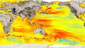
Scientists are gathering in the Azores this week to share findings on how satellite has revealed changes in the height of the sea, ice, inland bodies of water and more. Of concern to all is the fact that global sea level has not only been rising steadily over the last 25 years, but recently it is rising at a much faster rate.
Spotlight on sea-level rise
25.9.2018 15:42 ESA Observing the EarthScientists are gathering in the Azores this week to share findings on how satellite has revealed changes in the height of the sea, ice, inland bodies of water and more. Of concern to all is the fact that global sea level has not only been rising steadily over the last 25 years, but recently it is rising at a much fast rate.
Primis pořídil leteckou kameru UltraCam Eagle M3 od Vexcelu
25.9.2018 15:31 GeoBusiness Společnost Primis oznámila, že od poloviny srpna 2018 má k dispozici nový letecký kamerový systém od firmy Vexcel, konkrétně je to UltraCam Eagle Mark ... Přečíst2018 Interdrone Conference
25.9.2018 15:10 Bentley SystemsPress Coverage
GISCafe, USA
Read the articleHandle Large Files Faster and Better With Carlson Civil/Hydrology/GIS 2019
25.9.2018 15:09 Carlson Software MAYSVILLE, Kentucky, U.S.A. (September 2018) — Enhancements to the 3D Viewer routine, triangulation file utilities, and parking lot design abilities are just some of the newest features in the just released Carlson Civil 2019. “The 3D Viewer routines have all been overhauled in Carlson Civil 2019,” says David Carlson, Carlson Software V.P. of Development. “That […]Siemens and Bentley Partner in New Digital Solution to Optimize Capital Project Delivery
25.9.2018 15:07 Bentley SystemsPress Coverage
EPC World, India
Read the articleElectrical CAD: The new ‘it’ of Indian EE industry
25.9.2018 15:04 Bentley SystemsPress Coverage
Electrical & Power Review, India
Read the article2018 GSA Open Days. Mark your calendar
25.9.2018 15:00 European GNSS Agency
On Friday, November 16th and Saturday 17th, the GSA Headquarters in Prague will be open to the public for the 4th year in a row.
This is a unique opportunity to get an insider’s look at the European GNSS (Global Navigation Satellite System) services and the people behind them.
Part of the Czech Space Week 2018 activities, this year’s GSA Open Days will give you a chance to experience the journey of Galileo satellites from the rocket launch in Kourou, French Guiana, to the services used by citizens and business worldwide. This is your opportunity to learn more about what the European Union is doing in space and satellite navigation; the crucial role of the GSA and the impact satellite navigation has in our daily lives.
The programme includes exciting seminars and space workshops, competitions and quizzes, programmes for school visits, and other fun educational activities!
Come visit us and see and follow Galileo satellites, take a selfie in space, try landing a plane with EGNOS or experience a Search and Rescue with the help of Galileo, and win great prizes!
The draft programme can be found here.
If you would like to visit us as a school, please fill in the registration form.
Follow @EU_GNSS for regular Open Days updates on Twitter.
Use the hashtag #GSAOpenDays to share your experience of this year’s Open Days.
Media note: This feature can be republished without charge provided the European GNSS Agency (GSA) is acknowledged as the source at the top or the bottom of the story. You must request permission before you use any of the photographs on the site. If you republish, we would be grateful if you could link back to the GSA website (http://www.gsa.europa.eu).
20180925 vrchní referent/rada - obnova katastrálního operátu
25.9.2018 14:47 ČÚZK - předpisy a opatření Katastrální úřad pro Středočeský kraj zveřejnil novou aktualitu: vrchní referent/rada - obnova katastrálního operátu V části "Úřední deska", v sekci "Oznámení a jiná úřední sdělení" bylo vystaveno "Oznámení o vyhlášení výběrového řízení na obsazení systemizovaného místa vrchní referent/rada - obnova katastrálního operátu"20180925 vrchní referent/rada - obnova katastrálního operátu
25.9.2018 14:47 ČÚZK /Urady/Katastralni-urady/Katastralni-urady/Katastralni-urad-pro-Stredocesky-kraj/O-uradu/Aktuality/20180829-Odborny-referent-oddeleni-dokumentace-(1)vrchní referent/rada - obnova katastrálního operátu
25.9.2018 14:46 ČÚZK - předpisy a opatření Katastrální úřad pro Středočeský kraj - technická sekcevypisuje výběrové řízení na místo vrchní referent/rada - obnova katastrálního operátu
vrchní referent/rada - obnova katastrálního operátu
vrchní referent/rada - obnova katastrálního operátu
25.9.2018 14:46 ČÚZK /Urady/Katastralni-urady/Katastralni-urady/Katastralni-urad-pro-Stredocesky-kraj/Volna-mista/vrchni-referent-rada-obnova-katastralniho-operatvrchní referent/rada - obnova katastrálního operátu
25.9.2018 14:46 ČÚZK - volná místa Katastrální úřad pro Středočeský kraj - technická sekce vypisuje výběrové řízení na místo vrchní referent/rada - obnova katastrálního operátuPoslední aktualizace před verzí 14
25.9.2018 14:30 GEPROZveřejnili jsme verze 13.73 našich produktů MISYS, MISYS-WEB, KOKEŠ a PROLAND.
Stahovat je můžete z obvyklého umístění na našem download serveru:
… >>Poslední aktualizace před verzí 14
25.9.2018 14:30 GEPROZveřejnili jsme verze 13.73 našich produktů MISYS, MISYS-WEB, KOKEŠ a PROLAND.
Stahovat je můžete z obvyklého umístění na našem download serveru:
… >>Poslední aktualizace před verzí 14
25.9.2018 14:30 GEPROZveřejnili jsme verze 13.73 našich produktů MISYS, MISYS-WEB, KOKEŠ a PROLAND.
Stahovat je můžete z obvyklého umístění na našem download serveru:
… >>Poslední aktualizace před verzí 14
25.9.2018 14:30 GEPROZveřejnili jsme verze 13.73 našich produktů MISYS, MISYS-WEB, KOKEŠ a PROLAND.
Stahovat je můžete z obvyklého umístění na našem download serveru:
… >>Poslední aktualizace před verzí 14
25.9.2018 14:30 GEPROZveřejnili jsme verze 13.73 našich produktů MISYS, MISYS-WEB, KOKEŠ a PROLAND.
Stahovat je můžete z obvyklého umístění na našem download serveru:
… >>Poslední aktualizace před verzí 14
25.9.2018 14:30 GEPROZveřejnili jsme verze 13.73 našich produktů MISYS, MISYS-WEB, KOKEŠ a PROLAND.
Stahovat je můžete z obvyklého umístění na našem download serveru:
… >>Juniper Systems releases new Cedar CP3 Rugged Smartphone
25.9.2018 14:08 GISCafe.com Webcasts-Webinars Sept. 24, 2018, LOGAN, UT – Juniper Systems announced today the release of its newest Cedar device, the Cedar CP3 Rugged …Orbit GT opens Australian Data Center to boost Global Performance for 3D Mapping Cloud SaaS platform
25.9.2018 14:02 GISCafe.com Webcasts-Webinars Lokeren, September 25th, 2018 -- Orbit GT opens new Australian Data Center to boost global performance for 3D Mapping Cloud SaaS …O čem bude letošní Konference GIS Esri v ČR?
25.9.2018 14:00 ARCDATAKonference opět nabídne přednášky o technologii, odborné workshopy a minisemináře ARCDATA, stejně jako bloky uživatelských přednášek zaměřující se na aktuální témata z veřejné správy, dálkového průzkumu Země, správy inženýrských sítí či managementu životního prostředí.
Podívejte se na stránky konference, kde naleznete přehled přednášek a jejich abstrakty. Nezapomeňte také, že přihlášku do soutěže posterů či na přehlídku internetových aplikací je třeba zaslat do 12. října.

European Space Imaging Awarded €20 Million Maritime Contract
25.9.2018 13:51 GISCafe.com Webcasts-Webinars Munich, 24/09/18 -- European Space Imaging has been awarded its third major contract for the provision of very high resolution optical satellite …Výpadek telefonní sítě
25.9.2018 12:40 ČÚZK - předpisy a opatření Katastrální úřad pro Středočeský kraj - Katastrální pracoviště Kladno zveřejnil novou aktualitu:Vážení,
O2 nám oznámilo nutný plánovaný výpadek telefonní sítě na dobu 2 hodin v době od 08.00 hod. do 16.00 hod. ve čtvrtek 27. 9. 2018. Přijměte, prosím, naši omluvu za případné komplikace, které Vám plánovaný výpadek služeb může způsobit.
Výpadek telefonní sítě
25.9.2018 12:40 ČÚZK /Urady/Katastralni-urady/Katastralni-urady/Katastralni-urad-pro-Stredocesky-kraj/Katastralni-pracoviste/KP-Kladno/O-uradu/Aktuality/Vypadek-telefonni-siteGeotrain Cup 2018
25.9.2018 12:31 HrdličkaLetošní 4. ročník se konal opět v pohodové náladě, počasí turnaji přálo a všichni si mohli užít příjemné setkání na golfovém hřišti. Magické datum turnaje přineslo některým hráčům naopak štěstí a bylo dosaženo výjimečných výsledků. Z celkového počtu 59 účastníků golfového turnaje si 25 hráčů zlepšilo svůj HCP. Za zmínku bezesporu stojí zlepšení vítěze skupiny HCP 22,1... View Article
The post Geotrain Cup 2018 appeared first on HRDLIČKA spol. s r.o. - komplexní služby v oblasti geodézie.
Satellites safeguard Europe’s potato industry
25.9.2018 12:15 ESA Observing the Earth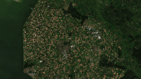
The drought that swept through Europe this year has hit European farmers hard. Sustained high temperatures and the lack of rain have badly affected the agrofood industry, including the important potato sector.
Vzdělávací kurz pro vývojáře Nanodružic – Cubesatů, registrace do 28.9.2018!
25.9.2018 11:26 Český Kosmický PortálIndická kosmická agentura (ISRO) spustila v rámci UNISPACE+50 iniciativy vzdělávací program UNNATI, zaměřený na vývoj nanodružic. Program je určen pro inženýry, vědecké absolventy a PhD. studenty se zájmem o vývoj družicových technologií. Jedná se o 8 týdenní program, jehož první ročník startuje v lednu 2019 s tím, že ISRO bude hradit účastníkům kompletní náklady spojené s účastí na vzdělávacím programu (letenka, ubytování, strana, místní doprava atd.). ČR má do tohoto programu možnost nominovat 2 kandidáty.
Případová studie řešení IS-PD vedení pro společnost ČEPS
25.9.2018 10:42 HrdličkaObecný popis projektu IS-PD (Informační systém provozní dokumentace vedení) Společnost ČEPS investovala v posledních letech nemalé prostředky do tvorby a oprav dat provozní dokumentace vedení s cílem mít úplnou a aktuální dokumentaci ke všem částem přenosové soustavy. Rozsah a formu provozní dokumentace určuje interní technická norma TN/45, která rozděluje dokumentaci na 3 základní části. Technická... View Article
The post Případová studie řešení IS-PD vedení pro společnost ČEPS appeared first on HRDLIČKA spol. s r.o. - komplexní služby v oblasti geodézie.
Rheinebrücke Schierstein
25.9.2018 10:15 GEFOS GEFOS a.s. se bude podílet na montáži ocelové konstrukce 1280 m dlouhého dálničního mostu Rheinebrücke Schierstein (SRN). Montáž ocelové konstrukce budou provádět Hutní montáže, a.s.Isarbrücke Plattling
25.9.2018 9:55 GEFOS GEFOS a.s. se podílí na montáži ocelové konstrukce 180 m dlouhého silničního mostu Isarbrücke Plattling (SRN). Montáž ocelové konstrukce budou provádět Hutní montáže, a.s.Nový certifikát pro komunikaci s DP a WSDP
25.9.2018 9:50 ČÚZK - předpisy a opatření Vážení uživatelé,oznamujeme, že dne 5.10.2018 bude instalován nový certifikát pro HTTPS komunikaci s WSDP. Tento certifikát bude založen na jiné root CA s názvem Certifikát DigiCert Global Root G2, SN 03 3a f1 e6 a7 11 a9 a0 bb 28 64 b1 1d 09 fa e5. Tento certifikát je možné si stáhnout na stránkách certifikační autority GeoTrust, včetně znázornění hierarchie.
Děkujeme za pochopení.
Nový certifikát pro komunikaci s DP a WSDP
25.9.2018 9:50 ČÚZK /Aplikace-DP-do-KN/Aplikace-DP-do-KN/Archiv-DP/233255Nový certifikát pro komunikaci s DP a WSDP
25.9.2018 9:50 Dálkový přístup k údajům KN ČR Vážení uživatelé,oznamujeme, že dne 5.10.2018 bude instalován nový certifikát pro HTTPS komunikaci s WSDP. Tento certifikát bude založen na jiné root CA s názvem Certifikát DigiCert Global Root G2, SN 03 3a f1 e6 a7 11 a9 a0 bb 28 64 b1 1d 09 fa e5. Tento certifikát je možné si stáhnout na stránkách certifikační autority GeoTrust, včetně znázornění hierarchie.
Děkujeme za pochopení.
Předkolo výběrového řízení INTER-19, tj. freemovers na LS 2018/2019
25.9.2018 9:31 Blogující geomatici - FAV ZČU Bylo vyhlášeno předkolo výběrového řízení INTER-19, tj. freemovers na LS 2018/2019. Pokud se budete chtít tohoto VŘ zúčastnit, obraťte se na mne do 8. 10. 2018.Dodatečné výběrové řízení Erasmus+ 2018/19 - LS
25.9.2018 9:29 Blogující geomatici - FAV ZČU Bylo vyhlášeno dodatečné výběrové řízení Erasmus+ pouze pro letní semestr 2018/19. Uvažujete-li se zúčastnit tohoto VŘ dejte mi prosím vědět do 8. 10. 2018.Vyhlášení výběrového řízení na referenta odboru územního plánování Městského úřadu Nýřany
25.9.2018 9:25 Blogující geomatici - FAV ZČU Bylo vyhlášeno výběrové řízení na referenta odboru územního plánování Městského úřadu Nýřany, pracoviště Plzeň se smlouvou na dobu neurčitou. Je možné se do tohoto VŘ přihlásit až do 5. 10. 2018. Více informací v následujícím odkazu:http://www.nyrany.cz/e_download.php?file=data/uredni_deska/obsah1764_86.pdf&original=602ML2018.pdf
D11 1107 Smiřice – Jaroměř
25.9.2018 9:17 GEFOS GEFOS a.s. provádí geodetické práce pro zhotovitele stavby, sdružení firem Porr a.s. a Porr Bau GmbH, s.r.o. Parametry stavby: délka úseku: 7150 m, cena stavby dle SOD: 1 497 742 032 Kč bez DPH, termín výstavby: 05/2018 – 12/2021.Interview with Michael Pehel, Marketing Manager at InterDrone 2018
25.9.2018 9:00 GISCafe.com Webcasts-WebinarsOtevírací doba v zimním semestru [Knihovna geografie, byTopic]
25.9.2018 8:55 Katedra aplikované geoinformatiky a kartografie Přf UK Změna otevírací doby od 1. října 2018.vrchní referent/rada – návrh zápisu v katastru
25.9.2018 8:52 ČÚZK - předpisy a opatření Katastrální úřad pro Olomoucký kraj - Katastrální pracoviště Olomoucvypisuje výběrové řízení na místo
vrchní referent/rada – návrh zápisu v katastru
vrchní referent/rada – návrh zápisu v katastru
25.9.2018 8:52 ČÚZK /Urady/Katastralni-urady/Katastralni-urady/Katastralni-urad-pro-Olomoucky-kraj/Uredni-deska/Oznameni-a-jina-uredni-sdeleni/Volna-mista/vrchni-referent-rada-–-navrh-zapisu-v-katastruvrchní referent/rada – návrh zápisu v katastru
25.9.2018 8:52 ČÚZK - volná místa Katastrální úřad pro Olomoucký kraj - Katastrální pracoviště Olomouc vypisuje výběrové řízení na místo vrchní referent/rada – návrh zápisu v katastruFrýdek-Místek, obchvat
25.9.2018 8:39 GEFOS GEFOS a.s. bude na výstavbě obchvatu Frýdku-Místku provádět geodetické práce pro zhotovitele stavby, sdružení firem ALPINE Bau CZ a.s., HABAU CZ s.r.o., BERGER BOHEMIA a. s. Akce je stavebně členěna na 2 části: „D48 Frýdek-Místek, obchvat – I. etapa“ v délce 4250 m, „D56 Frýdek-Místek – připojení na D48“ v délce 2300 m. Cena stavby dle smlouvy: […]Oznámení o vyhlášení výběrového řízení na služební místo Katastrálního pracoviště Chrudim
25.9.2018 8:06 ČÚZK - předpisy a opatření Katastrální úřad pro Pardubický kraj - Katastrální pracoviště Chrudimvypisuje výběrového řízení na služební místo Katastrálního pracoviště Chrudim - odborný referent
Oznámení o vyhlášení výběrového řízení na služební místo Katastrálního pracoviště Chrudim
Oznámení o vyhlášení výběrového řízení na služební místo Katastrálního pracoviště Chrudim
25.9.2018 8:06 ČÚZK /Urady/Katastralni-urady/Katastralni-urady/Katastralni-urad-pro-Pardubicky-kraj/Uredni-deska/Oznameni-a-jina-uredni-sdeleni/Volna-mista/Oznameni-o-vyhlaseni-vyberoveho-rizeni-na-sluzebniOznámení o vyhlášení výběrového řízení na služební místo Katastrálního pracoviště Chrudim
25.9.2018 8:06 ČÚZK - volná místa Katastrální úřad pro Pardubický kraj - Katastrální pracoviště Chrudim vypisuje výběrové řízení na místo Oznámení o vyhlášení výběrového řízení na služební místo Katastrálního pracoviště ChrudimCrowdsourcing poprvé aneb jak na precizní sledování krav
25.9.2018 6:49 GISportal.cz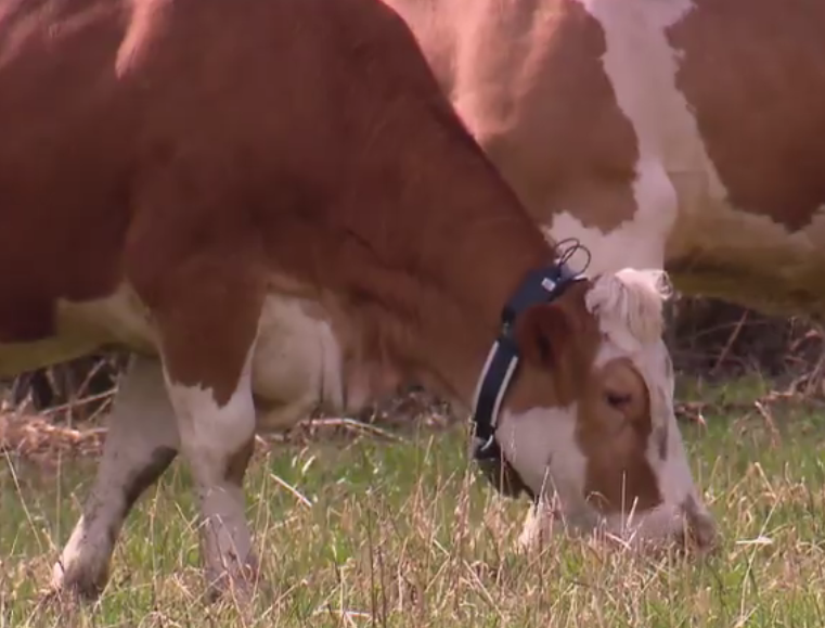
Tento čtyřdílný miniseriál přináší přehlídku „crowdsourcing“ aplikací tzv. vizuální analytiky od mapování kriminality, přes krizové řízení až po precizní zemědělství. Jejich pojítky jsou česká stopa v mezinárodním poli geoinformatiky, ale také snaha o vyhodnocení větších objemů dat. Začínat terminologií se stalo akademickou tradicí. Ani tento článek není výjimkou. Jaké jsou rozdíly mezi pojmy volunteer geographic information, […]
The post Crowdsourcing poprvé aneb jak na precizní sledování krav appeared first on GISportal.cz.
MĚŘENÍ V PRŮMYSLU - doprovodný odborný program mezinárodního strojírenského veletrhu v Brně
25.9.2018 6:07 Zeměměřič Český svaz geodetů a kartografů a mediální partner akce časopis zeměměřič vás zvou na odbornou akci MĚŘENÍ V PRŮMYSLU, která se bude konat ve čtvrtek4. října 2018 v Brně.
Přírodní biotopy (aktualizace základního mapování biotopů)
25.9.2018 2:00 Cenia - Katalog metadat ČR - INSPIRE Hranice segmentů přírodních biotopů a relační databáze jejich charakteristik z aktualizace základního mapování biotopů; klasifikace biotopů viz CHYTRÝ, M.; KUČERA, T.; KOČÍ, M. (eds.) et al. (2010). Katalog biotopů České republiky. 2.upr. a rozš.vyd. Praha: Agentura ochrany přírody a krajiny ČR. 445 s. ISBN 978-80-87457-03-0.; popis charakteristik biotopů a segmentů viz platná metodika mapování biotopů (Portál ISOP/Mapování biotopů); vrstva obsahuje jednoduché prvky (Singlepart Features), kardinalita vztahu mezi záznamy v tabulkách 1 : N; © AOPK ČR, 2018Data z mapování biotopů neposkytují vyčerpávající informaci o vegetaci, resp. biotopech daného území. Mapování biotopů je opakováno v pravidelných cyklech (frekvence cyklů aktualizace je plánována jako 12letá), především efemérní biotopy mohou být pominuty. Je metodicky nastaveno na celostátní úrovni, v lokálním měřítku je pouze zjednodušeným podkladem. Pro detailnější informaci je třeba odborný průzkum či konzultace.Přírodní biotopy (základní mapování biotopů)
25.9.2018 2:00 Cenia - Katalog metadat ČR - INSPIRE Hranice segmentů přírodních biotopů a relační databáze jejich charakteristik ze základního mapování biotopů; klasifikace biotopů viz CHYTRÝ, M.; KUČERA, T.; KOČÍ, M. (eds.) (2001). Katalog biotopů České republiky: Interpretační příručka k evropským programům Natura 2000 a Smaragd. Vyd. 1. Praha: Agentura ochrany přírody a krajiny ČR. 307 s. ISBN 80-86064-55-7.; popis charakteristik biotopů a segmentů viz Guth, J. (ed.), 2002: Metodiky mapování biotopů soustavy Natura 2000 a Smaragd. 3. přepracované vydání. Ms., AOPK ČR, Praha, 48 pp. vrstva obsahuje jednoduché prvky (Singlepart Features), kardinalita vztahu mezi záznamy v tabulkách 1 : N; © AOPK ČR, 2006Data z mapování biotopů neposkytují vyčerpávající informaci o vegetaci, resp. biotopech daného území. Mapování biotopů je opakováno v pravidelných cyklech (frekvence cyklů aktualizace je plánována jako 12letá), především efemérní biotopy mohou být pominuty. Je metodicky nastaveno na celostátní úrovni, v lokálním měřítku je pouze zjednodušeným podkladem. Pro detailnější informaci je třeba odborný průzkum či konzultace.Habitaty (základní mapování biotopů)
25.9.2018 2:00 Cenia - Katalog metadat ČR - INSPIRE Hranice segmentů habitatů a relační databáze jejich charakteristik ze základního mapování biotopů; převodní tabulka habitatů viz CHYTRÝ, M.; KUČERA, T.; KOČÍ, M. (eds.) (2001). Katalog biotopů České republiky: Interpretační příručka k evropským programům Natura 2000 a Smaragd. Vyd. 1. Praha: Agentura ochrany přírody a krajiny ČR. 307 s. ISBN 80-86064-55-7.; vrstva obsahuje jednoduché prvky (Singlepart Features), kardinalita vztahu mezi záznamy v tabulkách 1 : N; © AOPK ČR, 2006Data z mapování biotopů neposkytují vyčerpávající informaci o vegetaci, resp. biotopech daného území. Mapování biotopů je opakováno v pravidelných cyklech (frekvence cyklů aktualizace je plánována jako 12letá), především efemérní biotopy mohou být pominuty. Je metodicky nastaveno na celostátní úrovni, v lokálním měřítku je pouze zjednodušeným podkladem. Pro detailnější informaci je třeba odborný průzkum či konzultace.Habitaty (aktualizace základního mapování biotopů)
25.9.2018 2:00 Cenia - Katalog metadat ČR - INSPIRE Hranice segmentů habitatů a relační databáze jejich charakteristik z aktualizace základního mapování biotopů; převodní tabulka habitatů viz CHYTRÝ, M.; KUČERA, T.; KOČÍ, M. (eds.) et al. (2010). Katalog biotopů České republiky. 2.upr. a rozš.vyd. Praha: Agentura ochrany přírody a krajiny ČR. 445 s. ISBN 978-80-87457-03-0.; vrstva obsahuje jednoduché prvky (Singlepart Features), kardinalita vztahu mezi záznamy v tabulkách 1 : N; © AOPK ČR, 2018Data z mapování biotopů neposkytují vyčerpávající informaci o vegetaci, resp. biotopech daného území. Mapování biotopů je opakováno v pravidelných cyklech (frekvence cyklů aktualizace je plánována jako 12letá), především efemérní biotopy mohou být pominuty. Je metodicky nastaveno na celostátní úrovni, v lokálním měřítku je pouze zjednodušeným podkladem. Pro detailnější informaci je třeba odborný průzkum či konzultace.Fortem Technologies Launches Portable SkyDome For Airspace Awareness, Safety and Security
24.9.2018 22:44 GISCafe.com Webcasts-Webinars Fortem SkyDome Awarded Most Innovative Product by Global Security ExchangeSALT LAKE CITY, Sept. 24, 2018 — (PRNewswire) — Fortem …
MAPSearch Launches New Algorithm to Simplify Solar Site Selection
24.9.2018 22:44 GISCafe.com Webcasts-Webinars ENvision, the next generation of energy mapping technology, introduces a new tool specifically designed to help solar developers with site …Airbus announces finalists of Multi-Data Challenge within Copernicus Masters 2018
24.9.2018 21:09 GISCafe.com Webcasts-Webinars Toulouse, 24 September 2018 – Airbus Defence and Space announced today the names of the three finalists of the Airbus Multi-Data Challenge …USGIF Releases Report on Geospatial Intelligence & Community Resilience
24.9.2018 20:56 GISCafe.com Webcasts-Webinars Learn how and why local, state, and federal governments should employ geospatial intelligence to prepare for increasing threats posed by natural …Monitorovali jsme demolici šedesáti metrového komínu v bývalé ostrovské Škodovce
24.9.2018 20:53 UpVision Minulý týden jsme monitorovali demolici šedesáti metrového komínu hydraulickými nůžkami v bývalé ostrovské Škodovce.Několik fotografií zde:
https://plus.google.com/u/0/b/115833877689730865211/+UpvisionCz1/posts/gDRYm4dn1bx
Více o areálu zde:
https://www.e15.cz/byznys/reality-a-stavebnictvi/ostrovske-rodiste-trolejbusu-mizi-panattoni-do-prestavby-arealu-nalije-miliardu-1351414
Are You Overlooking a Significant Source of Savings?
24.9.2018 19:26 Bentley SystemsPress Coverage
Oil & Gas Australia, Australia/New Zealand
Read the articleTech firms integrate platform to enable digital twins
24.9.2018 19:17 Bentley SystemsPress Coverage
MEED, Middle East
Read the articleUnderstanding to use water assets effectively
24.9.2018 19:12 Bentley SystemsPress Coverage
Technical Review Middle East, Middle East
Read the articleInternational Infrastructure Award Finalists Announced
24.9.2018 19:08 Bentley SystemsPress Coverage
Position IT, Sub Sahara Africa
Read the articleNew BlueSky GNSS Firewall From Microsemi Provides Secure, Continuous Timing Integrity in GPS-Denied Environments
24.9.2018 17:21 GISCafe.com Webcasts-Webinars Showcasing at ION GNSS+ in Booth 612, Security-Hardened System Provides Resilience for Over 30 Days Without Live Sky AccessALISO VIEJO, Calif., …
Integrated Navigation Systems by Polynesian Exploration Inc.
24.9.2018 17:21 GISCafe.com Webcasts-Webinars SAN JOSE, Calif. — (BUSINESS WIRE) — September 24, 2018 —Polynesian Exploration Inc. introduced today PolyNav 2000P, a high …
Maxar Technologies' DigitalGlobe Selected to Create a Geospatial Cloud Analytics Hub for DARPA
24.9.2018 17:21 GISCafe.com Webcasts-Webinars WESTMINSTER, CO, Sept. 24, 2018 — (PRNewswire) — DigitalGlobe, a Maxar Technologies company (formerly MacDonald, Dettwiler and …Sparx Systems Supports Standards Development for Intelligent Transport Systems (ITS)
24.9.2018 17:21 GISCafe.com Webcasts-Webinars ISO/TC 204 and CEN/TC 278 standards developers deploy Enterprise ArchitectCRESWICK, Australia, Sept. 24, 2018 — (PRNewswire) — …
Nearmap Aerial Imagery Now Available for Areas Impacted by Hurricane Florence
24.9.2018 17:21 GISCafe.com Webcasts-Webinars Newly captured aerial maps show before and after images to supportcleanup efforts by public safety organizations, utility companies and
…
Altimetry replay
24.9.2018 16:43 ESA Observing the Earth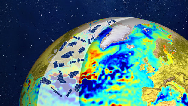
World-class scientists are meeting in the Azores to discuss the latest findings on sea-level rise, ice melt and more – all based on satellite altimeters. Watch the opening session replay
Urban planning app takes top prize at Space App Camp
24.9.2018 16:30 ESA Observing the Earth
An app that uses satellite imagery to assist urban planners scooped the top prize of €2500 at this year’s Space App Camp at ESA’s Earth observation centre in Frascati, Italy.
ÚČOV
24.9.2018 15:57 GEFOS Na pražském Císařském ostrově začala 19.9.2018 fungovat ve zkušebním provozu nová vodní linka Ústřední čistírny odpadních vod (ÚČOV). Stavba za 6,2 mld. Kč bez DPH probíhala 3 roky. GEFOS a.s. zde prováděl geodetické práce pro sdružení firem SMP CZ, Hochtief CZ, Degremont a WTE Wassertechnik.Negrelliho viadukt
24.9.2018 15:14 GEFOS Rekonstrukce Negrelliho viaduktu vstoupila do druhé třetiny. GEFOS a.s. se podílí na rekonstrukci tohoto nejdelšího mostu v Praze (1110 m), který spojuje Masarykovo nádraží přes ostrov Štvanici s Bubny. Generálním dodavatelem je sdružení firem Hochtief – Strabag Rail – Avers. Cena rekonstrukce činí cca 1,3 mld. Kč.Výzkumné sondy mise BepiColombo byly před startem spojeny
24.9.2018 14:41 Český Kosmický PortálDvojice vědeckých sond tvořících společnou misi ESA a JAXA BepiColombo je nyní spojena do startovní konfigurace. Evropská sonda plus dopravní modul pak dostaly souhlas s tankováním pohonnými látkami.
Výzkumné sondy mise BepiColombo byly před startem spojeny
24.9.2018 14:41 Český Kosmický PortálDvojice vědeckých sond tvořících společnou misi ESA a JAXA BepiColombo je nyní spojena do startovní konfigurace. Evropská sonda plus dopravní modul pak dostaly souhlas s tankováním pohonnými látkami.
Brno nově eviduje cyklistická opatření v celém regionu
24.9.2018 14:10 T-MAPYThe post Brno nově eviduje cyklistická opatření v celém regionu appeared first on T-MAPY spol. s r.o..
European students and researchers: compete in our new Galileo app competition
24.9.2018 13:11 ESA Navigation
Students and research trainees across Europe are invited to take part in ESA’s new Galileo smartphone app competition – to develop an app capable of performing fixes using raw Galileo satnav measurements.
Run by ESA in collaboration with the European Global Navigation Satellite Systems Agency – GSA – plus the European Commission with the support of Google, this Galileo app competition is open to all students from European universities and trainees in posts at European research and development organisations.
Modernizace D1
24.9.2018 12:18 GEFOS Do provozu se uvádějí úseky 10 a 04 modernizované D1 – na obou se podílel GEFOS a.s. 14.9.2018 byl uveden do provozu úsek 10 (EXIT 75 Hořice – EXIT 81 Koberovice) modernizované dálnice D1, kde pro zhotovitele stavby, sdružení EUROVIA, COLAS, EUROVIA Beton, zajišťoval geodetické práce GEFOS a.s. Parametry stavby: délka úseku – 6497 m, cena […]GNSS User Technology Report 2018 available for download now!
24.9.2018 12:16 European GNSS Agency
The second edition of the GSA’s GNSS User Technology Report has been published and is now available for free download, providing an exhaustive review of all the latest GNSS trends and developments. Since its launch in 2016, the GNSS User Technology Report has become the go-to-source for information on the dynamic, global GNSS technology industry.
The GNSS User Technology Report, a sister publication to the GSA’s GNSS Market Report, is published every two years and takes an in-depth look at the latest state-of-the-art GNSS receiver technology, along with providing expert analysis on the trends that will shape the global GNSS landscape in the coming years.
Like the inaugural Report in 2016, the second issue focuses on three key macrosegments: mass market solutions; transport safety- and liability-critical solutions; and high precision, timing and asset management solutions. The report opens with an overview of the latest developments and trends in GNSS, with a focus on the multi-constellation and multi-frequency that are driving new trends in the sector.
Important new trend
“With the GNSS User Technology Report, our aim is to provide everybody in the GNSS value chain with a comprehensive overview of the current landscape in the industry and to identify new trends so that stakeholders know in which direction the industry is moving,” GSA Executive Director Carlo des Dorides said, adding: “The most important new trend identified in this issue is the rapid adoption of multiple frequencies, including for consumer devices, as evidenced by the market introduction of the first dual-frequency smartphone in May 2018”.
Read this: GNSS Market Report proves a useful tool across the GNSS market
Some highlights from this year’s report
|
Editor’s special
The final section in this year’s report – the ‘Editor’s special’ section - is dedicated to automation and to the increasingly important role GNSS plays in a number of partially- or fully-automated tasks and functions.
“The most important examples of ambient intelligence and automation are found in the transport domain - driverless cars, autonomous vessels and drones,” says Martin Sunkevic, Market Development Innovation Officer at the GSA in charge of technology monitoring. “It is however important to note that GNSS-based automation applications go well beyond transport. In the report we present examples from all segments.”
“Automation requires secure, ubiquitous and accurate location information for positioning.” said Jean-Pierre Barboux, Project Manager from FDC, which was part of the technology research team at the GSA. “Only thanks to the new generation of positioning systems and omnipresent connectivity we can see this rapid growth of partially and fully automated solutions.”
The analysis of GNSS user technology trends in the Report is supported by testimonials from key suppliers of receiver technology, including: Broadcom, Javad, Kongsberg, Leica, Maxim Integrated, Meinberg, NovAtel, Orolia-Spectracom, Qualcomm, Septentrio, STMicroelectronics, Thales, Trimble and u-blox. In addition, the report includes highlights from around 20 ongoing research projects from the Horizon 2020 and Fundamental Elements programmes aiming at the development of GNSS receiver technology.
The full GNSS User Technology Report 2018 is available for download here.
Media note: This feature can be republished without charge provided the European GNSS Agency (GSA) is acknowledged as the source at the top or the bottom of the story. You must request permission before you use any of the photographs on the site. If you republish, we would be grateful if you could link back to the GSA website (http://www.gsa.europa.eu).
Rising seas
24.9.2018 11:50 ESA Observing the Earth
Information from satellites not only shows that our seas are rising, but that the rate of rise is accelerating
Tour de GEFOS 2018
24.9.2018 9:35 GEFOS Utužování kolektivu není nikdy dost. Ve dnech 14. a 15. 9. proběhl 1. ročník firemní akce „Tour de GEFOS“. Počasí se naštěstí umoudřilo a tak peloton absolvoval pátečních 43 km i sobotních 78 km na okruhu po Praze a okolí s úsměvem na rtech (většinou).Interview with Jillian Switzer, Director of Marketing at AirMap at InterDrone 2018
24.9.2018 9:00 GISCafe.com Webcasts-WebinarsKde se vyrábí nejvíce čisté energie?
24.9.2018 8:57 GISportal.cz
Na tuto otázku se snaží odpovědět webová mapová aplikace electricityMap Live. Mapa zobrazuje jednotlivé státy nebo jejich části podle množství oxidu uhličitého v gramech vyprodukovaného za účelem výroby jedné kWh elektrické energie. U oblastí lze také zjistit podíl energie vyrobené v nízkoemisních elektrárnách a z obnovitelných zdrojů. Mapa hodnoty vykresluje podle aktuálních dat a je […]
The post Kde se vyrábí nejvíce čisté energie? appeared first on GISportal.cz.