


![]()

zprávy
zdroje zpráv:Historická ortofotomapa Norska
18.9.2018 13:17 TopGis Letos jsme v rámci zahraničních projektů vytvořili pro Norskou Státní Mapovací Agenturu historickou ortofotomapu z archivních snímků Norských provincií Buskerund a Ostfold v blízkosti hlavního města Osla. Zpracovávali jsme snímky z různých kamer pořízené na filmový materiál, z nichž nejstarší byly pořízeny již v roce 1947. Celkem jsme během 2 měsíců zpracovali 14 074 leteckých měřických snímků. Největší výzvou proDružice Sentinel programu GMES/Copernicus mapují záplavy způsobené hurikánem Florence
18.9.2018 10:56 Český Kosmický PortálV pátek 14. září zasáhl pobřeží americké Severní Karolíny hurikán Florence, který rozsévá zkázu a vyvolává všudypřítomné záplavy. Evropské radarové družice systému GMES/Copernicus Sentinel-1 přitom již začaly mapovat zasažené oblasti.
Nová aplikace pro cestující veřejnost v Olomouckém kraji
18.9.2018 10:35 T-MAPYThe post Nová aplikace pro cestující veřejnost v Olomouckém kraji appeared first on T-MAPY spol. s r.o..
Nedostupné telefony
18.9.2018 9:28 ČÚZK - předpisy a opatření Katastrální úřad pro Moravskoslezský kraj - Katastrální pracoviště Bruntálzveřejnil novou aktualitu: Z důvodu výměny telefonní ústředny mohou být dnes 18.9.2018 telefonní kontakty Katastrálního pracoviště Bruntál nedostupné.
Nedostupné telefony
18.9.2018 9:28 ČÚZK /Urady/Katastralni-urady/Katastralni-urady/Katastralni-urad-pro-Moravskoslezsky-kraj/Katastralni-pracoviste/KP-Bruntal/O-uradu/Aktuality/Nedostupne-telefonyInterview with Benoit Fredericque, Director of Product Management at Bentley Systems at InterDrone 2018
18.9.2018 9:00 GISCafe.com Webcasts-Webinars“Žijúca mapa” – vizualizácia zrážkových úhrnov na príklade rastlín machu
18.9.2018 8:30 GISportal.cz
Téma zmeny klímy je v dnešnej dobe aktuálna. Čoraz častejšie sa stretávame s extrémnymi udalosťami spojenými napr. s výkyvmi počasia (vysoké teploty, intenzívne dažde, extrémne silné vetry a pod.), ktoré majú dopad aj na životy ľudí. Na uvedené sa snaží poukázať aj tzv. “Žijúca mapa” (LIVING MAP), ktorá na príklade rastlín machu zobrazuje zmenu zrážok v letnom období v Európe […]
The post “Žijúca mapa” – vizualizácia zrážkových úhrnov na príklade rastlín machu appeared first on GISportal.cz.
UK radar satellite NovaSAR-1 successfully launched
17.9.2018 22:46 GISCafe.com Webcasts-Webinars NovaSAR-1 built by SSTL and equipped with an Airbus SAR radar launched from IndiaPortsmouth, 16 September 2018 – The radar imaging satellite …
Trimble Adds Galileo and BeiDou to its VRS Now Service in North America
17.9.2018 19:08 GISCafe.com Webcasts-Webinars Enhanced Positioning Integrity and Reliability for GNSS ApplicationsSUNNYVALE, Calif., Sept. 17, 2018 — (PRNewswire) — Trimble …
Siemens and Bentley Systems Strengthen Their Strategic Alliance and Joint Investment Initiatives
17.9.2018 15:05 Bentley SystemsPress Coverage
Chemical Engineering, USA
Read the articleTopcon introduces new software for UAV inspection applications
17.9.2018 14:58 Bentley SystemsPress Coverage
Global News Wire, USA
Read the articleSiemens and Bentley Systems strengthen their strategic alliance
17.9.2018 14:50 Bentley SystemsPress Coverage
GeoConnexion, UK
Read the articleSiemens Expands Digitalization Investments
17.9.2018 14:47 Bentley SystemsPress Coverage
Automation World, USA
Read the articleFirst day of camp
17.9.2018 14:44 ESA Observing the Earth
From 17-24 September, twenty app developers will be creating mobile applications using satellite data at the Space App Camp, held at ESA's site in Italy
First day of camp
17.9.2018 14:44 ESA Observing the EarthFrom 17-24 September, 24 app developers will be creating mobile applications using satellite data at the Space App Camp, held at ESA's site in Italy
20180917 - Vzorová data VF ISKN ve verzi 5.3
17.9.2018 14:30 ČÚZK - Výměnný formát ISKN Vzorová data VF ISKN ve verzi 5.3 pro testování nové webové služby ctiOS. Popis služby je uveden na stránce Webové služby dálkového přístupu na zkoušku.20180917 - Vzorová data VF ISKN ve verzi 5.3
17.9.2018 14:30 ČÚZK - Výměnný formát ISKN Vzorová data VF ISKN ve verzi 5.3 pro testování nové webové služby ctiOS. Popis služby je uveden na stránce Webové služby dálkového přístupu na zkoušku.Webové služby DP na zkoušku jsou opět dostupné
17.9.2018 14:05 Dálkový přístup k údajům KN ČR Vážení uživatelé webových služeb,oznamujeme, že webové služby dálkového přístupu na zkoušku jsou opět dostupné s těmito omezeními:
1) volání služby seznamSestav ve verzi služeb 2.7 končí na neočekávanou chybu. Na opravě se pracuje.
2) sestava Výpis z účtu neobsahuje informace o připojené sestavě (podřízená XML sestava). Na opravě se pracuje.
Služby jsou dostupné na těchto nových adresách:
Dokumentace:
https://wsdptrial.cuzk.cz/trial/dokumentace/
Např. WSDL pro číselníkové operace:
https://wsdptrial.cuzk.cz/trial/dokumentace/ws28/wsdp/ciselnik_v28.wsdl
Endpoint pro číselníkové operace:
https://wsdptrial.cuzk.cz/trial/ws/wsdp/2.8/ciselnik
Na stránce http://www.cuzk.cz/Katastr-nemovitosti/Poskytovani-udaju-z-KN/Dalkovy-pristup/Webove-sluzby-dalkoveho-pristupu.aspx je vystavena aktualizovaná dokumentace.
Webové služby DP na zkoušku jsou opět dostupné
17.9.2018 14:05 ČÚZK /Aplikace-DP-do-KN/Aplikace-DP-do-KN/Archiv-DP/232160Webové služby DP na zkoušku jsou opět dostupné
17.9.2018 14:05 ČÚZK - předpisy a opatření Vážení uživatelé webových služeb,oznamujeme, že webové služby dálkového přístupu na zkoušku jsou opět dostupné s těmito omezeními:
1) volání služby seznamSestav ve verzi služeb 2.7 končí na neočekávanou chybu. Na opravě se pracuje.
2) sestava Výpis z účtu neobsahuje informace o připojené sestavě (podřízená XML sestava). Na opravě se pracuje.
Služby jsou dostupné na těchto nových adresách:
Dokumentace:
https://wsdptrial.cuzk.cz/trial/dokumentace/
Např. WSDL pro číselníkové operace:
https://wsdptrial.cuzk.cz/trial/dokumentace/ws28/wsdp/ciselnik_v28.wsdl
Endpoint pro číselníkové operace:
https://wsdptrial.cuzk.cz/trial/ws/wsdp/2.8/ciselnik
Na stránce http://www.cuzk.cz/Katastr-nemovitosti/Poskytovani-udaju-z-KN/Dalkovy-pristup/Webove-sluzby-dalkoveho-pristupu.aspx je vystavena aktualizovaná dokumentace.
20180917 - volné místo - Odborný rada v oddělení právních vztahů na Katastrálním pracovišti Louny
17.9.2018 13:28 ČÚZK - předpisy a opatření Katastrální úřad pro Ústecký kraj - Katastrální pracoviště Louny zveřejnil novou aktualitu: Nabídka volného pracovního místa - Odborný rada v oddělení právních vztahů k nemovitostem (právník) na Katastrálním pracovišti Louny20180917 - volné místo - Odborný rada v oddělení právních vztahů na Katastrálním pracovišti Louny
17.9.2018 13:28 ČÚZK /Urady/Katastralni-urady/Katastralni-urady/Katastralni-urad-pro-Ustecky-kraj/O-uradu/Aktuality/20180917-volne-misto-Odborny-rada-v-oddeleni-pOdborný rada v oddělení právních vztahů k nemovitostem (právník) na Katastrálním pracovišti Louny
17.9.2018 13:18 ČÚZK - předpisy a opatření Katastrální úřad pro Ústecký kraj - Katastrální pracoviště Lounyvypisuje výběrové řízení na místo
Odborný rada v oddělení právních vztahů k nemovitostem (právník) na Katastrálním pracovišti Louny
Odborný rada v oddělení právních vztahů k nemovitostem (právník) na Katastrálním pracovišti Louny
17.9.2018 13:18 ČÚZK /Urady/Katastralni-urady/Katastralni-urady/Katastralni-urad-pro-Ustecky-kraj/Uredni-deska/Oznameni-a-jina-uredni-sdeleni/Volna-mista/Odborny-rada-v-oddeleni-pravnich-vztahu-k-nemovitoOdborný rada v oddělení právních vztahů k nemovitostem (právník) na Katastrálním pracovišti Louny
17.9.2018 13:18 ČÚZK - volná místa Katastrální úřad pro Ústecký kraj - Katastrální pracoviště Louny vypisuje výběrové řízení na místo Odborný rada v oddělení právních vztahů k nemovitostem (právník) na Katastrálním pracovišti LounyNedostupnost připojení
17.9.2018 12:22 ČÚZK - předpisy a opatření Katastrální úřad pro Středočeský kraj - Katastrální pracoviště Kolín zveřejnil novou aktualitu: Vážení klienti,dne 18.09.2018 od 10 do 13 hod. je kvůli pracem na tel. ústředně možnost nedostupného telefonického připojení.
Za případné komplikace se omlouváme.
Nedostupnost připojení
17.9.2018 12:22 ČÚZK - předpisy a opatření Český úřad zeměměřický a katastrální zveřejnil novou aktualitu: Vážení klienti,dne 18.09.2018 od 10 do 13 hod. je kvůli pracem na tel. ústředně možnost nedostupného telefonického připojení.
Za případné komplikace se omlouváme.
Nedostupnost připojení
17.9.2018 12:22 ČÚZK /Urady/Katastralni-urady/Katastralni-urady/Katastralni-urad-pro-Stredocesky-kraj/Katastralni-pracoviste/KP-Kolin/O-uradu/Aktuality/Nedostupnost-pripojeni20180917 - uzavření KP Rumburk z důvodu přerušení dodávky elektřiny
17.9.2018 9:56 ČÚZK - předpisy a opatření Katastrální úřad pro Ústecký kraj - Katastrální pracoviště Rumburk zveřejnil novou aktualitu:Dne 17.9.2018 bude Katastrální pracoviště Rumburk z technických důvodů uzavřeno. Důvodem je přerušení dodávky elektřiny, na nápravě se usilovně pracuje.
Omlouváme se za případné komplikace a děkujeme za pochopení.
20180917 - uzavření KP Rumburk z důvodu přerušení dodávky elektřiny
17.9.2018 9:56 ČÚZK /Urady/Katastralni-urady/Katastralni-urady/Katastralni-urad-pro-Ustecky-kraj/Katastralni-pracoviste/KP-Rumburk/O-uradu/Aktuality/20180917-uzavreni-KP-Rumburk-z-duvodu-preruseniO jihlavském GIS v časopisu ArcUser
17.9.2018 9:24 ARCDATAV letním vydání časopisu ArcUser najdete článek od GISáků z Jihlavy, ve kterém se dozvíte, jak vypadá jejich každodenní práce.
V dalších článcích pak naleznete témata jako Operations Dashboard for ArcGIS, mapy s příběhem, LiDAR nebo také možnosti vzdělávání se v Esri Academy.
Mimo to jsme pro Vás opět vybrali to nejzajímavější z celého čísla.

Interview with Christian Stallings, R&D Manager at McKim & Creed at InterDrone 2018
17.9.2018 9:00 GISCafe.com Webcasts-WebinarsSITECO announces full compatibility of Road-Scanner data with TopoDOT
17.9.2018 9:00 GISCafe.com Webcasts-Webinars 14 September 2018, Bologna, Italy - SITECO Infomatica SRL , developer of the highly flexible Road-Scanner and Pave-Scanner product family, has …Mapy bezpečnosti – společný projekt VŠB a čtyř měst
17.9.2018 8:48 GISportal.cz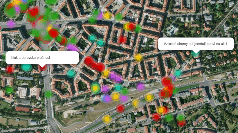
V rámci společného projektu Vysoké školy báňské – Technické univerzity Ostrava (konkrétně Katedry geoinformatiky) s čtyřmi městy – Ostrava, Olomouc, Kolín a MČ Praha 12, který financuje Technologická agentura ČR se vytváří několik pocitových map bezpečnosti. Mapy jsou dostupné na společné adrese www.mapybezpecnosti.cz. Pokud jste z těchto lokalit, budeme rádi za vyplnění mapy, popř. za sdílení odkazu na ni. […]
The post Mapy bezpečnosti – společný projekt VŠB a čtyř měst appeared first on GISportal.cz.
Startuje další ročník soutěže Žít krajinou
17.9.2018 0:00 Státní pozemkový úřad Praha, 17. září 2018 – Dne 17. září 2018 byl zahájen 12. ročník soutěže Žít krajinou, kterou pořádá Státní pozemkový úřad za účelem ocenit a představit veřejnosti nejkvalitnější realizovaná opatření navrhovaná v pozemkových úpravách. Soutěž podporuje projekty, které svým charakterem splňují požadavky na celkové řešení krajiny nebo její části.Výsledky hackathonu Hackuj stát
15.9.2018 23:38 GeoBusiness Na hackathon Hackuj stát (#hackujstat) jsme čtenáře Geobusinessu již zvali. Druhý hackathon dat veřejné správy se konal ve dnech 14. a 15. září v ... PřečístKoloběh digitálního života – pozvánka na konferenci
15.9.2018 23:10 GeoBusiness Před deseti lety vyhrávaly soutěž Křišťálová lupa projekty jako aukro.cz, Seznam E-mail, idnes.cz, Bezrealitky.cz. Od té doby se všudypřítomný internet stal nedílnou součástí našich životů. Na ... PřečístCopernicus Sentinel maps Florence hurricane flood
15.9.2018 21:40 ESA Observing the Earth
Making landfall in the US state of North Carolina on 14 September, Hurricane Florence is causing widespread damage and flooding. The Copernicus Sentinel-1 radar mission is being used to map affected areas.
39. Sympozium z dějin geodézie a kartografie - první informace
15.9.2018 7:00 Česká asociace pro geoinformace Národní technické muzeum (Kostelní 42, 170 78 Praha 7) pořádá dne 28. 11. 2018 XXXIX. Sympozium z dějin geodézie a kartografie. Přihlašovat příspěvky můžete již nyní vyplněnímInterview with David Kozlovsky, Sales Director at ParaZero at Interdrone 2018
14.9.2018 23:03 GISCafe.com Webcasts-WebinarsBe our guest at the infrastructure industry event of the year
14.9.2018 22:23 Bentley SystemsPress Coverage
GeoConnexion, UK
Read the articleSiemens and Bentley upgrade their strategic alliance after Alliance Board meeting
14.9.2018 22:16 Bentley SystemsPress Coverage
Global Manufacturing, UK
Read the articleRedefining the digital landscape of rail and transit
14.9.2018 22:12 Bentley SystemsPress Coverage
BIM Today, UK
Read the articleSiemens and Bentley Systems further strengthen alliance
14.9.2018 21:59 Bentley SystemsPress Coverage
European Pharmaceutical Manufacturer, UK
Read the articleHurricane Florence Wind and Storm Surge Could Cause Between $3 Billion and $5 Billion in Estimated Insured Property Loss, CoreLogic Analysis Shows
14.9.2018 20:35 GISCafe.com Webcasts-Webinars IRVINE, Calif. — (BUSINESS WIRE) — September 13, 2018 —CoreLogic® (NYSE: CLGX), a leading global property
…
Atlas by Hyperion: Global Blockchain-based Mapping Ecosystem Democratizes Map Making and Its Monetization
14.9.2018 20:35 GISCafe.com Webcasts-Webinars SINGAPORE, Sept. 14, 2018 — (PRNewswire) — Anyone can participate in the making of and upkeep of a map -- and make money from it. That's …New kid on the block picks up relay for ozone
14.9.2018 16:34 ESA Observing the Earth
For more than 20 years, changes in ozone over Antarctica have been carefully monitored by a succession of European satellites. This important long-term record is now being added to by the Copernicus Sentinel-5P mission, which is dedicated to atmospheric monitoring.
Letošní celosvětový Den GIS bude 14. listopadu
14.9.2018 15:48 GeoBusiness Letošní Den GIS připadá celosvětově na 14. listopadu. Také po celé České republice se na různých místech sejdou zájemci o geoinformatiku. Akce, ve světě ... Přečíst20180914 - Přihlašovací formulář na seminář RÚIAN
14.9.2018 14:56 ČÚZK - předpisy a opatření V sekci Školení 2018 je k dispozici přihlašovací formulář na seminář RÚIAN pro zaměstnance veřejné správy.20180914 - Přihlašovací formulář na seminář RÚIAN
14.9.2018 14:56 ČÚZK - předpisy a opatření V sekci Školení 2018 je k dispozici přihlašovací formulář na seminář RÚIAN pro zaměstnance veřejné správy.20180914 - Přihlašovací formulář na seminář RÚIAN
14.9.2018 14:56 ČÚZK /Uvod/Produkty-a-sluzby/RUIAN/RUIAN-novinky/2018/20180914-Prihlasovaci-formular-na-seminar-RUIANAeolus timelapse
14.9.2018 14:00 ESA Observing the Earth
A look back on preparations for the 22 August liftoff of ESA’s Aeolus wind satellite
odborný referent/vrchní referent – obnova katastrálního operátu v oddělení aktualizace KN Katastráln
14.9.2018 11:51 ČÚZK - předpisy a opatření Katastrální úřad pro Jihočeský kraj - Katastrální pracoviště Táborvypisuje výběrové řízení na místo
odborný referent/vrchní referent – obnova katastrálního operátu v oddělení aktualizace KN Katastrálního pracoviště Tábor
odborný referent/vrchní referent – obnova katastrálního operátu v oddělení aktualizace KN Katastráln
14.9.2018 11:51 ČÚZK - volná místa Katastrální úřad pro Jihočeský kraj - Katastrální pracoviště Tábor vypisuje výběrové řízení na místo odborný referent/vrchní referent – obnova katastrálního operátu v oddělení aktualizace KN Katastrálnodborný referent/vrchní referent – obnova katastrálního operátu v oddělení aktualizace KN Katastráln
14.9.2018 11:51 ČÚZK /Urady/Katastralni-urady/Katastralni-urady/Katastralni-urad-pro-Jihocesky-kraj/Volna-mista/odborny-ref-vrchni-ref-OA_KP_TAUSGIF to Host Series of Unique Geospatial Intelligence Events in St. Louis
14.9.2018 10:51 GISCafe.com Webcasts-Webinars October’s Tech Showcase West to feature unclassified and classified agendas in addition to opportunities for young professionals and …Joan Masó receives OGC’s 2018 Gardels Award
14.9.2018 10:46 GISCafe.com Webcasts-Webinars Congratulations to Joan Masó from Universitat Autònoma de Barcelona (CREAF), awarded the 2018 Gardels Award for being ‘the …Northeast Ethiopia
14.9.2018 10:05 ESA Observing the Earth
Earth observation image of the week: Sentinel-1 takes us over Semera in northeast Ethiopia
Earth from Space
14.9.2018 10:05 ESA Observing the Earth
In this week's edition, explore northeast Ethiopia with Sentinel-1
Den GIS 2018
14.9.2018 9:43 ARCDATAV listopadu se po celém světě opět uskuteční stovky akcí, které budou šířit povědomí o možnostech využití geografických informačních systémů v nejrůznějších oblastech lidské činnosti, a budeme rádi, pokud se přidáte i vy.
Ať už se rozhodnete Den GIS připravit pro svoje kolegy nebo pro veřejnost, rádi vám akci pomůžeme zpropagovat. Dejte nám o sobě proto vědět a zaregistrujte svou událost na stránkách gisday.com.
Pokud hledáte inspiraci na program, můžete využít přehledu na stránkách Dne GIS nebo se inspirovat v závěrečných zprávách loňských pořadatelů. Nahlédnout můžete také do facebookové galerie, kde naleznete fotografické střípky z předchozích ročníků.

Space-driven innovation for safer roads at ITS 2018
14.9.2018 9:24 European GNSS Agency
The European GNSS Agency (GSA) is joining with other stakeholders to present the eCall emergency response system and other innovations that leverage space technology to make Europe’s roads smarter, greener and safer, at the ITS World Congress 2018, in the Bella Centre in Copenhagen on 18 September.
Volvo is the first carmaker to announce that it is equipping its vehicles with the eCall emergency response system, which takes advantage of the precise positioning offered by the European space programmes Galileo and EGNOS to quickly alert emergency services in the event of a road accident, and automatically dial the European emergency number 112.
The eCall device in the Volvo vehicles, which uses the same location source as the in-vehicle navigation system, is manufactured by ACTIA Nordic in Sweden, is supported by the WirelessCar platform, and has been successfully tested by the NavCert eCall laboratory in Germany.
These stakeholders will join with the GSA in presenting the system at the ‘Space-driven innovation for smarter, greener and safer roads’ session at the ITS World Congress, in the Bella Centre’s Commercial Theatre at 17:00 on Tuesday, Sept 18.
Read this: eCall emergency alert system launched
Unveiling of eCall-equipped Volvo S60
A keynote address from Volvo and a panel discussion involving all the stakeholders will be followed by the unveiling of the Volvo S60, a demonstration of the car’s eCall system and an announcement for the press. This is a not-to-be-missed event for anybody interested in state-of-the-art automotive safety!
The readiness of automotive suppliers and technical services to equip vehicles with the new system was partially due to actions taken by the GSA and the European Commission’s Joint Research Centre, who launched a testing campaign and produced a joint report containing a set of guidelines to facilitate the implementation of eCall testing in compliance with the EU Regulation.
What is eCall?
eCall devices automatically dial the European emergency number 112 to alert rescue services in the event of an accident. The system sends the exact location to responders, along with the time of the incident and the direction of travel, even if the driver is unconscious or unable to make a phone call, thereby reducing the response time for road accidents and saving more lives. An eCall can also be triggered manually by pushing a button in the car, for example by a witness to a serious accident.
eCall only transmits data that is absolutely necessary when an accident occurs. Information only leaves the car in the event of a severe accident and is not stored any longer than necessary.
It is estimated that eCall will speed up emergency response times by 40% in urban areas and 50% in the countryside and reduce the number of fatalities by at least 4% and the number of severe injuries by 6%. You can find more information about eCall here.
Media note: This feature can be republished without charge provided the European GNSS Agency (GSA) is acknowledged as the source at the top or the bottom of the story. You must request permission before you use any of the photographs on the site. If you republish, we would be grateful if you could link back to the GSA website (http://www.gsa.europa.eu).
Space-driven innovation for safer roads at ITS 2018
14.9.2018 9:24 European GNSS AgencyThe European GNSS Agency (GSA) is joining with other stakeholders to present the eCall emergency response system and other innovations that leverage space technology to make Europe’s roads smarter, greener and safer, at the ITS World Congress 2018, in the Bella Centre in Copenhagen on 18 September.
Volvo is the first carmaker to announce that it is equipping its vehicles with the eCall emergency response system, which takes advantage of the precise positioning offered by the European space programmes Galileo and EGNOS to quickly alert emergency services in the event of a road accident, and automatically dial the European emergency number 112.
The eCall device in the Volvo vehicles, which uses the same location source as the in-vehicle navigation system, is manufactured by ACTIA Nordic in Sweden, is supported by the WirelessCar platform, and has been successfully tested by the NavCert eCall laboratory in Germany.
These stakeholders will join with the GSA in presenting the system at the ‘Space-driven innovation for smarter, greener and safer roads’ session at the ITS World Congress, in the Bella Centre’s Commercial Theatre at 17:00 on Tuesday, Sept 18.
Read this: eCall emergency alert system launched
Unveiling of eCall-equipped Volvo S60
A keynote address from Volvo and a panel discussion involving all the stakeholders will be followed by the unveiling of the Volvo S60, a demonstration of the car’s eCall system and an announcement for the press. This is a not-to-be-missed event for anybody interested in state-of-the-art automotive safety!
The readiness of automotive suppliers and technical services to equip vehicles with the new system was partially due to actions taken by the GSA and the European Commission’s Joint Research Centre, who launched a testing campaign and produced a joint report containing a set of guidelines to facilitate the implementation of eCall testing in compliance with the EU Regulation.
What is eCall?
eCall devices automatically dial the European emergency number 112 to alert rescue services in the event of an accident. The system sends the exact location to responders, along with the time of the incident and the direction of travel, even if the driver is unconscious or unable to make a phone call, thereby reducing the response time for road accidents and saving more lives. An eCall can also be triggered manually by pushing a button in the car, for example by a witness to a serious accident.
eCall only transmits data that is absolutely necessary when an accident occurs. Information only leaves the car in the event of a severe accident and is not stored any longer than necessary.
It is estimated that eCall will speed up emergency response times by 40% in urban areas and 50% in the countryside and reduce the number of fatalities by at least 4% and the number of severe injuries by 6%. You can find more information about eCall here.
Media note: This feature can be republished without charge provided the European GNSS Agency (GSA) is acknowledged as the source at the top or the bottom of the story. You must request permission before you use any of the photographs on the site. If you republish, we would be grateful if you could link back to the GSA website (http://www.gsa.europa.eu).
Další družice se věnuje pozorování ozónu
14.9.2018 8:47 Český Kosmický PortálVíce než dvacet let byly změny v ozónové vrstvě nad Antarktidou pečlivě monitorované řadou evropských družic. K této dlouhodobě získávané řadě dat se nyní přidal satelit systému GMES/Copernicus Sentinel-5P, který je zaměřený právě na monitorování atmosféry.
Sponzor seminára A.G.K.2018
13.9.2018 21:39 Geotronics.sk 13. septembra 2018 sme sa ako sponzor zúčastnili seminára pre autorizovaných geodetov a kartografov A.G.K.2018 s tematickým zameraním „INŽINIERSKA GEODÉZIA – prípravný kurz pre uchádzačov“. Seminár bol zahrnutý do plánu dlhodobého vzdelávania autorizovaných geodetov a kartografov Komory geodetov a kartografov. Usporiadateľmi boli Katedra geodézie Stavebnej fakulty STU v Bratislave a Komora geodetov a kartografov. Seminár sa konal na Slovenskej technickej univerzite v Bratislave na [...]Sponzor seminára A.G.K.2018
13.9.2018 21:39 Geotronics.sk 13. septembra 2018 sme sa ako sponzor zúčastnili seminára pre autorizovaných geodetov a kartografov A.G.K.2018 s tematickým zameraním „INŽINIERSKA GEODÉZIA – prípravný kurz pre uchádzačov“. Seminár bol zahrnutý do plánu dlhodobého vzdelávania autorizovaných geodetov a kartografov Komory geodetov a kartografov. Usporiadateľmi boli Katedra geodézie Stavebnej fakulty STU v Bratislave a Komora geodetov a kartografov. Seminár sa konal na Slovenskej technickej univerzite v Bratislave na [...]Družice Aeolus překvapila s prvními daty o větrném proudění
13.9.2018 21:06 Český Kosmický PortálJen týden poté, co družice ESA Aeolus poprvé nahlédla do tajemství naší atmosféry a získala první data, tato revoluční mise opět překonala očekávání. Dodala totiž první datové sady týkající se větrných proudů.
CoreLogic Reports a 12.4 Percent Year-over-Year Increase in Mortgage Fraud Risk for the Second Quarter of 2018
13.9.2018 20:52 GISCafe.com Webcasts-Webinars Risk index has continually increased for the last seven quartersStates with heavy out-of-state investment showed significantly …
Microdrones to offer FREE $150 value of workshops at the Commercial UAV Expo of America
13.9.2018 20:52 GISCafe.com Webcasts-Webinars ROME, N.Y., Sept. 13, 2018 (GLOBE NEWSWIRE) -- Microdrones will be a main contributor at this year’s Commercial UAV Expo of America, offering a …City of Decatur Selects GovSense Software Solution for e-Permitting Program
13.9.2018 20:51 GISCafe.com Webcasts-Webinars GovSense Government Resource Planning (GRP) software to provide City of Decatur with online permitting, planning, inspections and code …US Nuclear Performs Drone-RAD Flight Demonstration for Urban Shield Event
13.9.2018 20:51 GISCafe.com Webcasts-Webinars Los Angeles, CA, Sept. 13, 2018 (GLOBE NEWSWIRE) -- via NEWMEDIAWIRE -- US Nuclear Corp. (OTCBB: UCLE) recently attended and participated in the …Siemens and Bentley Systems strengthen alliance to Produce Digital Twins
13.9.2018 15:40 Bentley SystemsPress Coverage
BIM+, UK
Read the articleSiemens and Bentley Systems strengthen their strategic alliance and joint investment initiatives
13.9.2018 15:33 Bentley SystemsPress Coverage
Water Active, UK
Read the articleAnalytical-Physical Modeling and Interoperability Propels BIM Advancements
13.9.2018 15:28 Bentley SystemsPress Coverage
BIM+, UK
Read the articleSiemens and Bentley partner in new digital solution
13.9.2018 15:25 Bentley SystemsPress Coverage
GeoConnexion, UK
Read the article20180913 Rada/odborný rada oddělení aktualizace katastru nemovitostí
13.9.2018 15:21 ČÚZK - předpisy a opatření Katastrální úřad pro Středočeský kraj - Katastrální pracoviště Kladno zveřejnil novou aktualitu: Rada/odborný rada oddělení aktualizace katastru nemovitostí V části "Úřední deska", v sekci "Oznámení a jiná úřední sdělení" bylo vystaveno "Oznámení o vyhlášení výběrového řízení na obsazení služebního místa Rada/odborný rada oddělení aktualizace katastru nemovitostí"20180913 Rada/odborný rada oddělení aktualizace katastru nemovitostí
13.9.2018 15:21 ČÚZK /Urady/Katastralni-urady/Katastralni-urady/Katastralni-urad-pro-Stredocesky-kraj/Katastralni-pracoviste/KP-Kladno/O-uradu/Aktuality/20180704-Rada-odborny-rada-oddeleni-aktualizac-(3)Rada/odborný rada oddělení aktualizace katastru nemovitostí
13.9.2018 15:16 ČÚZK - volná místa Katastrální úřad pro Středočeský kraj - Katastrální pracoviště Kladno vypisuje výběrové řízení na místo Rada/odborný rada oddělení aktualizace katastru nemovitostíRada/odborný rada oddělení aktualizace katastru nemovitostí
13.9.2018 15:16 ČÚZK - předpisy a opatření Katastrální úřad pro Středočeský kraj - Katastrální pracoviště Kladnovypisuje výběrové řízení na místo Rada/odborný rada oddělení aktualizace katastru nemovitostí
Rada/odborný rada oddělení aktualizace katastru nemovitostí
Rada/odborný rada oddělení aktualizace katastru nemovitostí
13.9.2018 15:16 ČÚZK /Urady/Katastralni-urady/Katastralni-urady/Katastralni-urad-pro-Stredocesky-kraj/Uredni-deska/Oznameni-a-jina-uredni-sdeleni/Volna-mista/Rada-odborny-rada-oddeleni-aktualizace-katastru-neSeriál videoseminářů začíná
13.9.2018 15:05 ARCDATAJiž dnes máte možnost zhlédnout první video ze čtyřdílného videoseriálu tipů a triků, ve kterém se seznámíte s možnostmi nastavení uživatelského prostředí ArcGIS Pro.
V dalších týdnech se můžete těšit na tato témata:
- Hosting vektorových dat v ArcGIS Online / Enterprise
- Seznámení s aplikací Sentinel Explorer
- Základy práce s nástrojem ModelBuilder v ArcGIS Pro
Na našem YouTube kanálu si navíc můžete připomenout i videa z minulých let.
rada/vrchní referent – návrh zápisu, kontrola a zplatnění
13.9.2018 15:01 ČÚZK - volná místa Katastrální úřad pro hlavní město Prahu - Katastrální pracoviště Praha vypisuje výběrové řízení na místo rada/vrchní referent – návrh zápisu, kontrola a zplatněnírada/vrchní referent – návrh zápisu, kontrola a zplatnění
13.9.2018 15:01 ČÚZK /Urady/Katastralni-urady/Katastralni-urady/Katastralni-urad-pro-hlavni-mesto-Prahu/Uredni-deska/Oznameni-a-jina-uredni-sdeleni/Volna-mista/rada-vrchni-referent-–-navrh-zapisu,-kontrola-a-zprada/vrchní referent – návrh zápisu, kontrola a zplatnění
13.9.2018 15:01 ČÚZK - předpisy a opatření Katastrální úřad pro hlavní město Prahu - Katastrální pracoviště Prahavypisuje výběrové řízení na místo
rada/vrchní referent – návrh zápisu, kontrola a zplatnění
Giant iceberg escapes
13.9.2018 15:00 ESA Observing the Earth
Imaged by Sentinel-1, the huge A68 iceberg was forced to stay close to its parent for more than a year. Strong winds have now allowed it to make a bid for freedom
Kartograf/ka
13.9.2018 10:14 ČÚZK /Urady/Zememericky-urad/Uredni-deska/Oznameni-a-jina-uredni-sdeleni/Volna-mista/Kartograf-kaKartograf/ka
13.9.2018 10:14 ČÚZK - předpisy a opatření Zeměměřický úřadvypisuje výběrové řízení na místo
Kartograf/ka
Kartograf/ka
13.9.2018 10:14 ČÚZK - volná místa Zeměměřický úřad vypisuje výběrové řízení na místo Kartograf/kaKartograf/ka
13.9.2018 10:14 Zeměměřický úřad Zeměměřický úřadvypisuje výběrové řízení na místo
Kartograf/ka
Aplikace Komunální volby 2018
13.9.2018 10:00 Statutární město Ústí nad Labem Pro zlepšení orientace občanů u voleb vytvořilo oddělení GIS opět speciální mapovou aplikaci. Aplikace po zadání adresy (ulice + číslo popisné) ukáže volební místnost, která zadané adrese přísluší.Sponzor seminára A.G.K.2018
13.9.2018 9:34 Geotronics.skPríspevok Sponzor seminára A.G.K.2018 zobrazený najskôr Geotronics Slovakia.
Airbus and Orbital Insight partner on The OneAtlas Platform to build world-class geospatial analytics
13.9.2018 9:17 GISCafe.com Webcasts-Webinars Toulouse, 12 September 2018 – Airbus Defence and Space has entered into a partnership with Orbital Insight, a U.S.-based geospatial analytics …DELAIR RECEIVES FUNDING FROM INTEL CAPITAL TO DRIVE INNOVATION IN THE COMMERCIAL DRONE DATA MARKET
13.9.2018 9:10 GISCafe.com Webcasts-Webinars Funding supports further development of joint data-driven drone software solutions for cloud-based asset information modelingAgreement builds on …
Účetní v ekonomicko - správním oddělení
13.9.2018 8:54 ČÚZK /Urady/Katastralni-urady/Katastralni-urady/Katastralni-urad-pro-Zlinsky-kraj/Uredni-deska/Oznameni-a-jina-uredni-sdeleni/Volna-mista/Ucetni-v-ekonomicko-spravnim-oddeleniÚčetní v ekonomicko - správním oddělení
13.9.2018 8:54 ČÚZK - předpisy a opatření Katastrální úřad pro Zlínský krajvypisuje výběrové řízení na místo
Účetní v ekonomicko - správním oddělení
Účetní v ekonomicko - správním oddělení
13.9.2018 8:54 ČÚZK - volná místa Katastrální úřad pro Zlínský kraj vypisuje výběrové řízení na místo Účetní v ekonomicko - správním odděleníodborný referent/vrchní referent – obnova katastrálního operátu 3010
13.9.2018 8:53 ČÚZK /Urady/Katastralni-urady/Katastralni-urady/Katastralni-urad-pro-Olomoucky-kraj/Uredni-deska/Oznameni-a-jina-uredni-sdeleni/Volna-mista/odborny-referent-vrchni-referent-–-obnova-katastraodborný referent/vrchní referent – obnova katastrálního operátu 3010
13.9.2018 8:53 ČÚZK - předpisy a opatření Katastrální úřad pro Olomoucký kraj - technický odborvypisuje výběrové řízení na místo
odborný referent/vrchní referent – obnova katastrálního operátu 3010
odborný referent/vrchní referent – obnova katastrálního operátu 3010
13.9.2018 8:53 ČÚZK - volná místa Katastrální úřad pro Olomoucký kraj - technický odbor vypisuje výběrové řízení na místo odborný referent/vrchní referent – obnova katastrálního operátu 3010odborný referent/vrchní referent – kontrola aktualizace
13.9.2018 8:47 ČÚZK - předpisy a opatření Katastrální úřad pro Olomoucký kraj - Katastrální pracoviště Šumperkvypisuje výběrové řízení na místo
odborný referent/vrchní referent – kontrola aktualizace
odborný referent/vrchní referent – kontrola aktualizace
13.9.2018 8:47 ČÚZK /Urady/Katastralni-urady/Katastralni-urady/Katastralni-urad-pro-Olomoucky-kraj/Uredni-deska/Oznameni-a-jina-uredni-sdeleni/Volna-mista/odborny-referent-vrchni-referent-–-kontrola-aktualodborný referent/vrchní referent – kontrola aktualizace
13.9.2018 8:47 ČÚZK - volná místa Katastrální úřad pro Olomoucký kraj - Katastrální pracoviště Šumperk vypisuje výběrové řízení na místo odborný referent/vrchní referent – kontrola aktualizacePlně odolný tablet Getac součástí řešení Zeno GG04 od Leica Geosystems (TZ)
13.9.2018 8:38 GISportal.cz
Getac, společnost vyrábějící odolné notebooky, tablety a mobilní zařízení pro využití v armádě, policii a dalších veřejných službách, oznámila, že Leica Geosystems vybrala jeho plně odolný tablet ZX70 (cena od cca 30 tis. Kč) na systému Android jako hardware pro nové mobilní řešení Leica Zeno GG04 plus. Toto partnerství umožňuje společnosti Leica Geosystems rozšířit uplatnění svých geomatických systémů […]
The post Plně odolný tablet Getac součástí řešení Zeno GG04 od Leica Geosystems (TZ) appeared first on GISportal.cz.
Dopravní omezení při půlmaratonu
13.9.2018 8:00 Statutární město Ústí nad Labem Oddělení GIS připravilo interaktivní webovou mapu dopravní situace při ústeckém půlmaratonu. Webová mapa nabízí občanům i návštěvníkům města ucelený pohled na dopravní omezení při konání sobotního běžeckého závodu RunCzech. Mapa barevně rozlišuje oblasti a ulice dle času omezení. Po kliknutí na uzavírku či omezenou oblast v mapě se zobrazí další podrobnosti o situaci. V mapě jsou vyznačeny a popsány také možnosti vjezdu a výjezdu z omezených oblastí. Mapa byla vytvořena na podkladu elektronické brožury dopravních informací dostupné na webu pořadatele závodu https://www.runczech.com/ a je její dynamickou alternativou.Představeni hlavní přednášející letošní konference GIS Esri
13.9.2018 7:30 GeoBusiness Pořadatelé konference GIS Esri, která se každoročně koná v listopadu v Praze, představili tři hlavní přednášející. Letošní setkání GIS Esri 2018 pod taktovkou firmy ... PřečístXcel Energy is the First U.S. Utility to Operate Drones beyond Line of Sight for Ongoing Inspections
13.9.2018 4:03 GISCafe.com Webcasts-Webinars Company completes a new milestone for unmanned aircraft in ColoradoDENVER — (BUSINESS WIRE) — September 12, 2018 —
…
Xtensible Solutions and Open Grid Systems Join Forces to Create a Centralized Utility Network Model
12.9.2018 21:12 GISCafe.com Webcasts-Webinars WATERTOWN, Mass., Sept. 12, 2018 — (PRNewswire) — Xtensible Solutions, part of Doble Engineering Company, a subsidiary of ESCO …Kespry Announces E Construction, a Division of Colas Canada, Uses the Kespry Drone-Based Aerial Intelligence Platform for Inventory Management and Mine Planning
12.9.2018 16:56 GISCafe.com Webcasts-Webinars Leading Canadian paving contractor relies on Kespry for accurate public reporting, time and money savings, subcontractor materials management, and …TRX Systems Demonstrates 3D Mapping and GPS-Denied Personnel Tracking for First Responder and Military Operations at Thunderstorm 18-2
12.9.2018 16:56 GISCafe.com Webcasts-Webinars The TRX NEON® Personnel Tracker Solution was selected to participate in a DoD sponsored technology demonstration to address challenges encountered …Teledyne Optech’s Dr. Paul LaRocque to deliver address at ION GNSS+
12.9.2018 16:49 GISCafe.com Webcasts-Webinars September 12, 2018 — Teledyne Optech is pleased to announce that Dr. Paul E. LaRocque, VP Special Projects, will be presenting at the ION GNSS+ …Consultants sell digital data services
12.9.2018 16:00 Bentley SystemsPress Coverage
New Civil Engineer, UK
Read the articleMonitory HP
12.9.2018 15:38 ČÚZK /Urady/Katastralni-urady/Katastralni-urady/Katastralni-urad-pro-Moravskoslezsky-kraj/Nabidky-majetku/Monitory-HPMonitory HP
12.9.2018 15:38 ČÚZK - předpisy a opatřeníKatastrální úřad pro Moravskoslezský kraj nabízí nepotřebný majetek k odkupu. Jedná se o
Monitory HP
Nepotřebný majetek - výběrové řízení
12.9.2018 15:07 ČÚZK /Urady/Katastralni-urady/Katastralni-urady/Katastralni-urad-pro-Stredocesky-kraj/Nabidky-majetku/Nepotrebny-majetek-vyberove-rizeniNepotřebný majetek - výběrové řízení
12.9.2018 15:07 ČÚZK - předpisy a opatřeníKatastrální úřad pro Středočeský kraj Nepotřebný majetek - výběrové řízení
Nepotřebný majetek - výběrové řízení
Aeolus wows with first wind data
12.9.2018 14:55 ESA Observing the Earth
Just one week after ESA’s Aeolus satellite shone a light on our atmosphere and returned a taster of what’s in store, this ground-breaking mission has again exceeded all expectations by delivering its first data on wind – a truly remarkable feat so early in its life in space.