


![]()

zprávy
zdroje zpráv:Výlet na Zugspitze
22.9.2018 11:26 Hrdlička
The post Výlet na Zugspitze appeared first on HRDLIČKA spol. s r.o. - komplexní služby v oblasti geodézie.
GIS Fórum 2018 - program
22.9.2018 7:00 Česká asociace pro geoinformace V Hotelu Premium ve Znojmě se uskuteční 10. října 2018 v pořadí již 11. ročník konference GISfórum. Konference se zaměřuje na výměnu zkušeností s praktickým využitím GIS technologií firem Autodesk a CAD Studio v oblasti geografických informačních systémů, správy majetku, mobilních řešení a propojení GIS/FM s podnikovými systémy.Již nyní je k dispozici
SkySpecs - Leader in Automated Drone Inspections & Analytics Software - Reaches 33,000 Autonomous Wind Turbine Blade Inspections
21.9.2018 22:30 GISCafe.com Webcasts-Webinars Breaking global blade inspection records and amassing critical wind turbine insights and dataANN ARBOR, Mich., Sept. 21, 2018 — (PRNewswire) …
Terénní cvičení z kartografie [Katedra aplikované geoinformatiky a kartografie, byTopic]
21.9.2018 20:50 Katedra aplikované geoinformatiky a kartografie Přf UK Katedra aplikované geoinformatiky a kartografie uspořádala počátkem září tradiční týdenní výuku předmětu Terénní cvičení z kartografie, letos již potřetí v Nečtinách u Plzně.Precision XYZ to Present on Drones, IOT and Mapping at Solar Power International 2018
21.9.2018 16:54 GISCafe.com Webcasts-Webinars At SPI, Company Will Launch First Drone and Data Modelling ServiceDesigned Exclusively for the Solar Industry
ANAHEIM, Calif. — …
Favourable winds
21.9.2018 16:42 ESA Observing the Earth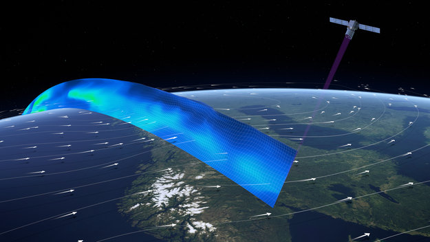
This edition of Euronews comes from northern Norway to meet scientists working on ESA’s newly-launched Aeolus wind mission
Talking sea-level
21.9.2018 16:30 ESA Observing the Earth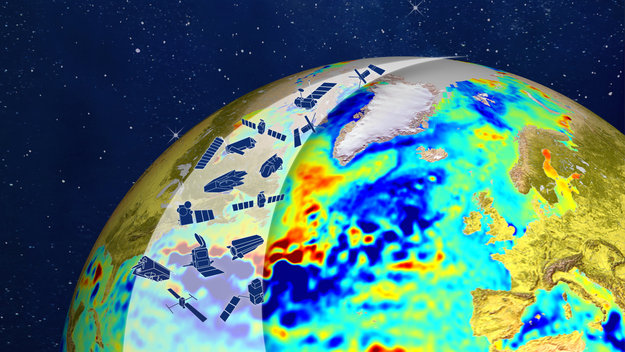
Scientists from all over the world are meeting in the Azores to talk about satellite altimeters and sea-level rise. Watch the opening session live on 24 September at 08:55 GMT (10:55 CEST)
Talking sea-level
21.9.2018 16:30 ESA Observing the EarthScientists from all over the world are meeting in the Azores to talk about satellite altimeters and sea-level rise. Watch the opening session live on 24 September at 09:00 GMT (11:00 CEST)
The Industrialization of BIM Workflows
21.9.2018 15:50 Bentley SystemsPress Coverage
Cadalyst, USA
Read the articleCooperative Effort Takes Off
21.9.2018 15:45 Bentley SystemsPress Coverage
xyHt, USA
Read the article#SAIC18 showed that Siemens is more than the sum of its parts
21.9.2018 15:37 Bentley SystemsPress Coverage
Schnitger Group, USA
Read the articleImproving Cell Antenna Fidelity With Precise Reality Meshes
21.9.2018 15:30 Bentley SystemsPress Coverage
Civil + Structural Engineer, USA
Read the articleAktualizace dat ÚAP od poskytovatele NET4GAS, s.r.o.
21.9.2018 15:20 Plzeňský kraj V datech územně analytických podkladů Plzeňského kraje byla provedena kompletní aktualizace dat technické infrastruktury od poskytovatele NET4GAS, s.r.o. Data jsou s platností k 27. 7. 2018.Be the first to benefit from the GNSS User Technology Report at ION GNSS+
21.9.2018 15:07 European GNSS Agency
The European GNSS Agency, in cooperation with the European Commission, is to hold a presentation of the second issue of its GNSS User Technology Report at the ION GNSS+ 2018 conference in Miami on Thursday 27 September.
The GSA publishes its 2018 GNSS User Technology Report on 24 September 2018, taking an in-depth look at the latest in state-of-the-art GNSS receiver technology and providing expert analysis on the trends that will shape the global GNSS landscape in the coming years.
Since its launch in 2016, the GNSS User Technology Report has become the go-to-source for comprehensive information on the dynamic global GNSS technology industry. The Report also provides an in-depth look at applications and solutions within the mass market, transport safety- and liability-critical, and high precision and timing domains, with a focus on new exciting trends and drivers.
Be the first to benefit
The GSA is organising a side event at this year’s ION GNSS+ in Miami at which it will present key elements of the new Report. The presentation, which will be held at 14:00 in the Orchid Room of the Hyatt Regency Miami on 27 September, will be an opportunity to learn about breakthrough GNSS technology innovations expected in the coming years and to listen to testimonials from the chipset industry and application developers, who will present results from the use of dual frequency and PPP in the mass market.
Are you ready to take the pulse of the GNSS user technology industry and get an inside view on how the latest trends are changing the market? Then don’t miss out on this opportunity to be among the first to benefit from the insights in the new GNSS User Technology Report.
Some highlights from this year’s GNSS User Technology Report
|
ION GNSS+
ION GNSS+ is the world's largest technical meeting and showcase of GNSS technology, products and services. This year's conference will bring together international leaders in GNSS and related positioning, navigation and timing fields to present new research, introduce new technologies, discuss current policy, demonstrate products and exchange ideas.
The GSA GNSS User Technology Report won’t be officially launched until September 24, but you can already register to be automatically notified when it is available to download.
Media note: This feature can be republished without charge provided the European GNSS Agency (GSA) is acknowledged as the source at the top or the bottom of the story. You must request permission before you use any of the photographs on the site. If you republish, we would be grateful if you could link back to the GSA website (http://www.gsa.europa.eu).
20180921 - volné místo - Odborný/vrchní referent v oddělení PV k nemovitostem KP Ústí n.l.
21.9.2018 13:28 ČÚZK - předpisy a opatření Katastrální úřad pro Ústecký kraj - Katastrální pracoviště Ústí nad Labem zveřejnil novou aktualitu: Nabídka volného pracovního místa - Odborný referent/vrchní referent v oddělení právních vztahů k nemovitostem KP Ústí nad Labem na Katastrálním úřadu pro Ústecký kraj20180921 - volné místo - Odborný/vrchní referent v oddělení PV k nemovitostem KP Ústí n.l.
21.9.2018 13:28 ČÚZK /Urady/Katastralni-urady/Katastralni-urady/Katastralni-urad-pro-Ustecky-kraj/O-uradu/Aktuality/20180921-volne-misto-Odborny-vrchni-referent-vOdborný referent/vrchní referent v oddělení právních vztahů k nemovitostem KP Ústí nad Labem na Kata
21.9.2018 13:22 ČÚZK /Urady/Katastralni-urady/Katastralni-urady/Katastralni-urad-pro-Ustecky-kraj/Uredni-deska/Oznameni-a-jina-uredni-sdeleni/Volna-mista/Odborny-referent-vrchni-referent-v-oddeleni-pravniOdborný referent/vrchní referent v oddělení právních vztahů k nemovitostem KP Ústí nad Labem na Kata
21.9.2018 13:22 ČÚZK - předpisy a opatření Katastrální úřad pro Ústecký kraj - Katastrální pracoviště Ústí nad Labemvypisuje výběrové řízení na místo
Odborný referent/vrchní referent v oddělení právních vztahů k nemovitostem KP Ústí nad Labem na Katastrálním úřadu pro Ústecký kraj
Odborný referent/vrchní referent v oddělení právních vztahů k nemovitostem KP Ústí nad Labem na Kata
21.9.2018 13:22 ČÚZK - volná místa Katastrální úřad pro Ústecký kraj - Katastrální pracoviště Ústí nad Labem vypisuje výběrové řízení na místo Odborný referent/vrchní referent v oddělení právních vztahů k nemovitostem KP Ústí nad Labem na KataThree Earth Explorer ideas selected
21.9.2018 12:40 ESA Observing the Earth
As part of ESA’s continuing commitment to realise cutting-edge satellite missions to advance scientific understanding of our planet and to show how new technologies can be used in space, three new ideas have been chosen to compete as the tenth Earth Explorer mission.
"Complete and Accurate U.S. Census is the Goal for 2020" by Susan Smith
21.9.2018 12:21 GISCafe.com Webcasts-WebinarsOpakovaná výzva - automobil Suzuki Ignis kombi
21.9.2018 10:22 ČÚZK /Urady/Katastralni-urady/Katastralni-urady/Katastralni-urad-pro-Kralovehradecky-kraj/Nabidky-majetku/Opakovana-vyzva-automobil-Suzuki-Ignis-kombiOpakovaná výzva - automobil Suzuki Ignis kombi
21.9.2018 10:22 ČÚZK - předpisy a opatřeníKatastrální úřad pro Královéhradecký kraj nabízí nepotřebný majetek k odkupu. Jedná se o
Opakovaná výzva - automobil Suzuki Ignis kombi
Enhanced UseGalileo site offers a more tailored experience
21.9.2018 10:20 European GNSS Agency
To keep up with the increasing interest in Galileo and the many new Galileo-enabled devices and services coming onto the market, the European GNSS Agency (GSA) launched an enhanced version of its popular UseGalileo.eu site.
Since the launch of Initial Services in December 2016, Galileo has been providing more and more users with global positioning, navigation and timing information.
Behind this increase in use is the wide array of Galileo-enabled devices and services that have entered the market over the past couple of years. Just think, back in 2016 there was only one smartphone with Galileo capability. Today, less than two years later, there are over 60 models.
But it’s not just smartphones: Galileo can now be found in applications and devices ranging from tablets to wearables and from aircraft to personal vehicles. For example, as of April, all new types of cars sold in the EU must be equipped with Galileo as required by the eCall regulation. Galileo is also being increasingly used in drones to ensure smooth navigation and in Search and Rescue operations to save lives.
The new UseGalileo
With this increased interest in Galileo, both the general public and industry want to know what devices are Galileo-capable. As new devices are constantly being added to the list, the GSA launched an enhanced version of its popular UseGalileo.eu website.
“We are proud to see how quickly Galileo is being embraced by European citizens and businesses,” says GSA Executive Director Carlo des Dorides. “UseGalileo is the perfect tool to showcase the results of the commitment by the people behind the European space programme.”
Watch this: Who is using Galileo today?
The enhanced site, which allows users to easily search and keep track of Galileo-enabled devices as they become available, includes several new features. Regular users will notice the addition of categories covering applications in the timing, Internet of Things (IoT) and space application segments. Furthermore, other categories, such as aviation, emergency services and agriculture, now include a number of sub-categories. For example, within the aviation segment, users can narrow their search to Galileo-enabled devices and applications for avionics, airports and Unmanned Aerial Vehicles (UAVs). Flight operators can even search per their particular aircraft, whether that be a business jet, a helicopter or a commercial airliner.
“Through a number of tailored products, the GSA is able to cater to the unique needs of different user communities,” adds des Dorides. “The enhanced UseGalileo site and its many segment-specific search functions is another example of how we keep the user at the centre of European GNSS.”
Media note: This feature can be republished without charge provided the European GNSS Agency (GSA) is acknowledged as the source at the top or the bottom of the story. You must request permission before you use any of the photographs on the site. If you republish, we would be grateful if you could link back to the GSA website (http://www.gsa.europa.eu).
Earth from Space
21.9.2018 10:05 ESA Observing the Earth
In this week's edition, discover the largest island of the Azores: São Miguel
São Miguel
21.9.2018 10:05 ESA Observing the Earth
Earth observation image of the week: Sentinel-2 takes us over São Miguel in the Azores
Interview with Janice Engelgau, Social Outreach Specialist at Fruity Chutes at InterDrone2018
21.9.2018 9:00 GISCafe.com Webcasts-WebinarsTextron to Release Third Quarter Results on October 18, 2018
21.9.2018 9:00 GISCafe.com Webcasts-Webinars PROVIDENCE, R.I. — (BUSINESS WIRE) — September 18, 2018 — Textron Inc. (NYSE: TXT) will release its third quarter 2018 financial …Plánovaný výpadek Geoportálu ÚAP ve dnesch 27.9. - 30.9.2018
21.9.2018 8:50 Ústecký krajVe dnech 27.9. - 30.9.2018 nebude Pasportizační systém dostupný z důvodu údržby serverů Krajského úřadu Ústeckého kraje.
Děkujeme za pochopení.
Pozvánka na zářijový Missing Maps mapathon v Praze
21.9.2018 8:25 GISportal.cz
V úterý 25. září se od 18 do 21 hodin bude konat další pražský Missing Maps mapathon. Mapathon se bude konat ve Wine Food Marketu (Strakonická 1, Praha). Přihlásit se můžete online a jako u ostatních mapathonů, stačí si donést vlastní pc (ideálně i myš) a můžete začít mapovat. Zkušení organizátoři Vám určitě rádi pomohou.
The post Pozvánka na zářijový Missing Maps mapathon v Praze appeared first on GISportal.cz.
Nabídka nepotřebného majetku - 09/2018
21.9.2018 7:37 ČÚZK /Urady/Katastralni-urady/Katastralni-urady/Katastralni-urad-pro-Ustecky-kraj/Nabidky-majetku/Nabidka-nepotrebneho-majetku-09-2018Nabídka nepotřebného majetku - 09/2018
21.9.2018 7:37 ČÚZK - předpisy a opatřeníKatastrální úřad pro Ústecký kraj nabízí nepotřebný majetek k odkupu. Jedná se o
Nabídka nepotřebného majetku - 09/2018
Doktorandský geoseminář
21.9.2018 6:40 Blogující geomatici - FAV ZČUAktualizace základního mapování biotopů
21.9.2018 2:00 Cenia - Katalog metadat ČR - INSPIRE Aktualizace vrstvy segmentů biotopů a relačních databází (biotopy, taxony) probíhá v pravidelných cyklech. Frekvence cyklů aktualizace je plánována jako 12letá. Aktualizace byla zahájena v roce 2007. Ve vrstvě a tabulkách jsou aktualizované a neaktualizované záznamy (pole ROK_AKT). Vrstva obsahuje hranice segmentů přírodních biotopů a biotopů silně ovlivněných nebo vytvořených člověkem z aktualizace základního mapování biotopů. Znalost rozšíření biotopů silně ovlivněných nebo vytvořených člověkem není plošná, vrstva poskytuje informace o rozšíření nepřírodních biotopů pouze na malé části území ČR.Data z mapování biotopů neposkytují vyčerpávající informaci o vegetaci, resp. biotopech daného území. Mapování je metodicky nastaveno na celostátní úrovni, a především efemérní biotopy tak může pominout. V lokálním měřítku proto představuje pouze zjednodušený podklad. Pro detailnější informaci je třeba vyhledat jiné datové zdroje. Základní mapování bylo provedeno v letech 2001–2005.Klasifikace biotopů viz CHYTRÝ, M.; KUČERA, T.; KOČÍ, M. (eds.) et al. (2010). Katalog biotopů České republiky. 2.upr. a rozš.vyd. Praha: Agentura ochrany přírody a krajiny ČR. 445 s. ISBN 978-80-87457-03-0.Popis charakteristik biotopů a segmentů viz platná metodika mapování biotopů (Portál ISOP/Mapování biotopů). Botanická nomenklatura převzata z Nálezové databáze OP (http://isop.nature.cz/redlist/v_nd_taxon_category.php). Vrstva obsahuje jednoduché prvky (Singlepart Features), kardinalita vztahu tabulek je 1 : N. © AOPK ČR, 2018Continental Mapping Announces Board of Advisors
21.9.2018 1:04 GISCafe.com Webcasts-Webinars Board will seek to continue firm's steady growth.SUN PRAIRIE, Wis., Sept. 20, 2018 — (PRNewswire) —
SUN PRAIRIE, Wis., Sept. 20, 2018 …
Hoverfly to Unveil Its High-Tech Enterprise Level Drone System at GSX
20.9.2018 17:28 GISCafe.com Webcasts-Webinars ORLANDO, Fla., Sept. 20, 2018 — (PRNewswire) — Hoverfly Technologies Inc., America's leading tether-powered drone (UAS) …CoreLogic Reports Strong Economy Boosts Homeowner Equity by About $1 Trillion in the Second Quarter of 2018
20.9.2018 17:28 GISCafe.com Webcasts-Webinars The share of properties in negative equity fell to 4.3 percent inthe second quarter 2018
Approximately 221,000 …
Esri Founder and President Jack Dangermond to Keynote International Conference on Assessment Administration
20.9.2018 17:28 GISCafe.com Webcasts-Webinars Conference Guests Will Learn How Location Intelligence EnablesProperty Appraisal
REDLANDS, Calif. — (BUSINESS WIRE) — …
Mist Introduces State-of-the-Art Indoor Wireless Location Services, Launching the Breakthrough Technology at the Walt Disney World Swan and Dolphin Resort
20.9.2018 17:28 GISCafe.com Webcasts-Webinars CUPERTINO, Calif., Sept. 20, 2018 (GLOBE NEWSWIRE) -- Mist, the pioneer in self-learning networks powered by artificial intelligence (AI), …Technology, Industry and Market of Safe Cities expected to face new challenges and opportunities
20.9.2018 17:28 GISCafe.com Webcasts-Webinars WASHINGTON, Sept. 20, 2018 — (PRNewswire) — According to a market research report "Safe City Market, Technologies & Industry - …NavVis Achieves Breakthough 6D SLAM Indoor LiDAR Mapping With Velodyne’s 3D LiDAR Sensor
20.9.2018 17:25 GISCafe.com Webcasts-Webinars SAN JOSE, Calif. — (BUSINESS WIRE) — September 20, 2018 —On April 18th, 2018, NavVis released their M6, a
…
Canon Redefines the Large Format Printer with the Versatile imagePROGRAF TM Series, New MFPs Models
20.9.2018 17:25 GISCafe.com Webcasts-Webinars MELVILLE, N.Y., Sept. 20, 2018 — (PRNewswire) — Offering a new versatile large format printing solution, Canon U.S.A., Inc., a …Dokončena integrace prvního servisního modulu lodi Orion
20.9.2018 16:27 Český Kosmický PortálV polovině září došlo v integrační hale společnosti Airbus v německých Brémách k instalaci posledního radiátoru na evropský servisní modul ESM (European Service Module) pro novou kosmickou loď NASA Orion. Tím bylo dokončeno jeho sestavování.
Dokončena integrace prvního servisního modulu lodi Orion
20.9.2018 16:27 Český Kosmický PortálV polovině září došlo v integrační hale společnosti Airbus v německých Brémách k instalaci posledního radiátoru na evropský servisní modul ESM (European Service Module) pro novou kosmickou loď NASA Orion. Tím bylo dokončeno jeho sestavování.
Aktualizace údajů
20.9.2018 14:19 Ústecký kraj V Geoportálu ÚAP Ústeckého kraje byla provedena aktualizace údajů pro poskytovatele ČEPS, a. s. – jev 72, 73, České Radiokomunikace a.s. – jev 81, 82 a Agentura ochrany přírody a krajiny České republiky – jev 27, 28, 29, 313D řešení pro architekty a projektanty
20.9.2018 11:10 HrdličkaBIM, na rozdíl od tradičního zpracování pomocí CAD programů, umožňuje zcela nový způsob práce. Data zůstávají konzistentní pro všechny zúčastněné strany i přes velké množství změn, prováděných jednotlivými operátory. BIM je možné si představit jako komplexní databázi, kde každý objekt je jedním prvkem této databáze a může obsahovat geometrické i negrafické informace. Jakákoliv změna jednoho... View Article
The post 3D řešení pro architekty a projektanty appeared first on HRDLIČKA spol. s r.o. - komplexní služby v oblasti geodézie.
20180920 - volné místo - Rada/odborný rada v oddělení OKO I. v technickém odboru na KÚ pro Úst.kraj
20.9.2018 10:50 ČÚZK /Urady/Katastralni-urady/Katastralni-urady/Katastralni-urad-pro-Ustecky-kraj/O-uradu/Aktuality/20180820-volne-misto-Rada-odborny-rada-v-oddel20180920 - volné místo - Rada/odborný rada v oddělení OKO I. v technickém odboru na KÚ pro Úst.kraj
20.9.2018 10:50 ČÚZK - předpisy a opatření Katastrální úřad pro Ústecký kraj zveřejnil novou aktualitu: Nabídka volného pracovního místa - Rada/odborný rada v oddělení OKO I. v technickém odboru na Katastrálním úřadu pro Ústecký krajRada/odborný rada v oddělení OKO I. v technickém odboru na Katastrálním úřadu pro Ústecký kraj
20.9.2018 10:45 ČÚZK - předpisy a opatření Katastrální úřad pro Ústecký kraj - technický odborvypisuje výběrové řízení na místo
Rada/odborný rada v oddělení OKO I. v technickém odboru na Katastrálním úřadu pro Ústecký kraj
Rada/odborný rada v oddělení OKO I. v technickém odboru na Katastrálním úřadu pro Ústecký kraj
20.9.2018 10:45 ČÚZK - volná místa Katastrální úřad pro Ústecký kraj - technický odbor vypisuje výběrové řízení na místo Rada/odborný rada v oddělení OKO I. v technickém odboru na Katastrálním úřadu pro Ústecký krajRada/odborný rada v oddělení OKO I. v technickém odboru na Katastrálním úřadu pro Ústecký kraj
20.9.2018 10:45 ČÚZK /Urady/Katastralni-urady/Katastralni-urady/Katastralni-urad-pro-Ustecky-kraj/Uredni-deska/Oznameni-a-jina-uredni-sdeleni/Volna-mista/Rada-odborny-rada-v-oddeleni-OKO-I-v-technickem-oVynikající úspěch na INSPIRE Hackathon 2018
20.9.2018 10:40 Blogující geomatici - FAV ZČU Včera byly na probíhající INSPIRE konferenci v belgických Atwerpách vyhlášeny výsledky již tradičního doprovodného INSPIRE Hackathonu. Z letošních 15 přihlášených týmů vybrala mezinárodní porota ve složení Esther Huyer (Consultant at Capgemini Consulting), Anca Popescu (RTDI Project Officer at European Union Satellite Centre), Lorenzino Vaccari (Senior researcher at the JRC Ispra) a Bart De Lathouwer (Open Geospatial Consoritum) tři nejlepší výsledky. První místo obsadil tým TEAM 12 s tématem Delimiting of agro-climatic zones ve složení Karel Jedlička, Pavel Hájek (ZČU), Karl Gutbrodt (Meteoblue, CH), Marcela Doubková a Apurva Kochar (obě PESSL Instruments, AT). Blahopřejeme!Finálová prezentace týmu
Vynikající úspěch na INSPIRE Hackathon 2018
20.9.2018 10:40 Blogující geomatici - FAV ZČU Včera byly na probíhající INSPIRE konferenci v belgických Atwerpách vyhlášeny výsledky již tradičního doprovodného INSPIRE Hackathonu. Z letošních 15 přihlášených týmů vybrala mezinárodní porota ve složení Esther Huyer (Consultant at Capgemini Consulting), Anca Popescu (RTDI Project Officer at European Union Satellite Centre), Lorenzino Vaccari (Senior researcher at the JRC Ispra) a Bart De Lathouwer (Open Geospatial Consoritum) tři nejlepší výsledky. První místo obsadil tým TEAM 12 s tématem Delimiting of agro-climatic zones ve složení Karel Jedlička, Pavel Hájek a další kolegové z projektu EUXDAT - Karl Gutbrodt, Marcela Doubková a Apurva Kochar. Soutěžní projekt byl prototypem scénáře připravovaného v rámci projektu EUXDAT. Blahopřejeme vítězům!Finálová prezentace týmu
Nabídka nepotřebného majetku - Fabia Combi Ambient
20.9.2018 10:08 ČÚZK /Urady/Katastralni-urady/Katastralni-urady/Katastralni-urad-pro-Olomoucky-kraj/Nabidky-majetku/Nabidka-nepotrebneho-majetku-Fabia-Combi-AmbientNabídka nepotřebného majetku - Fabia Combi Ambient
20.9.2018 10:08 ČÚZK - předpisy a opatřeníKatastrální úřad pro Olomoucký kraj nabízí nepotřebný majetek k odkupu. Jedná se o
Nabídka nepotřebného majetku - Fabia Combi Ambient
Videoseminář 2018 – díl druhý
20.9.2018 9:53 ARCDATAMáte prostorová data a potřebujete s nimi pracovat v prostředí webového GIS, ale nechcete čekat, až je administrátor GIS nahraje do databáze a publikuje na ArcGIS Serveru? Jde to i jinak, neváhejte a nahlédněte do světa hostovaných vektorových dat.
Nový portál MAWIS a upgrade služby UtilityReport
20.9.2018 9:39 HrdličkaPortál MAWIS Ze standardní webové stránky jsme vytvořili úplně nový portál, který je schopen obsloužit kteréhokoliv návštěvníka, uživatele nebo zákazníka a nabízí spoustu nového: 1. Přímá registrace skrze formulář a po následném přihlášení i možnost úprav osobních nebo firemních údajů. Vše v souladu s platnými nařízeními GDPR o ochraně osobních údajů. 2. Součástí nového portálu je také e-shop,... View Article
The post Nový portál MAWIS a upgrade služby UtilityReport appeared first on HRDLIČKA spol. s r.o. - komplexní služby v oblasti geodézie.
Nový portál MAWIS a upgrade služby UtilityReport
20.9.2018 9:39 HrdličkaPortál MAWIS Ze standardní webové stránky jsme vytvořili úplně nový portál, který je schopen obsloužit kteréhokoliv návštěvníka, uživatele nebo zákazníka a nabízí spoustu nového: Přímá registrace skrze formulář a po následném přihlášení i možnost úprav osobních nebo firemních údajů. Vše v souladu s platnými nařízeními GDPR o ochraně osobních údajů. Součástí nového portálu je také e-shop, kde je... View Article
The post Nový portál MAWIS a upgrade služby UtilityReport appeared first on HRDLIČKA spol. s r.o. - komplexní služby v oblasti geodézie.
Odborný referent v oddělení dokumentace KN na Katastrálním pracovišti Kyjov
20.9.2018 9:28 ČÚZK /Urady/Katastralni-urady/Katastralni-urady/Katastralni-urad-pro-Jihomoravsky-kraj/Uredni-deska/Oznameni-a-jina-uredni-sdeleni/Volna-mista/Odborny-referent-v-oddeleni-dokumentace-KN-na-KataOdborný referent v oddělení dokumentace KN na Katastrálním pracovišti Kyjov
20.9.2018 9:28 ČÚZK - volná místa Katastrální úřad pro Jihomoravský kraj - Katastrální pracoviště Kyjov vypisuje výběrové řízení na místo Odborný referent v oddělení dokumentace KN na Katastrálním pracovišti KyjovOdborný referent v oddělení dokumentace KN na Katastrálním pracovišti Kyjov
20.9.2018 9:28 ČÚZK - předpisy a opatření Katastrální úřad pro Jihomoravský kraj - Katastrální pracoviště Kyjovvypisuje výběrové řízení na místo
Odborný referent v oddělení dokumentace KN na Katastrálním pracovišti Kyjov
Mapová aplikace ÚPD - nové dokumentace
20.9.2018 9:20 Jihočeský kraj V mapové aplikaci Územně plánovací dokumentace obcí byla aktualizována územně plánovací dokumentace obcí České Budějovice, Dolní Žďár, Homole, Chotýčany, Kraselov, Libníč, Lipí, Malšín, Myštice, Nedabyle, Sedlec, Srubec, Strakonice, Strážkovice, Tábor a Zliv. Nově pak byla přidána územně plánovací dokumentace obce Vlastiboř.Interview with Michael Chasen, CEO at PrecisionHawk at InterDrone2018
20.9.2018 9:00 GISCafe.com Webcasts-WebinarsNová aplikace pro cestující veřejnost v Olomouckém kraji (TZ)
20.9.2018 8:28 GISportal.cz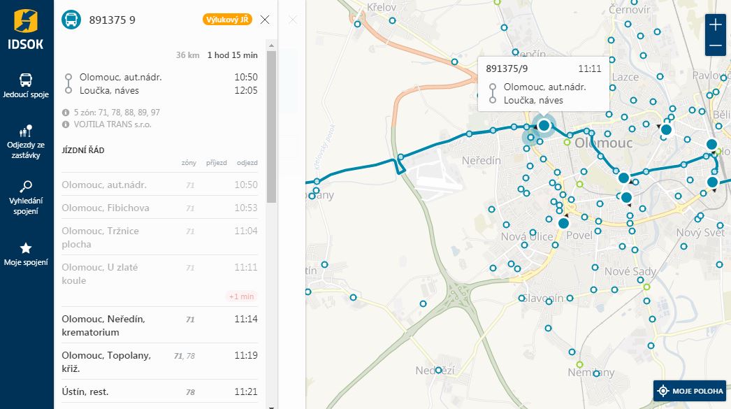
Společnost T-MAPY ve spolupráci s Koordinátorem integrovaného dopravního systému Olomouckého kraje (KIDSOK), který vznikl v roce 2012 jako příspěvková organizace Olomouckého kraje, vytvořily novou webovou aplikaci pro cestující v Olomouckém kraji. Ta umožňuje získat přehled o aktuálně jedoucích spojích veřejné hromadné dopravy, jejich jízdních řádech včetně případných zpoždění a odjezdech z jednotlivých zastávek, resp. stanic. K […]
The post Nová aplikace pro cestující veřejnost v Olomouckém kraji (TZ) appeared first on GISportal.cz.
Podzimní školení GISMentors
20.9.2018 7:00 Česká asociace pro geoinformace GIS Mentors zveřejnili na svém webu seznam podzimních školení pro začátečníky i pokročilé v těchto oblastech:QGIS
PostGIS
GeoPython
GRASS
Opatřování výstupů kvalifikovanou elektronickou pečetí
20.9.2018 6:31 Dálkový přístup k údajům KN ČR Vážení uživatelé,od 18.9.2018 jsou výstupy opatřovány kvalifikovanou elektronickou pečetí v souladu s eIDAS (nařízení EU č. 910/2014) a zákonem o službách vytvářejících důvěru (zák.č.297/2016 Sb.).
Opatřování výstupů kvalifikovanou elektronickou pečetí
20.9.2018 6:31 ČÚZK /Aplikace-DP-do-KN/Aplikace-DP-do-KN/Archiv-DP/232542Opatřování výstupů kvalifikovanou elektronickou pečetí
20.9.2018 6:31 ČÚZK - předpisy a opatření Vážení uživatelé,od 18.9.2018 jsou výstupy opatřovány kvalifikovanou elektronickou pečetí v souladu s eIDAS (nařízení EU č. 910/2014) a zákonem o službách vytvářejících důvěru (zák.č.297/2016 Sb.).
Státní pozemkový úřad se dlouhodobě zapojuje do boje se suchem
20.9.2018 0:00 Státní pozemkový úřad Praha, 20. září 2018 – V rámci pozemkových úprav Státní pozemkový úřad doposud zrealizoval vodohospodářská opatření na ploše cca 558 ha a protierozní opatření na přibližně 771 ha. Jen v roce 2017 byla v pozemkových úpravách vybudována vodohospodářská opatření na ploše téměř 89 ha. Na tyto realizace vynaložil Státní pozemkový úřad více než 210 milionů korun.Mobile Mapping Market to Surpass $40bn by 2024: Global Market Insights, Inc.
19.9.2018 20:31 GISCafe.com Webcasts-Webinars SELBYVILLE, Delaware, September 19, 2018 — (PRNewswire) — The research report "Mobile Mapping Market Size, By Component (Hardware …Esri Location Intelligence Empowers Innovation at the US Navy's Premier Digital Event
19.9.2018 20:30 GISCafe.com Webcasts-Webinars Esri Sponsors HACKtheMACHINE to Showcase Rapid App Development forMaritime Operations
REDLANDS, Calif. — (BUSINESS …
Laserpas Chooses Neurala to Enable AI-Powered Drone Inspection and Analysis of Industrial Power Grid Components
19.9.2018 20:30 GISCafe.com Webcasts-Webinars One of the Largest Utility Asset Management Companies in the EUPartners With Leader in Deep Learning Neural Networks to Power Drones
…
TomTom Bridge Hub to Power Connected Navigation & Professional Mobility Services
19.9.2018 20:30 GISCafe.com Webcasts-Webinars HANNOVER, Germany — (BUSINESS WIRE) — September 19, 2018 —IAA Hannover -- TomTom (TOM2)
today announced that its …
Sensofusion to Unveil Next Generation Counter-UAS System AIRFENCE: Hosting Exclusive Demo this Fall
19.9.2018 20:29 GISCafe.com Webcasts-Webinars Open invitation to end-users to participate in counter-UAS demo featuring AIRFENCE 6.0NEW YORK, Sept. 19, 2018 — (PRNewswire) — …
BAE Systems to Provide Actionable GEOINT Capability for the National Geospatial-Intelligence Agency’s Janus Portfolio
19.9.2018 20:29 GISCafe.com Webcasts-Webinars MT. LAUREL, N.J. — (BUSINESS WIRE) — September 19, 2018 —The National Geospatial-Intelligence Agency (NGA) has selected BAE …
Planet and Orbital Insight Expand Satellite Imagery Partnership
19.9.2018 20:28 GISCafe.com Webcasts-Webinars Greater access to Planet's medium- and high-resolution satellite imagery adds to Orbital Insight's global coverageSAN FRANCISCO and PALO ALTO, …
Fortress UAV Launches Fortress UAV Protect, A Preventative Maintenance Program
19.9.2018 20:28 GISCafe.com Webcasts-Webinars PLANO, Texas, Sept. 19, 2018 — (PRNewswire) — Fortress UAV, a leading provider of drone repair services, announces the launch of …Collaborative Construction Management
19.9.2018 15:32 Bentley SystemsPress Coverage
Civil + Structural Engineer, USA
Read the articleMapová aplikace ÚAP - aktualizace
19.9.2018 15:30 Jihočeský kraj Mapová aplikace Územně analytické podklady byla aktualizována k 18. 9. 2018.Raymond To Test Drives MicroStation CONNECT Edition
19.9.2018 15:24 Bentley SystemsPress Coverage
MicroStation Connections, USA
Read the articleTopcon introduces new software for UAV inspection applications
19.9.2018 14:51 Bentley SystemsPress Coverage
Geospatial World, India
Read the articleMicroStation CONNECT Edition User of the Month Profile for August
19.9.2018 14:46 Bentley SystemsPress Coverage
MicroStation Connections, USA
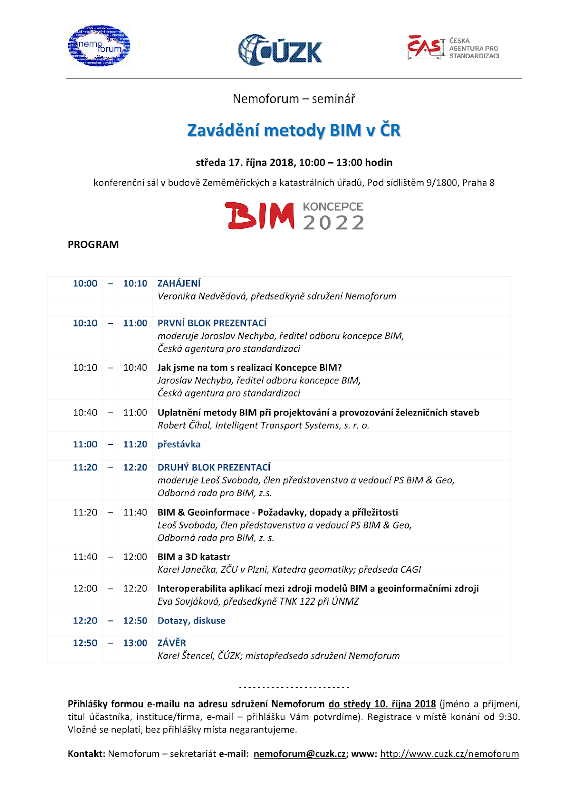
Read the articlePozvánka na seminář "Zavádění metody BIM v ČR"
19.9.2018 14:20 Blogující geomatici - FAV ZČU Rádi bychom pozvali na seminář pořádaný Nemoforem na téma "Zavádění metody BIM v ČR", který se uskuteční ve středu 17. 10. 2018 od 10 do 13 hodin. Podrobný program tohoto semináře najdete v přiloženém obrázku.Přihlášky formou e-mailu na adresu sdružení Nemoforum (nemoforum AT cuzk.cz) do středy 10. října 2018 (jméno a příjmení, titul účastníka, instituce/firma, e-mail – přihlášku Vám potvrdíme).
Living Planet 2019
19.9.2018 13:25 ESA Observing the Earth
ESA’s next Living Planet Symposium will take place on 13–19 May 2019 in Milan, Italy. Abstracts can now be submitted. Deadline: 11 November
CEDA se poprvé zapojí do evropského projektu
19.9.2018 12:45 CEDA Maps a.s. Praha, 17. září 2018 - Společnost CEDA se od září tohoto roku prvně zapojí do nadnárodního projektu Green Your Route: A European innovative logistic platform for last mile delivery of goods in urban environment realizovaného v rámci evropského programu LIFE.Global Mapper v.20 Now Available with Improved 3D Model Functionality and New Map Layout Options
19.9.2018 12:33 GISCafe.com Webcasts-Webinars Hallowell, Maine – September 18, 2018 - Blue Marble Geographics (bluemarblegeo.com) is pleased to announce the immediate availability of …Bezpečnostní opatření dne 25.09.2018
19.9.2018 11:44 ČÚZK - předpisy a opatření Katastrální úřad pro Karlovarský kraj - Katastrální pracoviště Sokolov zveřejnil novou aktualitu: Vážení klienti, v návaznosti na níže uvedené bezpečnostní opatření Policie ČR Vám doporučujeme, abyste v úterý 25. 09. 2018 své záležitosti na Katastrálním pracovišti Sokolov vyřizovali přednostně v dopoledních hodinách, nebo je přesunuli na jiný den, zejména pokud se k budově našeho pracoviště dopravujete autem. Nejsme schopni odhadnout, jaká bude v okolí naší budovy dopravní situace a tímto doporučením bychom Vám rádi ušetřili případné potíže s dopravou nebo parkováním.(Zpravodajství krajského ředitelství PČR KV)
Ing. Martin Raška, Ph.D.
ředitel katastrálního pracoviště Sokolov
Bezpečnostní opatření dne 25.09.2018
19.9.2018 11:44 ČÚZK /Urady/Katastralni-urady/Katastralni-urady/Katastralni-urad-pro-Karlovarsky-kraj/Katastralni-pracoviste/KP-Sokolov/O-uradu/Aktuality/Bezpecnostni-opatreni-dne-25-09-2018Bezpečnostní opatření dne 25.09.2018
19.9.2018 11:44 ČÚZK - předpisy a opatření Katastrální úřad pro Karlovarský kraj - Katastrální pracoviště Sokolov zveřejnil novou aktualitu: Vážení klienti, v návaznosti na níže uvedené bezpečnostní opatření Policie ČR Vám doporučujeme, abyste v úterý 25. 09. 2018 své záležitosti na Katastrálním pracovišti Sokolov vyřizovali přednostně v dopoledních hodinách, nebo je přesunuli na jiný den, zejména pokud se k budově našeho pracoviště dopravujete autem. Nejsme schopni odhadnout, jaká bude v okolí naší budovy dopravní situace a tímto doporučením bychom Vás rádi ušetřili případné potíže s dopravou nebo parkováním.(Zpravodajství krajského ředitelství PČR KV)
Ing. Martin Raška, Ph.D.
ředitel katastrálního pracoviště Sokolov
Bluesky and Getmapping Win Aerial Photography for GB Government Contract
19.9.2018 9:00 GISCafe.com Webcasts-Webinars September 19, 2018 -- Aerial mapping companies Bluesky and Getmapping are pleased to announce that, working with UK, Welsh, and Scottish governments, …Interview with Rebecca Lasica, Director of Commercial Business at Harris Geospatial at InterDrone 2018
19.9.2018 9:00 GISCafe.com Webcasts-WebinarsAko vyzerá zemský povrch osvetlený nočným svetlom?
19.9.2018 8:30 GISportal.cz
Peknú aplikáciu, ktorá vizuálne poukazuje na to, ako vyzerá zemský povrch, ktorý je osvetlený nočným svetlom predstavil Jacob Wasilkowski. Táto aplikácia používa ArcGIS API a JavaScript na vytvorenie 2D tematických dát a následné zobrazenie v 3D. Aplikácia sa nachádza na tejto stránke a video, ktoré ju v krátkosti približuje je dostupné tu.
The post Ako vyzerá zemský povrch osvetlený nočným svetlom? appeared first on GISportal.cz.
Habitaty (základní mapování biotopů)
19.9.2018 2:00 Cenia - Katalog metadat ČR - INSPIRE Hranice segmentů habitatů a relační databáze jejich charakteristik ze základního mapování biotopů; převodní tabulka habitatů viz CHYTRÝ, M.; KUČERA, T.; KOČÍ, M. (eds.) (2001). Katalog biotopů České republiky: Interpretační příručka k evropským programům Natura 2000 a Smaragd. Vyd. 1. Praha: Agentura ochrany přírody a krajiny ČR. 307 s. ISBN 80-86064-55-7.; vrstva obsahuje jednoduché prvky (Singlepart Features), kardinalita vztahu mezi záznamy v tabulkách 1 : N; © AOPK ČR, 2006Data z mapování biotopů neposkytují vyčerpávající informaci o vegetaci, resp. biotopech daného území. Mapování biotopů je opakováno v pravidelných cyklech, především efemérní biotopy mohou být pominuty. Je metodicky nastaveno na celostátní úrovni, v lokálním měřítku je pouze zjednodušeným podkladem. Pro detailnější informaci je třeba odborný průzkum či konzultace.Habitaty (aktualizace základního mapování biotopů)
19.9.2018 2:00 Cenia - Katalog metadat ČR - INSPIRE Hranice segmentů habitatů a relační databáze jejich charakteristik z aktualizace základního mapování biotopů; převodní tabulka habitatů viz CHYTRÝ, M.; KUČERA, T.; KOČÍ, M. (eds.) et al. (2010). Katalog biotopů České republiky. 2.upr. a rozš.vyd. Praha: Agentura ochrany přírody a krajiny ČR. 445 s. ISBN 978-80-87457-03-0.; vrstva obsahuje jednoduché prvky (Singlepart Features), kardinalita vztahu mezi záznamy v tabulkách 1 : N; © AOPK ČR, 2018Data z mapování biotopů neposkytují vyčerpávající informaci o vegetaci, resp. biotopech daného území. Mapování biotopů je opakováno v pravidelných cyklech, především efemérní biotopy mohou být pominuty. Je metodicky nastaveno na celostátní úrovni, v lokálním měřítku je pouze zjednodušeným podkladem. Pro detailnější informaci je třeba odborný průzkum či konzultace.Aktualizace základního mapování biotopů
19.9.2018 2:00 Cenia - Katalog metadat ČR - INSPIRE Aktualizace vrstvy segmentů biotopů a relačních databází (biotopy, taxony) probíhá v pravidelných cyklech. Aktualizace byla zahájena v roce 2007. Ve vrstvě a tabulkách jsou aktualizované a neaktualizované záznamy (pole ROK_AKT). Vrstva obsahuje hranice segmentů přírodních biotopů a biotopů silně ovlivněných nebo vytvořených člověkem z aktualizace základního mapování biotopů. Znalost rozšíření biotopů silně ovlivněných nebo vytvořených člověkem není plošná, vrstva poskytuje informace o rozšíření nepřírodních biotopů pouze na malé části území ČR.Data z mapování biotopů neposkytují vyčerpávající informaci o vegetaci, resp. biotopech daného území. Mapování je metodicky nastaveno na celostátní úrovni, a především efemérní biotopy tak může pominout. V lokálním měřítku proto představuje pouze zjednodušený podklad. Pro detailnější informaci je třeba vyhledat jiné datové zdroje. Základní mapování bylo provedeno v letech 2001–2005.Klasifikace biotopů viz CHYTRÝ, M.; KUČERA, T.; KOČÍ, M. (eds.) et al. (2010). Katalog biotopů České republiky. 2.upr. a rozš.vyd. Praha: Agentura ochrany přírody a krajiny ČR. 445 s. ISBN 978-80-87457-03-0.Popis charakteristik biotopů a segmentů viz platná metodika mapování biotopů (Portál ISOP/Mapování biotopů). Botanická nomenklatura převzata z Nálezové databáze OP (http://isop.nature.cz/redlist/v_nd_taxon_category.php). Vrstva obsahuje jednoduché prvky (Singlepart Features), kardinalita vztahu tabulek je 1 : N. © AOPK ČR, 2018Magnetometrie
19.9.2018 2:00 Cenia - Katalog metadat ČR - INSPIRE Databáze obsahuje magnetické anomálie delta T z leteckého geomagnetického mapování ČR v měřítku 1 : 25 000, které od roku 1960 začal systematicky plošně uskutečňovat prakticky výhradně Ústav užité geofyziky v Brně (později Geofyzika Brno), v současnosti v měření pokračuje firma Miligal s.r.o. Měření v letech v letech 1960-1971 bylo realizováno s analogovou registrací (fluxdate magnetometr) s přesností cca 10 nT. Další etapy měření byly již registrovány digitálně (protonový a cesiový magnetometr) s přesností cca 2 nT. Aeromagnetická měření jsou doplněna pozemním měřením (východní Morava, Krkonoše, Šumava).Přírodní biotopy (aktualizace základního mapování biotopů)
19.9.2018 2:00 Cenia - Katalog metadat ČR - INSPIRE Hranice segmentů přírodních biotopů a relační databáze jejich charakteristik z aktualizace základního mapování biotopů; klasifikace biotopů viz CHYTRÝ, M.; KUČERA, T.; KOČÍ, M. (eds.) et al. (2010). Katalog biotopů České republiky. 2.upr. a rozš.vyd. Praha: Agentura ochrany přírody a krajiny ČR. 445 s. ISBN 978-80-87457-03-0.; popis charakteristik biotopů a segmentů viz platná metodika mapování biotopů (Portál ISOP/Mapování biotopů); vrstva obsahuje jednoduché prvky (Singlepart Features), kardinalita vztahu mezi záznamy v tabulkách 1 : N; © AOPK ČR, 2018Data z mapování biotopů neposkytují vyčerpávající informaci o vegetaci, resp. biotopech daného území. Mapování biotopů je opakováno v pravidelných cyklech, především efemérní biotopy mohou být pominuty. Je metodicky nastaveno na celostátní úrovni, v lokálním měřítku je pouze zjednodušeným podkladem. Pro detailnější informaci je třeba odborný průzkum či konzultace.Přírodní biotopy (základní mapování biotopů)
19.9.2018 2:00 Cenia - Katalog metadat ČR - INSPIRE Hranice segmentů přírodních biotopů a relační databáze jejich charakteristik ze základního mapování biotopů; klasifikace biotopů viz CHYTRÝ, M.; KUČERA, T.; KOČÍ, M. (eds.) (2001). Katalog biotopů České republiky: Interpretační příručka k evropským programům Natura 2000 a Smaragd. Vyd. 1. Praha: Agentura ochrany přírody a krajiny ČR. 307 s. ISBN 80-86064-55-7.; popis charakteristik biotopů a segmentů viz Guth, J. (ed.), 2002: Metodiky mapování biotopů soustavy Natura 2000 a Smaragd. 3. přepracované vydání. Ms., AOPK ČR, Praha, 48 pp. vrstva obsahuje jednoduché prvky (Singlepart Features), kardinalita vztahu mezi záznamy v tabulkách 1 : N; © AOPK ČR, 2006Data z mapování biotopů neposkytují vyčerpávající informaci o vegetaci, resp. biotopech daného území. Mapování biotopů je opakováno v pravidelných cyklech, především efemérní biotopy mohou být pominuty. Je metodicky nastaveno na celostátní úrovni, v lokálním měřítku je pouze zjednodušeným podkladem. Pro detailnější informaci je třeba odborný průzkum či konzultace.Základní mapování biotopů (2001 - 2005)
19.9.2018 2:00 Cenia - Katalog metadat ČR - INSPIRE Hranice segmentů biotopů a relační databáze jejich charakteristik (vč. druhové skladby) ze základního mapování biotopů - stav k 1. 5. 2006; klasifikace biotopů viz CHYTRÝ, M.; KUČERA, T.; KOČÍ, M. (eds.) (2001). Katalog biotopů České republiky: Interpretační příručka k evropským programům Natura 2000 a Smaragd. Vyd. 1. Praha: Agentura ochrany přírody a krajiny ČR. 307 s. ISBN 80-86064-55-7.; popis charakteristik biotopů a segmentů viz Guth, J. (ed.), 2002: Metodiky mapování biotopů soustavy Natura 2000 a Smaragd. 3. přepracované vydání. Ms., AOPK ČR, Praha, 48 pp.; botanická nomenklatura převzata z Nálezové databáze OP (http://isop.nature.cz/redlist/v_nd_taxon_category.php); vrstva obsahuje jednoduché prvky (Singlepart Features), kardinalita vztahu mezi záznamy v tabulkách 1 : N; © AOPK ČR, 2006Data z mapování biotopů neposkytují vyčerpávající informaci o vegetaci, resp. biotopech daného území. Mapování biotopů je opakováno v pravidelných cyklech, především efemérní biotopy mohou být pominuty. Je metodicky nastaveno na celostátní úrovni, v lokálním měřítku je pouze zjednodušeným podkladem. Pro detailnější informaci je třeba odborný průzkum či konzultace.Major Defense Players Get Into The Small Satellite Game (Washinton Post)
19.9.2018 1:07 GISCafe.com Webcasts-Webinars September 18, 2018 -- Major U.S. defense contractors are working to reinvent their satellite businesses to include satellites no larger than a …U.S. Army Corps of Engineers announces an online Trafficability Inundation Mapping Tool
19.9.2018 1:05 GISCafe.com Webcasts-Webinars WASHINGTON, Sept. 18, 2018 — (PRNewswire) — The U.S. Army Corps of Engineers (USACE) announced today the publishing of the online …Geomni Capturing and Processing Post Hurricane Florence Imagery
18.9.2018 20:31 GISCafe.com Webcasts-Webinars Geomni has commenced aerial imagery flights for areas impacted by Hurricane Florence.Images captured on Monday, September 17, 2018 are already …
Surya University of Indonesia selected for additional UNOOSA/JAXA KiboCUBE opportunity
18.9.2018 20:24 GISCafe.com Webcasts-Webinars VIENNA, 18 September 2018 (UN Information Service) – The United Nations Office for Outer Space Affairs (UNOOSA) and the Japan Aerospace …vrchní referent/rada - obnova katastrálního operátu - v oddělení aktualizace a dokumentace KN Katas
18.9.2018 17:33 ČÚZK /Urady/Katastralni-urady/Katastralni-urady/Katastralni-urad-pro-Jihocesky-kraj/Uredni-deska/Oznameni-a-jina-uredni-sdeleni/Volna-mista/vrchni-ref-rada-OAD-CKvrchní referent/rada - obnova katastrálního operátu - v oddělení aktualizace a dokumentace KN Katas
18.9.2018 17:33 ČÚZK - předpisy a opatření Katastrální úřad pro Jihočeský kraj - Katastrální pracoviště Český Krumlovvypisuje výběrové řízení na místo
vrchní referent/rada - obnova katastrálního operátu - v oddělení aktualizace a dokumentace KN Katastrálního pracoviště Český Krumlov
vrchní referent/rada - obnova katastrálního operátu - v oddělení aktualizace a dokumentace KN Katas
18.9.2018 17:33 ČÚZK - volná místa Katastrální úřad pro Jihočeský kraj - Katastrální pracoviště Český Krumlov vypisuje výběrové řízení na místo vrchní referent/rada - obnova katastrálního operátu - v oddělení aktualizace a dokumentace KN KatasNew TomTom Origin-Destination Analysis Enables City Planning
18.9.2018 17:32 GISCafe.com Webcasts-Webinars Service Designed to Ease Traffic CongestionCOPENHAGEN, Denmark — (BUSINESS WIRE) — September 17, 2018 —
ITS World …
Skylogic Research Releases Third Annual Drone Industry Benchmark Survey Results
18.9.2018 17:29 GISCafe.com Webcasts-Webinars 2018 study examines commercial and public sector growth, market share of major UAV and software brands, and refutes industry hyperboleREDWOOD CITY, …
USAID Awards Tetra Tech $21 Million Contract for Sustainable Landscape Management and Biodiversity Conservation in Cambodia
18.9.2018 17:29 GISCafe.com Webcasts-Webinars PASADENA, Calif. — (BUSINESS WIRE) — September 18, 2018 —Tetra Tech, Inc. (NASDAQ: TTEK) announced today that the U.S. …
Orbital Insight Acquires FeatureX
18.9.2018 17:29 GISCafe.com Webcasts-Webinars PALO ALTO, Calif., Sept. 18, 2018 (GLOBE NEWSWIRE) -- Orbital Insight, the leader in geospatial analytics, announced today that it has acquired …USACE Names Woolpert to $49M AEG Mapping Contract
18.9.2018 17:29 GISCafe.com Webcasts-Webinars The shared capacity contract will provide architecture and engineering services for geospatial mapping and survey to U.S. military around the …The Emergency Communications District of Shelby County, Tennessee, Improves 911 Call Plotting and GIS Data Using Nearmap’s Aerial Imagery
18.9.2018 17:29 GISCafe.com Webcasts-Webinars The district has implemented high-resolution, aerial imagery to aidin geocoding and plotting new roads into 911 mapping systems to improve
…
Red Cat Propware Drone Analytics Opens for Beta Testing
18.9.2018 17:29 GISCafe.com Webcasts-Webinars Red Cat Beta Program Offers Pilots Incentives with Red Cat TokensHUMCAO, Puerto Rico, Sept. 18, 2018 — (PRNewswire) —
HUMCAO, Puerto …
Bentley’s SACS Offers Advanced Analysis, Workflow Enhancements for Offshore Structures
18.9.2018 15:52 Bentley SystemsPress Coverage
Daily CADCAM, India
Read the articleIndustry 4.0 will reshape property and construction
18.9.2018 15:46 Bentley SystemsPress Coverage
Sourceable, Australia/New Zealand
Read the articleOil and gas companies can save 10% or more in chemical costs through insights into usage with Bentley Systems’ new chemical management solution
18.9.2018 15:42 Bentley SystemsPress Coverage
PC World, India
Read the articleTopcon introduces new software for UAV inspections
18.9.2018 15:37 Bentley SystemsPress Coverage
Contractor Supply Magazine, U.S.
Read the articleAndroid smartphone app connects you to Galileo
18.9.2018 14:08 ESA Navigation
An app that lets your smartphone work directly with Galileo and check performance from raw satellite signal measurements is now available for download from the Google Play Store.
Ve včerejších Událostech na ČT byla reportáž s námi o zavádění UTM pro Řízení letového provozu
18.9.2018 13:53 UpVision Včera v Událostech na České televizi byla reportáž s námi o zavádění UTM (řízení dronů ve vzdušném prostoru) prostřednictvím systému AirMap a jeho principu fungování pro Řízení letového provozu České republiky.Více zde:
https://www.ceskatelevize.cz/porady/1097181328-udalosti/218411000100917/