


![]()

zprávy
zdroje zpráv:Sovětské mapy světových měst byly jako Wikipedia a Google Maps v jednom
1.5.2018 8:09 Zeměměřič Podle sovětských civilních map vlastních oblastí se spolehlivě bloudilo. A to byl záměr, měly totiž mást Západ i za cenu nepoužitelnosti pro vlastní obyvatele. Sovětské mapy jiných zemí však byly ty nejpřesnější a nejdetailnější.Zdroj: https://xman.idnes.cz/sovetske-tajne-vojenske-mapy-dj5-/xman-styl.aspx?c=A180416_145157_xman-styl_fro
Outsmarting the region's traffic trouble
1.5.2018 2:00 Bentley SystemsPress Coverage
MEED, Middle East
Read the articleBentley ups its game in geotechnics with Plaxis, SoilVision acqs
1.5.2018 2:00 Bentley SystemsPress Coverage
Schnitger Corporation, USA
Read the articleGoing Digital
1.5.2018 2:00 Bentley SystemsPress Coverage
Big Project Middle East, Middle East
Read the articleBuilding power’s pyramids: how the electricity industry can collaborate to create something new
1.5.2018 2:00 Bentley SystemsPress Coverage
PennEnergy, USA
Read the articlePokyny pro zpracování závěrečných prací
1.5.2018 0:00 Geografický ústav MUAktualizované pokyny pro zpracování bakalářských a diplomových prací z geografie a kartografie jsou ke stažení ZDE.
Minulý týden měl Jakub úvodní přednášku o dronech na akci Space night v ESA BIC Prague
30.4.2018 22:39 UpVision Minulý týden měl Jakub úvodní přednášku o dronech, jejich vývoji a potenciálu, včetně příkladů aplikací na akci Space night věnované dronům v ESA BIC Prague.Více o akci zde:
http://www.esa-bic.cz/index.php/2018/04/09/space-night-viii-od-druzic-k-dronum/
3DR Launches GCP App
30.4.2018 20:11 GISCafe.com Webcasts-Webinars New solution integrated with Trimble technology enables seamless capture of ground control points for drone-based data collectionBERKELEY, Calif., …
Sagetech Transponder Enables ADS-B for NASA DAA
30.4.2018 20:05 GISCafe.com Webcasts-Webinars WHITE SALMON, Wash., April 30, 2018 — (PRNewswire) — Sagetech Corporation once again paves the way for transponder and ADS-B …GeoINT Keynote: Lt. Gen. Charles Q. Brown Jr., Deputy Commander, U.S. Central Command
30.4.2018 20:04 GISCafe.com Webcasts-WebinarsInformace o nedostupnosti pevných telefonních linek
30.4.2018 17:46 ČÚZK - předpisy a opatření Katastrální úřad pro Vysočinu - Katastrální pracoviště Velké Meziříčí zveřejnil novou aktualitu: Z důvodu havárie telefonní ústředny jsou všechna čísla pevných li KP NEDOSTUPNÁVíce informací
Informace o nedostupnosti pevných telefonních linek
30.4.2018 17:46 ČÚZK - předpisy a opatření Katastrální úřad pro Vysočinu - Katastrální pracoviště Velké Meziříčí zveřejnil novou aktualitu: Z důvodu havárie telefonní ústředny jsou všechna čísla pevných linek KP NEDOSTUPNÁVíce informací
Informace o nedostupnosti pevných telefonních linek
30.4.2018 17:46 ČÚZK /Urady/Katastralni-urady/Katastralni-urady/Katastralni-urad-pro-Vysocinu/Katastralni-pracoviste/KP-Velke-Mezirici/O-uradu/Aktuality/Informace-o-nedostupnosti-pevnych-telefonnich-lineDroneDeploy Releases New Construction Solution to Put a Drone on Every Construction Site
30.4.2018 16:50 GISCafe.com Webcasts-Webinars New Tools Give Construction Companies Better Access to Drone Data toReinvent Job Site Reporting
SAN FRANCISCO — (BUSINESS WIRE) …
Insitu Integrates Customized TK-5 Firewatch Smart Mapping Payload on ScanEagle UAS
30.4.2018 16:49 GISCafe.com Webcasts-Webinars BINGEN, Wash., April 30, 2018 — (PRNewswire) — Insitu, a subsidiary of The Boeing Company and Overwatch Imaging today announced …Fortress UAV Announces New Drone Fleet Services for Enterprise and Public Safety Markets
30.4.2018 16:49 GISCafe.com Webcasts-Webinars DALLAS — (BUSINESS WIRE) — April 30, 2018 —Fortress UAV announced today a series of new drone service offerings for
…
Velodyne LiDAR Boosts GPS Industry With LiDAR USA at AUVSI XPONENTIAL 2018
30.4.2018 16:49 GISCafe.com Webcasts-Webinars Stop by booth #712 to see how two innovative companies inspireground-breaking changes in the world of 3-D mapping
SAN JOSE, Calif. …
MEDIA ALERT: Alta Devices Shares Vision for Autonomous Power
30.4.2018 16:49 GISCafe.com Webcasts-Webinars SAN FRANCISCO — (BUSINESS WIRE) — April 30, 2018 —Alta Devices:
…
Drones Rescued At Least 65 People In Previous Year
30.4.2018 16:48 GISCafe.com Webcasts-Webinars NEW YORK, April 30, 2018 — (PRNewswire) — At least 65 people have been rescued by drones in the last year, according to a new …BaseMap Reveals All New App Featuring Nationwide Map Coverage and Hundreds of Layers for Outdoorsmen and Women
30.4.2018 16:47 GISCafe.com Webcasts-Webinars SEATTLE, April 30, 2018 — (PRNewswire) — BaseMap just launched their latest product, which is an updated and redesigned version of …Kespry CEO George Mathew to Address U.S. and Mexican Governors, and Canadian Premiers About Industrial Drones and the Transformation of Work
30.4.2018 16:47 GISCafe.com Webcasts-Webinars Mathew to speak at the 2018 North American Governors and Premiers Summit in Scottsdale, Arizona on May 5thMENLO PARK, Calif., April 30, 2018 — …
AEE's Mach 4 To Meet Growing Demand for UAV
30.4.2018 16:47 GISCafe.com Webcasts-Webinars Mach 4 Debuts 40-Minute Best-in-Class Drone Flight TimeDENVER, April 30, 2018 — (PRNewswire) — / AUVSI Xponential Expo, – AEE …
Odstavení telefonních linek
30.4.2018 15:58 ČÚZK /Urady/Katastralni-urady/Katastralni-urady/Katastralni-urad-pro-Vysocinu/Katastralni-pracoviste/KP-Velke-Mezirici/O-uradu/Aktuality/Odstaveni-telefonnich-linekSprávce operačního systému
30.4.2018 14:43 ČÚZK - předpisy a opatření Český úřad zeměměřický a katastrálnívypisuje výběrové řízení na místo
Správce operačního systému
Správce operačního systému
30.4.2018 14:43 ČÚZK - volná místa Český úřad zeměměřický a katastrální vypisuje výběrové řízení na místo Správce operačního systémuSprávce operačního systému
30.4.2018 14:43 ČÚZK /Urady/Cesky-urad-zememericky-a-katastralni/Volna-mista/Spravce-operacniho-systemuMoon holds key to improving satellite views of Earth
30.4.2018 10:17 ESA Observing the Earth
Many Earth observation satellites make use of an added ingredient to ensure reliable, good quality environmental data: the Moon.
Kde se nachází ztracená hmota vesmíru?
30.4.2018 9:16 Český Kosmický PortálAstronomové využívající kosmickou observatoř ESA XMM-Newton se zaměřili na plynová oblaka kolem galaxií ve snaze najít „ztracenou“ hmotu, která by se mohla nacházet právě zde. Ovšem odešli s nepořízenou. Tak kde je?
Kde se nachází ztracená hmota vesmíru?
30.4.2018 9:16 Český Kosmický PortálAstronomové využívající kosmickou observatoř ESA XMM-Newton se zaměřili na plynová oblaka kolem galaxií ve snaze najít „ztracenou“ hmotu, která by se mohla nacházet právě zde. Ovšem odešli s nepořízenou. Tak kde je?
20180430-VR Mzdová účtárna
30.4.2018 8:56 ČÚZK - předpisy a opatření Český úřad zeměměřický a katastrálnízveřejnil novou aktualitu: Oznámení o vyhlášení výběrového řízení na služební místo Mzdová účtárna.
20180430-VR Mzdová účtárna
30.4.2018 8:56 ČÚZK - předpisy a opatření Český úřad zeměměřický a katastrální zveřejnil novou aktualitu: Oznámení o vyhlášení výběrového řízení na služební místo Mzdová účtárna.Jarní čtení
30.4.2018 8:54 ARCDATAČasopisy Esri jsou pravidelnou dávkou inspirace a novinek ze světa geoinformatiky. Je tomu tak i v jarním vydání časopisu ArcNews.
Dočtete se v něm o standardech OGC, geodesignu nebo novinkách v jednotlivých aplikacích. Zajímavé jsou také uživatelské články, ve kterých se můžete dočíst o mapě města Grazu pro nevidomé nebo o projektu Bezpečná cesta do školy ve Wisconsinu.
Podívejte se na výběr zajímavých článků, který jsme pro vás připravili.

WaterHQ Exclusive: WaterGEMS Prioritizes Manila Water Facilities for Disaster Resiliency & Contingency Plan
30.4.2018 2:00 Bentley SystemsPress Coverage
Water HQ World, Middle East
Read the articleYear In Infrastructure Finalist: Pearl Harbor Memorial Bridge
30.4.2018 2:00 Bentley SystemsPress Coverage
Informed Infrastructure, USA
Read the articleSeismika
30.4.2018 2:00 Cenia - Katalog metadat ČR - INSPIRE ArcGIS Server služba znázorňuje informace o seismických profilech z let 1966-1994, odměřených na území České republiky z prostředků státního rozpočtu.WaterHQ Exclusive: WaterGEMS Prioritizes Manila Water Facilities for Disaster Resiliency & Contingency Plan
30.4.2018 2:00 Bentley SystemsPress Coverage
Water HQ World, Middle East
Read the articleBentley video: Analyze rail and track condition
30.4.2018 2:00 Bentley SystemsPress Coverage
Railway Age, USA
Read the articleWaterHQ Exclusive: WaterGEMS Prioritizes Manila Water Facilities for Disaster Resiliency & Contingency Plan
30.4.2018 2:00 Bentley SystemsPress Coverage
Water HQ World, Middle East
Read the articleAntarktida přichází o podmořský led
27.4.2018 15:18 Český Kosmický PortálMise ESA CryoSat odhalila, že Antarktida ztratila množství podmořského ledu odpovídající velikostí ploše poloviny Karlovarského kraje. A to proto, že teplé spodní oceánské proudy zajišťují odtávání ledu usazeného na mořském dně.
Vrchní referent/rada – obnova katastrálního operátu OKO 1303
27.4.2018 14:28 ČÚZK - volná místa Katastrální úřad pro Plzeňský kraj - Katastrální pracoviště Rokycany vypisuje výběrové řízení na místo Vrchní referent/rada – obnova katastrálního operátu OKO 1303Vrchní referent/rada – obnova katastrálního operátu OKO 1303
27.4.2018 14:28 ČÚZK /Urady/Katastralni-urady/Katastralni-urady/Katastralni-urad-pro-Plzensky-kraj/Uredni-deska/Oznameni-a-jina-uredni-sdeleni/Volna-mista/Vrchni-referent-rada-–-obnova-katastralniho-op-(1)Vrchní referent/rada – obnova katastrálního operátu OKO 1303
27.4.2018 14:28 ČÚZK - předpisy a opatření Katastrální úřad pro Plzeňský kraj - Katastrální pracoviště Rokycanyvypisuje výběrové řízení na místo
Vrchní referent/rada – obnova katastrálního operátu OKO 1303
Přerušení provozu DP a WSDP v pátek 4.5.2018 od 14:30 až do cca 17:00.
27.4.2018 13:18 ČÚZK - předpisy a opatření Vážení uživatelé,oznamujeme, že v pátek 4.5.2018 od 14:30 bude z provozních důvodů zcela přerušen provoz Dálkového přístupu i Webových služeb dálkového přístupu. Obnovení provozu předpokládáme v cca 17:00 hodin.
Za komplikace tímto způsobené se omlouváme a děkujeme za pochopení.
Přerušení provozu DP a WSDP v pátek 4.5.2018 od 14:30 až do cca 17:00.
27.4.2018 13:18 ČÚZK /Aplikace-DP-do-KN/Aplikace-DP-do-KN/Archiv-DP/217339Přerušení provozu DP a WSDP v pátek 4.5.2018 od 14:30 až do cca 17:00.
27.4.2018 13:18 Dálkový přístup k údajům KN ČR Vážení uživatelé,oznamujeme, že v pátek 4.5.2018 od 14:30 bude z provozních důvodů zcela přerušen provoz Dálkového přístupu i Webových služeb dálkového přístupu. Obnovení provozu předpokládáme v cca 17:00 hodin.
Za komplikace tímto způsobené se omlouváme a děkujeme za pochopení.
Přerušení provozu DP a WSDP v pátek 4.5.2018 od 14:30 až do cca 17:00.
27.4.2018 13:18 Dálkový přístup k údajům KN ČR Vážení uživatelé,oznamujeme, že v pátek 4.5.2018 od 14:30 bude z provozních důvodů zcela přerušen provoz Dálkového přístupu i Webových služeb dálkového přístupu. Obnovení provozu předpokládáme v cca 17:00 hodin.
Za komplikace tímto způsobené se omlouváme a děkujeme za pochopení.
Odborný referent v oddělení dokumentace katastru nemovitostí Katastrálního pracoviště Jičín
27.4.2018 13:15 ČÚZK - předpisy a opatření Katastrální úřad pro Královéhradecký kraj - Katastrální pracoviště Jičínvypisuje výběrové řízení na místo
Odborný referent v oddělení dokumentace katastru nemovitostí Katastrálního pracoviště Jičín
Odborný referent v oddělení dokumentace katastru nemovitostí Katastrálního pracoviště Jičín
27.4.2018 13:15 ČÚZK - volná místa Katastrální úřad pro Královéhradecký kraj - Katastrální pracoviště Jičín vypisuje výběrové řízení na místo Odborný referent v oddělení dokumentace katastru nemovitostí Katastrálního pracoviště JičínOdborný referent v oddělení dokumentace katastru nemovitostí Katastrálního pracoviště Jičín
27.4.2018 13:15 ČÚZK /Urady/Katastralni-urady/Katastralni-urady/Katastralni-urad-pro-Kralovehradecky-kraj/Uredni-deska/Oznameni-a-jina-uredni-sdeleni/Volna-mista/Odborny-referent-v-oddeleni-dokumentace-katast-(1)DELAIR ANNOUNCES GLOBAL AVAILABILITY OF MOST ADVANCED & COST EFFECTIVE LARGE AREA MAPPING UAV FOR GEOSPATIAL PROFESSIONALS
27.4.2018 12:37 GISCafe.com Webcasts-Webinars Delair UX11 drone offers survey-grade capabilities, real-time processing and control in a fully-integrated, easy-to-use solution; now available …"Vista LiDAR Sensor Unveiled for Autonomous Vehicles" by Susan Smith
27.4.2018 12:01 GISCafe.com Webcasts-WebinarsPlzeňská družice ponese do vesmíru nejlepší studentské experimenty
27.4.2018 10:47 Český Kosmický PortálPilsen Cube II - tak se jmenuje unikátní projekt studentské družice, který vloni spustila plzeňská radnice ve spolupráci se Západočeskou univerzitou v Plzni (ZČU). Úkolem středoškoláků bylo navrhnout a sestrojit experimenty, jež by mohly být implementovány na palubu družice. O možnost poslat svůj nápad do vesmíru se utkalo několik desítek technicky nadaných mladých lidí, odborná porota vybrala pět vítězných návrhů, mezi nimiž. nechybí dva plzeňští zástupci. Pilsen Cube II je součástí konceptu Smart City Plzeň, v rámci něhož vznikají kromě jiného inovativní projekty na podporu technického vzdělávání.
20180427- Výběrové řízení na ZKI v Praze - Inspektor/ka právník
27.4.2018 10:28 ČÚZK - předpisy a opatření Zeměměřický a katastrální inspektorát v Praze zveřejnil novou aktualitu: Oznámení o vyhlášení výběrového řízení na služební místo Inspektor/ka – právník Zeměměřického a katastrálního inspektorátu v Praze (obor služby 70.).20180427- Výběrové řízení na ZKI v Praze - Inspektor/ka právník
27.4.2018 10:28 ČÚZK /Urady/Zememericke-a-katastralni-inspektoraty/Zememericke-a-katastralni-inspektoraty/Zememericky-a-katastralni-inspektorat-v-Praze/O-uradu/Aktuality/20180427-Vyberove-rizeni-na-ZKI-v-Praze-InspektInspektor/ka – právník Zeměměřického a katastrálního inspektorátu v Praze (obor služby 70.)
27.4.2018 10:24 ČÚZK - předpisy a opatření Zeměměřický a katastrální inspektorát v Prazevypisuje výběrové řízení na místo
Inspektor/ka – právník Zeměměřického a katastrálního inspektorátu v Praze (obor služby 70.)
Inspektor/ka – právník Zeměměřického a katastrálního inspektorátu v Praze (obor služby 70.)
27.4.2018 10:24 ČÚZK - volná místa Zeměměřický a katastrální inspektorát v Praze vypisuje výběrové řízení na místo Inspektor/ka – právník Zeměměřického a katastrálního inspektorátu v Praze (obor služby 70.)Inspektor/ka – právník Zeměměřického a katastrálního inspektorátu v Praze (obor služby 70.)
27.4.2018 10:24 ČÚZK /Urady/Zememericke-a-katastralni-inspektoraty/Zememericke-a-katastralni-inspektoraty/Zememericky-a-katastralni-inspektorat-v-Praze/Uredni-deska/Oznameni-a-jina-uredni-sdeleni/Volna-mista/Inspektor-ka-–-pravnik-Zememerickeho-a-katastralniCloud-free Europe
27.4.2018 10:05 ESA Observing the Earth
Earth observation image of the week: this mosaic of cloud-free images from the Copernicus Sentinel-3A satellite spans Europe and beyond
Earth from space
27.4.2018 10:05 ESA Observing the Earth
A mosaic of cloud-free images from the Copernicus Sentinel-3A satellite spanning Europe is featured in this edition
Trimble First Quarter 2018 Earnings Call and Web Cast
27.4.2018 9:00 GISCafe.com Webcasts-Webinars SUNNYVALE, Calif., April 26, 2018 — (PRNewswire) — Trimble (NASDAQ: TRMB) will hold a conference call on Monday, May 7, 2018 at 2 …EarthSense adds ultra-fine particulates to MappAir UK air pollution map
27.4.2018 9:00 GISCafe.com Webcasts-Webinars April 27, 2018 -- MappAir - the first ever high resolution nationwide map of air pollution – has been updated to include PM2.5 small …Bluesky LiDAR Supports Major Irish Water Supply Project
27.4.2018 9:00 GISCafe.com Webcasts-Webinars April 26, 2018 -- Detailed 3D data captured using aircraft mounted laser is helping RPS Group plan, design and engineer a major overhaul of water …Bluesky LiDAR Supports Major Irish Water Supply Project
27.4.2018 9:00 GISCafe.com Webcasts-Webinars Detailed 3D data captured using aircraft mounted laser is helping RPS plan, design and engineer a major overhaul of water supplies in County Wicklow, …Život v mapách aneb Ženy, které sledují a zaznamenávají svět kolem nás
27.4.2018 7:10 Zeměměřič „Bez klasického autoatlasu se v běžném životě neobejdu. Navigace a papírová mapa jsou dva různé produkty. Navigace vás dovede z bodu A do bodu B, ale výlet si s ní naplánujete jen těžko. Myslím, že zájem o papírové mapy nezmizí. Můžete si je vzít na místa bez elektřiny a poskytují vám celkový obraz zájmového území. S příchodem navigací sice prodej autoatlasů poklesl, ale za necelé dva roky se vrátil do původního stavu,“ říká ředitelka Kartografie Praha Milada Svobodová.Managing Digital Transformation in the Construction Industry
27.4.2018 2:00 Bentley SystemsPress Coverage
Conexpo-COM/AGG, USA
Read the articleInventarizace úložných míst
27.4.2018 2:00 Cenia - Katalog metadat ČR - INSPIRE INSPIRE prohlížecí služba zobrazující situaci a údaje o jednotlivých evidovaných úložných místech těžebních odpadů v ČR. Barevné odlišení objektů zohledňuje kategorizaci a míru prozkoumanosti.Prosumers: Technology creates a new generation of customers
27.4.2018 2:00 Bentley SystemsPress Coverage
Gas to Power Journal, UK
Read the articleNew SACS Decommissioning Offering That Automates Cutting
27.4.2018 2:00 Bentley SystemsPress Coverage
Design Build and Construct, Southeast Asia
Read the articleNew SACS Decommissioning Offering That Automates Cutting
27.4.2018 2:00 Bentley SystemsPress Coverage
Design Build and Construct, Southeast Asia
Read the articleEnorsul Saneamento Optimizes Olinda's Water Distribution System, Reducing Water Losses
27.4.2018 2:00 Bentley SystemsPress Coverage
Water Online, USA
Read the articleVrtná prozkoumanost
27.4.2018 2:00 Cenia - Katalog metadat ČR - INSPIRE INSPIRE prohlížecí služba zpřístupňuje základní informace o vrtech a dalších dílech evidovaných v databázi geologicky dokumentovaných objektů.CoreLogic Reports First Quarter 2018 Financial Results
26.4.2018 17:33 GISCafe.com Webcasts-Webinars Outstanding Operating Performance Highlighted by Revenue Growth,Significant Margin Expansion and Strong Cash Flow Generation
IRVINE, …
Maxar Technologies Applauds the Passage of H.R. 2809, the American Space Commerce Free Enterprise Act
26.4.2018 17:33 GISCafe.com Webcasts-Webinars WESTMINSTER, Colo. — (BUSINESS WIRE) — April 25, 2018 —Maxar Technologies (formerly MacDonald, Dettwiler and Associates …
Asia Air Survey Co. Ltd. acquires Optech Galaxy for mountain and forestry surveying
26.4.2018 17:31 GISCafe.com Webcasts-Webinars April 26, 2018 — Teledyne Optech is pleased to announce that Asia Air Survey Co. (AAS), Tokyo, Japan, has taken delivery of an ALTM Galaxy …Engility names Aviation Mobile Apps and Kelly Technology as 2018 winners of the Innovative GEOINT Application Provider Program Grand Challenge
26.4.2018 17:30 GISCafe.com Webcasts-Webinars Annual contest awards $25,000 to app developers addressing critical needs faced by Department of Defense and intelligence community usersCHANTILLY, …
Bentley Systems Acquires Plaxis, and Complementary SoilVision, to Integrate Geotechnical Engineering within Digital Workflows for Infrastructure Projects
26.4.2018 17:29 GISCafe.com Webcasts-Webinars Comprehensive modeling environment now spans geo-structural and geo-environmental collaborationEXTON, Pa. — (BUSINESS WIRE) — April 25, …
Mapa výskytu klíšťat využívající data i z kosmických družic je opět v hledáčku veřejnosti a médií [Katedra aplikované geoinformatiky a kartografie, byTopic]
26.4.2018 16:50 Katedra aplikované geoinformatiky a kartografie Přf UK Jarní počasí a výlety do přírody provází každoroční nepříjemnost - klíšťata. Více než čtvrtina z nich je infikovaná přenosnými chorobami. Odborníci z katedry aplikované geoinformatiky a kartografie Přírodovědecké fakulty Univerzity Karlovy připravili mapu míst, kde klíšťata hrozí nejvíc.Sentinel-3B highlights
26.4.2018 16:45 ESA Observing the Earth
Watch the video capturing a little of what it took to prepare this latest Copernicus satellite for liftoff from the Plesetsk launch site in Russia
Zobrazení budov a parcel v majetku Plzeňského kraje
26.4.2018 16:20 Plzeňský kraj Do seznamu mapových služeb oblasti Ostatní mapové služby byla doplněna interaktivní mapová služba zobrazující Budovy a parcely ve vlastnictví Plzeňského kraje. Data jsou aktualizována čtvrtletně.Launch coverage
26.4.2018 16:10 ESA Observing the Earth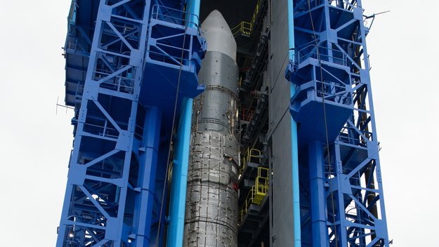
Watch the replay of the Sentinel-3B launch coverage from the Plesetsk Cosmodrome in northern Russia on 25 April
Launch coverage
26.4.2018 16:10 ESA Observing the EarthWatch the replay of the Sentinel-3B launch coverage from the Plesetsk Cosmodrome in northern Russia on 25 April
Rada/odborný rada – správce informačních a komunikačních technologií
26.4.2018 14:20 ČÚZK - volná místa Katastrální úřad pro Plzeňský kraj vypisuje výběrové řízení na místo Rada/odborný rada – správce informačních a komunikačních technologiíRada/odborný rada – správce informačních a komunikačních technologií
26.4.2018 14:20 ČÚZK /Urady/Katastralni-urady/Katastralni-urady/Katastralni-urad-pro-Plzensky-kraj/Uredni-deska/Oznameni-a-jina-uredni-sdeleni/Volna-mista/Rada-odborny-rada-–-spravce-informacnich-a-kom-(1)Rada/odborný rada – správce informačních a komunikačních technologií
26.4.2018 14:20 ČÚZK - předpisy a opatření Katastrální úřad pro Plzeňský krajvypisuje výběrové řízení na místo
Rada/odborný rada – správce informačních a komunikačních technologií
Referent – návrh zápisu v katastru
26.4.2018 14:15 ČÚZK /Urady/Katastralni-urady/Katastralni-urady/Katastralni-urad-pro-Plzensky-kraj/Volna-mista/Referent-–-navrh-zapisu-v-katastruReferent – návrh zápisu v katastru
26.4.2018 14:15 ČÚZK - předpisy a opatření Katastrální úřad pro Plzeňský kraj - Katastrální pracoviště Kralovicevypisuje výběrové řízení na místo
Referent – návrh zápisu v katastru
Referent – návrh zápisu v katastru
26.4.2018 14:15 ČÚZK - volná místa Katastrální úřad pro Plzeňský kraj - Katastrální pracoviště Kralovice vypisuje výběrové řízení na místo Referent – návrh zápisu v katastruVedoucí oddělení právních vztahů k nemovitostem VOPV 15
26.4.2018 14:09 ČÚZK - volná místa Katastrální úřad pro Plzeňský kraj - Katastrální pracoviště Tachov vypisuje výběrové řízení na místo Vedoucí oddělení právních vztahů k nemovitostem VOPV 15Vedoucí oddělení právních vztahů k nemovitostem VOPV 15
26.4.2018 14:09 ČÚZK /Urady/Katastralni-urady/Katastralni-urady/Katastralni-urad-pro-Plzensky-kraj/Uredni-deska/Oznameni-a-jina-uredni-sdeleni/Volna-mista/Vedouci-oddeleni-pravnich-vztahu-k-nemovitostem-VOVedoucí oddělení právních vztahů k nemovitostem VOPV 15
26.4.2018 14:09 ČÚZK - předpisy a opatření Katastrální úřad pro Plzeňský kraj - Katastrální pracoviště Tachovvypisuje výběrové řízení na místo
Vedoucí oddělení právních vztahů k nemovitostem VOPV 15
Vrchní referent/rada – návrh zápisu v katastru NZK 1002
26.4.2018 14:03 ČÚZK /Urady/Katastralni-urady/Katastralni-urady/Katastralni-urad-pro-Plzensky-kraj/Uredni-deska/Oznameni-a-jina-uredni-sdeleni/Volna-mista/Vrchni-referent-rada-–-navrh-zapisu-v-katastru-NZKVrchní referent/rada – návrh zápisu v katastru NZK 1002
26.4.2018 14:03 ČÚZK - předpisy a opatření Katastrální úřad pro Plzeňský kraj - Katastrální pracoviště Plzeň-městovypisuje výběrové řízení na místo
Vrchní referent/rada – návrh zápisu v katastru NZK 1002
Vrchní referent/rada – návrh zápisu v katastru NZK 1002
26.4.2018 14:03 ČÚZK - volná místa Katastrální úřad pro Plzeňský kraj - Katastrální pracoviště Plzeň-město vypisuje výběrové řízení na místo Vrchní referent/rada – návrh zápisu v katastru NZK 1002Vrchní referent v personálním oddělení v Kanceláři ředitele katastrálního úřadu
26.4.2018 13:28 ČÚZK - volná místa Katastrální úřad pro Jihomoravský kraj - kancelář ředitele vypisuje výběrové řízení na místo Vrchní referent v personálním oddělení v Kanceláři ředitele katastrálního úřaduVrchní referent v personálním oddělení v Kanceláři ředitele katastrálního úřadu
26.4.2018 13:28 ČÚZK /Urady/Katastralni-urady/Katastralni-urady/Katastralni-urad-pro-Jihomoravsky-kraj/Volna-mista/Vrchni-referent-v-personalnim-oddeleni-v-KancelariVrchní referent v personálním oddělení v Kanceláři ředitele katastrálního úřadu
26.4.2018 13:28 ČÚZK - předpisy a opatření Katastrální úřad pro Jihomoravský kraj - kancelář ředitelenabízí služební místo
Vrchní referent v personálním oddělení v Kanceláři ředitele katastrálního úřadu
odborný referent – poskytování informací KN a PK, poskytování podkladů, nahlížení do KN
26.4.2018 13:20 ČÚZK - předpisy a opatření Katastrální úřad pro Olomoucký kraj - Katastrální pracoviště Přerovvypisuje výběrové řízení na místo
odborný referent – poskytování informací KN a PK, poskytování podkladů, nahlížení do KN
odborný referent – poskytování informací KN a PK, poskytování podkladů, nahlížení do KN
26.4.2018 13:20 ČÚZK /Urady/Katastralni-urady/Katastralni-urady/Katastralni-urad-pro-Olomoucky-kraj/Uredni-deska/Oznameni-a-jina-uredni-sdeleni/Volna-mista/odborny-referent-–-poskytovani-informaci-KN-a-PK,odborný referent – poskytování informací KN a PK, poskytování podkladů, nahlížení do KN
26.4.2018 13:20 ČÚZK - volná místa Katastrální úřad pro Olomoucký kraj - Katastrální pracoviště Přerov vypisuje výběrové řízení na místo odborný referent – poskytování informací KN a PK, poskytování podkladů, nahlížení do KNUnited for Copernicus
26.4.2018 12:37 ESA Observing the Earth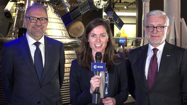
ESA’s Josef Aschbacher and the EC’s Philippe Brunet talk about what the launch of Sentinel-3B means for Copernicus and what’s in store for the future
K-12 Students Introduced to Geospatial Sciences at GEOINT 2018
26.4.2018 12:30 GISCafe.com Webcasts-Webinars USGIF hosts Tampa area students to learn about geospatial intelligence at annual eventTampa, Florida (April 25, 2018) — 121 K-12 students …
ESA and SAP look to World Space Alliance
26.4.2018 12:10 ESA Observing the Earth
With the launch of Sentinel-3B, the first set of Sentinels for Copernicus is now in orbit delivering an almost mind-boggling amount of data. While this wealth of information advances environmental monitoring, it also opens up huge business opportunities. To help bring these data to market, ESA and SAP have joined forces to create the World Space Alliance.
Penn State Research Team Recognized with Lt. Michael P. Murphy Award
26.4.2018 11:26 GISCafe.com Webcasts-Webinars USGIF, the DigitalGlobe Foundation, and Penn State present award at GEOINT 2018 SymposiumTampa, Florida (April 25, 2018) — Tuesday afternoon …
Ursa to Extract Oil Demand Information from ICEYE’s Satellite Data
26.4.2018 11:18 GISCafe.com Webcasts-Webinars Leading New Space companies leverage synthetic-aperture radar capabilities to help decisions makers across the oil industryHelsinki, FINLAND …
Palivové nádrže a křídla pro modul lodi Orion
26.4.2018 10:34 Český Kosmický PortálEvropský servisní modul, který bude poskytovat energii, vodu, vzduch a zajišťovat manévry pro kosmickou loď NASA Orion, udělal další významný krok k dokončení. A to zásluhou instalace palivových nádrží a otestování panelů slunečních baterií.
Ochrana osobních údajů – GDPR
26.4.2018 9:38 GEPROV souvislosti s účinností Nařízení Evropského parlamentu a Rady (EU) 2016/679 (Obecné nařízení o ochraně osobních údajů, tzv.… >>
Pozvánka na konferenci Mapy jsou pro každého – ochutnávka programu
26.4.2018 8:12 GISportal.cz
Konference Mapy jsou pro každého se blíží. Konference letos proběhne v termínu 22 – 23. 5. 2018 na Hotelu Svratka, v lokalitě CHKO Žďárských vrchů na Vysočině. Online registrace za zvýhodněné vložné je k dispozici do 30. 4. 2018. Můžete se těšit například na tyto příspěvky: Senzorová data pro rozhodování ve 3D – Vladimír Plšek, Top […]
The post Pozvánka na konferenci Mapy jsou pro každého – ochutnávka programu appeared first on GISportal.cz.
Konference NEW WAVE - program
26.4.2018 7:00 Česká asociace pro geoinformace Studenti geografické sekce PřF UK a Česká geografická společnost, pořadatelé 10. ročníku mezinárodní geografické konference NEW WAVE, zveřejnili program konference.Konference se bude konat v prostorách PřF UK na Albertově v termínu 31. května - 1. června 2018 a tradičně bude mít na programu příspěvky z oblasti fyzické a sociální geografie, kartografie, demografie,Konference GIVS 2018 se koná již příští týden
26.4.2018 7:00 Česká asociace pro geoinformace Druhou desítku ročníků načne příští týden konference Geoinformace ve veřejné správě 2018. Těšíme se na vás ve čtvrtek 3. května od 9:00 na NovotnéhoBentley Systems Acquires Plaxis, and Complementary SoilVision, to Integrate Geotechnical Engineering within Digital Workflows for Infrastructure Projects
26.4.2018 2:00 Bentley Systems Comprehensive modeling environment now spans geo-structural
and geo-environmental collaboration
Bentley Systems, Incorporated, a leading global provider of comprehensive software solutions for advancing infrastructure, today announced the acquisition of Plaxis, the leading provider of geotechnical software, based in Delft, Netherlands, and the agreement to acquire soil engineering software provider SoilVision, based in Saskatchewan, Canada. The acquisitions, with Bentley’s market-leading borehole reporting and data management software gINT, serve to make Bentley a complete source for geotechnical professionals “going digital.” Finally, BIM advancements can be extended to the essential subsurface engineering of every infrastructure project.
Projects necessarily begin with geotechnical surveys and sampling, captured with gINT for versatile documentation and reporting. Next, professionals perform engineering related to soil properties, soil behavior, and groundwater flow using SoilVision’s SVOFFICE applications, supplemented by Plaxis’ offerings. Then soil-structure interaction is analyzed through Plaxis’ design, simulation, and engineering software (e.g. PLAXIS 2D, PLAXIS 3D).
The new opportunity, by way of digital workflows enabled through Bentley’s comprehensive modeling environment, is for geotechnical applications to be integrated with Bentley’s structural applications (such as STAAD, RAM, and SACS) for unprecedented geo-structural engineering performance. As changes may occur in owner requirements, structural strategies, or site conditions (continuously surveyed through UAVs and Bentley’s ContextCapture for reality modeling), geotechnical analysis could be continuously applied for improved outcomes, as managed through ProjectWise collaboration services.
For today’s infrastructure demands, geotechnical considerations are coming to the fore. Urbanization, for instance, drives growth both vertically and underground, with emphasis on the capacity of foundations and tunnels. And new infrastructure projects of every type depend upon constructed dams, embankments, dikes, levees, and reservoirs to improve their resilience. Moreover, new asset types such as offshore wind turbine structures require new geotechnical analysis capabilities, in this case to be accomplished with Plaxis’ forthcoming MoDeTo software.
Because infrastructure assets are crucially linked to subsurface environs, they are vulnerable to geo-environmental risks including seismic activity, subsidence, and weather impacts. Leveraging new digital workflows which incorporate real-time monitoring and analytics during infrastructure operations, geotechnical professionals can play the increasingly valuable role they deserve in achieving geo-environmental resilience.
Bentley Systems CEO, Greg Bentley said, “My colleagues and I welcome our new teams from Plaxis and SoilVision, which have in common a zeal for applying science for better engineering practice. Dr. Ronald Brinkgreve from Plaxis and Dr. Murray Fredlund, founder of SoilVision, exemplify this. I believe that every geotechnical engineer has benefitted from Plaxis’ continuous advancement, in scope and quality, of tools for their discipline to add value. With a professional and dedicated management team led by Jan-Willem Koutstaal, Plaxis has become one of the most successful software businesses I have ever seen.”
Bentley added, “While most infrastructure engineering disciplines converged around intuitive 3D models, geotechnical applications seem to have followed a less graphically intensive development path, and so have remained isolated from cross-discipline workflows. This ‘disconnected’ mindset prevailed even while Plaxis, SoilVision, and gINT mainstreamed 3D innovations. Our BIM platform’s comprehensive modeling environment will finally embrace the geotechnical profession in digital workflows for every infrastructure project and asset.”
Tony O’Brien, global practice leader for geotechnics for Mott MacDonald, said, “PLAXIS is one of our core analysis tools being used across our global geotechnics practice. When used by experienced specialists, PLAXIS can analyze many of our most complex ground-structure interaction problems. In Bentley’s hands, we have high expectations that we can accomplish more through digital workflows made possible through integration of PLAXIS technology with Bentley’s comprehensive modeling environment—workflows that are compatible with Mott MacDonald’s commitment to connected thinking and solving complex infrastructure challenges.”
About Plaxis
Plaxis is a global market leader in geotechnical engineering software based on the finite element method, offering its applications to users in more than 100 countries worldwide. With a well-established reputation as the industry standard for geotechnical design, Plaxis software serves project owners, contractors, and consultants in civil engineering, oil and gas, offshore industries, and governmental organizations. www.plaxis.com
About SoilVision
Founded in 1997, SoilVision has championed 3D conceptual design and analysis of slope stability, groundwater flow, stress/deformation, contaminant transport, thermal flows in saturated/unsaturated soils, and coupled processes for geotechnical engineers and hydrogeologists. The software solves complex problems by performing numerical modeling and analysis of earth structures in the areas of soil and rock slope stability of earth dams, open pits, levees, embankments, and retaining walls. The software has been utilized for basic designs as well as advanced unsaturated analysis. The software is utilized extensively in the mining industry for the design and evaluation of large engineered earth structures. www.soilvision.com
About Bentley Systems
Bentley Systems is a global leader in providing engineers, architects, geospatial professionals, constructors, and owner-operators with comprehensive software solutions for advancing the design, construction, and operations of infrastructure. Bentley users leverage information mobility across disciplines and throughout the infrastructure lifecycle to deliver better-performing projects and assets. Bentley solutions encompass MicroStation applications for information modeling, ProjectWise collaboration services to deliver integrated projects, and AssetWise operations services to achieve intelligent infrastructure – complemented by comprehensive managed services offered through customized Success Plans.
Founded in 1984, Bentley has more than 3,500 colleagues in over 50 countries, more than $700 million in annual revenues, and since 2012 has invested more than $1 billion in research, development, and acquisitions. www.bentley.com
Related Images:
PLAXIS 3D
Caption: PLAXIS 3D performs three-dimensional analysis of deformation, soil-structure interaction, and stability in geotechnical engineering and rock mechanics.
Attribution: Image courtesy of Plaxis
SoilVision
Caption: SoilVision applications provide capabilities for engineering related to soil properties, soil behavior, and groundwater flow.
Attribution: Image courtesy of SoilVision
Bentley, the “B” Bentley logo, AssetWise, ContextCapture, gINT, MicroStation, ProjectWise, RAM, SACS, and STAAD are either registered or unregistered trademarks or service marks of Bentley Systems, Incorporated or one of its direct or indirect wholly owned subsidiaries. All other brands and product names are trademarks of their respective owners.
Topcon and Bentley training event
26.4.2018 2:00 Bentley SystemsPress Coverage
World Highways, UK
Read the articleApplication of BIM strategy for China’s Dali to Ruili Railway project
26.4.2018 2:00 Bentley SystemsPress Coverage
The BIM Hub, UK
Read the articleBentley Systems Acquires Plaxis, and Complementary SoilVision, to Integrate Geotechnical Engineering within Digital Workflows for Infrastructure Projects
26.4.2018 2:00 Bentley Systems Comprehensive modeling environment now spans geo-structural
and geo-environmental collaboration
Bentley Systems, Incorporated, a leading global provider of comprehensive software solutions for advancing infrastructure, today announced the acquisition of Plaxis, the leading provider of geotechnical software, based in Delft, Netherlands, and the agreement to acquire soil engineering software provider SoilVision, based in Saskatchewan, Canada. The acquisitions, with Bentley’s market-leading borehole reporting and data management software gINT, serve to make Bentley a complete source for geotechnical professionals “going digital.” Finally, BIM advancements can be extended to the essential subsurface engineering of every infrastructure project.
Projects necessarily begin with geotechnical surveys and sampling, captured with gINT for versatile documentation and reporting. Next, professionals perform engineering related to soil properties, soil behavior, and groundwater flow using SoilVision’s SVOFFICE applications, supplemented by Plaxis’ offerings. Then soil-structure interaction is analyzed through Plaxis’ design, simulation, and engineering software (e.g. PLAXIS 2D, PLAXIS 3D).
The new opportunity, by way of digital workflows enabled through Bentley’s comprehensive modeling environment, is for geotechnical applications to be integrated with Bentley’s structural applications (such as STAAD, RAM, and SACS) for unprecedented geo-structural engineering performance. As changes may occur in owner requirements, structural strategies, or site conditions (continuously surveyed through UAVs and Bentley’s ContextCapture for reality modeling), geotechnical analysis could be continuously applied for improved outcomes, as managed through ProjectWise collaboration services.
For today’s infrastructure demands, geotechnical considerations are coming to the fore. Urbanization, for instance, drives growth both vertically and underground, with emphasis on the capacity of foundations and tunnels. And new infrastructure projects of every type depend upon constructed dams, embankments, dikes, levees, and reservoirs to improve their resilience. Moreover, new asset types such as offshore wind turbine structures require new geotechnical analysis capabilities, in this case to be accomplished with Plaxis’ forthcoming MoDeTo software.
Because infrastructure assets are crucially linked to subsurface environs, they are vulnerable to geo-environmental risks including seismic activity, subsidence, and weather impacts. Leveraging new digital workflows which incorporate real-time monitoring and analytics during infrastructure operations, geotechnical professionals can play the increasingly valuable role they deserve in achieving geo-environmental resilience.
Bentley Systems CEO, Greg Bentley said, “My colleagues and I welcome our new teams from Plaxis and SoilVision, which have in common a zeal for applying science for better engineering practice. Dr. Ronald Brinkgreve from Plaxis and Dr. Murray Fredlund, founder of SoilVision, exemplify this. I believe that every geotechnical engineer has benefitted from Plaxis’ continuous advancement, in scope and quality, of tools for their discipline to add value. With a professional and dedicated management team led by Jan-Willem Koutstaal, Plaxis has become one of the most successful software businesses I have ever seen.”
Bentley added, “While most infrastructure engineering disciplines converged around intuitive 3D models, geotechnical applications seem to have followed a less graphically intensive development path, and so have remained isolated from cross-discipline workflows. This ‘disconnected’ mindset prevailed even while Plaxis, SoilVision, and gINT mainstreamed 3D innovations. Our BIM platform’s comprehensive modeling environment will finally embrace the geotechnical profession in digital workflows for every infrastructure project and asset.”
Tony O’Brien, global practice leader for geotechnics for Mott MacDonald, said, “PLAXIS is one of our core analysis tools being used across our global geotechnics practice. When used by experienced specialists, PLAXIS can analyze many of our most complex ground-structure interaction problems. In Bentley’s hands, we have high expectations that we can accomplish more through digital workflows made possible through integration of PLAXIS technology with Bentley’s comprehensive modeling environment—workflows that are compatible with Mott MacDonald’s commitment to connected thinking and solving complex infrastructure challenges.”
About Plaxis
Plaxis is a global market leader in geotechnical engineering software based on the finite element method, offering its applications to users in more than 100 countries worldwide. With a well-established reputation as the industry standard for geotechnical design, Plaxis software serves project owners, contractors, and consultants in civil engineering, oil and gas, offshore industries, and governmental organizations. www.plaxis.com
About SoilVision
Founded in 1997, SoilVision has championed 3D conceptual design and analysis of slope stability, groundwater flow, stress/deformation, contaminant transport, thermal flows in saturated/unsaturated soils, and coupled processes for geotechnical engineers and hydrogeologists. The software solves complex problems by performing numerical modeling and analysis of earth structures in the areas of soil and rock slope stability of earth dams, open pits, levees, embankments, and retaining walls. The software has been utilized for basic designs as well as advanced unsaturated analysis. The software is utilized extensively in the mining industry for the design and evaluation of large engineered earth structures. www.soilvision.com
About Bentley Systems
Bentley Systems is a global leader in providing engineers, architects, geospatial professionals, constructors, and owner-operators with comprehensive software solutions for advancing the design, construction, and operations of infrastructure. Bentley users leverage information mobility across disciplines and throughout the infrastructure lifecycle to deliver better-performing projects and assets. Bentley solutions encompass MicroStation applications for information modeling, ProjectWise collaboration services to deliver integrated projects, and AssetWise operations services to achieve intelligent infrastructure – complemented by comprehensive managed services offered through customized Success Plans.
Founded in 1984, Bentley has more than 3,500 colleagues in over 50 countries, and is on track to surpass an annual revenue run rate of $700 million during 2018. Since 2012, Bentley has invested more than $1 billion in research, development, and acquisitions. www.bentley.com
Related Images:
PLAXIS 3D
Caption: PLAXIS 3D performs three-dimensional analysis of deformation, soil-structure interaction, and stability in geotechnical engineering and rock mechanics.
Attribution: Image courtesy of Plaxis
SoilVision
Caption: SoilVision applications provide capabilities for engineering related to soil properties, soil behavior, and groundwater flow.
Attribution: Image courtesy of SoilVision
Bentley, the “B” Bentley logo, AssetWise, ContextCapture, gINT, MicroStation, ProjectWise, RAM, SACS, and STAAD are either registered or unregistered trademarks or service marks of Bentley Systems, Incorporated or one of its direct or indirect wholly owned subsidiaries. All other brands and product names are trademarks of their respective owners.
3D Design Lowers Costs
26.4.2018 2:00 Bentley SystemsPress Coverage
Industry Today, USA
Read the article